Embed Size (px)
Citation preview

CITY OF NASHVILLE and DAVIDSON COUNTY
TRAFFIC STUDY REQUIREMENTS
FINAL DOCUMENT
Prepared by: Metro Planning Department
in conjunction with Metro Codes Administration Department
and Metro Public Works Department – Transportation Division
(Endorsed 08/12/04)

CITY OF NASHVILLE and DAVIDSON COUNTY TRAFFIC STUDY REQUIREMENTS
FINAL DOCUMENT
Prepared by: Metro Planning Department
in conjunction with Metro Codes Administration Department
and Metro Public Works Department – Transportation Division
(Endorsed 08/12/04)

This Page Reserved for Metro Planning Commission Endorsing Resolution

CITY OF NASHVILLE and DAVIDSON COUNTY TRAFFIC STUDY REQUIREMENTS
Table of Contents
Section 1: Introduction 1 Applicability 1
Section 2: Traffic Study Screening Thresholds 2 Metro Nashville-Davidson County Transportation System Performance Policy 3 Traffic Study Preparer Qualifications 5
Section 3: Types of Traffic Studies 5 Rezoning Analysis 5 Traffic Access Study 6 Traffic Impact Statement 6 Traffic Impact Analysis 6
Section 4: Elements Addressed by a Traffic Study 8 Section 5: Software and Data 10 Section 6: Capacity Analysis 12 Section 7: Mitigation Alternatives 13
Responsibility for Mitigation 15 Transportation Demand Management Plan 15
Section 8: Report Presentation and Contents 16
Tables Table 1: Typical Traffic Impact Study Screening Thresholds 2 Table 2: Traffic Study Thresholds 5 Table 3: Elements of Typical Traffic Studies 9 Table 4: Examples of Mitigation Measures 14
Figures
Figure 1: Traffic Study Review Process 4
Appendices Appendix A - Recommended Report Outline 20 Appendix B - Forms 25
Pre-Study Scope Determination Conference Check-List 26 Form A – Initial Traffic Study Screening Evaluation 27 Form B – Request for Review/Comments of Traffic Study 28 Form C – Finding of No Significant Impact 29
Appendix C – Sample TDM Plan 30
Acknowledgements
The Metro Planning Department would like to acknowledge the contributions made to the development of this document by the following organizations and companies: Nashville-Davidson County Metro Public Works Department, Traffic and Parking Division
Nashville-Davidson County Metro Codes Administration Department
Institute of Transportation Engineers – District 5 Tennessee Department of Transportation University of Tennessee Transportation Engineering Assistance Office Nashville Area Metropolitan Planning Organization The Transportation Planning and Engineering Consultants of Middle Tennessee
• Barge, Waggoner, Sumner, Cannon • Fischbach Transportation Group, Inc. • Gresham Smith and Partners • Ragan Smith Associates • RPM Transportation Consulting, LLC
Middle Tennessee Homebuilders Association Tri-Counties Metropolitan Planning Commission, Lansing Michigan Florida Department of Transportation Georgia Regional Transportation Authority Maryland-National Capital Parks and Planning Department – Montgomery County The City of Franklin, Tennessee The City of Clarksville, Tennessee The City of Cookeville, Tennessee The City of Athens, Georgia - Public Works Department The City of Austin Texas - Public Works Department The City of Minneapolis Planning and Public Works Department
Traffic Study Guidelines Nashville and Davidson County Draft Document 1
Section 1: Introduction The Metropolitan Government of Nashville-Davidson County is responsible for providing a safe and efficient transportation system. Article III of Chapter 17.20.140 of the Zoning Regulations for the Metropolitan Government of Nashville and Davidson County states that a Traffic Impact Study be completed for the purpose of identifying the improvements, if any, that are needed to offset the additional traffic generated by a proposed level of development. These improvements may include, but are not limited to:
The provision of traffic signals
The addition of turning lanes
Widening roads
New roads
Safety improvements
Provision of facilities to support transit operations
Provision of facilities to support pedestrian and bicycle movement i.e. sidewalks, bike lanes, and greenways
The purpose of a Traffic Study is to provide Metro review staff with sufficient information concerning the transportation impacts of a project and to determine appropriate mitigation measures so as to inform decision-makers so that they make educated decisions within the development review and approval process. The Traffic Study also assures that the applicant is aware of traffic and access conditions that may affect the use of, or benefit derived from the property, enabling them to make decisions about transportation system investments that will favorably impact their project. Impacts to the transportation system may include increased congestion, diminished safety, and conflicts with site access. During the development review and rezoning processes the Metro Department of Public Works’ Chief Traffic Engineer, hereafter referred to as the Transportation Manager, or a designee of the Transportation Manager will utilize the traffic study to assess the impacts of proposed developments on the transportation system. The Transportation Manager and the designee Transportation Manager are hereafter referred to as the Metro Reviewer.
The purpose of this document is to provide guidance to developers and rezoning petitioners regarding acceptable methodologies for producing traffic studies as well as the required contents of the traffic study. This document will also serve as guidance for the Metro Reviewer, assisting the Reviewer to provide instruction to developers and consultants so that consistency in the review process can be achieved.
Applicability This document specifically applies to:
All applications for zoning district changes All applications for preliminary planned unit developments that meet minimum
trip generation thresholds All applications for final planned unit developments that differ in land use and
size from approved preliminary plans All applications for preliminary subdivision plats that meet minimum trip
generation thresholds All applications for final subdivision plats that increase the number of proposed
units or change the proposed mix of land uses from the approved preliminary subdivision plats
Requests for building permits of land uses that meet the minimum trip generation thresholds and do not have an approved TIS on file

Traffic Study Guidelines Nashville and Davidson County Draft Document 2
Exceptions to the applicability of this document include: Any property located within the downtown loop (inner loop) formed by
Interstates 65, 40, and 24 Once approved by the Metro Transportation Manager, a traffic study shall be effective for a period of five years. Projects that have a multiyear build out and have demonstrated due diligence towards completing the proposed development shall be exempt from the study sunset requirement. Due diligence is defined as a project that has achieved at least 50% of the total project’s build out (in units or size) by the end of the five year period. Developments seeking permits who have not demonstrated due diligence towards the completion of the project and whose impact study is in excess of five years old shall be evaluated by the Metro Reviewer. This evaluation is necessary to determine the degree to which background conditions have changed since the original traffic study was approved. If needed, a new traffic study will be required in order to provide information to help determine and decide if any additional mitigation measures are necessary.
A new traffic study shall be required if significant changes are made to a development. Significant changes include, but are not limited to:
Change from a single land use to multiple land uses provided the new land uses generate an additional 250 new peak hour trips or increase peak hour trips by 35%, where the greater of the two applies.
Changes to from one land use to another that either generates an additional 250 peak hour trips or increase peak hour trips by 35%, where the greater of the two applies. Examples of this might include a change from specialty retail to fast food, multi-family residential to fuel station with convenience store, single-family residential to shopping center, etc.
Projects will be screened using the criteria identified above in order to determine the need to complete a new study.
Section 2: Traffic Study Screening Thresholds Chapter 17.20.140 of the Zoning Regulations establishes minimum screening thresholds that may be used to determine if a Traffic Impact Study is needed. Table 1 illustrates these thresholds.
Table 1: Typical Traffic Impact Study Screening Thresholds
Development Type Size Threshold Trip Generation Threshold
Residential 100/du N/A
Non-residential 50,000 sq ft N/A
Residential Mixed Use (without reductions) N/A
100/pkhr vehicle trips
1,000 daily vehicle trips

Traffic Study Guidelines Nashville and Davidson County Draft Document 3
Other reasons that a Traffic Impact Study may be required include, but are not limited to:
An application is submitted to rezone a parcel(s) or change the use of a parcel(s) to allow a more intensive trip generating use.
The project is located at or near a signalized intersection operating below Level of Service D.
The project will provide a through connection that links collector roadways and/or roadways of higher classification.
The street segment serving the project does not meet current Metro Public Works minimum street standards and/or does not conform to acceptable geometric configurations as defined by Metro Public Works and/or the Tennessee Department of Transportation.
The project is located near a location identified by the Transportation Manager as a high crash/accident location.
The Metro Reviewer has specific concerns about site access and/or safety issues.
Chapter 17.20.140 of the Metro Zoning Regulations explicitly gives the Metro Department of Public Works’ Transportation Manager the discretion to require that a traffic impact study be submitted.
An applicant shall not avoid the intent of this requirement by submitting piecemeal applications or approval requests for subdivision plats, preliminary or site development plans, or building permits. Figure 1 illustrates the traffic study process.
Metro Nashville-Davidson County Transportation System Performance Policy The Transportation Facility Policy contained in the Mobility 2010 Transportation Plan for Nashville-Davidson County establishes a minimum policy goal for acceptable roadway function at level of service (LOS) “D.” This applies to both roadway segments and signalized intersections. On major streets, left-turns at unsignalized intersections, the policy goal is LOS “E”. The policy goal for side street approaches with major streets is LOS “E”. Major Streets are defined and identified in the adopted Major Street Plan, and the currently adopted Major and Collector Streets Plan map.
The level of service goals for signalized and unsignalized intersections identified above are not regulatory requirements. Instead, these LOS goals are utilized as screening tools to assist in the determination of whether or not the impact of individual projects might be mitigated. Projects whose study intersections include signalized intersections that operate at LOS “D” or better under background conditions may not be required to provide mitigation beyond that needed to facilitate access into and out of the project site and/or improve traveler safety adjacent to the project site. However, projects whose study intersections include signalized intersections that operate below LOS “D” under background conditions will require that the project provide mitigation in order to return vehicle delay to background conditions. This screening methodology also applies to unsignalized intersections where the LOS policy goal for left turns and minor street approaches is LOS “E”.
Desired changes to the LOS policy goals should be addressed with updates of the Mobility 2010 Transportation Plan for Nashville-Davidson County.

4
Figure 1: Traffic Study Review Process
Review Agencies
Metro Codes Admin. Department Metro Planning Department Metro Public Works Department
If Disagreement with
Recommendations
Developer/Applicant Completes and Submits Form A: Initial Traffic Study Screening Evaluation
If All in Agreement with Study
Study Required
Form A is reviewed by Transportation
Manager
Pre-Study Scope Determination Meeting
Study Prepared by Consultant
(Submits for Review with Form B)
Study Distributed to Review Agencies
Transportation Demand Management (TDM) Plan Prepared by Consultant
Post Study Meeting between Metro Review Agencies,
Consultant, and Developer
Revision of Study based on Outcome of Post Study
Meeting
Metro Staff Evaluation Issued and Mitigation Measures Recommended (if any)
Planning Commission Action on Proposed Development
Permit Process if Development Approved
Metro Council Action (if required)
Distribution of Form C, Finding of No Significant
Impact (FONSI) to Review Agencies
Study Not Required
Comments will be provided not later than 15 business days after receipt of a request to review a submitted study. (See Form B)
Resolution to Disagreement
If Necessary

5
Traffic Study Preparer Qualifications The individual completing and/or supervising the preparation of traffic studies shall be a registered Professional Engineer (P.E.) in good standing with the State of Tennessee. Any elements of the study that involve roadway or traffic signal design work shall be prepared or supervised by a registered P.E. with specific training in transportation engineering. All traffic studies and/or reports submitted to Metro for final review will be sealed by the engineer overseeing the completion of the study(s) and/or document(s).
Section 3: Types of Traffic Studies There are four types of traffic studies:
Rezoning Analysis Traffic Access Study Traffic Impact Statement Traffic Impact Analysis
Table 2 illustrates the recommended thresholds that the Transportation Manager will use as a guide for determining the level/type of study. These recommended thresholds provide for a more complete evaluation tool to assess the impact of development during the peak travel periods, the time of day when congestion is at its worst. These recommendations are based on information gathered from the Institute of Transportation Engineers, the Michigan Tri-County Regional Planning Commission’s Evaluating Traffic Impact Studies guidebook, and the Florida Department of Transportation’s Site Impact Handbook.
Table 2: Traffic Study Thresholds
Traffic Study Type Threshold*
Rezoning Analysis (RA)
250 pkhr trips or at the Discretion of
Transportation Manager
Traffic Access Study (TAS)
50 – 99 new peak hour trips
Traffic Impact Statement (TIS)
100 – 249 new peak hour trips
Traffic Impacts Analysis (TIA)
250+ new peak hour trips
* Revised thresholds based on ITE recommended trip thresholds.
Rezoning Analysis The Rezoning Analysis (RA) is different from those for specific uses in that its purpose is to analyze the capacity of the existing transportation system to accommodate potential new development in the absence of mitigation measures. As such, the Metro Reviewer shall conduct a detailed screening to determine if an RA is warranted. This will be done by comparing the typical and maximum potential trip generation of representative uses permitted in the existing zoning with the typical and maximum representative uses permitted under the requested zoning. The Metro Planning Department will identify both typical and maximum land uses in the current and requested zoning districts for use in the analysis. The results of the analysis comparing the potential existing and

6
potential future land uses, along with the additional data provided by the applicant will be utilized to inform the decision making process.
It is important that the applicant understand the Metro Reviewer’s obligation to consider all of the potential uses that could be developed under the requested zoning, regardless of any specific use being proposed. Upon determination of the need for an RA, the applicant shall provide additional information, as identified in Table 3, to the Metro Reviewer. Completing a Rezoning Analysis does not negate the need to complete a more thorough traffic study upon submission of development plans for the subject property(s) and/or requests for the issuance of permits for construction. Specific mitigation measures will be identified through the detailed traffic study process.
Traffic Access Study Traffic Access Study (TAS) are required for smaller scale projects that are not anticipated to have a significant impact on the overall transportation system, but will have impacts at the site access. It is the first of the traffic studies’ mandated by Chapter 17.20.140 of the Zoning Regulations. Recommended peak hour trip thresholds for the conduct of a TAS is between 50 and 99 new vehicle trips. In addition, Traffic Access Study shall be required in cases where the proposed development will create a through connection between Collector roadways and/or roadways of greater functional classification. The Zoning Regulations require that the project access points to public roadways, private driveways, and joint access easement be evaluated. This includes those locations that the Metro Transportation Manager feels are necessary to provide for an adequate review of the proposed project’s impact. The Metro Reviewer, in consultation with the applicant/developer will determine the TAS study boundaries and the scope of work for the study during the Pre-Study Scope Determination Meeting. Table 3 illustrates the recommended elements to be included in a Traffic Access Study.
Traffic Impact Statement Traffic Impact Statements (TIS) evaluate impacts at the site access points and appropriate nearby intersections. The thresholds for conducting a TIS are between 100 and 249 new peak hour trips.
The study boundaries shall include all roadways serving the project, and all intersections up to the first collector roadway or roadway of higher functional classification. This includes those intersections that the Metro Transportation Manager feels are necessary to provide for an adequate review of the proposed project’s impact. The Metro Reviewer, in consultation with the applicant/developer will determine the TIS study boundaries and the scope of work for the study during the Pre-Study Scope Determination Meeting. Typical elements to be included in the TIS are identified in Table 3.
Traffic Impact Analysis Traditional Traffic Impact Analysis (TIA) evaluates impacts at site access points and appropriate nearby intersections. Table 3 illustrates that the TIA will provide a more robust analysis of the impacts of site-generated traffic on the transportation network than the analysis provided in a TIS.
The study parameters will include an analysis of the project’s access points, an analysis of all roadways serving the project, an analysis of all intersections up to the first collector roadway or the first roadway of higher functional classification, and the intersections of these roadways with arterial roadways. This includes those intersections that the Metro Transportation Manager feels are necessary to provide for an adequate review of the

7
proposed project’s impact. The Metro Reviewer, in consultation with the applicant/developer will determine the TIS study boundaries and the scope of work for the study during the Pre-Study Scope Determination Meeting. The threshold for a TIS is 250 new peak hour trips.
Authority for Requiring Studies
Chapter 17.20.140 of the Metro Zoning Code specifically empowers the Metro Transportation Manager with the discretion to require that a traffic study be completed. In short, a traffic study may be requested whether or not the trip thresholds are met. The LOS screening criteria included in Mobility 2010, as well as evaluation of existing and background conditions may be utilized to determine the necessity for a traffic study. Crash rates may also be used as a screening to tool to help determine the necessity for a traffic study. Finally, the applicant may request a pre-study scoping meeting if they feel that a traffic study is needed.
Comments will be provided not later than 15 business days after receipt of a request to review a submitted study. (See Form C)
8
Section 4: Elements Addressed by a Traffic Study Prior to starting work on a Traffic Study, a Pre-Study Scope Determination Conference will be held. At this meeting the Metro Reviewer will determine the type of study to be performed. The Metro Reviewer will also consult with the developer and the consultant preparing the Traffic Impact Study in order to discuss any potential issues and concerns with the project and develop an agreement about the study’s scope of work.
The applicant shall bring to the Pre-Study Scope Determination Meeting:
Form A – Initial Traffic Study Evaluation.
A complete description of the development. This shall include a site map that details building footprints, the number of units/unit size, access points, internal roadways (if any), street, proposed sidewalks and bicycle facilities, and the location and number of proposed parking spaces (if applicable). The best available documentation will be sufficient to use during the pre-study scoping meeting. Finalized documents should be submitted, when available, for inclusion in the project file.
If the development is to be phased, the size, location, and timing of each phase.
Identification of any unique or unusual features such as floodplain, floodway, steep slopes, etc.
The applicant shall also be prepared to respond to the following questions:
What is the relationship of the development to surrounding land uses i.e. interconnectivity with surrounding neighborhoods, pedestrian and bicycle facilities, accessibility to schools and public facilities, etc?
Can the proposed development be served by public transportation?
Does the design provide facilities for bicycles and pedestrians who need to gain access to, pass by, or pass through the development?
Any other items/materials that will facilitate the preparation and accuracy of the traffic study.
The applicant’s traffic study preparer will include a complete and accurate analysis of the issues identified during this meeting in the traffic study.
Table 3 illustrates the typical elements that are usually included in each of the different levels/types of traffic studies.

9
Table 3: Elements of Typical Traffic Studies
Task
Rezoning Analysis
Traffic Access Study
Traffic Impact Statement
Traffic Impact Analysis
Pre-Study Meeting √ √ √ √
Impact Analysis:
Study area and road summary √ √ √ √
Site Plan that includes: adjacent land uses, driveways, and roadways (existing and dedicated) √ √ √
Project description to include planned land uses, internal circulation for all modes, site access, etc. √ √ √
Details of other projects (both approved and permitted) in the study area √ √ √
Existing conditions analysis (LoS)(1) at site √ √ √
Existing conditions at nearby intersections √ √ √
Background traffic growth √ √ √
Existing conditions + Background traffic (future w/o project) √ √ √
Trip generation for specific uses √ √ √ √
Trip distribution analysis √ √ √ √
Future + project conditions analysis at site √ √ √
Future + project conditions analysis for nearby intersections √ √ √
Mitigation identification and evaluation
Comparison of trip generation assoc. with uses allowed, requested v. current permitted uses √
Sight distance evaluation √ √ √
Opposing driveway locations √ √ √
Site Issues:
Evaluate number, location and spacing of access points √ √ √
Access design, queue lengths, etc. √ √ √
Site circulation √ √ √
Other Analyses:
Accident/Crash History √
Signal coordination analysis √
Signal warrant analysis √
Turn lane warrant analysis √ √ √
Consistency with Metro roadway standards √ √ √
TDM mitigation measures
Segment/Link Analysis
Key: √ = required = may be appropriate on a case-by-case basis
Notes: 1. LoS = Level of Service as determined by techniques outlined in the Highway Capacity Manual. Adapted from Evaluating Traffic Impact Studies: A Recommended Practice for Michigan Communities. Tri-
County Regional Planning Commission, 1994.

Traffic Study Guidelines Nashville and Davidson County Draft Document 10
Section 5: Software and Data Traffic Analysis Software
The software used will be based on the Transportation Research Board’s Highway Capacity Manual (HCM) and utilize the HCM’s formulas in order to conduct capacity analysis for all transportation system scenarios. The data from the software package will be exportable to the McTrans’ Highway Capacity Software 2000 package. The software used will be able to analyze intersection operations including signal timing and phasing analysis, pedestrian calls, queue lengths, and analysis of street segments.
Software packages such as CorSim, Sim Traffic, Traffix, and Synchro that perform micro-simulation of traffic dynamics including simulations of transit and heavy vehicle operations, as well as provide graphic descriptions of intersection and link operations are not required, but may be utilized. However, data from these software must be reported in HCM format, and meet the basic criteria for exporting data as specified by this document.
Specialized software for transit operations analysis, turning templates, geometric analysis, and noise mitigation analysis may be used separately from the traffic operations analysis software. The use of these types of software packages for analysis of elements included within traffic studies submitted to Metro must receive prior approval of the Metro Reviewer.
A Sim Traffic model for the City of Nashville’s Central Business District is available for use by the applicant in the preparation of traffic studies. In the event that a traffic study should be required within the Central Business District, this model shall be utilized.
Accident, Collision, and Crash Records If needed, accident records can be obtained from the Metro Public Works
Department, the Metro Police Department, the Tennessee Department of Public Safety, or the Tennessee Department of Transportation. Accident data for individual roadway segments and locations not provided by one of the agencies listed above will not be accepted. Data shall cover a two-year period.
Approved Developments Data about properties located within the study area boundaries are available
on the websites of the Metro Council, the Metro Clerks Office, the Metro Planning Commission, and the Metro Codes Administration Department. Applicants are to identify any approved development and use this information in the completion of their traffic study. Data available on these websites includes: planned unit developments, approved rezoning, approved change of use requests, construction permits, and any conditions of approval that is associated with them. Information on approved subdivisions is available upon request from the Metro Planning Department. If available, the conditions of approval shall be included in the study analysis.
Approved Traffic Studies The Metro Planning Commission and/or the Metro Department of Public Works
will make traffic studies for approved developments within the study area boundaries available to the consultant.
Traffic Study Guidelines Nashville and Davidson County Draft Document 11
Average Daily Traffic (ADT) Counts The Tennessee Department of Transportation or the Metro Public Works Average
Daily Traffic (ADT) counts may be utilized, if available, to assist in the determination of a roadway’s historic growth rate. The consultant shall provide documentation of the methodology used to determine the growth rates within the traffic study document.
ADT counts may also be utilized to determine the amount of traffic entering and exiting the study area, and may also be used to verify counts collected by the consultant. The most recent ADT should be used. However, traffic counts that are more than - two years old may not be used except to determine historical trends.
Intersection Traffic Volumes Turning movement counts must have been collected within two-years prior to
the time the traffic study scope was approved. Counts shall be collected on school days, and when necessary because of the land use being requested, on weekends and off-peak hours to include midday and evenings. Seasonal adjustment factors are available for use. The consultant shall confer with Metro Public Works for the availability of this data. If turning movement counts for the study intersections are not available through the Metro Public Works Department, the consultant will be required to collect this data for both the A.M. and P.M. peak travel periods. A printed summary of the data should be included as part of the report. The summary will include intersection drawings with lane configurations, intersection composite and individual turning movement peak hour factors, heavy vehicle percentages (if required), and traffic signal phasing. In addition, either a Jamar file or a text file of the data shall be submitted with the study.
Manuals and Guidance Documents The most recent versions of the Institute of Transportation Engineers’ Trip
Generation, and the Transportation Research Board’s Highway Capacity Manual shall be used. In some cases, trip generation characteristics based on local data specific to a particular location or land use may be used. If the applicant’s traffic study preparer believes that the proposed project fits the criteria for this special exception to using the ITE Trip Generation manual, they may request that the Metro Transportation Manager allow the revised rates and/or formulas to be used. The rates and formulas must have been derived using the ITE trip generation study methodology.
Other documents to be used are the Metro Zoning Regulation, the Subarea (Community) Plans for the area where the project is located, the current Major Street and Collector Plans, the Strategic Plan for Sidewalks and Bikeways, the Metro Capital Improvements Budget, the Metro Department of Public Works project schedules, Tennessee Department of Transportation project schedules, and any documents identified by the Metro Reviewer as being necessary.

Traffic Study Guidelines Nashville and Davidson County Draft Document 12
Signal Timing Plans The Metro Department of Public Works, upon request, will provide the consultant
with signal timing plans for signalized intersections within the study area.
Transportation Improvement Program and Long-Range Transportation Plan The transportation Improvement Program (TIP) and the Long-Range
Transportation Plan (LRTP) may be obtained from the Nashville Area MPO. These documents shall be consulted in order to determine what projects and/or transportation improvements are planned for an area or specific location, and also to determine when the project might be completed.
Congestion Management System The Congestion Management System (CMS) may be obtained from the Nashville
Area MPO. This document provides limited background information about the operating characteristics of major transportation corridors. Its purpose is to continually locate congestion, determine its causes, identify and evaluate strategies to reduce congestion and monitors the effectiveness of implemented congestion strategies. Federal CMS regulations require that appropriate consideration be given to all reasonable alternatives and strategies to reduce single occupant vehicle travel.
Section 6: Capacity Analysis Until such time as background traffic volumes become available from the Nashville-Davidson County travel demand model, the applicant’s study preparer either shall use a generalized growth rate or a facility specific growth rate in order to derive background traffic volumes to be used in the capacity analysis. The transportation consultant may be instructed at the Pre-Study Scope Determination Meeting to obtain growth rates either from the Metro Public Works Department, or to derive growth rates using historic traffic volume data and linear regression techniques. If the growth rate is derived independent of the Public Works Department the consultant must document all data and calculations within the study.
A traffic study is basically a before and after analysis. Following are the basic scenarios of capacity analysis for study intersections and affected roadways.
1. Existing Traffic - It is important to identify the existing operating conditions of the study area intersections and roadway segments in order to determine existing deficiencies in the transportation system, and to allow a comparison of future conditions.
2. Background Traffic - A traffic study is not prepared in a void. Projects that have an opening date at least one year away will be impacted by background traffic. That is, background traffic consists of the natural traffic growth (traffic from approved projects and population growth), absent the proposed project. An analysis of this increased traffic shall be conducted in order to determine the future operating conditions of the roadway at the planning horizon without the project.

Traffic Study Guidelines Nashville and Davidson County Draft Document 13
3. Project Traffic - An analysis of the traffic associated with the proposed development is a requirement of each of the different types of traffic studies described in this document. A “trip generation” for the project is conducted in order to complete this analysis. A trip is defined as a single, one-way movement. Sources for trip generation are listed in the Section 5 of this document. During the analysis of project traffic, access and internal circulation shall be evaluated as well. Reductions in generated trips shall be conducted in good faith and shall utilize ITE approved data and methodologies for pass-by trips and internal capture.
Trip distribution and assignment methods shall be approved by the Metro Reviewer prior to distributing traffic to the roadway network and reducing the number of trips for a proposed project in a traffic study.
4. Future Traffic This is the “after” portion of the traffic study process that was described previously. Analysis of the future traffic conditions includes examination of background traffic for the study area increased by the project traffic volumes.
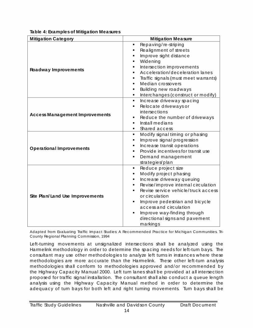
Section 7: Mitigation Alternatives The major benefit of a traffic study is to determine what, if any, mitigation measures are needed. Mitigation measures are not limited to roadway construction or other physical improvements. Mitigation can involve anything from physical or operational improvements along the roadway and site access points, to programs and incentives designed to specifically alter travel behavior, or any combination of these. Mitigation measures may also include alteration of the proposed development to reduce the number of peak hour trips generated or even denial of the project altogether. Table 4 presents some examples of mitigation measures. The Congestion Management System document developed by the Nashville Area MPO also contains a list of tools and strategies that can be applied to address congestion caused by specific situations.
Traffic Study Guidelines Nashville and Davidson County Draft Document 14
Table 4: Examples of Mitigation Measures Mitigation Category Mitigation Measure
Roadway Improvements
Repaving/re-striping Realignment of streets Improve sight distance Widening Intersection improvements Acceleration/deceleration lanes Traffic signals (must meet warrants) Median crossovers Building new roadways Interchanges (construct or modify)
Access Management Improvements
Increase driveway spacing Relocate driveways or
intersections Reduce the number of driveways Install medians Shared access
Operational Improvements
Modify signal timing or phasing Improve signal progression Increase transit operations Provide incentives for transit use Demand management
strategies/plan
Site Plan/Land Use Improvements
Reduce project size Modify project phasing Increase driveway queuing Revise/improve internal circulation Revise service vehicle/truck access
or circulation Improve pedestrian and bicycle
access and circulation Improve way-finding through
directional signs and pavement markings
Adapted from Evaluating Traffic Impact Studies: A Recommended Practice for Michigan Communities. Tri-County Regional Planning Commission, 1994
Left-turning movements at unsignalized intersections shall be analyzed using the Harmelink methodology in order to determine the spacing needs for left-turn bays. The consultant may use other methodologies to analyze left turns in instances where these methodologies are more accurate than the Harmelink. These other left-turn analysis methodologies shall conform to methodologies approved and/or recommended by the Highway Capacity Manual 2000. Left turn lanes shall be provided at all intersection proposed for traffic signal installation. The consultant shall also conduct a queue length analysis using the Highway Capacity Manual method in order to determine the adequacy of turn bays for both left and right turning movements. Turn bays shall be

Traffic Study Guidelines Nashville and Davidson County Draft Document 15
sized to accommodate the 95th percentile confidence level and shall be designed per the AASHTO Policy on Geometric Design of Highways and Streets (Green Book).
The consultant shall identify, analyze, and discuss mitigation measures in the traffic study. These mitigation measures shall be specific and feasible actions whose implementation will improve adverse transportation conditions. A mitigation measure shall adequately avoid, minimize, rectify, reduce over time, or compensate an impact. All mitigation measures that require roadway widening shall be submitted on an aerial photograph or surveyed plan. The exhibit may include a generalized drawing of the proposed mitigation, and shall show existing conditions, property lines, and geographical conditions. This exhibit shall be drawn to a scale that allows the Metro Reviewer to determine the feasibility of the proposed mitigation.
The mitigation measures shall consider the following:
Scheduled improvements
The phasing of the project’s development
A logical phasing of improvements
Responsibility for implementation and
Generalized cost estimates
Responsibility for Mitigation Chapter 17.20.140.E of the Zoning Regulations provides the foundation for requiring the applicant’s participation and support of the implementation of off-site mitigation efforts. It states, “Mitigation efforts may rely on improvements for which council has adopted a resolution appropriating funds.” Any required traffic improvements that have not been funded or otherwise completed by the Metropolitan Government shall be completed by the developer prior to the issuance of a use and occupancy permit by the zoning administrator provided that the improvement has been identified in either the traffic study or through subsequent analysis of the traffic study by Metro review staff as being necessary to mitigate the impacts of the development. When it is demonstrated that a development will only partially contribute to the need for additional off-site improvements, the zoning administrator or the planning commission (as applicable) may require a “pro-rata contribution” be applied to the total cost of providing the improvement. Through the traffic study process, it is possible to identify the proportional impacts of the proposed development on intersections and roadway segments near the development site. In doing so (identifying the impacts of the development), a percentage of the financial responsibility that the developer will bear for the implementation of the mitigation measures can also be easily identified. As stated previously, mitigation costs and/or efforts must be discussed within the traffic study. The Metro Reviewer, in consultation with the consultant and developer, will make the final recommendation of the appropriate mitigation measures, if needed.
Transportation Demand Management Plan One of the transportation policies articulated in Mobility 2010 is that Metropolitan Nashville-Davidson County’s transportation efforts shall focus on feasible alternatives to the continued expansion of highways and the prevalent use of single occupancy vehicle. This policy is in keeping with the policy articulated in the Congestion Management System Plan developed by the Nashville Area MPO.

Traffic Study Guidelines Nashville and Davidson County Draft Document 16
In order to maximize the capacity of the roadway system, a Transportation Demand Management (TDM) plan shall be completed as part of the traffic study for developments that generate 1,000 or more peak hour trips, or is located in areas where physical mitigation is infeasible because of environmental constraints and/or disproportionate costs and benefits. The TDM plan shall identify and document elements of support (financial, political, community, etc.) for TDM strategies, as well as establish an implementation schedule and strategies for monitoring the effectiveness of TDM measures. The applicant may include as evidence of compliance, tenant lease agreements, deed restrictions, and/or covenants. Possible TDM measures include, but are not limited to:
Limitation to free parking and parking subsidies Provision of priority parking spaces for carpool and vanpools Establishment of mode split goals Arrangements with transit provider to extend services to include property Transit shelters* Transit shuttle services* Transit incentives and subsidies for employees* Transit kiosks and information stations* On-site sale of transit passes* Commitment to participate in an existing or future Transportation Management
Association Establishment of a residential Transportation Management Association Flexible and non-traditional/non-peak work schedules Telecommuting options Funding and/or staffing of Transportation Coordinator positions for employers Communication, education, and outreach programs Carpool incentives and parking spaces Bicycle facilities such as showers, changing rooms, bike lockers, maps, etc. Survey development/implementation to check for compliance Vehicular access restrictions
* Only if transit service is available
Section 8: Report Presentation and Contents Traffic studies submitted for review shall follow a predetermined format as shown in Appendix A: Recommended Report Outline. This format is intended to provide consistency in the preparation and review of traffic studies. The Metro Reviewer, along with any other reviewing agencies, will evaluate and comment on the draft traffic study over a period not to exceed fifteen (15) business days. The consultant will make the necessary revisions and submit the final traffic study to the Metro Department of Public Works for acceptance. It is the intent of this document to provide sufficient guidance as to minimize the number of multiple draft versions of the traffic study so that comments can be provided in a timely manner, allowing projects to proceed efficiently through the development review cycle.
The consultant shall provide to Metro, both a physical and electronic copy of the traffic study’s draft and final documents. Electronic copies of the draft and final document shall be provided to Metro in Adobe portable document format (PDF). All graphics used in the report shall be in JPEG format.

Traffic Study Guidelines Nashville and Davidson County Draft Document 17
A Civil or Traffic Engineer who is currently in good standing with the State of Tennessee shall seal the final report.
The final report will meet the following requirements:
1. The report shall clearly identify the name of the development (all past names as well), the applicant(s), and the case number (Metro Planning Dept. and/or Metro Codes Dept.) if applicable.
2. The report shall clearly state the purpose and objective of the study.
3. The report shall be presented in a clear and logical sequence. It shall lead the reader step-by-step through the various states of the process. It will clearly state the conclusions of the study and the resulting recommendations. It shall include graphics, tables and charts to clearly identify the project the project location, proposed project phasing, impacts, issues, and solutions.
4. All computerized analysis output sheets and supporting raw-count data, average daily traffic (ADT), turning movement, queue length analysis, level of service calculations, intersection delay data, etc shall be included in a technical appendix to the report. All assumptions used in the calculations must be referred to the appropriate tables, chart, or page in approved publications (e.g. volume/capacity ratios, vehicle operating speeds, trip generation rates, etc.). Calculations must be comprehensive and clear.
5. All maps and graphics involving improvements must be drawn to a scale that allows roadway geometrics to be approximately dimensioned (e.g. road width, lane width, 95th percentile confidence level queue length, etc.) and allows the Metro Reviewer to accurately evaluate them. Intersection geometrics must include bus stops, parking areas, pedestrian crossings, driveways, turn restrictions, etc.
6. The traffic study shall identify traffic congestion, safety problems and/or other deficiencies of the future transportation system across all modes, with and without the proposed development i.e. lack of pedestrian facilities, insufficient transit service, etc. The study shall incorporate identified and/or planned transportation improvements being made by other public agencies (e.g. Tennessee Department of Transportation, Regional Transit Authority, Metro Transit Authority, etc.) or private organizations that are funded and expected to be functional by planning horizon of the study.
7. Descriptions of on-site issues including number and location of driveways, circulation, bicycle, and pedestrian facilities, truck access and operations, transit and safety shall be presented. The Transportation Manager may request that a discussion of parking needs and presentation of parking layout/issues be presented in the report.
8. The report will address left-turns and utilize the Harmelink or other appropriate HCM methodology for analyzing left-turning movements. Turn bays shall be sized to accommodate the 95th percentile confidence level as determined by the Highway Capacity Manual method and shall be designed per the AASHTO Policy on Geometric Design of Highways and Streets (Green Book).

Traffic Study Guidelines Nashville and Davidson County Draft Document 18
9. The report shall evaluate potential improvement measures needed in order to mitigate the impact of the development to the background delay levels or to the level of service standards defined by Nashville-Davidson County transportation policies.
10. The traffic study shall contain recommendations for site access and transportation improvements needed to maintain traffic flow to, from, within, and past the site at an acceptable and safe level of service.
11. Description of coordination efforts with affected jurisdictions outside of Metro Nashville-Davidson County’s purview shall be included, if necessary. Coordination efforts should minimally include correspondence with the affected jurisdiction to inform them about the traffic study. Other coordination efforts might include:
Providing the affected jurisdiction with a copy of the traffic study
Providing a written invitation to the affected jurisdiction to participate in the traffic study review process, or
Providing Metro review staff with the contact information for their counterparts in the other jurisdiction
Coordination efforts should be pursued when a development crosses jurisdictional boundaries, or is directly adjacent to another jurisdiction and the majority of the distributed traffic from the development will impact the roadways of an adjacent jurisdiction.
11a. If required, Transportation Demand Management (TDM) concepts must be fully explored and discussed to the satisfaction of the Metro Reviewer. A generalized statement offered as a solution to a specific problem is not acceptable. The solutions offered must be backed by data to confirm practicality, the probability for successful implementation, and the conditions under which these measures might be implemented. Surrogate information sources can be used if local data is not readily available. The consultant may also collect data. Surrogate information sources typically include the Census Transportation Package or NCHRP Report 365. The use of these information sources and/or original data must be approved by the Transportation Manager. The impact of failure of the TDM measures and alternative mitigations shall be included as well.
A formal TDM Plan is an agreement between Metro and the developer (and their successors) that arranges for the support, implementation, and monitoring of TDM measures designed to increase the use of alternative transportation modes and improvements to the transportation system, may be required. The TDM plan will establish a monitoring program. A sample TDM plan is included in Appendix C.
11b. Daily trips may be reduced to account for ridesharing, transit use, and complementary land uses. Assumptions about ridesharing, transit use, and land use must be supported with quantifiable data. Such data might include rideshare percentages for similar development, mode split percentages for the study area, demographic data, and internal capture analysis. Trip reductions shall be presented clearly, and all assumptions and calculations should be included in the traffic impact study’s technical appendix.

Traffic Study Guidelines Nashville and Davidson County Draft Document 19
11c. The use of peak hour adjustment factors does not eliminate traffic volume. It assumes that there is less peaking in a single hour, and that peaking tendencies are spread over time. Peaking adjustment factors are typically only applied to employee intensive projects that have a strong potential to be impacted by TDM measures. Peak hour adjustment factors shall not be used without the approval of the Metro Transportation Manager.
12. Pass-by factors are to be used to reduce the estimated additional total daily traffic to streets serving a proposed development. They are not to be applied to directly reduce trip generation and turning movement volumes at driveways or intersections serving the proposed development.
The consultant may be required to prepare and present at summary of the traffic study to the Planning Commission. If the project is deferred for action by the Commission because of inquires from Commission members, elected officials, or the public, the consultant shall revise the presentation to address the identified issues, and be available to offer the revised presentation.
The recommended report outline is presented in Appendix A – Recommended Report Outline.

Traffic Study Guidelines Nashville and Davidson County Draft Document 20
Appendix A - Recommended Report Outline

Traffic Study Guidelines Nashville and Davidson County Draft Document 21
Recommended Outline for Traffic Study Final Report
A. Executive Summary
Summary of project scope
A brief description of the proposed development
Identification of the proposed development site
Summary of the major findings of the analysis
Identification of mitigation measures and recommendations
B. Background
A vicinity map showing the location of the proposed development in relation to the study area’s transportation system
A complete project description
The proposed site plan o Includes the existing uses and o Proposed site uses complete with size, land uses, and phasing.
The proposed location and traffic control of all proposed access points
A brief description of the current (and proposed, if applicable) land uses adjacent to the site.
A description of the study area as defined during the Pre-Study Scope Determination Conference. The description of the study area shall include: o All proposed site access points o Roadway names, locations, and functional classifications o Existing roadway conditions, intersection locations, and levels of service o Intersection lane configurations and traffic control o Pedestrian, bicycle, and transit facilities o Anticipated nearby land development (approved, permitted or under
construction) and the associated traffic o Overall traffic growth trends in the area
C. Existing Conditions Assessment
Existing traffic volumes (measured within the previous two years) and operational analysis for all study intersection and roadway segments including: o Signal timing cycles o Level of Service (include vehicle delay/failing approaches for unsignalized
intersections) o Queue length analysis o Transit accessibility o Identification of bicycle and pedestrian facilities o High crash/accident locations

Traffic Study Guidelines Nashville and Davidson County Draft Document 22
D. Background Traffic Assessment
Background traffic volumes shall be forecast to the project horizon. Forecasts may utilize a straight-line regression of historic traffic volumes or apply a compound growth factor model ie. existing volume x (1+growth rate)horizon.
Background traffic volumes shall incorporate existing traffic volumes that have been measured within the previous two years, and traffic generated from anticipated nearby land development i.e. projects approved/permitted within the past 5-years, or currently under construction.
Background traffic shall be forecast to the project’s horizon for completion (if the project is phased, then forecasts shall be to each of the phase horizons)
Operational analysis for all study intersection and roadway segments shall include: o Level of Service (include vehicle delay/failing approaches for unsignalized
intersections) o Queue length analysis o Transit accessibility o Identification of bicycle and pedestrian facilities
E. Trip Generation
Complete trip generation estimates for all phases and land uses of the proposed development. Trip generations estimates shall be developed with the following requirements: o The most recent edition of the ITE Trip Generation manual o The specific trip generation figures that are used for calculations shall be
identified in a tabular format in the report.
If the consultant or the Metro Transportation Manager feels that the Trip Generation manual does not contain adequate data or that the land use is unique in its trip generation characteristics, a trip generation study can be conducted and its results used in place of the ITE manual
F. Trip Distribution and Assignment Assessment
Trip distribution of the trip generation information shall be performed using the existing distributional patterns. Trip distribution may be conducted using a surrogate methodology. Such methodologies could include the use of market analysis studies, population and/or employment distributions within a buffered area around the project site. A figure of the trip distribution shall be provided.
Trips shall be assigned to roadway network based on the trip distribution. Assignment of trips to project access points shall be logical and assume that trips will take the shortest and/or most direct route to destinations within the project site and adjacent roadways and trips will seek to maximize right turning movements. A figure of the trip assignment shall be provided.
The SimTraffic model for the Central Business District shall be utilized for all studies within the area modeled.

Traffic Study Guidelines Nashville and Davidson County Draft Document 23
G. Future Traffic Assessment
Analysis of future traffic conditions shall include project traffic (not reduced unless approved by the Metro Transportation Manager) added to background project traffic
Operational analysis for all study intersection and roadway segments shall include: o Level of Service (include vehicle delay/failing approaches for unsignalized
intersections) o Queue length analysis o Signal timing cycles o Transit accessibility o Identification of bicycle and pedestrian facilities
Capacity Analysis outputs for each project phase (if more than one) shall be included in the appendix to the study document.
H. Site Access Analysis
Safety analysis of the proposed site access points, including sight distance (both stopping sight distance and intersection sight triangle) and operational characteristics shall be conducted.
Analysis of right and left-turn lane warrants, queue lengths, storage/throat lengths, acceleration and deceleration lanes, channelization, and other characteristics of site-access driveways as appropriate.
I. Safety Analysis
High accident locations shall be evaluated when adequate information for analysis is readily available. The analysis shall include collision diagrams and accident rates, and use at least two-years of accident data.
J. Analysis of the parking needs of the proposed development Assessment
The adequacy of the proposed facilities to meet parking needs
The conformance of the proposed parking facilities to applicable standards, and
The opportunities to modify and/or utilize the proposed facilities to reduce trips.
K. Mitigation Analysis
The mitigation analysis shall evaluate the future traffic conditions with proposed mitigations to improve operations and/or deficiencies (if any)
Operational analysis for all study locations shall include: o Level of Service (include vehicle delay/failing approaches for unsignalized
intersections) o Identification of revised lane geometry/lane configuration (include
diagram) o Queue length analysis o Signal timing cycles o Transit accessibility

Traffic Study Guidelines Nashville and Davidson County Draft Document 24
o Identification of bicycle and pedestrian facilities o Analysis of new connections opportunities/issues o Discussion of additional connectivity opportunities/issues
Capacity Analysis output for each of the assessment scenarios shall be included in the appendix to the study document.
L. Conclusions and Recommendations
A summary of the existing conditions, the background conditions, and the future project conditions.
Description and summary of mitigation measures necessary to bring the study intersections and roadway segments into compliance with acceptable levels of service in accordance with Metro transportation policies. Included in the analysis shall be the identification of signals, turn lanes, and other warrants as appropriate.
All mitigation measures that require roadway widening and/or additional right-of-way acquisition shall be submitted on an aerial photograph or surveyed plan showing existing conditions, property lines, geographic conditions and the proposed mitigation. This exhibit shall be drawn to a scale that allows for determining the general feasibility of the proposed mitigation.

Traffic Study Guidelines Nashville and Davidson County Draft Document 25
Appendix B - Forms

Pre-Study Scope Determination Conference Check-List Please ensure that the following items are available for discussion:
Complete description of the development that includes:
Site map that details:
Building footprints
Number of units/unit size
Access points
Internal roadways (if any)
Adjacent streets
Proposed sidewalks and bicycle facilities, and
Location and number of proposed parking spaces (if applicable)
The best available documentation will be sufficient to use during the pre-study scoping meeting. Finalized documents should be submitted, when available, for inclusion in the project file.
Phasing plan (if applicable) that includes:
Phase size
Phase location, and
Phase timing
Identification of any unique or unusual features such as floodplain, floodway, steep slopes, etc.
Please be prepared to respond to the following questions:
What is the relationship of the development to surrounding land uses i.e. interconnectivity with surrounding neighborhoods, pedestrian and bicycle facilities, accessibility to schools and public facilities, etc?
Can the proposed development be served by public transportation?
Does the design provide facilities for bicycles and pedestrians who need to gain access to, pass by, or pass through the development?
Any other items/materials that will facilitate the preparation and accuracy of the traffic study.

FORM A – INITIAL TRAFFIC STUDY SCREENING EVALUATION Nashville-Davidson County Traffic Study Screening Submit this form to the Metro Public Works Department in advance of requesting a Pre-Study Scope Determination Conference. Its purpose is to help determine the need for a traffic study, and if so, the type of study to be conducted. The Metro Public Works Department will notify the applicant if a conference needs to be scheduled. Date Submitted: Codes or Planning Case No:
Metro Public Works Department Contact Numbers Metro Public Works – Traffic and Parking Section (615) 862-8760 (615) 880-2012(f) Project Name and Location (specific):
Nearest Major Cross Streets and Functional Classification:
Applicant or Project Developer:
Phone:
Traffic Study Preparer: Phone:
Yes Date: Has a study been prepared for this location within the past 5-years? No
Title/Case No:
Include the Following Materials with this Form (Unless this is a Rezoning) Two sets of site plans showing all existing and proposed structures, parking and loading areas,
driveways, sidewalks and bike paths/lanes, and on/off site circulation. Screening Thresholds
Rezoning Analysis (250/pkhr)
Traffic Access Study (50-99/pkhr)
Traffic Impact Statement (100-249/pkhr)
Traffic Impact Analysis (250+/pkhr)
Please complete Prior to Meeting Trip Generation Calculation
Peak Hour Trips
Zoning District (List Each District)
Use Additional Sheet if Necessary
Land Use (List Each Use) Use Additional
Sheet if Necessary
Project Size (Square Feet or Dwelling Units) AM PM
Daily Trips
Existing
Total Proposed
Total Net Increase/Decrease (+ or -)
Above/Below Existing Trips
Metro Reviewer Comments:
Recommended Traffic Study Type
(circle one) None
(Issue Form B) Rezoning Analysis Traffic Access Study Traffic Impact Statement
Traffic Impact Analysis
Evaluated by: Phone:
Signature:
Metro Reviewer (Print)
Date:

Metro Reviewer (Signature)
FORM B – REQUEST FOR REVIEW/COMMENTS OF TRAFFIC STUDY Nashville-Davidson County Traffic Study Review A traffic study has been prepared as required by Chapter 17.20.140 of the Zoning Regulations for Nashville-Davidson County. The Metro Public Works Department is requested to provide a review of the attached study for the proposed project. The agreed upon study scope is also attached for verification. Date Submitted: Codes or Planning Case No:
Metro Public Works Dept. Contact Numbers Metro Public Works – Traffic and Parking Section (615) 862-8760 (615) 880-2012(f) Project Name and Location (specific):
Nearest Major Cross Streets:
Project Developer or Property Owner:
Phone:
Traffic Study Preparer:
Phone:
Address: Fax:
Description of Project:
The Following Materials are Included with this Request for Review
Pre-Study Scope Determination Conference Notes (Project Scope) Completed Development Review Application
(if not yet completed, provide an approximate date when applications are anticipated to be submitted) Traffic study (final studies should be sealed by a P.E.) Site plan Background information i.e. existing conditions, adjacent land uses, recent development activity,
planned/programmed improvements, etc.
Request Sent by: Phone/Fax:
Signature: (Please Print)
Date:
Received by:
Phone/Fax:
Signature:
(Please Print)
Date:
Recommended for Approval: Recommended for Approval
with Conditions: Additional Information/
Revision Needed: Recommended Denial:
Comments:

FORM C – FINDING OF NO SIGNIFICANT IMPACT Nashville-Davidson County Traffic Study Screening Date Issued: Codes or Planning Case No:
Metro Public Works Dept. Contact Numbers Metro Public Works – Traffic and Parking Section (615) 862-8760 (615) 880-2012(f) Project Name and Location (specific):
Nearest Major Cross Streets and functional classification:
Applicant or Property Developer:
Phone:
Traffic Study Preparer: Phone:
Description of Project:
The Metro Public Works Department has reviewed the Initial Traffic Study Evaluation of this project and has found that the traffic impacts will likely not significantly impact the transportation system. A traffic study will not be required.
Metro Reviewer Comments:
Evaluated by: Phone:
Signature: Metro Reviewer (Print) Date:
Title:
Original Interdepartmental Copy Departmental Copy Applicant Copy File Copy
This form will be returned to you by the Metro Public Works Department if no traffic study is required. Additional comments, if necessary, will be provided at the earliest possible date, but not later than 15 business days after receipt of this request

Appendix C – Sample TDM Plan
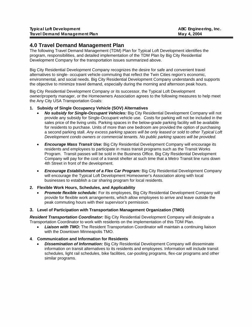
Typical Loft Development ABC Engineering, Inc. Travel Demand Management Plan May 4, 2004
4.0 Travel Demand Management Plan The following Travel Demand Management (TDM) Plan for Typical Loft Development identifies the program, responsibilities, and detailed implementation of the TDM Plan by Big City Residential Development Company for the transportation issues summarized above.
Big City Residential Development Company recognizes the desire for safe and convenient travel alternatives to single- occupant vehicle commuting that reflect the Twin Cities region’s economic, environmental, and social needs. Big City Residential Development Company understands and supports the objective to minimize travel demand, especially during the morning and afternoon peak hours.
Big City Residential Development Company or its successor, the Typical Loft Development owner/property manager, or the Homeowners Association agrees to the following measures to help meet the Any City USA Transportation Goals:
1. Subsidy of Single Occupancy Vehicle (SOV) Alternatives • No subsidy for Single-Occupant Vehicles: Big City Residential Development Company will not
provide any subsidy for Single-Occupant vehicle use. Costs for parking will not be included in the sales price of the living units. Parking spaces in the below-grade parking facility will be available for residents to purchase. Units of more than one bedroom are provided the option of purchasing a second parking stall. Any excess parking spaces will be only leased or sold to other Typical Loft Development condo owners or commercial tenants. No public parking spaces will be provided.
• Encourage Mass Transit Use: Big City Residential Development Company will encourage its residents and employees to participate in mass transit programs such as the Transit Works Program. Transit passes will be sold in the Business Office. Big City Residential Development Company will pay for the cost of a transit shelter at such time that a Metro Transit line runs down 4th Street in front of the development.
• Encourage Establishment of a Flex Car Program: Big City Residential Development Company will encourage the Typical Loft Development Homeowner’s Association along with local businesses to establish a car sharing program for local residents.
2. Flexible Work Hours, Schedules, and Applicability • Promote flexible schedule: For its employees, Big City Residential Development Company will
provide for flexible work arrangements, which allow employees to arrive and leave outside the peak commuting hours with their supervisor’s permission.
3. Level of Participation with Transportation Management Organization (TMO) Resident Transportation Coordinator: Big City Residential Development Company will designate a Transportation Coordinator to work with residents on the implementation of this TDM Plan.
• Liaison with TMO: The Resident Transportation Coordinator will maintain a continuing liaison with the Downtown Minneapolis TMO.
4. Communication and Information for Residents • Dissemination of Information: Big City Residential Development Company will disseminate
information on transit alternatives to its residents and employees. Information will include transit schedules, light rail schedules, bike facilities, car-pooling programs, flex-car programs and other similar programs.

Typical Loft Development ABC Engineering, Inc. Travel Demand Management Plan May 4, 2004
• Information for existing and new employees and residents: Big City Residential Development Company will make the Commuter Choice packet available, which includes a brochure on transportation options.
• Commuter Information Program: With assistance from Commuter Connection, Any City USA Transit, and Any City USA Commuter Services, Big City Residential Development Company will develop a commuter information program to familiarize residents and employees with the variety of available transportation resources.
• Move-in Packages: Big City Residential Development Company will create and implement a “move-in” transportation alternatives package for new residents and employees.
5. On-Site Sales of Transit Passes • Sale of Transit Passes: Big City Residential Development Company will make available transit
passes through the Transit Works program, and will provide a convenient location in the building for these sales.
6. Encourage the Use of Light Rail Transit • As part of the information programs on transit use, Big City Residential Development Company
will provide information to residents and employees to encourage the use Any City USA Bus Transit service.
7. Telecommuting and Teleconferencing • Telecommuting and Teleconferencing If and where feasible, Big City Residential Development
Company will provide residents and employees with information relating to telecommuting and teleconferencing. All residents will have the option of subscribing to high speed internet access.
8. Bicycle Facilities • Bicycle Storage: Big City Residential Development Company will provide secure bicycle storage
in the below- grade parking facility. One bicycle parking space will be available for each residential unit.
9. Off-peak truck and Service Scheduling • Off-peak scheduling: Big City Residential Development Company will encourage truck and
service vehicles, not including small package deliveries, to access the site outside of the weekday a.m. and p.m. peak traffic periods. Service Vehicle Loading/Unloading: All service vehicles will load and unload within the site. No on-street space will be allocated for service deliveries on the block. Moving in and out (loading/unloading) of the 710 Typical Loft Development building will be allowed if in compliance with all Any City USA parking statutes. Moving in and out (loading/unloading) of the 720 and 730 Typical Loft Development buildings will be accommodated with an on-site parking deck.
10. Monitoring of Travel Behavior • Original Survey: With the assistance of the Any City USA Downtown TMO, Typical Loft
Development will develop a methodology for surveying the travel behavior of a sample of its residents, once the entire development (Phase 1 and Phase 2) is 70% occupied.
• Ongoing Surveys: The condominium association will be requested to conduct a similar sampling every two years after the original baseline survey with assistance from the Any City USA Downtown TMO and continuing for a time period that will be determined jointly with the Any City USA Planning and Public Works Department.
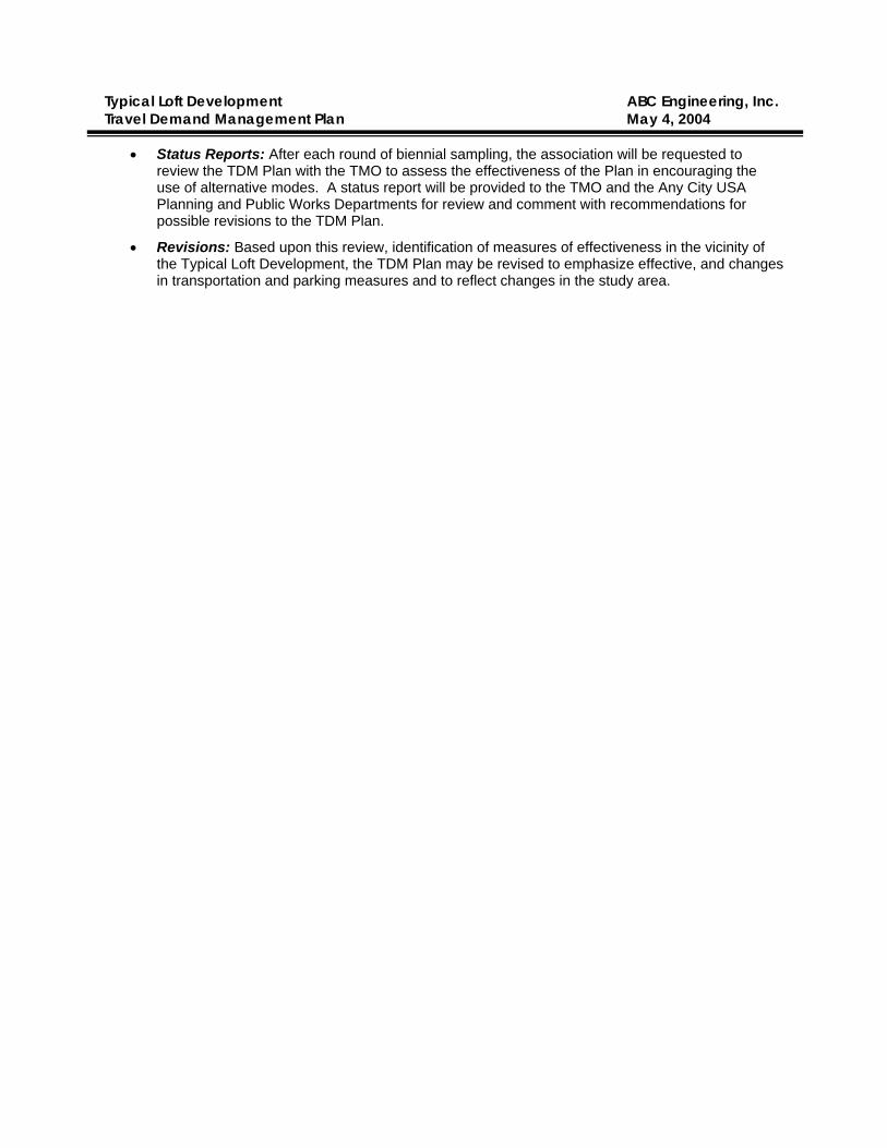
Typical Loft Development ABC Engineering, Inc. Travel Demand Management Plan May 4, 2004
• Status Reports: After each round of biennial sampling, the association will be requested to review the TDM Plan with the TMO to assess the effectiveness of the Plan in encouraging the use of alternative modes. A status report will be provided to the TMO and the Any City USA Planning and Public Works Departments for review and comment with recommendations for possible revisions to the TDM Plan.
• Revisions: Based upon this review, identification of measures of effectiveness in the vicinity of the Typical Loft Development, the TDM Plan may be revised to emphasize effective, and changes in transportation and parking measures and to reflect changes in the study area.