Embed Size (px)
Citation preview
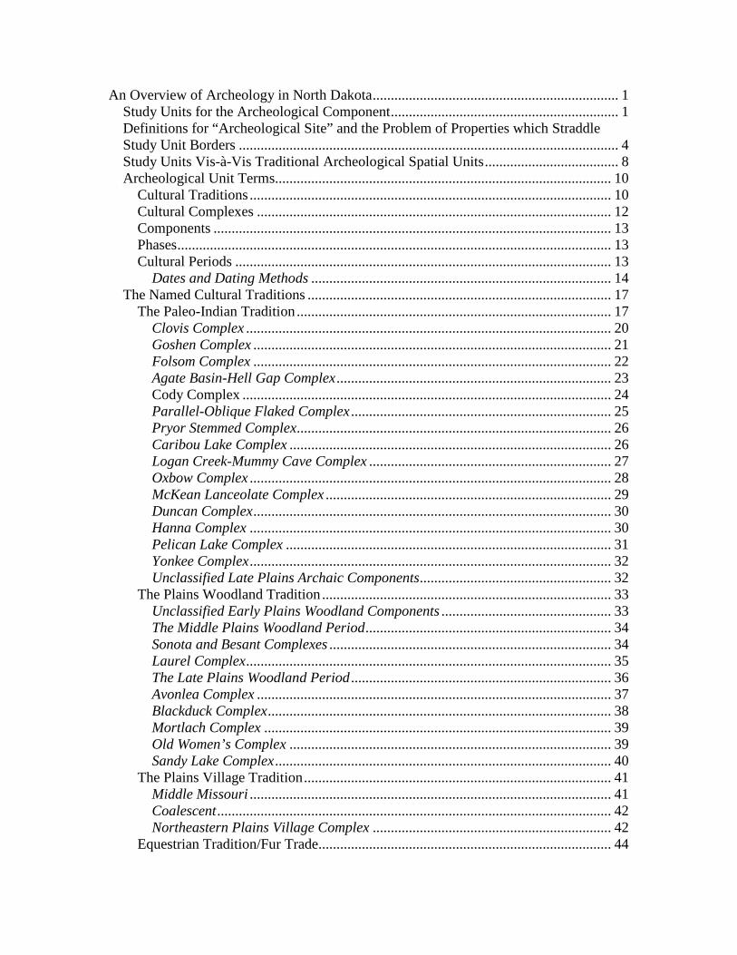
An Overview of Archeology in North Dakota .................................................................... 1 Study Units for the Archeological Component ............................................................... 1 Definitions for “Archeological Site” and the Problem of Properties which Straddle Study Unit Borders ......................................................................................................... 4 Study Units Vis-à-Vis Traditional Archeological Spatial Units ..................................... 8 Archeological Unit Terms............................................................................................. 10
Cultural Traditions .................................................................................................... 10 Cultural Complexes .................................................................................................. 12 Components .............................................................................................................. 13 Phases ........................................................................................................................ 13 Cultural Periods ........................................................................................................ 13
Dates and Dating Methods ................................................................................... 14 The Named Cultural Traditions .................................................................................... 17
The Paleo-Indian Tradition ....................................................................................... 17 Clovis Complex ..................................................................................................... 20 Goshen Complex ................................................................................................... 21 Folsom Complex ................................................................................................... 22 Agate Basin-Hell Gap Complex ............................................................................ 23 Cody Complex ...................................................................................................... 24 Parallel-Oblique Flaked Complex ........................................................................ 25 Pryor Stemmed Complex....................................................................................... 26 Caribou Lake Complex ......................................................................................... 26 Logan Creek-Mummy Cave Complex ................................................................... 27 Oxbow Complex .................................................................................................... 28 McKean Lanceolate Complex ............................................................................... 29 Duncan Complex ................................................................................................... 30 Hanna Complex .................................................................................................... 30 Pelican Lake Complex .......................................................................................... 31 Yonkee Complex .................................................................................................... 32 Unclassified Late Plains Archaic Components..................................................... 32
The Plains Woodland Tradition ................................................................................ 33 Unclassified Early Plains Woodland Components ............................................... 33 The Middle Plains Woodland Period .................................................................... 34 Sonota and Besant Complexes .............................................................................. 34 Laurel Complex ..................................................................................................... 35 The Late Plains Woodland Period ........................................................................ 36 Avonlea Complex .................................................................................................. 37 Blackduck Complex ............................................................................................... 38 Mortlach Complex ................................................................................................ 39 Old Women’s Complex ......................................................................................... 39 Sandy Lake Complex ............................................................................................. 40
The Plains Village Tradition ..................................................................................... 41 Middle Missouri .................................................................................................... 41 Coalescent ............................................................................................................. 42 Northeastern Plains Village Complex .................................................................. 42
Equestrian Tradition/Fur Trade................................................................................. 44
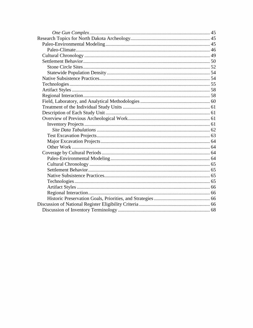
One Gun Complex ................................................................................................. 45 Research Topics for North Dakota Archeology................................................................ 45
Paleo-Environmental Modeling .................................................................................... 45 Paleo-Climate ............................................................................................................ 46
Cultural Chronology ..................................................................................................... 49 Settlement Behavior ...................................................................................................... 50
Stone Circle Sites ...................................................................................................... 52 Statewide Population Density ................................................................................... 54
Native Subsistence Practices......................................................................................... 54 Technologies ................................................................................................................. 55 Artifact Styles ............................................................................................................... 58 Regional Interaction ...................................................................................................... 58 Field, Laboratory, and Analytical Methodologies ........................................................ 60 Treatment of the Individual Study Units ...................................................................... 61 Description of Each Study Unit .................................................................................... 61 Overview of Previous Archeological Work .................................................................. 61
Inventory Projects ..................................................................................................... 61 Site Data Tabulations ........................................................................................... 62
Test Excavation Projects ........................................................................................... 63 Major Excavation Projects ........................................................................................ 64 Other Work ............................................................................................................... 64
Coverage by Cultural Periods ....................................................................................... 64 Paleo-Environmental Modeling ................................................................................ 64 Cultural Chronology ................................................................................................. 65 Settlement Behavior .................................................................................................. 65 Native Subsistence Practices..................................................................................... 65 Technologies ............................................................................................................. 65 Artifact Styles ........................................................................................................... 66 Regional Interaction .................................................................................................. 66 Historic Preservation Goals, Priorities, and Strategies ............................................. 66
Discussion of National Register Eligibility Criteria ......................................................... 66 Discussion of Inventory Terminology .......................................................................... 68
B.1
Archeology Component of the State Plan: An Overview of Archeology in North Dakota
Michael L. Gregg, Paul R. Picha, Fern E. Swenson, and Amy C. Bleier
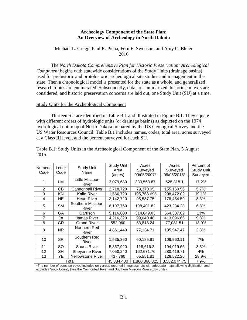
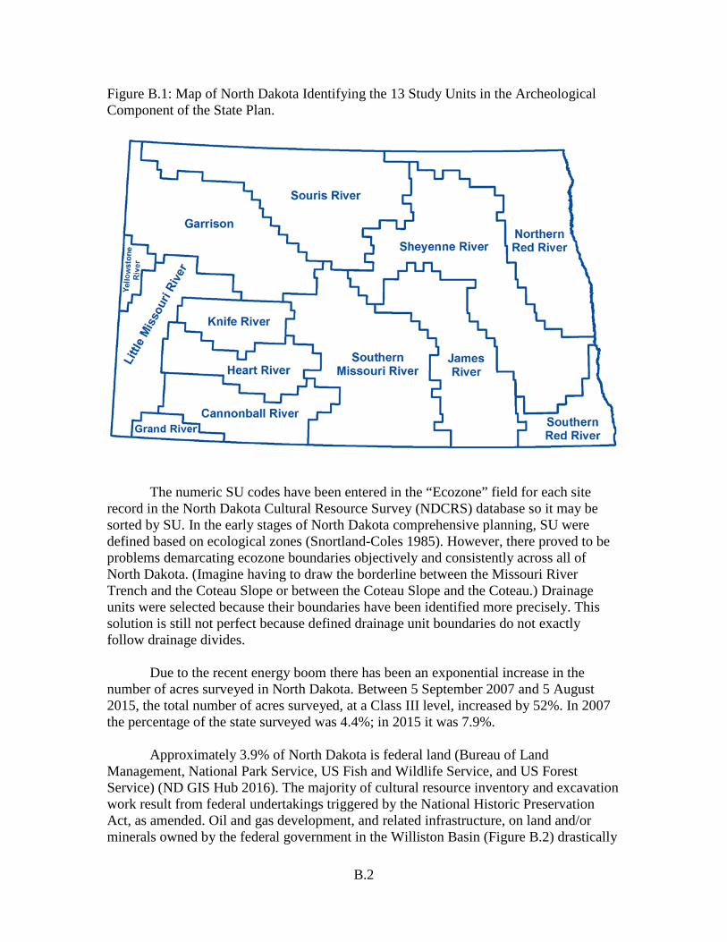
2016 The North Dakota Comprehensive Plan for Historic Preservation: Archeological Component begins with statewide considerations of the Study Units (drainage basins) used for prehistoric and protohistoric archeological site studies and management in the state. Then a chronological model is presented for the state as a whole, and generalized research topics are enumerated. Subsequently, data are summarized, historic contexts are considered, and historic preservation concerns are laid out, one Study Unit (SU) at a time. Study Units for the Archeological Component Thirteen SU are identified in Table B.1 and illustrated in Figure B.1. They equate with different orders of hydrologic units (or drainage basins) as depicted on the 1974 hydrological unit map of North Dakota prepared by the US Geological Survey and the US Water Resources Council. Table B.1 includes names, codes, total area, acres surveyed at a Class III level, and the percent surveyed for each SU. Table B.1: Study Units in the Archeological Component of the State Plan, 5 August 2015. Numeric
Code Letter Code
Study Unit Name
Study Unit Area
(acres)
Acres Surveyed
09/05/2007*
Acres Surveyed
08/05/2015*
Percent of Study Unit Surveyed
1 LM Little Missouri River 3,079,680 339,563.87 528,318.1 17.2%
2 CB Cannonball River 2,718,720 79,370.05 155,160.56 5.7% 3 KN Knife River 1,566,720 195,768.695 298,472.02 19.1% 4 HE Heart River 2,142,720 95,587.75 178,454.59 8.3%
5 SM Southern Missouri River 6,197,760 198,401.82 423,284.28 6.8%
6 GA Garrison 5,116,800 314,649.03 664,337.82 13% 7 JA James River 4,216,320 99,040.48 413,096.66 9.8% 8 GR Grand River 552,960 53,818.24 77,081.51 13.9%
9 NR Northern Red River 4,861,440 77,134.71 135,947.47 2.8%
10 SR Southern Red River 1,535,360 60,185.91 106,960.11 7%
11 SO Souris River 5,857,920 118,616.2 194,019.66 3.3% 12 SH Sheyenne River 7,050,240 162,671.76 280,419.71 4% 13 YE Yellowstone River 437,760 65,551.81 126,522.26 28.9%
Total 45,334,400 1,860,360.325 3,582,074.75 7.9% *The number of acres surveyed includes only areas reported in manuscripts with adequate maps allowing digitization and excludes Sioux County (see the Cannonball River and Southern Missouri River study units).
B.2
Figure B.1: Map of North Dakota Identifying the 13 Study Units in the Archeological Component of the State Plan.
The numeric SU codes have been entered in the “Ecozone” field for each site record in the North Dakota Cultural Resource Survey (NDCRS) database so it may be sorted by SU. In the early stages of North Dakota comprehensive planning, SU were defined based on ecological zones (Snortland-Coles 1985). However, there proved to be problems demarcating ecozone boundaries objectively and consistently across all of North Dakota. (Imagine having to draw the borderline between the Missouri River Trench and the Coteau Slope or between the Coteau Slope and the Coteau.) Drainage units were selected because their boundaries have been identified more precisely. This solution is still not perfect because defined drainage unit boundaries do not exactly follow drainage divides. Due to the recent energy boom there has been an exponential increase in the number of acres surveyed in North Dakota. Between 5 September 2007 and 5 August 2015, the total number of acres surveyed, at a Class III level, increased by 52%. In 2007 the percentage of the state surveyed was 4.4%; in 2015 it was 7.9%. Approximately 3.9% of North Dakota is federal land (Bureau of Land Management, National Park Service, US Fish and Wildlife Service, and US Forest Service) (ND GIS Hub 2016). The majority of cultural resource inventory and excavation work result from federal undertakings triggered by the National Historic Preservation Act, as amended. Oil and gas development, and related infrastructure, on land and/or minerals owned by the federal government in the Williston Basin (Figure B.2) drastically

B.3
increased in 2008. Falling oil prices significantly slowed production in 2015. In general, site avoidance, rather than testing and/or mitigation, has been the choice of applicants. This has resulted in initial documentation of many new sites but relatively few evaluative investigations (Table B.2). Large inventories and testing and major excavations for each SU are detailed in the following chapters.
Figure B.2: Shaded Areas of the Map Represent the Williston Basin in North Dakota.
Table B.2: Summary of Recorded Sites, Formally Tested, and Major Excavations by Study Unit, 5 August 2015.
Study Unit (Numeric Code, Name,
and Letter Code)
Percent of Study Unit Surveyed
One Site Per Square Mile
Number of
Recorded Sites
Sites Formally Tested
Sites Mitigated or Major Research Project
(1) Little Missouri River (LM) 17.2% 1.98 mi² 2,410 174 15
(2) Cannonball River (CB) 5.7% 12.2 mi² 343 5 0 (3) Knife River (KN) 19.1% 1.2 mi² 1,979 413 49 (4) Heart River (HE) 8.3% 5.7 mi² 582 70 3 (5) Southern Missouri River (SM) 6.8% 6.5 mi² 1,482 319 72 (6) Garrison (GA) 13% 1.9 mi² 4,156 164 60 (7) James River (JA) 9.8% 9.5 mi² 690 59 19 (8) Grand River (GR) 13.9% 3.1 mi² 142 7 2 (9) Northern Red River (NR) 2.8% 28.1 mi² 270 38 3 (10) Southern Red River (SR) 7% 40.6 mi² 59 14 3 (11) Souris River (SO) 3.3% 29.5 mi² 309 28 2 (12) Sheyenne River (SH) 4% 13.1 mi² 841 168 16 (13) Yellowstone River (YE) 28.9% 2.1 mi² 365 18 3
B.4
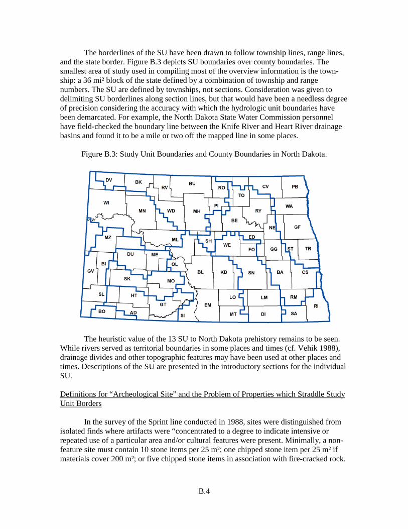
The borderlines of the SU have been drawn to follow township lines, range lines, and the state border. Figure B.3 depicts SU boundaries over county boundaries. The smallest area of study used in compiling most of the overview information is the town-ship: a 36 mi² block of the state defined by a combination of township and range numbers. The SU are defined by townships, not sections. Consideration was given to delimiting SU borderlines along section lines, but that would have been a needless degree of precision considering the accuracy with which the hydrologic unit boundaries have been demarcated. For example, the North Dakota State Water Commission personnel have field-checked the boundary line between the Knife River and Heart River drainage basins and found it to be a mile or two off the mapped line in some places.
Figure B.3: Study Unit Boundaries and County Boundaries in North Dakota.
The heuristic value of the 13 SU to North Dakota prehistory remains to be seen. While rivers served as territorial boundaries in some places and times (cf. Vehik 1988), drainage divides and other topographic features may have been used at other places and times. Descriptions of the SU are presented in the introductory sections for the individual SU. Definitions for “Archeological Site” and the Problem of Properties which Straddle Study Unit Borders In the survey of the Sprint line conducted in 1988, sites were distinguished from isolated finds where artifacts were “concentrated to a degree to indicate intensive or repeated use of a particular area and/or cultural features were present. Minimally, a non-feature site must contain 10 stone items per 25 m²; one chipped stone item per 25 m² if materials cover 200 m²; or five chipped stone items in association with fire-cracked rock.

B.5
When vegetative cover was dense, the quantitative thresholds were lowered” (Deaver and Deaver 1988:3). For the Northern Border Pipeline transects survey, three kinds of artifact deposits were identified: (1) archeological sites, (2) find spots, and (3) modern debris (Root 1983w:553-556). Modern debris was defined to include things less than 50 years old. Find spots were places where five or fewer artifacts were observed or otherwise documented in an area of about 1 ha (10,000 m² or 2.45 acres). “The criterion of five artifacts as the threshold between find spots and archeological sites has no conceptual basis in…behavioral terms. It is merely a convenient, low number. In other words, the only difference between most find spots with five artifacts and an archeological site from which six artifacts were recovered is one artifact” (ibid.:556). Sites were further described as places which:
(1) contain six or more prehistoric artifacts with a density of at least 6/ha that are not demonstrably in a secondary deposit, (2) contain at least one historic or prehistoric feature, (3) contain at least six historic artifacts with a density of at least 6/ha, not demonstrably in a secondary deposit, or (4) contain intact, subsurface, cultural deposit, regardless of the number of documented artifacts. If artifact concentrations are separated by physiographic boundaries, such as intermittent stream channels, they are assigned separate site numbers. If, however, two or more concentrations are connected by an intervening area of lower artifact density, they are assigned one site number. The site is then divided into subareas which correspond with concentrations and/or topographically delimited areas of the site (Root 1983w:556).
Sites with boundaries that cross over township or range lines between two SU are considered as cases in both SU. Additional information is available in the NDCRS Site Form Training Manual: Archeological Sites (Snortland et al. 2015).
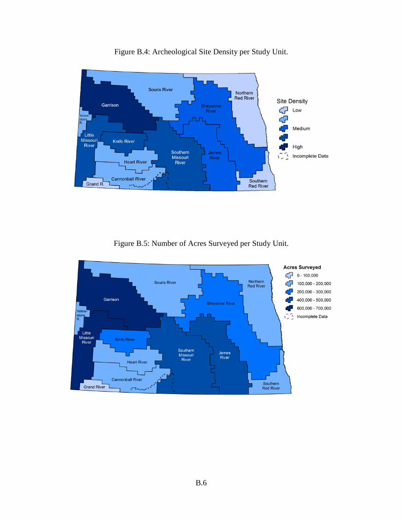
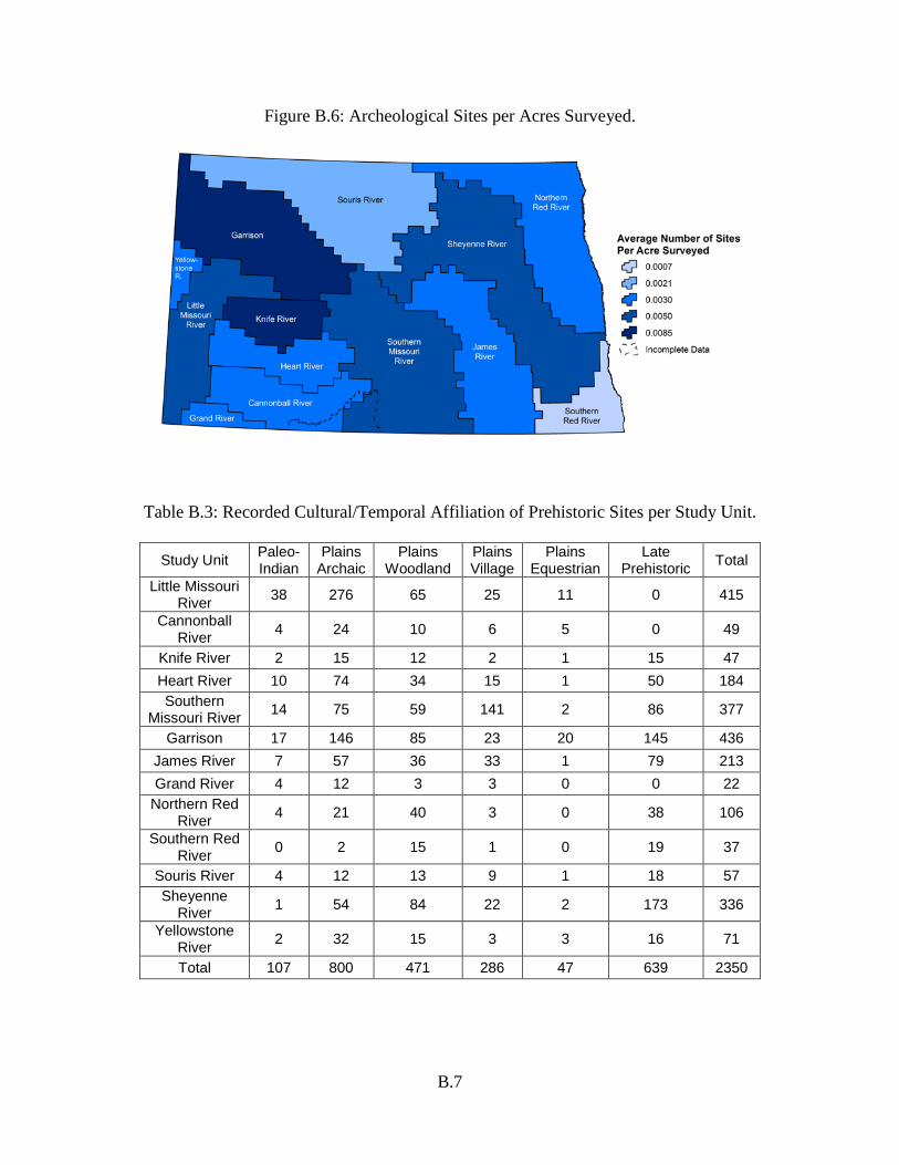
The following four figures depict data on record in NDCRS as of August 5, 2015. The data include information coded for archeological sites only, not site leads or isolated finds. The data for Sioux County are incomplete (see the Cannonball River and Southern Missouri River SU for more information). The figures were created using ArcGIS. The data in the first three figures were divided into classes and labeled with relative terms (low, medium, high). In Figure B.4, the density of archeological sites was derived by dividing the number of archeological sites by area per SU. Figure B.5 depicts the number of acres surveyed for each SU. The data illustrated in Figure B.6 were derived by dividing the number of recorded archeological sites per acres surveyed. Table B.3 shows the number of archeological sites coded for “cultural/temporal affiliation” on the NDCRS forms. See succeeding sections of this chapter for a detailed discussion of cultural/temporal affiliation.
B.6
Figure B.4: Archeological Site Density per Study Unit.
Figure B.5: Number of Acres Surveyed per Study Unit.
B.7
Figure B.6: Archeological Sites per Acres Surveyed.
Table B.3: Recorded Cultural/Temporal Affiliation of Prehistoric Sites per Study Unit.
Study Unit Paleo-
Indian Plains
Archaic Plains
Woodland Plains Village
Plains Equestrian
Late Prehistoric Total
Little Missouri River 38 276 65 25 11 0 415
Cannonball River 4 24 10 6 5 0 49
Knife River 2 15 12 2 1 15 47 Heart River 10 74 34 15 1 50 184 Southern
Missouri River 14 75 59 141 2 86 377
Garrison 17 146 85 23 20 145 436 James River 7 57 36 33 1 79 213 Grand River 4 12 3 3 0 0 22
Northern Red River 4 21 40 3 0 38 106
Southern Red River 0 2 15 1 0 19 37
Souris River 4 12 13 9 1 18 57 Sheyenne
River 1 54 84 22 2 173 336
Yellowstone River 2 32 15 3 3 16 71
Total 107 800 471 286 47 639 2350
B.8
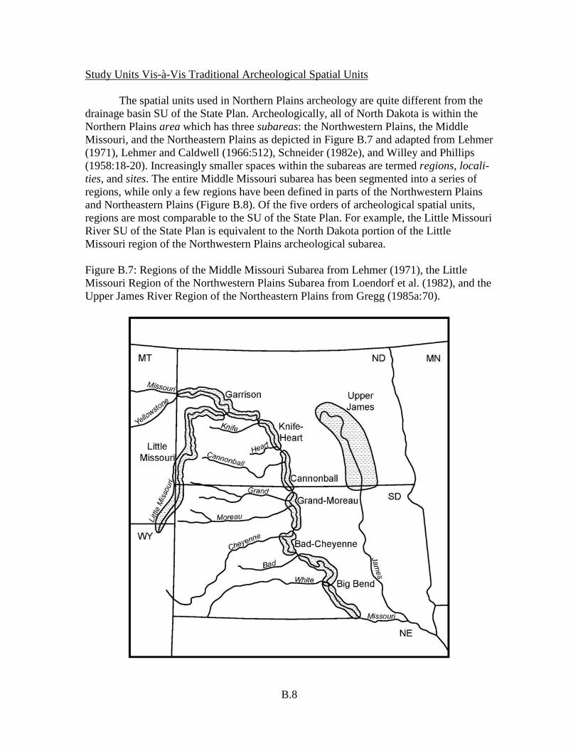
Study Units Vis-à-Vis Traditional Archeological Spatial Units The spatial units used in Northern Plains archeology are quite different from the drainage basin SU of the State Plan. Archeologically, all of North Dakota is within the Northern Plains area which has three subareas: the Northwestern Plains, the Middle Missouri, and the Northeastern Plains as depicted in Figure B.7 and adapted from Lehmer (1971), Lehmer and Caldwell (1966:512), Schneider (1982e), and Willey and Phillips (1958:18-20). Increasingly smaller spaces within the subareas are termed regions, locali-ties, and sites. The entire Middle Missouri subarea has been segmented into a series of regions, while only a few regions have been defined in parts of the Northwestern Plains and Northeastern Plains (Figure B.8). Of the five orders of archeological spatial units, regions are most comparable to the SU of the State Plan. For example, the Little Missouri River SU of the State Plan is equivalent to the North Dakota portion of the Little Missouri region of the Northwestern Plains archeological subarea. Figure B.7: Regions of the Middle Missouri Subarea from Lehmer (1971), the Little Missouri Region of the Northwestern Plains Subarea from Loendorf et al. (1982), and the Upper James River Region of the Northeastern Plains from Gregg (1985a:70).

B.9
Figure B.8: Archeological Subareas of the Northern Plains Combining Terminology from Griffin (1952), Lehmer (1971:28-29), Lehmer and Caldwell (1966:512), and Wedel (1961:23), after Gregg (1985a:68).
B.10
A Chronological Model for North Dakota Archeology A chronological model in archeology is a classificatory framework used to specify the ages and “cultural affiliations” of archeological remains. During the initial formulation of the State Plan, one general chronological model was proposed to serve for the entire state in dealing with gross temporal scaling and archeological identification. The terms employed in the general chronology, as illustrated in Figure B.9, are drawn from other chronologies used in the Northwestern Plains (Frison 1978), Middle Missouri (Lehmer 1971), and Northeastern Plains (Gregg et al. 1987) archeological subareas. Specific chronological models are treated or cited in some of the individual SU sections. Those more detailed chronologies ought to be employed in approaching specific problems in those areas. For example, a narrowly defined context such as proto-Hidatsa settlement in the Knife River-Missouri River confluence locality should utilize the more specific model developed for the Knife River Indian Villages National Historic Site (cf. Ahler 1988, 1993; Ahler and Kay 2007; Johnson 2007). Similarly, Mandan settlement at the Heart River–Missouri River confluence locality utilizes existing data (Ahler 2007; Mitchell Swenson 2007) Archeological Unit Terms Different chronological classifications use standardized sets of archeological unit terms, but terminology usually varies between chronologies. The generalized statewide model employs the terms “cultural tradition,” “cultural complex,” and “cultural period.” Other models use terms such as pattern, stage, variant, phase, aggregate, focus, and composite. The definitions of all of these terms involve some kind of cultural content (diagnostic or typical artifacts and features), geographic distribution, and temporal duration. Some of the terms are general and serve to identify broad cultural patterns that endured for long periods of time over expansive geographic areas. Others are specific. The following subsections cover the archeological unit terms used in the statewide model. Some other commonly encountered terms are discussed as well. Cultural Traditions Cultural traditions are lifeways or general adaptive strategies defined in terms of variation in reliance upon hunting, gathering, and gardening for food production, the subsistence resources exploited, and the use of ceramic containers for cooking and food processing. Paleo-Indian (Paleo) lifeways were based on hunting and gathering adaptations to early Holocene climates, plants, and animals. Plains Archaic lifeways, like Paleo lifeways, were based on hunting and gathering adaptations, but the adaptations were to changing Holocene resource bases. The Plains Archaic tradition, as presently defined for North Dakota, did not involve gardening or the use of pottery. The Plains Woodland tradition was primarily based upon hunting and gathering, but sometimes involved gardening and the production and use of ceramic vessels. In the Plains Village adaptive strategy, food production typically involved hunting, gathering, and gardening, and ceramic vessels were commonly produced and used in everyday life. The Equestrian
B.11
Figure B.9: General Chronology as Discussed in the State Plan.
Cultural Periods Years AD - BC
Cultural Traditions Cultural Complex
Equestrian Nomadic
Plains Village
Plains Woodland
Plains Archaic
Paleo-Indian
One Gun
Knife River Heart River Painted Woods Middle Missouri Shea Northeastern Plains Devils Lake/Sourisford Charred Body
Sandy Lake Blackduck Kathio Arvilla
Avonlea Laurel Besant Sonota Unnamed Early Woodland Pelican Lake Yonkee Hanna Duncan McKean Lanceolate Oxbow Hawken Logan Creek Caribou Lake Pryor Stemmed Parallel-Oblique Flaked Cody Hell Gap Agate Basin Folsom Goshen Clovis
Equestrian/Fur Trade 1780 - 1880
Plains Village AD 1200 - 1780
Late Plains Woodland
AD 600 - 1200
Middle Plains Woodland
100 BC – AD 600
Early Plains Woodland 400 – 100 BC
Late Plains Archaic
1000 – 400 BC
Middle Plains Archaic
2800 – 1000 BC
Early Plains Archaic
5500 – 2800 BC
Paleo-Indian
9500 – 5500 BC
1780
1500
500
1000
750
250
0
250
500
750
1000
2000
3000
4000
5000
6000
7000
8000
9000
1250
B.12
lifeway was a hunting and gathering adaptation that appears to have been at times more narrowly focused on bison than prior hunting and gathering adaptations. It was a lifeway dependent upon the use of horses to perform work. Some Anthropologists equate cultural traditions with stages of cultural development and view the transition from Paleo to Plains Archaic to Plains Woodland to Plains Village as a four-stage developmental sequence. Others see two stages of prehistoric cultural development on the Plains: foraging and village agriculture (Michlovic 1986b:214). Contemporaneous groups of people could have been found living different lifeways in different parts of the state at most times during prehistory, especially during the Plains Woodland and Plains Village periods. This perspective is fostered by the illustration of the chronological model where boundaries between named units are dashed and time transgressive. Cultural traditions do not necessarily equate with tribes or other social groups. Sometimes, as documented ethnographically, groups with different adaptive strategies may have been from a single society or of one ethnic affiliation. Conversely, coeval groups from different societies could be found living similarly in different parts of the state. The times when lifeways such as Plains Woodland and Plains Village originated and terminated varied across the state. For example, lifeways involving significant reliance on gardening are suggested to have become dominant in southeastern North Dakota several centuries earlier than they did in the central and western parts of the state. Also, the dates of origin and termination for traditions, just as with other named archeological units, tend to shift somewhat as (1) more artifact deposits are dated, (2) dating procedures are improved, and (3) the calibration of radiocarbon dates to calendar dates is refined. In the Southern Missouri River SU, investigations at Menoken State Historic Site (Ahler 2007) indicate a transition from a Plains Woodland to Plains Village lifeway in the early AD 1200s. Cultural Complexes Cultural complexes are groups of similar and distinctive material remains that have been found at numerous sites in an area or subarea. This is nearly the same as defining a complex as “a homogeneous series of diagnostic artifact types with known temporal and spatial parameters” (Burley et al. 1982:45). The material remains which typify a particular cultural complex usually include technologically and stylistically diagnostic artifacts such as ceramic wares, point types, and unique mortuary offerings, and they sometimes comprise distinctive settlement traits such as particular kinds of residential lodges or cache features. A complex in this sense is similar to a “composite” as defined by Syms (1977:71) and employed by Meyer and Russell (1987:4) among others. A “complex” in Syms’ (1977:70) terminology identifies material remains left “by the same group” which is not the case here.

B.13
A number of different components attributable to a particular complex need to be investigated in order to gain some understanding of the range of settlement types, subsistence practices, artifact styles, and feature types represented. However, the mere find of a particular style of projectile point or pottery vessel is indicative of some sort of representation of people with a certain artifact complex in a SU even though a large artifact sample or series of sites has not been documented. Components A component is a deposit of artifacts and features representative of one cultural complex at a single site. The deposit may have resulted from one occupation or multiple occupations. It might have involved one group or several groups. The period of time involved in the deposition of a component is so brief that only a single cultural zone or stratum is typically present. Sometimes, however, two or more cultural zones in a stratified site may be assigned to the same component for analytical purposes if they are attributable to the same cultural complex. There is usually less information potential in sites with mixed components than in sites where all of the artifacts and features encountered can be reliably attributed to one component. A component as defined here is similar to “assemblage” as defined by Syms. But he reserves the term assemblage to identify the material remains of “a single residential group” (Syms 1977:70). It is rare for an intact cultural zone in an archeological site to be identified with certainty as the remains of a single episode of occupation by one group. Phases A phase is a regional expression of a particular cultural tradition and cultural complex. A phase is defined based on activities representative of one lifeway and material traits characteristic of one cultural complex. The definition involves components from within a geographic area no larger than the size of an archeological region (cf. Willey and Phillips 1958:22). The duration of a phase is typically hundreds of years, not tens of thousands. Phases are the most important classificatory units used in building specific chronological models for regions. Variant is a term central to Lehmer’s (1971:32; Krause 1998:61-63) chronology for the Plains Village tradition in the Middle Missouri subarea. Components that are assigned to a particular variant are all representative of one cultural tradition and one cultural complex. The difference between a variant and a phase is that components assigned to a variant cover a geographic area larger than an archeological region. For example, Extended Middle Missouri variant sites are spread over many archeological regions within the Middle Missouri and Northwestern Plains subareas. Cultural Periods Cultural periods are simply segments of the time scale. Their utility is for reference to general blocks of time. The periods in the general North Dakota chronology
B.14
are named for the ways of life thought to have dominated the cultural scene in the state at the time. The Paleo period (9500-5500 BC) covers the time from the initial entry of man into North Dakota until the time when Plains Archaic lifeways superseded Paleo adaptations as dominant in North Dakota. The Plains Village period (AD 1200-1780) begins with the first occurrence of Plains Village adaptations in the state and endures until the time when the Villages were decimated by the 1780 epidemics after which the nomadic Sioux became the dominant cultural force in the Northern Plains. The Equestrian period (1780-1880) terminates with the surrender of Sitting Bull at Fort Buford in the Yellowstone SU. Lehmer (1971:32) defined an Equestrian period in his chronology for the Middle Missouri subarea. In an area the size of North Dakota, it is expected that at times in prehistory, there were different ways of life ongoing contemporaneously. Two thousand years ago, for instance, settled communities may have been characteristic of the James River region, but they may have been unknown in the Little Missouri region. Date ranges for periods in chronologies for smaller geographic areas such as regions or localities should be expected to vary somewhat from the statewide chronology. A lifeway can change faster in an area the size of an archeological locality than in an archeological subarea simply because of the likelihood of historic events or processes to affect everyone in a small area. So, the beginning date of a period may be earlier for a locality where a new way of life originated than for the state as a whole. The term “late prehistoric period” is used generically to identify sites or components with arrow points and/or thin undecorated pottery sherds. In most parts of the state, analytical procedures have not yet been devised for distinguishing between arrow points made during the Late Plains Woodland and Plains Village periods. Thin undecorated pottery sherds have also been found at sites occupied during both periods. The term “late prehistoric period” used in the State Plan is not equivalent to the Late Prehistoric period (with initial caps) of Northwestern Plains cultural chronologies (cf. Frison 1978; Mulloy 1958). Dates and Dating Methods Beginning and ending dates for periods and other named archeological units result from the application of one or more chronometric or relative dating techniques. Chronometric dating techniques yield actual calendar age estimates within specified limits of confidence. Relative dating techniques yield general age estimates calculated with reference to other chronometrically or relatively dated samples. Chronometric dating techniques that have been applied to archeological remains from the state include (1) dendrochronology, (2) thermoluminescence analysis, (3) obsidian hydration rim analysis, and (4) radiocarbon analysis. See Nash (2000) for an overview of methods. Dendrochronology, calculating the actual calendar age of an annual growth ring in a wood sample, is the most precise. Its application has been used at archeological sites in North Dakota, including: (1) bur oak samples from a few sites in

B.15
the Southern Missouri River SU (Caldwell and Snyder 1983; Will 1946) and (2) at the Biesterfeldt site (32RM1) in the Sheyenne River SU (Zeleznik 2015). Thermoluminescence (TL) has had a wider application in the state. Most TL dating has been done on samples from sites at the Knife River Indian Villages National Historic site (KNRI), but there are some TL dates from most of the SU. Confidence in TL dates is enhanced when there is a comparative sample of radiocarbon dates on organic remains from the TL dated contexts (cf. Ahler and Mehrer 1984:209-213). Obsidian hydration dating, based on the rate of hydration rim formation on a freshly exposed surface on a flaked obsidian artifact, has been used as a chronometric technique on North Dakota samples (Baugh and Nelson 1988). Rates of hydration vary dependent upon the chemical composition of the obsidian (which differs from source to source) and differences in the air and soil temperature and chemical characteristics of the archeological recovery context (Shackley 2005; Steffen 2005). There may be different hydration rates for the same material from different layers of artifacts in stratified sites (cf. Gregg and Swenson 1987:77). There are more radiocarbon dates than any other types of chronometric dates from North Dakota sites. Radiocarbon dating is based upon the rate of decay of radioactive 14C subsequent to the death of an organism or a part of an organism. 14C is a carbon isotope that is formed in the atmosphere and incorporated in living organisms along with stable 12C in normal development processes. Two important variations which must be accounted for in radiocarbon dating are differences through time for 14C in the atmosphere (calibration) and differences in 14C uptake between kinds of organisms (isotopic fractionation). Radiocarbon age determinations must be corrected to account for these variations if they are to be accurately related to Roman calendar dates. Raw radiocarbon age determinations are presented as uncorrected radiocarbon years before present (RCYBP). Raw dates are usually corrected for isotopic fractionation and then fractionation-corrected dates are calibrated to yield actual calendar dates. Prior to 1990, the most accurate calibration curves were those presented by Pearson and Stuiver (1986) and Stuiver and Pearson (1986). Multiple dates on multiple samples yield more reliable age determinations than solitary dates. There are a variety of techniques for comparing, clustering, or combining (averaging) multiple radiocarbon dates (cf. Long and Rippeteau 1974; Spaulding 1958; Ward and Wilson 1978; Wilson and Ward 1981). Whenever possible, presentations of specific radiocarbon dates in the historic contexts are identified by laboratory numbers and are accompanied with notations regarding corrections and calibrations. IntCal13 calibration program is available online (Reimer et al. 2013). Reporting of results should follow the guidelines provided. Radiocarbon assay of botanical remains is the most accurate method to yield absolute dates. Other recent information is presented in Bronk et al. (2013). Relative dating techniques are used to estimate the ages of individual artifacts, artifact deposits, and cultural features in relation to other dated remains. Cross dating, stratigraphic superposition, carbonate encrustation, and Knife River flint (KRF)
B.16
patination are four kinds of relative dating commonly employed in North Dakota archeology. Cross dating typically involves assessments of stylistic and technological attributes of artifacts and cultural features. It is based on the principle that artifacts and structures were often produced in conformance with apparent technological and/or stylistic standards which changed through time. Once such standards are chronometrically dated, their ages can be tentatively extended to other sites containing artifacts or features that are assessed as having been produced in accord with the dated standard. Cross dating that involves specific artifact styles or types is often referred to as typological dating. Stratigraphic superposition is the most fundamental of the relative dating techniques. It is based on the principle that each succeeding layer of cultural or non-cultural material (moving upward through a stratigraphic sequence) is more recent than the layer beneath it. The calendar ages of cultural deposits in a stratified sequence can sometimes be estimated if rates of sedimentation or accretion are known for a stratified sequence and if there are chronometric dates for some of the layers in the sequence. In some cases, dates of artifact deposits in central and western North Dakota have been estimated by determining their stratigraphic position within the known sequence of buried soils and undeveloped sediments of the Oahe Formation (cf. Clayton et al. 1976). The accuracy of this dating procedure will increase significantly as (1) time transgressive differences in the ages of specific soils are defined from east to west and from south to north across the state, and (2) all of the buried soils are identified and dated in various sedimentary contexts in different parts of the state. Carbonate encrustations form on artifacts and other items in buried deposits as calcium carbonate particles form and move downward through a soil profile. Crusts of carbonate typically form on the bottom sides of artifacts and increase in thickness with time. In some cases where artifacts from multiple occupations have aggraded within a single soil over a long period of time and it is not possible to use stratigraphic superposition to sort out the remains from the different occupations, variations in the thickness of carbonate rinds can be used to separate the older and younger materials. The development of patina on artifacts made from KRF and other materials such as some chalcedonies, cherts, and silicified sandstones tends to increase with time, dependent upon depositional contexts. Patination of KRF has been studied the most, and its rate appears to be greatest when artifacts lay at or near the ground surface and when soil conditions are alkaline (VanNest 1985b). An ordinal scale of patination intensity (absent, light, moderate, heavy, and heavy and eroded) has been applied to many KRF artifact samples of different ages from throughout the state. It has been proposed that a KRF artifact sample with at least 15-20% of the items having moderate or greater patina-tion intensity is at least 1,500 years old (Root et al. 1986:446). Knife River flint patination data serve best to assess the minimum ages of artifact samples and to explore possibilities for mixed components within a single deposit (ibid.).

B.17
The Named Cultural Traditions Parts of all of the SU apparently were occupied to some extent by peoples who lived Paleo, Plains Archaic, Plains Woodland, Plains Village, and Equestrian lifeways. The general characteristics of these adaptations are described below. Cultural complexes with components that are known or anticipated in any part of the state are described summarily by tradition. Aspects of cultural content, geographic extent and temporal duration are considered for each complex along with identification of some basic references. Occasionally, mention is made of particular sites within the state, but most references to specific North Dakota sites are found in the individual SU sections. This chronological modeling is incomplete and it contains inaccuracies. It will need to be modified, expanded and corrected as continuing archeological work produces additional useful information. This chronology is broad and not specific to any particular region or locality. It is intended to serve general chronological purposes throughout the state. Chronologies that are more particularistic are needed for most archeological work being conducted in specific archeological regions and localities. Regarding completeness, there have certainly been many archeological cultures that existed in prehistory that have not yet been identified. They can be added when they are identified. Another note of caution: multiple archeological cultures may be represented by some of the individual archeological units defined in the current model. For example, Initial Middle Missouri might be subdivided into Formative and Early Middle Missouri someday. The Paleo-Indian Tradition Components in the Northern Plains with artifacts and features attributable to cultural complexes of the Paleo tradition date from 9500-5500 BC or so, an era referred to as the Paleo period. This period is thought to cover the time from the initial peopling of the state until the transition of Paleo lifeways into Plains Archaic lifeways. (Pre-Paleo potentials are not considered.) Presumably, that transition period lasted for centuries, and had different characteristics in different areas. At the multi-component, stratified Cherokee site in northwestern Iowa, for example, there were no discernible differences between the Late Paleo and Early Plains Archaic artifact assemblages that would indicate any significant difference in the adaptive strategies involved (Anderson 1980:197; Anderson et al. 1980:257). In other places, ecological adaptations may have differed considerably. The Paleo tradition was characterized by hunting and gathering adaptations with a notable concentration on now-extinct big game animals. At the beginning, the focus of attention was on Pleistocene fauna such as mammoths and camels; later it was species of bison intermediate in size between late Pleistocene and modern forms (cf. Roberts 1940; Willey 1966:37-51). Other characteristics of the Paleo tradition include (1) geographically extensive interaction networks between social groups (Hayden 1982) and (2) distinctive lanceolate projectile point styles by which the various Paleo cultural complexes are identified.
B.18
Paleo poeples were the first hunter-gatherers in North Dakota based on current evidence. And while their food quest focused on the extraordinary big game animals of terminal Pleistocene/early Holocene time, like all subsequent Northern Plains hunter-gatherers, they gathered wild plant foods as well (cf. Agogino 1962:246; Fitting 1970:65). But less is known concerning the paleoethnobotany of Paleo people than that of later peoples of any of the other cultural traditions. Finds of Paleo artifacts are rare in the eastern half of the state, but not as rare in the northwestern part of the state. Some would say it is obvious that the most significant discoveries will be made where there are intact remnants of early Holocene landscape. The major obstacle to finding Paleo sites is locating those remnant landscapes and surveying them where they are exposed either on the surface or in erosional cuts. Most of the 10,000 year-old living surfaces have either been destroyed by erosion or deeply buried by alluvial or aeolian sedimentation. Holliday and Miller (2014) provide an update of the Clovis landscape. Prospects are best for finding Paleo sites in areas where intact early Holocene land surfaces are shallowly buried as in portions of the unglaciated Missouri Plateau and other upland grassland areas that were out from under glacial ice before the end of the Paleo period (Ahler 2003; Ahler et al. 2002; Root 1993; William 2000a). Most intact Paleo deposits documented through 2015 are in portions of the Knife River SU that have not been glaciated since Paleo people first entered the Northern Plains (cf. Artz 1988a; Root et al. 1986). However, in 1988 and 1989, salvage excavations were carried out at an artifact deposit radiocarbon dated ca. 7,000 BP shallowly buried in a small former glacial meltwater channel in the Northern Red River SU (Larson and Penny 1990). Paleo deposits documented in the Spring Creek valley in the Knife River SU are in similar contexts. Early Holocene playa areas also are likely spots. A playa setting in Stutsman County is the only place in North Dakota where the complete skeletal remains of a mammoth have been found (Smorada 1969). The Stutsman County mammoth find site was estimated to date around 10,000 BC. Although there were no artifacts found in association, the discovery supports the proposition that Pleistocene megafauna were present in North Dakota early in Paleo times. Portions of another mammoth skeleton were unearthed at Powers Lake in 1988 (Dan Aird, personal communication to Signe Snortland). No determination has been made with regard to possible Paleo activities associated with the carcass. In the valleys of the state’s medium-sized rivers which once carried glacial meltwaters, such as the James and Souris and Sheyenne, early Holocene surfaces that hold Paleo cultural deposits are buried tens and scores of meters below present-day floodplain surfaces and beneath the water table. Those valleys were cut by torrents of glacial meltwater when the last glaciers receded northward. The valley cuts were extremely deep, and the valley walls were steep-sided. Deglaciated terrain was probably re-vegetated rather quickly under the still-mesic environmental conditions of the Late Glacial and Boreal climatic episodes (cf. Wendland 1978a). Just such a stable land surface of Paleo-age was documented in the Souris River valley. It was discovered by solid coring to a depth of about 30 meters below the surface of the present floodplain (Boettger 1986). The geomorphic situation appears to have been similar in the James River valley at about the same time in the early Holocene (Gregg and Kordecki 1987:20;

B.19
USDA 1957:Figure 5). The depth of burial of early Holocene surfaces beneath the Missouri River floodplain may be another matter. However, it is suggested here that early Holocene floodplain surfaces in the Missouri River valley will be found very deeply buried—below today’s water table—as they are along the Souris and James rivers. It certainly is a different matter in the Red River valley where early Holocene lakebed sediments are right at the present-day surface immediately outside the meander belt of the Red River. The Red River meander belt is a relatively narrow cut in a broad expanse of a glacial lakebed, and further, the Red River has probably never cut very deeply into the glacial lakebed deposits of silt and clay that underlie the river channel within its meander belt. Whether in the uplands or lowlands, Paleo remains have often been found in a stratigraphically closely associated series of very dark colored paleosols. These buried soils have been named the Leonard paleosols of the Aggie Brown Submember of the Lower Member of the Oahe Formation (Clayton et al. 1976:11). In the lateral margins of the Missouri River valley, and perhaps the valleys of other rivers which carried glacial meltwaters, these early Holocene soils can be anticipated above river level in Holocene age river terrace formations. This is the situation at the Flaming Arrow site (32ML4) in the Southern Missouri River SU where a 10,000-year-old soil is exposed near the base of a cut for a railroad track (Artz and Goings 2006; Toom 1988). Also in the Southern Missouri River SU, Paleo deposits were uncovered within the Aggie Brown member at 32ML903, along the prehistoric Turtle Creek meltwater channel. Early Holocene soils are exposed in other terrace settings within the Missouri River valley (Clayton et al. 1976). The Aggie Brown paleosols seem to be much darker in color and thicker in the valley settings than they are in upland settings. This is viewed as an indication that sheltered settings within the major river valleys of the state presented more mesic conditions and lesser prospects for soil stripping from wind erosion during Paleo times as they do today. Schneider (1982b) examined Paleo points in private collections, focusing on specimens reportedly found within the state. He noted that the find spots seemed to be concentrated along the Missouri River, and that 95% of the specimens were from west of the Missouri Coteau. He pointed out that spruce-aspen woodland covered most of the state east and north of the Coteau during early Paleo time, and the situation appears to have been similar in eastern South Dakota (Grimm 1985). The spruce-aspen habitat did not support the herds of big game animals that were the principal quarry of Paleo peoples. Additionally, a great deal of eastern North Dakota was made up of meltwater streams, glacial lakes, ponds, and marshes; it would have been difficult merely to get around in eastern North Dakota 10,000 years ago even if game was present. However, by late in the Paleo period, most of North Dakota was probably an inviting place for big game hunters. Grassland and parkland environments adjacent to large lakes and major rivers appear to have been especially favored by Paleo peoples for settlement locations (Jerde 1981:21; Schneider 1982a, 1982b; Syms 1976). Such settings ought to have been quite common throughout most of the state.
B.20
Diagnostic artifacts or sites found in or near the borders of North Dakota have been attributed to the Clovis, Goshen, Folsom, Agate Basin, Hell Gap Plano (Cody), Post-Plano, Parallel-Oblique Flaked, Pryor Stemmed, and Caribou Lake Paleo complexes. Other terms such as Yuma and Angostura which were once popular have fallen into disuse. Paleo complexes postdating Folsom are sometimes referred to as Plano complexes. Clovis Complex The type site for this complex is Blackwater Draw Locality 1 near Clovis, New Mexico, where the direct association of Clovis style projectile points and mammoth bones was first documented (Sellards 1952). Dates on Clovis components have fallen quite consistently within the 9500-9000 BC time range (Haynes 1966:107). Waters and Stafford (2007:1123-1124) suggest the timespan is 13,125-12,925 calendar years before present—200 years duration. Clovis remains have been found at mammoth kill sites (Hannus 1981), (some with frozen meat caches [Frison 1976]), burial sites (Lahren and Bonnichsen 1974), and camps (Frison 1978). Diagnostic artifacts are primarily the Clovis fluted point (cf. Wormington 1957:263) and ivory foreshafts or points (Frison 1983:111; Haynes 1966:108). Miller et al. (2014) provide a recent discussion on Clovis in North America. There may have been a transition from Clovis to Goshen to Folsom during the fairly restricted time range of ca. 9000-8500 BC. That period of just a few centuries was an era when most mammoths, horses, and other Pleistocene megafauna of the Americas became extinct (Haynes 1969:110). Subsistence pursuits involved big game hunting and probably plant food processing (Frison and Todd 1986). Finds of Clovis points have been made in almost all of the states of the mainland United States (Haynes 1966:107; Meltzer 2006:Figure 1.1). Many Clovis points in private collections throughout the United States are fraudulent pieces. As of 2015, there was only a handful of professionally documented Clovis finds from North Dakota (Huckell 2014; Huckell and Kilby 2008). In North Dakota one of the Clovis finds is from the vicinity of New England in the Cannonball River SU (Fred Schneider, personal communication to M. Gregg 1988). Another is in the Northern Red River SU at site 32PB25 (Brown et al. 1982a: 101, 338, 368). A third is from the southern shoreline of Lake Sakakawea at 32ME946 (Floodman 1988:220). More recently, through study of the Beach Clovis Cache site (32GVX48) archeologists were able to determine patterns of mobility of hunter-gatherers identifying the presence of particular lithic raw materials that are known to originate in certain places (Huckell et al. 2011). Meanwhile, discoveries have been reported from all of the surrounding states and Prairie Provinces. A nearby excavated site with an intact deposit and radiocarbon dates is Lange-Ferguson in western South Dakota which is dated around 9000 BC (Hannus 1981).
B.21
The extensive distribution of Clovis points throughout the western hemisphere is a remarkable phenomenon given the relatively brief period of time during which this horizon style was extant. Clovis points represent a very strong stylistic tradition that was maintained over a 500-year period (about 25 generations). Based on this distribution, it can be inferred that people throughout an immense geographic area were linked by very active communication and interaction networks. It would seem that such networks would have been necessary to assure the maintenance of such a precise stylistic tradition. Alternatively, ritual point making and associated oral traditions were maintained with a degree of precision. Goshen Complex The Goshen complex was initially described by Irwin-Williams et al. (1973). It represented the earliest Paleo remains from Locality I at the Hell Gap site in southeastern Wyoming. Those remains were situated stratigraphically beneath Folsom deposits and were estimated to date ca. 9000-8800 BC. The Goshen points from that component—resembling Clovis in outline form—had been basally thinned by the removal of multiple flakes but lacked flutes (ibid.:46). The Goshen notion laid dormant until the early 1980s when George Frison, sponsored by the Bureau of Land Management, investigated the Mill Iron site (24CT30) in southeastern Montana. Mill Iron is a bison kill and processing site where elements from a minimum of 29 bison have been identified. The site has produced a sample of nine Goshen points and other artifacts, including a worked ivory specimen (Frison 1988b). With Goshen firmly documented as a Paleo complex, Frison (1985, 1986) reviewed Paleo finds from around the Plains and discovered that Goshen specimens had been surface collected from sites in Wyoming, Colorado, Nebraska, South Dakota, and Montana, but had been mistakenly identified as Plainview, a closely related form. Goshen seems to date to the latter part of the Clovis time range (Frison 1986) and is technologically more akin to Clovis than to Folsom (Frison 1985). Three dates on charcoal from Mill Iron average over 11,200 BP (Frison 1986). While earlier Clovis and Clovis-related remains have been found throughout the Americas, and later Folsom components are more numerous throughout the Plains, there is a paucity of sites that can be considered transitional between the two. Apparently, abrupt cultural changes paralleled the abrupt environmental shift that included (1) the termination of the last major glaciation of the Pleistocene, (2) the onset of warmer and drier climatic conditions, and (3) extinctions of nearly all of the megafauna. Clovis-Folsom transitional cultures are rare either because the transitional period was very brief or because human population density and site density dropped between Clovis and Folsom times. Whichever is the case in any particular area of concern, Goshen components or any other components dating between Clovis and Folsom are expected to be rare in North Dakota as they are elsewhere in the Americas. As of 2015, there was at least one Goshen component documented during scientific excavation in North Dakota (Metcalf and Ahler 1995). In addition, some of the
B.22
Plainview finds from North Dakota recorded by Schneider (1982a) may turn out to be classifiable as Goshen when they are restudied. The Mode I Plainview style points from the Southern Plains are lanceolate points with their greatest width near the midpoint of the blade and have been regarded by some as unfluted Clovis points (cf. Wheat 1972:146; Wilmsen 1974:43). For the purposes of this formulation of a statewide North Dakota chronological model, Plainview is considered morphological and temporally equivalent to Goshen, and the use of the term Plainview will be used primarily for reference to Southern Plains manifestations (Holliday and Johnson 1981:252). Another point style that may be attributable to the Goshen complex is the Meserve style which has been regarded as a modified form of Plainview. Modifications amount to lateral retouch of the blade edges above the haft element. The Meserve variant of Goshen may be represented by an isolated find from the Southern Missouri River SU. See Wormington (1957:265) for a good description of Meserve points. In the Southern Plains, people who made Firstview points, another style that is similar to Plainview, used KRF from the Knife River SU. They secured that material through either trade or travel (Wheat 1972:126). Knife River flint was being procured from the primary source area in early (pre-Folsom) Paleo times. However, actual quarrying may not have been necessary to collect abundant quantities of good quality KRF at that time (see the Knife River SU section for further discussion of changes in KRF availability through prehistory). Folsom Complex This complex is named for the Folsom site in New Mexico (Cook 1927; Figgins 1927). People who made Folsom style atlatl dart points were hunter-gatherers who utilized a great diversity of plant and animal resources from many habitats throughout the Plains (Frison 1983:111). The kinds of settlements presently known for this complex are predominantly base camps such as the ones at Lindenmeier (Wilmsen 1974) and processing sites. The Folsom chipped stone tool technology has been referred to as “exquisite,” and people with Folsom material culture also had sophisticated bone and antler technologies (Frison and Zeimens 1980). The big game quarry was bison (Ahler et al. 2002; Ahler and Geib 2000). Apparently, mammoths had become extinct in the Northern Plains by Folsom times (cf. Haynes 1966:107). Folsom fluted points are diagnostic of this complex, but not all points were fluted. Midland was an unfluted point style that was maintained through Folsom times (cf. Frison 1986). Midland may be considered a variant of Folsom. Midland points are so thin that they may not have required fluting to have been hafted in the same manner as Folsom points (Irwin-Williams 1973:47). See Wormington (1957:362) for Folsom and Midland type descriptions. The dates of Folsom components fall with the ca. 9000-8000 BC time range (Haynes 1966:107). The geographic distribution is more limited than that of Clovis, being
B.23
fairly well restricted to the Plains of North America. Surovell et al. (2016) provide recent dates on Folsom in Wyoming. People with Folsom material culture utilized North Dakota. Folsom artifacts have been recovered from the bed of Lake Ilo (Ahler 1992; Root 2000; William 2000a). Work with Folsom assemblages from Lake Ilo led to identification of another artifact type diagnostic of Folsom: the ultrathin biface (Root et al. 1994; Root 2007). To the east, there also have been suggestions of a few finds along the upper Sheyenne River in eastern North Dakota. Thad Hecker noted the find of a Folsom point within the Souris River SU near the town of Columbus in Burke County (State Archives). Agate Basin-Hell Gap Complex This complex is named after type sites in Wyoming: Agate Basin (Frison and Stanford 1982; Roberts 1951, 1962) and Hell Gap (Agogino 1961; Irwin-Williams 1973). “Agate Basin components are always above Folsom components in stratified sites, but radiocarbon dates suggest the possibility of an overlap between the two. It is difficult to detect significant differences between tool assemblages of the two complexes” (Kornfeld et al. 2010:85-86). These people hunted bison and camels (Frison et al. 1978). Dates are typically within the range of 8500-8000 BC for Agate Basin and 8000-7500 BC for Hell Gap. There are some components with only Hell Gap points and others with only Agate Basin points, with the Agate Basin components slightly earlier than Hell Gap (Irwin-Williams 1973). However, aside from point differences, the tool assemblages “at least in bison procurement situations are practically identical” (Frison 1983:114). It has been suggested that there was a transition with the Hell Gap style developing directly from Agate Basin (Frison 1983:114; Kornfeld et al. 2010:85-86). Hell Gap and Agate Basin points have been found throughout the state (cf. Beckes and Keyser 1983; Schneider 1975, 1982a). One discovery on the former Glacial Lake Agassiz lake plain indicates the lake was drained and open for human occupation at least once prior to the last glacial advance and the last filling of the glacial lake in early Holocene times (cf. Michlovic 1988:57). The Alkali Creek site (32DU336) functioned as a KRF quarrying location for approximately 10,000 years (Metcalf and Ahler 1995:ii). Prior to the burial of the site by mid-Holocene alluvium, it was heavily exploited by people during the Paleo period (ibid.). The majority of the artifact assemblage consists of lithic materials, including projectile points affiliated with Goshen, Hell Gap, and possibly Agate Basin and Alberta complexes (ibid.:2). Beacon Island (32MN234) is a multi-component site located in Lake Sakakawea, managed by the US Army Corps of Engineers. Before construction of the Garrison Dam and Garrison Reservoir in 1967, the site was situated on a terrace overlooking the Missouri River valley to the southwest, the Little Knife River to the east, and the
B.24
confluence of these rivers to the southeast (Ahler 2003.:4). Fluctuating lake levels have caused rapid erosion, endangering the site. Realizing the imminent fate of the site, archeologists have documented, surveyed, tested, and utilized remote sensing in four areas (Ahler 2003; Mitchell 2012; Spurr et al. 2007). Beacon Island site has been determined eligible for listing in the National Register of Historic Places (NRHP) by the Keeper of the Register. Formal testing at Beacon Island indicates that intact Agate Basin-age deposits are present. Area A in the site is a bone bed of at least 29 Bison antiquus with associated hearths and a lithic assemblage with diagnostic materials (Mitchell 2012). Clovis, Folsom and Agate Basin points have been recovered (Ahler 2003). Four samples of identifiable bone and charred wood have been radiocarbon dated. The mean date of the samples is 10,331±44 radiocarbon years BP (Ahler 2003:88; Mitchell 2012:241). Agate Basin material culture and the associated big game hunting lifeways appear to have persisted later in time to the north, perhaps because groups of Agate Basin hunter-gatherers who were adapted to the grassland-boreal forest transitional zone moved northward as the habitat shifted during the period of early Holocene deglaciation. Manitoba archeologists suggest that the early Agate Basin-Hell Gap complex of 8000-7000 BC (referred to as Early Sisters Hill) evolved into a late Agate Basin complex (called Late Sisters Hill) which persisted from 7000-5500 BC in the southern portions of the Prairie Provinces (Buchner et al. 1983:30-33). They further suggest that people with Late Sisters Hill material culture occupied an area adjacent to and east of contemporary people who had Cody complex (or Horner) material culture (ibid.). The terminal Paleo Caribou Lake complex (see below) may have evolved from the Late Sisters Hill milieu. The late persistence of Paleo cultures in portions of Ontario, Manitoba, Saskatchewan, and Alberta is a matter of interest for North Dakota archeology (Ives 2006). In the middle of the Holocene when most of North Dakota had become plains grassland and people subsisted with Plains Archaic adaptations, neighbors to the north appear to have continued living Paleo lifeways. The matter of interactions between these different peoples (if they were from different cultures or societies) ought to be an interesting research topic. Cody Complex The Cody complex is dealt with in an especially simplified manner in this statewide chronology. Several different point styles that are sometimes viewed as indicators of different complexes (cf. Wheat 1972:163-164) are lumped together here as Cody. The complex is defined to include Alberta points, Scottsbluff points, Eden points, Cody knives, and associated remains (Agenbroad 1978a, 1978b; Jepsen 1953). The date range from the Cody complex is 8000-6500 BC. Alberta materials may be viewed as directly ancestral to Scottsbluff and the other Cody remains (cf. Frison 1983:117). The Horner site in northwest Wyoming is the Cody complex type site (Kornfeld et al. 2010:89). Its assemblage includes Eden and Scottsbluff projectile points and

B.25
multiple styles of Cody knife (ibid.) Other primary locations are the Scottsbluff Bison Quarry in Nebraska (Schultz and Eisley 1935), the Eden site in Wyoming (Howard et al. 1941), and the Cereal, Alberta locality (Wormington and Forbis 1965). See Wormington (1957:134, 267) for point type descriptions. Full-size specimens as well as miniature versions are present in point samples from some sites (cf. Bonnichsen and Keyser 1982; Frison 1983:118). The geographic distribution of Cody materials extends throughout the Plains and eastward into the Midwest. In Wisconsin at the Renier site, a side-notched Simonsen point diagnostic of the Early Plains Archaic period was found associated with a Scottsbluff point in a human mortuary context (Mason and Irwin 1960:47-48). In North Dakota, Cody materials have been identified in surface collections from most parts of the state (e.g., Beckes and Keyser 1983; Gregg 1985c:94; Gregg et al. 1987:21; Root et al. 1986:428; Schneider 1982a). A recent edited volume (Knell and Muñiz 2013) provides updated information on the Cody complex in the Northern Plains. Root et al. (2013) treats North Dakota in particular. Parallel-Oblique Flaked Complex This named archeological unit is a catchall classification which takes in all of the point styles with oblique parallel flaking. While points attributable to this complex typically display this type of flaking, other flaking patterns also occur. Terms that have been coined for certain of these points include Yuma, Angostura, Milnesand, Browns Valley, Lovell Constricted, Lusk, Frederick, and Allen. Wormington (1948) noted the great variation within samples of points with this kind of flaking, and she suggested that they be simply referred to by their general morphology (Mulloy 1959:113). Milnesand was originally recorded in New Mexico by Sellards (1955). Angostura was identified from the Ray Long site at the Angostura Reservoir in South Dakota by Hughes (1949) and Wheeler (1954b). Type descriptions for Milnesand and Angostura can be found in Wormington (1957:139-140, 265). Allen is reported from the James Allen site in Wyoming (Mulloy 1959). Frederick and Lusk were described from different levels at the Hell Gap site in Wyoming (Irwin-Williams et al. 1973). Lusk has also been studied in considerable detail by Greene (1968:63-64). Browns Valley was described from a site in the Red River-Minnesota River headwaters area of western Minnesota/southeastern North Dakota/northeastern South Dakota (Jenks 1937). Components with these points have been found throughout the Plains, westward into the Rockies, and northward into the southern fringe of the boreal forest of southern Manitoba (cf. Buchner 1979:28; Gregg 1985c:99). Incidentally, the earliest indications for the use of the tipi come in the Northern Plains from the Lusk component at the Hell Gap site (Irwin-Williams et al. 1973:.45). The general temporal range is 7000-5500 BC.
B.26
Pryor Stemmed Complex Pryor Stemmed is best known from the Bighorn Mountains and Pryor Mountains areas where it was first defined (Frison 1980; Husted 1969). Pryor Stemmed points range from lanceolate to stemmed, and it is the stemmed form that is most diagnostic (cf. Frison 1983:121). Pryor Stemmed components can be expected to date within the 6500-5500 BC time range in North Dakota. Pryor Stemmed materials have been documented in the southwestern part of the state (Dale Davidson, personal communication to M. Gregg, 1983) and in the Knife River SU (Root et al. 1986:430). Points of this style have also been observed in private collections from sites in the eastern part of the Souris River SU (Michael Gregg, personal observation, 1989). Caribou Lake Complex This complex was discovered in southeastern Manitoba and described by Buchner (1979, 1981). The investigated sites are at prime hunting spots near narrows along the Assiniboine and Winnipeg rivers where bison crossed. The diagnostic artifacts include trihedral adzes as well as two styles of points. This manifestation could be considered Early Plains Archaic nearly as well as terminal Paleo, but the lanceolate shaped points are reminiscent of Paleo forms and unlike Plains Archaic side-notched forms (Manitoba Archaeological Society 1998). The overall geographic distribution of the Caribou Lake complex is not yet known, but this archeological culture appears to represent people with a plains-boreal forest ecotonal adaptation and a subsistence focus on bison (Buchner and Pettipas 1990). A lithic technological specialization for woodworking is signified by the trihedral adzes. The people’s contacts with their neighbors on the plains seem to have been restricted based upon the predominance of local stones in their lithic assemblages. Knife River flint artifacts, for example, are rare in the Caribou Lake components which have been sampled and reported through 2007. One of the reasons for the late discovery of the Caribou Lake complex is that Caribou Lake sites often are in settings below today’s lake levels and water tables. The Caribou Lake adaptation dates to the most arid times of the mid-Holocene when lake levels were very low. Settlements that then were situated on lakeshores are below present lake levels. Sites of the Caribou Lake complex can be expected in the Northern Red River SU. Altithermal age artifact deposits can be exposed when sloughs are drained and plowed. Such deposits will represent occupations during droughty times in the past.
B.27
The Plains Archaic Tradition This tradition subsumes hunting and gathering adaptations to the plains grassland biome with essentially modern flora and fauna (Clark and Wilson 1981:72; Gregg 1983c:100; Mayer-Oakes 1955; Johnson and Wood 1980:38). Burial mound mortuary ceremonialism, ceramic vessel production, and gardening were not characteristic of any of the Plains Archaic cultures of the Northern Plains. Plains Archaic adaptations differed from those of the Paleo tradition in terms of the resources that were exploited. But the Early Plains Archaic period appears to have been marked by other cultural changes as well, such as (1) regionalization in projectile point styles, (2) decline in the quality of flintknapping craftsmanship, and (3) reduction in the degree and extent of interaction between human populations in different archeological areas and subareas. Hayden (1982:114-115) posited that these cultural changes attest to an increase in the reliability of access to subsistence resources to the extent that it was no longer necessary to maintain extensive alliance networks to fall back upon in times of resource failure. It seems equally likely that the negative environmental effects of the Atlantic climatic episode led to a decline in the human carrying capacity and population density on the Plains, and that population reduction was sufficient to disrupt the extant alliance and exchange networks. Seven cultural complexes and some other unclassified components are treated in this section on the Plains Archaic. The Logan Creek-Mummy Cave and Oxbow complexes are attributed to the Early Plains Archaic period (Frison 1978:45 and Figure 2.26). McKean Lanceolate, Duncan and Hanna are placed in the Middle Plains Archaic period. Yonkee and Pelican Lake are classed in the Late Plains Archaic period. Sometimes “Archaic” is used in place of “Plains Archaic.” Logan Creek-Mummy Cave Complex The date range suggested for this complex is 5500-3300 BC (cf. Gregg 1985c:101). The complex is characterized by a variety of side-notched dart point styles which Frison (1981) suggested may have developed from different Paleo cultural bases. One diagnostic point is Simonsen, identified at the Logan Creek site in Nebraska and Simonsen site in Iowa (Agogino 1962:247; Agogino and Frankforter 1960a; Frankforter and Agogino 1959, 1960; Kivett 1962). Simonsen points have a distinctively incurvate basal form and side notches directed straight inward from the lateral margins of the haft element. Notches and bases are characteristically ground. While these are ordinarily large side-notched points, some of the specimens from the Logan Creek site measured only 1.7 cm in total length (Kivett 1962:2). Points of this size could easily be misidentified as late prehistoric Prairie side-notched forms. Mummy Cave side-notched points were identified in the stratified deposits of the Mummy Cave site in northwestern Wyoming (McCracken et al. 1978; Wedel et al. 1968). Hawken is a third Early Archaic point form which has been described by Frison et al. (1976) based on findings at the Hawken site in the Wyoming Black Hills. Undoubtedly,
B.28
additional cultural complexes will be broken out of this Early Plains Archaic archeological milieu, but for now, the term Logan Creek-Mummy Cave will be used to identify Early Plains Archaic side-notched points and associated remains predating Oxbow. Early Archaic sites with large side-notched points have been found throughout the Central and Northern Plains, westward into the Rockies, northward into the boreal forest (e.g., Meyer 1981), and eastward into the Eastern Woodlands (cf. Gregg 1985c:103). Despite the extensive geographic extent of these sites, there are probably fewer documented Early Plains Archaic sites than there are Paleo sites. The reason for the relative paucity of sites may be accounted for by the arid and droughty climate of the mid-Holocene. When severe drought conditions prevailed, the regional biomass would have been greatly reduced. Reduction in subsistence resources would have led directly to human population declines. It is postulated by M. Gregg that the human population density of North Dakota was lower between ca. 5500-3500 BC than it was at any time in prehistory except during deglaciation when boreal forest and tundra environments prevailed. Oxbow Complex Oxbow originally was described based on materials excavated from the Oxbow Dam site in the Souris basin in Saskatchewan (Nero and McCorquodale 1958). This complex is a significant horizon marker in North Dakota’s prehistoric cultural record. First, the Oxbow point style is distinctive (Dyck 1977:72-86), and there seems to be a fairly low error factor in using it as a temporally diagnostic trait. Second, Oxbow sites are more common throughout most of North Dakota than sites of any of the earlier complexes. This generalization even holds for the Little Missouri Badlands (Beckes and Keyser 1983:98; Loendorf et al. 1982:50). Nearly every sizable private collection of prehistoric artifacts from the state contains at least a few Oxbow points. It should be noted, however, that large samples of points from Oxbow components display considerable stylistic variation, and some of the pieces are not readily identifiable as Oxbow (cf. Wettlaufer 1960c). Most Oxbow sites are known from the Northern Plains (cf. Gregg 1985c:106; Greiser et al. 1985). But some also are reported from the Central Plains to the south (Carlson and Steinacher 1978) and from the southern fringe of the boreal forest of Alberta and Saskatchewan (Dyck 1977) and Manitoba (Buchner 1979:80-96). The Gray site in southwestern Saskatchewan is one of the few well-documented Oxbow mortuary sites (Millar 1978). The time range suggested for Oxbow in North Dakota is from 3300-2500 BC which is roughly in accord with the period suggested by Reeves (1973) and Wormington and Forbis (1965:188). There are a number of sites, most notably in the southern portions of the Prairie Provinces, with very late dates of approximately 1500-1000 BC for Oxbow components (cf. Dyck 1977:31). It is suggested by M. Gregg that those dates are
B.29
incorrect and that points were not made in the Oxbow style after the middle of the third millennium BC. There is little information concerning Oxbow material culture based on studies of North Dakota sites. There are two major excavations of Oxbow sites in the state as of 2007. Eared “Oxbow-like” specimens occur at 32FO21 (Murray 2000:Figure 6.3b) and 32RI785 (Root 2001:Figures 93 and 94). Oxbow is one of the first archeological complexes represented in sites in the Plains as well as the boreal forest and the prairie-forest ecotone. Plains sites indicate a subsistence focus on bison, while sites in the boreal forest indicate a food quest geared toward caribou, moose, and small game (Buchner 1979:85). Subsequent to Oxbow times, most archeological cultures of the extreme Northern Plains continue to straddle the prairie-forest ecotone and represent a range of adaptations to distinctly different environments. This sort of adaptive variation probably characterized earlier cultures along the ecotone, but evidence from excavations is too scant to say for sure. McKean Lanceolate Complex This chronology does not identify a single, long lasting McKean Complex with a variety of distinct point styles. Rather, four individual complexes are proposed, each identified by one diagnostic point style: McKean Lanceolate, Duncan, Hanna, and Yonkee. It is posited by M. Gregg that collapsed stratigraphy accounts for most artifact deposits where two or more of these styles are found together. This idea of a sequence of individual complexes follows Reeves (1970b) to some extent. He defined a TUNAXA “cultural tradition” comprising a series of cultural complexes (he called them phases) beginning with McKean Lanceolate and evolving through time into Hanna, then Pelican Lake, and finally Avonlea. McKean Lanceolate was identified at the McKean site in northeastern Wyoming (Mulloy 1954). See Syms (1969) and Wheeler (1952) for type descriptions and illustrations of the point type. The geographic distribution of this complex extends throughout the Central and Northern Plains, along the Rocky Mountain front, into the southern fringe of the boreal forest, and eastward into the prairie-Eastern Woodland ecotone. Although the geographic distribution is extensive, there seem to be more McKean Lanceolate sites in North Dakota than there are Oxbow sites based on private collections viewed and the literature to date. The date range suggested for North Dakota is 2500-2000 BC. Both Reeves (1970b:74) and Brumley (1975:72) suggested there was a trend from the early dominance of McKean Lanceolate to a dominance of the Duncan type between 2000 and 1500 BC and then to the dominance of the Hanna type between the period 1500-1000 BC. The time of transition from Oxbow to McKean Lanceolate may have been a drought period. It is suggested by M. Gregg that many of the most significant changes in the culture history
B.30
of North Dakota were associated with either xeric periods and reduced available biomass or mesic periods with abundant available biomass. Duncan Complex Duncan materials typically have been identified as part of the McKean Complex since the time of Mulloy’s (1954) report of excavations at the McKean site. These materials are considered here to be representative of a separate complex, yet part of an evolving Plains Archaic cultural tradition preceded by McKean. The diagnostic Duncan points were originally termed Stemmed McKean by Mulloy. They were defined as Duncan by Wheeler in 1954. The date range suggested for the Duncan complex in North Dakota is 2000-1500 BC. Duncan sites are distributed extensively throughout the Central and Northern Plains. People with Duncan material culture exploited many different environments or ecological niches from the plains to the mountains and boreal forest (cf. Brumley 1975:98; Buchner 1979:97; Syms 1970:136). There seem to be many more Duncan finds in North Dakota than there are McKean Lanceolate finds. The numerous sites representative of the Duncan complex probably reflect increased human population densities founded in year-to-year continuity of reliable resource bases. Actually, it seems likely that most cultural complexes that are prominent in the archeological record signify periods of mesic climatic conditions with relatively abundant floral and faunal resource availability. Chipped stone assemblages from Duncan sites reflect concentration on use of local lithic resources and very little long distance exchange of high-grade knapping materials (cf. Keyser 1982; Mulloy 1954:444; Syms 1969). Hayden’s simple model does not readily account for a circumstance such as this where extensive geographic distribution of a prominent point style (indicative of extensive interaction) correlates with components exhibiting a paucity of exotic lithics (indicative of restricted interaction). Hanna Complex The Hanna complex is identified by the presence of Hanna side-notched (or “corner removed”) points in components evincing a Plains Archaic hunting and gathering lifeway and dating from ca. 1500-1000 BC. See Syms (1969) and Wheeler (1954) for descriptions of the point type. Hanna has traditionally been considered part of a McKean complex along with McKean Lanceolate and Duncan. However, at least in western North Dakota, several excavations have encountered cultural deposits dating to this general era and containing only Hanna points. This may be an indication that by 1500-1000 BC, McKean Lanceolate and Duncan points were no longer being made, and further, Hanna points were not made in significant numbers until after the decline of those two earlier styles. Hanna sites should be well represented throughout North Dakota.

B.31
Pelican Lake Complex Wettlaufer (1955) identified a Pelican Lake “culture” based on materials from several of the lower cultural zones at the Mortlach site in the Souris basin of southern Saskatchewan. The Pelican Lake complex is usually identified based on the presence of corner-notched dart points in components postdating those of the Hanna complex. But there was not just one homogeneous Pelican Lake complex that endured for 1,000 years or more across the entire Northern Plains and its peripheries. The variation between corner-notched point styles alone is sufficient to allow for the identification of several different types or subtypes. Reeves (1970a:167) accounted for the variation within Pelican Lake by suggesting the presence of geographically limited “subphases” or variants that were conceptualized as a series of locally adapted “nomadic hunting-gathering populations, each of which participates in an ongoing unified cultural tradition – TUNAXA.” Years later, Reeves’ proposition remains unchallenged as the best model accounting for Pelican Lake material cultural variability. Four of Reeves’ “subphases” are pertinent to North Dakota prehistory. The area of the Keaster subphase includes the Missouri and Yellowstone drainages from central Montana east to the North Dakota border. He proposed that the Mortlach subphase has a distribution covering the grasslands of Alberta, Saskatchewan, Manitoba, and the fringe of the adjacent US. The Larter subphase is identified in the parklands of southern Manitoba. An Upper Miles subphase is suggested to extend over southeastern Montana, northeastern Wyoming, and the adjacent Dakotas. See Reeves (1970a:161; 1970b:45-47, 76-77) and Toom (1983b) for examples of the diverse forms of points and other chipped stone tools in Late Plains Archaic, “Pelican Lake” assemblages. While some of the distinctions in Pelican Lake point styles and other aspects of material culture are undoubtedly attributable to regional variation, other distinctions are surely due to changes through time within areas. For example, Syms distinguished between two kinds of corner-notched points dating to the first millennium BC in southwestern Manitoba, an earlier “Archaic Barbed” style enduring from about 1200-100 BC and a late “Middle Plains Woodland Pelican Lake” style dating between 400 BC and AD 800 (1980:364-370). The Archaic barbed points are large with shallow corner notches, while the Pelican Lake points are small with deep corner notches. He suggested the large forms declined in frequency through time but continued to be made and used to some extent after the small forms became predominant. There are hints from the Garrison and James River SU that stylistic shifts of this sort may have occurred in North Dakota. For example, there are small, deeply corner-notched Pelican Lake points in the Late Plains Archaic cultural zone dating 365-55 BC at the Mondrian Tree site (32MZ58) in the Garrison SU (Toom 1983b:10.103-104). Also, small corner-notched dart points were found in an Early Plains Woodland zone dating 550-410 BC at the Naze site (32SN246) in the James River SU (Gregg 1987d:258). Sites of the Pelican Lake complex in the Northern Plains may provide cases for studying the ways in which certain cultural complexes persisted in some geographic areas while they underwent changes and took on new forms identifiable as new complexes in
B.32
adjacent areas. Based on limited data from the James River SU, for example, an Early Plains Woodland cultural complex with ceramics akin to Black Sand or Fox Lake from the East appears to have evolved from a regional Pelican Lake phase by 400 BC. By 50 BC in that SU, the regional Early Plains Woodland complex is posited to have evolved into the Sonota complex. It seems possible (if not likely) that there was a succession of three cultural complexes in the James River SU within a 500 year period during which a solitary Pelican Lake complex may have persisted elsewhere. Ceramics will probably never be diagnostic of the Pelican Lake complex of the Plains Archaic tradition of the Northern Plains. However, ceramics have been found with corner-notched points in eastern Montana (Reeves 1970b:80-81) and in the James River SU (Gregg 1987). Based on these occurrences, it is likely that some components in North Dakota initially identified as “Pelican Lake” actually will be found to be Early Plains Woodland sites when ceramic remains are documented at them. Yonkee Complex Yonkee is not yet recognized as a prominent complex. There do not seem to be many recorded sites anywhere in the Northern Plains. Further, the geographic distribution of components is generally limited to the Montana plains, western North Dakota, and northern Wyoming. The type-site is Powers-Yonkee in southeastern Montana (Bentzen 1962b). There is another major component at the Mavrakis-Benson-Roberts site in northeastern Wyoming (Bentzen 1962a). Both of these are bison kill locations. The prominence of the complex is due to the distinctive style of the Yonkee point (cf. Bentzen 1962b; Bump 1987; Frison 1978:55, 204). While a solitary Yonkee specimen or a small sample might be confused with Oxbow, the type usually is readily identifiable. There was some question about the antiquity of Yonkee materials until Bump (1987) reported a renewed effort at radiocarbon dating the Powers-Yonkee bison trap. The original date from Powers-Yonkee was 4450 RCYBP, but the recent bone date is 2290±50 (Beta 6767) (Bump 1987:30). This determination is in accord with radiocarbon dates of 2600±200 (1-644), 2460±140 (RL160), and 2910±140 (RL 162) from two other Yonkee components at the Buffalo Creek and Powder River sites in northeastern Wyoming (ibid.). Unclassified Late Plains Archaic Components Yonkee appears to be just one of many distinctive Late Plains Archaic point styles that signify cultural complexes coeval with the Pelican Lake complex. Unclassifiable components of this age have been encountered at various places throughout the Northern Plains, and they might be expected to crop up anywhere in North Dakota. When such components are encountered, the paucity of similar remains has led some investigators to suggest that the components in question may have been deposited by small, localized,
B.33
conservative populations with specialized adaptations to small territories (cf. Beckes and Keyser 1983:102; Keyser and Davis 1981). Another unnamed complex may be represented by components with diminutive corner-notched dart points the size of arrow points which have been recovered from Late Plains Archaic and Early Plains Woodland contexts in and around North Dakota. Two components with such points have been reported from the Cave Hills of South Dakota (Metcalf and Black 1985:132, 142). There is another in the James River SU (Gregg et al. 1986:147). Farther afield, Late Archaic sites in the upper Midwest have produced similar small points (cf. Christenson 1986; Winters 1969). The Plains Woodland Tradition Plains Woodland lifeways are thought to have shared many similarities with those of the Plains Archaic. However, the practice of mound burial mortuary ceremonialism, the production and use of ceramic vessels, and possibly intensified use of indigenous seedy plants and grasses for food appear to have been Plains Woodland developments. The extents to which these developments typified prehistoric cultures across North Dakota are an important research topic (Gregg 1994; Gregg et al. 1996). The centuries during which Plains Woodland cultures were present in the state are sorted into the Early, Middle, and Late Plains Woodland periods. Early Plains Woodland components appear to occur less frequently. They have been identified in the James River valley of southeastern North Dakota and also tentatively along the lower Red River north of Winnipeg. The Early Plains Woodland components have not been assigned to a named archeological unit. The named archeological units of the Middle Plains Woodland period are Sonota, Besant, and Laurel. Five Late Plains Woodland ceramic wares have been identified in artifacts assemblages from various parts of the state. These wares signal the presence of the Avonlea, Brainerd, Blackduck, Mortlach, Old Women’s, and Sandy Lake complexes. Unclassified Early Plains Woodland Components The earliest ceramic vessel production and use known presently in the Northern Plains occurred during the Early Plains Woodland period. Excavations at the Naze site in the James River valley of southeastern North Dakota provided the first solid evidence for an Early Plains Woodland occupation in the state (Gregg 1987a). There, a burned lodge dating to the 550-410 BC time period was unearthed. The ceramic vessels that were made are technologically and stylistically akin to Midwestern “Black Sand Tradition” ceramics. Projectile points were small corner-notched forms classifiable as Pelican Lake along with a large Besant side-notched form. Two sizes of points are posited by M. Gregg to represent the use of lightweight fast darts as well as slower high impact darts, each having different applications in atlatl weaponry systems. Charred grape, chenopod, and possible marsh elder seeds were found together inside the house. They are interpreted as food remains with the marsh elder possibly indicating that indigenous seedy plants were tended or encouraged (incipient gardening). The Besant/Sonota complex is proposed to

B.34
have developed in the Northeastern Plains from the sort of Early Plains Woodland cultural base represented at the Naze site, then spread westward to the northern parts of the Middle Missouri subarea and on out into the Northwestern Plains. The Middle Plains Woodland Period Mound burial mortuary ceremonialism appears to have had its inception at the beginning of this period in North Dakota. The period continued until bow and arrow weaponry became dominant over the atlatl and dart. Middle Plains Woodland lifeways are posited to have involved some gardening as well as hunting and gathering. Group interaction networks appear to have been more extensive than they were in the Early Plains Woodland period. For example, KRF artifacts have been recovered from Middle Plains Woodland components in western Iowa (Benn 1983). The material probably came from North Dakota sources pointing to communication between western Iowa people and people in central and eastern North Dakota (cf. Clark 1984). This communication may have transmitted knowledge of new cultigens and gardening practices among other things. Obsidian was also exchanged over vast regions of North America during this period (Anderson et al. 1986; Griffin et al. 1969). It seems certain that people in some parts of the state were articulated with the Hopewell Interaction Sphere. Sonota and Besant Complexes Sonota and Besant are closely related and generally contemporary archeological complexes of the Middle Plains Woodland period. Together they have an extensive geographic distribution. The geographic distributions of distinctive material traits of these two complexes overlap such that only some of the westernmost Besant components out in the Northwestern Plains are readily distinguishable from Sonota components in the eastern portions of the Northeastern Plains. In the broad zone of overlap, Besant components are indistinguishable from Sonota. Distinguishing between Besant and Sonota becomes a matter of definition. Besant was named first. Reeves (1970a, 1983) defined it as a phase with components distributed from the extreme Northwestern Plains across the Middle Missouri subarea and to the easternmost portions of the Northeastern Plains. Neuman (1975) subsequently named the Sonota complex and reclassified Besant components in portions of the Middle Missouri and Northeastern Plains subareas into the Sonota complex. This has resulted in differences of opinion concerning the classification of Besant/Sonota components in the upper portion of the Middle Missouri subarea, the eastern portions of the Northwestern Plains, and the western portions of the Northeastern Plains. Sonota components are estimated to date from ca. 100 BC-AD 600 in the Northeastern Plains and Middle Missouri subareas. The complex has been identified in residential settlements and burial mounds (1) in the Missouri River valley near the border between the Dakotas (Neuman 1975), (2) in the Sheyenne River valley (Hewes 1949a, b, c), and (3) in the upper James River valley (Gregg 1987a; Snortland-Coles 1985). The Sonota complex is defined based on Besant side-notched and Samantha side-notched dart

B.35
points (Neuman 1975), conoidally shaped ceramic vessels (Neuman 1975; Wood and Johnson 1973), and several features of mortuary ceremonialism (Neuman 1975:93). Besant is a similar cultural complex identified by the same points and ceramics from coeval sites in the Northwestern Plains (Reeves 1983). However, Sonota mortuary ceremonialism is rare to nonexistent in Besant, and environmental differences between Sonota and Besant territories would have resulted in other differences in lifeways. For the State Plan, “Besant/Sonota” will be used to identify contexts where Besant and Sonota are not differentiated. Besant side-notched, Samantha side-notched, and large corner-notched points were contemporary forms 2,000 years ago. Large, heavy impact dart points dominate the sample, indicating by Middle Plains Woodland times there was a reversal of a projectile point downsizing trend of the Late Plains Archaic and Early Plains Woodland periods. Obsidian and copper artifacts from Sonota components provide some evidence the Middle Plains Woodland peoples of North Dakota were involved in the Hopewell Interaction Sphere exchange of top quality flintknapping materials and other highly valued commodities. The contemporaneity between Besant, Sonota, and other Plains Woodland cultures such as Laurel and Avonlea is a popular research question. All four complexes appear to have coexisted from ca. AD 200-600 (cf. Burley et al. 1982:58). Plains and woodland cultures should have interacted across the prairie-woodland ecotone in Middle Plains Woodland times just as they did historically. Laurel Complex The Laurel complex is known principally from the eastern margins of the Plains in east-central Saskatchewan, southern Manitoba, northern Minnesota and contiguous Ontario, northern Wisconsin and the upper peninsula of Michigan, and northern Michigan (Stoltman 1973). Laurel has also been identified in the prairie-forest ecotone region of west-central Minnesota (Anfinson et al. 1978; Gibbon et al. 2002). Eastern North Dakota is about the western limit of Laurel’s presently known geographic distribution. Traits of the Laurel complex include unique ceramic decorative motifs and interment of the deceased in mortuary mounds (Stoltman 1973). People of the Middle Plains Woodland period whose archeological remains are classified in the Sonota complex were contemporaneous with those whose remains are classified in the Besant and Laurel complexes. That is to say, North Dakota components assigned to all three of these complexes have been dated within the period 100 BC-AD 600. There are sufficient numbers of dated Middle Plains Woodland sites in the Northeastern Plains to strongly indicate that the cultural scene involved contemporary human groups from different Middle Plains Woodland societies with different material culture and overlapping territories. Syms (1977:5) summarized many cases of overlapping Northern Plains Indian territories in historic times, and he suggested archeologists keep in mind that this aspect of social behavior should have been common prehistorically as well.

B.36
The Late Plains Woodland Period The lifeways of the Late Plains Woodland period are proposed to have differed from those of the Middle period in that the use of the bow and arrow was well established by the beginning of the Late period. Ceramic technology also seems to have improved, enabling the production of thinner, better made, and probably larger vessels. If gardening was practiced in the Middle period, then garden crops should have become better adapted to the Northeastern Plains climates through time. Gardening ought to have been more productive in the Late period. Late Plains Woodland people are posited to have been hunter-gatherer-gardeners whose gardening was usually subordinate to hunting and gathering in terms of food production. Benn (1983:83) suggested by AD 700 in western Iowa human groups had begun to aggregate into “more permanently situated” residential groups because “longer-term maintenance of the base camp or village was necessary to protect an ever growing investment in horticulture.” There is not yet any strong evidence from sites in North Dakota that there was any significant “investment” in horticultural pursuits that early in the Late Plains Woodland period. Many mounds in the state (mostly in the eastern one-third) are linear in plan view. Linear mound construction is suggested to have been an early Late Plains Woodland development in the Northeastern Plains and Middle Missouri subareas beginning as early as AD 500 or 600 (Chomko and Wood 1973:15). Conical mounds which were initially constructed and used in Middle Plains Woodland times sometimes continued to be used into Late Plains Woodland times (cf. Snortland-Coles 1985; Snortland 1994). Six Late Plains Woodland ceramic wares have been identified in artifact assemblages recovered by excavations in the state. These wares signal the presence of the Avonlea, Brainerd, Blackduck, Mortlach, Old Women’s, and Sandy Lake complexes. While these are regarded by most as Plains Woodland ceramics, the ages during which ceramics of the latter four of these six complexes were made fall largely within the Plains Village period. However, Plains Woodland tradition lifeways endured until historic contact time in eastern parts of the state. The late prehistoric Middle Dakota or Yanktonai appear to have lived Plains Woodland lifeways (Howard 1966:11). After the inception of Plains Village lifeways around AD 1200, it is suggested that Plains Villagers were culturally dominant in North Dakota over other peoples who were not swept up by the Plains Village tradition but continued living Plains Woodland or Plains Archaic lifeways. The Menoken Village site (32BL2) combines characteristics of the Plains Woodland and Plains Village traditions, exemplifying acculturation occurring in central North Dakota around AD 1200 (Ahler 2007). Bison hunting, lithic artifacts such as bipointed draw planes, and the presence of native copper and marine shell are characteristics of Middle Plains Woodland sites and Menoken (ibid.:28). Radiocarbon dating has revealed that Menoken narrowly postdates the Flaming Arrow site and is contemporaneous with the Jones, Fay Tolton, and Jake White Bull sites (ibid.:Table 2.1). Flaming Arrow, a Late Plains Woodland site, shares characteristics with Menoken including the size and form of pithouse, heavy reliance on bison hunting, and ceramic vessel style (ibid.:21-25). Jones and Fay Tolton are Initial Middle Missouri western
B.37
variant sites that resemble several aspects of Menoken including the presence of red ochre on pithouse floors, more emphasis on plants in the diet, bone tools, and ceramic vessels (ibid.:24-25). Avonlea Complex Multiple cultures, overlapping spatially and temporally, were the norm in late prehistoric times. The Avonlea and Beehive complexes were contemporary in the southern portion of the Northwestern Plains, with Avonlea in the north and Beehive in the south (Greiser 1988). Avonlea components seem to be rather uncommon in North Dakota. For information concerning Avonlea, refer to Avonlea Yesterday and Today: Archaeology and Prehistory edited by Leslie B. Davis and published by the Saskatche-wan Archaeological Society in 1988. The Avonlea name derives from Wettlaufer’s (1960a) identification of an “Avonlea Culture” at the Long Creek site and the Avonlea site in south-central Saskatchewan (Kehoe and McCorquodale 1961). The Avonlea cultural complex may have originated as a development out of some Northwestern Plains regional variant of the Pelican Lake complex (Reeves 1970a). As with Besant and Sonota, Avonlea components toward the western edge of the overall geographic distribution of the complex typically lack ceramics and seem to reflect primarily Plains Archaic hunting and gathering adaptations. Components found toward the eastern edge of the distribution more often contain ceramics and are classified by many as Plains Woodland manifestations. Questions of classifying Avonlea components in North Dakota as Plains Archaic or Plains Woodland are ongoing. While Avonlea is considered Plains Woodland in this statewide chronology, site classifications should be approached individually. The date range suggested for North Dakota parallels that suggested by Ruebelmann (1982:71) for central Montana: AD 500-1000. Adams (1977:139-140) suggested an earlier beginning date of between AD 150 and 250 centered in the Saskatchewan Basin. Reeves (1970a:159) also suggested an early date of origin (AD 150-250) in the western portion of the range with late appearances (AD 400-500) in eastern areas such as southwestern Manitoba and the Black Hills. Apparently, there is an overlap of several centuries in the temporal ranges of Besant/Sonota and Avonlea throughout most of the Northern Plains. The artifacts diagnostic of this complex are Avonlea style arrow points and ceramic vessels with “spirally grooved” exterior surface treatments. In parts of the Northwestern Plains where Avonlea components are more prevalent than they are in North Dakota, a variety of Avonlea point types is recognized. These include the Head-Smashed-In corner-notched and Timber Ridge side-notched types in addition to Avonlea proper (Reeves 1970b:50-51). Ceramics were once thought to have been a late development within Avonlea, but there is an early date of AD 385 from an Avonlea cultural zone with ceramics at the Avonlea site (Klimko 1985). Most Avonlea ceramics appear to date within the temporal
B.38
range of AD 600-700 or so. Avonlea ceramics display some Besant traits and some Laurel traits as well as other traits not characteristic of either Besant or Laurel. There is evidence for vessel production using both the lump modeling technique (Byrne 1973) and coiling (Fraley and Johnson 1981:14). Vessel forms range from conoidal to globular. The conoidal forms ought to date earlier than the globular forms. Exterior surface treatments may be fabric impressed, net impressed, smoothed-over fabric or net impressed, cordmarked, smoothed, or parallel grooved. The parallel grooving is very distinctive and may have been done as a decorative treatment by carefully impressing the exterior surface of the formed pot with the same grooved paddle used to malleate the vessel in the formation process. The presence of some KRF artifacts in Avonlea lithic assemblages from throughout the range of this complex is evidence for inclusion of western North Dakota within the geographic realm of Avonlea interaction networks. Further, there appears to be evidence for actual KRF quarrying by groups with Avonlea material culture (Root et al. 1986:121). Blackduck Complex The name derives from a site in northern Minnesota where the distinctive ceramic vessels of this complex were found associated with earthen mortuary mound features (Wilford 1945). Sites of the Blackduck complex are found primarily in southern Manitoba, northern Minnesota, and southwestern Ontario (Syms 1977:101-102; Gibbon et al. 2002). A distant occurrence is reported for the Little Missouri Badlands in the Little Missouri SU (Campbell et al. 1983). However, more conservatively, the Badlands find might be classified simply as Late Plains Woodland. Blackduck and other closely related materials should be expected to occur at least across the northern portions of the state. The earliest Blackduck sites date to about AD 800 (Evans 1961a, b, c; Syms 1977:101). Blackduck ceramics came to dominate at sites in the prairie-woodland ecotone in the subsequent centuries and persisted into protohistoric times, at least in Ontario (Syms 1977:101). Some components of the Blackduck complex are contemporary with late Avonlea components and most Old Women’s components. Some are also contemporary with Initial, Extended, and Terminal Middle Missouri plus Coalescent and Post-Contact Coalescent components. Plains Village sherds in a Blackduck component at the Avery site in southern Manitoba have been interpreted as a possible indication of trade between peoples with Plains Village and Blackduck material culture (Joyes 1970:217). Blackduck components are identified by their ceramics. Blackduck ware, with its decorative combinations of punctates, nodes, and cord wrapped object impressions atop cordmarked exterior rim zones is a very distinctive ceramic ware (Carmichael 1977:5). The predominant vessel form is the globular jar. No distinctive projectile point style has been identified as diagnostic of Blackduck. There are a variety of forms which can be classified as Prairie side-notched (cf. Kehoe 1966b:830-834).
B.39
Mortlach Complex Mortlach is a late prehistoric complex characterized by ceramics which seem to present a blend of attributes from a variety of other regional Plains Woodland and Plains Village archeological cultures. The unit terminology derives from the upper two cultural levels at the Mortlach site (Wettlaufer 1955:19-23). Investigated sites date from about AD 1500 to protohistoric times. European fur trade goods have been found in some Mort-lach components. The Des Lacs-Souris basin of North Dakota, Saskatchewan, and Manitoba may be the heartland of this complex. Also, some Mortlach sites have been identified on the Coteau and Coteau Slope in western North Dakota and eastern Montana. The mixture of ceramic traits suggests that people with Mortlach material culture interacted regularly with Villagers along the Missouri as well as Plains Woodland peoples to the north. This sort of interaction would be expected of any group which lived in the Souris basin in late prehistoric times. Mortlach was contemporary with two nearby Plains Village cultures: the Heart River phase of the upper Knife-Heart region and the Scattered Village complex of central and western North Dakota in general (cf. Lovick and Ahler 1982). It was also contemporary in part with Blackduck and the protohistoric One Gun complex (see below). People with Mortlach material culture may have been the forbears of either the Assiniboine or some undetermined subgroup of the Hidatsa (Finnigan 1988b:44). Old Women’s Complex This complex is indicated by the presence of Prairie side-notched or Plains side-notched points in non-Plains Village sites in the Northwestern Plains, upper portions of the Middle Missouri subarea, and in the northerly portions of the Northeastern Plains (cf. Reeves 1978). The name is derived from the Old Women’s Buffalo Jump in Alberta (Forbis 1962). Reeves (1972) suggested this complex originated in the Canadian Plains around AD 750 and persisted until European contact. Quite a different perspective is that it first appeared in Saskatchewan around AD 1400 when the Plains Village tradition was expanding (Burley et al. 1982:60). At contact time, the Algonkian speaking Blackfoot Indians had material culture that would be attributable to the Old Women’s complex (Byrne 1973:530; Keyser 1979:148). The Atsina, closely related to the Arapaho, may also have been bearers of this material culture in northern Dakota territory. Forbis defined seven arrow point types from successive cultural strata in the upper levels of the Old Women’s Buffalo Jump: Washita, Pekisko, Paskapoo, Nanton, Lewis, Irvine, and High River (1962). The type definitions involve a series of nominal, ordinal, and interval scale attributes (Forbis 1962:96-102). Forbis suggested that large samples of Old Women’s arrow points from some other component might be typed and then cross dated with reference to the seriation of types from the Old Women’s Buffalo Jump.

B.40
Pottery vessels of the Late variant of the Saskatchewan Basin ceramic complex (cf. Byrne 1973:331-406) are reported from Old Women’s components in southern Alberta and Saskatchewan (Byrne 1973) and northern Montana (Keyser 1979:97-102). From studying a large number of components yielding these ceramics, Byrne (1973:405-406) concluded that “many of the paste, surface finish, vessel form, and decorative modes” of Late variant Saskatchewan Basin ceramics originated to the east of the southern Canadian plains in Manitoba and Minnesota. There are considerable similarities between Blackduck, Selkirk, and Old Women’s ceramics. Sandy Lake Complex Sandy Lake sites are found primarily in western Minnesota, southern Manitoba, and eastern North Dakota with a distribution straddling the prairie-woodland ecotone. Dates range from AD 1000-1700 (Anfinson 1979; Cooper and Johnson 1964; Michlovic 1985). The complex is named for the Sandy Lake site in Minnesota (Cooper and Johnson 1964). The basic definitions for Sandy Lake ware are in Cooper and Johnson (1964) and Birk (1979). Vessel forms are globular with weakly defined shoulders and typically straight (vertical) rims. Exterior surface treatments are fabric impressed or cordmarked. Temper can be crushed granite, sand, shell, or combinations thereof (Michlovic and Schneider 1988:31). “Lips are often decorated with stick or cordwrapped object impressions, or with finger impressions which create a wavy contour” but are not further embellished with bracing, wedging, or tabs (ibid.). Late prehistoric and protohistoric Sandy Lake ceramics have been attributed to the Middle Dakota Sioux and the Assiniboine. There was no indication until the late 1980s that groups with Sandy Lake material culture had anything other than Plains Woodland adaptations. However, excavations at the Shea site (32CS101) in the Sheyenne River SU document a fortified village with both Plains Woodland and Plains Village ceramics that was supported by a mixed hunter-gatherer-horticultural subsistence base (Michlovic 1988:62; Michlovic and Schneider 1988). Some people with Sandy Lake material culture may have depended upon gardening to such an extent that they could be considered to have been living a Plains Village lifeway. Nearly equal quantities of Sandy Lake and Northeastern Plains Village wares have been recovered at the Shea site (Michlovic 2008b:43). Moreover, vessels combining these distinct traits and other Oneota-like pieces also have been recorded there (ibid.:47). Michlovic has proposed an archeological phase, the Shea phase, to describe such sites. In addition to the ceramics described here, characteristics of Shea phase (AD 1450-1550) include: (1) small, fortified sites in upland settings, (2) small notched and unnotched projectile points, and (3) maize horticulture, wild plant acquisition, and bison hunting (ibid.). The phase is within the Northeastern Plains Village sub-tradition of the Plains Village tradition.
B.41
The Plains Village Tradition Peoples with Plains Village tradition, horticultural-hunter-gatherer lifeways dominated the North Dakota cultural scene from perhaps as early as AD 1200 until ca. 1780 after which the Villagers were decimated by plagues of European diseases. Actually, beginning in the 1500s, some populations of Villagers as well as other peoples of the Northern Plains may have begun declining as the result of the spread of epidemic diseases introduced by Europeans who were then contacting Native Americans on the eastern seaboard. While information on this topic is sketchy, by the 1600s, “epidemics ravaged the coast and destroyed whole communities” while refugees carried the microbes inland (Brasser 1978:83). It is generally believed that the key element in Plains Village adaptive strategies was the production of a dependable storable surplus food supply primarily in the form of dried corn (Lovick and Ahler 1982:55). Stored surpluses of food facilitated the formation of larger, more permanently situated residential earthlodge village communities. The greatest amount of Plains Village archeology has been carried out in the Middle Missouri archeological subarea where most of the earthlodge village townsites are situated. That subarea comprises the Missouri River Trench and immediately adjacent uplands in North and South Dakota. The North Dakota portion of the Middle Missouri subarea is contained within the Southern Missouri River and Garrison SU. While Plains Village cultures were dominant within the Middle Missouri subarea and perhaps in the James River and Sheyenne River basins during the Plains Village period, other simpler Plains Woodland and Woodland-Village “hybrid cultures” existed in other parts of the state. Taking a broad, statewide perspective on Plains Village archeology, the two most frequently encountered archeological unit terms are “Middle Missouri” and “Coalescent” (Johnson 2007; Winham and Lueck 1994). These were the two principal terms employed by Lehmer (1971) covering the prehistory of Plains Village cultures in the Middle Missouri subarea. A third major named unit proposed by M. Gregg is the “Northeastern Plains Village complex.” Brief consideration is given here to the Middle Missouri and Coalescent archeological cultures, while consideration of the Northeastern Plains Village complex is more comprehensive. Greater detail is presented for Middle Missouri and Coalescent in the sections covering the Southern Missouri River and the Garrison SU. There are detailed Plains Village cultural chronologies for those SU based on Ahler (1993:57-108). In addition, Ahler (1993:57-108) provides a revised, working culture-historic framework for the upper Knife-Heart region of the Middle Missouri subarea. Johnson (2007) elaborates on the chronology for other segments of the trench. Middle Missouri This archeological entity, conceived of by Lehmer (1971) as a “tradition” comprising a series of “variants,” is the earlier of the two major Plains Village cultures of the Middle Missouri subarea of North and South Dakota. The first Village cultures of
B.42
North Dakota dating within the AD 1100-1500 time range are classified as Middle Missouri archeological cultures. People lived in permanent villages of substantial rectangular earthlodge houses. A classic example is the Huff site (32MO11), a North Dakota State Historic Site along the right bank of the Missouri River south of Mandan. It is quite certain the proto-Mandans and some subgroups of proto-Hidatsas lived in these Middle Missouri village sites. For the Knife-Heart region, Ahler (1993) suggests a total of nine archeological phases dating from AD 1200 to the mid-1800s. That document provides a synthesis of geographical distributions, settlement patterns, architecture, burial patterns, technologies, and trade artifacts. Coalescent This named unit was also described by Lehmer (1971) as a “tradition” made up of a series of “variants.” Coalescent lifeways were lifeways similar to those of the Middle Missouri, but the material culture indicates a blending of Middle Missouri attributes with those of other village cultures from further south in the Plains. During late prehistoric and protohistoric times, the Mandans, Hidatsas, Arikaras, and Cheyennes all had material culture attributable to this complex (Bowers 1948, 1965; Hollenback and Krause eds. 2016); Lehmer 1971; Strong 1941; Wood 1971). Middle Missouri, Coalescent, and Northeastern Plains Village components are distinguished principally by the wares and types of ceramics that were made. Johnson (1980) and Lehmer (1971) are the principal sources for descriptions of Middle Missouri and Coalescent ceramics. Northeastern Plains Village ceramics are described below. Northeastern Plains Village Complex On an AD 900-1000 time level, Plains Village lifeways began to develop among indigenous peoples in southwestern Minnesota (Tiffany 1983:92), western Iowa (Anderson 1987), and the lower James River valley (Alex 1981) as well as in the Middle Missouri subarea. In fact, these developments may have preceded those of the Middle Missouri. The initial florescence of Northeastern Plains Village cultures seems to have coincided with climatic conditions that were warmer and moister than the present (Wendland 1978:281). Such conditions favored the geographic expansion of corn gardening which enabled people to live a settled lifeway (Syms 1977:137). Warm, moist climatic conditions undoubtedly also resulted in an increase in the overall biomass, a situation that would have enhanced the productivity of hunting and gathering pursuits as well. The Northeastern Plains Village complex is characterized by technologically and stylistically diagnostic ceramics, high frequencies of KRF in chipped stone assemblages, regular occurrence of catlinite artifacts, semi-sedentary village settlements, earthen mound mortuary features, and Devils Lake-Sourisford mortuary goods. People lived semi-settled ways of life based out of small residential villages. They hunted and

B.43
gathered and did some gardening for food, but their gardening appears not to have been as intensive as that of the Middle Missouri or Coalescent Villagers. Sites of this complex may be most common in the southeastern part of the state in the James River and Sheyenne River SU, but survey has been insufficient to offer an accurate estimation of its total geographic extent. Representative settlements are anticipated in the Souris River, Southern Red River, and Northern Red River SU. This complex may be represented at the Lovstrom site in the Souris basin in Manitoba. Remains of corn and early Plains Village ceramics have been recovered there (Nicholson et al. 2006). The diagnostic ceramics are small and medium-sized jars, thin and well made with globular bodies, distinct shoulder areas, simply shaped straight to out-curved rims, and usually with decorations on the shoulder area executed by trailing, often in combination with tool impressing. Exterior surface treatment on the shoulder and rim is typically smoothed, often burnished at the earlier sites. Exterior surface treatment below the shoulder can be smoothed, cord roughened, simple stamped, or check stamped. Lips can be rounded or flat or L-shaped or T-shaped or channeled, and often decorated with tool impressions. Embellishment with tab handles seems to typify a significant percent-age of the earlier samples. Temper is usually grit but sometimes shell (or grit and shell mixed). These ceramics are classifiable as Buchanan Flared Rim ware (Wheeler 1963) defined from the Hintz site (32SN3) in the James River SU. Similar ceramics from the Red River valley have been called Northeast Plains ware (Michlovic 1984a, b) and Red River ware (Michlovic and Schneider 1988), but they probably could be reasonably reclassified as types of Buchanan Flared Rim ware. Multiple ceramic ware names were addressed in Michlovic and Swenson (1998). Mortuary vessels found as grave goods in Devils Lake-Sourisford burials are miniature versions of Buchanan Trailed (cf. Swenson and Gregg 1988; Syms 1979; Wheeler 1963). In addition to the flared rim ware, there is a low frequency of closely related but unclassified rim sherds with similar paste, exterior surface treatment, lip forms, and decoration, but with different rim forms. These sherds represent jars with S-rims and re-curved S-rims and a few bowls (cf. Swenson 1987b). Buchanan Flared Rim ware and closely related material account for most of the pottery in the earlier sites. Similarity to Linden Everted Rim ware indicates ceramic affinities with the Cambria archeological culture of southwestern Minnesota which in turn was heavily influenced by Middle Mississippian ceramic technology and style (cf. Knudson 1967; Wilford 1945). Parallels in other aspects of material culture and lifeways indicate a significant degree of interaction amongst Plains Villagers throughout the Northeastern Plains. Components with large samples of potsherds invariably have other wares and unclassified vessels represented indicating interaction with neighboring groups in other directions. There is pottery akin to Blackduck from the northeast; Sandy Lake ware from the east; Anderson High Rim ware from the south; and Riggs, LeBeau S-Rim, and Knife
B.44
River wares from the west. Ceramics from the later sites evince more influence from Middle Missouri and Coalescent cultures to the west and southwest than ceramics from earlier sites. Based on presently available samples, the popularity of Buchanan Flared Rim ware declined through time; it makes up about 30% of the sample of 530 vessels from the protohistoric Hintz site (Wheeler 1963). Equestrian Tradition/Fur Trade The Equestrian tradition subsumes those lifeways that were dependent upon horses during protohistoric and early historic times in the Northern Plains. Precedence for using the term “Equestrian tradition” as a named archeological unit in Northern Plains archeology can be seen in Lehmer’s use of the term “Equestrian period” in his chronological model for the Central and Northern Plains (1971:32). The horse represented a much improved energy source over the dog as a beast of burden (Fredlund 1973:45-46) and resulted in a great increase in the capacity to acquire food and transport it (Beardsley et al. 1956:148). Consequences of the use of horses (with reference to pre-horse cultures) included significant changes in subsistence economies, demographics, social organization, and settlement patterns. Additionally, Equestrian lifeways were taken up by a diversified lot of cultural groups. Those groups had their origins in various cultural traditions: Plains Archaic (e.g., the Algonkian Blackfeet), Plains Village (the Siouan Crow), and Plains Woodland (the Siouan Middle Dakota). Even though broader geographic areas were involved, more intensive interactions facilitated by horse travel acted to level cultural differences. The protohistoric period for any given region was a time of Euro-American cultural impact on native cultures, but prior to the keeping of historic records. For the state as a whole, the date range for this period may be set at AD 1650-1800. European cultural influences came first from the north in the form of trade goods. Horses came later from the south. Only small quantities of European trade goods filtered into the state as early as 1650. Some people along the Saskatchewan River in southern Manitoba and Saskatchewan may have gotten trade goods from posts established in the York Factory area of Hudson Bay in the fall of 1682 (Russell 1982:60). Trace amounts of European materials may have been available as early as 1613 when they could have been scavenged from the ships and stores abandoned by Hudson Bay exploration expeditions of 1612 and 1619 (ibid.:95). Although there are brief written accounts of the La Verendrye’s expeditions from the northern parklands to the Middle Missouri subarea in 1738 and 1741 (Smith 1980), there were no significant written accounts of the indigenous peoples of North Dakota until the 1790s (Wood and Thiessen 1985). The earliest that people in North Dakota territory would have gotten horses ought to have been sometime in the mid-1700s. This estimate is based on the initial incursion of horses into adjacent areas to the south. Lehmer (1971:32) suggested 1720 as a date for the “beginning of the florescence of the horse culture” in the Northern Plains.

B.45
The socio-political organization of societies during protohistoric times is open to question. Prehistoric hunting and gathering peoples in the Northern Plains are thought to have been organized principally at a “band” level of sociocultural integration throughout most or all of prehistory. The fundamental social group was the family. Several families would have come together into stem family groups whenever there was enough food to facilitate such aggregations. A number of stem family groups who spoke the same language would in turn join together whenever the supply of food was sufficient to allow for it (cf. Hanson 1983a, c). Reher and Frison (1980:139) have suggested that the stress on human populations resultant from the migrations and increasing competition that were going on in the Plains during protohistoric times may have been the stimulus for reconfigurations of hunter-gatherer groups from less complex bands to more complex tribes. Tribes comprise groups of bands that are held together by crosscutting clans, lineages, age-grade associations, and so forth. Tribes are advanced over bands in the multiplication and integration of the subgroups of society, but there is no increase in economic or political specialization (Service 1971). One Gun Complex This is a named archeological unit which is not usually associated with North Dakota because it is defined for the southern portions of Alberta and Saskatchewan. The defined time range is AD 1720-1750 (Byrne 1973:498). This complex is thought to represent the archeological remains of Plains Village groups who moved northwestward from the Middle Missouri subarea. In this regard, either the One Gun complex might be the cultural material representation of Plains Village groups operating out in the open plains, or it may be a very late variation of a Plains Village-Plains Woodland hybrid culture such as the Mortlach complex. It is a named archeological unit which may be germane to studies of protohistoric materials at least in the Garrison, Souris River, and Yellowstone River SU.
Research Topics for North Dakota Archeology
This section identifies a series of general research topics. Most archeological research can be categorized within these broad topics: paleo-environmental modeling or environmental studies; cultural chronology; settlement behavior (including stone circle encampments and considerations of population density); native subsistence practices; technologies; artifact styles; regional interaction; and field, laboratory, and analytical methodologies. As with all parts of the State Plan, the topics should be expanded and otherwise modified as suits changing interests. Paleo-Environmental Modeling This broad topic concerns the natural environmental settings within which North Dakota’s prehistoric cultures evolved. Important subtopics are paleo-climate and geomorphology. The climatic conditions of precipitation, temperature, and wind had direct effects upon the flora and fauna of the Northern Plains to which native hunting and gathering groups were adapted. For example, see Holliday and Miler (2014) for a
B.46
discussion of the Clovis complex landscape on a continental scale. Then, when local peoples took up gardening of domesticated plants, their horticultural pursuits were largely dependent on adequate precipitation and sufficiently long frost-free growing seasons. Geomorphology is the study of changing landforms (Artz 2000). Geomorphological investigations can provide answers to questions concerning the characteristics of North Dakota’s landscapes at the time when people first came into this area around 13,000 years ago. They can also reveal how those landscapes have changed during the millennia since then. Geomorphology can lead to answers to questions such as, where can we find remnants of intact landscapes from 10,000 years ago in different parts of the state? Boettger (1986) discovered within the upper Souris River valley in the Souris River SU, early Holocene land potentially occupied by Paleo people are buried about 30 m below the present-day floodplain surface. Low water levels on Lake Sakakawea have allowed for scientific investigations at the Beacon Island Agate Basin site (32MN234). Geomorphological work revealed “Area A appears to have been a large pothole basin surrounded by a higher-lying till plain. Preliminary mapping of the glacial till surface below Area A suggests the pothole was separated into two sub-basins...the eastern sub-basin was relatively shallow and may been subject to intermittent periods of desiccation. The western sub-basin appears to have been deeper and may have retained surface water after the eastern basin had dried out” (Timpson 2003:138). The locale would have been attractive to people and animals. Numerous Agate Basin, Clovis, and Folsom points have been recovered at the site (Ahler 2003). A mean date of 10,331±44 radiocarbon years BP has been derived from four samples of identifiable bone and charred wood from Area A of 32MN234 (ibid.:87). Another question pertinent to understanding site distributions is, in what areas have land surfaces occupied during the various periods of prehistory been obliterated by erosion? Within portions of the Little Missouri River valley, there are little if any sediments of Holocene age to be found overlying Tertiary bedrock (David Kuehn, personal communication to M. Gregg, 1989). Holocene age sediments are classified broadly in the Oahe Formation. The Oahe Formation comprises a series of members and submembers made up of the terminal Pleistocene and Holocene soils and undeveloped sediments across the state (Clayton et al. 1976; Clayton and Moran 1979; Dahlman 1987). All of the state’s intact archeological deposits either are contained within or rest atop Oahe Formation sediments. Paleo-Climate It is postulated that most of the major changes in landforms, soils, plant communities, and animal populations during the Holocene were direct responses to changing climatic conditions. Paleo-climatic information from other parts of the Plains has been drawn upon to formulate a gross model of changing Holocene climate for North Dakota. The past 11,000 years can be divided into a series of climatic episodes as per the following table. This provisional climatic chronology is adapted from Wedel (1986:Table
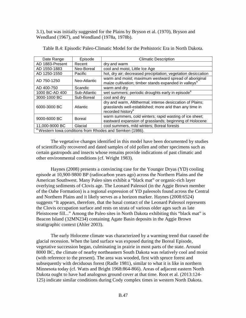
B.47
3.1), but was initially suggested for the Plains by Bryson et al. (1970), Bryson and Wendland (1967), and Wendland (1978a, 1978b).
Table B.4: Episodic Paleo-Climatic Model for the Prehistoric Era in North Dakota.
Date Range Episode Climatic Description AD 1883-Present Recent dry and warm AD 1550-1883 Neo-Boreal cool and moist, Little Ice Age AD 1250-1550 Pacific hot, dry air; decreased precipitation; vegetation desiccation
AD 750-1250 Neo-Atlantic warm and moist; maximum westward spread of aboriginal maize cultivation; timber stands expanded in valleysa
AD 400-750 Scandic warm and dry 1000 BC-AD 400 Sub-Atlantic wet summers; periodic droughts early in episodea 3000-1000 BC Sub-Boreal cool and dry
6000-3000 BC Atlantic dry and warm, Altithermal; intense desiccation of Plains; grasslands well-established; more arid than any time in recorded historya
9000-6000 BC Boreal warm summers, cold winters; rapid wasting of ice sheet; eastward expansion of grasslands; beginning of Holocene
11,000-9000 BC Glacial cool summers, mild winters; Boreal forests a Western Iowa conditions from Rhodes and Semken (1986). The vegetative changes identified in this model have been documented by studies of scientifically recovered and dated samples of old pollen and other specimens such as certain gastropods and insects whose remains provide indications of past climatic and other environmental conditions (cf. Wright 1983). Haynes (2008) presents a convincing case for the Younger Dryas (YD) cooling episode at 10,900-9800 BP (radiocarbon years ago) across the Northern Plains and the American Southwest. Many Paleo sites exhibit a “black mat” or organic-rich layer overlying sediments of Clovis age. The Leonard Paleosol (in the Aggie Brown member of the Oahe Formation) is a regional expression of YD paleosols found across the Central and Northern Plains and it likely serves as a horizon marker. Haynes (2008:6524) suggests “It appears, therefore, that the basal contact of the Leonard Paleosol represents the Clovis occupation surface and rests on strata of various older ages such as late Pleistocene fill...” Among the Paleo sites in North Dakota exhibiting this “black mat” is Beacon Island (32MN234) containing Agate Basin deposits in the Aggie Brown stratigraphic context (Ahler 2003). The early Holocene climate was characterized by a warming trend that caused the glacial recession. When the land surface was exposed during the Boreal Episode, vegetative succession began, culminating in prairie in most parts of the state. Around 8000 BC, the climate of nearby northeastern South Dakota was relatively cool and moist (with reference to the present). The area was wooded, first with spruce forest and subsequently with deciduous forest (Radle 1981), similar to what it is like in northern Minnesota today (cf. Watts and Bright 1968:864-866). Areas of adjacent eastern North Dakota ought to have had analogous ground cover at that time. Root et al. (2013:124-125) indicate similar conditions during Cody complex times in western North Dakota.
B.48
Between 6000 and 3000 BC, there was an estimated 20% decrease in precipitation and a 1-2° C increase in temperature; these changes apparently resulted from a shift to the dominance of mild, dry, Pacific air masses over the Northern Plains (Bartlein et al. 1984). During that time, the last of the stagnant ice melted from the Missouri Coteau and the Drift Prairie (Bluemle 2000:48; Cvancara et al. 1971). Grasslands, better adapted to the warmer, drier climate, and then succeeded the deciduous forest in much of northeastern South Dakota and southeastern North Dakota (Radle 1981). It appears that droughty conditions peaked around 5000 BC when the boundary between the boreal forest and the plains reached furthest northward, about 120 km further north than it has been during historic times (cf. Knox 1983:35). When the prairie environment became dominant, woodlands were restricted to zones bordering lakes, sloughs, streams, and rivers. Under mid-Holocene climatic conditions, vegetative cover is thought to have been denuded over large portions of the state, and the land would have been especially susceptible to erosion. This is the time when the deeply incised former glacial meltwater channels were filled with scores of meters of alluvial sediments eroded from the uplands, tributary valleys, and mainstem valley walls. River channels in valleys tend to downcut during mesic environmental conditions, while valley and channel alluviation typify periods of xeric regimes (Knox 1983:38). Reeves hypothesized that the conditions of the Atlantic episode had no significant effect on the carrying capacity and human occupation of the Northern Plains (1973). He postulated that the population densities of bison and humans were relatively unaffected by the climate of the Atlantic. He suggested that the paucity of Atlantic age sites can be accounted for by the instability of the landforms upon which sites of that age were situated: once they were abundant, but now they have been eroded away. The need to reject or verify Reeves’ proposition, which is still advocated by some students of Northern Plains prehistory, points out the paucity of solid data concerning the climate of the mid-Holocene. It is necessary to know how the climate varied through the centuries and how it differed not only from region to region across the Northern Plains but also across the state. Prehistorians must know specifically how subsistence resource bases were affected by the changing climatic conditions of the Atlantic climatic regime if they are to understand the cultural dynamics of the mid-Holocene. It now appears there were “refugium” areas in the Northern Plains where oasis-like conditions prevailed at times during the Atlantic climatic episode (Kornfeld and Osborn 2003). The Black Hills is one prominent example. There, the Hawken site, which is dated to around 4400 BC, contains the remains of bison with low frequencies of tooth anomalies and low frequencies of postcranial pathologies (Frison et al. 1976). Those traits indicate those bison had good grazing conditions that could not have existed without adequate rainfall in the Black Hills region (cf. Frison 1978:198). Certain areas of North Dakota, such as the Killdeer Mountains, Turtle Mountains, and Missouri River Trench, may also have presented oasis-like conditions. But there may have been times when there were no refuge conditions anywhere. Smaller rivers such as the Little Missouri and the James dried up and ceased flowing during recent periods of minor droughts in the 1950s and 1980s. M. Gregg suggests here that even the Missouri River may have ceased flowing at times.
B.49
The end of the Atlantic climatic episode is posited to have been marked by cooler Sub-Boreal conditions. At that time, the northern leading edge of the plains retreated back southward (or the southern front of the boreal forest re-advanced) to approximately its historically recorded position (cf. Burley et al. 1982:51). The Sub-Boreal apparently witnessed an increase in human population density as represented by the relative abundance of sites of the Oxbow complex. This cultural resurgence signifies improved grassland conditions and a general increase in Northern Plains biomass including in-creased numbers of bison. There needs to be more specific information about the Sub-Boreal climate and the overall environmental conditions of that episode in comparison to conditions that prevailed during other episodes. It must be kept in mind that this model of paleo-climate presents only the most general picture of the state as a whole. Not only did conditions vary somewhat in different parts of the state at different points in time, but also conditions are known to have been variable within each of the episodes. During the Sub-Atlantic in the James River SU, for example, there was definitely a series of fluctuations between times of predominantly mesic, then principally xeric conditions. This is evidenced by a stratified sequence of buried topsoils alternating with undeveloped sediments of Sub-Atlantic age exposed in archeological excavations at the Naze site (32SN246) (Gregg and Swenson 1987:68). Similarly, there were mesic periods during the generally droughty Atlantic episode (also frequently referred to as the Altithermal or simply mid-Holocene) during which conditions were sufficiently favorable for land surfaces to stabilize and topsoils to develop, at least in some parts of western North Dakota (cf. Kuehn 1984). Also, conditions were not persistently droughty during the entire Pacific episode of late prehistoric times. In the “Southwest” culture area, specific droughts are documented at 1276, 1299, and into the 1400s (Schroeder 1988). The conditions of the Neo-Boreal episode are important to understand with reference to earlier episodes because these are the conditions which provided the natural resource base to which the historically documented native peoples of the state were adapted. The generally mesic conditions of the Little Ice Age on the Plains are thought to have resulted in large increases in game populations over the preceding Pacific episode (Reher and Frison 1980:140). However, judging by the thickness and dark coloration of paleosols, the most extended period of favorable climatic conditions in prehistory, subsequent to that of the early portion of the Paleo period, was during the Middle Plains Woodland period. Ahler (1993) and Johnson (2007) provide significant synthesis of sites in the Middle Missouri building on the work of Lehmer (1971) and others. Cultural Chronology Another continuing research endeavor is to expand and refine (1) specific chronological models for particular regions and localities as well as (2) the general statewide model. Upgrades can result from new information concerning past lifeways, identifications of previously unrecognized temporally diagnostic artifacts, and additional dates from newly documented deposits.

B.50
Regarding cultural chronology, Toom and Root (1983b:2.13) wrote:
The initial objective of archeology is to partition or order the archeological record into meaningful and accurate temporal-spatial segments—the construction of a cultural chronology. Temporal-spatial control over archeological data is requisite to answering higher order questions of cultural reconstruction and process. Chronological research involves two interrelated operations. First, it is necessary to date archeological remains and their spatial contexts by objective methods (e.g., radiocarbon dating). Second, this baseline data is used to classify artifacts and their contexts into temporal-spatial-cultural groups, often referred to as periods. Chronological studies use a simplified concept of culture by focusing on the shared aspects of material culture—the shared component of culture—which lend themselves more readily to chronological inquiries than do the ideographic or systematic cultural components. Cultural chronologies are aimed at answering such questions as when and where, they cannot answer higher order questions such as what and why.
Statewide listings of dates as well as other general theoretical or methodological considerations of chronology building can be inserted into this section of the State Plan or can simply be referred to here as necessary. Specific chronologies for particular parts of North Dakota are found in the individual SU sections as applicable. The most refined chronology presently is the one for the Plains Village period in the upper portion of the Knife-Heart region of the Middle Missouri subarea. That chronology is presented in the Southern Missouri River SU. Settlement Behavior Settlement behavior is represented by the many different kinds of sites in the archeological record. The full range of sites in a particular archeological culture may be viewed as a physical representation of its settlement structure. Functional site types are the building blocks of settlement system studies. Functional types differ from descriptive site types such as those coded as feature types on the state site data forms. The term “property type” is used to identify the descriptive site types coded in the site data files. In this way, all sites in the site file database can be considered by property type. But functional site types are another matter. A settlement system is the set of settlements or functional site types used by a human population in the course of carrying out its full range of cultural activities: technological, sociological, and ideological. Settlement systems in most Northern Plains archeological research are conceptualized within the frame of an annual cycle, although a full range of site or settlement types may not be represented within any given annual round. Multiband camps and pan-tribal mortuary ceremonial sites are examples of settlement types that were characteristically occupied less than once a year. Seasonal group movements, whether scheduled or not, probably typified prehistoric peoples of
B.51
North Dakota of all cultural traditions. The movements of the nomadic big game hunters of the Paleo period were probably more extensive and less scheduled with reference to social constraints than were those of Plains Archaic peoples, but both moved in pursuit of mobile prey species as well as to procure special resources that were available seasonally only in certain parts of the state. The various cultural traditions are characterized in part by differences in settlement systems, although some functional settlement types are shared between them. Three generalized kinds of settlement systems are posited for prehistoric North Dakota: one for the hunter-gatherers of the Paleo, Plains Archaic, and Equestrian Nomadic traditions; another for Plains Woodland hunter-gatherer-gardeners; and a third for Plains Village horticultural-hunter-gatherers. But different kinds of settlement systems were not always exclusive between lifeways. There were times and places where Plains Woodland and Plains Village peoples lived hunter-gatherer lifeways, and there may have been times when Archaic peoples gardened to some extent. Native settlement systems may be viewed as comprising varieties of residential bases, field camps, stations, locations, caches (following Binford 1980), mortuary sites, and ceremonial sites. Typically, hunter-gatherer residential sites were occupied at least for the duration of a season by nuclear families, stem families, bands, or multiband groups (cf. Hanson 1983a). Field camps were temporary operating centers for task groups such as hunting parties or residential groups on the move. There seems to have been no particular limitation on the size of a task group which might have occupied a field camp. In some cases, several bands totaling hundreds of people congregated for communal bison hunts. A station was a place such as a hunting lookout used by a task group for information gathering. A location was a place where raw materials were procured and/or processed, e.g., a chert collecting/workshop site or an eagle trapping pit. A cache was a place used for the field storage of subsistence or technological goods, for example, a stash of dried meat or chipped stone tool preforms. The remains of the deceased were interred at mortuary sites. Unknowable varieties of ceremonial sites used by individuals and groups make up another functional site type; examples include vision quest sites and medicine wheels. It is suggested that these and more refined classes of functional settlement types will be of heuristic value in better understanding the lifeways of Paleo, Plains Archaic, and Equestrian Nomadic hunter-gatherers. Plains Woodland hunter-gatherer-gardeners should have generated a similar range of site types. But there were also unique elaborations and modifications. Some residential base settlements included semi-permanent domestic structures (although this may have been the case at times in the Archaic as well). Locations included gardens and places where ceramic clay was collected. And there were mortuary sites where earthen mounds were built. The settlement systems of Plains Village horticultural-hunter-gatherers were elaborated over those of Plains Woodland groups (Swenson 2007). The Villagers had larger and more intensively worked garden locations and larger residential base settlements comprising bigger and more permanent domestic structures (sometimes
B.52
earthlodges). The residential bases of some Plains Village archeological cultures were fortified. The Villagers sometimes traveled out into distant parts of the Northwestern Plains, especially for bison hunting (cf. Bowers 1948, 1965:50-57, 167-160; Reher and Frison 1980:138). Sites there would be classifiable functionally as if they were the settlements of hunter-gatherers because they were left by Villagers in hunting and gathering modes. It can be inferred that the placement of most Plains Village earthlodge villages on the west bank of the Missouri at the mouth or downstream from the mouth of permanent tributary streams flowing in from the western plains was for the purpose of reducing the efforts required to move subsistence resources from the tributary valleys to the residential bases. Laying out operational definitions for such sets of functional settlement types is more difficult than merely making lists. For example, where is the line drawn between residential bases and field camps? How is a processing location distinguished from a processing area within a residential site? If an Early Archaic site has a pithouse feature (e.g., Miller 1988), does it necessarily qualify as a residential base? Questions that are more precise will lead to research that is more specific and a better understanding of settlement systems. What do measures of artifact diversity mean vis-à-vis occupational intensity or site function? Taken alone, measures of artifact diversity should not be used to identify site types (Thomas 1988:91). Some procurement locations contain more diverse artifact assemblages than others, and some locations have more varied assemblages than some field camps (ibid.). Also, Dunnell (1988:36) has cautioned against characterizing sites based on the results of merely one episode of surface reconnaissance. Deposits resulting from single versus multiple episodes of occupation cannot ordinarily be distinguished based on the results of just one surface collection. Further, isolated artifacts should not be written off as “insignificant anomalies” after a single episode of surface survey. Another visit to such a find location under different surface conditions can reveal site deposits in the area of what was initially thought to be an isolate (ibid.:37). Interpretations and inferences regarding settlement behavior must take site formation processes into account. This goes for analysis of excavation data as well as surface collection data. For example, the analysis of an extensive stone circle site typically reveals that it does not represent a single large encampment, but rather a number of smaller encampments on the same landform (e.g., Deaver and Deaver 1988). Also, at sites other than stone circle sites, the areas of densest artifact deposits often do not represent the actual centers of the occupation areas or even specific activity loci, but rather “palimpsest” areas of overlapping debris scatters resultant from multiple occupations (Ebert 1988:6). Stone Circle Sites Stone circle features are of special research importance in North Dakota because many of them remain largely intact in areas of unplowed native grassland. The vast majority of the features are the remains of dwellings that were used for relatively short
B.53
periods of time. Unlike prehistoric “house” sites in the Eastern Woodlands or Southwest, the durations of use of most tipi setups were days or months and not years. Because of the short duration of occupations and the minimal material cultural repertoire transported by people on the move who dwelled in them, most stone circle sites produce only small quantities of simple artifacts. (There are exceptions such as the solitary stone circle at the Bear Den site [32DU175] which yielded thousands of artifacts upon excavation [Kuehn and Perry 1986]). Nevertheless, stone circles are often prominent markers for a very special kind of site: a site containing artifacts and features from a single episode of occupation. Paradoxically, stone circles sites with the fewest artifacts are most likely to be single-occupation settlements with the greatest potential to yield new information concerning tipi encampment activities. Stone circle sites came to the center of attention in cultural research management in the 1970s when coal strip mining companies in North Dakota and throughout the Plains encountered more of this kind of site than any other when future mine areas were inventoried for cultural resources as part of the Section 106 compliance process. The companies wanted to see uniform guidelines implemented for evaluating the NRHP eligibility of stone circle sites and for conducting impact-mitigating salvage excavations when stone circle sites were to be destroyed in the process of mining. The first two management documents pertaining to this specialized topic in North Dakota were products of the North Dakota State Historic Preservation Office (ND SHPO). The ND SHPO awarded a Historic Preservation Fund grant for a comprehensive overview study of stone circle sites which resulted in a report entitled Stone Circles: A Review Appraisal and Future Directions by Quigg and Brumley (1983). Also, the ND SHPO’s office issued Guidelines for the Recording, Evaluation and Mitigation of Adverse Effects to Stone Circle Sites in North Dakota (Dill 1983). The Dill (1983) guidelines have since been determined ineffective in site evaluation. Mitigation now involves formal excavation units (1-x-1-m) by project/site or based on a management plan. Perhaps because stone circle sites have been a persistent concern in strip mine expansion and because these sites often need to be evaluated and treated expeditiously, several stone feature specialists have emerged in North Dakota archeology. In the 1970s, it was Kent Good, first affiliated with the University of North Dakota and later with private consulting firms. In the 1980s, it was Ken and Sherri Deaver with their consulting firm, Ethnoscience, Inc., Billings, Montana. Ethnoscience, Inc. continues the work under the direction of Lynelle Peterson. A look at the lists of reports of test excavations and major excavations in the Southern Missouri River and Knife River SU will lend an impression of the number of investigations involved. A major work by the Deavers, Dancing Grouse: A Tipi Ring Site in Central North Dakota, in conjunction with the background and guideline volumes by Quigg and Brumley (1983) and Dill (1983), provides a comprehensive overview of stone circle site considerations for North Dakota.
B.54
A landscape perspective for stone circle sites recently has been applied to tracts in the mining region (Artz and Goings 2006; Dooley 2004). Settlement behavior trends are being targeted for this site type. Statewide Population Density One variable that was certainly a consideration in settlement behavior was the overall population density of the group (band, ethnic group, or tribe) and its neighboring groups in the region. The density of people in North Dakota undoubtedly varied a great deal through time. There were probably very few people anywhere in the state during times of severe drought such as the Altithermal. On the other hand, before the epidemics of European diseases first hit the Northern Plains, perhaps in the 1600s, population density was probably high, maybe the highest it had ever been. Socio-cultural adaptations were finely attuned to the Northern Plains environment, and the resource base was rich. The environmental conditions of the Little Ice Age favored increased bison herd sizes as part of an overall increase in the biomass of the entire Plains. Population density in North Dakota today is approximately 9.3 people per square mile. Densities for hunter-gatherers around the world range from 0.01-2.0 people per square mile (Hassan 1975:38). Groups at the high end of that range occupy areas with very rich and reliable subsistence resource bases. Steward (1968:103) estimated densities for the Great Basin Shoshoni varied from 0.01-0.2 people per mile. In North Dakota when times were good, as they were for the Villagers late in prehistory before they were decimated by the plagues, their numbers may have totaled 10,000 or so in a territory of about 50,000 square miles. That translates to a density of 0.2 people per square mile. Population densities must have been lower for non-Village peoples. When subsistence resources were abundant, there may have been an overall density of 0.1 people per square mile. With the state’s total area of roughly 70,700 square miles, the total population probably never exceeded 15,000 people. When times were dismally poor and population density was approximately 0.01 people per square mile, there may have been as few as 800 people in North Dakota (Gregg and Hanson 1985:53). Native Subsistence Practices Subsistence practices are the procedures implemented by human groups to acquire food and technological resources needed to maintain nutritional requirements and protect the group against extreme climatic conditions through food storage, clothing, housing, and heating. Methods of selecting, acquiring, and processing of resources varied temporally and culturally. Floral and faunal remains are the most commonly recovered materials relevant to considerations of subsistence practices. Any intact archeological deposit with good samples of floral or faunal remains has potential to yield important information, minimally at the level of a particular historic context. The general chronological model posits the presence of five cultural traditions during the state’s prehistory. The traditions are differentiated primarily by subsistence
B.55
practices. The Paleo lifeway of hunting and gathering animal and plant resources of the early Holocene has been documented from a few archeological sites within the state. Plains Archaic subsistence was based on hunting and gathering adaptations to essentially modern animal and plant resources. Dogs may have been the most dependable, “storable” food resource prior to the advent of full-blown horticulture. The subsistence practices of Plains Woodland tradition groups included gardening as well as hunting and gathering wild resources for food and clothing. The concept of a Plains Woodland tradition has been incorporated in the chronology because of temporal and stylistic similarities between Plains Woodland materials from the eastern part of the state and those from elsewhere in the Northeastern Plains. This period saw the genesis of mound burial ceremonialism and the production and use of ceramic vessels, two practices that imply more permanent residential settlements than during earlier periods. The gathering of indigenous seedy plants and grasses for food could have intensified and developed into part-time gardening, stimulated perhaps by increased regional interaction. Faunal assemblages from Plains Woodland components throughout the state are dominated by bison bone. Bison were a critical resource during all of Northern Plains prehistory (cf. Michlovic 1986b). The Plains Village period in the Middle Missouri subarea was characterized by subsistence based as much on gardening as on hunting and gathering (Lehmer 1971:27). A Plains Village lifeway is hypothesized to have prevailed during that time period throughout most of the state. The subsistence practices of peoples living Equestrian Nomadic lifeways where dependent primarily on the use of horses for hunting bison. The mobility afforded by horses enabled much larger territories to be exploited for seasonally available resources. That mobility also enabled the Equestrian Nomads to build long-distance trade relations into their seasonal rounds. Variations in prehistoric hunting, gathering, gardening, and food processing practices become more apparent as archeological research progresses. Site formation processes and archeological recovery techniques must be given careful consideration in demonstrating that the variations are not merely apparent but real. Cultural preferences, site seasonality, changing environmental conditions, and evolving technological capabilities are some of the factors involved in accounting for the real variations. Technologies Technology is a human capability to modify elements of the physical environment to create effects that will promote the perpetuation of a social system. Modifications of natural resources by Native American groups resulted in distinctive lithic, ceramic, and bone technologies. Sometimes these modifications were so extensive and/or patterned that they became stylized. The methods of manufacture and use of stone tools, ceramic

B.56
vessels, and bone tools are technological traits that can be examined through artifact analyses. Many sites investigated throughout the state have yielded information and data relevant to the study of stone tool technology. The time range represented by these sites includes the period of transition from the exclusive use of the atlatl to the use of the bow and arrow. With the shift in projectile weapons technology, projectile point production technologies and styles changed. Lithic reduction operations shifted from the production of large thin patterned bifaces by percussion flaking to the production of small thin patterned bifaces by pressure flaking (cf. Ahler and VanNest 1985). “Mass analysis” has been developed as a method for determining flintknapping procedures represented by large samples of flaking debris (Ahler 1989). Studies of chipped stone artifacts can enable inferences concerning lifeways. For example, the occurrence of increasingly smaller arrow points through the late prehistoric to protohistoric stratigraphic sequence at the Vore site (48CK302) was interpreted by Reher and Frison (1980:140) as possibly reflecting a shift to a smaller bow and arrow for use from horseback (Reher and Frison 1980:140). Distinctive, small corner-notched projectile points were recovered from an Early Plains Woodland deposit in the James River SU and in Late Plains Archaic contexts in SU in both the eastern and western parts of the state (Gregg 1987c:262-264; Gregg et al. 1986:130-164; Toom 1983b). While there are suggestions that people in various parts of North America may have begun experimentation with the bow and arrow several hundred years earlier than previously thought (cf. Odell 1985; Webster 1980), the small points from these contexts are probably atlatl dart tips. Small dart tips appear to have been used from the Early Plains Archaic period until at least the Middle Plains Woodland period in the Northern Plains. Small points have been interpreted as evidence for the use of lightweight fast projectiles (Christenson 1986). Further research on this topic may lead to new understanding of hunting practices and warfare. There were variations in the frequency of use of different kinds of stone during several of the time periods in different parts of the state. These cases might reflect technological selection or might represent technological responses to other cultural and/or non-cultural environmental changes. Some technological traits which characterize particular archeological complexes or time periods have utility for relative dating. The intentional thermal alteration (or heat treatment) of KRF has been carefully studied by Ahler (1983). Heat-treated KRF has certain distinct traits which are readily identifiable. So does Swan River chert (Gregg et al. 1987; Gryba 1988). It may prove to be that KRF was regularly heat-treated only during late prehistoric times while Swan River chert was regularly heat-treated beginning in Paleo times. Two lithic technological procedures represented during the Paleo period are Folsom fluting and blade production (cf. Ahler 2003; Schneider 1982d:35-36, 1982c). Ahler and Geib (2000) provide a well-developed explanation for Folsom point design and adaptation. They recommend a model be “tested and refined through studies of finished
B.57
point and preform length, artefact proportions and fracture patterns, basal margin treatment, use-wear in archeological specimens and through actualistic studies of experimental point/haft arrangements” (Ahler and Geib 2000:817). Ceramic technologies represented in artifact assemblages from many components also reflect temporal and cultural variability. The relatively high density of potsherds at some sites indicates ceramic vessels were produced locally using resources that were collected nearby. Ceramic technologies improved through time as evidenced by the production of thinner, better made, and probably larger vessels during the Late Plains Woodland period than during the Middle Plains Woodland period. Some of the technological traits of ceramics which varied include paste, temper, and production techniques. A rigorous program for recording manufacturing techniques in conjunction with decorative procedures will enhance understanding of changes in ceramic technologies (Ahler and Swenson 1985a; Krause 2007:32-40). Cord roughened surface treatments are characteristic of Late Plains Woodland pots in the Missouri Trench (Ahler et al. 1981, 1982; Wood and Johnson 1973) and are common at Late Plains Woodland sites along the upper James River (Schneider 1982a; Snortland-Coles 1985). In the lower James River valley of South Dakota on the other hand, cord roughening actually is characteristic of early Plains Village pottery (Alex 1981). Also, ceramics from Plains Village sites in the Sheyenne River valley “tend to exhibit a higher frequency of cord marking on the body than is normally found in the Plains Village components in the Missouri Trench” (Haury and Schneider 1986:255). In the eastern part of the state, cord roughening typifies late prehistoric Sandy Lake ware collections (cf. Anfinson 1979). The science behind such inferences and generalizations is important. Will the findings be replicated by analyses of additionally recovered, representative samples? Modified antler and bone artifacts have been identified in the faunal assemblages from many excavated and surface collected sites throughout the state. Bone technologies are represented not only by the actual finished bone tools, ornaments, and other objects, but also by bone working debris and the stone tools used to work the bone. Objects were made from bone by the first people to inhabit the Plains in the Paleo period. Antler and bone technologies are well-documented aspects of Plains Village cultures (cf. Falk et al. 1980; Lehmer 1971; Smith 1972:72). It should become possible with further study to identify functional and/or stylistic traits of some bone tools as culturally or temporally diagnostic indicators. The oft mentioned “elaborate bone technologies” of the Plains Village cultures may be more a result of preservation than any actual increase in the use of bone. Bone artifacts from Plains Village sites are better preserved than bone from other kinds of sites because the Village sites are more recent than other sites, and earthlodge villages usually were built on terrace landforms with very well drained soils resulting in excellent preservation of organic materials from those villages.

B.58
Artifact Styles Artifact styles are deliberately perpetuated, repetitive, patterned attributes of material culture. Studies of style in archeology have necessarily focused on durable remains such as stone tools, ceramic vessels, and rock art. Some prehistoric artifact styles as well as some historic styles endured to the extent that they are now recognized as diagnostic of particular time periods, cultural complexes, or other named archeological units or eras. The cultural or temporal affiliations of surface artifact collections and excavated components are most often initially identified by comparing the recovered stylized artifacts with similar materials described from dated cultural contexts elsewhere. Styles of patterned tools and ceramics are sometimes distinct within a social group or association such as a tribe or a club. At other times, they have geographically and socially extensive distributions that transcend the territorial boundaries of groups and the cultural boundaries of associations. It is usually difficult to determine which condition prevailed when a particular aggregate of archeological materials was deposited. Most often, however, an increase in projectile point stylistic variability through time within a particular locality or site is viewed as an expression of increased ethnic variation (cf. Reher and Frison 1980:142). Similarly, Pettipas (1982:62) noted that point samples from most Paleo sites are characterized by a single type, but that a few sites contain multiple types. He suggested that styles within a site tended to be consistent because point knapping was a men’s activity during Paleo times and that styles were traditionally maintained by patrilocal bands or band aggregates (ibid.). He proposed that a limited amount of male mobility between bands accounts for those few components with multiple types. Alternatively, the occurrence of different styles of points could in some cases reflect cooperative hunting endeavors between bands or band aggregates that made different styles of points. Little major advancement can be expected in the study of ceramic vessel styles until researchers collect stylistic data uniformly. To this end, North Dakota archeologists are encouraged to attempt to use the data codes for lip forms, rim forms, decorative techniques, decorative patterns, ware classifications, and type classifications offered by Ahler and Swenson (1985) when dealing with Plains Village ceramic collections from sites in the state. It is also important to become more specific in identifying “cordmarked” or “cord roughened” exterior surface treatments. Plasticine or latex materials should be used to take impressions of cordmarked surfaces in an attempt to identify diagnostic exterior surface treatments (cf. Syms 1980). Within samples of sherds described as “cordmarked,” it is often possible to distinguish between impressions made by netting, sprang fabrics, and cord-wrapped paddles. Regional Interaction Investigations of regional interaction aid local studies by broadening the array of known artifacts and cultural practices to which groups in a particular SU might have been exposed. Cultural characteristics of neighboring and distant groups could have been transmitted into a given SU through group interaction. Minimum extents of interaction
B.59
can be appraised by identifying geographic distributions of dated artifact styles. Like people of today, peoples of the past adopted numerous important innovations that were developed in places other than where they lived. These included technological innovations such as making pottery vessels, food production innovations such as gardening, and ceremonial innovations such as burying the deceased in earthen mounds. Reher and Frison (1980:137) posited that prehistoric cultural adaptations to the short grass environment were more secure for people who maintained flexible, far-flung social networks. Interactions that were more extensive resulted in greater resource availability. Archeological investigations over the 1970s and 1980s provided good evidence for regional interaction-trade-exchange between inhabitants of the Northern Plains and Eastern Woodlands during most of the Holocene (Brose 1979; Frison 1978; Gregg 1985c). Interaction can be studied by exploring similarities in artifact styles, particularly in the realms of lithic and ceramic items, as well as by identifying actual samples of exchanged raw materials and artifacts. Patterned stone tools, particularly projectile points, sometimes displayed surprising similarity in morphology for extended periods of prehistory over broad geographic areas. When they were in vogue, Plains Archaic styles such as Simonsen, Oxbow, McKean, Hanna, and Pelican Lake appear to have been adhered to throughout the Northern and Central Plains for many centuries. Besant side-notched points from Middle Plains Woodland deposits represent a style that has been identified as dominant at many sites in the Northern Plains. This style appears to have been closely followed at Sonota complex sites in South Dakota (cf. Neuman 1975) as well as Besant sites in Montana and Alberta (Reeves 1983). The style endured for at least 500 years. Such sty-listic distributions indicate minimum geographic extents of interaction. Similarly, native ceramics can reflect regional interaction through features of vessel decoration. Early Plains Woodland ceramics from the James River SU share strongest ties with materials recovered from sites in the Prairie Peninsula portions of southwestern Minnesota and northwestern Iowa (cf. Anfinson 1979; Benn 1983). In fact, Early Plains Woodland ceramics from throughout the Northeastern Plains and Midwest share vessel form, surface treatment, and decorative traits with those found in the Prairie Peninsula (Farnsworth and Emerson 1986). Most Middle Plains Woodland ceramics in the state appear to be attributable to Besant/Sonota components which are distributed across large portions of the Middle Missouri, Northeastern Plains, and Northwestern Plains subareas. Although hampered by small samples, Late Plains Woodland pottery appears to exhibit greatest similarities to Brainerd, Blackduck and Sandy Lake wares that are most common at sites in eastern parts of the Northeastern Plains and adjacent portions of the Eastern Woodlands. Toom (2003; Jackson and Toom 2004) has identified and reported on Brainerd ware ceramics in assemblages from upper James River and Devils Lake sites that have
B.60
been chronometrically dated to AD 600-900. Brainerd ceramics were originally defined in west-central Minnesota (Anfinson 1979) as a late Middle Plains Woodland ware, comprising net-impressed and horizontally corded types or varieties. Toom includes Brainerd ware in an early Late Plains Woodland time frame but as part of a Middle Minnesota Woodland period derived from its suspected point of origin and influence. Lifeways practiced by early Late Plains Woodland peoples in eastern North Dakota remain to be fully explored and described. Likewise, attendant cultural complexes proposed by archeologists warrant refinement as more information becomes available with respect to technology, subsistence practices, settlement practices, and cultural developments over time and across space. Other important indicators of regional interaction are nonlocal stones that were brought into an area. Investigations in the KRF primary source area have disclosed that intensive quarrying took place during Late Plains Archaic times (Ahler and Christensen 1983:255-261; Metcalf et al. 2009; Root et al. 1985:134). Two possible explanations for intensified KRF extraction are that material was being used more heavily by local peoples at that time, or increased quantities were being quarried for regional exchange. Plains Woodland populations also heavily utilized KRF for making patterned chipped stone tools. Sites of the Middle Plains Woodland Sonota and Laurel complexes often contain especially high percentages of KRF tools and flaking debris (Neuman 1975; Stoltman 1973). Finds of finished KRF mortuary goods in Middle Plains Woodland burial mound sites in Wisconsin, Illinois, and Ohio provide evidence for the exchange of KRF (like obsidian) over great distances during the Middle Plains Woodland period (Anderson et al. 1986; Clark 1984; Conrad 2004; Farnsworth and Asch 1986). The plains-woodland ecotone (or the parklands), presently not far to the northeast of northeastern North Dakota, is an important consideration in regional interaction. Ray (1972) argued that the parklands were not merely an environmental transition zone between two distinct habitats. Rather, the parklands have always represented a zone of ecological diversity and resource abundance. The parklands are an ecotone with overlapping animal and plant distributions from the plains to the south and the boreal forest to the north. Peoples of the southern boreal forest, the western portions of the Eastern Woodlands, and the Northern Plains are believed to have interacted throughout prehistory, minimally in the course of their subsistence pursuits. Field, Laboratory, and Analytical Methodologies The actual methodological workings of archeology became an important focus of research as a result of three heavy-impact developments in the field: (1) the inception of the “new archeology” (cf. Binford 1972a, 1972b; Flannery 1967); (2) the expansion of interdisciplinary scientific approaches to the analysis of archeological remains; and (3) a new awareness of site formation processes (Schiffer 1972, 1976, 1983). In fact, this research into how archeological research actually works—from the size of artifacts being recovered to the relevance of certain sorts of data to particular kinds of behavioral inferences—is sure to remain a prominent field of inquiry for some time to come.
B.61
Following are examples of the kinds of questions being asked. What sorts of information will be lost if site matrix is screened through one-quarter inch mesh screen rather than one-sixteenth inch mesh? What is gained by applying flotation (cf. Struever 1968) recovery procedures to feature fill? What sorts of refined behavioral inferences are possible when data are collected regarding differences in size grades for various classes of artifacts and ecofacts? Can the applications of high-powered statistical procedures to flaking debris size grade data and other “mass analysis” data (cf. Ahler 1989) actually result in more accurate determinations of the flintknapping procedures represented at a site than seemingly simpler morphological studies of cores and flaking debris? Archeological methodology has always been part of archeology, and now it is explicitly so. Treatment of the Individual Study Units Each of the 13 SU in the state is dealt with in a uniform manner in the following sections of the State Plan. The same set of topic headings is listed consistently, and the format is the same. Only the content differs. Description of Each Study Unit Introductory information for each SU considers topography, hydrology, climate, soils, lithic raw materials, and floral and faunal resources. An attempt is made to emphasize the natural resources thought to have had particular effects on native land use practices within each drainage basin. There is a list of all legal locations by township and range included in each SU. Overview of Previous Archeological Work Past work in each SU is summarized by type of work: inventory, test excavation, major excavation, and other. Inventory Projects Major Class II and Class III surveys are mentioned. This section contains considerations of when, where, and why those surveys were conducted and the survey procedures that were employed. Geographic Information Systems (GIS) has been used to digitize Class III inventories and site locations at the Archaeology and Historic Preservation Division (AHP) of the State Historical Society of North Dakota (SHSND). The GIS databases will enable future spatial analyses. As of 2008, all Class III inventories with adequate maps and all site locational information have been digitized. Manuscript data record forms should be completed with submitted project reports. Manuscript records and coded site forms are entered into Microsoft Access databases and GIS. North Dakota SHPO guidelines for survey and site recordation are available online at

B.62
http://history.nd.gov/hp/hpforms.html (SHSND 2016). Table B.5 indicates the total acreage and percent inventoried at the Class III level for each SU, as of August 5, 2015.
Table B.5: Total Acreage and the Percent Surveyed of Each Study Unit.
Study Unit Total Acreage Percent Surveyed (September 2007)
Percent Surveyed (August 2015)
Little Missouri River 3,079,680 11.0 17.2 Cannonball River 2,718,720 3.0 5.7 Knife River 1,566,720 12.5 19.1 Heart River 2,142,720 4.5 8.3 Southern Missouri River 6,197,760 3.2 6.8 Garrison 5,116,800 6.1 13.0 James River 4,216,320 2.4 9.8 Grand River 552,960 9.7 13.9 Northern Red River 4,861,440 1.6 2.8 Southern Red River 1,535,360 3.9 7.0 Souris River 5,857,920 2.0 3.3 Sheyenne River 7,050,240 2.3 4.0 Yellowstone River 437,760 15.0 28.9
Site Data Tabulations Tables displaying landforms by property type were created by running a query in the NDCRS database. The cross tabulation of landform by property type for recorded sites in each SU are limited by the completeness and accuracy of data in the computerized site data files. The following is an itemization of problems that were noted in the site data listings. As pointed out by Dancy (1988:15), “site record data reveal more about the identification and recording processes than actual site densities and distributions.” Implications for limitations in the cross tabulation are noted. “Landform 2” data, the information used in the tables, was missing for some records. Sites for which this data was missing were not included in the landform by property tabulations. Most “missing data” resulted from coding old site forms after the inception of the computerized site file database in 1980. Many of the older site records simply did not locate sites precisely enough to enable plotting on USGS maps to determine site locational information. The older site records were lacking in other sorts of data as well. In a similar set of cases, there were erroneous entries (e.g., “71”) in the “Landform 2” data field. Some of this eventually can be corrected utilizing GIS. In cases where “Feature Type” was coded “2” (probable), the feature type was not tabulated. In some of these cases, no feature type was coded “1” (present). In a parallel set of cases, no feature type was coded either “1” or “2.” In both kinds of cases, no feature type (site type) was known with certainty to be present. Such site records were not included in the property type by landform tabulation.
B.63
A query was run in the site file database to determine which sites have been coded for “Cultural/Temporal Affiliation.” Cultural/temporal affiliation often has not been coded. These cases were identified as “Unknown” and listed at the bottom of the tables. As sites are updated, some of this can be corrected. A few of the best documented and most fully recorded sites in the database were not included as in the tabulations because there were multiple entries for both “Feature Type” and “Cultural/Temporal Affiliation.” Looking at the data listings for these sites, it was not possible to tell which feature types correlated with which affiliations. For example, Pelican Lake, Besant, and Plains Village might be coded along with CM Scatter, Other Rock Feature, and Stone Circle. It would be necessary to go to the investigative report for each site to determine, for instance, that the site has Pelican Lake stone circles, Besant cairns, and a Plains Village cultural material scatter. Many of the problems with the site files result from failures of field archeologists to update site forms with results from testing, major excavation, or other study subsequent to the initial recording. Until all archeologists update forms, the site files will be compilations of survey data and their full value will not be realized. Everyone should do his or her part in correcting an updating the database. Also in the section covering inventory results for each SU, gaps in survey coverage are identified. Variations between different parts of each SU as well as between SU are considered with reference to property types and overall site densities. Published reports, typically containing substantive information, are cited in the text, and complete bibliographic information is presented for them in Cited and Selected References chapter. Test Excavation Projects Discourse here covers all test excavation projects with substantive results in each SU. It is also useful to consider some tests with negative results where artifact deposits were anticipated but not found. Information from negative tests can be helpful for developing general site evaluation policies and specific plans for future testing. Testing strategies and sampling designs employed in each SU are reviewed. The adequacy of past approaches to testing is assessed. Inadequate testing leads to poor mitigation, and that discounts the limited financial and professional resources available to archeology (cf. Corkran 1988). Tested landforms and total numbers of tested sites are identified. As with the preceding inventory section, a list is presented of manuscripts and published reports dealing with archeological test excavations in the drainage. As time goes on, reports from years gone by that failed to make the initial listings will be incorporated, and new reports will be added to keep the list current.
B.64
The reader is directed to the National Park Service (2016) website (https://www.nps.gov/nr/) for information regarding archeological sites in North Dakota listed on the NRHP. Major Excavation Projects The goal here is to identify manuscripts, technical reports, and published accounts of all major excavations at sites in each SU. The difference between tests and major excavations is not always clear, but most of the major excavations represent salvage, rescue, or mitigation archeology. Other Work Results of other sorts of archeological work are presented in this final category. It is intended to be a list of known manuscripts and published reports that deal with works other than survey, testing, or full-scale excavations. The kinds of reports treated in this category include (1) file search overviews; (2) intersite comparative studies beyond primary inventory or excavation reporting (e.g., variable use of the Badlands through time); and (3) topical research concerning specific materials such as flints and clays. There are many publications pertinent to North Dakota archeology that do not relate specifically to any one particular SU. Examples include studies of hunter-gatherer settlement systems, eagle trapping, postulated prehistoric exchange behavior, heat treatment of chert, paleo-climatic conditions, artifact style, bone technology, and Plains Village social organization. Many of these sources are covered in the introductory section covering research topics in North Dakota archeology as well as subsequent portions of the individual SU sections where data gaps, research questions, and historic preservation priorities are discussed by time period. Coverage by Cultural Periods It is at this level that historic contexts are explicated in the archeological component of the State Plan through the conjunction of spatial units, temporal units, and research topics. For all of the SU, archeological contexts are enumerated by time periods and research topics. The temporal categories are the Paleo, Plains Archaic, Plains Woodland, Plains Village, and Equestrian periods. Note that the Early, Middle, and Late Plains Archaic periods are considered together beneath one heading, as are the Early, Middle, and Late Plains Woodland periods. Individual research questions and problems are underlined in each historic context statement for all SU throughout the document. Paleo-Environmental Modeling Unique environmental conditions that are known for each time period and SU are identified. For this research topic and all others, there is room for discussion of (1) data from inventory, test excavation, and major excavation projects, (2) data gaps, and (3) research questions of specific interest. Of course, treatment of data gaps and research
B.65
questions by research topic for every SU and time period is an endless effort. The extents of these sections are limited by the amount of time spent on them. As the State Plan evolves over the years, databases will increase, some data gaps will be filled, others data gaps will be identified, old research questions will be dropped, revised, and resolved, and new ones will be formulated. For example, the role of refugia during Paleo and Plains Archaic times remains a viable research topic (Hoffecker et al. 2014). Cultural Chronology Here, matters related to cultural chronology specific to each SU and time period are covered. Times and artifact complexes are identified which ought to be represented but are not. Based on the data and data gaps, specific research questions are enumerated. For example, should sites of the Goshen complex be anticipated in the western portions of the Little Missouri River SU due to proximity to the Mill Iron site in Montana? In the Northern Red River SU, is there any reason to expect Coalescent residential sites? Settlement Behavior For each SU and cultural period, there is an effort to consider property types from the perspective of the kinds of settlement behavior that have been postulated or demonstrated for the period. Due to scant databases, however, most of these contexts are sketchy. Much of the landscape throughout the state that was use by Paleo peoples for settlement more than 7,500 years ago has been removed by erosion. Furthermore, undoubtedly some types of sites which once existed have been totally removed from the archeological record. This phenomenon of obliterated site contexts is most dramatically represented in the Little Missouri Badlands (cf. Running and Wyckoff 1988). Native Subsistence Practices Broad perspectives concerning subsistence practices are presented in the background information in the introductory portion of the Archeological Component of the State Plan. Considerations of subsistence endeavors by period and SU are grounded in excavation data, survey findings, and speculations involving paleo-environmental reconstructions and ethnographic analogy. Most of the discussions at the context level involve paleo-environmental data from the particular drainage basin under study. As with each research topic, available data are presented, some data gaps are specified, and some specific research questions set forth. Technologies Stone, bone, ceramic, and other technologies are considered by period and SU. As with subsistence practices, broad perspectives concerning prehistoric technologies in general are covered in the introductory background materials preceding the individual SU sections. Contextual considerations involving this research topic, as with most others, may range from general (e.g., the bone technology of the Plains Villagers) to specific (the fluting of Folsom points made from heat-treated Swan River chert).
B.66
Artifact Styles The identification and description of distinctive artifact styles is the basis of cultural cross dating (also referred to as typological dating). Cross dating is the dating technique used most frequently for estimating the ages of archeological components throughout the state. However, the popular styles of the various cultural periods typically transcend the boundaries of SU and often extend statewide. Individual styles such as projectile point types and pottery wares are treated comprehensively only in one SU, preferably the one in which they most commonly occur. As with each research topic, available data, data gaps, and research questions are covered for each SU and period. Regional Interaction Specific occurrences of regional interaction can be posited when (1) artifact styles or raw materials from outside a SU are found within and (2) styles or raw materials from within are found at sites in other drainage basins or outside the state. Examples of imports include Rocky Mountain cherts during the Paleo period, Lake Superior copper during Late Archaic, obsidian during Middle Plains Woodland, and Dentalium sp. shell during the Plains Village period. Known cases are reported by SU and time period along with discussion of data gaps and research questions. Historic Preservation Goals, Priorities, and Strategies The explications of contexts by these research topics for each cultural period and SU conclude with identifications of shortcomings in the databases and enumerations of research questions that might be addressed by future work. This subsection at the end of each section of coverage for a particular SU and cultural period highlights data gaps and research questions, and then suggests priorities and strategies for dealing with them. Strategies involve matters ranging from field procedures to data collection procedures to funding sources. This is the section addressing strategies for protecting particular kinds of sites.
Discussion of National Register Eligibility Criteria
Archeological properties—predominantly sites and districts--may be determined eligible for listing in the NRHP if they possess integrity and:
A. are associated with events that made significant contributions to the broad patterns of prehistory; or B. are associated with famous or important people; or C. embody the distinctive characteristics of a type, period, or method of construction, or possess high artistic values; or D. have yielded, or might yield, important information at the local, state, or national
level of significance.
B.67
Most archeological properties are determined eligible under criterion D. However, it is possible that an archeological site could lack the potential to yield important information but still be eligible under criteria A, B, or C. For instance, the oral history of the Low Hat clan documented the Blue Buttes as the place of origin for their clan. Even though the archeological evidence is scant and may lack the potential to yield important information, oral history would support NRHP eligibility of Blue Buttes under criteria A (the founding of the clan and subsequent ceremonial events) or B (association with the clan founder). Archeological properties are generally determined eligible based on their potential to yield important information at the state or SU level of significance. The potential importance of site information is assessed with reference to a particular research topic, period of time, and area of concern: a historic context. Sometimes the level of significance will transcend SU boundaries and extend through an archeological subarea (e.g., the Northwestern Plains) or area (the Northern Plains as a whole). For example, the origins of Plains Woodland lifeways in one North Dakota SU are important to considerations of Plains Woodland cultural developments throughout the Northern Plains. What size of geographic area is minimally required to qualify for a local level of significance in prehistoric and protohistoric archeology? It definitely can reach the level of an archeological region and sometimes to an area as small as a part of a region or a locality. For example, the importance of information held in archeological deposits within the Knife River Indian Villages National Historic Site is often appraised with reference to some aspect of the prehistory or proto-history of the upper portion of the Knife-Heart region of the Middle Missouri subarea. Another prominent consideration in determining eligibility regards the integrity of the archeological deposits. Integrity is usually evaluated by appraising the extents to which the artifacts and features in the deposit have been moved, mixed, or otherwise damaged by natural or cultural processes so as to diminish their information potential. The degree of integrity or “intactness” required for an archeological deposit to yield important information depends on the statement of significance and historic context for the property. If the site under consideration is a multi-component Late Plains Woodland residential site in the Northern Red River SU with occupations dating from AD 400-700, it would be necessary to have well-stratified intact cultural levels for the site to be likely to yield important information regarding changes in material culture during that 300-year period. However, the site would be likely to yield important information regarding paleo-environmental conditions in that SU during that time. Another example would be a plow zone lithic scatter in the Grand River SU. If the age(s) of occupation could not be identified, such a site would typically be evaluated as not eligible. However, if diagnostic artifacts and patination data indicated this was a Paleo deposit, it would have potential to yield important information and could reasonably be determined eligible.
B.68
Discussion of Inventory Terminology
Inventory projects are sometimes referred to as either pedestrian visual surveys or reconnaissance. Class I inventories are literature search and records review projects; they do not involve on-the-ground fieldwork. Class I inventories are treated in the “Other” category. Class II inventories are sampling surveys that provide on-the-ground coverage of a sample of a larger area of concern in order to collect information that will enable reasoned and reliable estimations of the density and diversity of cultural resources that can be expected in the sampling universe. Class III inventories provide 100% on-the-ground coverage of entire development areas. Only Class III projects have the potential to identify all historic properties that might be adversely affected by a proposed development.
Major Class II and Class III inventories of each SU are described in narrative form. There is some discussion of when, where, and why these surveys were conducted and the survey procedures that were employed. Also, there is a table of Class II and Class III inventory projects for which the AHP has reports on file in its manuscript collection. See North Dakota SHPO Guidelines Manual for Cultural Resource Inventory Projects (SHSND 2016) for additional information. The test excavation section considers formal testing projects with substantive results that have been conducted. Testing strategies and sampling designs for these testing projects are reviewed, and the adequacy of past approaches to test excavation is assessed. Major excavation projects are not always easily differentiated from testing projects. In most cases, major excavations represent salvage, rescue, or mitigation archeology. The ND SHPO guidelines, NDCRS site forms, and Cultural Heritage Form are available online at http://history.nd.gov/hp/hpforms.html (SHSND 2016).