Embed Size (px)
Citation preview
Case Z-17-19 1
Staff Report Planning and Zoning Commission DATE: August 20, 2019 REZONING CASE #: Z-17-19 ACCELA CN-ANX-2019-00002 DESCRIPTION: Zoning Map Amendment
Cabarrus County MDR (Medium Density Residential) to R-CO (Residential County Originated)
APPLICANT/OWNER: City of Concord (Administrative) LOCATION: 656 Shellbark (Hallstead Subdivision, North of Zion Church
Road E.) PIN#s: 5539-30-0622 AREA: +/- 0.17 acres
ZONING: Cabarrus County MDR (Medium Density Residential) PREPARED BY: Kristen Boyd-Sullivan, Senior Planner
BACKGROUND
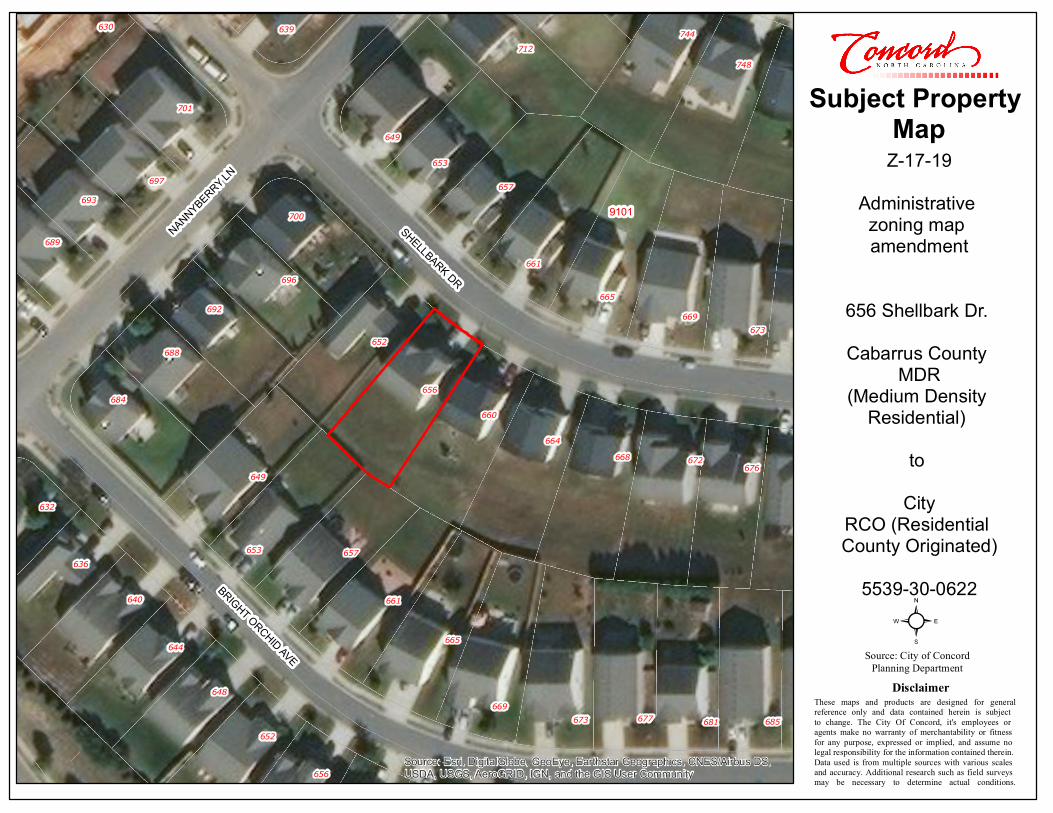
The subject property consists of one (1) parcel, comprising approximately 0.17 acres at 656 Shellbark Dr., North of Zion Church Road E. within the Hallstead Subdivision. The property contains one (1) single family home. The property was recently annexed on August 8th, 2019, to allow the property owners to access city water, sewer and solid waste services. HISTORY
The property was annexed into the City on August 8th, 2019 and a City zoning classification must be applied.
SUMMARY OF REQUEST Subsequent to the annexation of this parcel, zoning must be assigned to the property prior to the owner legally receiving city services. The City is requesting to administratively rezone the subject property from Cabarrus County MDR (Medium Density Residential) to R-CO (Residential County Originated). Concord’s primary corporate limits are surrounding this property, as it is one (1) of thirty eight (38) parcels that were never annexed within the subdivision. Surrounding properties within the subdivision are developed with single-family
Case Z-17-19 2
detached homes and are zoned R-CO (Residential County Originated). The subject property is consistent with surrounding R-CO (Residential County Originated) properties and meets the dimensional standards for that district. Staff has advised the property owner of the proposed zoning classification and corresponding setbacks. The property owner had no objection.
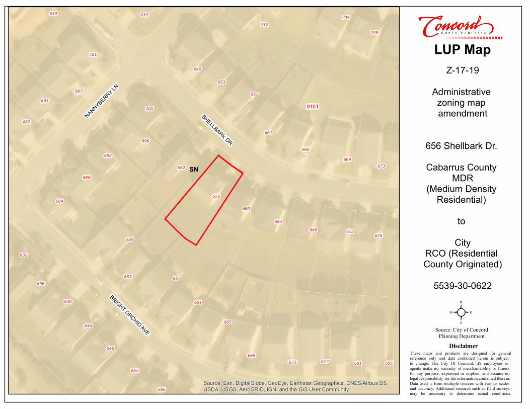
COMPLIANCE WITH 2030 LAND USE PLAN The 2030 Land Use Plan (LUP) designates the subject property as “Suburban Neighborhood” for which R-CO (Residential County Originated) is listed as a compatible zoning district.
From the 2030 Land Use Plan – “Suburban Neighborhoods (SN)”: The Suburban Neighborhood (SN) Future Land Use category includes single-family areas that are formed as subdivisions or communities, with a relatively uniform housing type and density throughout. They may support a variety of single-family detached residential types, from low-density single-family homes to denser formats of smaller single-family homes. In areas designated Suburban Neighborhood, homes are typically oriented interior to the neighborhood and are typically buffered from surrounding development by transitional uses or landscaped areas.
Objective 1.6: Provide a diverse mix and range of housing options throughout the City that will accommodate the current and future needs of the citizens of Concord.
Policy Guidance for Objective 1.6:
· Infill Housing: Promote a variety of compatible infill housing types in areas with access to adequate facilities and services.
Goal 4: Ensure compatibility between neighboring land uses.
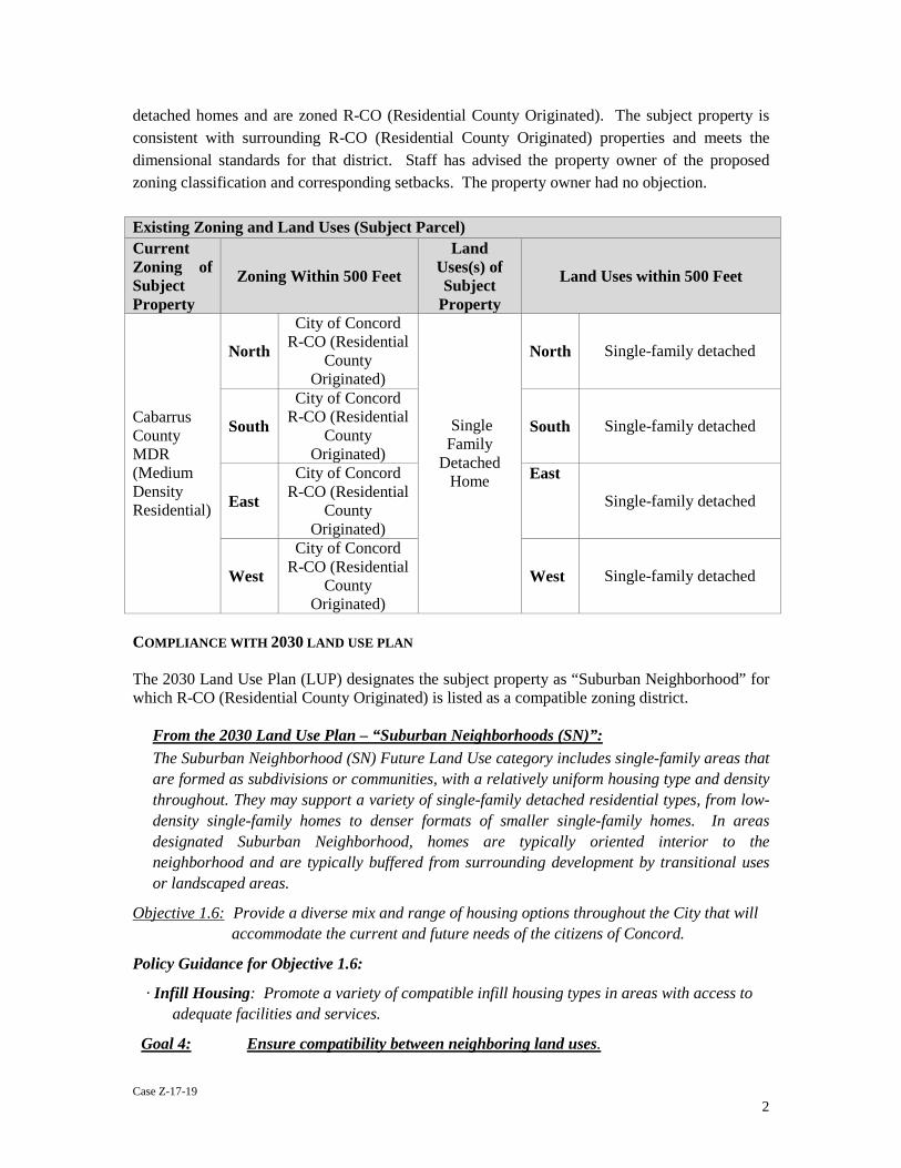
Existing Zoning and Land Uses (Subject Parcel) Current Zoning of Subject Property
Zoning Within 500 Feet
Land Uses(s) of Subject
Property
Land Uses within 500 Feet
Cabarrus County MDR (Medium Density Residential)
North
City of Concord R-CO (Residential
County Originated)
Single Family
Detached Home
North Single-family detached
South
City of Concord R-CO (Residential
County Originated)
South Single-family detached
East
City of Concord R-CO (Residential
County Originated)
East
Single-family detached
West
City of Concord R-CO (Residential
County Originated)
West Single-family detached

Case Z-17-19 3
Objective 4.1: Use a combination of land use transitions, intensity gradients, buffering and design to ensure that land use transitions are compatible.
The following general land use challenges and opportunities in Section 5.2 relate to the proposed amendment.
Ensuring compatibility between neighboring land uses: As the diversity of uses and housing
types increases, the potential for incompatibility increases. To maintain compatibility between adjacent uses, the City will need to ensure that there are seamless transitions between uses which will require a combination of separating certain uses, buffering between uses, and addressing the design, scale, height, orientation and intensity of development as appropriate to the land use transition and the site.
The following goals, objectives and policy guidance relate to the proposed zoning amendment.
SUGGESTED STATEMENT OF CONSISTENCY
• The subject property consists of one (1) parcel, comprising approximately 0.17 acres at 656 Shellbark Dr., North of Zion Church Road E. within the Hallstead Subdivision.
• The property was annexed into the City on August 8th, 2019 and a City zoning classification must be applied.
• The proposed zoning is consistent with the 2030 Land Use Plan (LUP) as RC-O is a
corresponding zoning classification to the “Suburban Neighborhood” Land Use Category. The subject property is located within an established residential neighborhood and the proposed R-CO (Residential County Originated) zoning will limit development to remain a single-family detached home, consistent with the surrounding neighborhoods.
• The zoning amendment is reasonable and in the public interest as it will remain consistent with the existing subdivision, and adjacent, single-family developments to the north, south, east, and west.
SUGGESTED RECOMMENDATION AND CONDITIONS The staff finds the zoning map amendment consistent 2030 Land Use Plan and staff has no objections to the petition. PROCEDURAL CONSIDERATIONS This particular case is a rezoning, which under the CDO, is “legislative” in nature. Legislative hearings DO NOT require the swearing or affirming of witnesses prior to testimony at the public hearing. As the request is not a “Conditional District” no conditions may be applied.
744
748
632
636
640
644
648
649
652
653
656
657
661
665
669673 677 681 685
684
688
689
692
693
696
697
700
701
712
630 639
649
652
653
656
657
660
661
664
665
668
669
672
673
676
NANNYBERRY LNSHELLBARK DR
BRIGHT ORCHID AVE
SN
Source: Esri, DigitalGlobe, GeoEye, Earthstar Geographics, CNES/Airbus DS,USDA, USGS, AeroGRID, IGN, and the GIS User Community
²
Z-17-19Administrative zoning map amendment
656 Shellbark Dr. Cabarrus County
MDR(Medium Density
Residential) to
CityRCO (Residential County Originated)
5539-30-0622
Source: City of ConcordPlanning Department
These maps and products are designed for generalreference only and data contained herein is subject to change. The City Of Concord, it's employees or agents make no warranty of merchantability or fitness for any purpose, expressed or implied, and assume no legal responsibility for the information contained therein. Data used is from multiple sources with various scales and accuracy. Additional research such as field surveys may be necessary to determine actual conditions.
Disclaimer
LUP Map
9101

744
748
632
636
640
644
648
649
652
653
656
657
661
665
669673 677 681 685
684
688
689
692
693
696
697
700
701
712
630 639
649
652
653
656
657
660
661
664
665
668
669
672
673
676
NANNYBERRY LN
SHELLBARK DR
BRIGHT ORCHID AVE
County MDR
CountyMDR
CountyMDR
CountyMDR
CountyMDR
CountyMDR
CountyMDR
CountyMDR
CountyMDR
CountyMDR
CountyMDR
Source: Esri, DigitalGlobe, GeoEye, Earthstar Geographics, CNES/Airbus DS,USDA, USGS, AeroGRID, IGN, and the GIS User Community
²
Z-17-19Administrative zoning map amendment
656 Shellbark Dr. Cabarrus County
MDR(Medium Density
Residential) to
CityRCO (Residential County Originated)
5539-30-0622
Source: City of ConcordPlanning Department
These maps and products are designed for generalreference only and data contained herein is subject to change. The City Of Concord, it's employees or agents make no warranty of merchantability or fitness for any purpose, expressed or implied, and assume no legal responsibility for the information contained therein. Data used is from multiple sources with various scales and accuracy. Additional research such as field surveys may be necessary to determine actual conditions.
Disclaimer
Zoning Map
9101
744
748
632
636
640
644
648
649
652
653
656
657
661
665
669673 677 681 685
684
688
689
692
693
696
697
700
701
712
630 639
649
652
653
656
657
660
661
664
665
668
669
672
673
676
NANNYBERRY LNSHELLBARK DR
BRIGHT ORCHID AVE
Source: Esri, DigitalGlobe, GeoEye, Earthstar Geographics, CNES/Airbus DS,USDA, USGS, AeroGRID, IGN, and the GIS User Community
²
Z-17-19Administrative zoning map amendment
656 Shellbark Dr. Cabarrus County
MDR(Medium Density
Residential) to
CityRCO (Residential County Originated)
5539-30-0622
Source: City of ConcordPlanning Department
These maps and products are designed for generalreference only and data contained herein is subject to change. The City Of Concord, it's employees or agents make no warranty of merchantability or fitness for any purpose, expressed or implied, and assume no legal responsibility for the information contained therein. Data used is from multiple sources with various scales and accuracy. Additional research such as field surveys may be necessary to determine actual conditions.
Disclaimer
Subject Property Map
9101