Embed Size (px)
Citation preview
Dataset Documentation
Dataset Name:
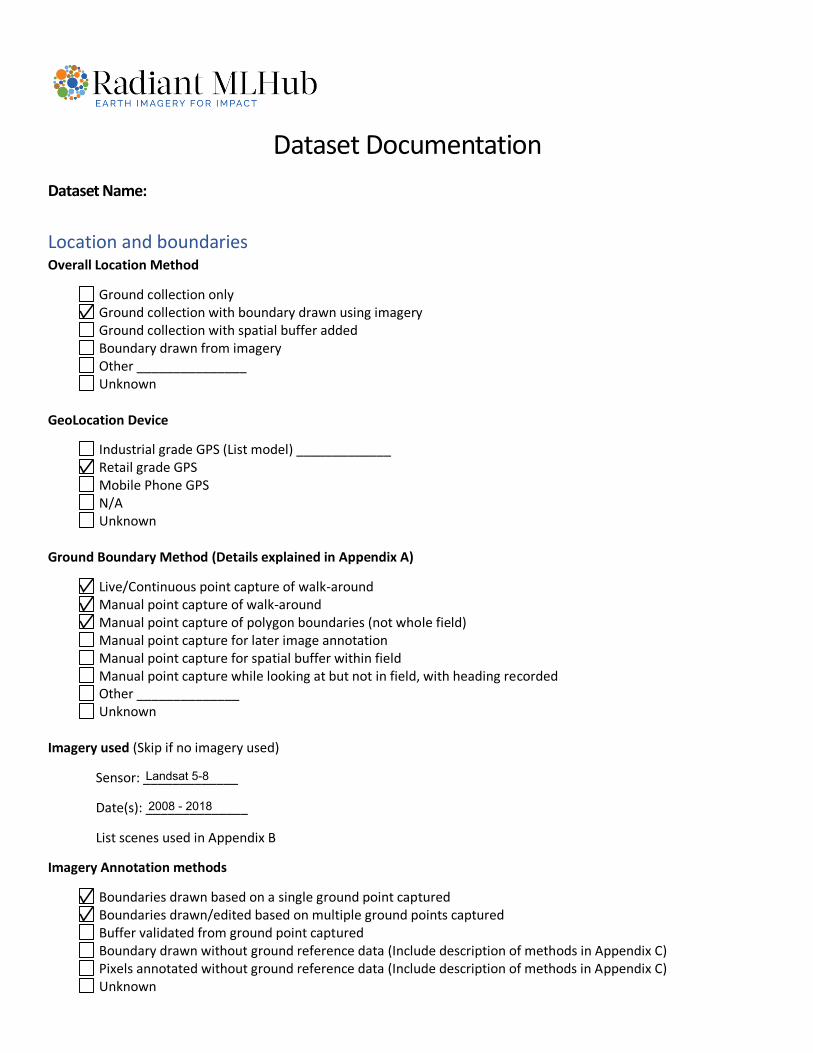
Location and boundaries Overall Location Method
Ground collection only Ground collection with boundary drawn using imagery Ground collection with spatial buffer added Boundary drawn from imagery Other _______________ Unknown
GeoLocation Device
Industrial grade GPS (List model) _____________ Retail grade GPS Mobile Phone GPS N/A Unknown
Ground Boundary Method (Details explained in Appendix A)
Live/Continuous point capture of walk-around Manual point capture of walk-around Manual point capture of polygon boundaries (not whole field) Manual point capture for later image annotation Manual point capture for spatial buffer within field Manual point capture while looking at but not in field, with heading recorded Other ______________ Unknown
Imagery used (Skip if no imagery used)
Sensor: _____________
Date(s): ______________
List scenes used in Appendix B
Imagery Annotation methods
Boundaries drawn based on a single ground point captured Boundaries drawn/edited based on multiple ground points captured Buffer validated from ground point captured Boundary drawn without ground reference data (Include description of methods in Appendix C) Pixels annotated without ground reference data (Include description of methods in Appendix C) Unknown
Landsat 5-8
2008 - 2018
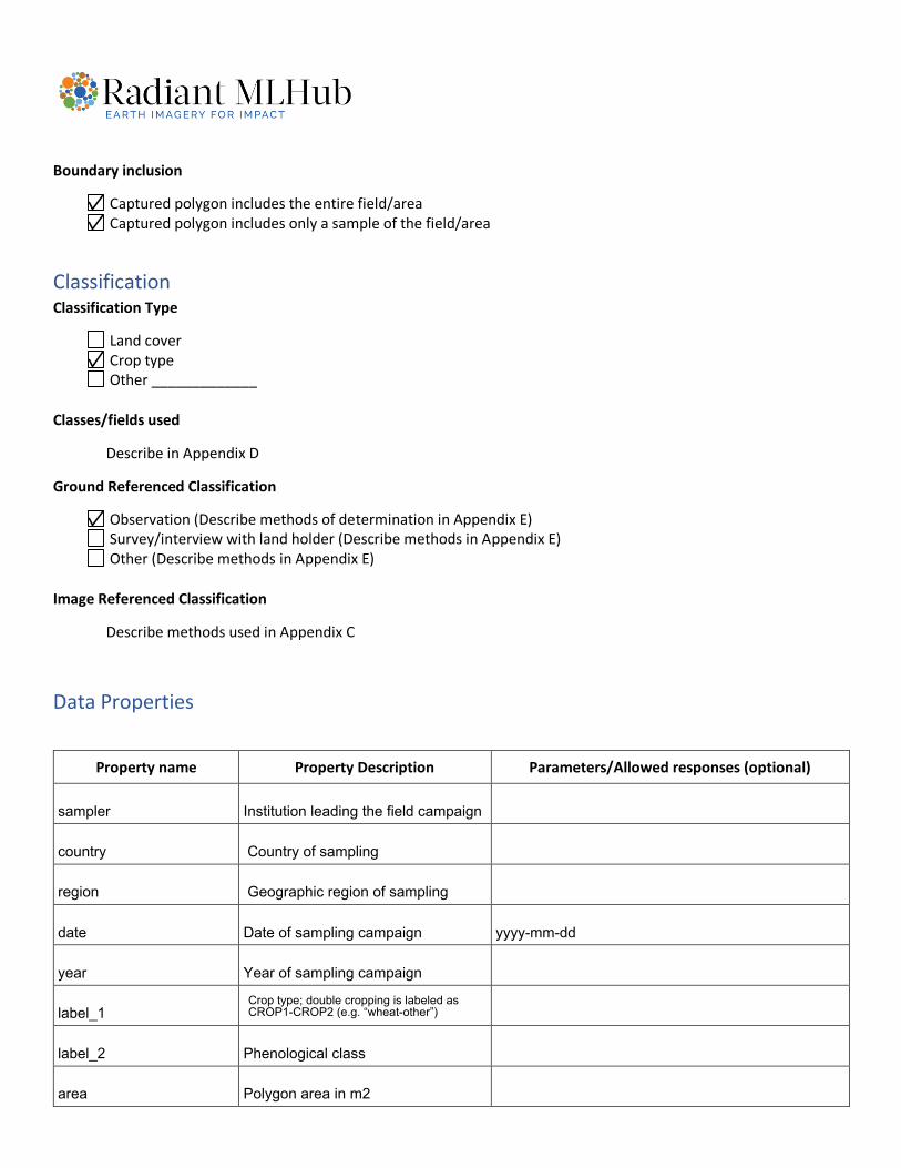
Boundary inclusion
Captured polygon includes the entire field/area Captured polygon includes only a sample of the field/area
Classification Classification Type
Land cover Crop type Other _____________
Classes/fields used
Describe in Appendix D
Ground Referenced Classification
Observation (Describe methods of determination in Appendix E) Survey/interview with land holder (Describe methods in Appendix E) Other (Describe methods in Appendix E)
Image Referenced Classification
Describe methods used in Appendix C
Data Properties
Property name Property Description Parameters/Allowed responses (optional)
Institution leading the field campaign
Country of sampling
Geographic region of sampling region
country
sampler
date
year
label_1
label_2
area
yyyy-mm-ddDate of sampling campaign
Year of sampling campaign
Crop type; double cropping is labeled as CROP1-CROP2 (e.g. “wheat-other”)
Phenological class
Polygon area in m2
Appendix A: Describe the method of geographic ground data collection
Appendix B: List imagery scenes used for annotation (ideally also included in metadata)
Appendix C: Describe how boundaries and classes were determined without ground reference data
Appendix D: List all top-level classes or the classification guidance used
Polygons were drawn from the GPS points collected on the field through image interpretation, relying on multi-temporal, very high-resolution satellite imagery from Google Earth (GE). The drawin polygons avoid non-vegetated areas,and samples with an unclear land cover (e.g. mixed crops), where exluded, as well as those with no valid GE Data due to the lack of observations or heavy cloud-cover.
All available collection 1 Landsat Data (i.e. Landsat 4, 5, 7 and 8) within a buffer of 2 months of each sampling year (i.e. 2008, 2011, 2015, 2016, 2017 and 2018) where used in the evaluation of crop type labels.
The top level class scheme (referred to as "label_2" in the present dataset) lists phenological classes, highlighting differences in the growth patterns of different crops and certain management practices:- "winter"- "summer"- "double" (cropping)- "permanent"- "fallow"- "unclear" (i.e. no distinguishible phenological cycle)
Appendix E: Describe methods for determining classes based on direct/ground observation
Include any additional information/extra space as Appendix F+
The classification of samples into different crop types was performed through visual interpretation on the field. Then, the validity of the assigned classes was tested against per-field, high-resolution, equidistant time-series of Normalized Difference Vegetation Index (NDVI). This step helped identify inconsistencies in class assignments in light of expert and data-driven knowledge on the phenological behavior of individual crop types.
For details on the methodology, please consult the publication dedicated to this dataset (https://www.nature.com/articles/s41597-020-00591-2).


![Stanford University · 3.1 Dataset SQuAD dataset is a machine comprehension dataset on Wikipedia articles with more than 100,000 questions [1]. The dataset is randomly partitioned](https://img.pdfslide.us/doc/110x75/602d75745c2a607275039f53/stanford-university-31-dataset-squad-dataset-is-a-machine-comprehension-dataset.jpg)