Embed Size (px)
Citation preview
How to Acquire and Subset Sentinel-1 InSAR
Data with Harmony and the GDAL Subsetter
ASF has pre-processed Sentinel-1 Interferograms (S1 InSAR) available for download. This recipe goes
through the basic steps of constructing a Harmony request URL to find S1 InSAR data that falls within an
area and time period of interest and perform variable and spatial subsetting on the data using the GDAL
Subsetter.
Contents
Background 2
Sentinel-1 InSAR Products (ARIA) 2
Harmony 2
GDAL Subsetter 2
Prerequisites 3
URL Construction 4
Standard Components 4
Optional Components 5
Processing Steps 5
7 April 2021 v.1.0 | 1
UAF is an AA/EO employer and educational institution and prohibits illegal discrimination against any
individual: www.alaska.edu/nondiscrimination
Background
Sentinel-1 InSAR Products (ARIA)
The Alaska Satellite Facility (ASF) has a targeted collection of pre-processed Sentinel-1 Interferograms (S1
InSAR) available for download. These products are generated by Jet Propulsion Laboratory’s ARIA Science
Data program, and can be downloaded from ASF Data Search - Vertex in their original netCDF format, or
as individual GeoTIFF files. The individual products and netCDF layers include Unwrapped Phase,
Coherence, Amplitude, and Connected Components.
In some cases, the spatial extent of these Sentinel-1 InSAR data products is larger than the user’s area of
interest, or the user may only be interested in a subset of the variables (data layers) included in the
netCDF file. By subsetting the dataset spatially and extracting only the netCDF variables of interest
before the product is downloaded, the size of the download can be significantly reduced.
Harmony
Harmony is a cloud-based data transformation framework that can be leveraged by different NASA data
providers to offer a streamlined user experience regardless of the data source. NASA’s Earth Observing
System Data and Information System (EOSDIS) supports 12 different Distributed Active Archive Centers
(DAACs), each of which specializes in archiving and serving particular data types or topics. While datasets
can differ significantly from one DAAC to another, some functionality can be consistently applied to a
wide range of these datasets. Developing and sharing services in a common framework that can be used
by all of the DAACs reduces duplication of effort and offers a more consistent experience for data
consumers.
GDAL Subsetter
The GDAL Subsetter is a Harmony service developed by ASF that is currently configured for use with
specific collections of S1 InSAR, UAVSAR and AVNIR-2 data with netCDF and GeoTIFF file formats. It
allows users to extract spatial and/or variable subsets and to reproject the data if desired.
By accessing the GDAL Subsetter through Harmony, users can find S1 InSAR data that is within their area
of interest and a temporal range, then generate products that are subsets of the variables and/or spatial
extent of the original data products. Subset products are a fraction of the original data volume and can
be downloaded more quickly and managed more easily. This recipe goes through the basic steps of
constructing a Harmony request URL to find S1 InSAR data that falls within an area and time period of
interest and perform variable and spatial subsetting on the data.
7 April 2021 v.1.0 | 2
UAF is an AA/EO employer and educational institution and prohibits illegal discrimination against any
individual: www.alaska.edu/nondiscrimination
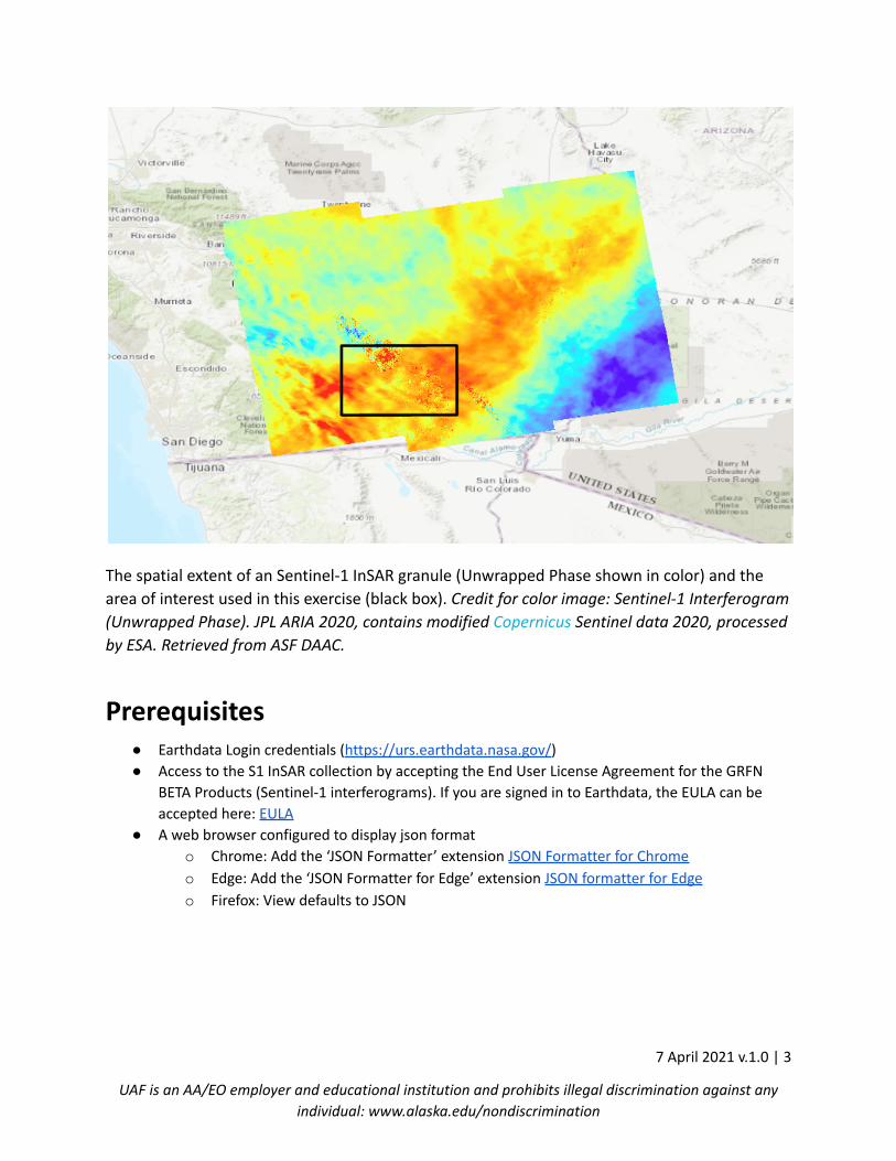
The spatial extent of an Sentinel-1 InSAR granule (Unwrapped Phase shown in color) and the
area of interest used in this exercise (black box). Credit for color image: Sentinel-1 Interferogram
(Unwrapped Phase). JPL ARIA 2020, contains modified Copernicus Sentinel data 2020, processed
by ESA. Retrieved from ASF DAAC.
Prerequisites● Earthdata Login credentials (https://urs.earthdata.nasa.gov/)
● Access to the S1 InSAR collection by accepting the End User License Agreement for the GRFN
BETA Products (Sentinel-1 interferograms). If you are signed in to Earthdata, the EULA can be
accepted here: EULA
● A web browser configured to display json format
o Chrome: Add the ‘JSON Formatter’ extension JSON Formatter for Chrome
o Edge: Add the ‘JSON Formatter for Edge’ extension JSON formatter for Edge
o Firefox: View defaults to JSON
7 April 2021 v.1.0 | 3
UAF is an AA/EO employer and educational institution and prohibits illegal discrimination against any
individual: www.alaska.edu/nondiscrimination
URL Construction
Standard Components
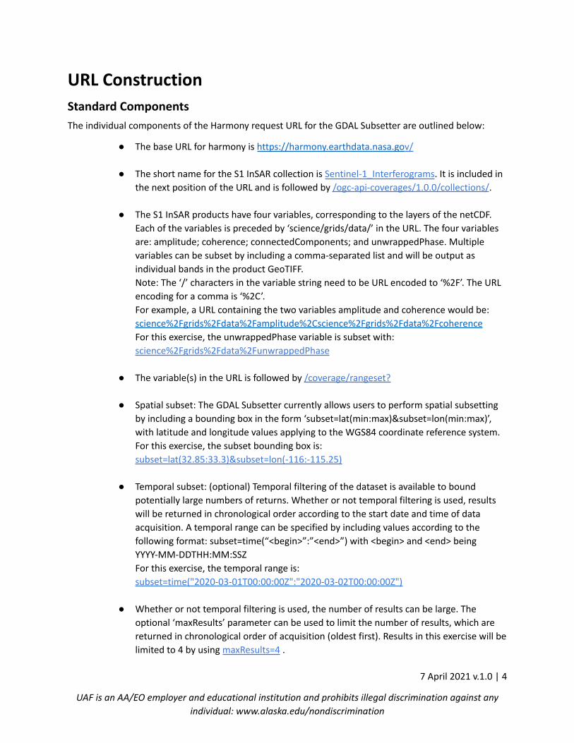
The individual components of the Harmony request URL for the GDAL Subsetter are outlined below:
● The base URL for harmony is https://harmony.earthdata.nasa.gov/
● The short name for the S1 InSAR collection is Sentinel-1_Interferograms. It is included in
the next position of the URL and is followed by /ogc-api-coverages/1.0.0/collections/.
● The S1 InSAR products have four variables, corresponding to the layers of the netCDF.
Each of the variables is preceded by ‘science/grids/data/’ in the URL. The four variables
are: amplitude; coherence; connectedComponents; and unwrappedPhase. Multiple
variables can be subset by including a comma-separated list and will be output as
individual bands in the product GeoTIFF.
Note: The ‘/’ characters in the variable string need to be URL encoded to ‘%2F’. The URL
encoding for a comma is ‘%2C’.
For example, a URL containing the two variables amplitude and coherence would be:
science%2Fgrids%2Fdata%2Famplitude%2Cscience%2Fgrids%2Fdata%2Fcoherence
For this exercise, the unwrappedPhase variable is subset with:
science%2Fgrids%2Fdata%2FunwrappedPhase
● The variable(s) in the URL is followed by /coverage/rangeset?
● Spatial subset: The GDAL Subsetter currently allows users to perform spatial subsetting
by including a bounding box in the form ‘subset=lat(min:max)&subset=lon(min:max)’,
with latitude and longitude values applying to the WGS84 coordinate reference system.
For this exercise, the subset bounding box is:
subset=lat(32.85:33.3)&subset=lon(-116:-115.25)
● Temporal subset: (optional) Temporal filtering of the dataset is available to bound
potentially large numbers of returns. Whether or not temporal filtering is used, results
will be returned in chronological order according to the start date and time of data
acquisition. A temporal range can be specified by including values according to the
following format: subset=time(“<begin>”:”<end>”) with <begin> and <end> being
YYYY-MM-DDTHH:MM:SSZ
For this exercise, the temporal range is:
subset=time("2020-03-01T00:00:00Z":"2020-03-02T00:00:00Z")
● Whether or not temporal filtering is used, the number of results can be large. The
optional ‘maxResults’ parameter can be used to limit the number of results, which are
returned in chronological order of acquisition (oldest first). Results in this exercise will be
limited to 4 by using maxResults=4 .
7 April 2021 v.1.0 | 4
UAF is an AA/EO employer and educational institution and prohibits illegal discrimination against any
individual: www.alaska.edu/nondiscrimination
Optional Components
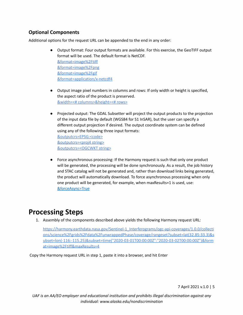
Additional options for the request URL can be appended to the end in any order:
● Output format: Four output formats are available. For this exercise, the GeoTIFF output
format will be used. The default format is NetCDF.
&format=image%2Ftiff
&format=image%2Fpng
&format=image%2Fgif
&format=application/x-netcdf4
● Output image pixel numbers in columns and rows: If only width or height is specified,
the aspect ratio of the product is preserved.
&width=<# columns>&height=<# rows>
● Projected output: The GDAL Subsetter will project the output products to the projection
of the input data file by default (WGS84 for S1 InSAR), but the user can specify a
different output projection if desired. The output coordinate system can be defined
using any of the following three input formats:
&outputcrs=EPSG:<code>
&outputcrs=<proj4 string>
&outputcrs=<OGCWKT string>
● Force asynchronous processing: If the Harmony request is such that only one product
will be generated, the processing will be done synchronously. As a result, the job history
and STAC catalog will not be generated and, rather than download links being generated,
the product will automatically download. To force asynchronous processing when only
one product will be generated, for example, when maxResults=1 is used, use:
&forceAsync=True
Processing Steps1. Assembly of the components described above yields the following Harmony request URL:
https://harmony.earthdata.nasa.gov/Sentinel-1_Interferograms/ogc-api-coverages/1.0.0/collecti
ons/science%2Fgrids%2Fdata%2FunwrappedPhase/coverage/rangeset?subset=lat(32.85:33.3)&s
ubset=lon(-116:-115.25)&subset=time("2020-03-01T00:00:00Z":"2020-03-02T00:00:00Z")&form
at=image%2Ftiff&maxResults=4
Copy the Harmony request URL in step 1, paste it into a browser, and hit Enter
7 April 2021 v.1.0 | 5
UAF is an AA/EO employer and educational institution and prohibits illegal discrimination against any
individual: www.alaska.edu/nondiscrimination
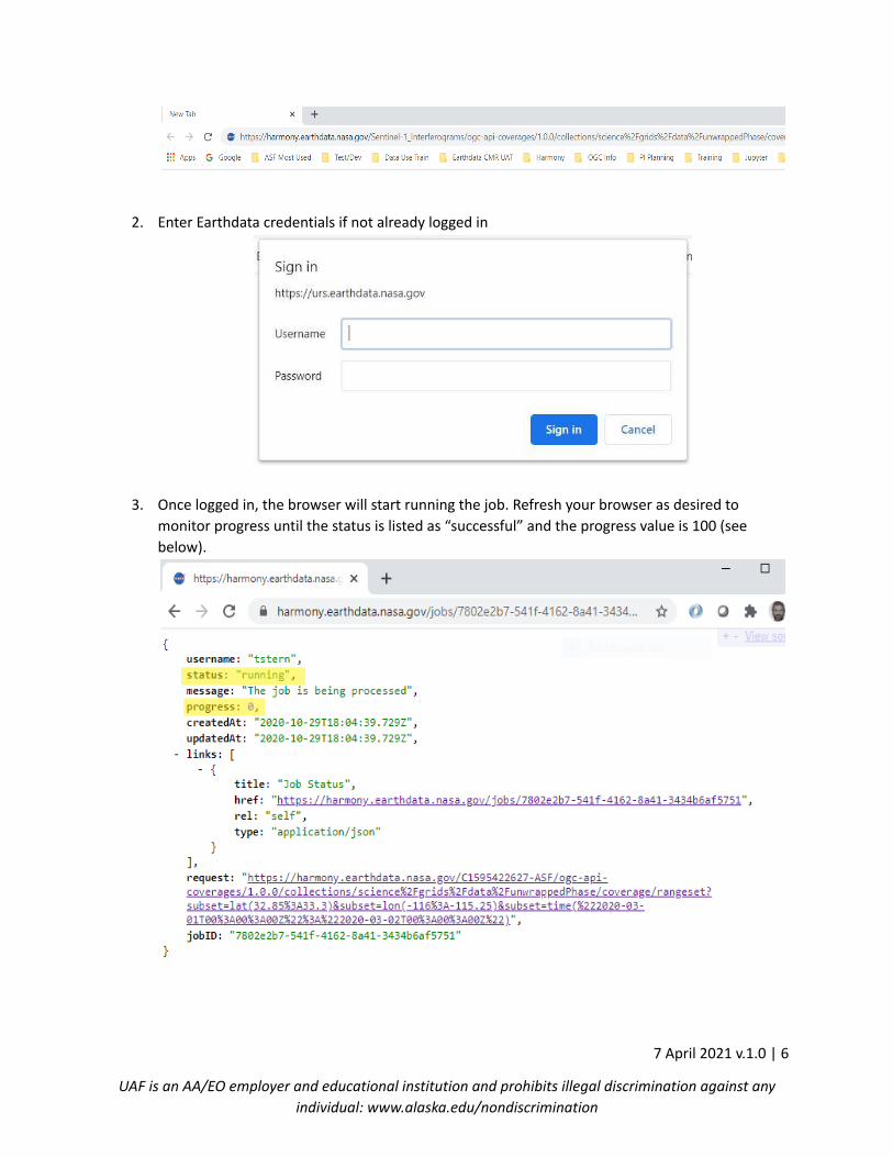
2. Enter Earthdata credentials if not already logged in
3. Once logged in, the browser will start running the job. Refresh your browser as desired to
monitor progress until the status is listed as “successful” and the progress value is 100 (see
below).
7 April 2021 v.1.0 | 6
UAF is an AA/EO employer and educational institution and prohibits illegal discrimination against any
individual: www.alaska.edu/nondiscrimination
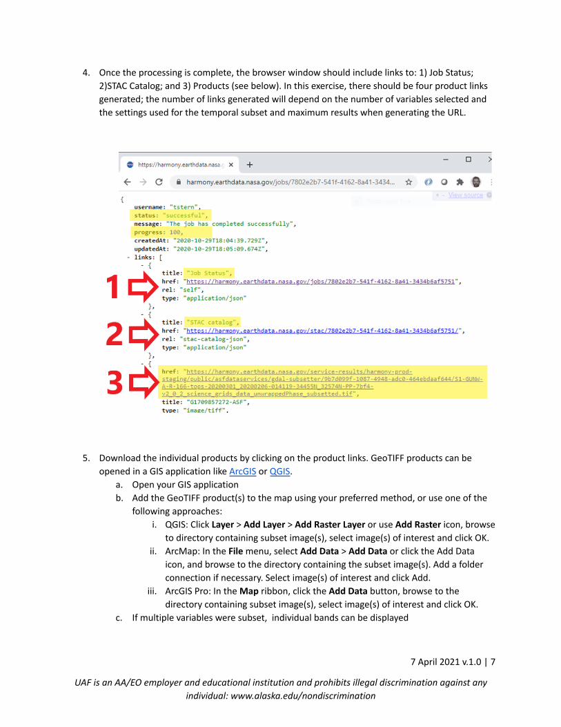
4. Once the processing is complete, the browser window should include links to: 1) Job Status;
2)STAC Catalog; and 3) Products (see below). In this exercise, there should be four product links
generated; the number of links generated will depend on the number of variables selected and
the settings used for the temporal subset and maximum results when generating the URL.
5. Download the individual products by clicking on the product links. GeoTIFF products can be
opened in a GIS application like ArcGIS or QGIS.
a. Open your GIS application
b. Add the GeoTIFF product(s) to the map using your preferred method, or use one of the
following approaches:
i. QGIS: Click Layer > Add Layer > Add Raster Layer or use Add Raster icon, browse
to directory containing subset image(s), select image(s) of interest and click OK.
ii. ArcMap: In the File menu, select Add Data > Add Data or click the Add Data
icon, and browse to the directory containing the subset image(s). Add a folder
connection if necessary. Select image(s) of interest and click Add.
iii. ArcGIS Pro: In the Map ribbon, click the Add Data button, browse to the
directory containing subset image(s), select image(s) of interest and click OK.
c. If multiple variables were subset, individual bands can be displayed
7 April 2021 v.1.0 | 7
UAF is an AA/EO employer and educational institution and prohibits illegal discrimination against any
individual: www.alaska.edu/nondiscrimination
i. QGIS: Right click on the product in the table of contents > Properties >
Symbology. On the symbology tab, for Render Type select Singleband Grey and
from Grey band select the variable band to display.
ii. ArcMap: Right click on the product in the table of contents > Properties >
Symbology and select Show > Stretched and select the variable to display from
the Band dropdown > Apply > OK
iii. ArcGIS Pro: Right click on the product in the table of contents > Symbology.
Under Primary Symbology select Stretch, then select the variable to display
from the Band dropdown and close the Symbology window.
Note: Using symbology to display individual bands of a multi-band subsetted
product is not currently working as expected in some ArcGIS Pro versions. If you
have difficulty visualizing bands other than the first one with the Stretch
approach, you can use an RGB symbology and set all of the bands to the band
you would like to visualize. Alternatively, select Geoprocessing from the View
tab, and in the Geoprocessing pane select Data Management Tools > Layers
and Table Views > Make Raster Layer. In the tool, for Input raster, navigate to
the multi-band GeoTIFF, name the Output raster layer, and from the Bands
dropdown select the band you want to display and click Run.
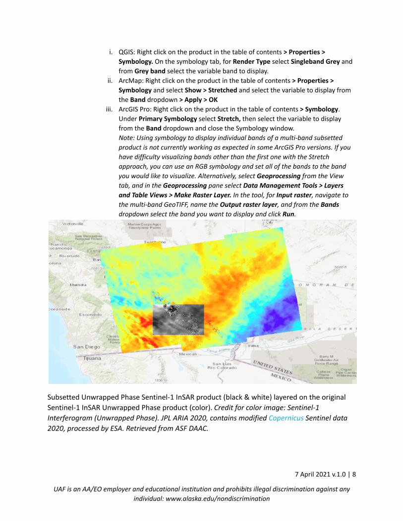
Subsetted Unwrapped Phase Sentinel-1 InSAR product (black & white) layered on the original
Sentinel-1 InSAR Unwrapped Phase product (color). Credit for color image: Sentinel-1
Interferogram (Unwrapped Phase). JPL ARIA 2020, contains modified Copernicus Sentinel data
2020, processed by ESA. Retrieved from ASF DAAC.
7 April 2021 v.1.0 | 8
UAF is an AA/EO employer and educational institution and prohibits illegal discrimination against any
individual: www.alaska.edu/nondiscrimination
6. Users can revisit their job history and access previously processed products at
https://harmony.earthdata.nasa.gov/jobs/
7. The STAC catalog can be accessed by clicking on the link in the job history. The catalog lists
spatial and temporal information for the products that were generated.
7 April 2021 v.1.0 | 9
UAF is an AA/EO employer and educational institution and prohibits illegal discrimination against any
individual: www.alaska.edu/nondiscrimination


![Reading Raster Data with GDAL - Utah State Universitychrisg/python/2009/lectures/...OS Python week 4: Reading raster data [1] Open Source RS/GIS Python Week 4 GDAL • Supports about](https://img.pdfslide.us/doc/110x75/5ec9b44cd8461578ed461ae7/reading-raster-data-with-gdal-utah-state-university-chrisgpython2009lectures.jpg)