Embed Size (px)
Citation preview
Volume 72, No. 1 • 2012 A NEWSLETTER OF THE OKLAHOMA GEOLOGICAL SURVEYThe University of Oklahoma MEWBOURNE COLLEGE OF EARTH & ENERGY
Volume 72Volume 7
Dan T. Boyd, Qatar Petroleum
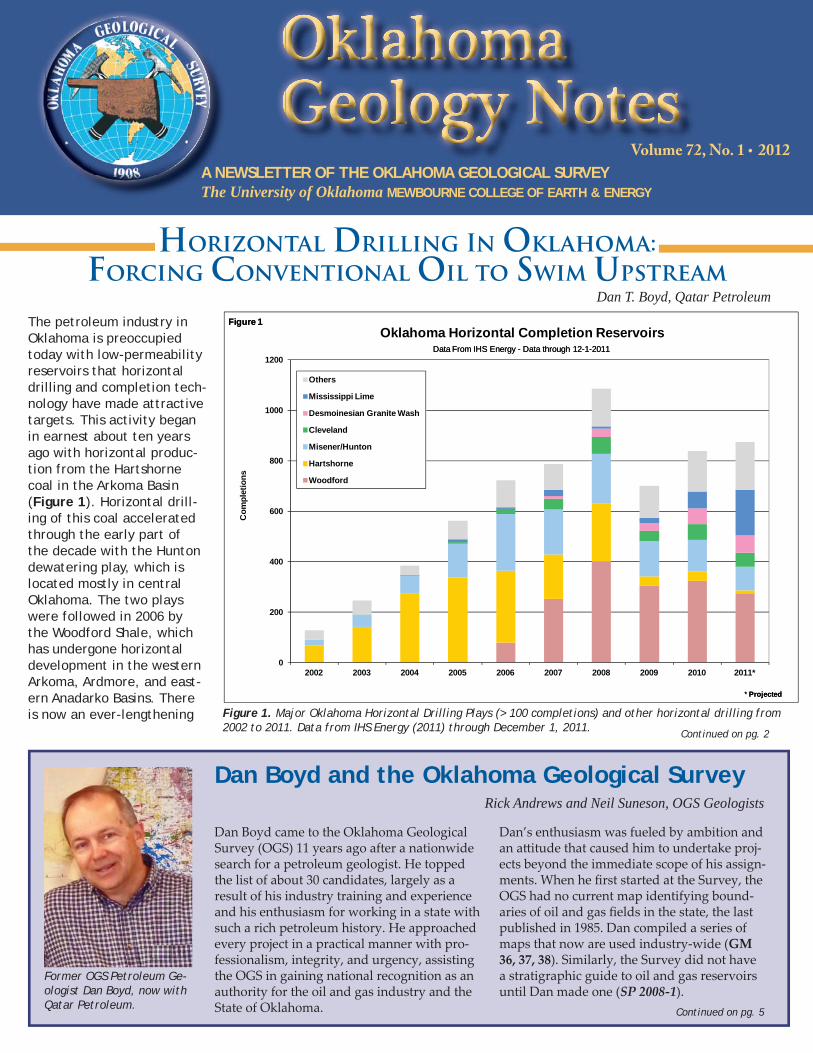
The petroleum industry in Oklahoma is preoccupied today with low-permeability reservoirs that horizontal drilling and completion tech-nology have made attractive targets. This activity began in earnest about ten years ago with horizontal produc-tion from the Hartshorne coal in the Arkoma Basin (Figure 1). Horizontal drill-ing of this coal accelerated through the early part of the decade with the Hunton dewatering play, which is located mostly in central Oklahoma. The two plays were followed in 2006 by the Woodford Shale, which has undergone horizontal development in the western Arkoma, Ardmore, and east-ern Anadarko Basins. There is now an ever-lengthening
Horizontal Drilling In Oklahoma: Forcing Conventional Oil to Swim Upstream
Continued on pg. 2
Dan Boyd and the Oklahoma Geological SurveyRick Andrews and Neil Suneson, OGS Geologists
Dan Boyd came to the Oklahoma Geological Survey (OGS) 11 years ago after a nationwide search for a petroleum geologist. He topped the list of about 30 candidates, largely as a result of his industry training and experience and his enthusiasm for working in a state with such a rich petroleum history. He approached every project in a practical manner with pro-fessionalism, integrity, and urgency, assisting the OGS in gaining national recognition as an authority for the oil and gas industry and the State of Oklahoma.
Dan’s enthusiasm was fueled by ambition and an att itude that caused him to undertake proj-ects beyond the immediate scope of his assign-ments. When he fi rst started at the Survey, the OGS had no current map identifying bound-aries of oil and gas fi elds in the state, the last published in 1985. Dan compiled a series of maps that now are used industry-wide (GM 36, 37, 38). Similarly, the Survey did not have a stratigraphic guide to oil and gas reservoirs until Dan made one (SP 2008-1).
Continued on pg. 5
0
200
400
600
800
1000
1200
2002 2003 2004 2005 2006 2007 2008 2009 2010 2011*
Com
plet
ions
Oklahoma Horizontal Completion Reservoirs
Others
Mississippi Lime
Desmoinesian Granite Wash
Cleveland
Misener/Hunton
Hartshorne
Woodford
Data From IHS Energy - Data through 12-1-2011
* Projected
Figure 1
Data From IHS Energy - Data through 12-1-2011
* Projected
Figure 1
Figure 1. Major Oklahoma Horizontal Drilling Plays (> 100 completions) and other horizontal drilling from 2002 to 2011. Data from IHS Energy (2011) through December 1, 2011.
Former OGS Petroleum Ge-ologist Dan Boyd, now with Qatar Petroleum.
Oklahoma Geology Notes • v. 72, No. 1 • 20122
In This Issue. . .Horizontal Drilling in Oklahoma: Forcing Conventional Oil to 1 Swim Upstream Dan Boyd and the Oklahoma Geological Survey 1From the Director... 2Oklahoma Structural and Stratigraphic Oil & Gas Workshop 7Oklahoma Geological Survey Participates in the Oklahoma Aggregates 9 Association 11th Annual Meeting and Field Trip Aggregates Day at the State Capitol 13 Earthquake Report 4th Quarter 2011 14
2012 has begun on a positive note with the exception of the departure of Dan Boyd to assume a leadership posi-tion in Qatar. He made many contributions over the years that are a legacy to his time with us. His leadership on our eff orts to support the Energy Libraries Online project will have a long-lasting impact. We greatly appreciate his 11 years with us and wish him nothing but the best in his new endeavor. He has been sending us pictures of the skyscrapers from his offi ce window in Doha, the capitol.
Ken Johnson is receiving an award that not only recog-nizes his many years of service to the OGS (11 as Asso-ciate Director) but also his service to the Association of American State Geologists (AASG). He will be awarded a Distinguished Service Award at the annual AASG meet-ing this summer. Ken has been retired from OGS for over 10 years, but we continue to be able to tap his many years of experience and broad knowledge of Oklahoma geol-ogy.
We are really excited by the improvements at the Okla-homa Petroleum Information Center (OPIC). The fi rst
From the Director...G. Randy Keller, Oklahoma State Geologist
OKLAHOMA GEOLOGY NOTES, ISSN 0030-1736, is published quarterly by the Oklahoma Geological Sur vey, 100 E. Boyd, Room N-131, Norman, OK 73019. Director: G. Randy Keller; Editor: Sue Britton CritesThis publication, printed by Oklahoma Geological Survey Printing, Norman, Okla homa, is issued by the Oklahoma Geological Survey as authorized by Title 70, Oklahoma Statutes 1981, Section 3310, and Title 74, Oklahoma Statutes 1981, Sections 231–238. 2,600 copies have been prepared for distri bution at a cost of $1,105 to the taxpayers of the State of Oklahoma. Copies have been deposited with the Pub lications Clearinghouse of the Oklahoma Department of Li braries.
Horizontal Drilling In Oklahoma...continued
phase of the re-roofi ng proj-ect is complete, the state of our voluminous paper re-cords continues to improve and become more digital, and new equipment to ana-lyze cores and cutt ings con-tinues to arrive. The really exciting development is the completion of the core view-ing room. It is simply won-derful with great lighting, air conditioning and heat-ing, and numerous other amenities. This is all thanks to the generosity of Devon Energy.
The earthquake activity in Oklahoma continues to draw a lot of national att ention and keeps us on our toes. We making further improvement to our seismic network, and Oklahoma is now home to 5 broadband state-of-the-art seismic stations.
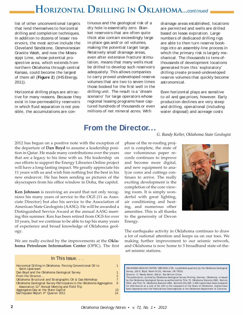
list of other unconventional targets that lend themselves to horizontal drilling and completion techniques. In addition to dozens of lesser res-ervoirs, the most active include the Cleveland Sandstone, Desmoinesian Granite Wash, and now the Missis-sippi Lime, whose potential pro-spective area, which extends from northern Oklahoma through central Kansas, could become the largest of them all (Figure 2) (IHS Energy, 2011).
Horizontal drilling plays are attrac-tive for many reasons. Because they exist in low-permeability reservoirs in which fl uid separation is not pos-sible, the accumulations are con-
tinuous and the geological risk of a dry hole is essentially zero. Blan-ket reservoirs that are often quite thick also contain exceedingly large in-place gas and/or oil volumes, making the potential target large. Relatively small drainage areas, even after extensive fracture stimu-lation, means that many wells must be drilled to develop such reservoirs adequately. This allows companies to carry proved undeveloped reserve volumes that are two to seven times those booked for the fi rst well in the drilling unit. The result is a ‘dream scenario’ for large operators whose regional leasing programs have cap-tured hundreds of thousands or even millions of net mineral acres. With
drainage areas established, locations are permitted and wells are drilled based on lease expiration. Large numbers of dedicated drilling rigs are able to then turn reserve book-ings into an assembly-line process in which the primary risk is largely me-chanical. The thousands to tens-of-thousands of development locations generated from this ‘exploratory’ drilling create proved-undeveloped reserve volumes that quickly become astronomical.
Even horizontal plays are sensitive to oil and gas prices, however. Early production declines are very steep and drilling, operational (including water disposal) and acreage costs
3Oklahoma Geology Notes • v. 72, No. 1 • 2012
CIMARRON TE AX S BEAVERHAR ERP
WOODS
WO DWARDOELLIS
ROG RE
MI LL S
DE YWE
C S ERU T
E MB CKHA
W SH AA IT
G EERR
CJA KSON
LTI LMAN
O OC TT N
EJEFF RSON
S E ENST PH
OM NCHC A E
KIOWA
DOCAD
GRADY
L LA FA FA
RMAJO
G ANR T
GARFIE DL
BLAINE
KINGFISHER
C DIANA AN
KAY
OSAGE
P W EA NE
PAYNE
OMOKLAH A
HA
MN
RO
L
AN
CE
VE
L
D
cC
ML
AIN
GA
RIN
V
M RAYUR
CARTER
LOVE
AM
RSH
ALL
J S ONOHN T
BR ANY
ATOKA
HC OCTAW
McCU TAINR
PUSHMATA AH
CO
AL
PONT TOCO
PT
WA
TO
ME
OT
A
I
OS
EM
IN
LE
OLLINC N
HU
GH
ES
OKF SKEU E
CR KEE
WA
SH
IN
GT
ON
NOWATACR IGA
AOTT WA
EA
DL
AW
RE
M SAYE
OGERR S
ATULS
WAGONER CHEROKEE
ADAIR
OK
MU
LG
EE
KOG EMUS E
SEQUOYAH
LE FLORELATIMER
PTT
BR
IS
UG
McINTOSH
A KE LH S L
1E 2 3 4 5 6 7 8 9 10 11 12 13 14 15 16 17 18 19 20 21 22 23 24 25 26 27 E 25 24 23 22 21 20 19 18 17 16 15 14 13 12 11 10 9 8 7 6 5 4 3 2W 1W1E 2 4 5 6 7 8 9 10 11 12 13 14 15 16 17 18 19 20 21 22 23 243
28
W26 25
1N
2
3
4
5
6
103°
73 °10 °2
101°100°
99 ° 98° 97° 96°95°
37°
36°
35°
34°
01 3°102°
102°
63 °
53 °
100°
99°
98°
34°
97° 96°95°
G
G
G
G
GG
G
G
G
G
GGG
G GGG
G
GGG
G
G
G
G
G
G
G
GG
G
G
G
G
G
GG
G
G
G
G
G
G
G
GGGG
G
GGG
G
G
G
G
GGG
G G
G
G
G
G
GGG
G
GG
G
G
GG
GG
G
GG
G G
GG
G
G
G
G
G
GGGG
GGGG G
G
GG
GGG
GGG
GG
G
G
G
G
G
G
G G
G
GGG
GG
G
GG
G
G
G
G
G
G
G
G
G
GG
G
GG
G GGG GGGGG
G
G
G
GG
GGG
GGG
G
GGG
GGG
GG
GG
GG
G
G
G
G
G
G
G
GG
GGG
GG
GGG
GGGGGG
GGG
GG
GGG
G
GG
G
G
GG
GG
G
GG
G
G
GG
GG
G
GG
GGGGGGG
GGGGGGGGGG GGG
GGG
GGGGGG
GGG
GGGG
GGGGGG
G
G
G
GG
GG
GG
G
G
GG
G
G
G
G
GG GG
GGG
GGG
G
G
G
G
G
G
G
G
GG
G
G
G
G
G
G
G
G
G
G
G
GG
GG
G
G
GG
G
G
G
G
G
G
G
G
GG
G
G
G
G
G
GG
G
G G
G
G
G
GGG G
G G
G
G
G
G
GG
GGG
G
G GG
G
G
G
G
G
G
GG
G
GG
G
G
G
G
G
G
G
GG
G
G
G
GG
G G
GGGGG
G
G
G
G
G
G
G
G
G
G
G
GGGGG
G
G
G
GGG
GG
G
G
G
GG
G GG
G
GG
G
G
GG
G
G
G
GG
G
G
G
G
GGGG
GGG
GG
GGGGGGGGGGGGGG GGGGG
GGG
GG
G
GGGG
GGGG
GGG
G
GG
GGG
G
G
GGGGGG
G G
GGGG
G
GGG
GG
GGGG
GGGG
G
GGG
G
G
GG
G
GG
G
GG
GGGGG
G
GG
G
G
G
GG
G
G
G
G
G
G
G
G
G
G
GG
G
G
G
G
G
G
G
G
G
G
G
G
G
G
GGGG
G
G
G
G
G
G
!
!
!
!
!
!
!
!
!
!
!
!
!
!
!
!
!
!
!
!
!
!
!
!
!
!! !
!
!!!
!
!
!
!
!
!
!!
!
!
!!
!
!
!
!!
!!
!
! !
!!!
!
!
!
!!
!
!!
!
!
!!!!
! !
!
!!!
!!!
!
!!
!
!
!
!
! !
!
!
!
!!
!
!
!
!
! !
!
!
!
!
!
!
!
!
!!
!
!
!
!
!
!!
!
!
!
!
!
!
!
!
!
!
!
!!!
!
!
!
! !
!!!
!!
!!!!
!
!
!
!!!!!!!
!!
!!! !!!
!
!!!!!!!!!
!!
!!!
!!!
!
!!!!!!
!!!
!!!!!!
!!!
!
!!!!!
!!
!!
!!!!
!!
!!
!
!
!
!!
!
!
!
!
!
!!
!
!!
!
!
!!
!!
!
!
!
!!
!
!
!
!
!
!
!
!
!
!
!!
!
!
!!
!
!!
! !
!
!
!
!
!
!
!
!
!
!
!
!
!
!
!
!
!!!
!!!
!!
!
!
!
!
!
!
!
!
!!
!
!!
!
!!
!
!
!
!
!
!
!
!
!
!!!! !
!
!
!
!!
!
!
!
!
!!
!
!
!
!
!
!
!! !
!
!!
!
!
!
!
!
!
!
!
!
!
!
!
!
!
!
!
!
!
!
!
!
!
!
!!
!
!
!
!!
!
!
!
!
!
!!!
!
!
!
!!
!
!
!
!
!
!
!
!
!
!
!!
!
!
!
!
!
!
!!!!
!
!
!
!
!
!
!
!!
!
!!
!
!
!
!!
!
!
!
!
!
!
!
!
!
!
!
!
!!
!
!
!
!
!
!!
!
!
!
!
!
!!!
!
!
!
!
!!
!
!
!
!
!!!
!
!!
!!
!
!!
!
!
!!
! !! !
!
AR OK MA
BA INS
A A O INAN D RK BAS
L& SHE F
KO
LA
RT
NE
C /A
HA
ME
N
HO
LLIS
AIN
BS
HE O EC R K E
P A FO ML T R
AOZ RK
IFUPL T
OUACHITA
M UNTA SO IN
P IFTU LRBU K EA C L
P IFTU L
WICHITA
UPLIFT
G
HORIZONTAL PLAY ACTIVITY
2010 WELL MAJOR PLAYS FORMATION
Miss. Lime/Chat
Cleveland
Misener/Hunton
Hartshorne
Woodford
EXPLANATION
Other
0 50 Miles
0 50 Kilometers
DM Granite Wash
Figure 2
Figure 2. Map of horizontal drilling play production and 2010 horizontal drilling in Oklahoma. Shaded areas denote limits of contiguous production for major plays (> 100 completions). Geological province boundaries are modifi ed from Northcutt and Campbell (1995).
are high. Although most horizontal plays have ‘sweet spots’ that will remain economic in almost any price environment, the vast majority of the prospective areas appear to be economically marginal in all but higher price scenarios. With the fall in natural gas prices in late 2008, Woodford and especially Hartshorne drilling fell sharply, forcing operators to focus on horizontal plays that are more liquids-rich (oil-condensate-natural gas liquids). Since this time Woodford activity has moved away from the dry gas areas and Harts-horne coal bed methane has disap-peared as a play (Figure 1). Unfor-tunately, only oil with a high level of dissolved gas can move through such low-permeability reservoirs. This means that the barrel-of-oil-equivalent production for even the richest of these plays is still nearly half natural gas. With spot gas prices hovering around $3 per MCF, opera-tors appear to have forgone short-term economics in favor of a strate-gy of holding acreage by production. Development drilling on this acreage can then be delayed until prices rise
above whatever economic threshold the operator deems necessary to justify future activity.
The advent and continued rise in horizontal drilling activity has given the State of Oklahoma its fi rst sig-nifi cant increase in oil (hydrocarbon liquids) production since the 1980s. Horizontal drilling now accounts for about 40% of total drilling and the vast bulk of new oil production. Unfortunately this activity has also taken money and activity away from the State’s many conventional oil reservoirs — these deserve far more attention than they are receiving. This is true both from an explor-atory standpoint as well as in ef-forts to improve recovery in existing fi elds. The latter is a grossly under-exploited development opportunity in which under-performing fi elds are identifi ed by using the recovery factors in the best-managed analog fi elds as a benchmark. This allows one to tailor a reservoir manage-ment program based on the primary, secondary, and/or enhanced recov-ery techniques that have proven
themselves the most effective. These best-managed analog fi elds invariably utilize refi ned geologic models and modern technology that did not exist when the poorest per-forming fi elds were developed. This strategy permits a systematic review of oil fi elds of various reservoir and trap types and their placement into an incremental recovery hierarchy based on price/economic param-eters.
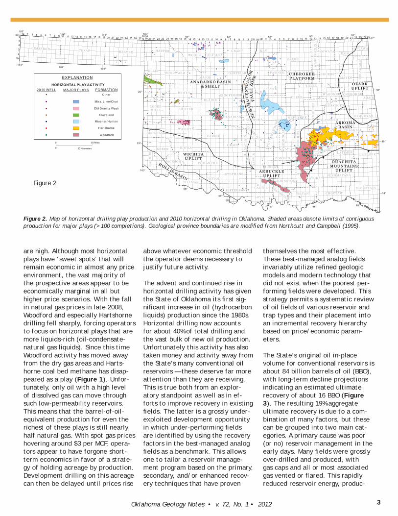
The State’s original oil in-place volume for conventional reservoirs is about 84 billion barrels of oil (BBO), with long-term decline projections indicating an estimated ultimate recovery of about 16 BBO (Figure 3). The resulting 19% aggregate ultimate recovery is due to a com-bination of many factors, but these can be grouped into two main cat-egories. A primary cause was poor (or no) reservoir management in the early days. Many fi elds were grossly over-drilled and produced, with gas caps and all or most associated gas vented or fl ared. This rapidly reduced reservoir energy, produc-
Oklahoma Geology Notes • v. 72, No. 1 • 20124
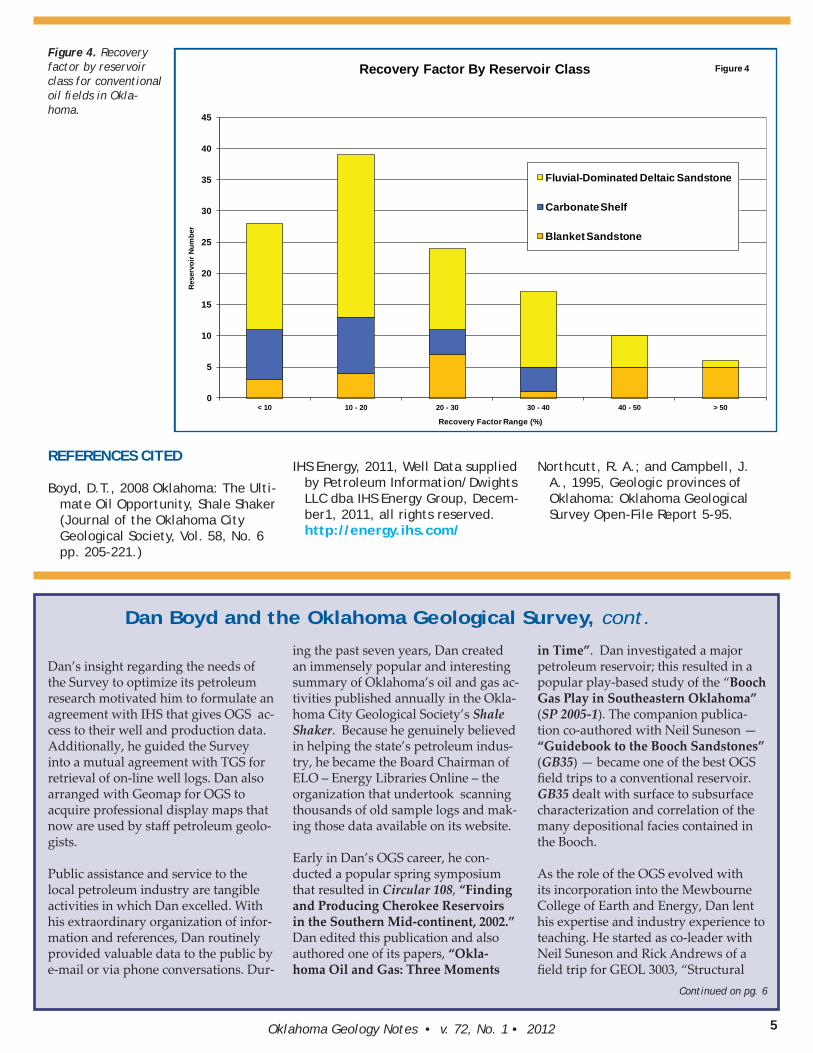
tion rates, and ultimate recovery. In addition, complex reservoir geome-tries, especially in the compartmen-talized channel-fi ll sandstones of the Fluvial-Dominated Deltaic reservoir class which predominate in the State, have left many parts of these fi elds poorly swept or undrained (Boyd, 2008).
The average ultimate recovery factors calculated for Oklahoma’s three major reservoir classes are as follows: Blanket Sandstone — 44%, Carbonate Shelf — 10%, and Fluvial-Dominated Deltaic Sandstone — 21% (Boyd, 2008). Each class has a wide range of recovery factors with many fi elds performing far below what would be expected given their average porosity and permeability. Although the factors that brought about low recovery factors will vary from fi eld to fi eld, certainly a large percentage in all three reservoir classes have signifi cant potential for improvement. The 123 fi elds that were used to generate these statis-tics are scattered throughout the State. If they are even remotely rep-resentative of the State as a whole, there are many opportunities — using simple (but modern) techniques — to
recover additional oil economically (Figure 4).
Based on recent mapping, the most attractive targets appear to be in fi elds producing from fl uvial reser-voirs, whose defi ning characteristic is their limited aerial extent and complex subsurface plumbing sys-tem. Although well-managed fi elds commonly have recovery factors in the 30% range, the median ultimate recovery factor for the fi elds in this class is only about 17% (Figure 3). As a class the channel-fi ll sandstone reservoirs in Oklahoma are the shal-lowest, representing between 2/3rds and 3/4ths of all conventional oil produced in the State, and account-ing for the largest share of the State’s oldest and most poorly man-aged fi elds. Even more important, they contain well over half the total oil that may be left in the ground at abandonment.
The incremental reserve additions that can be realized thorough a systematic reassessment of the State’s conventional oil fi elds is impossible to estimate reliably. How-ever, with a projected remaining oil in-place volume of 68 BBO, even
modest improvements to average recovery factors yield large volumes of incremental oil. For a conserva-tive case in which the average net improvements in recovery factor are 1% — 2% for each of the reservoir classes, which is signifi cantly below levels that are routinely achieved in the better-managed fi elds, the incremental volume of producible oil is still a staggering 1.4 BBO.
Horizontal drilling has dramati-cally increased reserves and holds promise in many areas of the State. However, it has also focused much of the industry into huge leasing expenditures that in turn are driv-ing large drilling programs designed to hold this acreage. In the current price environment many of these wells appear to be, at best, mar-ginally economic. Horizontal plays have their place, but their reliance on natural gas prices argues for a balanced exposure to conven-tional oil reservoirs. Given the oil produced already and the volume that is already mapped and still in the ground, a systematic program designed to improve the recovery in Oklahoma’s many under-performing fi elds is certainly justifi ed.
14.9
1.1
68.1
Oklahoma's Conventional Oil Endowment(In Billions of Barrels)
Oil Produced Through 2009
Incremental Oil Through ~2050
Remaining Oil In-Place
Estimated Original Oil In-Place 84.2 BBO
81% 18%
1%
Figure 3
Figure 3. Oklahoma’s Conventional Oil Endow-ment — Showing Oil Pro-duction and Remaining Oil Relative to Original Oil In-Place.
5Oklahoma Geology Notes • v. 72, No. 1 • 2012
Dan’s insight regarding the needs of the Survey to optimize its petroleum research motivated him to formulate an agreement with IHS that gives OGS ac-cess to their well and production data. Additionally, he guided the Survey into a mutual agreement with TGS for retrieval of on-line well logs. Dan also arranged with Geomap for OGS to acquire professional display maps that now are used by staff petroleum geolo-gists.
Public assistance and service to the local petroleum industry are tangible activities in which Dan excelled. With his extraordinary organization of infor-mation and references, Dan routinely provided valuable data to the public by e-mail or via phone conversations. Dur-
ing the past seven years, Dan created an immensely popular and interesting summary of Oklahoma’s oil and gas ac-tivities published annually in the Okla-homa City Geological Society’s Shale Shaker. Because he genuinely believed in helping the state’s petroleum indus-try, he became the Board Chairman of ELO – Energy Libraries Online – the organization that undertook scanning thousands of old sample logs and mak-ing those data available on its website.
Early in Dan’s OGS career, he con-ducted a popular spring symposium that resulted in Circular 108, “Finding and Producing Cherokee Reservoirs in the Southern Mid-continent, 2002.” Dan edited this publication and also authored one of its papers, “Okla-homa Oil and Gas: Three Moments
in Time”. Dan investigated a major petroleum reservoir; this resulted in a popular play-based study of the “Booch Gas Play in Southeastern Oklahoma” (SP 2005-1). The companion publica-tion co-authored with Neil Suneson — “Guidebook to the Booch Sandstones” (GB35) — became one of the best OGS fi eld trips to a conventional reservoir. GB35 dealt with surface to subsurface characterization and correlation of the many depositional facies contained in the Booch.
As the role of the OGS evolved with its incorporation into the Mewbourne College of Earth and Energy, Dan lent his expertise and industry experience to teaching. He started as co-leader with Neil Suneson and Rick Andrews of a fi eld trip for GEOL 3003, “Structural
0
5
10
15
20
25
30
35
40
45
< 10 10 - 20 20 - 30 30 - 40 40 - 50 > 50
Rese
rvoi
r Num
ber
Recovery Factor Range (%)
Recovery Factor By Reservoir Class
Fluvial-Dominated Deltaic Sandstone
Carbonate Shelf
Blanket Sandstone
Figure 4Figure 4. Recovery factor by reservoir class for conventional oil fi elds in Okla-homa.
REFERENCES CITED
Boyd, D.T., 2008 Oklahoma: The Ulti-mate Oil Opportunity, Shale Shaker (Journal of the Oklahoma City Geological Society, Vol. 58, No. 6 pp. 205-221.)
IHS Energy, 2011, Well Data supplied by Petroleum Information/Dwights LLC dba IHS Energy Group, Decem-ber1, 2011, all rights reserved. http://energy.ihs.com/
Northcutt, R. A.; and Campbell, J. A., 1995, Geologic provinces of Oklahoma: Oklahoma Geological Survey Open-File Report 5-95.
Dan Boyd and the Oklahoma Geological Survey, cont.
Continued on pg. 6
Oklahoma Geology Notes • v. 72, No. 1 • 20126
Geology and Stratigraphy for Petro-leum Engineers,” that viewed diff erent kinds of reservoir rocks in the Arkoma Basin and Arbuckle Mountains. This led to team-teaching a practical course in petroleum geology. The course, GEOL 4233, “Subsurface Methods,” is required of students seeking an undergraduate geology degree with a petroleum emphasis and has become increasingly popular during its four-year tenure.
An unrealized ambition of Dan’s was for the State to recognize that hard data is necessary for exploration and development of Oklahoma’s petroleum resources. Dan unceasingly tried to recover old data, particularly produc-tion data, and post it online for explo-rationists. He believed that we already know where most of Oklahoma’s oil is – the old, poorly produced oilfi elds – and that if we could apply modern reservoir analysis to those fi elds and had accurate production data, we could determine how much oil remained in the ground, ready for clever geologists and engineers to extract it.
We are happy that Dan is pursuing a long-standing dream of returning to the international petroleum arena with his departure to Doha, Qatar. Already, there are so many moments we miss and so many questions we would like to ask him. (Thank goodness for the internet, because we will!) We would like to express our gratitude for his unselfi sh contributions, his generous and highly valued professional opin-ions, and his unwavering dedication to the Survey. And on a personal note, we would like to thank him for all he taught us, and for his friendship.
Bibliography
1988. War-Wink South Field Study (Bone Spring – Wolfcamp) — Ward County, Texas. West Texas Geological Society Symposium Volume V, Oil and Gas Fields in West Texas.
2001. With Brian Cardott . Oklahoma’s Energy Landscape. OGS Information Series 9.
2002. Oklahoma Oil: Past, Present, and Future. Oklahoma Geology Notes.
2002. With Charlie Mankin and Bob Northcutt . Petroleum Developments in the Southern Mid-continent — An Overview. OGS Circular 107.
2002. Editor. Finding and Producing Cherokee Reservoirs in the Southern Mid-Continent, 2002 symposium. OGS Circular 108.
2002. Oklahoma Natural Gas: Past, Pres-ent, and Future. Oklahoma Geology Notes.
2002. Oklahoma Oil and Gas Fields (Distinguished by GOR and Con-ventional Gas vs. Coalbed Methane). 1:500,000-scale map and 128-page explanatory text. OGS GM-36.
2002. Oklahoma Oil and Gas Fields (Distinguished by Coalbed Methane and Field Boundaries). 1:500,000-scale map and 128-page explanatory text. OGS GM-37.
2002. Oklahoma Oil and Gas Fields (by Reservoir Age). 1:500,000-scale map. OGS GM-38.
2003. Oklahoma Oil and Natural Gas: Our Place in the Big Picture. Okla-homa Geology Notes.
2004. Oklahoma Oil, Natural Gas and Our Place in the Big Picture. OGS Information Series 10.
2004. Oklahoma Oil, Natural Gas and Our Place in the Big Picture. Shale Shaker.
2005. Oklahoma Oil and Gas Produc-tion: Its Components and Long-Term Outlook. Oklahoma Geology Notes.
2005. The Booch Gas Play in Southeast-ern Oklahoma: Regional and Field-Specifi c Petroleum Geological Analy-sis. Special Publication 2005-1.
2006. Oklahoma’s Oil and Gas Industry and the Global Forces Controlling It. Shale Shaker.
2006. Oil and Gas Production. Historical Atlas of Oklahoma (4th edition).
2007. Oklahoma 2006 Drilling Activity. Shale Shaker.
2007. With Rick Andrews and Neil Suneson. PE Students See Reservoirs in the Wild! Earth Scientist.
2007. With Neil Suneson. Sequence Stra-tigraphy and Depositional Environ-
ments of Booch Sandstones (McAl-ester Formation / Desmoinesian), Arkoma Basin, Oklahoma. AAPG Mid-Continent Section Meeting.
2008. Oklahoma 2007 Drilling High-lights. Shale Shaker. Oklahoma: The Ultimate Oil Opportunity. Shale Shaker. Reprinted in Oklahoma Geol-ogy Notes.
2008. Oil and Gas Production and Facili-ties of Oklahoma. OGS Educational Publication 9.
2008. With Neil Suneson. Guidebook to the Booch Sandstones: Surface to Subsurface Correlations. OGS Guide-book 35.
2009. Stratigraphic Guide to Oklahoma Oil and Gas Reservoirs. OGS Special Publication 2008-1.
2009. The Booch Gas Play in Southeast-ern Oklahoma: Regional and Field Specifi c Petroleum Geological Analy-sis. Oklahoma Geology Notes.
2009. With Neil Suneson. The OGS Booch Field Trip — Return to the Arkoma Basin. Oklahoma Geology Notes.
2009. Fighting the Tide: Morrow — Springer Gas in Oklahoma. OGS Circular 111.
2009. With Neil Suneson. The OGS Booch Field Trip – Return to the Ar-koma Basin. Earth Scientist.
2010. Oklahoma 2009 Drilling High-lights. Shale Shaker.
2011. Oklahoma 2010 Drilling High-lights. Shale Shaker.
2011. Electronic Oil and Gas Database Continues to Grow. Oklahoma Geol-ogy Notes.
2011. J. Glenn Cole: A Stratigraphic Legacy Preserved. Shale Shaker.
2011. Energy Libraries Online: An Up-date. Shale Shaker.
2011. With Rod Tillman, Nelson Osorio, and Russell Standridge. An Eastern Oklahoma Stratigraphic-Legacy Pre-served. AAPG Mid-Continent Section Meeting, Oklahoma City.
2012. Oklahoma 2011 Drilling High-lights. Shale Shaker.
Dan Boyd and the Oklahoma Geological Survey, cont.
7Oklahoma Geology Notes • v. 72, No. 1 • 2012 7777777777777777777777777777777777777777777777OkOOkOkOkOkOkOkOkOkOOkOOOOO lalalalalalalaaaaaalaahohohohohohohohooohooomammamammmammmaamamaama GGGGGGGGGGGGGGeoeoeoeoeooeooeeeooeoeoooeoooeooeololololooooooooooolololoooooooloolooloooolooooooloooloooooooooooggggggygygygygygygygygygygggyggygygggyggyggggggyggggggggggggyggggyggggggygggy NNNNNNNNNNNNNNNNNNNotototototoooootototototottototoooootototoootoooooootooto eseseseseesesesseseseesesesesssesessesesss ••••••••••••• vvvvvvvvvvvvvvvvvvvvvvvvvvvvvvvvvv................ 7272727272727272727272727272722727727272277272727272727272777272222777727727272777272777727227772,,,,,,,,,,,,,,,,,,,, NNNNNNoNNoNoNoNoNoNNoNoNoNoNoNNNNNNNoNoNNooNoooNooNoooNooNooooNoNNoooNoooooooNoo................... 11111111111111111111111111111111111111111111111111111 •••••••••••••• 2222222222222222222222222222222222222222222220000000010101010101101001010101001000100010100101010101111222222222222222222222222222
Suzanne Rogers, Sandstone Energy
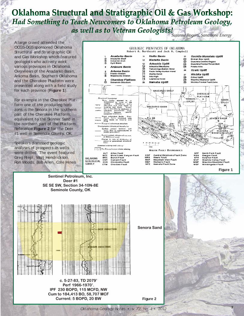
A large crowd attended the OCGS-OGS sponsored Oklahoma Structural and Stratigraphic Oil and Gas Workshop which featured geologists who actively work various provinces in Oklahoma. Overviews of the Anadarko Basin, Arkoma Basin, Southern Oklahoma and the Cherokee Platform were presented along with a fi eld study for each province (Figure 1).
For example in the Cherokee Plat-form one of the producing hori-zons is the Senora in the southern part of the Cherokee Platform, equivalent to the Skinner Sand in the northern part of the Platform. Reference Figure 2 for the Deer #1 well in Seminole County, OK.
Speakers discussed geologic analyses of prospects as wells were drilled. The event featured Greg Riepl, Walt Hendrickson, Ron Woods, Bob Allen, Cole Hines
Sentinel Petroleum, Inc.Deer #1
SE SE SW, Section 34-10N-8ESeminole County, OK
Senora Sand
c. 5-27-83, TD 2079’Perf 1966-1970’.
IPF 230 BOPD, 115 MCFD, NWCum to 184,413 BO, 58,707 MCF
Current: 5 BOPD, 20 BW Figure 2
Figure 1
Oklahoma Geology Notes • v. 72, No. 1 • 20128 OkOkOkOkOOkOkOOOOkOOOkOkOkO lalalallalaaalalaalaaaalaalaaaalahohohohohohohhhoohooohomamamammamaaaaaammmaaammmammaamamamama GGGGGGGGGGGGGGGGGGGGGeoeoeeoeoeoeoeoeoeoeooooeoooooeeeeoeoooeoeoeoeeeooeoeoeeoeooeoeeooeoeeeooeooeooooeeeoeeoooooeoeeeeoeooololololololoololololooloooloolololloologygygygygyggygygygyyyyyyygygyggygyyggygygyggyyygygyygygyyygygyyyyy NNNNNNNNNNNNNNNNNNNNNNNototototototototototototototototoottottttoototeseseseseseeeseeeseseseeseesesesessee •••••••••••••••••••••• vvvvvvvvvvvvvvvvvvvvvvvvvvvvvvvvvvvvvvvvvvvv............... 727272727272727272727272727272727272727272727272727277272727272772772727727227 ,,,,,,,,,,,,,,,, NoNoNoNoNoNoNoNoNoNoNoNoNoNoNoNoNoNNoNNoNoNoNoNoNNNoNoNNoNoNoNNoNoNoNoNoNoNoNoNoNooNoNoNooNoNoNooNooNNNoooNoNNN ........ 111111111111111111111111111111111111111111111111111111111111 •••••••••••••••••••••••••• 22222222222222222222222222222222222222222200000010100101010101010001010000101100101001010101001000000 222222222222222228888888888888888
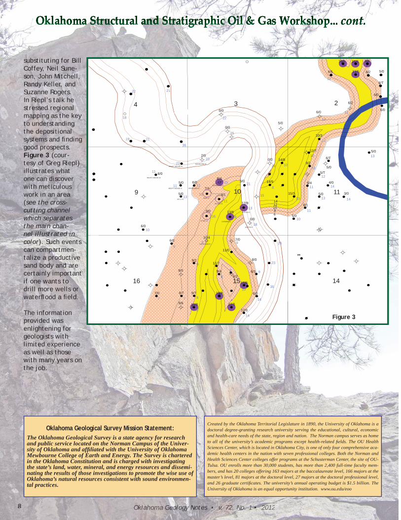
substituting for Bill Coffey, Neil Sune-son, John Mitchell, Randy Keller, and Suzanne Rogers. In Riepl’s talk he stressed regional mapping as the key to understanding the depositional systems and fi nding good prospects. Figure 3 (cour-tesy of Greg Riepl)illustrates what one can discover with meticulous work in an area (see the cross-cutting channel which separates the main chan-nel illustrated in color). Such events can compartmen-talize a productive sand body and are certainly important if one wants to drill more wells or waterfl ood a fi eld.
The information provided was enlightening for geologists with limited experience as well as those with many years on the job.
22
12
216/0
9/5
10/6 11/6
11/6 6/2
8/4
5/0
6/T
11
1222
25
18
234
10/3
5/0
6/2
6/0
0/0
0/0 6/0
36
2323
2119
10
10
10
11
13
26
25
11
McFARLAND #3MIGHTY MOUSE #3
2/014/8
12/T
6/T
5/T5/0
9/2
10/3
5/0
0/0
11
13
218
10
11
14
14
13
12
11
13
1011
11
1515
11
McFARLAND #1
McFARLAND #2
KELLY #1
MIGHTY MOUSE #1
MIGHTY MOUSE #2
119 106/0
5/0
8/43/0 14/9
6/1
3/0
4/0
5/0
5/T
6/4
15/3
5/0
6/0
12/9
8101214
SNYDER #1
HOPE #1
9/0
7/4
9/1
99
18
8 26
11
10
10
816
ALETHA #2
CAROTHERS #1
ALETHA #1
CLEMONS #1
6/010/4
0/05/0
6/0
13/8 68
7/0
EITHEL #1
9/0
9
23
35
7
9
8
8
8/0
1516 14
**
6/3
11/0
8/2
11/8
8/09/2
9/4
11/7
77
35
148
10
1488/T7/0
9/6
12/811/8
13/9
12/6
6/09/7
Figure 3
Created by the Oklahoma Territorial Legislature in 1890, the University of Oklahoma is a doctoral degree-granting research university serving the educational, cultural, economic and health-care needs of the state, region and nation. The Norman campus serves as home to all of the university’s academic programs except health-related fi elds. The OU Health Sciences Center, which is located in Oklahoma City, is one of only four comprehensive aca-demic health centers in the nation with seven professional colleges. Both the Norman and Health Sciences Center colleges offer programs at the Schusterman Center, the site of OU-Tulsa. OU enrolls more than 30,000 students, has more than 2,400 full-time faculty mem-bers, and has 20 colleges offering 163 majors at the baccalaureate level, 166 majors at the master’s level, 81 majors at the doctoral level, 27 majors at the doctoral professional level, and 26 graduate certifi cates. The university’s annual operating budget is $1.5 billion. The University of Oklahoma is an equal opportunity institution. www.ou.edu/eoo
Oklahoma Geological Survey Mission Statement:The Oklahoma Geological Survey is a state agency for research and public service located on the Norman Campus of the Univer-sity of Oklahoma and affi liated with the University of Oklahoma Mewbourne College of Earth and Energy. The Survey is chartered in the Oklahoma Constitution and is charged with investigating the state’s land, water, mineral, and energy resources and dissemi-nating the results of those investigations to promote the wise use of Oklahoma’s natural resources consistent with sound environmen-tal practices.
9Oklahoma Geology Notes • v. 72, No. 1 • 2012
Stanley T. Krukowski, Industrial Minerals Geologist
The 11th annual meeting of the Oklahoma Aggregates Association (OKAA) was held on January 24–25, 2012 at the Magnuson Hotel & Meridian Convention Center in Oklahoma City. The OKAA annual meeting provides an opportunity for its members to review, in an open forum, important issues that affect the aggregates industry. Aggregates industry profession-als including producers, plant superintendents, contractors, engineers, consultants, associate members, and interested govern-ment offi cials attend.
The 11th annual meeting was moderated by Chairman Randy Beeson with Executive Director Jim Rodriguez providing behind-the-scenes support and direction. Topics at the meeting this year in-cluded the Comprehensive State-wide Water Plan, management and regulation of wetlands dis-turbance and stream relocations, crushed stone use in reinforced concrete construction, and other issues. OGS Industrial Minerals Geologist Stan Krukowski spoke about sourcing aggregates today for society’s requirements. This year the meeting featured a panel discussion on land use planning highlighting cooperation of quarry operators, land owners, property developers, and city offi cials in the northeast Oklahoma cities of Tulsa and Owasso. Panel members were as follows:
1. Bob Ford and Tony Bauer— Bauer-Ford Reclamation Land-scape Architects and Planners, Inc. of Lansing, Michigan
2. Hank Harbaugh, Manager—Greenhill Properties, LLC, Tulsa, Oklahoma
3. David Charney—Owasso Land Trust, Owasso, Oklahoma
4. Rodney Ray, City Manager—City of Owasso, Oklahoma
5. John Curtis, President—Greenhill Materials Co., Inc., Catoosa, Oklahoma
The panel discussed how aban-doned aggregate mine lands can be successfully reclaimed and developed into residential and recreational properties. The project shows how diverse groups with apparent divergent inter-ests can come together to reach a common goal. And while these developments are occurring, the mine owner continues to mine the remaining resource, follow-ing a good-neighbor policy with all stakeholders. The mine-land reclamation project is a prime ex-ample of how sustainable devel-opment theory is put into practice with all parties benefi tting and in apparent agreement. Plans are in the making so that this project a stop for next year’s fi eld trip.Founded in 2001, the OKAA mis-sion statement declares that it provides “the medium through which the members may coordi-nate their efforts in discussing and resolving various problems
of common concern and interest within the State of Oklahoma. The Association speaks for all forums of aggregates, dimen-sion stone, construction mate-rial producers, and allied indus-tries in a unifi ed effort.”
The Oklahoma Geological Survey (OGS) has participated actively in the OKAA annual meeting since 2003. The OGS participa-tion also includes a booth in the OKAA annual meeting exhibition hall called the Market Place. In 2004 the OGS began coordinating and conducting annual meeting fi eld trips. Typically OKAA mem-bers showcase new operations or facilities at each fi eld trip stop. Examples include the Dolese Bros. Co. sand plant in Mustang, Okla-homa, along the Canadian River; the Martin Marietta Materials, Inc. North Troy quarry and the Texas Industries, Inc. Mill Creek crushed stone operation both near Mill Creek, Oklahoma; and the Boral Bricks Inc. brick plant north of Union City, Oklahoma.
Additionally mine service com-panies, OKAA affi liate members, participate by acting as hosts at fi eld trip stops at their facilities. In the past, OKAA fi eld trip stops have included Terex Corporation road-building equipment factory and training center in Oklahoma City; and this year Evans Enter-prises, Inc. laid down the red carpet for the OKAA visit.
Oklahoma Geological Survey Participates in the Oklahoma Aggregates Association
11th Annual Meeting and Field Trip
Oklahoma Geology Notes • v. 72, No. 1 • 201210
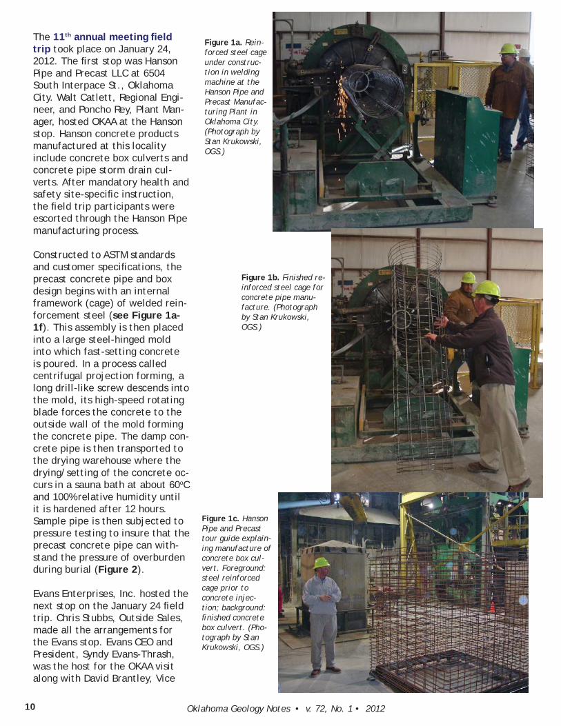
The 11th annual meeting fi eld trip took place on January 24, 2012. The fi rst stop was Hanson Pipe and Precast LLC at 6504 South Interpace St., Oklahoma City. Walt Catlett, Regional Engi-neer, and Poncho Rey, Plant Man-ager, hosted OKAA at the Hanson stop. Hanson concrete products manufactured at this locality include concrete box culverts and concrete pipe storm drain cul-verts. After mandatory health and safety site-specifi c instruction, the fi eld trip participants were escorted through the Hanson Pipe manufacturing process.
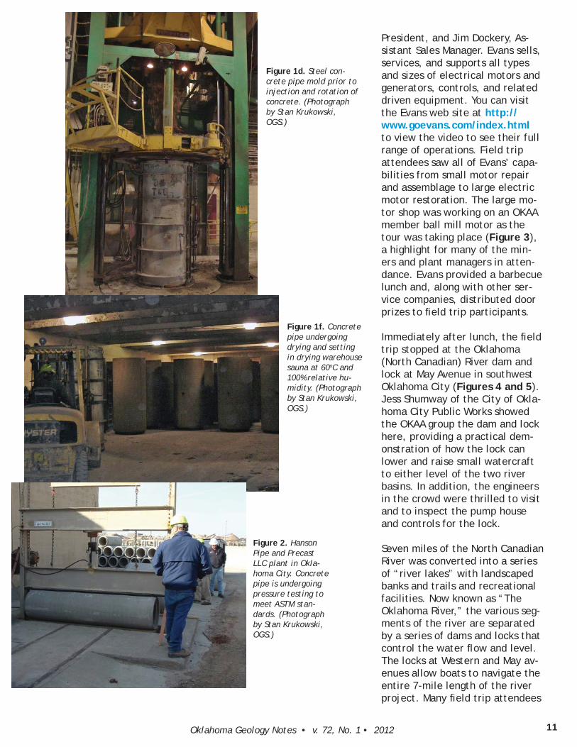
Constructed to ASTM standards and customer specifi cations, the precast concrete pipe and box design begins with an internal framework (cage) of welded rein-forcement steel (see Figure 1a-1f). This assembly is then placed into a large steel-hinged mold into which fast-setting concrete is poured. In a process called centrifugal projection forming, a long drill-like screw descends into the mold, its high-speed rotating blade forces the concrete to the outside wall of the mold forming the concrete pipe. The damp con-crete pipe is then transported to the drying warehouse where the drying/setting of the concrete oc-curs in a sauna bath at about 60oC and 100% relative humidity until it is hardened after 12 hours. Sample pipe is then subjected to pressure testing to insure that the precast concrete pipe can with-stand the pressure of overburden during burial (Figure 2).
Evans Enterprises, Inc. hosted the next stop on the January 24 fi eld trip. Chris Stubbs, Outside Sales, made all the arrangements for the Evans stop. Evans CEO and President, Syndy Evans-Thrash, was the host for the OKAA visit along with David Brantley, Vice
Figure 1a. Rein-forced steel cage under construc-tion in welding machine at the Hanson Pipe and Precast Manufac-turing Plant in Oklahoma City. (Photograph by Stan Krukowski, OGS.)
Figure 1b. Finished re-inforced steel cage for concrete pipe manu-facture. (Photograph by Stan Krukowski, OGS.)
Figure 1c. Hanson Pipe and Precast tour guide explain-ing manufacture of concrete box cul-vert. Foreground: steel reinforced cage prior to concrete injec-tion; background: fi nished concrete box culvert. (Pho-tograph by Stan Krukowski, OGS.)
11Oklahoma Geology Notes • v. 72, No. 1 • 2012
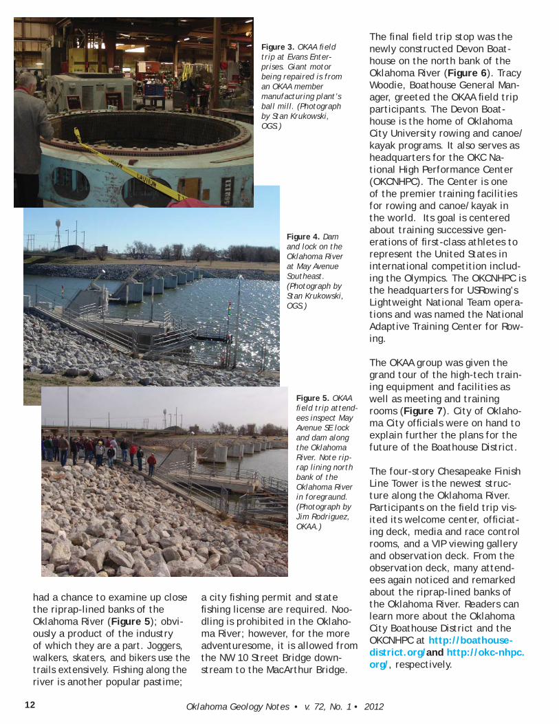
President, and Jim Dockery, As-sistant Sales Manager. Evans sells, services, and supports all types and sizes of electrical motors and generators, controls, and related driven equipment. You can visit the Evans web site at http://www.goevans.com/index.html to view the video to see their full range of operations. Field trip attendees saw all of Evans’ capa-bilities from small motor repair and assemblage to large electric motor restoration. The large mo-tor shop was working on an OKAA member ball mill motor as the tour was taking place (Figure 3), a highlight for many of the min-ers and plant managers in atten-dance. Evans provided a barbecue lunch and, along with other ser-vice companies, distributed door prizes to fi eld trip participants.
Immediately after lunch, the fi eld trip stopped at the Oklahoma (North Canadian) River dam and lock at May Avenue in southwest Oklahoma City (Figures 4 and 5). Jess Shumway of the City of Okla-homa City Public Works showed the OKAA group the dam and lock here, providing a practical dem-onstration of how the lock can lower and raise small watercraft to either level of the two river basins. In addition, the engineers in the crowd were thrilled to visit and to inspect the pump house and controls for the lock.
Seven miles of the North Canadian River was converted into a series of “river lakes” with landscaped banks and trails and recreational facilities. Now known as “The Oklahoma River,” the various seg-ments of the river are separated by a series of dams and locks that control the water fl ow and level. The locks at Western and May av-enues allow boats to navigate the entire 7-mile length of the river project. Many fi eld trip attendees
Figure 1d. Steel con-crete pipe mold prior to injection and rotation of concrete. (Photograph by Stan Krukowski, OGS.)
Figure 1f. Concrete pipe undergoing drying and setting in drying warehouse sauna at 60oC and 100% relative hu-midity. (Photograph by Stan Krukowski, OGS.)
Figure 2. Hanson Pipe and Precast LLC plant in Okla-homa City. Concrete pipe is undergoing pressure testing to meet ASTM stan-dards. (Photograph by Stan Krukowski, OGS.)
Oklahoma Geology Notes • v. 72, No. 1 • 201212
had a chance to examine up close the riprap-lined banks of the Oklahoma River (Figure 5); obvi-ously a product of the industry of which they are a part. Joggers, walkers, skaters, and bikers use the trails extensively. Fishing along the river is another popular pastime;
a city fi shing permit and state fi shing license are required. Noo-dling is prohibited in the Oklaho-ma River; however, for the more adventuresome, it is allowed from the NW 10 Street Bridge down-stream to the MacArthur Bridge.
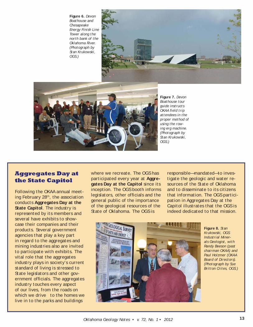
The fi nal fi eld trip stop was the newly constructed Devon Boat-house on the north bank of the Oklahoma River (Figure 6). Tracy Woodie, Boathouse General Man-ager, greeted the OKAA fi eld trip participants. The Devon Boat-house is the home of Oklahoma City University rowing and canoe/kayak programs. It also serves as headquarters for the OKC Na-tional High Performance Center (OKCNHPC). The Center is one of the premier training facilities for rowing and canoe/kayak in the world. Its goal is centered about training successive gen-erations of fi rst-class athletes to represent the United States in international competition includ-ing the Olympics. The OKCNHPC is the headquarters for USRowing’s Lightweight National Team opera-tions and was named the National Adaptive Training Center for Row-ing.
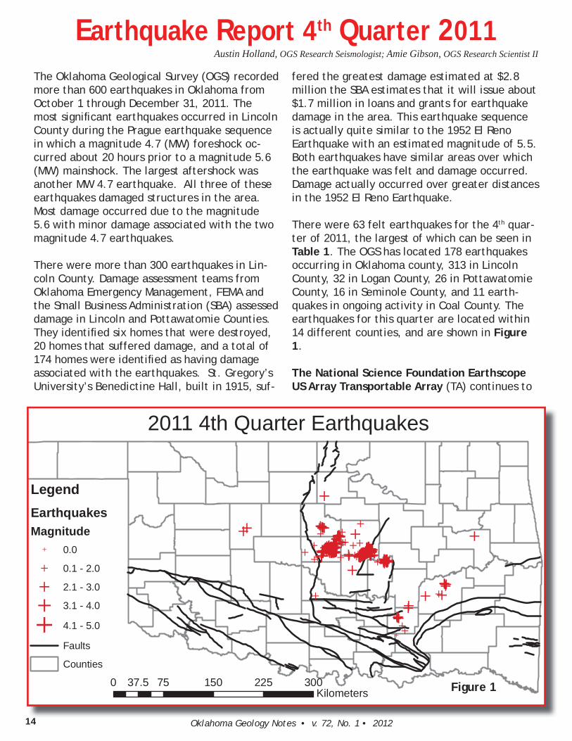
The OKAA group was given the grand tour of the high-tech train-ing equipment and facilities as well as meeting and training rooms (Figure 7). City of Oklaho-ma City offi cials were on hand to explain further the plans for the future of the Boathouse District.
The four-story Chesapeake Finish Line Tower is the newest struc-ture along the Oklahoma River. Participants on the fi eld trip vis-ited its welcome center, offi ciat-ing deck, media and race control rooms, and a VIP viewing gallery and observation deck. From the observation deck, many attend-ees again noticed and remarked about the riprap-lined banks of the Oklahoma River. Readers can learn more about the Oklahoma City Boathouse District and the OKCNHPC at http://boathouse-district.org/and http://okc-nhpc.org/, respectively.
Figure 3. OKAA fi eld trip at Evans Enter-prises. Giant motor being repaired is from an OKAA member manufacturing plant’s ball mill. (Photograph by Stan Krukowski, OGS.)
Figure 4. Dam and lock on the Oklahoma River at May Avenue Southeast. (Photograph by Stan Krukowski, OGS.)
Figure 5. OKAA fi eld trip attend-ees inspect May Avenue SE lock and dam along the Oklahoma River. Note rip-rap lining north bank of the Oklahoma River in foregraund. (Photograph by Jim Rodriguez, OKAA.)
13Oklahoma Geology Notes • v. 72, No. 1 • 2012
Figure 8. Stan Krukowski, OGS Industrial Miner-als Geologist, with Randy Beeson (past chairman OKAA) and Paul Holzmer (OKAA Board of Directors). (Photograph by Sue Britton Crites, OGS.)
Aggregates Day at the State Capitol
Following the OKAA annual meet-ing February 28th, the association conducts Aggregates Day at the State Capitol. The industry is represented by its members and several have exhibits to show-case their companies and their products. Several government agencies that play a key part in regard to the aggregates and mining industries also are invited to participate with exhibits. The vital role that the aggregates industry plays in society’s current standard of living is stressed to State legislators and other gov-ernment offi cials. The aggregates industry touches every aspect of our lives, from the roads on which we drive to the homes we live in to the parks and buildings
where we recreate. The OGS has participated every year at Aggre-gates Day at the Capitol since its inception. The OGS booth informs legislators, other offi cials and the general public of the importance of the geological resources of the State of Oklahoma. The OGS is
Figure 6. Devon Boathouse and Chesapeake Energy Finish Line Tower along the north bank of the Oklahoma River. (Photograph by Stan Krukowski, OGS.)
Figure 7. Devon Boathouse tour guide instructs OKAA fi eld trip attendees in the proper method of using the row-ing erg machine. (Photograph by Stan Krukowski, OGS.)
responsible—mandated—to inves-tigate the geologic and water re-sources of the State of Oklahoma and to disseminate to its citizens that information. The OGS partici-pation in Aggregates Day at the Capitol illustrates that the OGS is indeed dedicated to that mission.
Oklahoma Geology Notes • v. 72, No. 1 • 201214
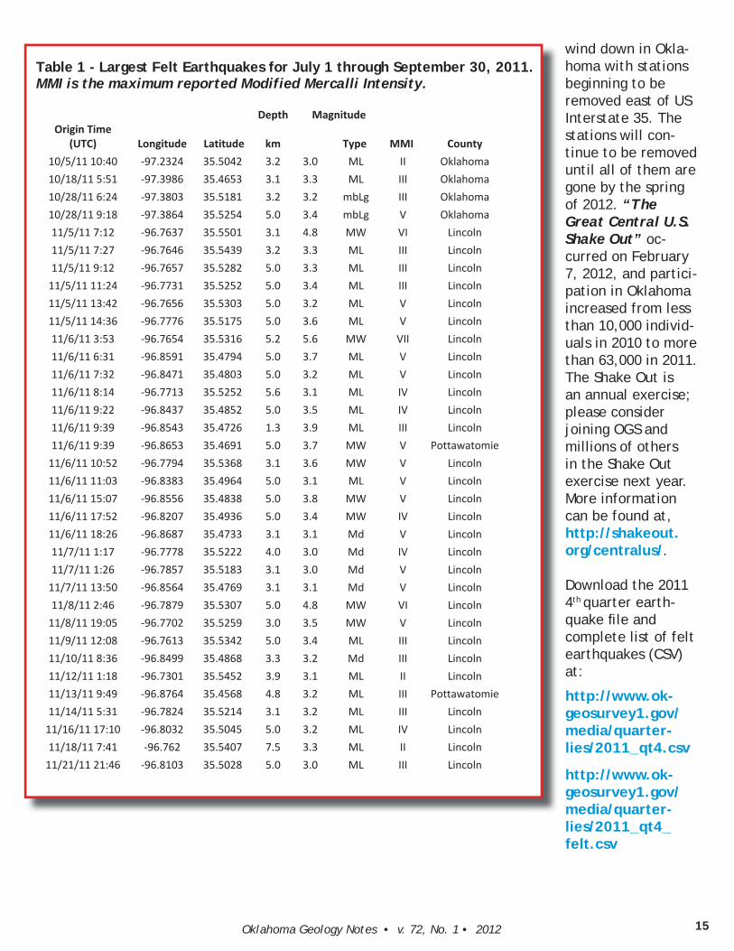
Earthquake Report 4th Quarter 2011The Oklahoma Geological Survey (OGS) recorded more than 600 earthquakes in Oklahoma from October 1 through December 31, 2011. The most signifi cant earthquakes occurred in Lincoln County during the Prague earthquake sequence in which a magnitude 4.7 (MW) foreshock oc-curred about 20 hours prior to a magnitude 5.6 (MW) mainshock. The largest aftershock was another MW 4.7 earthquake. All three of these earthquakes damaged structures in the area. Most damage occurred due to the magnitude 5.6 with minor damage associated with the two magnitude 4.7 earthquakes.
There were more than 300 earthquakes in Lin-coln County. Damage assessment teams from Oklahoma Emergency Management, FEMA and the Small Business Administration (SBA) assessed damage in Lincoln and Pottawatomie Counties. They identifi ed six homes that were destroyed, 20 homes that suffered damage, and a total of 174 homes were identifi ed as having damage associated with the earthquakes. St. Gregory’s University’s Benedictine Hall, built in 1915, suf-
fered the greatest damage estimated at $2.8 million the SBA estimates that it will issue about $1.7 million in loans and grants for earthquake damage in the area. This earthquake sequence is actually quite similar to the 1952 El Reno Earthquake with an estimated magnitude of 5.5. Both earthquakes have similar areas over which the earthquake was felt and damage occurred. Damage actually occurred over greater distances in the 1952 El Reno Earthquake.
There were 63 felt earthquakes for the 4th quar-ter of 2011, the largest of which can be seen in Table 1. The OGS has located 178 earthquakes occurring in Oklahoma county, 313 in Lincoln County, 32 in Logan County, 26 in Pottawatomie County, 16 in Seminole County, and 11 earth-quakes in ongoing activity in Coal County. The earthquakes for this quarter are located within 14 different counties, and are shown in Figure 1.
The National Science Foundation Earthscope US Array Transportable Array (TA) continues to
14
ÍÍÍÍÍÍÍÍÍÍÍÍÍÍÍÍÍÍÍÍ
ÍÍÍÍÍÍ
ÍÍÍ
ÍÍ
ÍÍÍÍ ÍÍÍÍÍÍÍÍÍÍ
ÍÍÍÍÍÍ
Í
Í
ÍÍ
ÍÍÍÍÍ
ÍÍ
Í
Í
Í
Í
Í
Í
ÍÍ
ÍÍÍ
Í
ÍÍÍÍÍ
ÍÍÍ
ÍÍ
Í
ÍÍÍÍÍ
Í
Í
Í
ÍÍÍ
Í
ÍÍÍÍÍ
ÍÍÍÍÍÍÍ
Í
Í
Í
Í
ÍÍÍÍ
Í
Í
ÍÍÍÍÍÍÍÍÍÍÍÍ
ÍÍ
ÍÍÍÍÍÍÍ
Í
ÍÍ
Í
Í
ÍÍÍ
ÍÍ
Í
ÍÍÍÍ
ÍÍÍÍÍÍÍÍÍÍÍÍÍÍÍÍÍÍÍÍÍÍÍÍÍÍÍÍÍÍÍÍÍÍÍÍÍÍÍÍÍÍÍÍÍÍÍÍÍÍÍÍÍÍÍÍÍÍÍÍÍÍÍÍÍÍÍÍÍÍÍÍÍÍÍÍÍÍÍÍÍÍÍÍ
ÍÍÍÍÍÍÍÍÍÍÍÍÍÍÍÍÍÍ
ÍÍÍÍÍÍÍÍÍÍÍÍÍÍÍÍÍÍÍÍÍÍÍÍÍÍÍÍÍÍÍÍÍÍÍ ÍÍÍÍÍÍÍÍÍÍÍÍÍÍÍÍ ÍÍÍÍÍÍÍÍÍÍÍÍÍÍÍÍÍÍÍÍÍÍÍÍÍÍÍÍÍÍÍÍÍ
Í
ÍÍÍ
Í
ÍÍÍÍÍÍÍ
ÍÍÍÍ
Í
ÍÍÍÍ
ÍÍ
Í
ÍÍÍÍÍÍÍÍÍÍÍÍÍÍÍ
ÍÍÍÍÍÍÍ
ÍÍÍ
ÍÍ ÍÍÍÍÍ ÍÍÍÍÍÍ
ÍÍÍÍÍÍÍÍÍÍÍ
ÍÍ
Í
ÍÍ
ÍÍÍÍÍ
Í
ÍÍÍÍ ÍÍÍÍÍ ÍÍÍ
ÍÍ
ÍÍÍÍÍÍÍÍÍÍ
ÍÍÍ
ÍÍ
Í
Í Í
ÍÍÍ
ÍÍÍÍÍÍÍ
ÍÍ
ÍÍ
ÍÍ
Í
ÍÍÍ Í ÍÍÍ
ÍÍÍÍÍÍ
ÍÍÍ
ÍÍÍ
Í
ÍÍ
Í
Í
Í
Í
ÍÍ
ÍÍ
Í ÍÍÍÍÍ
ÍÍ
Í
ÍÍÍÍÍÍÍÍÍ
Í
ÍÍÍÍ ÍÍÍ ÍÍÍÍÍÍÍ ÍÍÍÍÍÍ ÍÍÍÍÍÍÍ ÍÍÍ
Í
ÍÍÍÍÍÍ ÍÍ
Í Í
Í
ÍÍÍÍ Í
Í ÍÍÍÍÍÍÍÍÍÍÍ
Í
ÍÍÍ
Í
ÍÍ
Í
Í
ÍÍÍ
Í Í
ÍÍ
2011 4th Quarter Earthquakes
0 75 150 225 30037.5Kilometers
LegendEarthquakesMagnitude
Í 0.0
Í 0.1 - 2.0
Í 2.1 - 3.0
Í 3.1 - 4.0
Í 4.1 - 5.0
Faults
Counties
Figure 1
Austin Holland, OGS Research Seismologist; Amie Gibson, OGS Research Scientist II
15Oklahoma Geology Notes • v. 72, No. 1 • 2012
wind down in Okla-homa with stations beginning to be removed east of US Interstate 35. The stations will con-tinue to be removed until all of them are gone by the spring of 2012. “The Great Central U.S. Shake Out” oc-curred on February 7, 2012, and partici-pation in Oklahoma increased from less than 10,000 individ-uals in 2010 to more than 63,000 in 2011. The Shake Out is an annual exercise; please consider joining OGS and millions of others in the Shake Out exercise next year. More information can be found at, http://shakeout.org/centralus/.
Download the 2011 4th quarter earth-quake fi le and complete list of felt earthquakes (CSV) at:
http://www.ok-geosurvey1.gov/media/quarter-lies/2011_qt4.csv
http://www.ok-geosurvey1.gov/media/quarter-lies/2011_qt4_felt.csv
Table 1 - Largest Felt Earthquakes for July 1 through September 30, 2011. MMI is the maximum reported Modified Mercalli Intensity.
Depth MagnitudeOrigin Time
(UTC) Longitude Latitude km Type MMI County10/5/11 10:40 97.2324 35.5042 3.2 3.0 ML II Oklahoma10/18/11 5:51 97.3986 35.4653 3.1 3.3 ML III Oklahoma10/28/11 6:24 97.3803 35.5181 3.2 3.2 mbLg III Oklahoma10/28/11 9:18 97.3864 35.5254 5.0 3.4 mbLg V Oklahoma11/5/11 7:12 96.7637 35.5501 3.1 4.8 MW VI Lincoln11/5/11 7:27 96.7646 35.5439 3.2 3.3 ML III Lincoln11/5/11 9:12 96.7657 35.5282 5.0 3.3 ML III Lincoln11/5/11 11:24 96.7731 35.5252 5.0 3.4 ML III Lincoln11/5/11 13:42 96.7656 35.5303 5.0 3.2 ML V Lincoln11/5/11 14:36 96.7776 35.5175 5.0 3.6 ML V Lincoln11/6/11 3:53 96.7654 35.5316 5.2 5.6 MW VII Lincoln11/6/11 6:31 96.8591 35.4794 5.0 3.7 ML V Lincoln11/6/11 7:32 96.8471 35.4803 5.0 3.2 ML V Lincoln11/6/11 8:14 96.7713 35.5252 5.6 3.1 ML IV Lincoln11/6/11 9:22 96.8437 35.4852 5.0 3.5 ML IV Lincoln11/6/11 9:39 96.8543 35.4726 1.3 3.9 ML III Lincoln11/6/11 9:39 96.8653 35.4691 5.0 3.7 MW V Pottawatomie11/6/11 10:52 96.7794 35.5368 3.1 3.6 MW V Lincoln11/6/11 11:03 96.8383 35.4964 5.0 3.1 ML V Lincoln11/6/11 15:07 96.8556 35.4838 5.0 3.8 MW V Lincoln11/6/11 17:52 96.8207 35.4936 5.0 3.4 MW IV Lincoln11/6/11 18:26 96.8687 35.4733 3.1 3.1 Md V Lincoln11/7/11 1:17 96.7778 35.5222 4.0 3.0 Md IV Lincoln11/7/11 1:26 96.7857 35.5183 3.1 3.0 Md V Lincoln11/7/11 13:50 96.8564 35.4769 3.1 3.1 Md V Lincoln11/8/11 2:46 96.7879 35.5307 5.0 4.8 MW VI Lincoln11/8/11 19:05 96.7702 35.5259 3.0 3.5 MW V Lincoln11/9/11 12:08 96.7613 35.5342 5.0 3.4 ML III Lincoln11/10/11 8:36 96.8499 35.4868 3.3 3.2 Md III Lincoln11/12/11 1:18 96.7301 35.5452 3.9 3.1 ML II Lincoln11/13/11 9:49 96.8764 35.4568 4.8 3.2 ML III Pottawatomie11/14/11 5:31 96.7824 35.5214 3.1 3.2 ML III Lincoln11/16/11 17:10 96.8032 35.5045 5.0 3.2 ML IV Lincoln11/18/11 7:41 96.762 35.5407 7.5 3.3 ML II Lincoln11/21/11 21:46 96.8103 35.5028 5.0 3.0 ML III Lincoln
Oklahoma Geological SurveyTHE UNIVERSITY OF OKLAHOMAMEWBOURNE COLLEGE OF EARTH & ENERGY100 E. Boyd, Room N-131Norman, Oklahoma 73019-0628
A State Agency Serving the People of Oklahoma
Non-Profit OrganizationU.S.Postage
PAIDUniversity of Oklahoma
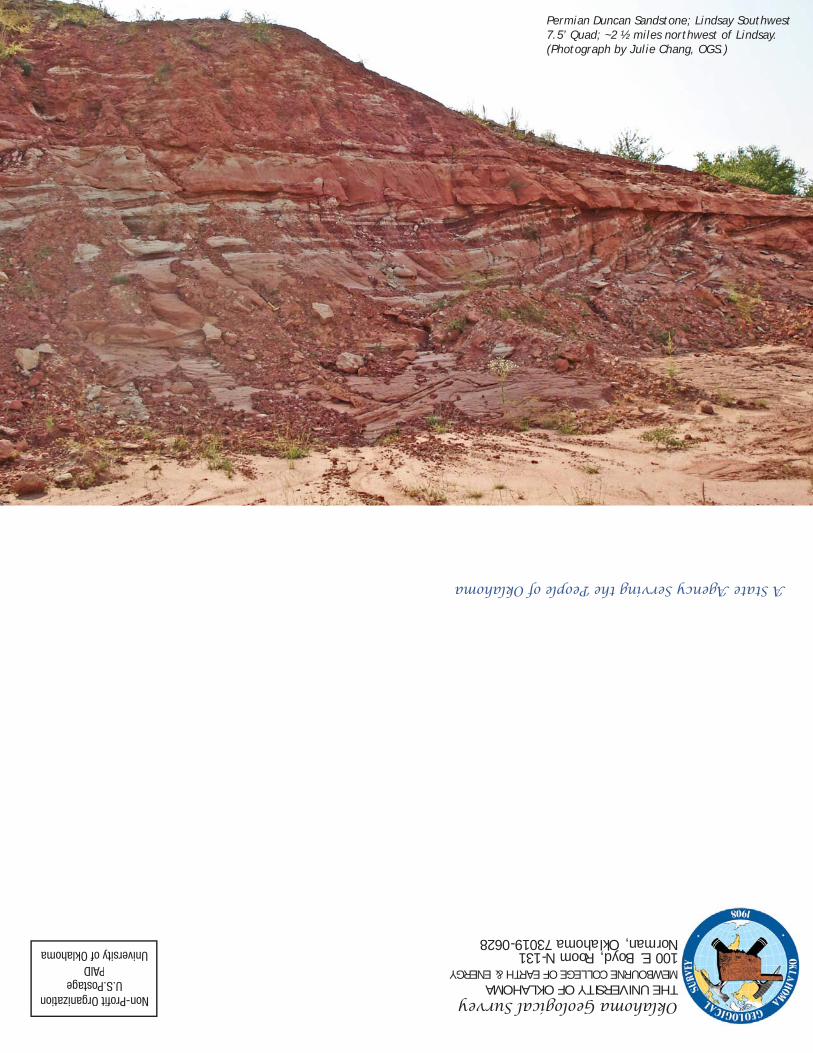
Permian Duncan Sandstone; Lindsay Southwest 7.5’ Quad; ~2 ½ miles northwest of Lindsay. (Photograph by Julie Chang, OGS.)