Embed Size (px)
Citation preview

“This project has received funding from
the European Union’s Horizon 2020
research and innovation programme
under grant agreement No 636329”.
D6.3 Service for reporting VTS information and forwarding and sharing information between VTS centres
Project no. 636329
Project acronym: EfficienSea2
EFFICIENSEA2 – efficient, safe and sustainable traffic at sea
Funding scheme: Innovation Action (IA)
Start date of project: 1 May 2015
End date of project: 30 April 2018
Duration: 36 months
Due date of deliverable: 31.10.2017
Actual submission date: 15.12.2017
Organisation in
charge of deliverable: Swedish Maritime Administration
Page 2 of 27 “This project has received funding from
the European Union’s Horizon 2020
research and innovation programme under
grant agreement No 636329”.
açÅìãÉåí=pí~íìë=
^ìíÜçêë=
Name Organisation
Richard Nilsson Swedish Maritime Administration
Fredrik Kokacka Swedish Maritime Administration
Cajsa Jersler Fransson Swedish Maritime Administration
Roland Beeres Danish Maritime Authority
açÅìãÉåí=eáëíçêó=
Version Date Initials Description
0.2 2017-10-19 RN Added first draft into correct format in template.
0.3 2017-10-25 RN/FK Minor additions
0.4 2017-11-07 RN/FK Added more descriptive texts
0.5 2017-11-13 RN Added use cases
0.6 2017-11-13 CJF/RB Amended some parts and wrote about Baltic Web
etc.
0.7 2017-11-22 RN Formatting and some additions
0.8 2017-11-26 RN Proper format, finalizing for review
1.0 2017-12-15 RN/CJF Review finished, last version
oÉîáÉï=
Name Organisation
Mikko Klang FTA
Tuomas Martikainen FTA
Björnar Aas Vissim
Max Semenov Vissim
Marco Svantesson SMA (VTS Sound)
Page 3 of 27 “This project has received funding from
the European Union’s Horizon 2020
research and innovation programme under
grant agreement No 636329”.
Contents Document Status ..................................................................................................................... 2
Authors ................................................................................................................................. 2
Document History ................................................................................................................. 2
Review ................................................................................................................................. 2
1 Introduction ....................................................................................................................... 4
2 How information gets to BSR VTS centres today ............................................................. 4
2.1 VTS Designators ......................................................................................................... 5
2.2 How reporting is conducted to SOUNDREP today ..................................................... 5
2.3 How reporting is conducted to GOFREP today .......................................................... 7
2.4 Comparison between requested information .............................................................. 9
3 Sharing of information between VTS centres in the BSR ............................................... 11
4 How to improve the flow of information? ......................................................................... 11
5 The information flow path with the means available today .............................................. 12
5.1 Reporting at Sound VTS ........................................................................................... 13
5.2 Reporting at Helsinki Traffic ...................................................................................... 13
5.3 ENSI ......................................................................................................................... 13
5.4 AIS ............................................................................................................................ 14
6 VISSIM and other 3rd party suppliers .............................................................................. 14
6.1 Standalone laptops with VISSIM / ENSI ................................................................... 14
6.1.1 Integration VISSIM, ENSI and AIS ..................................................................... 14
7 Use cases standalone laptop .......................................................................................... 15
7.1 Voyage Oulu, FI – Gothenburg, SE .......................................................................... 15
7.2 Voyage Helsinki, FI – Amsterdam, NL ...................................................................... 18
8 Baltic Web ...................................................................................................................... 19
8.1 SRS-reporting in Baltic Web ..................................................................................... 19
9 Summary ........................................................................................................................ 24
10 List of Acronyms ............................................................................................................. 25
11 Reference list .................................................................................................................. 26
Page 4 of 27 “This project has received funding from
the European Union’s Horizon 2020
research and innovation programme under
grant agreement No 636329”.
N fåíêçÇìÅíáçå=This report aims to describe and explain how Vessel Traffic Service (VTS) information is
reported today in the Baltic Sea Region (BSR) and demonstrate different ways of how to
improve and streamline how reporting is being conducted.
The overall goal of improving and streamlining the way reporting is being conducted today is
to reduce administrative burdens for all involved parties, both the parties supplying information
and the parties receiving information.
To demonstrate a possible solution for how to move forward, a software, Vissim VTMS3000
(Vessel Traffic Management System) Traffic Display, has been installed onto two standalone
laptops by VISSIM technicians. The VTMS3000 Traffic Display has been integrated with the
Finnish Enhanced Navigation Support Information-system (ENSI) to be able to receive both
ship reports and route reports from ships that are uploading this information to ENSI.
One of the laptops has been provided to a Vessel Traffic Service Operator (VTSO) at Sound
VTS for testing purposes and has been be used to create the use cases being described in
this report.
The other laptop has been delivered to Tallinn VTS for evaluation purposes.
There are also other options of how to improve current means of reporting and such examples
will also be covered by this report.
Three of the authors of this report work at the Swedish Maritime Administration (SMA) and are
currently, or have previously been, working at, or in close relation to Sound VTS. The fourth
author works at the Danish Maritime Administration (DMA) with development of the Baltic Web
(BW) platform.
O eçï=áåÑçêã~íáçå=ÖÉíë=íç=_po=sqp=ÅÉåíêÉë=íçÇ~ó=When a ship transits the BSR today the Officer on watch (OOW) on board has to send
multiple reports to multiple different recipients such as Ship Reporting Systems (SRS’s),
VTS’s, Ports, and Authorities etc. The way that the reports are filled in and submitted differs
from recipient to recipient and is not harmonized. The requested information also varies and
depends upon which entity is requesting a report from the ship. There is virtually no report
exchange being conducted across the different recipients.
Page 5 of 27 “This project has received funding from
the European Union’s Horizon 2020
research and innovation programme under
grant agreement No 636329”.
OKN sqp=aÉëáÖå~íçêë=All possible designators that the OOW of the vessel might be requested to supply to VTS
centres before entering a VTS area are stated in IMO RESOLUTION A.851(20), GENERAL
PRINCIPLES FOR SHIP REPORTING SYSTEMS AND SHIP REPORTING
REQUIREMENTS, INCLUDING GUIDELINES FOR REPORTING INCIDENTS INVOLVING
DANGEROUS GOODS, HARMFUL SUBSTANCES AND/OR MARINE POLLUTANTS.
These designators are also listed below in Chapter 2.4 which compares the requested
information by VTS’s in BSR.
OKO eçï=êÉéçêíáåÖ=áë=ÅçåÇìÅíÉÇ=íç=plrkaobm=íçÇ~ó=“Participation in the SOUNDREP Ship Reporting System is mandatory for all vessels above
300 GT transiting through the SOUNDREP operational area or proceeding to or from ports
and anchorages in The Sound.
Vessels can fulfil most of the reporting procedures by using non-verbal means such as an e-
mail report or the online reporting form prior to entering. However, vessels must anyway
establish contact on VHF when entering the area.
The following categories of vessels are exempt from the Reporting System, but are
encouraged to participate: Warships, Naval Auxiliaries or Vessels owned by a contracting
government and used only in government non-commercial service." (Sjofartsverket.se, 2017)
As you can tell there are 3 possible ways of reporting required information to Sound VTS.
The options available for ships of more than 300 GRT passing through the Sound are by
traditional Very High Frequency (VHF) Radio, sending an e-mail to Sound VTS with the
required information or using the Online Reporting Form.
The Online Reporting Form which is currently in use at Sound VTS was developed within the
EfficienSea2 project and is described in Deliverable 6.4. The Online Reporting Form is easily
found by visiting the website of Sound VTS.
Based on experience from Sound VTS most vessels passing through the Sound are reporting
electronically, either via e-mail or using the Online Reporting Form.
Vessels passing through for the first time or very seldom, tend to report in the traditional way
- using VHF Radio.
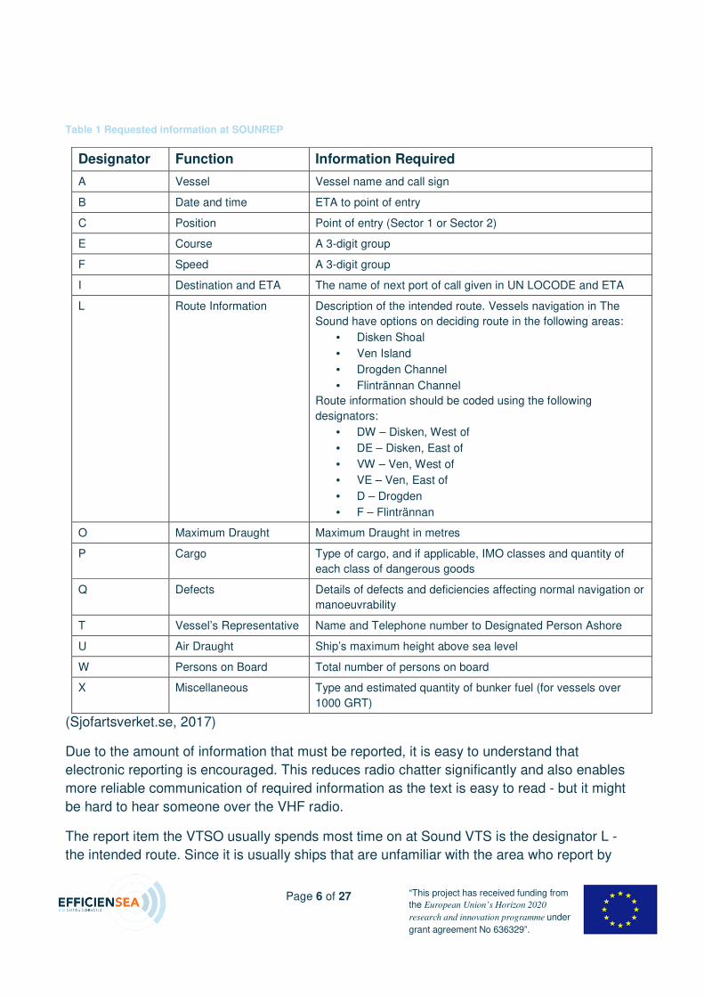
The requested information is as follows:
Page 6 of 27 “This project has received funding from
the European Union’s Horizon 2020
research and innovation programme under
grant agreement No 636329”.
Table 1 Requested information at SOUNREP
Designator Function Information Required
A Vessel Vessel name and call sign
B Date and time ETA to point of entry
C Position Point of entry (Sector 1 or Sector 2)
E Course A 3-digit group
F Speed A 3-digit group
I Destination and ETA The name of next port of call given in UN LOCODE and ETA
L Route Information Description of the intended route. Vessels navigation in The
Sound have options on deciding route in the following areas:
• Disken Shoal
• Ven Island
• Drogden Channel
• Flintrännan Channel
Route information should be coded using the following
designators:
• DW – Disken, West of
• DE – Disken, East of
• VW – Ven, West of
• VE – Ven, East of
• D – Drogden
• F – Flintrännan
O Maximum Draught Maximum Draught in metres
P Cargo Type of cargo, and if applicable, IMO classes and quantity of
each class of dangerous goods
Q Defects Details of defects and deficiencies affecting normal navigation or
manoeuvrability
T Vessel’s Representative Name and Telephone number to Designated Person Ashore
U Air Draught Ship’s maximum height above sea level
W Persons on Board Total number of persons on board
X Miscellaneous Type and estimated quantity of bunker fuel (for vessels over
1000 GRT)
(Sjofartsverket.se, 2017)
Due to the amount of information that must be reported, it is easy to understand that
electronic reporting is encouraged. This reduces radio chatter significantly and also enables
more reliable communication of required information as the text is easy to read - but it might
be hard to hear someone over the VHF radio.
The report item the VTSO usually spends most time on at Sound VTS is the designator L -
the intended route. Since it is usually ships that are unfamiliar with the area who report by
Page 7 of 27 “This project has received funding from
the European Union’s Horizon 2020
research and innovation programme under
grant agreement No 636329”.
VHF radio – and in addition, these are the ships that are most likely to not be accustomed to
the various names in the Sound and the various route options, this report item can often be
challenging.
By having this information supplied electronically, the administrative burden is reduced
significantly for both the OOW and the VTSO.
OKP eçï=êÉéçêíáåÖ=áë=ÅçåÇìÅíÉÇ=íç=dlcobm=íçÇ~ó=
"GOFREP [(Gulf of Finland Ship Reporting System)] is a Mandatory Ship Reporting
System[.][...] The sea areas in the Gulf of Finland are monitored jointly by Finland, Estonia
and the Russian Federation. The Traffic Centres monitor shipping by use of radar and AIS
[(Automatic Identification System]) and provide 24 h information service in the Gulf of
Finland.
[…] Ships of 300 gross tonnage and over are required to participate in the mandatory ship
reporting system.
[…] Ships are encouraged to give their Full Report in advance by nonverbal means (e-mail or
telefax).
Information can also be given by verbal means (VHF) when entering the traffic area."
(GOFREP Master's Guide, 2010)`
Currently there is also another reporting option available for ships transiting GOFREP; the
ENSI service.
"With the help of the ENSI service […] that has been taken into test use, accurate route plans
can be prepared for the use of maritime traffic control and information in electronic format is
provided to vessels in order to help navigation. This will improve the safety of maritime traffic
and reduce risks of oil accidents." (Liikennevirasto.fi, 2017)
"ENSI is an e-navigation test bed that takes navigational communication to the next level,
utilizing technical equipment already on-board. The only additional element needed is a
modern way of thinking; information sharing with correct methods, leading to less surprises
and higher efficiency. And it's free." (Extranet.liikennevirasto.fi, 2017)
To communicate ship information through ENSI a free-of-charge stand-alone client needs to
be installed in an already existing onboard computer, unless the ship’s Electronic Chart
Display and Information System (ECDIS)-manufacturer has implemented ENSI-connectivity.
The stand-alone client is useful even in environments where you cannot guarantee constant
internet-connections.
Page 8 of 27 “This project has received funding from
the European Union’s Horizon 2020
research and innovation programme under
grant agreement No 636329”.
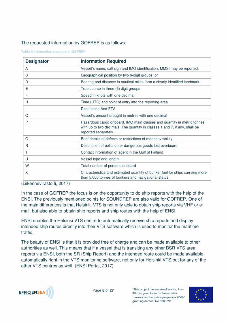
The requested information by GOFREP is as follows:
Table 2 Information required at GOFREP
Designator Information Required
A Vessel’s name, call sign and IMO identification, MMSI may be reported.
B Geographical position by two 6-digit groups; or
D Bearing and distance in nautical miles form a clearly identified landmark
E True course in three (3) digit groups
F Speed in knots with one decimal
H Time (UTC) and point of entry into the reporting area
I Destination And ETA
O Vessel’s present draught in metres with one decimal
P Hazardous cargo onboard, IMO main classes and quantity in metric tonnes
with up to two decimals. The quantity in classes 1 and 7, if any, shall be
reported separately.
Q Brief details of defects or restrictions of manoeuvrability
R Description of pollution or dangerous goods lost overboard
T Contact information of agent in the Gulf of Finland
U Vessel type and length
W Total number of persons onboard
X Characteristics and estimated quantity of bunker fuel for ships carrying more
than 5,000 tonnes of bunkers and navigational status.
(Liikennevirasto.fi, 2017)
In the case of GOFREP the focus is on the opportunity to do ship reports with the help of the
ENSI. The previously mentioned points for SOUNDREP are also valid for GOFREP. One of
the main differences is that Helsinki VTS is not only able to obtain ship reports via VHF or e-
mail, but also able to obtain ship reports and ship routes with the help of ENSI.
ENSI enables the Helsinki VTS centre to automatically receive ship reports and display
intended ship routes directly into their VTS software which is used to monitor the maritime
traffic.
The beauty of ENSI is that it is provided free of charge and can be made available to other
authorities as well. This means that if a vessel that is transiting any other BSR VTS area
reports via ENSI, both the SR (Ship Report) and the intended route could be made available
automatically right in the VTS monitoring software, not only for Helsinki VTS but for any of the
other VTS centres as well. (ENSI Portal, 2017)
Page 9 of 27 “This project has received funding from
the European Union’s Horizon 2020
research and innovation programme under
grant agreement No 636329”.
By having the required information provided in this way together with the possibility of
updating single information points such as the ship's draught along the way the administrative
burden could be further decreased both for OOW and VTSO.
The overall goal is of course to have this information read automatically by the ship's
equipment to the extent that this is possible, and then when all required information for the
ship report is put together, the ship report and intended route can be sent directly from the
ship's onboard ECDIS (or similar equipment) to the relevant authorities.
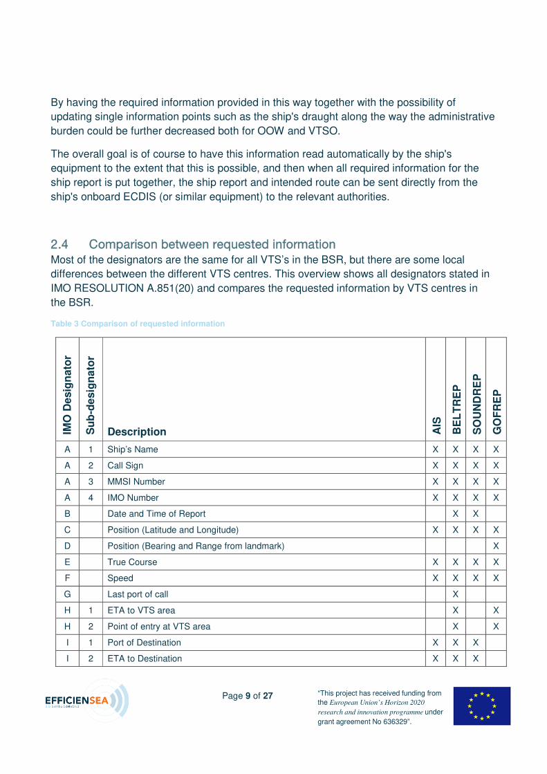
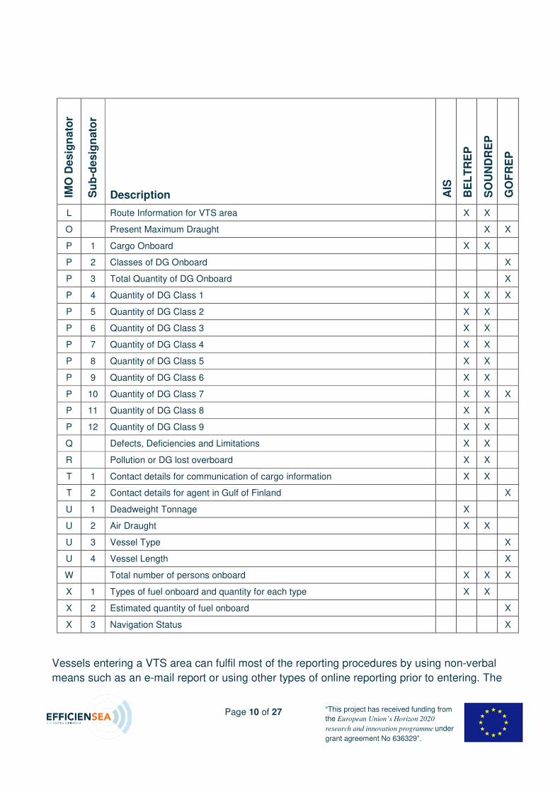
OKQ `çãé~êáëçå=ÄÉíïÉÉå=êÉèìÉëíÉÇ=áåÑçêã~íáçå=
Most of the designators are the same for all VTS’s in the BSR, but there are some local
differences between the different VTS centres. This overview shows all designators stated in
IMO RESOLUTION A.851(20) and compares the requested information by VTS centres in
the BSR.
Table 3 Comparison of requested information
IMO
Desig
nato
r
Su
b-d
esig
nato
r
Description AIS
BE
LT
RE
P
SO
UN
DR
EP
GO
FR
EP
A 1 Ship’s Name X X X X
A 2 Call Sign X X X X
A 3 MMSI Number X X X X
A 4 IMO Number X X X X
B Date and Time of Report X X
C Position (Latitude and Longitude) X X X X
D Position (Bearing and Range from landmark) X
E True Course X X X X
F Speed X X X X
G Last port of call X
H 1 ETA to VTS area X X
H 2 Point of entry at VTS area X X
I 1 Port of Destination X X X
I 2 ETA to Destination X X X
Page 10 of 27 “This project has received funding from
the European Union’s Horizon 2020
research and innovation programme under
grant agreement No 636329”.
IMO
Desig
nato
r
Su
b-d
esig
nato
r
Description AIS
BE
LT
RE
P
SO
UN
DR
EP
GO
FR
EP
L Route Information for VTS area X X
O Present Maximum Draught X X
P 1 Cargo Onboard X X
P 2 Classes of DG Onboard X
P 3 Total Quantity of DG Onboard X
P 4 Quantity of DG Class 1 X X X
P 5 Quantity of DG Class 2 X X
P 6 Quantity of DG Class 3 X X
P 7 Quantity of DG Class 4 X X
P 8 Quantity of DG Class 5 X X
P 9 Quantity of DG Class 6 X X
P 10 Quantity of DG Class 7 X X X
P 11 Quantity of DG Class 8 X X
P 12 Quantity of DG Class 9 X X
Q Defects, Deficiencies and Limitations X X
R Pollution or DG lost overboard X X
T 1 Contact details for communication of cargo information X X
T 2 Contact details for agent in Gulf of Finland X
U 1 Deadweight Tonnage X
U 2 Air Draught X X
U 3 Vessel Type X
U 4 Vessel Length X
W Total number of persons onboard X X X
X 1 Types of fuel onboard and quantity for each type X X
X 2 Estimated quantity of fuel onboard X
X 3 Navigation Status X
Vessels entering a VTS area can fulfil most of the reporting procedures by using non-verbal
means such as an e-mail report or using other types of online reporting prior to entering. The
Page 11 of 27 “This project has received funding from
the European Union’s Horizon 2020
research and innovation programme under
grant agreement No 636329”.
actual AIS information that the vessel is automatically transmitting can also be used to
accomplish the reporting requirements for some designators that are requested when
entering the VTS area.
P pÜ~êáåÖ=çÑ=áåÑçêã~íáçå=ÄÉíïÉÉå=sqp=ÅÉåíêÉë=áå=íÜÉ=_po=Today the sharing of information between the different VTS centres in the BSR is limited to
incident reports. That means that regularly a list of the vessels violating regulations, or
vessels involved in an incident, is distributed between the VTS centres in the BSR.
Regarding information of a vessel’s route and mandatory ship reports, there is no sharing of
information done today. Some information can be fetched from EMSA´s Safe Sea Net (SSN).
At a national level taking SMA as an example, sharing information between VTS centres is
not a Standard Operating Procedure (SOP). There is no actual system in place for sharing
information in the daily work that can be used today. The need for sharing information across
VTS centres has not been highly prioritized at the time when the VTS centres were
developed.
With digitalization of the maritime cluster, the possibility for sharing information will be made
possible and the advantage of the transparency this will contribute to, will increase safety and
further protect the environment. Fuel will be saved when more accurate ETA’s are available,
and safety will be improved when the vessels’ intended routes are shared.
Q eçï=íç=áãéêçîÉ=íÜÉ=Ñäçï=çÑ=áåÑçêã~íáçå\=The need for harmonised information of the VTS’s side is large, but even larger is the issue
of needing to reduce the workload on board.
Today the OOW needs to send information to multiple different entities – SRS’s, VTS’s, ports
and authorities. The aim of this task in the Work Package (WP) has been to explore different
ways of getting one common ship report (SR) for the entire BSR. Within the project we have
been working with SOUNDREP and GOFREP to show that this is possible.
In this deliverable we have focused on testing the systems (ENSI and Vissim). Use cases
with one entry, the ship report is spread to different stakeholders / end-users. Additionally, we
Page 12 of 27 “This project has received funding from
the European Union’s Horizon 2020
research and innovation programme under
grant agreement No 636329”.
have demonstrated that not only it is possible to distribute SR’s to different entities, but also
ships’ intended routes.
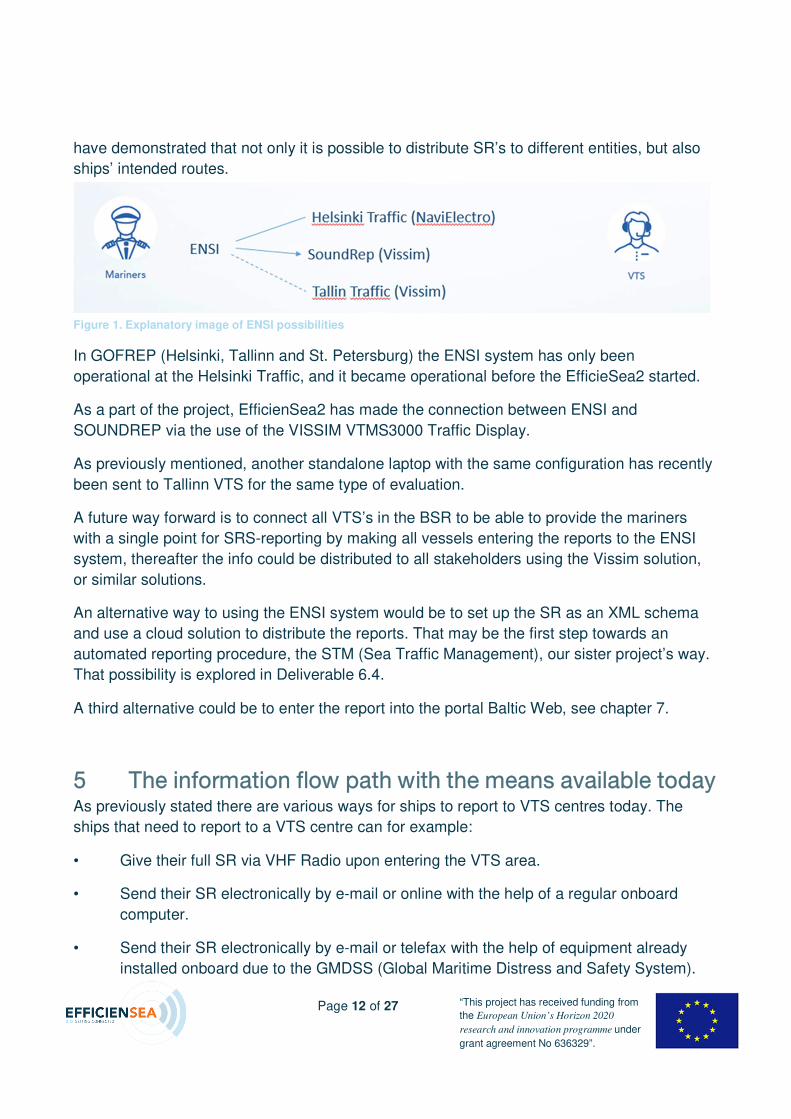
In GOFREP (Helsinki, Tallinn and St. Petersburg) the ENSI system has only been
operational at the Helsinki Traffic, and it became operational before the EfficieSea2 started.
As a part of the project, EfficienSea2 has made the connection between ENSI and
SOUNDREP via the use of the VISSIM VTMS3000 Traffic Display.
As previously mentioned, another standalone laptop with the same configuration has recently
been sent to Tallinn VTS for the same type of evaluation.
A future way forward is to connect all VTS’s in the BSR to be able to provide the mariners
with a single point for SRS-reporting by making all vessels entering the reports to the ENSI
system, thereafter the info could be distributed to all stakeholders using the Vissim solution,
or similar solutions.
An alternative way to using the ENSI system would be to set up the SR as an XML schema
and use a cloud solution to distribute the reports. That may be the first step towards an
automated reporting procedure, the STM (Sea Traffic Management), our sister project’s way.
That possibility is explored in Deliverable 6.4.
A third alternative could be to enter the report into the portal Baltic Web, see chapter 7.
R qÜÉ=áåÑçêã~íáçå=Ñäçï=é~íÜ=ïáíÜ=íÜÉ=ãÉ~åë=~î~áä~ÄäÉ=íçÇ~ó=As previously stated there are various ways for ships to report to VTS centres today. The
ships that need to report to a VTS centre can for example:
• Give their full SR via VHF Radio upon entering the VTS area.
• Send their SR electronically by e-mail or online with the help of a regular onboard
computer.
• Send their SR electronically by e-mail or telefax with the help of equipment already
installed onboard due to the GMDSS (Global Maritime Distress and Safety System).
Figure 1. Explanatory image of ENSI possibilities
Page 13 of 27 “This project has received funding from
the European Union’s Horizon 2020
research and innovation programme under
grant agreement No 636329”.
• If the ship is transiting GOFREP the ship can, submit their full SR together with their
route information via ENSI.
RKN oÉéçêíáåÖ=~í=pçìåÇ=sqp=
Today when a ship enters the SOUNDREP VTS area and gives their report via VHF Radio,
the VTSO writes down all the details on a piece of paper. When the report has been
completed the information is manually entered into the VTS Monitoring Software.
If a ship instead sends a digital report either via e-mail or using the online web form, the
information is received in the e-mail software and is manually transferred into the VTS
Monitoring Software.
When a digital report has been supplied by the ship, the ship just needs to communicate a
short verbal report upon entering the area - this is mostly to make sure that the ship is
listening to the correct VHF channel and an opportunity for the VTSO to supply the ship with
important and updated information about the ship’s present transit.
RKO oÉéçêíáåÖ=~í=eÉäëáåâá=qê~ÑÑáÅ=GOFREP is the mandatory reporting when you enter the Gulf of Finland or leave a port in the
Gulf of Finland. GOFREP consists of three SRS-centers - Helsinki Traffic, Tallinn Traffic and
St. Petersburg Traffic.
Reporting at GOFREP is conducted in a similar way as the reporting to Sound VTS.
However, at Helsinki Traffic today there is the opportunity to also submit SR and route via
ENSI. When a report is given through ENSI, the VTS Monitoring Software at Helsinki Traffic
automatically picks up the information and both the report and route is available for display
for the VTSO - right in the monitoring software, without any additional interaction.
The route can be given safety limits that will cause an alarm to go off at the VTS centre if a
vessel deviates from their intended route. This is a groundbreaking feature from a safety
perspective. The VTSO is alerted at a very early stage when a ship deviates from their
intended route. An additional safety layer has been added as the computer software takes
part in the traffic monitoring.
RKP bkpf=
ENSI is made available for free, as previously stated. This means that 3rd party suppliers and
service providers can integrate the ENSI information into their software by applying for a
certificate.
Page 14 of 27 “This project has received funding from
the European Union’s Horizon 2020
research and innovation programme under
grant agreement No 636329”.
RKQ ^fp=
“The regulation requires AIS to be fitted aboard all ships of 300 gross tonnage and upwards
engaged on international voyages” (Imo.org, 2017)
AIS is the most important tool for a VTS centre. It enables the VTSO to see a ship’s position,
speed, COG etc. in the VTS Monitoring Software.
S sfppfj=~åÇ=çíÜÉê=PêÇ=é~êíó=ëìééäáÉêë=
"Vissim is first of all a software house and the know-how is in our software. Deep
understanding of maritime technology and the information from all sensors and sources is
vital, but analyzing and transforming this information in a professional maritime management
system, is what brings the real value to our customers.
Vissim is based in Norway with offices in Slovakia, UK, Russia and China." (Vissim.no, 2017)
The reason for VISSIM being mentioned in this report is that Vissim is the first software
provider to integrate ENSI into their "Vissim Traffic Display [which] is using traditional
electronic charts. It has a multiple layers structure, including a custom layer editor and radar
video overlay. It supports a wide range of zones and fairways. Alarms can be configured for
targets entering/leaving zones, targets drifting off anchorage points and other significant
alarm triggers." (Vissim.no, 2017)
But just because Vissim is the first company to integrate the ENSI service into their already
running software, this does not mean that other similar companies cannot do the same. ENSI
is open and available to any interested company that gets approved and supplied with a
certificate.
SKN pí~åÇ~äçåÉ=ä~éíçéë=ïáíÜ=sfppfj=L=bkpf=
To be able to demonstrate what is possible to realize today by integrating towards ENSI,
Vissim has installed its VTMS3000 Traffic Display onto two regular laptops running Microsoft
Windows 10.
6.1.1 Integration VISSIM, ENSI and AIS
For the VTMS3000 Traffic Display to be of use for a user it has to get its source data supplied
by other systems. In the case of the demonstrative standalone laptops, an AIS feed has been
Page 15 of 27 “This project has received funding from
the European Union’s Horizon 2020
research and innovation programme under
grant agreement No 636329”.
provided by the SMA. This means that the VTMS3000 can display AIS targets that are visible
to SMA just by being connected to the Internet.
ENSI has also been integrated into VTMS3000 which makes it possible for the user to
display SR’s and ship routes directly in the VTMS3000 Traffic Display. The same is true for
ENSI to work - all that is needed is that the laptop is connected to the Internet.
6.1.1.1 VISSIM VTMS3000 Traffic Display
The VTMS3000 Traffic Display is described in detail in Deliverable 6.2. Chapter 3, Vissim
VTMS software.
T rëÉ=Å~ëÉë=ëí~åÇ~äçåÉ=ä~éíçé=This section will present two different use cases that have been recorded on one of the
standalone laptops.
• The first case shows a voyage through the Sound VTS monitoring area.
• The second case shows a route that terminates in Amsterdam which demonstrates that
any uploaded route can be displayed meaning that sharing of routes is not limited to the
BSR, but could in the future be used globally.
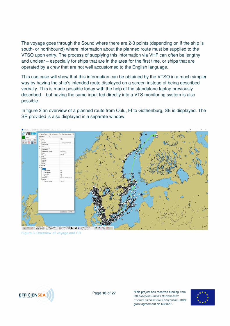
TKN sçó~ÖÉ=lìäìI=cf=Ó=dçíÜÉåÄìêÖI=pb=
The first use case will show a voyage from Oulu in Finland to Gothenburg in Sweden.
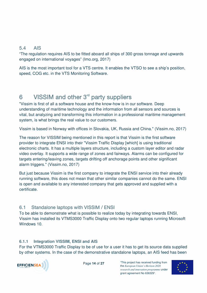
Figure 2. Information about VTMS3000 Traffic Display
Page 16 of 27 “This project has received funding from
the European Union’s Horizon 2020
research and innovation programme under
grant agreement No 636329”.
The voyage goes through the Sound where there are 2-3 points (depending on if the ship is
south- or northbound) where information about the planned route must be supplied to the
VTSO upon entry. The process of supplying this information via VHF can often be lengthy
and unclear – especially for ships that are in the area for the first time, or ships that are
operated by a crew that are not well accustomed to the English language.
This use case will show that this information can be obtained by the VTSO in a much simpler
way by having the ship’s intended route displayed on a screen instead of being described
verbally. This is made possible today with the help of the standalone laptop previously
described – but having the same input fed directly into a VTS monitoring system is also
possible.
In figure 3 an overview of a planned route from Oulu, FI to Gothenburg, SE is displayed. The
SR provided is also displayed in a separate window.
Figure 3. Overview of voyage and SR
Page 17 of 27 “This project has received funding from
the European Union’s Horizon 2020
research and innovation programme under
grant agreement No 636329”.
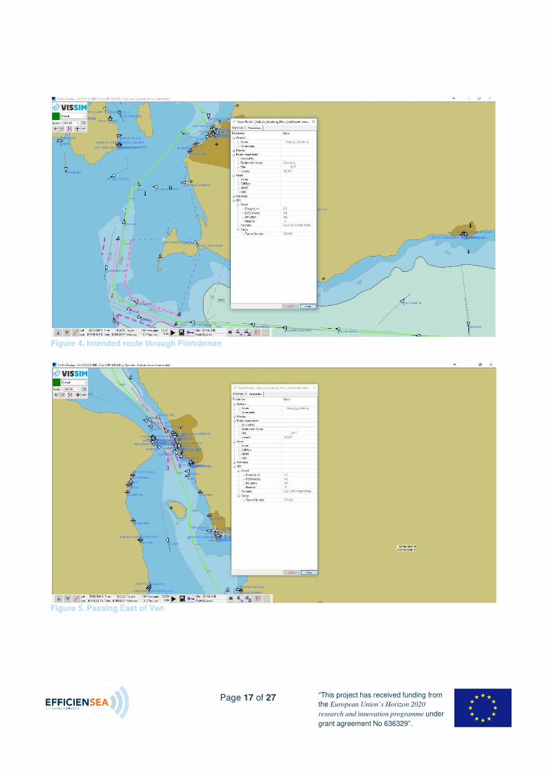
Figure 4. Intended route through Flintrännan
Figure 5. Passing East of Ven
Page 18 of 27 “This project has received funding from
the European Union’s Horizon 2020
research and innovation programme under
grant agreement No 636329”.
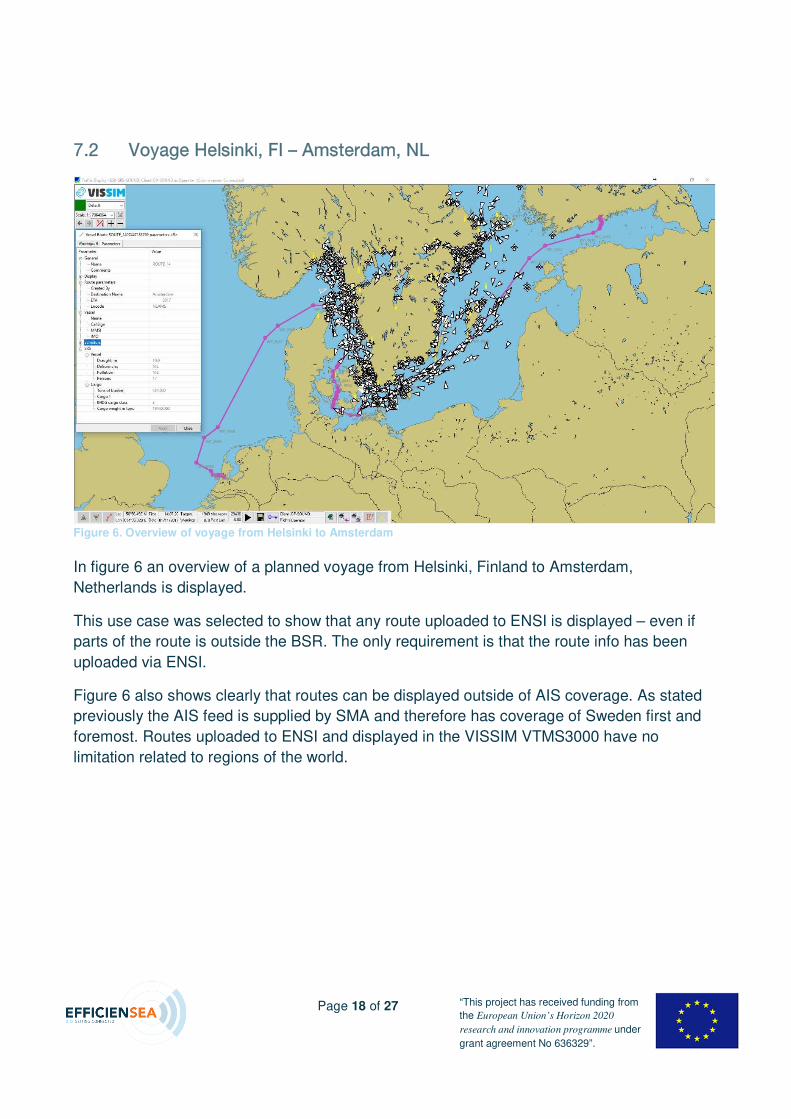
TKO sçó~ÖÉ=eÉäëáåâáI=cf=Ó=^ãëíÉêÇ~ãI=ki=
In figure 6 an overview of a planned voyage from Helsinki, Finland to Amsterdam,
Netherlands is displayed.
This use case was selected to show that any route uploaded to ENSI is displayed – even if
parts of the route is outside the BSR. The only requirement is that the route info has been
uploaded via ENSI.
Figure 6 also shows clearly that routes can be displayed outside of AIS coverage. As stated
previously the AIS feed is supplied by SMA and therefore has coverage of Sweden first and
foremost. Routes uploaded to ENSI and displayed in the VISSIM VTMS3000 have no
limitation related to regions of the world.
Figure 6. Overview of voyage from Helsinki to Amsterdam
Page 19 of 27 “This project has received funding from
the European Union’s Horizon 2020
research and innovation programme under
grant agreement No 636329”.
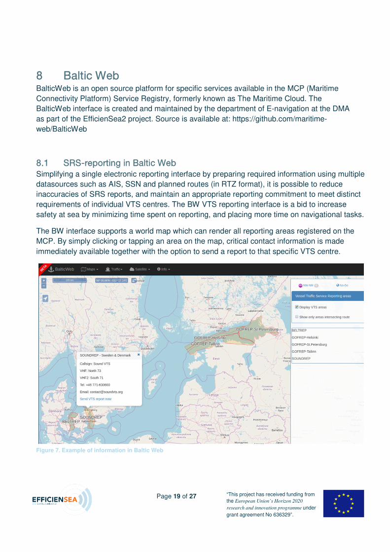
U _~äíáÅ=tÉÄ=BalticWeb is an open source platform for specific services available in the MCP (Maritime
Connectivity Platform) Service Registry, formerly known as The Maritime Cloud. The
BalticWeb interface is created and maintained by the department of E-navigation at the DMA
as part of the EfficienSea2 project. Source is available at: https://github.com/maritime-
web/BalticWeb
UKN popJêÉéçêíáåÖ=áå=_~äíáÅ=tÉÄ=
Simplifying a single electronic reporting interface by preparing required information using multiple
datasources such as AIS, SSN and planned routes (in RTZ format), it is possible to reduce
inaccuracies of SRS reports, and maintain an appropriate reporting commitment to meet distinct
requirements of individual VTS centres. The BW VTS reporting interface is a bid to increase
safety at sea by minimizing time spent on reporting, and placing more time on navigational tasks.
The BW interface supports a world map which can render all reporting areas registered on the
MCP. By simply clicking or tapping an area on the map, critical contact information is made
immediately available together with the option to send a report to that specific VTS centre.
Figure 7. Example of information in Baltic Web
Page 20 of 27 “This project has received funding from
the European Union’s Horizon 2020
research and innovation programme under
grant agreement No 636329”.
It is entirely possible that a ship’s master would wish to keep reporting over radio or telephone, so
simply using the BW interface as a single point of reference for contact details, which can be
updated immediately by each VTS centre, assures the master that the contact information is
current and reliable, possibly reducing time spent looking at manual notes or online webpages.
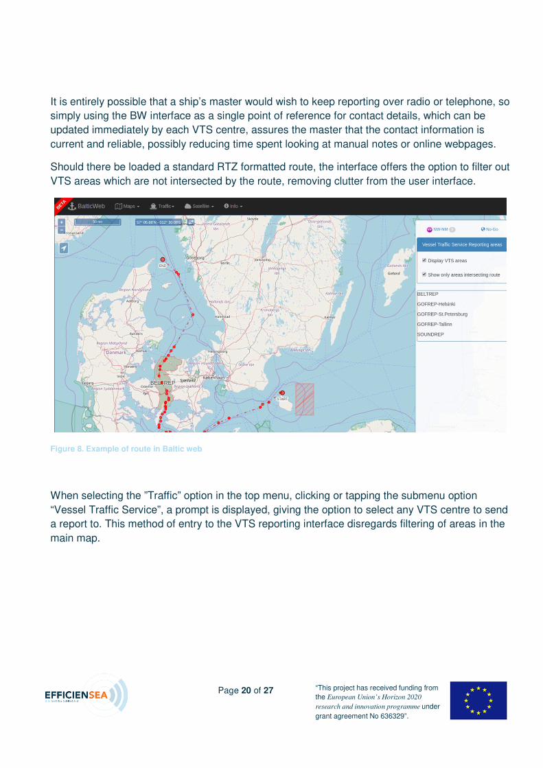
Should there be loaded a standard RTZ formatted route, the interface offers the option to filter out
VTS areas which are not intersected by the route, removing clutter from the user interface.
When selecting the ”Traffic” option in the top menu, clicking or tapping the submenu option
“Vessel Traffic Service”, a prompt is displayed, giving the option to select any VTS centre to send
a report to. This method of entry to the VTS reporting interface disregards filtering of areas in the
main map.
Figure 8. Example of route in Baltic web
Page 21 of 27 “This project has received funding from
the European Union’s Horizon 2020
research and innovation programme under
grant agreement No 636329”.
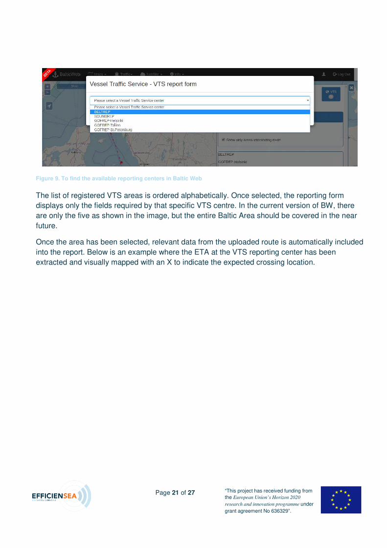
The list of registered VTS areas is ordered alphabetically. Once selected, the reporting form
displays only the fields required by that specific VTS centre. In the current version of BW, there
are only the five as shown in the image, but the entire Baltic Area should be covered in the near
future.
Once the area has been selected, relevant data from the uploaded route is automatically included
into the report. Below is an example where the ETA at the VTS reporting center has been
extracted and visually mapped with an X to indicate the expected crossing location.
Figure 9. To find the available reporting centers in Baltic Web
Page 22 of 27 “This project has received funding from
the European Union’s Horizon 2020
research and innovation programme under
grant agreement No 636329”.
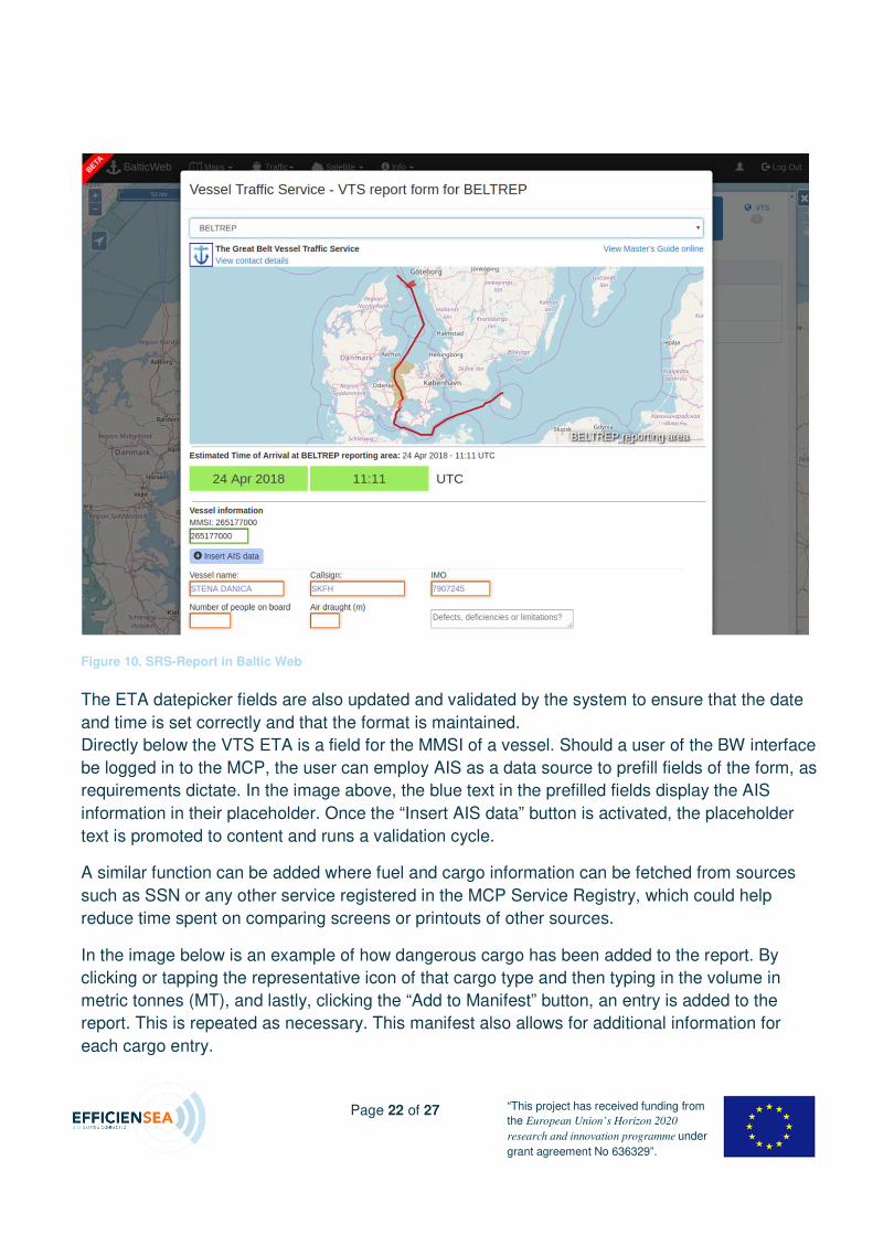
The ETA datepicker fields are also updated and validated by the system to ensure that the date
and time is set correctly and that the format is maintained.
Directly below the VTS ETA is a field for the MMSI of a vessel. Should a user of the BW interface
be logged in to the MCP, the user can employ AIS as a data source to prefill fields of the form, as
requirements dictate. In the image above, the blue text in the prefilled fields display the AIS
information in their placeholder. Once the “Insert AIS data” button is activated, the placeholder
text is promoted to content and runs a validation cycle.
A similar function can be added where fuel and cargo information can be fetched from sources
such as SSN or any other service registered in the MCP Service Registry, which could help
reduce time spent on comparing screens or printouts of other sources.
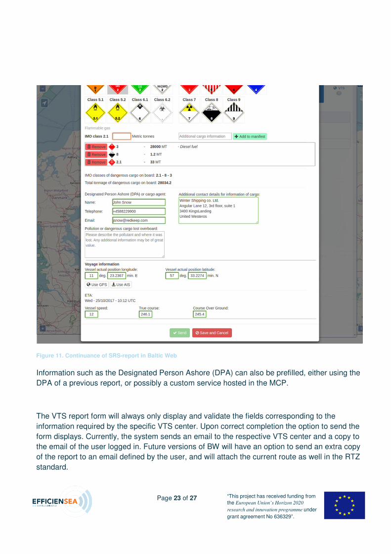
In the image below is an example of how dangerous cargo has been added to the report. By
clicking or tapping the representative icon of that cargo type and then typing in the volume in
metric tonnes (MT), and lastly, clicking the “Add to Manifest” button, an entry is added to the
report. This is repeated as necessary. This manifest also allows for additional information for
each cargo entry.
Figure 10. SRS-Report in Baltic Web
Page 23 of 27 “This project has received funding from
the European Union’s Horizon 2020
research and innovation programme under
grant agreement No 636329”.
Information such as the Designated Person Ashore (DPA) can also be prefilled, either using the
DPA of a previous report, or possibly a custom service hosted in the MCP.
The VTS report form will always only display and validate the fields corresponding to the
information required by the specific VTS center. Upon correct completion the option to send the
form displays. Currently, the system sends an email to the respective VTS center and a copy to
the email of the user logged in. Future versions of BW will have an option to send an extra copy
of the report to an email defined by the user, and will attach the current route as well in the RTZ
standard.
Figure 11. Continuance of SRS-report in Baltic Web
Page 24 of 27 “This project has received funding from
the European Union’s Horizon 2020
research and innovation programme under
grant agreement No 636329”.
V pìãã~êó=By using the standalone laptop running VTMS3000 Traffic Display with ENSI integration, this
reports demonstrates the possibility of connecting various systems with each other to create a
more detailed overview which could be available for all VTS centres within BSR.
This solution for obtaining ship reports and routes can be integrated directly into a VTS centre’s
already running software.
From the OOW’s point of view, the administrative burden can be reduced significantly because
information can be shared electronically and be shared by multiple VTS centres, and the ship’s
intended track is known to all relevant authorities beforehand.
By automatically obtaining ship routing information electronically, the software running at a
VTS centre can be programmed to insert safety limits for route deviations and alert the VTSO
of such deviations. This increases safety within a VTS area as the VTSO is made aware of
deviations from the ship at a much earlier stage compared to today’s practice.
The route that is uploaded to ENSI is cross checked by the ENSI software. This means that an
additional external route cross check takes place as compared to just a single route cross
check on board (as is mostly the case today). By using more than one system to perform such
a route cross check, the accuracy of the route with regard to safety is increased.
By using the standalone laptop as a demonstrator for obtaining ship reports and automatically
display ships’ intended routes, it has been shown that without too much effort, third party
software developers can utilize and exploit an already existing system for including this
functionality into their own software. The information captured by the ENSI system can be
made available to other interested software suppliers, not just Vissim.
The advantages for a VTS centre to have such information more easily available is valuable
– it means that the VTSO can focus more on the traffic situation in the area, something which
again will contribute to improved safety. This is also true for the OOW who has to do less
reporting because the information that is supplied one time, will be made available to more
than one VTS centre if desired.
In the future this sort of route exchange could possibly be made available for direct
transmission between ships as well. This would make intentions clearer and radio
communication could be even further decreased – which is always of interest.
The BW presents a solution where the ship’s route is filtering the information. The ship only
gets a selection of SRS’s that needs to be filled out along the route; not all SRS’s in the area.
The SRS’s are prefilled as much as is available to ease the work load on-board.
Page 25 of 27 “This project has received funding from
the European Union’s Horizon 2020
research and innovation programme under
grant agreement No 636329”.
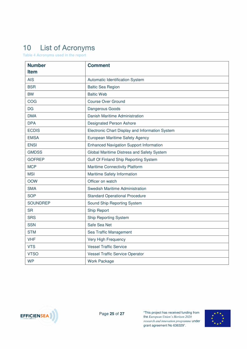
NM iáëí=çÑ=^Åêçåóãë=Table 4 Acronyms used in the report
Number
Item
Comment
AIS Automatic Identification System
BSR Baltic Sea Region
BW Baltic Web
COG Course Over Ground
DG Dangerous Goods
DMA Danish Maritime Administration
DPA Designated Person Ashore
ECDIS Electronic Chart Display and Information System
EMSA European Maritime Safety Agency
ENSI Enhanced Navigation Support Information
GMDSS Global Maritime Distress and Safety System
GOFREP Gulf Of Finland Ship Reporting System
MCP Maritime Connectivity Platform
MSI Maritime Safety Information
OOW Officer on watch
SMA Swedish Maritime Administration
SOP Standard Operational Procedure
SOUNDREP Sound Ship Reporting System
SR Ship Report
SRS Ship Reporting System
SSN Safe Sea Net
STM Sea Traffic Management
VHF Very High Frequency
VTS Vessel Traffic Service
VTSO Vessel Traffic Service Operator
WP Work Package
Page 26 of 27 “This project has received funding from
the European Union’s Horizon 2020
research and innovation programme under
grant agreement No 636329”.
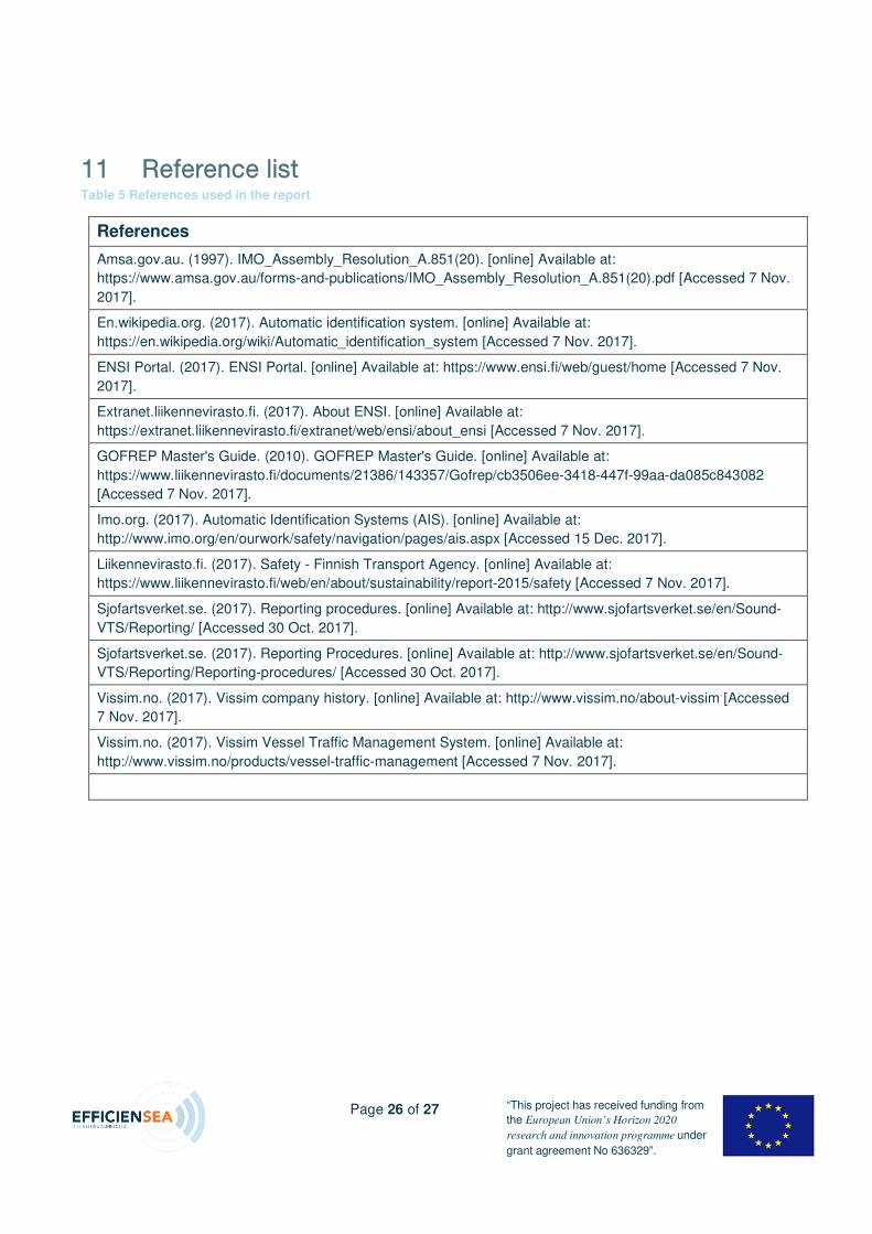
NN oÉÑÉêÉåÅÉ=äáëí=Table 5 References used in the report
References
Amsa.gov.au. (1997). IMO_Assembly_Resolution_A.851(20). [online] Available at:
https://www.amsa.gov.au/forms-and-publications/IMO_Assembly_Resolution_A.851(20).pdf [Accessed 7 Nov.
2017].
En.wikipedia.org. (2017). Automatic identification system. [online] Available at:
https://en.wikipedia.org/wiki/Automatic_identification_system [Accessed 7 Nov. 2017].
ENSI Portal. (2017). ENSI Portal. [online] Available at: https://www.ensi.fi/web/guest/home [Accessed 7 Nov.
2017].
Extranet.liikennevirasto.fi. (2017). About ENSI. [online] Available at:
https://extranet.liikennevirasto.fi/extranet/web/ensi/about_ensi [Accessed 7 Nov. 2017].
GOFREP Master's Guide. (2010). GOFREP Master's Guide. [online] Available at:
https://www.liikennevirasto.fi/documents/21386/143357/Gofrep/cb3506ee-3418-447f-99aa-da085c843082
[Accessed 7 Nov. 2017].
Imo.org. (2017). Automatic Identification Systems (AIS). [online] Available at:
http://www.imo.org/en/ourwork/safety/navigation/pages/ais.aspx [Accessed 15 Dec. 2017].
Liikennevirasto.fi. (2017). Safety - Finnish Transport Agency. [online] Available at:
https://www.liikennevirasto.fi/web/en/about/sustainability/report-2015/safety [Accessed 7 Nov. 2017].
Sjofartsverket.se. (2017). Reporting procedures. [online] Available at: http://www.sjofartsverket.se/en/Sound-
VTS/Reporting/ [Accessed 30 Oct. 2017].
Sjofartsverket.se. (2017). Reporting Procedures. [online] Available at: http://www.sjofartsverket.se/en/Sound-
VTS/Reporting/Reporting-procedures/ [Accessed 30 Oct. 2017].
Vissim.no. (2017). Vissim company history. [online] Available at: http://www.vissim.no/about-vissim [Accessed
7 Nov. 2017].
Vissim.no. (2017). Vissim Vessel Traffic Management System. [online] Available at:
http://www.vissim.no/products/vessel-traffic-management [Accessed 7 Nov. 2017].
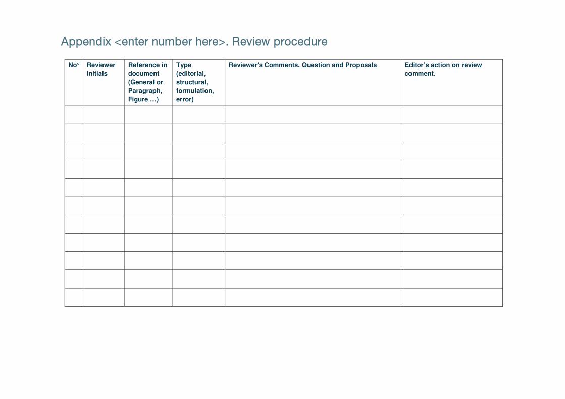
^ééÉåÇáñ=YÉåíÉê=åìãÄÉê=ÜÉêÉ[K=oÉîáÉï=éêçÅÉÇìêÉ=
No° Reviewer
Initials
Reference in
document
(General or
Paragraph,
Figure …)
Type
(editorial,
structural,
formulation,
error)
Reviewer's Comments, Question and Proposals Editor’s action on review
comment.


![Administering Cisco VTS · admin@VTS-A:~$ sudo su [sudo] password for admin: Step2 SourcetheVTSenvironment. root@VTS-A:# source /etc/profile.d/ncs.sh Step3 VerifyVTSstatus. root@VTS-A:#](https://img.pdfslide.us/doc/110x75/5ec8e3d704a90406890d6ec6/administering-cisco-vts-adminvts-a-sudo-su-sudo-password-for-admin-step2.jpg)