Embed Size (px)
Citation preview
The 4th International Conference of the International Forum on Urbanism (IFoU)
2009 Amsterdam/Delft
The New Urban Question – Urbanism beyond Neo-Liberalism
647
GRAND TAIPEI: THE POROUS CITY A RESEARCH ON THE URBAN FORM OF A POSTCOLONIAL CITY
Kuanchung Huang
EMU, TU Delft, the Netherlands, [email protected]
1 INTRODUCTION 1.1 Mobility urbanism
A metropolitan area It is a matter of time competing with space. When rapid transportation can access to larger territory
within the same time consuming as usual, the scale concerning a city is radically altered. Today, the definition of a metropolitan usually refers to a metro area which is the area served by the urban metro system.1 The efficiency of urban mobility brings a city to regional scale.
The competitive transportation mode Urban mobility can be varied. There is no single transportation mode used to serve the regional city.
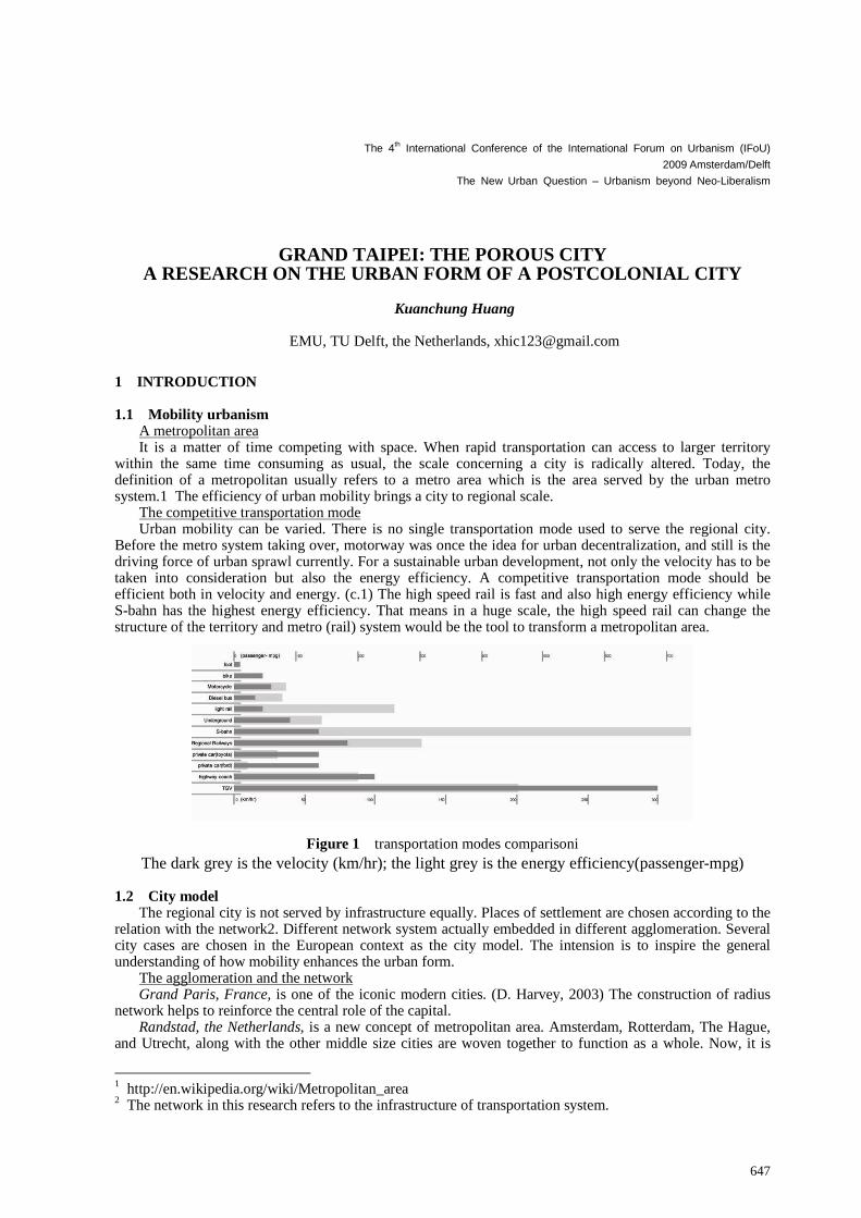
Before the metro system taking over, motorway was once the idea for urban decentralization, and still is the driving force of urban sprawl currently. For a sustainable urban development, not only the velocity has to be taken into consideration but also the energy efficiency. A competitive transportation mode should be efficient both in velocity and energy. (c.1) The high speed rail is fast and also high energy efficiency while S-bahn has the highest energy efficiency. That means in a huge scale, the high speed rail can change the structure of the territory and metro (rail) system would be the tool to transform a metropolitan area.
Figure 1 transportation modes comparisoni The dark grey is the velocity (km/hr); the light grey is the energy efficiency(passenger-mpg)
1.2 City model
The regional city is not served by infrastructure equally. Places of settlement are chosen according to the relation with the network2. Different network system actually embedded in different agglomeration. Several city cases are chosen in the European context as the city model. The intension is to inspire the general understanding of how mobility enhances the urban form.
The agglomeration and the network Grand Paris, France, is one of the iconic modern cities. (D. Harvey, 2003) The construction of radius
network helps to reinforce the central role of the capital. Randstad, the Netherlands, is a new concept of metropolitan area. Amsterdam, Rotterdam, The Hague,
and Utrecht, along with the other middle size cities are woven together to function as a whole. Now, it is
1 http://en.wikipedia.org/wiki/Metropolitan_area 2 The network in this research refers to the infrastructure of transportation system.
648
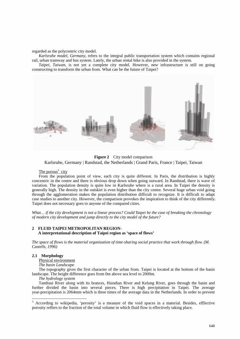
regarded as the polycentric city model. Karlsruhe model, Germany, refers to the integral public transportation system which contains regional
rail, urban tramway and bus system. Lately, the urban rental bike is also provided in the system. Taipei, Taiwan, is not yet a complete city model. However, new infrastructure is still on going
constructing to transform the urban from. What can be the future of Taipei?
Figure 2 City model comparison Karlsruhe, Germany | Randstad, the Netherlands | Grand Paris, France | Taipei, Taiwan
The porous3 city From the population point of view, each city is quite different. In Paris, the distribution is highly
concentric in the centre and there is obvious drop down when going outward. In Randstad, there is wave of variation. The population density is quite low in Karlsruhe where is a rural area. In Taipei the density is generally high. The density in the outskirt is even higher than the city centre. Several huge urban void going through the agglomeration makes the population distribution difficult to recognize. It is difficult to adapt case studies to another city. However, the comparison provokes the inspiration to think of the city differently. Taipei does not necessary goes to anyone of the compared cities. What… if the city development is not a linear process? Could Taipei be the case of breaking the chronology of modern city development and jump directly to the city model of the future?
2 FLUID TAIPEI METROPOLITAN REGION-
A interpretational description of Taipei region as ‘space of flows’ The space of flows is the material organization of time-sharing social practice that work through flow. (M. Castells, 1996) 2.1 Morphology
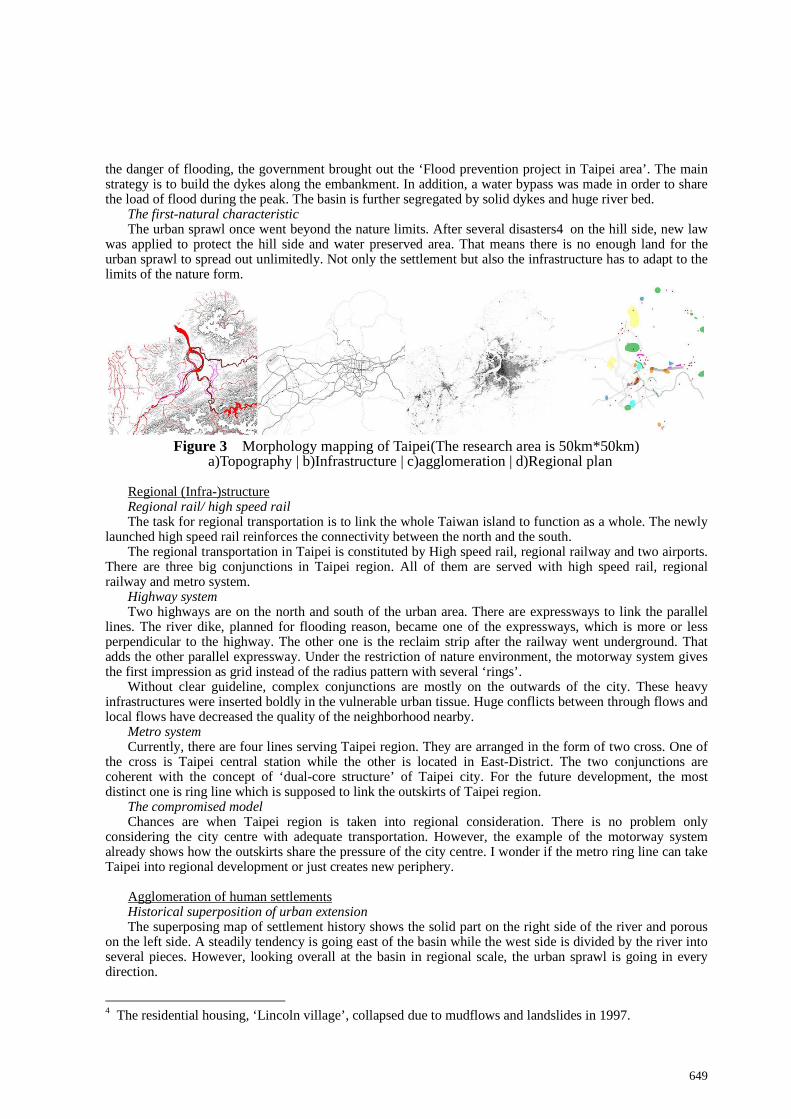
Physical environment The basin Landscape The topography gives the first character of the urban from. Taipei is located at the bottom of the basin
landscape. The height difference goes from 0m above sea level to 2000m. The hydrology system Tamhsui River along with its brances, Hsindian River and Kelung River, goes through the basin and
further divided the basin into several pieces. There is high precipitation in Taipei. The average year-precipitation is 2064mm which is three times of the average data in the Netherlands. In order to prevent
3 According to wikipedia, ‘porosity’ is a measure of the void spaces in a material. Besides, efffective porosity reffers to the fraction of the total volume in which fluid flow is effectively taking place.
649
the danger of flooding, the government brought out the ‘Flood prevention project in Taipei area’. The main strategy is to build the dykes along the embankment. In addition, a water bypass was made in order to share the load of flood during the peak. The basin is further segregated by solid dykes and huge river bed.
The first-natural characteristic The urban sprawl once went beyond the nature limits. After several disasters4 on the hill side, new law
was applied to protect the hill side and water preserved area. That means there is no enough land for the urban sprawl to spread out unlimitedly. Not only the settlement but also the infrastructure has to adapt to the limits of the nature form.
Figure 3 Morphology mapping of Taipei(The research area is 50km*50km)
a)Topography | b)Infrastructure | c)agglomeration | d)Regional plan
Regional (Infra-)structure Regional rail/ high speed rail The task for regional transportation is to link the whole Taiwan island to function as a whole. The newly
launched high speed rail reinforces the connectivity between the north and the south. The regional transportation in Taipei is constituted by High speed rail, regional railway and two airports.
There are three big conjunctions in Taipei region. All of them are served with high speed rail, regional railway and metro system.
Highway system Two highways are on the north and south of the urban area. There are expressways to link the parallel
lines. The river dike, planned for flooding reason, became one of the expressways, which is more or less perpendicular to the highway. The other one is the reclaim strip after the railway went underground. That adds the other parallel expressway. Under the restriction of nature environment, the motorway system gives the first impression as grid instead of the radius pattern with several ‘rings’.
Without clear guideline, complex conjunctions are mostly on the outwards of the city. These heavy infrastructures were inserted boldly in the vulnerable urban tissue. Huge conflicts between through flows and local flows have decreased the quality of the neighborhood nearby.
Metro system Currently, there are four lines serving Taipei region. They are arranged in the form of two cross. One of
the cross is Taipei central station while the other is located in East-District. The two conjunctions are coherent with the concept of ‘dual-core structure’ of Taipei city. For the future development, the most distinct one is ring line which is supposed to link the outskirts of Taipei region.
The compromised model Chances are when Taipei region is taken into regional consideration. There is no problem only
considering the city centre with adequate transportation. However, the example of the motorway system already shows how the outskirts share the pressure of the city centre. I wonder if the metro ring line can take Taipei into regional development or just creates new periphery.
Agglomeration of human settlements Historical superposition of urban extension The superposing map of settlement history shows the solid part on the right side of the river and porous
on the left side. A steadily tendency is going east of the basin while the west side is divided by the river into several pieces. However, looking overall at the basin in regional scale, the urban sprawl is going in every direction.
4 The residential housing, ‘Lincoln village’, collapsed due to mudflows and landslides in 1997.
650
Urban tissue There is clear urban tissue in the old city centre. Different tissues in the history are woven together.
However, outside the city centre, especially on the opposite side of the river, the tissue is not well organized. The former derives from the urban plan in Japanese colonial period. The latter suffered from the rapid urban sprawl after world war.
The mixed and diverse features area In Taipei, no single centrality is identified. There are different stories for different areas. Each story told
the story of its own. The diverse and mixed activities present Taipei as a chaotic but vivid city. It is like a song composed by random generator, ‘a song without rhythm5’. Similar urban landscape can be found in old city centre, new CBD or new residential district. On the other hands, each features area has its own autonomy. For example, a Taipei person would choose the restaurant in very different part of the city according to the meeting topic and the guests.
City program Regional plan Dual-core structure was proposed for Taipei city by the government. However, there is no clear structure
in the regional scale6. The map of ‘strategic proposal’ is illustrated from different projects. These projects are designed in different scales and are under different concerns. What in common is the new opportunity brought in by new infrastructure. What lacks is the coherency between projects. The projects can be varied and the infrastructure supporting the local development is also different. Metro line, expressway, provincial roads are all related but not integrated.
Placeless functional nodes The emergence of space of flows is due to the new information technology.(M. Castells, 1989) When it
comes to city scale in physical environment, the infrastructure would be the tool to support the physical flow. For the city developing strategy, places are chosen according to its relation with the network. The infrastructure is the imaginary structure of the basin landscape. However, the regional plan only makes partial use of the infrastructure fragmentally. The accessibility to transportation on the map shows the placeless nodes of network which support the city development. Does the equalized accessibility to transportation enhance the homogenized urban environment? 2.2 Chronology: the fluid centrality
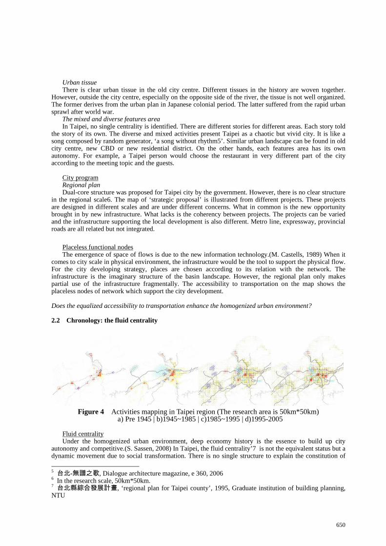
Figure 4 Activities mapping in Taipei region (The research area is 50km*50km)
a) Pre 1945 | b)1945~1985 | c)1985~1995 | d)1995-2005
Fluid centrality Under the homogenized urban environment, deep economy history is the essence to build up city
autonomy and competitive.(S. Sassen, 2008) In Taipei, the fluid centrality’7 is not the equivalent status but a dynamic movement due to social transformation. There is no single structure to explain the constitution of
5 台北-無譜之歌, Dialogue architecture magazine, e 360, 2006 6 In the research scale, 50km*50km. 7 台北縣綜合發展計畫, ‘regional plan for Taipei county’, 1995, Graduate institution of building planning, NTU
651
the city activities. The mixed urban activities are not coherent to the city plan executed by the government. The multiple colonial histories resulted in the mixed urban activities.
The effort of the interpretational mapping is to illustrate the flow of the activities in Taipei. The infrastructure implemented in coherent era is also illustrated in order to show how the infrastructure enhanced the city development.
Pre 1895: Settlement: the harbor towns The first settlement from mainland China arrived in 17th century. The towns were established close to
the river. Water route is the main transportation way. 1885, the Ching dynasty set the first government in Taipei and built the Taipei city wall. Meanwhile, San-shi-jie8 was the name of the city centre. The first railway was also constructed in order to transfer goods from the surrounding area to Taipei city.
1895-1945: Centralization: the colonial capital Taiwan was ceded to Japanese colonial government by Ching Dynasty 1985. The railway along the west
coast plain was accomplished in order to have fully access to the whole Taiwan island. From then on, Taipei was no doubt the capital of Taiwan.9
In the city scale, the Japanese government applied the modern city planning to re-adjust the city pattern. Grid system of streets was proposed. Sanshijie was further structured and extended. Due to the class difference between colonist and colonizer, different areas served different people. The ruling class, Japanese, occupied the city centre while Taiwanese ran their business in Dadaocheng. Hsimenting10 was where Japanese and Taiwanese mixed. It was recognized the central business centre at that time.
1945-1985: Decentralization: the periphery The national government (Chiang, Kaishek troop) from China took over the sovereignty from Japanese
colonial government. Latter on, the troop of national government withdrew from the civil war in China and came to Taiwan. New ruling class and settlement arrived. It was the time after world war. For security reason, new neighborhood was settled outside the city centre. Infrastructure was constructed to reinforce the centrality. Clear difference and segregation between the city centre and outskirts became recognizable.
Due to the regulation of zoning, some production activities were not allowed in the ‘zone’; thus, they moved out. The constant flow of production activities can be seen from the history. For the flexibility and ephermerality of industry type, it can fit in different situation.
1985-1995; Mutation: urban sprawl The martial law was declared ended in 1985. It was the time after the rapid economy growing for twenty
years. The real estate business became popular. The urban development was driven by the opportunistic private developers.
By means of ‘Flood prevention project in Taipei area’ which proposed the dike along the river embankment, the expressway can be constructed on top of the dyke. The extension of highway, along with the embankment expressway, the infrastructure tended to transform the city to automobile oriented.
SOGO Pacific department store, was open in 1985. The area was called as ‘east district’ which showed the location difference to the old city centre. The east district of Taipei presented a hip and chic urban image while the old city centre, Hsimending, started to suffered from urban decay.
1995-2009: Evolution: dual core city structure ‘Dual-core structure’ is proposed for the city centrality. Hsinyi District, where is on the east of East
District of Taipei, was proposed by the government to be the new CBD. The metro reinforce the connection between the old city centre, East District and Hsinyi district.
The traces of the flows The superposition of centralities From Hsimending, East District, to Hsinyi District, it is a continuous urban area with the variation of
centrality. Lively urban activities are interwoven irregularly in the urban tissue. When the activities move from one place to another, they didn’t move thoroughly. Some of the traces were left. As a result, the superposition of mixed activities is obvious in current Taipei urban area. The same situation can also be investigated all around the agglomeration.
8 Sanshijie:三市街, also means ‘three districts’. It is the combination of three parts: Manka, Dadaocheng and the wall city. 9 Before Taipei became the capital, Tainan was the capital followed by Lukang. 10 Hsimending: 西門町 Hsimending is more or less the same area as Manka, the former city centre before Dadaocheng.

652
The meaning of East-District in the space of flows The urban experience in East District and Hsinyi District is an evident example to show the movement of
flow. The orientation is Hsimending, East-District and Hsinyi District in order. The order is also chronological. In general, East District refers to the east side of the original city centre which is Hsimending. When there was Hsinyi District on the east of East-District. The definition of ‘East’ district became blur; the centrality of ‘East’ district began to flow and merge together. Therefore, the area between the two became a continuous mixed urban area.
The trace of flow results in the overlapping of activities. The overlapping of big centrality makes a flawless continuity of urban environment.
3 ISOTROPIC REGION-
The research by design method
Scenario is the connection between the theoretical debates and the physical consequence. The scenario construction is the interpretational strategy confront with the existing problem statement. The consequence can be evaluated as the experiment. This approach tends to result in the design-research loop.
Taipei is historically and contemporary the space of flows. The action is centralization and decentralization. What crucial is the relation between the two process. I take the notion of ‘isotropy’ as respond. Isotropy is the movement in an effective porous environment where the flow is neither directional nor hierarchical. What… if the region is isotropic?
Figure 5 Illustration of homogenized urban environment 3.1 Generating the flow
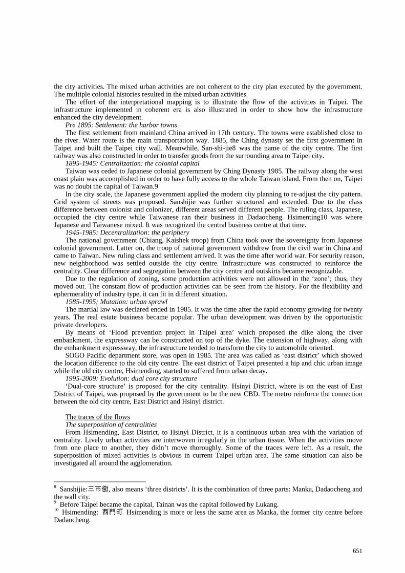
The rationalized map of Taipei is the interpretation of the existing urban environment in order to restructure an isotropic region.
653
Figure 6 Rationalized mapping of Taipei region a)accessibility points | b)global city | c)city of production | d)network city
Reforming urban structure The global city Two airports, high speed rail (THSR), along with the regional railway and airport transit are the nodes of
global citites. Only a few nodes are set. Taipei central station is the major conjunction. The city of production The highways and expressways constitute the express system. Along the motorway exchange, the
regional bus transportation connects the region with the rest of the territory. The logistic system also depends on automobile. The nodes benefiting business and production activities in the region are chosen.
The network city With the proposal of metro ring line the coming years, several minor conjunctions are launched along the
ring. Along with the other infrastructure, the concentric pattern is transferred into isotropic pattern. When the network is no longer treated as the radius pattern, the connection between systems can be easily joined. The long term perspective of the metro network is the web that serves the urban patch.
Urbanity generator The structure of flow The isotropic structure is the integration of different transportation mode. Superposing the nodes of every
system, the operational nodes can be re-loaded on the generator. Every node plays a certain function in relation to the system. There will be no single centrality in the centre. All of them present the centrality of the isotropic region
The continuity of flow Each metro station becomes an urbanity generator that brings new opportunity for development. They
generate the continuous urban area. Even the huge urban void can be easily cross. Isotropy is the connectivity serving a homogenized urban environment. Along with the urban activities, the urbanity generator can bloom into exotic flower.
The generator is the operational nodes of urbanity. Does the new centrality mean the urban spectacular? Under the symbolic building, there is the space for daily life.
3.2 Metro camp
Imagine! Just one metro stop away, you already arrive the other side of the void from downtown. The downtown here is Taipei central station and Hsimending and the other side is Sanchong. There is distinct characteristic for each area. They were segregate by Tamshui River physically. Historically, Hsimending was developed under well organized urban planning guidance; and Sanchong suffered from rapid urbanization in modern time.
With the proposed system, they are linked. The task here is to create the environment allowing flow. In other words, the design proposal is for space of flow. The metro station doesn’t arrive on a segregated point but on an area. The metro camp is the proposal to intervene the regional scale with the local scale.
Urban anchor The proposal dose not try to change the line or design the station. A mega building that provides all the
654
necessary for activities on multiple levels results in discontinuity and complexity. Related stations are designed to generate different places as a whole, the metro camp.
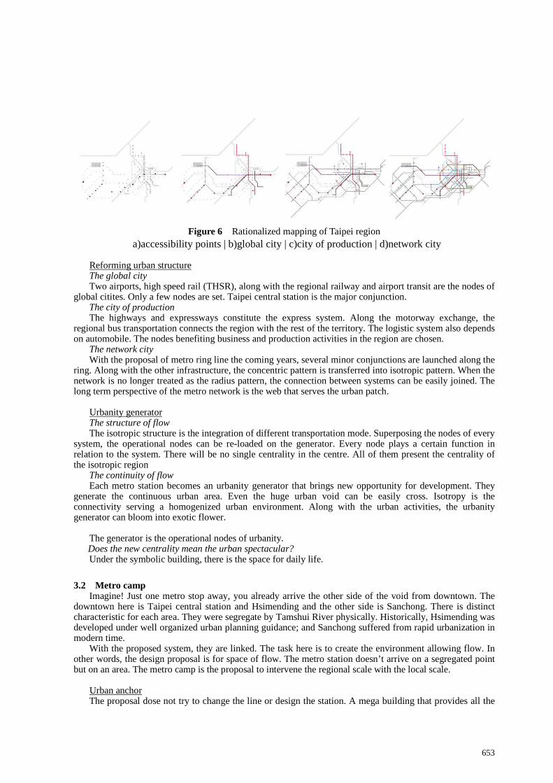
The existing urban tissue was developed under rapid urban sprawl. The continuity between different urban tissues is weak. The anchor can generate complex tissues and to create the continuity. As a result, all these urban anchor can be integrated in a larger scale. Hidden order is found and new axis is proposed.
Figure 7 Proposal for hybrid network (the research area is 20km*20km) a) metro system | b)motorway system | d)cycling route | d)reorganized urban tissue and axis
Hybrid network Four layers of mobility are integrated to serve the metro camp. Metro: From the regional structure, several nodes are given different importance. Motorway: Huge conjunction that decreased the urban quality should be avoided. In the designated site,
the bridge goes from Taipei city, Sanchong to Xinchong is redesigned to avoid through flow. Meanwhile, a bus terminal can be located.
Cycling route: The existing cycling route are along the river bed and serve only for recreation purpose. With the new proposal in the urban area, the cycling route system can also serve urban mobility.
Urban tissue: New axis generates the historical axis and the urban tissue between the huge urban void. New open space is also designed to accomplish the metro camp.
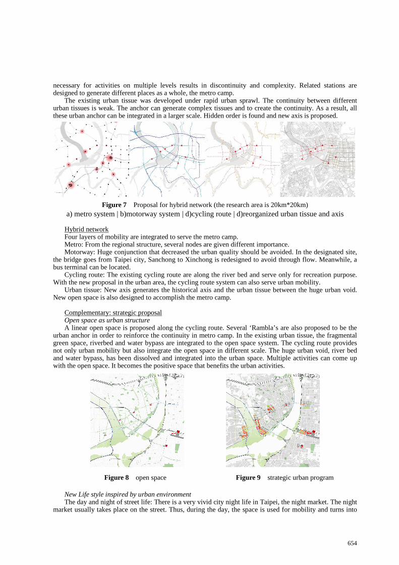
Complementary: strategic proposal Open space as urban structure A linear open space is proposed along the cycling route. Several ‘Rambla’s are also proposed to be the
urban anchor in order to reinforce the continuity in metro camp. In the existing urban tissue, the fragmental green space, riverbed and water bypass are integrated to the open space system. The cycling route provides not only urban mobility but also integrate the open space in different scale. The huge urban void, river bed and water bypass, has been dissolved and integrated into the urban space. Multiple activities can come up with the open space. It becomes the positive space that benefits the urban activities.
Figure 8 open space Figure 9 strategic urban program
New Life style inspired by urban environment The day and night of street life: There is a very vivid city night life in Taipei, the night market. The night
market usually takes place on the street. Thus, during the day, the space is used for mobility and turns into
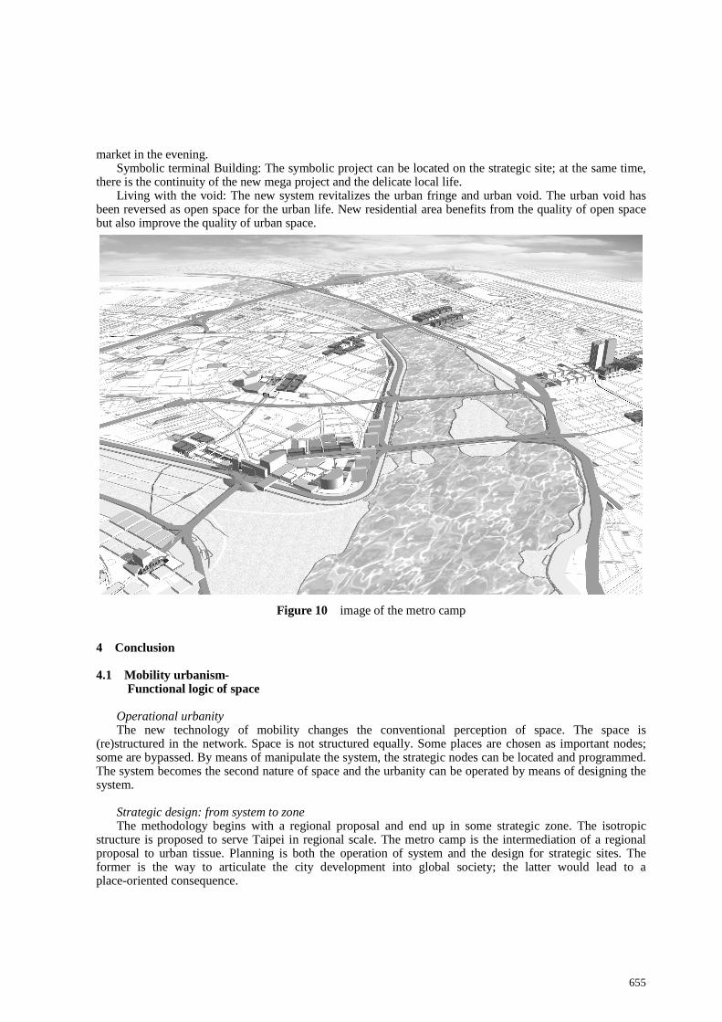
655
market in the evening. Symbolic terminal Building: The symbolic project can be located on the strategic site; at the same time,
there is the continuity of the new mega project and the delicate local life. Living with the void: The new system revitalizes the urban fringe and urban void. The urban void has
been reversed as open space for the urban life. New residential area benefits from the quality of open space but also improve the quality of urban space.
Figure 10 image of the metro camp
4 Conclusion 4.1 Mobility urbanism-
Functional logic of space
Operational urbanity The new technology of mobility changes the conventional perception of space. The space is
(re)structured in the network. Space is not structured equally. Some places are chosen as important nodes; some are bypassed. By means of manipulate the system, the strategic nodes can be located and programmed. The system becomes the second nature of space and the urbanity can be operated by means of designing the system.
Strategic design: from system to zone The methodology begins with a regional proposal and end up in some strategic zone. The isotropic
structure is proposed to serve Taipei in regional scale. The metro camp is the intermediation of a regional proposal to urban tissue. Planning is both the operation of system and the design for strategic sites. The former is the way to articulate the city development into global society; the latter would lead to a place-oriented consequence.
656
4.2 Porous urbanity- Network, Nodes and Hubs
Isotropy By means of operating the transportation network, the character of isotropy is reinforced. The
homogenized urban environment is served and structured by the isotropic connectivity. The operation of the mobility system empower each nodes a certain importance. These nodes can bloom into exotic flowers which present a diverse urban environment. Isotropic is neither homocentric nor polycentric. All of them present the centrality of Taipei region.
Permeability Metro and motorway system is the tool to operate the city development in regional scale. They become
only accessible points in the local scale, such as metro station (even the exit of the underground station) and motorway exchange. The huge infrastructure invading the urban tissue is dissolving into urban tissue. With the proposal for cycling route, it generates the slow network in urban mobility. The flawless connection between global transportation, regional transportation, and locale is created. Urban activities can be intervened without segregation in the mobility environment of flawless connection. At last, The exit of metro generates a space of place that articulate to the space of flow.
Void Only when the flow can go through the void, it becomes the open space for urban environment. There is
a thin line between the urban void and urban open space. The huge river bed going through Taipei Basin is recognized as urban void. The surrounding area becomes urban fringe. By means of permeable connectivity, open spaces in different scales are linked. They are: pedestrian, La Rambla, urban square and urban park. The void turns to activity platform that can benefit the urban life. 4.3 The form of the postcolonial city-
Space of places under globalization
Under globalization, the city is changing far beyond imagination. The new technology of infrastructure prompts the city into regional scale. The space is operated by the power of the flow. Space of flows is global, territorial and regional. Taipei presents the situation confronting space of flows both currently and historically. During the multiple colonial histories, the centrality of Taipei flew in time. The superposition of traces of flows makes Taipei with a huge continuous mixed use urban area. The infrastructure supports the urban from can go anywhere, even a homogenized urban environment with equalized accessibilities. Intervening with other layers of the physical environment, each urban generator blooms into a flower, flower of the place. At last, the research of Taipei tries to contribute to a more comprehensive understanding of city model. The porous city of Taipei present how can the space of flow embedded in place.
REFERENCE
[1] Calabrese, L. M., 2004, 《Reweaving uma- Urbanism, mobility, Architecture》 [2] Castells, M., 1989,《The informational city》 [3] Castells, M., 2000,《The Rise of the Network Society》 [4] Hsia, C.J., 2000, <殖民的現代性營造-重寫日本殖民時期台灣建築與城市的歷史> ,台社 [5] Harvey, D., 2003, 《 Paris, the capital of modernity》 [6] Vigano, P., 2007, <On porosity>, 《Permacity》, NL: TU Deflt [7] Sassen, S., 2008, <Inhabited infrastructure>, IUAV:49 [8] Studio 9, B. Secchin and P. Vigano, <The porous city>, 《Le grand Pari(s)》, Paris: amc Le moniteur architecture