Embed Size (px)
Citation preview

Cycling Expertise
Advantages for cyclists and municipalities
The conversion of disused railway lines makes it possi-ble to develop safe and comfortable cycle-path infra-structure with relatively little effort. Cycle paths on rail-way embankments can be used both as sections of the local cycle-route network in a city or municipality and as routes connecting various small towns and villages. The main advantage of railway-line cycle paths is that, like cycle routes along waterways, they stretch over rel-atively long distances well away from road traffic and therefore prevent dangerous encounters with cars and lorries.
Greenway Cycle Routes on Disused Railway Lines
New uses for disused railway lines
Over the past years and decades, the German railway Deutsche Bahn has closed numerous rail lines. These closures have mainly affected secondary lines in rural areas for which demand for passenger services had de-creased. With the significant decline in population and the considerable increase in automobile use in many re-gions, rail transport has been replaced by bus services to save money.
At the same time, operations were also ceased on many freight-only lines. Large steelworks, coal mines and oth-er production facilities have been closed, particularly in the old industrial centres, like the Ruhr region or Saar-land. Railway lines that once connected these sites to the railway system fell into disuse.
Closed railway lines remain the property of Deutsche Bahn or the respective former operator. Disused tracks and facilities cost money to maintain. At the same time, historically valuable railway buildings, operating facili-ties, bridges and other infrastructure along the disused lines also fall into disrepair, meaning that not only the owner is interested in a timely solution. If no other com-pany can be found to take over the line and resume ser-vices, an attempt is usually made to sell the property along which the tracks run. This opens up interesting op-portunities for the planning of cycling infrastructure.
Cover images: Greenway cycle routes “Münsterlandradweg” (left)© BEG NRW. “Erzbahn” (right) © Jörg Thiemann-Linden.
ContentsNew uses for disused railway lines 1
Advantages for cyclists and municipalities 1
Formal criteria 2
North Rhine-Westphalia: Regional association 2
Planning challenges 3
Practical examples 3
Conclusion 4

2 Cycling Expertise – Infrastructure I-15/2012
Website of the “Polish Environmental Partnership Foundation” with comprehensive information about Greenway(www.greenways.pl/en)
Website of the European Greenway Association (EGWA): (www.aevv-egwa.org/site/hp_en.asp)
Many of the structures found in places where the former rail lines intersect with roads offer safe and ideal cross-ing solutions for cyclists: e.g. bridges and viaducts that were built for railway traffic. The load-bearing capaci-ty of these structures – even if they date back many dec-ades and are starting to show their age – is sufficient for cycling traffic. Furthermore, as cycle-path infrastructure, these structures find a new purpose and are prevented from falling into disrepair.
Owing to their high level of road safety, railway-line cy-cle paths offer excellent places, away from road traffic, for introducing children to cycling and can also be used as low-risk routes for cycling to school.
In order to convert railway lines to cycle paths, only the tracks must be removed. The ballast bed is retained and provides an ideal foundation for the asphalt surface of the paths. In terms of gradient, railway lines are de-signed to accommodate trains, which can only handle gentle inclines of generally no more than 2.5 %. There-fore, railway-line cycle paths have no steep hills. On these paths altitude differences can be gracefully over-come with a moderate and constant slope. This fea-ture is especially favourable for older cyclists and fami-lies with children. In addition the cycle paths follow the same wide curves as the railway line and benefit from the generous width of the former track bed, which is generally at least 2.5 metres (8 ft).
For the most part, cycle paths on railway embankments are slightly elevated and, in many places, offer their us-ers an especially beautiful view of the surroundings, making the cycling experience even more enjoyable. The views from viaducts and bridges can be especially breathtaking.
Formal criteria
If the railway company relinquishes ownership of a for-mer line, many stakeholders, such as municipalities and private investors, have the opportunity to express inter-est in purchasing the line. These parties enter into nego-tiations with the railway company to determine the pur-chase price and the condition in which the line is to be handed over. Experts advise cities and municipalities in-terested in building cycle paths to accept the additional costs for the removal of the tracks and take over the land with nothing but the ballast bed, in order to avoid hav-ing to manage these costly measures on their own.
In Germany a relatively elaborate process of land reclas-sification must take place before railway property can be used for other purposes, e.g. as a cycle path. In this process the old line is officially released from railway use, and the dispensability of the line for rail transport demonstrated.
Nevertheless, railway lines that have been converted in-to cycle paths can still be reactivated for rail traffic at a later time because, when used in this way, the former line cannot be fragmented into small, individual proper-ties or broken up by transport structures, industrial parks or residential areas along the route. Along with the fu-ture reactivation for rail transport, railway-line cycle paths also allow for the laying of power lines parallel to the path, opening up possibilities in the area of power supply.
North Rhine-Westphalia: Regional association for the creation of railway-line cycle paths
The German state of North Rhine-Westphalia, togeth-er with Deutsche Bahn, founded the railway proper-ty development company ‘Bahnflächenentwicklungsge-sellschaft’ (BEG) and, in 2007, launched the programme ‘BahnRadwegeInitiativen NRW’ for railway-line cycle path projects. This is the first integrative project on the state level in Germany aimed at promoting the conver-
Further ReadingInternet portal of the US-American interest group “Rails-to-Trails Conservancy” (www.railstotrails.org/)
Greenway cycle route “Münsterlandradweg” and railway line near Münster© BEG NRW
3Cycling Expertise – Infrastructure I-15/2012
sion of disused railway lines into cycle paths on a large scale.
The BEG has developed a comprehensive strategy that includes all important aspects, from the concept and process control to implementation. In addition a list has been made of all disused railway lines in the state that could potentially be used as cycle paths. In total, more than 300 of the 550 kilometres (190 of the 340 miles) of abandoned railway lines are planned for conversion. The programme supports municipalities in various ways, such as the negotiation of a price for the disused lines, the clarification of legal considerations, the calculation of associated costs, the planning and implementation of construction measures and the use of available funding opportunities.
Planning challenges
For cycle paths on elevated railway platforms, structur-al measures are required to provide access to the paths. Ramps can be built at important access points so that users can reach the path without having to dismount.
In general, railway-line cycle paths, in comparison to other types of paths, come with the major advantage that cyclists only come in contact with car automobile traffic at an extremely small number of intersections. However, there are still some junctions for which inno-vative solutions must be found. Railway-line cycle paths intersect with roads at former railway crossings. For these sites it is particularly important to warn cyclists and motorised road users of the upcoming intersection with the appropriate signage.
In the case of roads with heavy traffic, it stands to rea-son that motorised vehicles should have the right of way. However, at the numerous intersections with small-er roads and paths used primarily by agricultural vehi-cles, it seems rational to give cyclists right of way. In any case, the use of grating, bollards and cycle barriers should be avoided for safety reasons.
In hilly and mountainous terrain, railway lines often run through longer tunnels. At some sites cycle paths must also be routed through these former railway tunnels in order to avoid interrupting the course of the path. This represents both an opportunity and a challenge for the planning process. If the tunnel can be made more invit-ing by means of friendly lighting and an appealing de-
sign, cyclists can find it exciting to ride through a hill to the other side. In the Hessian Milseburg Tunnel, the longest tunnel on a German railway-line cycle path, SOS telephones and a video surveillance system were installed in order to enhance the objective and subjec-tive safety of the users.
Many of the railway lines converted for use as cycle paths, especially those near larger cities and in old in-dustrial conurbations, are outside of the city centres, e.g. as connections between several industrial sites. In order to make these routes practical for daily cycling commutes, they must be intelligently integrated into a larger network of routes. This integration makes it attrac-tive for users to reach the city centre from their residen-tial areas through the combined use of a former railway line and a conventional cycle path.
Practical examples
In Germany there are now almost 500 routes on which cyclists can ride on paths converted from former railway lines. Old industrial regions, like the Ruhr area in West-ern Germany, have an especially large number of rail lines appropriate for conversion to cycle paths. In the course of structural change, many of these areas have made great efforts to attract tourists and present indus-trial heritage sights in an attractive manner. In such cas-es great importance is placed on the accessibility of the sights and their connection to tourist cycle routes. Rail-way-line cycle paths are ideal for these purposes, owing to the extensive network of disused railway lines con-necting the former industrial sites.
Greenway planning tool with a focus on junctions with roads open to traffic(www.sustrans.org.uk/assets/files/Info%20sheets/Highways%20and%20Greenways%20-%20FF43.pdf)
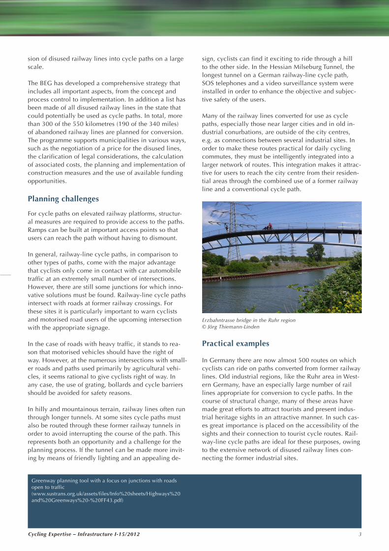
Erzbahntrasse bridge in the Ruhr region© Jörg Thiemann-Linden

Cycling Expertise – Infrastructure I-15/20124
ImprintPublisher: German Institute of Urban Affairs (Difu) gGmbHZimmerstraße 13–15, 10969 Berlin Department for Mobility and InfrastructureEditors: Jörg Thiemann-Linden, Tobias [email protected]
Conclusion
In Germany and Europe, there are countless disused railway lines that have yet to find a new purpose. As railway-line cycle paths, these structures can be put to good use while, at the same time, leaving political stakeholders and railway companies the possibility of re-establishing rail services at some point in the future. Railway-line cycle paths are especially attractive for tourist use, but they also have great potential for eve-ry-day use as gradient-free, direct routes with few in-tersections. However, the entire process, from the land reclassification and purchase to the structural conver-sion work, is relatively tedious and complex. There-fore, municipalities – particularly smaller ones – rely on support from experts and specialised organisations.
lies. For this project a ‘community of pur-pose’ (Zweckgemein-schaft) was formed, which has already succeeded in acquir-ing a large portion of the necessary fund-ing. In addition sev-eral special events have been organised, in which many vol-unteers have helped clear the overgrown railway line of bushes and scrub. If the pro-ject continues to go ahead as planned, the result will be a path that can be used by pedestrians, cyclists and skaters alike to reach their des-tinations in Wuppertal, comfortably and safely, over the rooftops of the city.
The nine-kilometre Erzbahntrasse cycle path extends be-tween the cities of Bochum and Gelsenkirchen, in the heart of the Ruhr region. This path, which rests atop the 15-metre-high (50-foot-high) platform of a former indus-trial railway line, leads past numerous industrial her-itage sights and structures. Coal mines, mining settle-ments and transport facilities typical for the Ruhr region can be seen along the path; which otherwise passes through a beautiful natural landscape and is one of the “green belts” that crisscross many parts of the densely populated Ruhr conurbation. The path leads over sever-al former railway bridges of historical interest. At both ends of the path, architecturally sophisticated bridge structures have been built to provide cyclists access to the railway platform. The Erzbahntrasse path is part of a more than 700-kilometre (435-mile) network of cycle routes spanning the industrial Ruhr region, mostly along former railway lines or straightened river channels and canals.
However, in the recent past, many railway-line cycle paths have also been created in rural regions of Ger-many; these paths are available to tourists for outings or longer tours. The Vulkanweg route winds its way through the state of Hesse for 94 kilometres (58 miles), almost entirely along the path of a former local rail-way line. On this route cyclists and skaters can traverse the highlands of the Vogelsberg Mountains without hav-ing to deal with steep gradients. An Internet portal offers comprehensive information about the cycle route and names several partner operations, such as restaurants, accommodations and bike-rental services. Furthermore, the route Vogelsbergradweg is part of the ’BahnRadweg Hessen’ route, which extends across the state with a to-tal length of 245 kilometres (152 miles).
A broad-based citizens’ movement in Wuppertal, North Rhine-Westphalia, is campaigning for a railway-line cy-cle path intended primarily for everyday cycling and foot traffic. The ‘Wuppertal Bewegung e.V.’ seeks to con-vert a 16-kilometre (10-mile) stretch of disused railway line that stretches over a chain of hills along the north-ern edge of the basin in which the city of Wuppertal
More information on Greenway Cycle Routes can be found inCyE I-12 Super Cycle Highways
“Cycling Expertise“ is available online: www.nrvp.de/en/transferstelle
Funded by
Postcard of an old Nordtrasse viaduct in a promotional ad for Wuppertal© Wolf Birke/knapp daneben