Embed Size (px)
DESCRIPTION
Forest roads and Alpine trails lead around the Kolmnock. The route starts out at the Harmony Hotel Kärntnerhof and leads on towards the Dragehütte and over the mountain ridge westwards to the Strohsack (1,904m). From here, the route leads along the South side down to the Wegerhütte and West from the Feldpannbach brook. Here the route leads around the mountain via Obertweng and along the Twengbach brook back to the start. For those who prefer a less strenuous route, take the Kaiserburg-Gondel cable car (free with the Kärnten Card). Map material: for more detailed information, see Nockbike map no. 8. Guiding: held 1 x per week at 2 ability levels (with biking technique training).
Citation preview
Mountainbiking
Cycling around the Kolmnock
1
Experience
Landscape
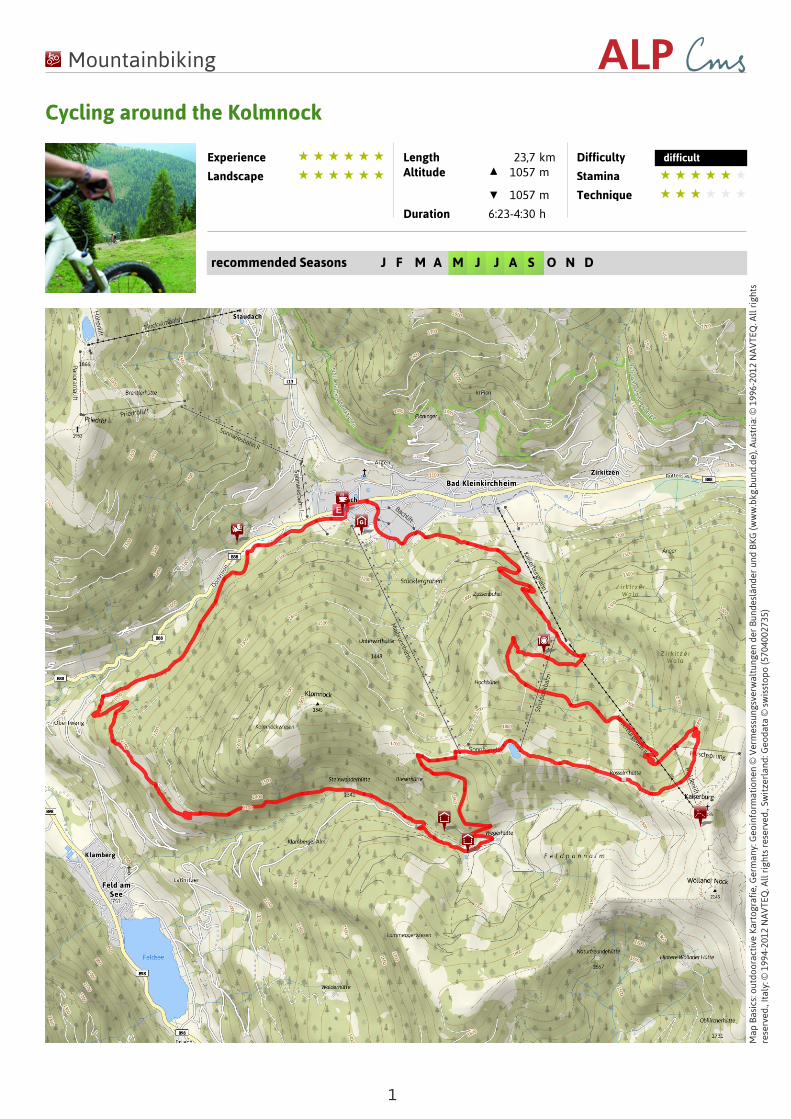
Length 23,7 kmAltitude 1057 m
1057 m
Duration 6:23-4:30 h
Difficulty difficult
Stamina
Technique
recommended Seasons J F M A M J J A S O N D
Map
Bas
ics:
out
door
acti
ve K
arto
graf
ie, G
erm
any:
Geo
info
rmat
ione
n ©
Ver
mes
sung
sver
wal
tung
en d
er B
unde
slän
der
und
BK
G (w
ww
.bkg
.bun
d.de
), A
ustr
ia: ©
199
6-20
12 N
AV
TEQ
. All
rig
hts
rese
rved
., It
aly:
© 1
994-
2012
NA
VTE
Q. A
ll r
ight
s re
serv
ed.,
Swit
zerl
and:
Geo
data
© s
wis
stop
o (5
7040
0273
5)
Mountainbiking
Cycling around the Kolmnock
2
Road surfaceUnknown 23.7
km
Description
Summary
DescriptionForest roads and Alpine trails lead around theKolmnock. The route starts out at the HarmonyHotel Kärntnerhof and leads on towards theDragehütte and over the mountain ridge westwardsto the Strohsack (1,904m). From here, the routeleads along the South side down to the Wegerhütteand West from the Feldpannbach brook. Here theroute leads around the mountain via Obertweng andalong the Twengbach brook back to the start. Forthose who prefer a less strenuous route, take theKaiserburg-Gondel cable car (free with the KärntenCard).
Map material: for more detailed information, seeNockbike map no. 8.Guiding: held 1 x per week at 2 ability levels (withbiking technique training).
Starting point of the tourTourism information of Bad Kleinkirchheim
Directions
LiteratureKompass Rad- und Mountainbikekarte KärntnerNockberge
Maps
Kompass Rad- und Mountainbikekarte KärntnerNockberge
ParkingÖffentlicher Parkplatz
Public transportBus
Further information/linkswww.badkleinkirchheim.atwww.nockbike.at
End point of the tourTourism information of Bad Kleinkirchheim
Properties
Nice views Tour routeWith refreshmentstops
Mountain railwayascent/descent
Points of Interest
Tipp
Bergrestaurant Waldtratte
Kleinkirchheim 1
9546 Bad Kleinkirchheim
0664/3251857 www.waldtratte.at
Tipp
Trattlers Einkehr
Teichstraße 7
9546 Bad Kleinkirchheim
+43 4240 8114 www.trattlers-einkehr.at
Mountainbiking
Cycling around the Kolmnock
3
Tipp
Konditorei Café RestaurantHutterBacher Weg 1
9546 Bad Kleinkirchheim
+43 4240 454 www.konditorei-hutter.at
Tipp
Kaiserburg
Rieserhütte
Klambergstraße 17
9544 Feld am See
+43 664 / 2530483
Klamerhütte & Sennerei
Klambergstraße 7
9544 Feld am See
+43 (676) 9256410
Buschenschank Hüblbauer
Untertscherner Weg 26
9546 Bad Kleinkirchheim
04240/337
Author and source
Author Christian Miklautsch
created 26.08.2010
changed 15.07.2013
Source Bad Kleinkirchheim Tourismus
Pictures
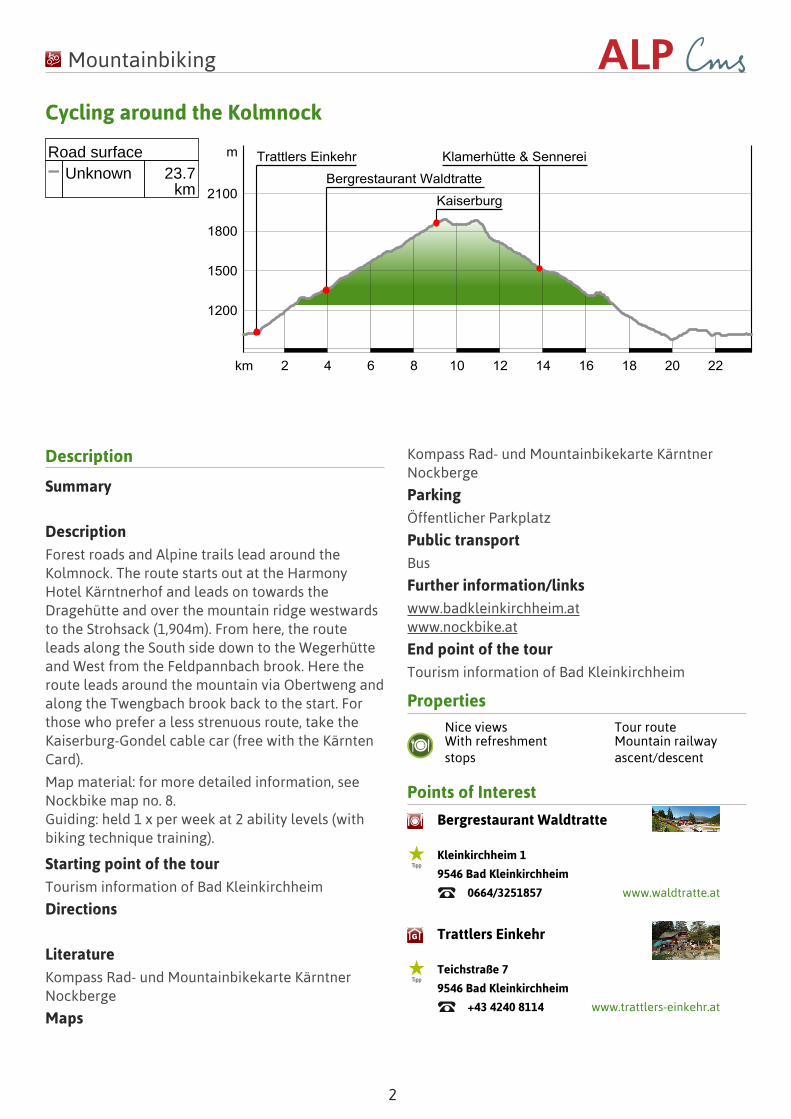
MountainbikenAuthor Bad Kleinkirchheim TourismusSource Bad Kleinkirchheim Tourismus
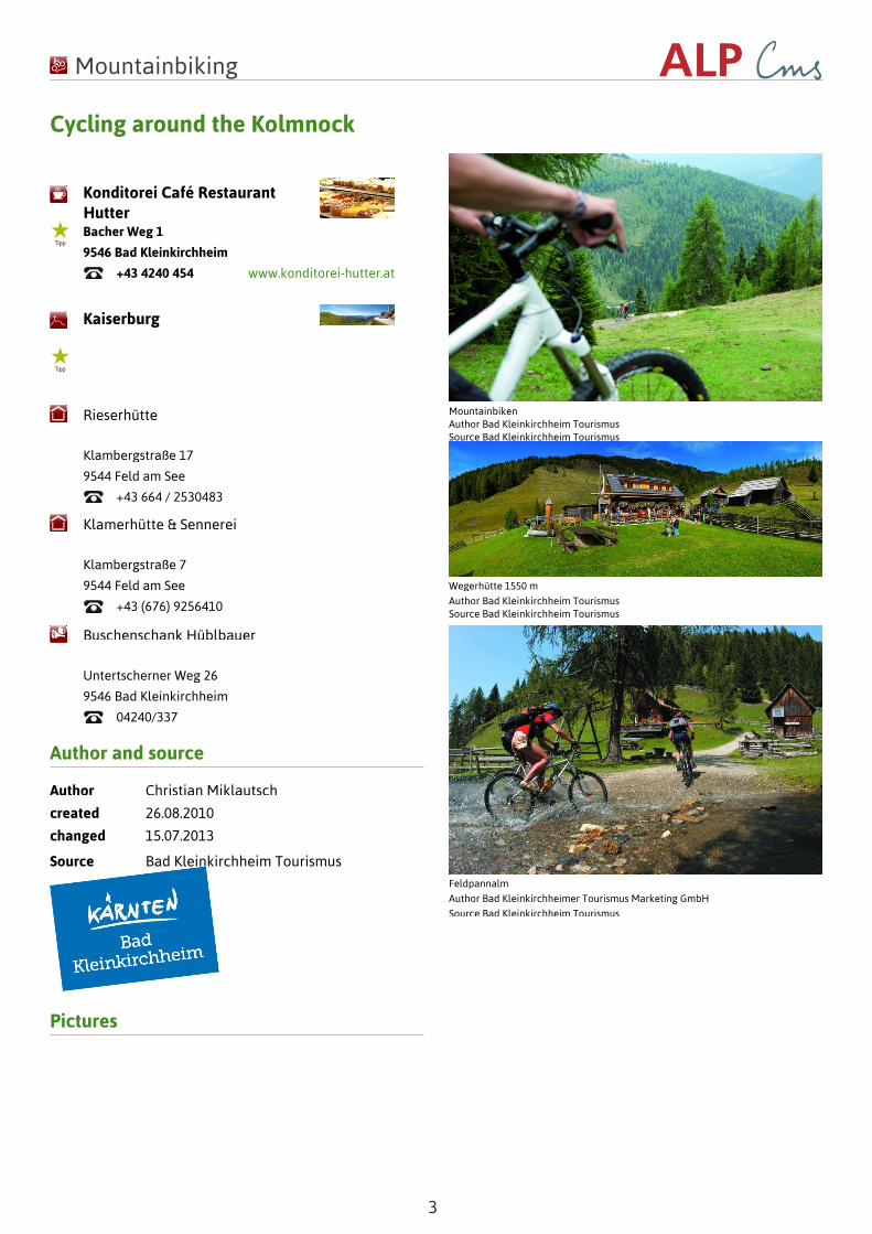
Wegerhütte 1550 m
Author Bad Kleinkirchheim TourismusSource Bad Kleinkirchheim Tourismus
Feldpannalm
Author Bad Kleinkirchheimer Tourismus Marketing GmbH
Source Bad Kleinkirchheim Tourismus
![[What is Acceptable Risk in Cycling Infrastructure?]conf.tac-atc.ca/english/resourcecentre/readingroom/... · 2018-02-13 · [What is Acceptable Risk in Cycling Infrastructure?] Forbes](https://img.pdfslide.us/doc/110x75/5ed4fc95f7d20c4b401f6c4e/what-is-acceptable-risk-in-cycling-infrastructureconftac-atccaenglishresourcecentrereadingroom.jpg)


![CYCLING TDF2011 Regulations (French + English)[1]](https://img.pdfslide.us/doc/110x75/577d28d51a28ab4e1ea5555f/cycling-tdf2011-regulations-french-english1.jpg)