Embed Size (px)
Citation preview

CYCLE NETWORK ANDROUTE PLANNING GUIDE


1
This document is the property of the Land Transport Safety Authority, New Zealand.
Reproduction in full or in part is permitted. Please acknowledge the LTSA.
© Land Transport Safety Authority, New Zealand, 2004
www.ltsa.govt.nz
ISBN 0-478-24172-0
CYCLE NETWORK AND ROUTE PLANNING GUIDE

2
STEERING GROUP
Tim Hughes (Project Manager) and Lyndon Hammond, LAND TRANSPORT SAFETY AUTHORITY
Gerard Burgess, TRANSFUND NEW ZEALAND
Ian Clark and David McGonigal, TRANSIT NEW ZEALAND
Michael Blyleven and Nick Bryan, ENVIRONMENT CANTERBURY
Michael Ferigo, CHRISTCHURCH CITY COUNCIL
Esther Sassenburg, NORTH SHORE CITY COUNCIL
Rachel Algar, MANUKAU CITY COUNCIL
Glen Koorey, CYCLING ADVOCATES NETWORK
Michele Gyde, CYCLE SAFE CHRISTCHURCH (SCHOOL CYCLE EDUCATION)
ACKNOWLEDGEMENTSThe following consultants contributed to the project:
Paul Ryan of Opus International Consultants, Hamilton, team leader, literature review and drafting.
Roger Boulter, Transport Consultant, Hamilton, literature review and drafting.
Kym Dorrestyn, Consultant, Adelaide, literature review and drafting.
Soeren Underlien Jensen, Atkins Global Consultants, Denmark, peer review.
3
CONTENTSGlossary of terms 4
Abbreviations 4
INTRODUCTION1 Introduction 6
THE PLANNING AND POLICY CONTEXT2 The planning and policy context 10
THE PRINCIPLES OF CYCLE NETWORK PLANNING3 Cyclists’ needs 14
4 Possible cycle route locations 24
5 Possible cycle network approaches 30
6 Possible cycle route components 34
THE CYCLE NETWORK PLANNING PROCESS7 Assessing cycle demand 48
8 Identifying cycle route options 56
9 Evaluating cycle route options 58
10 The cycle network plan 66
11 Prioritisation 68
12 Implementation 72
13 Monitoring 76
14 Consultation 78
APPENDICESAppendix 1: Cycling strategic plans 80
Appendix 2: Scaling cycle counts 81
Appendix 3: Sample questionnaire 84
Appendix 4: Bibliography 86

4
BUS LANEA bus lane that cyclists can also use.
CONTRA-FLOW LANE
A lane that permits cyclists to ride against traffi c in a one-way street.
CYCLEA vehicle with two or more wheels and pedals that is propelled mainly by the muscular effort of the rider. It includes bicycles, tricycles and power-assisted cycles with no more than 200 watts total auxiliary power.
CYCLE ADVISORY GROUPA group of stakeholder representatives that advises on improving cycling conditions.
CYCLE FACILITYInfrastructure that is cycling-specifi c, such as cycle lanes, paths and parking.
CYCLE LANEA lane marked on a road with a cycle symbol, which can only be used by cyclists.
CYCLE NETWORK PLANA map of the primary cycle route network (see defi nition below) and a schedule of the cycle infrastructure projects required to develop it.
CYCLE PATHAn off-road path for cycles. It can be an exclusive cycle path, a shared-use path or a separated path (see defi nitions below).
CYCLE PROVISIONThe provision of satisfactory conditions for cycling, whether or not there are specifi c cycle facilities.
CYCLING PLANNER / CHAMPIONA road controlling authority employee who is responsible for the day-to-day planning and implementation of cycle provision in the authority’s area.
CYCLING POLICYA general course of action relating to cycling to be adopted by the government or an organisation.
CYCLING SAFETY AUDITA formal process to identify factors that could either increase the risk of crashes involving cyclists, or increase the severity of cyclists’ injuries in a crash.
CYCLING STRATEGIC PLANA document setting out cycling objectives and the actions required to achieve them including a cycle network plan.
DESIRE LINEA straight line between the origin and destination of a potential cycle trip.
EXCLUSIVE CYCLE PATHA path that can be used legally only by cyclists.
GRADE SEPARATIONThe vertical separation of cyclists by a bridge or underpass across a roadway, railway line etc. It contrasts with an at-grade intersection or level crossing.
HOOK TURNA right turn a cyclist makes at traffi c signals, where they keep left while proceeding straight through the intersection, wait at the far left side for the lights to change, then cross with the side road traffi c.
LEISURE CYCLINGCycling done just for the journey itself, not to get to an activity at the journey’s end. Sports and recreation cyclists and cycle tourists do leisure cycling.
LEVEL OF SERVICEThe quality measure of how well conditions provide for road users. For motor traffi c it mainly assesses interruptions to free traffi c fl ow. For cycling, other factors seem to be more important such as perceived safety, comfort, and directness of route. Refer to section 9.5
PRIMARY CYCLE NETWORKThe most used cycle facilities, designed mainly for trips across town and between suburbs.
SEPARATED PATHA path where the section for cyclists’ use is separated from the section for pedestrians’ use.
SHARED-USE PATHA path provided for use by both cyclists and pedestrians.
TRAFFIC CALMINGA combination of measures (mostly changes to the road environment) aimed at altering driver behaviour (such as by reducing speed) and improving conditions for pedestrians, cyclists and residents.
TRANSIT LANEA lane which can only be used by public passenger vehicles, motor cycles, cycles and motor vehicles carrying a specifi ed minimum number of passengers.
UTILITY CYCLINGCycling done mainly to get to an activity at the journey’s end, such as commuting trips to work, education or shops.
BCI
Bicycle compatibility index
CDS
(Cycle design supplement). New Zealand
supplement to Austroads Guide to traffi c
engineering practice: Part 14: Bicycles.
(Transit New Zealand, 2004)
EECA
Energy Effi ciency and Conservation Authority
LOS
Level of service (see glossary)
LTCCP
Long term council community plans
LTSA
Land Transport Safety Authority
RCA
Road controlling authority
RLTC
Regional land transport committee
RLTS
Regional land transport strategy
SPARC
Sport and Recreation New Zealand
GLOSSARY OF TERMS
ABBREVIATIONS

CHAPTER 1 INTRODUCTION
• Purpose
• Scope
• Guide outline
What provisions should be made for cyclists, and where?
This guide aims to promote a consistent approach to planning the provision for cycling in New Zealand.
INTRODUCTION
6
1.1 Cycle network planningCycle network planning is a process of improving community mobility by providing interconnected routes and facilities based on bicycle users’ needs (Bach and Diepens,
2000). It aims to provide cyclists with safe, comfortable, direct routes from all origins to all destinations that:
• link to form a network• retain existing cyclists• encourage more people to cycle.
1.2 Cycle route planningCycle route planning is the organisation of the most appropriate facilities and treatments into a continuous path for cyclists that will take them safely and comfortably for the greater part of their journey (Bach and Diepens, 2000). Facilities will differ depending on the environment through which the route passes, and different types of cyclists will need different types of cycle route (Dorrestyn, 1996).
Cycle route planning aims to provide cycle routes that:• provide the highest level of service
(LOS) for cyclists, including safety, convenience and comfort
• provide operating space to cycle and other users
• minimise confl icts with other users.
(Cumming, Barber, Smithers, 1999; Jensen et al, 2000; Scottish Executive, 1999).
1.3 PurposeThis guide aims to promote a consistent, world’s best practice approach to cycle network and route planning throughout New Zealand. It sets out a process for deciding what cycle provision, if any, is desirable and where it is needed.
The guide is intended to help people involved in cycle planning to develop cycle networks that contribute to the outcomes required by the New Zealand
Transport Strategy and the national walking and cycling strategy. It will also help people preparing regional and local cycling strategies.
1.4 Scope of guideThe guide covers all aspects of cycle network and route planning, with a focus
on the role and importance of cycle infrastructure in cycling strategic plans, and on planning for cycling for transport.
It expands on chapter 2 of the Guide to
traffi c engineering practice: Part 14: Bicycles (Austroads, 1999) and complements the New Zealand supplement to that guide (CDS) (Transit New Zealand 2004).
The cycle planning approaches and interventions adopted will depend on the circumstances at each location. With this in mind, the guide does not prescribe a single approach or intervention, but presents a variety, along with their advantages, disadvantages and limitations and the circumstances when each would be most appropriate. It recognises that fi nancial, technical and political factors may affect what can be achieved at any particular location or time.
This is not an instruction manual, or a guide for cycling facility design, planning a mountain bike network or preparing cycling strategies. It is a best practice guide to the process of cycle network planning, with tools that may help cycle planners and communities. It does not have the force of law.
1.5 MethodologyThe project to develop this guide was managed by the Land Transport Safety Authority (LTSA), as one of the Road Safety
to 2010 strategy projects. Consultants were employed to develop the drafts. A stakeholder steering group (see page 2) guided its development and gave feedback on the various drafts.
The guide’s content was informed by a review of international literature on cycle network and route planning. A separate report on this is available on the LTSA website at www.ltsa.govt.nz (Opus, 2003).
A draft of the guide was released for public submissions before the New Zealand Cycling Conference 2003.
After the fi nal draft was received from the consultants an international expert peer review was performed. The LTSA carried out some fi nal edits.
1.6 Future revisionThe guide will be updated as cycle network and route planning knowledge and practice develops. Priorities for research have been developed. The LTSA has already started a project on New Zealand-appropriate methods for assessing the LOS provided for cyclists, while assessing the latent demand for cycling is another area that needs more work.
1.7 Guide and process outlineFigure 1.1 (see opposite) provides an outline of the guide’s three main sections: • The planning and policy context.• The principles of cycle network planning.• The cycle network planning process.
1.8 Safer RoutesThe development of the Safer Routes programme is another LTSA Road Safety to
2010 strategy project. Safer Routes applies many of the tools in this guide at a location identifi ed by the community to be a high risk for cyclists (and/or pedestrians). It then develops and implements an integrated package of engineering, enforcement and educational interventions to address locally identifi ed risk factors.
The LTSA is currently trialling Safer Routes in a number of territorial local authorities, and developing guidelines for safe routes facilitators. As part of the ongoing Safer Routes programme LTSA can assist with the funding of facilitators and provision of exert advice. For more information on Safer Routes contact your regional LTSA offi ce.
1 INTRODUCTION
It is a best practice guide to the process of cycle network planning, with tools that may help cycle planners and communities.

7
Figure 1.1: Outline of the guide and the cycle network and route planning process
CONTEXT Establish the planning and policy context (Ch.2)What is the environment for planning cycle networks?
Cyclists’ needs (Ch.3)What are the different types of cyclist trips and for what skill level
are we designing?
Possible locations for cycle routes (Ch.4)Where can cycle routes be developed?
Possible cycle network approaches (Ch.5)What broad approach could be taken to cycle
network development?
Possible cycle route components (Ch.6)What types of cycle provision or facility can be used to develop
a cycle route?
Assess cycle demand (Ch.7)How many cyclists of what types now ride or wish to
ride and where?
Consult on cycle network development (Ch.14)
Does the network
meet the needs of
all stakeholders?
Identify possible cycle routes and provision (Ch.8)Which routes could be developed for cyclists and what types of
cycle provision do they need?
Evaluate cycle route options (Ch.9)How good are existing and potential cycle routes?
Develop the cycle network plan (Ch.10)What network is desired for cyclists?
Prioritise cycle route implementation (Ch.11)Which cycle routes should be done fi rst?
Implement cycle network development (Ch.12)How should cycle routes be implemented?
Monitor cycle network development (Ch.13)Is the cycle network achieving its aims?
PRINCIPLES
PROCESS
APPENDICESCycling strategic plans (Appendix 1)
Scaling cycle counts (Appendix 2)
Sample questionnaire (Appendix 3)
Bibliography (Appendix 4)

8

CHAPTER 2 THE PLANNING AND POLICY CONTEXT
• Law, guidelines, strategies
• National and regional transport strategies
• Local authority responsibilities
• Cycling strategic plans — why, what, how?
Cycle network and route planning takes part within
a legal, transport, social and administrative context
— and can’t take place in isolation from it.
Those planning for cycling need to understand transport and the law affecting it, plus the variety of government roles, policies and strategies at national, regional and local levels.
This section outlines this larger context, and then discusses cycling strategic plans — why we have them, what they should contain, and how they fi t with the bigger picture. Cycle network and route planning is only one part, alongside others, of preparing a cycling strategic plan.
THE PLANNING AND POLICY CONTEXT

10
2.1 Cycling as transportAt its most essential, cycling is a means of transport, and in this respect is no different from the car. In both cases, about three-quarters of trips are for utility (practical, day-to-day) purposes, and one-quarter for leisure (New Zealand Travel Survey, LTSA 2000), with signifi cant variations by location and ages of road users.
Most journeys are short. About two-thirds of all vehicle trips are less than six km (LTSA, 2000), which is an easy cycle ride for most people. Cycling’s travel range can be extended by cycle carriage on buses and trains, or secure parking at stations.
Cycling can potentially take place from all origins to all destinations, and is not restricted to a small number of routes.
2.2 Transport and the lawLaw includes not only Acts of Parliament, but also common law, which is understood and accepted by everyone and defi ned by law court judgements.
Common law includes everyone’s duty to care for their own safety and to avoid causing harm to others. For example, in a crash we need to establish not only who should have given way, but also whether those involved were trying to avoid danger to themselves and others.
Under common law everyone has the right to travel unimpeded along all public roads, except where legal restrictions have been imposed (for example, prohibiting walkers and cyclists from using motorways). Road controlling authorities (RCAs) are obliged to safeguard this right for all lawful road users, including cyclists.
Legislation includes Acts of Parliament, as well as Rules and Regulations made by people or organisations to whom Parliament has delegated this power (for example, the Minister of Transport for Land Transport Rules). The main laws relating to cycling are found in the Traffi c Regulations, which are currently being converted to the Road user rule and the Traffi c control
devices rule. In these rules, cyclists are regarded as drivers of vehicles and their obligations are in most respects the same as those of motor vehicle drivers. There are also relevant rules on the use of land under the Resource Management Act 1991 in regional and district plans.
2.2.1 Bylaw powers
Local authorities and road controlling authorities have power to enact bylaws for areas within their responsibility. Bylaws can cover activities on the road (for example one-way traffi c and contra-fl ow cycle movement, speed limits, parking, and restrictions on cyclists’ use of some roadways) and off the road (for example restrictions on cycling within parks and reserves).
2.3 GuidelinesGuideline documents do not have force of law, but are recognised as best practice when adopted by legally responsible bodies, such as RCAs or other government agencies. This publication is a guideline. The offi cial New Zealand guide to road and path design is Austroads Guide to traffi c engineering practice: Part 14: Bicycles (1999). Transit New Zealand has prepared a cycle design supplement (CDS), which is the offi cial guide to its application in New Zealand. Also relevant is the New Zealand Manual of traffi c signs and markings, Parts 1
and 2 (Transit New Zealand/LTSA 1998 and 2004).
2.4 National transport strategiesThe New Zealand Transport Strategy (2002) contains the government’s position on transport. Its overall vision is: By 2010 New Zealand will have an affordable, integrated, safe, responsive and sustainable transport system.
2 THE PLANNING AND POLICY CONTEXT
By 2010 New Zealand will have an affordable, integrated, safe, responsive and sustainable transport system.

11
Broader objectives include:
• creating an integrated mix of transport modes
• protecting and promoting public health• assisting safety and personal security • enhancing economic, social and
environmental wellbeing• ensuring environmental sustainability• improving access and mobility, including
walking and cycling.
Promoting walking and cycling is recognised as one of fi ve priority areas because of its contribution to the strategy’s vision and objectives. This priority is now enshrined in the Land Transport Management Act 2003, so Transfund New Zealand now funds the promotion of walking and cycling in a separate output class.
2.4.1 National walking and cycling strategy
The draft walking and cycling strategy Getting there — on foot, by cycle
(October 2003, expected to be fi nalised during 2004) provides more details. It articulates a vision of: A New Zealand where people from all sectors of the community choose to walk and cycle for transport and enjoyment — helping ensure a healthier population, more lively and connected communities, and a more affordable, integrated, safe, responsive and sustainable transport system.
It sets out a wide range of actions that would make cycling a more attractive mode of travel. Priorities relevant to cycle planning include:• expand our knowledge and skill base
to address walking and cycling• encourage planning, development and
design that support walking and cycling• provide supportive environments
for walking and cycling in existing communities
• improve networks for long-distance cycling
• address crime and personal security concerns around walking and cycling
• improve road safety for pedestrians and cyclists.
The LTSA is preparing a Pedestrian and
cyclist safety framework, which addresses safety issues.
2.5 Regional land transport strategiesEach regional council is required to develop a regional land transport strategy (RLTS) with help from a regional land transport committee (RLTC). RLTCs are required by law to represent a range of road users, and some now include cycling representatives.
Although regional councils do not directly manage the roads, all projects in their regions must take RLTSs into account. RLTSs also carry weight in Transfund New Zealand’s decisions on funding RCA projects and packages.
Some regional councils have supplemented their RLTS with a regional cycling strategy.
2.6 Road controlling authoritiesRCAs have direct responsibility for the road system. They usually own the roads and public paths, and (often through contractors) construct, improve and maintain them. RCAs have powers to regulate road users’ behaviour, for example by banning parking, creating one-way streets and installing traffi c signals.
As well as being a local authority, every city and district council is an RCA and Transit New Zealand is the RCA for state highways. In some areas local authorities manage state highways on Transit New Zealand’s behalf (for example, Rotorua and Marlborough).
2.7 Other local council responsibilitiesLocal councils have other roles, besides that of RCA, that affect transport and cycling.
2.7.1 Resource Management Act 1991
Under the Resource Management Act 1991, councils prepare district plans and regional councils regional plans. Both types of plan include rules regulating what may or may not happen.
2.7.2 Reserves Act 1977
Under the Reserves Act 1977, local councils are responsible for managing various types of reserve land.
Off-road cycle paths are often located on recreation reserves. Councils may allow for these in their relevant reserve management plans.
2.7.3 Local Government Act 2002
The main Act governing local councils’ activities is the Local Government Act 2002, which includes the power to declare a path a cycle track. Under the Act, councils prepare and consult on annual plans setting out proposed spending during the coming year, and long term council community plans (LTCCPs) outlining spending over the forthcoming 10 years. The public submission processes of these plans may be used to argue for spending on provision for cyclists.
2.8 Integrated transport planningIntegrated transport planning aims to embrace a range of perspectives traditionally covered separately, including:• a variety of forms of transport
(for example car, bus/rail, cycling and walking)
• the relationships between transport and land use
• the contribution transport makes to other economic, social, health and environmental objectives.
This type of planning may become more signifi cant in light of Transfund New Zealand’s Allocation Process Review (2003/2004) which encourages integrated proposals. Cycling should be integrated into all transport planning.
2.9 Other government strategiesActions to promote cycling are implied under other strategies as well, such as those covering energy effi ciency, urban design and form, preventive health and environmental protection. Non-transport agencies such as the Energy Effi ciency and Conservation Authority (EECA) and Sport and Recreation New Zealand (SPARC) have sometimes taken the lead in signifi cant cycling promotion initiatives. These include EECA’s support for school travel plans, projects and organisations, and SPARC’s cycle-friendly employer schemes.
A New Zealand where people from all sectors of the community choose to walk and cycle for transport and enjoyment — helping ensure a healthier population, more lively and connected communities, and a more affordable, integrated, safe, responsive and sustainable transport system.

12
New Zealand Transport Strategy
National Walking and Cycling Strategy
Regional cycling strategy
Local cycling strategic plans
Implementation of cycling strategic plans at a local level
2.10 Cycling strategic plansCycling strategic plans need to address engineering, education, enforcement and encouragement — the four Es (Geelong Bike Plan
Study Steering Committee, 1977). This guide focuses on planning for the engineering element of cycling strategic plans.
Appendix 1 provides guidelines on matters recommended for inclusion in cycling strategic plans. Funding is available from Transfund New Zealand for their preparation.
Typically, cycling strategic plans aim to increase the number of cycle trips while
reducing cyclist injuries. This appears to be realistic as many cities in the world have achieved it, for example York in the United Kingdom and Portland in the United States. Because traffi c dangers deter cycling, improving cycle safety is an essential part of cycle promotion. There is evidence that higher cycling numbers result in a lower crash risk (Jacobsen, 2003).
Reducing traffi c volumes and speeds may do more to improve cyclist safety than providing cycling facilities, depending on the circumstances (Institution of Highways and
Transportation et al, 1996). Consequently, a cycling strategic plan needs the support of more general traffi c and transport strategies(Koorey, 2003).
The quality of provision for cyclists will refl ect the commitment to increasing cycling’s share of total journeys. Lower quality facilities require more skill to negotiate and may not attract new, less confi dent cyclists.
2.11 Document hierarchyFigure 2.1 shows how cycling strategies at regional and local levels relate to some of the other policy and strategy documents referred to in this section.
Cycle design supplement
Pedestrian and cyclist safety framework
Cycle network and route
planning guide
Regional Land Transport Strategy
Mass cycle rides can be a signifi cant encouragement element for a cycling strategy. (Photo: Roger Boulter)
Figure 2.1: Document hierarchy

A network contains many types of facilities, and
the cyclists using it vary in age and cycling skills.
Different cyclists have different needs and prefer
different types of facilities. Before deciding what
provision should be made for cyclists, it is necessary
to understand clearly what cyclists need.
Should cycle facilities be provided on-road or off-road? Should they be provided on urban arterial roads, or should these roads be avoided? What provisions should be made for cycling in rural areas?
This part of the guide describes and discusses alternative approaches to network planning and
the array of cycle facilities available.
CHAPTER 3 CYCLISTS’ NEEDS
• Cyclists’ skill levels trip types and requirements
CHAPTER 4 POSSIBLE CYCLE ROUTE LOCATIONS
• Main roads, back streets, reserves, railways, public transport
CHAPTER 5 POSSIBLE CYCLE NETWORK APPROACHES
• Roads or paths, dual networks, hierarchies, new and existing areas
CHAPTER 6 POSSIBLE CYCLE ROUTE COMPONENTS
• Lanes, shoulders, bus/transit lanes, mixed traffi c, paths, intersections.
PRINCIPLES OF CYCLE NETWORK PLANNING
THE

14
3.2 The purpose of cyclingCycling generally has two main purposes:• utility• leisure.
Utility cycling involves making a journey for the main purpose of doing an activity at the journey’s end, such as work, education or shopping. Time is often an important consideration.
Leisure cycling is done for the journey itself. Leisure cyclists include sports training cyclists, recreation riders and cycle tourists. They also include children playing on their bikes near their homes.
3.3 Cyclists’ skill levelsFor the purpose of planning, cyclists may be grouped into three skill levels:• child/novice• basic competence• experienced.
3.3.1 Child/novice
These are children and beginner adults. Depending on their age, children have serious knowledge, perceptual and cognitive limitations in relation to roads (Crossing, 1987). They can be unpredictable, do not have a good appreciation of road hazards and are generally unfamiliar with road rules. However, children as young as eight do not pose as high a risk as adolescents as they have a reduced tendency for deliberate risk-taking behaviours.
3 CYCLISTS’ NEEDS3.1 IntroductionSatisfying cyclists’ needs and providing a high level of service (LOS) for cyclists are vital to maximising cycling. These needs vary according to cyclists’ skill levels and their trip purposes. One type of cycle provision may not suit all cyclists using a particular part of the cycle network. This chapter discusses:
• the purpose of cycling
• cyclists’ skill levels
• general route requirements
• cyclists’ trip types and their preferred route characteristics
• complementary facilities.
Novice cyclist, Oriental Parade, Wellington, New Zealand. (Photo: Juliet Rama)
Cycling for recreation on rural road shoulder, Prestons Road, Christchurch, New Zealand. (Photo: Tim Hughes)

15
Intermediate school-aged cyclist, Christchurch, New Zealand. (Photo: Tim Hughes)
These cyclists most commonly ride to school and shops and for recreation near their homes. This local environment should be safe for them. They cannot safely interact with traffi c apart from on traffi c-calmed neighbourhood roads. They prefer full separation from other traffi c if travelling along busier roads and grade separation or traffi c signals for crossing them.
Cycling strategic plans can aim to provide on-road training for novices who have reached about 10 years of age. A good example is the CycleSafe Team at Christchurch City Council.
Similar training for novice adults is also benefi cial.
3.3.2 Basic competence
Cyclists can achieve basic competence at about 10 years of age with appropriate training. Their utility trips generally extend further to intermediate and high schools.
These cyclists can ride on quiet two-lane roads, manoeuvre past parked cars, and merge across and turn right from beside the centreline. They can cope with simple traffi c signals and single-lane roundabouts that are well designed to slow through traffi c. On busier roads they prefer cycle lanes and facilities at junctions. They are not equipped to interact with faster traffi c, multi-lane roads and multi-lane roundabouts. They usually lack the confi dence to defend a lane in narrow situations.
Cycling strategic plans should consider whether it is practical to design all local facilities so they are suitable for cyclists of basic competence. If not, more advanced training from about age 13 could be benefi cial.
3.3.3 Experienced
These cyclists have usually learnt by long experience how best to interact assertively with traffi c .
They typically make longer commuting trips, sports training rides and cycle touring journeys. They do not require specifi c cycle facilities, just enough room for faster/busier situations. They will defend a lane where there is not enough room, judge the merge across faster multi-lane traffi c, use multi-lane roundabouts in most cases (though apprehensively), and will not usually divert to a cycle path.
Children receiving cycle training, Wellington, New Zealand. (Photo: Maria Cunningham)
Experienced cyclist, Oriental Parade, Wellington, New Zealand. (Photo: Juliet Rama)

16
3.4 General route requirementsCyclists’ routes should provide: • safety• comfort• directness• coherence• attractiveness.
3.4.1 Safety
Cycle routes should be safe, provide personal security, and limit confl ict between cyclists and others.
Traffi c speed and volume affect cyclists’ safety. As these increase, it may be more desirable to separate cyclists from motorists. Safe provision at intersections is crucial.
Public lighting and other features that improve personal safety are also crucial.
Cyclists should always have available a convenient route that provides a high level of personal safety. Routes used at night should have lighting.
Cyclists’ perceptions of safety are important. Appropriate infrastructure standards and design will help cyclists feel more secure.
3.4.2 Comfort
Cycling routes should be smooth, non-slip, well maintained and free of debris, have gentle slopes, and be designed to avoid complicated manoeuvres.
Rain and wind discourage cycling. Measures to reduce their effects and make cycling more enjoyable include:
• considering walls, embankments or suitable hedges next to paths, but being aware of maintaining public surveillance
• paying attention to exposed paths near foreshores or ridges
• providing shelter at critical destinations.(Bach, 1992).
Safety — traffi c slowed where cycle path crosses minor road — Nelson, New Zealand. (Photo: Tim Hughes)
Comfort — path with good surface, some shielding from weather and no motor traffi c, Christchurch, New Zealand. (Photo: Kym Dorrestyn)

17
3.4.3 Directness
Cycle routes should be direct, based on desire lines, and result in minimal delays door to door. Parking facilities should be in convenient locations.
Indirect cycle routes or excessive delays may lead cyclists to choose more direct routes with greater risk. Some cyclists are unlikely to divert to safer routes greater than 10 percent extra in length (Hudson, 1982).
3.4.4 Coherence
Cycle routes should be continuous and recognisable, link all potential origins and destinations, and offer a consistent standard of protection throughout.
To be recognisable, cycling routes should use consistent standards and design.
Directness — Cycle bridge over major arterial road, Auckland, New Zealand. (Photo: David Croft)
Coherence — Separate cycle path becomes cycle lane to continue through signals, Delft, The Netherlands. (Photo: Tim Hughes)
Attractiveness — Shared roadway along canal, Delft, The Netherlands. (Photo: Tim Hughes)
3.4.5 Attractiveness
Cycle routes should integrate with and complement their surroundings, enhance public security, look attractive and contribute in a positive way to a pleasant cycling experience.

18
3.5 Cyclists’ trip types and requirements
For the purposes of cycle planning, cyclist trip types can be grouped into:
neighbourhood cycling
commuter cycling
sports adults
recreation cycling
touring cycling.
3.5.1 Neighbourhood cycling
Most neighbourhood cycling involves trips to local schools and shops, and children playing on their bikes. Cyclist provision should therefore be based mostly around the needs of novices.
Speeds are typically lower than 15 km/h. However, busy roads and short lengths of the primary cycle network may still need to be crossed to get to local destinations, and many potential destinations are along well traffi cked arterial roads.
The highest priority is ensuring a safe environment for children and novices in their local streets and around shops and schools.
These cyclists prefer:• the highest degree of safety• comfort and personal security • low traffi c speeds and traffi c volumes• a good separation from traffi c when local destinations require them to travel busy roads • minimal gradients • facilities for crossing busy roads, such as traffi c signals• secure parking at destinations• good lighting for evening trips• screening from weather and wind integrated with the surrounding landscape design.
3.5.2 Commuter cycling
Most commuter trips are done by high school students or adults commuting to work and tertiary education. However, for the purpose of this guide they include any longer-distance utility trip.
For most of their length these trips are on arterial roads or other primary cycle routes. Regular commuters generally ride at speeds of 20 to 30 km/h. The New Zealand Travel
Survey 1997/98 (LTSA, 2000) indicates the median trip length for commuting cyclists is about fi ve km. Most will choose a faster route at the expense of higher perceived safety, comfort and attractiveness. They are the main users of the primary cycle network.
It is important to note that designs based on ensuring the repeat business of current, more experienced commuters may not attract new users with less confi dence. As far as practical, across-town cycle facilities should cater for cyclists of basic competence, while maintaining the qualities valued by more experienced commuters.

19
These cyclists prefer:• high-quality road surfaces• direct and coherent routes• minimal delays• facilities that give them their own space• intersections that minimise confl icts with other traffi c• good lighting for evening trips • secure parking at or very close to destinations• facilities for changing clothes, lockers and showers.
3.5.3 Sports adults
Sports adults often travel at speeds higher than 30 km/h. They are confi dent cyclists and prepared to claim their road space. They generally cycle over long distances, mainly along urban arterial or rural roads, and may seek challenging
terrain. They often travel in groups of two or more and like to ride two abreast.
These cyclists prefer:• high-quality road surfaces• minimal delays• physically challenging routes and demanding gradients• generous road widths.
3.5.4 Recreation cycling
Recreation cyclists ride mainly for leisure and place a high value on enjoying the experience. They are usually less constrained by time and vary widely in skill and experience.
Popular recreation cycling destinations include routes along rivers, coasts and reserves, as well as attractive routes with low traffi c volume and speed.
These cyclists prefer:• comfort• good surfaces • minimal gradients• a high degree of safety and personal security • routes that are pleasant, attractive and interesting• screening from weather and wind• parking facilities where they dismount to use facilities or visit attractions
on the journey.
3.5.5 Touring cycling
Touring cyclists travel long distances carrying camping gear and provisions. They are often experienced and travel in pairs or groups.
These cyclists prefer:• routes that are, or lead to, pleasant, attractive and interesting locations• generous roadside shoulders• high-quality road surfaces, although some may seek journeys on lightly traffi cked
back roads.
• rest areas — water, toilets, shelter.

20
3.6 Complementary facilities3.6.1 General
Cycling planning needs to consider the whole journey. All cyclists need to store or park their bicycles securely. For other than short local trips, they may need to change clothes, have a shower and store items. For longer recreational journeys toilets, clean water and attractive resting places are important.
Such facilities will often benefi t people other than cyclists. For example, rest areas could benefi t motorists and pedestrians, and changing areas, lockers and showers at a workplace could benefi t lunchtime joggers.
3.6.2 Secure bicycle parking
All journeys require secure parking at each end. Most people will not cycle if they cannot secure their bicycle at their destination or public transport terminal (or take the bike with them on public transport).
The type of parking will depend on the need for security and convenience. The most common is the ability to lock cycles to a cycle stand. Older cycle-parking stands that support the bicycle by one wheel offer inadequate security and weather protection, and can easily cause wheel damage.
Choice of parking facility Three types of cycle parking are recommended: • stands• enclosures• lockers.
StandsStands are short-term parking devices that can be located in almost any position. They are suitable outside shops where there is a high degree of passive security. The frame and wheels of the cycle are locked to the rail.
Cycle stands — Christchurch, New Zealand. (Photo: Neil Macbeth)

21
EnclosuresEnclosures are a communal compound, generally at workplaces, where there may be a large number of cyclists.
As a longer-term parking option often located away from the public eye, enclosures should be protected from the weather and have a high degree of security and an appropriate form of access control. Swipe cards are often used for access. Within the compound, stands are generally installed to control internal parking and provide additional security. It is sometimes appropriate to require users to sign a contract to ensure they understand their obligations.
Bike lockersBike lockers are for individual cycles and are used where the highest security level is needed. They are mostly used for long-term parking.
Lockers are sometimes provided at public transport interchanges. As with enclosures, there are numerous access control choices, including coin-operated locks. Lockers can also be used to store cycling equipment such as helmets and other personal items.
3.6.3 Other end-of-trip facilities
Some situations require a conveniently located clothing change area.
For example, cyclists travelling distances more than 5 to 10 km often wear cycling clothes to cope with the build-up of body heat and perspiration and the need to move freely while cycling (although whether they need to change depends on the trip’s purpose and the destination activity, for example if it involves wearing formal clothing). In wet weather, cyclists travelling any distance may need protective clothing.
Baggage lockers are also needed at workplaces and transport interchanges, as modern cycles have numerous detachable items such as seats, lights and pannier bags but no lockable space in which to store them. Cyclists also appreciate clothes-drying facilities or places to hang wet clothes and towels to dry.
Showers can also be important. It has been determined that more than 80 percent of cyclists who commute to a central business district, and travel more than 10 km, require shower facilities (Adelaide,
Australia. Dorrestyn, 1995).
Hi-tech secure enclosure, Odense, Denmark. (Photo: Tim Hughes)
Bike lockers, Bielefeld City Council, Germany. (Photo: Tim Hughes)
Changing room with showers and lockers, Henry Deane building, Sydney, Australia. (Photo: Tim Hughes)

22
3.6.4 Trip facilities
Recreation and touring cyclists often undertake long trips and consequently have special requirements.
Urban recreation cyclists using reserves and similar resting places need drink fountains and toilets, typically at fi ve km intervals.
Touring cyclists need rest areas at about two-hour (30 to 40 km) intervals. These should include water supply points, shelter from the weather, tables and toilets. They also need access to shops for provisions, and to phones in emergencies. Such facilities will often be available in towns along routes.
Good examples of remote rural rest areas include Kawatiri Junction between Nelson and Westport, and Lyell in the Buller Gorge. Rural townships are ideal locations for rest areas.
3.7 SummaryTable 3.1 summarises the relevance of cyclists’ needs to cycle planning. It is necessarily broad and subjective, and individual cyclists will vary. Interpret the table with caution, and use your own judgement.
Rest area with toilets, water and shelter, Waiau township, North Canterbury, New Zealand. (Photo: Tim Hughes)

23
CYCLIST TYPE NEIGHBOURHOOD COMMUTING SPORTS RECREATION TOURING
Cyclists’ possible cycling objectives
To shops, school, or riding near home
To get to their destination effi ciently
To be physically challenged
To enjoy themselves and get some exercise
To see and enjoy new places and experiences
NETWORK/ROUTE REQUIREMENTS
CRITERIA
Safety Personal security (good lighting etc) 5 5 5 5 5 5 5 5 5 5 5 5 5 5 5 5 5 5 5 5 5 5
High degree of safety5 5 5 5 5 5 5 5 5 5 5 5 5 5 5 5 5
Separated from busier/faster urban traffi c
5 5 5 5 5 5 5 5 5 5 5 5 5 5 5 5 5 5 5
Rural road shoulders or paths 5 5 5 5 5 5 5 5 5 5 5 5 5 5 5 5 5 5 5 5 5 5
Comfort Screening from weather and wind 5 5 5 5 5 5 5 5 5 5 5
High-quality riding surfaces 5 5 5 5 5 5 5 5 5 5 5 5 5 5 5 5 5 5
Directness Direct routes5 5 5 5 5 5 5 5 5 5 5 5 5 5
Minimal delays5 5 5 5 5 5 5 5 5 5 5 5 5 5 5 5
Coherence Continuity5 5 5 5 5 5 5 5 5 5 5 5 5 5 5 5 5 5 5 5 5 5 5
Sign-posted; recognisable 5 5 5 5 5 5 5 5 5 5 5 5 5 5 5 5 5 5
Attractiveness Pleasant and interesting routes or destinations
5 5 5 5 5 5 5 5 5 5 5 5 5 5 5 5 5 5 5
Physically challenging routes or grades
5 5 5 5 5 5 5
Complementary facilities
Parking facilities located near destinations
55555 55555 5 5555 55
Security of bicycle parking 5555 55555 55 55 55555
Showers, baggage lockers 5555 55
Water, toilets, shelter, shops, phones
5 5 5 55555 5555
Legend: 5 minimal benefi t, 555 moderate benefi t, 55555 most benefi t
Table 3.1: The relative importance of network or route criteria to different cyclist groups

24
4 POSSIBLE CYCLE ROUTE LOCATIONS
ROADS
• State highways
• Urban arterial roads
• Urban backstreets
• Urban off-road paths
• Rural arterial roads (includes state highways)
• Rural secondary roads
PATHS
• Operating railways
• Disused railways
• Watercourses
• Foreshores
• Reserves and parks
• Other locations
• Public transport
Cycle path by north-western motorway, Auckland, New Zealand. (Photo: David Croft)
Cycle networks are made up of interconnected routes and facilities. This chapter describes potential locations for cycle routes and discusses their advantages and disadvantages.
4.2 State highwaysState highways are a special class of arterial road of national importance. They are managed by Transit New Zealand and include motorways, expressways, urban arterial roads and rural highways.
State highways form the main spine of the national road network. They are used by all road users, particularly heavy transport vehicles, and often carry high volumes of traffi c.
Urban and rural state highways are an important part of the cycle network. This makes it important that state highways have appropriate cycle provision that is integrated with the cycle provision on other roads. This requires co-ordination between Transit New Zealand and other RCAs. Transit New Zealand should be involved at an early stage in planning any networks that include state highways.
Transit New Zealand prohibits cycling on motorways under the Transit New Zealand Act. However, it sometimes permits cycling in the motorway corridor, but off-road.
4.1 Introduction

25
Rifl e Range Road, Hamilton, New Zealand. (Photo: Tim Hughes)
Backstreet route terminates into cycle only path crossing arterial road at signals, Cambridge, United Kingdom. (Photo: Tim Hughes)
4.3 Urban arterial roads
AdvantagesArterial roads are generally well used by cyclists and have several benefi ts for those experienced and comfortable enough in using them. They need to be made as safe as possible.
Most arterial roads are fl atter than surrounding local roads and have better surface conditions and maintenance standards. They are coherent and direct, and intersections favour the major fl ow of traffi c.
Arterial roads often have safety advantages for competent cyclists because of fewer side roads and driveways and because major intersections are controlled.
DisadvantagesHigh traffi c volumes and speeds make arterial roads unattractive for less confi dent cyclists and those riding for pleasure.
Cyclists are more exposed to traffi c fumes on these roads, although tests have shown they inhale less air pollution than car occupants (Koorey 2004).
Even where cycle lanes are provided, urban arterial roads are unsuitable for children and novices until they achieve basic competence.
The main constraints to developing cycle routes on arterial roads are insuffi cient space at intersections, parking demands, and confl ict with adjacent commercial activities. The trade-offs may involve politically unpalatable decisions.
RecommendationsArterial roads will be used by many cyclists and will need cycle provision aimed as far as possible at cyclists with basic competence.
Alternative routes merely supplement the arterial routes and rarely eliminate the need for cycle provision on the latter.
Wherever possible, arterial roads should be planned with cycle facilities from the outset — or retrofi tted to bring them up to best practice standard.
DescriptionArterial roads are the main roads in an area. Their main function is to provide for through-traffi c rather than access to adjoining properties, but many important destinations are found along them.
Minor arterial roads, with lower traffi c volumes and speeds, are typically single lane each way and can usually be adapted to provide for cyclists of basic competence both between intersections (called mid-block) and at intersections.
Major arterial roads are busier and faster, and typically have multiple lanes. They are not appropriate for cyclists of basic competence unless they have more effective separation and facilities to turn right, such as hook turns.
4.4 Urban backstreetsDescriptionMany cyclists undertaking inter-suburban trips prefer quiet routes, especially if they are not confi dent mixing with busy traffi c. Local or collector road routes can provide this as long as they form a coherent pattern. Commuter cyclists will use them only if they are as convenient as the most direct route.
AdvantagesGrid-based road systems, characteristic of older cities, lend themselves to backstreet cycle routes.
Backstreets are more readily available than off-road paths and do not require extra land, unless there are missing links that obstruct direct routes.
As destinations are served directly from these routes, they can enable cyclists to avoid particularly daunting arterial roads. They can also offer a lower-stress and enjoyable cycling experience owing to the streetscape and other attractions, and can be quite suitable as part of a leisure or tourist route.
DisadvantagesTo attract signifi cant numbers of cyclists, backstreet cycle routes need to be safer and more convenient than the arterial road network, but this is rarely possible. Compared with arterial roads, these routes usually have more hazards from side roads, driveways, parked cars and give-way requirements at intersections with busier roads.
Crash records on backstreet routes appear to be no better than those on arterial roads (United Kingdom Government, 1995).
RecommendationsUse backstreet routes where they are safer and more convenient than the arterials they parallel.
Use backstreet routes in dual networks to give a choice for those who prefer them.
Pay careful attention to intersections between backstreets and arterial roads. Traffi c signals may be necessary.
Consider traffi c calming these routes.
Signpost them well.

26
4.6 Rural arterial roadsIn New Zealand’s rural areas, cyclists rarely have any alternative but to use the same road system as motorised traffi c. State highways are often the only suitable routes between settlements.
Because this traffi c is fast, a high proportion of rural cyclist crashes involves deaths or serious injuries. Cyclists particularly benefi t from a sealed road shoulder. Separate paths have even greater safety benefi ts on rural roads, so their feasibility should always be considered. Narrow rural bridges are a particular hazard.
4.5 Urban off-road pathsDescriptionThese are paths totally separated from roads, usually through parks and reserves
Advantages The perceived safety of urban off-road paths is high owing to the absence of confl icts with motor vehicles, so they are attractive to less confi dent users and relatively safe for novice cyclists.
Most cyclists prefer a traffi c-free environment and will divert to enjoy one. These paths also encourage new trips, particularly by recreational riders and neighbourhood cyclists. They also benefi t walkers, joggers, scooters, parents with prams, skateboarders, etc.
DisadvantagesCyclists have poor perceptions of personal security on urban off-road paths, particularly at night and when there is little use. These paths must be well lit and need to be clearly signposted, or only knowledgeable local cyclists will be able to fi nd their way.
Like backstreet routes, the key safety issue with urban off-road paths is how they connect to or cross roads. Traffi c controls and traffi c calming are likely to be required.
Without a high design standard they can be less safe than the roads they parallel.
RecommendationsUrban off-road paths are especially recommended where they provide a direct, safe and personally secure alternative to an intimidating arterial road.
Use them where they can provide quality alternatives in dual networks (see section 5.4).
Pay careful attention to intersections between paths and roads. Traffi c signals may be necessary.
Pay attention to design quality and the LOS to both cyclists and walkers.
Off-road cycle link, Guildford, NSW, Australia. (Photo: Tim Hughes)
Secondary rural road, Baden, Switzerland. (Photo: Kym Dorrestyn)
4.7 Rural secondary roadsRural secondary roads can provide a coherent route and be an excellent cycling alternative to more heavily traffi cked rural arterials or state highways.
They can also offer a better cycling experience than major roads, particularly for touring cyclists.
Even unsealed secondary rural roads may be adequate, as in some cases cyclists prefer them to adjacent sealed roads with heavy traffi c.
Path beside major rural highway, State Highway 1, north of Plimmerton, New Zealand. (Photo: Tim Hughes)

27
Cycle path beside main trunk railway, Fendalton, New Zealand. (Photo: Tim Hughes)
4.8 Operating railwaysDescriptionSome very useful cycle routes can be developed beside operating railways.
AdvantagesOperating railways are invariably direct and relatively fl at. They are also often aligned with central business districts and may provide the shortest route from outlying suburbs to a business centre.
DisadvantagesIt can be diffi cult to accommodate cyclists at tunnels, underpasses, bridges and obstructions caused by electrical and other rail infrastructure.
Public safety near railways is also a concern, and appropriate barriers are required.
Rail-side environments are typically neglected and unattractive, with landscaping needing upgrading
4.9 Disused railways DescriptionDisused railways are mainly found in rural areas and provide important opportunities for touring cyclists. The Otago Central Rail Trail is an example. Those in urban areas, such as the Nelson-Richmond Railway Reserve, can cater for everyday utility and recreation trips by cyclists and pedestrians.
In a worldwide trend over the past decade, old railway reservations have been secured for recreation or tourism by cyclists and others. Developments like these require specialist expertise, and specifi c organisations (such as Sustrans in the United Kingdom and Rails to Trails in the United States of America and Australia) have often been established for this purpose.
Ideally, rural routes provide a cycling experience lasting at least several days. Their potential is enhanced by accommodation at regular intervals, practical facilities such as toilets, rest areas and water, servicing opportunities or arrangements, and transport assistance at principal connection points.
Some overseas examples have been highly successful, using public art and interpreting the local history of the route. Some of these have attracted very high numbers of cyclists and walkers.
Advantages
Cycle routes on disused railway corridors are usually relatively fl at and direct.
They have signifi cant value as icons of cycling, raising its profi le among the general non-cycling public.
Rail trails in rural areas can have an economic benefi t. They bring cycle tourists into areas not frequented by motorised tourists. Cycle tourists also take less luggage and so spend more locally to meet their needs. (Hillman and Grimshaw, 2000).
DisadvantageTheir isolated nature means disused railways can only be one element in an urban or rural cycle route network.
Otago Central Rail Trail, Otago New Zealand. (Photo: DOC Otago/Gilbert van Reenen)
28
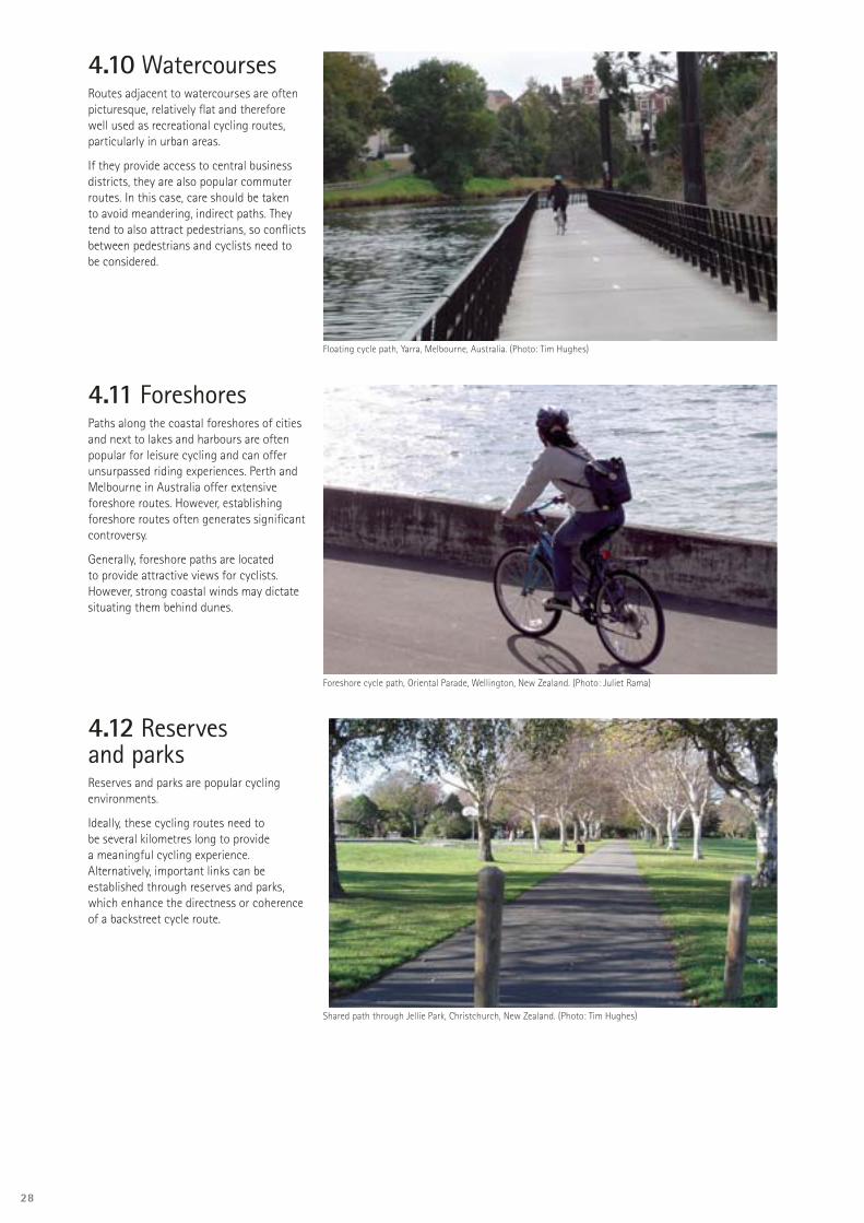
4.10 WatercoursesRoutes adjacent to watercourses are often picturesque, relatively fl at and therefore well used as recreational cycling routes, particularly in urban areas.
If they provide access to central business districts, they are also popular commuter routes. In this case, care should be taken to avoid meandering, indirect paths. They tend to also attract pedestrians, so confl icts between pedestrians and cyclists need to be considered.
4.11 ForeshoresPaths along the coastal foreshores of cities and next to lakes and harbours are often popular for leisure cycling and can offer unsurpassed riding experiences. Perth and Melbourne in Australia offer extensive foreshore routes. However, establishing foreshore routes often generates signifi cant controversy.
Generally, foreshore paths are located to provide attractive views for cyclists. However, strong coastal winds may dictate situating them behind dunes.
4.12 Reserves and parksReserves and parks are popular cycling environments.
Ideally, these cycling routes need to be several kilometres long to provide a meaningful cycling experience. Alternatively, important links can be established through reserves and parks, which enhance the directness or coherence of a backstreet cycle route.
Floating cycle path, Yarra, Melbourne, Australia. (Photo: Tim Hughes)
Foreshore cycle path, Oriental Parade, Wellington, New Zealand. (Photo: Juliet Rama)
Shared path through Jellie Park, Christchurch, New Zealand. (Photo: Tim Hughes)

29
4.13 Other locations• Undeveloped transport corridors• Dedicated bus lanes or corridors• Water and sewerage easements• Power line corridors• Conservation land tracks• Redundant road formations
4.14 Public transportPublic transport extends cyclists’ travel range. Buses, trains, ferries and planes could be considered part of the cycle route network, and links to public transport should be recognised in the cycle network plan.
Links to public transport can be critical to cyclists:• to ensure the viability of longer trips,
especially for cycle tourists• in hilly terrain• where there are poor, hazardous or non-
existent road options• where cycling is prohibited, for example
at some road tunnels or bridges• as part of a leisure experience.
The potential for multi-mode travel involving cycling is demonstrated in The Netherlands, where 35 percent of train travellers cycle to the station (MTPW and WM, 1992).
The viability of such links depends on appropriate:• cycle access at each end of the journey• cycle storage in transit• cycle parking at each end of a journey
if storage in transit is not possible, or where a key destination is adjacent to a transport interchange
• transit or storage costs.
Bicycles parked at railway station, Cambridge, United Kingdom. (Photo: Tim Hughes)
Bicycle rack on light rail, Portland, United States of America. (Photo: Tim Hughes)
30
Every street is a bicycle street (Geelong Bikeplan Study Steering Committee, 1977). Cyclists’ trip origins and destinations are as complex as those of car drivers, and they use all streets to access activities beside them. Whether or not such streets have specifi c cycling facilities, cyclists’ needs must be considered. This principle applies to all approaches to network planning.
If all streets and intersections provide quality cycling conditions, it is not necessary to provide for primary cycle routes. In practice, roads are arranged in a hierarchy so that longer-distance traffi c is concentrated on higher-standard routes. This is done for effi ciency and to manage traffi c effects on the enjoyment of adjoining land and vice versa. This usually requires a similar arrangement of provision for cycling.
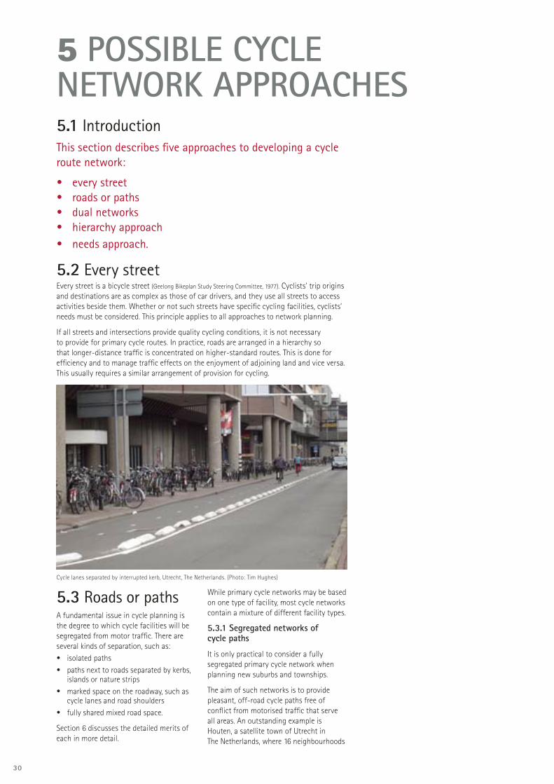
Cycle lanes separated by interrupted kerb, Utrecht, The Netherlands. (Photo: Tim Hughes)
5.1 IntroductionThis section describes fi ve approaches to developing a cycle route network:
• every street• roads or paths• dual networks• hierarchy approach• needs approach.
5.2 Every street
5 POSSIBLE CYCLE NETWORK APPROACHES
5.3 Roads or pathsA fundamental issue in cycle planning is the degree to which cycle facilities will be segregated from motor traffi c. There are several kinds of separation, such as: • isolated paths• paths next to roads separated by kerbs,
islands or nature strips• marked space on the roadway, such as
cycle lanes and road shoulders• fully shared mixed road space.
Section 6 discusses the detailed merits of each in more detail.
While primary cycle networks may be based on one type of facility, most cycle networks contain a mixture of different facility types.
5.3.1 Segregated networks of cycle paths
It is only practical to consider a fully segregated primary cycle network when planning new suburbs and townships.
The aim of such networks is to provide pleasant, off-road cycle paths free of confl ict from motorised traffi c that serve all areas. An outstanding example is Houten, a satellite town of Utrecht in The Netherlands, where 16 neighbourhoods

31
are accessed by car from a fast circumferential ring road. Motor vehicles can only travel between zones via the ring road. Within neighbourhoods, cyclists and motorists share the use of slow-speed (30 km/h) streets. Neighbourhoods are joined by a spine of cycle and walking paths that provide much shorter routes than for motor traffi c. As a result, 44 percent of trips less than 7.5 km long are made by bicycle and 23 percent by walking. Traffi c crash risk is half that of comparable towns.
Cycle path with right of way at intersection, Houten, The Netherlands. (Photo: Tim Hughes)
Other examples of full segregation have not been so successful. Milton Keynes (United Kingdom) suffered from sub-standard path design that has a poor safety record, and has failed to achieve higher modal share by cycling (Franklin, 1999). Canberra’s system also failed to live up to the expected benefi ts with only three percent of trips to work made by bicycle. This is largely due to a high quality of provision for cars and a lack of directness and coherence in the cycle path network for utility cycling. Canberra is now retrofi tting a primary cycle network to the arterial roads.
Cycle shelter near bus stop and underpass under ring road, Houten, The Netherlands. (Photo: Tim Hughes)
5.3.2 Road-based networks
Land use in already-existing towns makes it impractical to develop an off-road path network, so cycle networks are based around the established network of (mostly arterial) roads. There remains the issue of whether to provide a physically separated path beside the roadway.
Places such as Sweden, and Copenhagen in Denmark, have made an expensive commitment to redesigning arterial roads to provide cycle paths on berms behind relocated kerbs. More recently, and where there has not been enough funding to build cycle paths, some European towns have tried cycle lanes as an interim measure and found them successful.
5.3.3 General considerations
Many factors infl uence whether roads or paths will best suit cyclists’ needs. For example:• increased segregation from motor
traffi c is usually accompanied by increased interference from pedestrians, pets, skateboarders, slower cyclists etc
• one choice is not inherently safer than another; both can be hazardous and both require high-quality design to achieve safety — ‘the devil is in the detail’. Paths tend to be safer between intersections as long as there is room for adequate design and minimal crossing-driveway traffi c
• cycling through a junction on the roadway is generally safer than from a path. Junctions between paths and busier roads generally require traffi c calming or signals
• at junctions between paths and roads, New Zealand law requires cyclists on the path to give way, which reduces cyclist LOS
• geometric design standards for roads are often higher than for paths
• it is incorrect to suggest that roads can only satisfy commuters’ needs, or that paths cannot satisfy commuter cyclists’ needs. Most leisure cycling takes place on roads, and many commuters enjoy well located paths
• a road is not necessarily less expensive to maintain but will often benefi t through existing pavement management systems
• it is usually easier and less expensive to accommodate the needs of commuter cyclists on roads than on separate paths
• the freedom from traffi c danger and fumes brings obvious benefi ts for recreation cycling and novices (Dorrestyn, 1996a).
• it is diffi cult to provide a coherent and direct path system that is as convenient for commuters as the arterial road network
• where origins and destinations are on the same side of an arterial road, a two-way cycle path means cyclists don’t have to cross the road twice to get there. However, such two-way paths are generally not recommended.
5.3.4 Relative advantages
Subject to appropriate design standards being achieved, roads generally have the following advantages over paths.
They are:• direct• coherent• convenient• effi cient• available everywhere
and also:• have established intersection controls• serve well the needs of experienced
cyclists• have high levels of surveillance and
therefore personal security.
Between intersections, isolated paths generally have the following advantages over roads. They have:• no motor traffi c • slower speeds• low stress• an attractive environment
and also:• provide extra links that advantage
all cyclists• serve well the needs of
novice/child cyclists.
Depending on the circumstances and design detail, there is usually no clear advantage between roads and paths in relation to:• safety• confl ict with other users• expense • maintenance.

32
Dual path and lane facility, North Parade, Christchurch, New Zealand. (Photo: Tim Hughes)
5.4 Dual networks DescriptionDual networks provide two different types of cycle route network — for instance, one based on urban arterial roads, the other comprising cycle paths or backstreets.
Dual networks are sometimes provided within one road reserve. For example, a cycle path may be appropriate where it provides a short link for primary school aged children near shops or a school, even though it is beside an arterial road with cycle lanes.
A rural road may have a sealed shoulder suitable for experienced and sporting cyclists, but a path may also be provided for less experienced cyclists.
AdvantagesSome cyclists value off-road and backstreet options more than others. By providing choice, each can choose what suits them.
Even experienced cyclists will value more pleasant alternatives as long as they are still direct. As a rule of thumb, a 10 percent extra journey time has been suggested as sometimes acceptable (Hudson, 1982).
DisadvantagesWhere a dual network is provided within one road reserve, motorists may not expect cyclists to be riding on the road as well as on a path. This can compromise safety, especially when crossing driveways and side roads.
Dual network provision also costs more and may be seen politically as over-supply, especially if an element involves a signifi cant diffi culty or cost (fi nancial, or to other road users).
Recommendation Dual networks should be considered where the extra cost is outweighed by the benefi ts to cyclists.
If only one network can be funded, the LOS provided by each option to the different cyclist groups should be assessed. Consultation with cyclists over the choice will be important.
Having a path next to a roadway should not automatically exclude cyclists from using the road instead. On-road bans should only be instigated after assessing whether the paths and roadway meet the needs of all users in terms of technical standards. Other factors to consider include:• the potential for delay and confusion
at intersections and driveways • the adequacy of sight distances and
shoulder or lane widths • the adequacy of the path condition
and width • the potential for confl ict with other
path users • the relative LOS for cyclists of
different skills.
5.5 Hierarchy approachDescriptionCycle routes are sometimes assigned to hierarchies based on trip length and user type. For example, cycle routes in regional or district networks may be classifi ed as regional, inter-urban or tourist, while cycle routes in a large urban area may be classifi ed as principal, collector or local.
Principal routes are for longer-distance movement, are direct with minimal delays and may even be separated from motor traffi c to provide a ‘motorway’ LOS for cyclists. Collector routes distribute cycle traffi c between the principal routes and local origins and destinations (Cumming, 1996).
Some urban cycle route hierarchies aim to provide a designated cycle route within 100 m of each home (such as in Delft, The Netherlands).
AdvantagesHierarchies can be used to assign implementation priorities (so that routes higher in the hierarchy are implemented fi rst) and can be linked to design standards (so that more important routes provide a better LOS).
Disadvantage
A cycle route hierarchy will not work if using it involves signifi cant detours.
RecommendationConsider using cycle route hierarchies for setting target design standards, LOS and implementation priorities.

33
5.6 Needs approachThis approach involves choosing the option that best provides for cyclists’ needs in each situation.
It aims to achieve the best results for cyclists and other stakeholders within the context of all the prevailing opportunities and constraints. It may include any of the options or locations in this guide, as well as dual provision over some sections if it is needed and feasible.
When deciding on facilities that best meet cyclist needs, it is important to remember that each situation is different. Space limitations, cost and other constraints usually dictate one solution over another.
This guide recommends comparing the route options for each situation on their merits, and over the following pages provides processes and tools for developing, evaluating and comparing these options. Note that facilities within an area should be consistent so that users know what behaviour is expected of them, and so they can reliably predict the behaviour of others.
RecommendationAdopt the needs approach, but aim for consistent facility standards.
5.7 General recommendations for new and existing areasBelow are some suggestions for applying these approaches in various situations.
5.7.1 New areas
Design neighbourhood streets for slow, mixed traffi c.
Ensure cycling and walking networks are more closely spaced and permeable than motor traffi c networks; add traffi c-free links to achieve this. Ideally provisions for cyclists should be spaced less than 600 m apart.
Position paths in parks and reserves so that they link homes to signifi cant local destinations such as schools and community facilities, and so that children and novices do not have to mix with faster or busier traffi c.
Use paths to link communities along and across the barriers of busy roads.
Successful examples show a commitment to high-quality design, grade separation at main obstacles such as major roads, and careful attention to connections to the road network and across it.
5.7.2 Existing areas
Existing road hierarchies usually provide the basis for a primary cycle network.
Use the cycle planning process to identify places where people already cycle, and look for new opportunities of all the types of facilities described in this guide.
Develop options to improve the on-road provision and seek alternatives that will bypass obstacles or hazards or provide new, convenient links or alternatives for less competent cyclists.
Pay particular attention to intersections.
Consider the network needs of neighbourhood cyclists in their local environments.
Integrate with school travel planning initiatives and local area traffi c management planning.

34
Planning cycle routes involves considering the most appropriate facility for any particular situation. This chapter identifi es the available facility types and their advantages and disadvantages.
6 POSSIBLE CYCLE ROUTE COMPONENTS
6.2 Provision requirementsThe New Zealand supplement to Austroads Guide to traffi c engineering practice: Part 14:
Bicycles (Transit New Zealand, 2004) (CDS) is the main design guidance tool for cyclist facilities on roads and paths.
Figure 6.1 is a guide to the desirable facilities in the road corridor for cyclists in relation to traffi c volume and speed and is most useful when planning for new situations. In practice, constraints on space, presence of side roads and driveways, type of users and costs will also dictate the choice of facilities to retrofi t to existing situations. These and other considerations are discussed below.
The fl ow chart in Figure 6-15 of the Cycle design supplement is a guide to choosing the desirable path facilities for cyclists in different circumstances.
6.3 Mid-block facilities Cycle facilities that can be provided between intersections include:• kerbside cycle lanes• cycle lanes next to parking• contra-fl ow cycle lanes• wide kerbside lanes• sealed shoulders• bus-bike lanes• transit lanes• mixed traffi c• paths.
Cyclists do not always need special or dedicated facilities. They do need provisions appropriate to their needs. For instance, wide kerbside lanes on arterial roads have similar benefi ts for cyclists as bicycle lanes (Hunter, 1998). However, cyclists prefer marked cycle lanes wherever possible.
Depending on the circumstances, cyclists may fi nd the following provision quite adequate, without dedicated facilities:• wide kerbside lanes• sealed shoulders• bus-cycle lanes• shared paths• slow, mixed traffi c• lightly traffi cked streets of adequate width• unsealed roads and paths• one-way streets where signs and markings permit two-way use by cyclists.
However, it may be necessary to use special guide or route signs to ensure a cycle route that includes such provision forms part of a coherent network.
6.1 Introduction

35
Traffic speed (85th percentile, km/h)
Volu
me
of m
otor
veh
icle
s (v
ehic
les/
day)
CYCLE LANES
MIXED TRAFFIC
CYCLE PATHS
NOTE: THIS DIAGRAM IS TO BEAPPLIED TO URBAN ROADS ANDIS NOT APPROPRIATE FORRURAL OR NON-URBAN ROADS
0
3,000
6,000
30 50 70 100
COMBINATIONS OF LOWSPEEDS AND HIGH TRAFFICVOLUMES ARE VERY RARE.WHEN THESE CONDITIONSOCCUR, SEGREGATION MAYBE DESIRABLE IN ORDER TOMINIMISE CONFLICTS.
9,000
12,000
CYCLE PATHS WITHSEPARATING VERGE
SEALED SHOULDERS
2010 40 60 80 90
1,000
2,000
4,000
5,000
7,000
8,000
10,000
11,000
Mixed
traffic
Cycle lanes or
sealed shoulders
Cycle paths
Figure 6.1: Preferred separation of bicycles and motor vehicles according to traffi c speed and volume.This diagram is based on RTA NSW (2003) and Jensen et al (2000), also DELG (1999), Ove Arup and Partners (1997) and CROW 10 (1993).
Figure 6.1: Notes 1. In general, roads with higher traffi c speed and traffi c volumes are more diffi cult for cyclists to negotiate than roads with lower speeds and volumes. The threshold for comfort and safety for cyclists is a function of both traffi c speed and volume, and varies by cyclist experience and trip purpose. Facilities based on this chart will have the broadest appeal.
2. When school cyclists are numerous or the route is primarily used for recreation then path treatments may be preferable to road treatments.
3. Provision of a cycle path does not necessarily imply that an on-road solution would not also be useful, and vice-versa. Different kinds of cyclists have different needs. Family groups may prefer off-road cycle paths while racing or training cyclists, or commuters, tend to prefer cycle lanes or wide sealed shoulders.
36
Kerbside cycle lane, East Coast Road, North Shore City, New Zealand. (Photo: Tim Hughes)
Cycle lane outside angle parking, Greers Road, Christchurch, New Zealand. Note: clearance is barely suffi cient. (Photo: Tim Hughes)
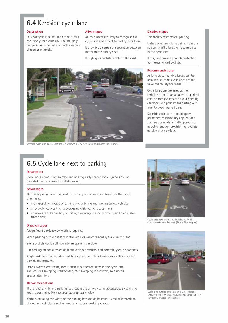
6.4 Kerbside cycle laneDescriptionThis is a cycle lane marked beside a kerb, exclusively for cyclist use. The markings comprise an edge line and cycle symbols at regular intervals.
AdvantagesAll road users are likely to recognise the cycle lane and expect to fi nd cyclists there.
It provides a degree of separation between motor traffi c and cyclists.
It highlights cyclists’ rights to the road.
DisadvantagesThis facility restricts car parking.
Unless swept regularly, debris from the adjacent traffi c lanes will accumulate in the cycle lane.
It may not provide enough protection for inexperienced cyclists.
Recommendations As long as car parking issues can be resolved, kerbside cycle lanes are the favoured facility for roads.
Cycle lanes are preferred at the kerbside rather than adjacent to parked cars, so that cyclists can avoid opening car doors and pedestrians darting out from between parked cars.
Kerbside cycle lanes should apply permanently. Temporary applications, such as during daily traffi c peaks, do not offer enough provision for cyclists outside those periods.
6.5 Cycle lane next to parkingDescriptionCycle lanes comprising an edge line and regularly spaced cycle symbols can be provided next to marked parallel parking.
AdvantagesThis facility eliminates the need for parking restrictions and benefi ts other road users as it:• increases drivers’ ease of parking and entering and leaving parked vehicles • effectively reduces the road-crossing distance for pedestrians • improves the channelling of traffi c, encouraging a more orderly and predictable
traffi c fl ow.
DisadvantagesA signifi cant carriageway width is required.
When parking demand is low, motor vehicles will occasionally travel in the lane.
Some cyclists could still ride into an opening car door.
Car parking manoeuvres could inconvenience cyclists, and potentially cause confl icts.
Angle parking is not suitable next to a cycle lane unless there is extra clearance for parking manoeuvres.
Debris swept from the adjacent traffi c lanes accumulates in the cycle lane and requires sweeping. Traditional gutter sweeping misses this, so it needs special attention.
RecommendationsIf the road is wide and parking restrictions are unlikely to be acceptable, a cycle lane next to parking is likely to be an appropriate choice.
Kerbs protruding the width of the parking bay should be constructed at intervals to discourage vehicles travelling over unoccupied parking spaces.
Cycle lane next to parking, Marshland Road, Christchurch, New Zealand. (Photo: Tim Hughes)

37
6.6 Contra-fl ow cycle laneDescriptionContra-fl ow lanes allow cycling against the legal direction of travel in a one-way street. They have the same features as traditional cycle lanes and are located so that cyclists ride in the normal position on the left. (Cyclists pass motorists right shoulder to right shoulder.)
AdvantagesContra-fl ow lanes contribute to the network’s directness and coherence by allowing cyclists to avoid diversions along indirect or less safe routes.
See section 6.4 Kerbside cycle lane.
DisadvantagesOther road users, including pedestrians, may not expect cyclists to travel in the opposite direction to other traffi c.
Contra-fl ow lanes generally preclude parking on the cyclist’s side of the road, though exceptions may be possible in traffi c-calmed situations.
RecommendationsContra-fl ow cycle lanes should be used in one-way streets where cyclists might otherwise be forced to divert along indirect or less safe routes.
Any new proposal for a contra-fl ow cycle lane should be well publicised.
Intersection layouts must support this facility, particularly at start and end points and at side road intersections.
Contra-fl ow lanes should have a:• contrasting surface• road markings or islands separating the opposing directions of fl ow.
Contra-fl ow cycle lane, Cambridge, United Kingdom. (Photo: Tim Hughes)
6.7 Wide kerbside laneDescriptionA wide kerbside lane is wide enough to allow cyclists and motor traffi c to travel beside each other with a reasonable degree of comfort. It can be used where there is not enough road width for cycle lanes or as prescribed by CDS Figure 4-1. It is the preferred on-road facility where part-time parking is required, such as in clearways.
AdvantagesThis facility requires less space than the combined width of a travel lane and a cycle lane.
It is easily implemented by re-marking the position of a kerb lane line, subject to width requirements.
DisadvantagesWide kerbside lanes do not highlight cyclists’ legitimate presence on the road.
Car parking restrictions are required.
Motor traffi c in the wider left lane may travel faster.
RecommendationsWide kerbside lanes should be considered where no other facility is possible.
The road surface next to the kerb side of the road must be of a high quality.
Wide kerbside lane, Burwood Highway, Melbourne, Australia. (Photo: Tim Hughes)
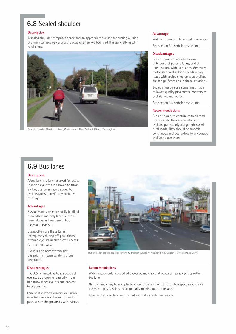
38
6.8 Sealed shoulderDescriptionA sealed shoulder comprises space and an appropriate surface for cycling outside the main carriageway, along the edge of an un-kerbed road. It is generally used in rural areas.
Advantage Widened shoulders benefi t all road users.
See section 6.4 Kerbside cycle lane.
DisadvantagesSealed shoulders usually narrow at bridges, at passing lanes, and at intersections with turn lanes. Generally, motorists travel at high speeds along roads with sealed shoulders, so cyclists are at signifi cant risk in these situations.
Sealed shoulders are sometimes made of lower-quality pavements, contrary to cyclists’ requirements.
See section 6.4 Kerbside cycle lane.
RecommendationsSealed shoulders contribute to all road users’ safety. They are benefi cial to cyclists, particularly along high-speed rural roads. They should be smooth, continuous and debris-free to encourage cyclists to use them.
Sealed shoulder, Marshland Road, Christchurch, New Zealand. (Photo: Tim Hughes)
6.9 Bus lanesDescriptionA bus lane is a lane reserved for buses in which cyclists are allowed to travel. By law, bus lanes may be used by cyclists unless specifi cally excluded by a sign.
AdvantagesBus lanes may be more easily justifi ed than either bus-only lanes or cycle lanes alone, as they benefi t both buses and cyclists.
Buses often use these lanes infrequently during off-peak times, offering cyclists unobstructed access for the most part.
Cyclists also benefi t from any bus priority measures along a bus lane route.
DisadvantagesThe LOS is limited, as buses obstruct cyclists by stopping regularly — and in narrow lanes cyclists can prevent buses passing.
Lane widths where drivers are unsure whether there is suffi cient room to pass, create the greatest cyclist stress.
RecommendationsWide lanes should be used wherever possible so that buses can pass cyclists within the lane.
Narrow lanes may be acceptable where there are no bus stops, bus speeds are low or buses can pass cyclists by temporarily moving out of the lane.
Avoid ambiguous lane widths that are neither wide nor narrow.
Bus-cycle lane (but note lost continuity through junction), Auckland, New Zealand. (Photo: David Croft)

39
6.10 Transit laneDescriptionA transit lane can only be used by public passenger vehicles, motor cycles, cycles and motor vehicles carrying a specifi ed minimum number of passengers. From a cycling perspective, it is similar to a bus lane.
RecommendationTransit lanes must be wide so that cyclists and motor traffi c can travel in parallel within them.
6.11 Mixed traffi cDescriptionMost roads are mixed traffi c roads, where no formal cycle facilities are provided and cyclists share the roads with other road users.
There are two types of urban mixed traffi c situations. These occur where:• traffi c volumes are low, traffi c conditions are straightforward, and there is enough
space for motor vehicles to overtake cyclists • traffi c is slowed to near cycle speeds, the road is narrow and cyclists and motor
vehicles share the same space travelling in single fi le.
Situations where drivers are unsure whether there is enough space to overtake appear to create the greatest stress.
AdvantageThere are few costs apart from traffi c calming, which is also done for other reasons.
DisadvantageContinuity of route standards may be compromised where there are mixed traffi c conditions on a route that is part of the primary cycle network.
RecommendationsCycle facilities may not be required if the roads are in an appropriate condition.
Ensure the continuity and integrity of cycle routes by using signage and continuing cycle lanes where mixed conditions are otherwise appropriate.
Ensure the environment makes it clear where cyclists have room to travel beside motor traffi c or need to travel single fi le. Avoid ambiguous widths and layouts.
Mixed traffi c on backstreet, Delft, The Netherlands. (Photo: Tim Hughes)

40
6.13 Exclusive cycle pathDescriptionAn exclusive cycle path can only be used legally by cyclists.
AdvantagesOn exclusive cycle paths cyclists can generally proceed without delays caused by, or in confl ict with, other path users.
This facility can offer cyclists a higher LOS.
DisadvantageWalkers sometimes use exclusive cycle paths when their own facilities are comparatively poor.
RecommendationsExclusive cycle paths are preferred where they are likely to be used by a signifi cant volume of commuter cyclists.
Care is required to ensure pedestrians can be well accommodated elsewhere.
Exclusive cycle path, Southern Veloway, O’Halloran Hill, South Australia. (Photo: Kym Dorrestyn)
6.12 Paths — generalThere are three main path types for cyclists:• exclusive cycle path• shared path• separated path.
Each may be isolated from roads or right next to them. A ‘cycle path next to road’ is also discussed on page 42.
Cycling through Hagley Park, Christchurch, New Zealand. (Photo: Neil Macbeth)

41
6.14 Shared path DescriptionA shared path is shared with pedestrians and possibly others (for example horse riders).
AdvantagesThis facility is useful to cyclists as well as pedestrians, and therefore maximises the benefi t of the path to the general community.
It is benefi cial to vulnerable cyclists where an existing footpath can be adapted or widened.
DisadvantagesConfl ict between cyclists and pedestrians is common where, for instance, there is a signifi cant volume of cyclists and pedestrians or a mix of recreational walkers and commuting cyclists.
The LOS for cyclists can be poor where interference by other path users results in slower speeds.
See also 6.16 Cycle path next to road.
RecommendationsShared paths are benefi cial to a range of path users but need to be managed effectively. They are appropriate where both cyclists and pedestrians need a path, but their numbers are modest.
It is important that:• the path’s design is suitable for its use and demand• authorities adequately monitor users’ behaviour on the path. • the connections between path, road and driveways are carefully considered.
Shared path, Wairere Drive, Hamilton, New Zealand. (Photo: Paul Ryan)
6.15 Separated path DescriptionThis is a path with separate sections for cyclists and pedestrians.
AdvantagesSeparated paths may help to avoid the confl ict between pedestrians and cyclists that is common on shared paths.
Cyclists can ride without the delays possible on paths shared with walkers.
DisadvantagesHigher cyclist speeds are possible, but having a cycle path close to pedestrians means they can stray into the cycling space.
Separated paths are wider than other paths, so they cost more.
RecommendationsSeparated paths are appropriate if large numbers of cyclists and pedestrians will use them.
There should be adequate separation (such as different path levels) between cyclists and pedestrians.
Separated path with barrier rail, Bielefeld, Germany. (Photo: Tim Hughes)

42
DescriptionThis is a common facility in Europe, usually for one-way cycle traffi c. The paths are generally paved in a different colour and texture from adjoining sections of the berm, and may also be separated by a low kerb.
Confl ict at bus stops, Copenhagen, Denmark. (Photo: Tim Hughes)
Pedestrians obstruct cycle path while waiting to cross, Bielefeld, Germany. (Photo: Tim Hughes)
One way cycle path next to road, Utrecht, The Netherlands. (Photo: Tim Hughes)
6.16 Cycle path next to road
AdvantagesCycle paths next to roads can offer a low-stress environment that can be attractive to many cyclists.
They can be particularly helpful for short lengths, such as at squeeze points in the road carriageway.
DisadvantagesUnder New Zealand traffi c law, cyclists on paths are required to give way to other traffi c when crossing side roads. This results in delay for cyclists.
Intersections are where cyclists are at the highest risk. In Europe, paths on berms have been shown to be less safe at junctions than if the cyclist was on the roadway. For this reason best European practice requires cycle tracks to return to the roadway before intersections. At signals, special cycle phases can be introduced for cycle paths, at the expense of complexity and delay to all road users.
The benefi ts of cycle paths alongside a road between junctions can be negated by:• inadequate clearance for visibility at
driveways• frequent or busy driveways• inadequate clearance from opening
doors of parked vehicles
• bus passengers boarding and alighting from the cycle path
• pedestrians encroaching on the cycle path when the footpath is congested, or while waiting to cross
• garbage awaiting collection obstructing the path.
Where cyclists ride in both directions along paths, drivers using driveways and side roads may not expect cycle traffi c from both directions. Best European practice outlaws two-way cycle paths alongside roads with access from driveways and side roads.
It is less convenient to turn right from a cycle path next to a road. Cyclists have to cross the whole traffi c stream in one manoeuvre, whereas from a cycle lane they can fi rst merge across to the centre. However, a right turn from a separate path may be safer.
It is generally expensive to establish this facility, due to relocating kerblines.
RecommendationsBetween intersections, cycle paths next to roads can provide attractive and safe facilities for a wide range of cyclists, provided there is adequate space and interference from other users is minimal.
Carefully consider safety and delay at intersections, where it is usually preferable for the path to rejoin the roadway.
Cycle path by Albany Highway, North Shore City, New Zealand. (Photo: Tim Hughes)
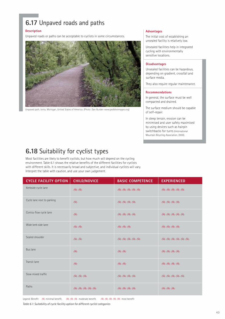
43
DescriptionUnpaved roads or paths can be acceptable to cyclists in some circumstances.
6.17 Unpaved roads and pathsAdvantagesThe initial cost of establishing an unsealed facility is relatively low.
Unsealed facilities help in integrated cycling with environmentally sensitive locations.
DisadvantagesUnsealed facilities can be hazardous, depending on gradient, crossfall and surface media.
They also require regular maintenance.
RecommendationsIn general, the surface must be well compacted and drained.
The surface medium should be capable of self-repair.
In steep terrain, erosion can be minimised and user safety maximised by using devices such as hairpin switchbacks for turns (International Mountain Bicycling Association, 2000).
6.18 Suitability for cyclist typesMost facilities are likely to benefi t cyclists, but how much will depend on the cycling environment. Table 6.1 shows the relative benefi ts of the different facilities for cyclists with different skills. It is necessarily broad and subjective, and individual cyclists will vary. Interpret the table with caution, and use your own judgement.
CYCLE FACILITY OPTION CHILD/NOVICE BASIC COMPETENCE EXPERIENCED
Kerbside cycle lane55 55555 55555
Cycle lane next to parking5 5555 5555
Contra-fl ow cycle lane5 5555 55555
Wide kerb side lane55 555 5555
Sealed shoulder55 55555 555555
Bus lane5 55 5555
Transit lane5 55 5555
Slow mixed traffi c555 5555 55555
Paths55555 5555 555
Legend: Benefi t: 5 minimal benefi t, 555 moderate benefi t, 55555 most benefi t
Table 6.1: Suitability of cycle facility option for different cyclist categories
Unpaved path, Ionia, Michigan, United States of America. (Photo: Dan Burden www.pedbikeimages.org)

44
6.19 Intersections 6.19.1 General
When planning intersections for cyclist use, the goal is to accommodate cyclists safely with a reasonable LOS, and at a reasonable cost, within the available constraints.
6.19.2 Key principles
The key planning principles relate to the type of intersection control and the provision of adequate space.
The design should ensure that:• the intersection performs effi ciently
for cyclists under the traffi c conditions expected throughout the planning period
• it is as far as possible suitable for cyclists of basic competence
• all normal manoeuvres are possible, particularly right turns (including the option of hook turns)
• the confl ict area between through-cyclists and left-turning traffi c (especially heavy vehicles) is managed. Left-turn slip lanes can simplify this by moving left-turning traffi c confl ict points away from the intersection and providing space for hook turns
• confl ict points are easily identifi ed• cyclists and drivers know where cyclists
are expected to be on the road • the intersection is consistent in
alignment and standards with mid-block facilities on approach and departure.
Helpful design information can be found in the CDS, Vicroads (2001), Austroads (1999) and Transfund New Zealand (2003).
6.19.3 Roundabouts
A higher proportion of cyclist injuries happens at roundabouts than at any other intersection type. Multi-lane roundabouts are the main culprits and should be avoided on cycle routes where possible.
Small, single-lane roundabouts, that are designed to tame traffi c speeds, have been proven to reduce cycling injuries. These roundabouts slow traffi c by using the shape of the islands to defl ect traffi c onto a curved path, and by ensuring visibility to other traffi c is not excessive. They require no special provision for cyclists (Austroads, 1999; Bach and Diepens, 2000).
External perimeter paths should be considered for large multi-lane roundabouts (Austroads, 1999; Bach and Diepens,
2000), but will generally result in a poor LOS for cyclists owing to crossing delays. Grade separation or conversion to traffi c signals is strongly preferred over multi-lane roundabouts.
Cycle lane leading to advanced stop box, Colombo Street, Christchurch, New Zealand. (Photo: Neil Macbeth)
Hook turn, trial markings, Merivale, Christchurch, New Zealand. (Photo: Andrew Macbeth)
Slip lane treatment, Hamilton, New Zealand. (Photo: Tim Hughes)
Cycle lane diverts to cycle path to negotiate multi-lane roundabout, Otaha Valley Road, Albany, New Zealand. (Photo: Tim Hughes)
Grade separation at multi-lane roundabout, Wairere Drive, Hamilton, New Zealand. (Photo: Paul Ryan)

45
6.20 StructuresA number of structures are used in association with cycle provision, such as bridges, underpasses and overpasses.
This section outlines a number of grade separation options that aim to help cyclists cross railways and high-volume, high-speed roads that have signifi cant risks and potential for delays.
Railway cycle underpass and footpath, Utrecht, The Netherlands. (Photo: Tim Hughes)
Bridges need to be much higher to clear trucks using a road, than underpasses carrying cyclists need to be down below a road. Cyclists also prefer to speed up going down a ramp to an underpass, and use their momentum to travel up the ramp on the other side. Bridge ramps are generally higher requiring more effort to negotiate.
However, bridges are generally less expensive, have no drainage requirements, have fewer lighting requirements and offer advantages in personal security and vandalism.
Site topography may favour either a bridge or an underpass.
Covered bridge over railway prevents objects being dropped and provides shelter, Cambridge, United Kingdom. (Photo Tim Hughes)
Personal security is important. CROW (1993) provides numerous suggestions to enhance personal security at tunnels.
Because structures are expensive, the needs of cyclists and others must be properly identifi ed, particularly in relation to:• constructing a motorway• planning new residential areas• designing a structure.

46
6.21 Traffi c calmingTraffi c calming devices can improve cycling conditions in local streets with mixed traffi c conditions. A wide variety of devices are used, so accommodating cyclists will depend on the individual characteristics of the devices.
For example, cyclist bypasses are generally appropriate where there are:• single-lane devices• road narrowings• devices with abrupt changes in vertical
alignment.
Bypass facilities can often be constructed using the original carriageway surface.
Other measures that may be appropriate are:• path links at road closures• contra-fl ow lanes or path links at
one-way devices.
6.22 Restricted traffi c areasPedestrian needs and comfort are paramount in pedestrian zones and public places where traffi c is restricted. In these areas, the desirability of cycling (and any associated provisions) needs to be determined — bearing in mind that it is important to accommodate cyclists whose desire lines pass through a pedestrian area.
The common options are:
• allowing cyclists and pedestrians to mix freely
• providing designated paths for cyclists through the area
• allowing a combined use with selected motor vehicles (for example, buses, taxis and service vehicles)
• restricting cycling during certain periods• prohibiting cycling in certain places.
The most appropriate approach will depend on the situation and the nature and behaviour of both pedestrians and cyclists.
Permitted cyclists are guests, and are expected to travel at a speed and in a way that is consistent with a walking space and to yield to pedestrians unless they have their own defi ned space.
Priority should go to information signs and public relations campaigns for the peaceful coexistence of pedestrians and cyclists, with minimal use of signs and line markings.
6.23 Complementary facilitiesEnd-of-trip facilities (such as secure parking, lockers and showers) and trip facilities such as shelter, water and toilets are important infrastructure for cyclists. These are covered in section 3.6.
Speed cushions with cycle lane bypass, Melbourne, Australia. (Photo: Tim Hughes)
Cyclists walk through pedestrian precinct on riverside cycle way, Portland, Oregon, United States of America. (Photo: Tim Hughes)

THE CYCLE NETWORK
PLANNING PROCESS
CHAPTER 7 ASSESSING CYCLE DEMAND
CHAPTER 8 IDENTIFYING CYCLE ROUTE OPTIONS
CHAPTER 9 EVALUATING CYCLE ROUTE OPTIONS
CHAPTER 10 THE CYCLE NETWORK PLAN
CHAPTER 11 PRIORITISATION
CHAPTER 12 IMPLEMENTATION
CHAPTER 13 MONITORING
CHAPTER 14 CONSULTATION

48
7 ASSESSING CYCLE DEMANDASSESS CYCLE DEMAND
Map cycling trip origins and destinations.
Map land use using district planning data. Assess their importance as cycling trip generators. Map desire lines.
Map existing cycle routes and the numbers of cyclists using them.
Map cycle crashes.Map existing cycle facilities.Count and map cycle traffi c and parked cycles.Consult and/or survey cycle users.Assess trip purposes and types of cyclists.
Identify infrastructure barriers, using discrepancies between desired and actual use.
Assess, map and quantify latent demand: what additional cycling could be expected with better conditions and promotion?
7.1 IntroductionTo know what to provide for cyclists, and where, it is important to have good information — such as how many people cycle or wish to cycle, where they wish to ride, for what purpose they ride, and how competent they are to handle a variety of conditions.
To help build this picture, this chapter describes cyclists’ trip origins and destinations, methods for identifying the routes cyclists take, and the types and numbers of cyclists who use them or who may use them in the future.
7.2 Cyclists’ origins and destinationsCyclists may wish to cycle everywhere. Particular origins and destinations include:• residential areas• tourist accommodation• education establishments• areas with large employment • shopping areas• leisure and entertainment facilities• public facilities• public transport interchanges• historic and tourist sites.
By mapping these locations, trip desire lines can then be plotted, permitting a qualitative assessment of where cycle demand is likely to be signifi cant. Methods for identifying origins and destinations are outlined below. They may be supplemented by questionnaires.
7.2.1 City/district planning information
DescriptionDistrict planning documents map the existing land use and the hierarchy of roads. They also contain information about land use zones and growth areas, major residential subdivisions or commercial or community developments. They are a most useful source of primary data about likely origins and destinations of cyclist trips. A higher concentration of cyclists can be expected near popular cycling destinations.
AdvantagesThis information is readily available and helps identify cyclists’ origins and destinations.
DisadvantageThis method provides no information about numbers of cyclists or the routes they use.
RecommendationIdentify where cycle traffi c could be expected by plotting cyclists’ signifi cant trip origins and destinations on a map, alongside any existing cycle facilities and the road hierarchy.

49
RecommendationIf using this method, be aware of its limitations.
7.2.2 Census data
DescriptionThe fi ve-yearly Census includes questions about the mode of travel to work on Census Day and the locations of the respondent’s residence and workplace.
This data can identify the number and distribution of residents and employees in various age brackets and those who cycled to work on Census Day.
AdvantagesThis data provides reliable numbers. It can be used to plot graphically the signifi cance of areas as origins and destinations for cyclists’ trips to work and by connecting them, the desire lines for commuting to work.
Plotting family size or population density in school-age or the 30 to 45 age bracket may allow a comparison of the likely uptake of cycling in different parts of cities. Larger families and these age groups are likely to yield more cyclists.
DisadvantagesThere are disadvantages in time and cost. It duplicates some of the qualitative information available from land use which may sometimes be suffi cient for the purpose.
Census data does not reveal cyclists’ route choices.
The Census trip-to-work data is a snapshot of one day. It is affected by weather and any other factors peculiar to that day and provides no data about cycling trips that are not trips to work.
RecommendationsDuring network planning, count parked cycles to quantify existing school cycle demand.
During route planning, use questionnaires to identify detailed information on route choice and problem areas. Where possible, incorporate this survey into a Safer Routes to School programme.
7.2.3 School cycle traffi c
DescriptionSchool cycle traffi c is localised and likely to be a signifi cant proportion of the total cycling in many areas. If not, a poor cycling environment is likely to be suppressing use.
Questionnaires and counting parked cycles are commonly used to assess cycle demand at schools.
By obtaining the number of students attending school on a survey day, the percentage of students cycling to school can be calculated.
AdvantageA school represents a concentration of cycle users who are relatively easy to survey.
DisadvantagesSurveying school cycle traffi c:
• requires school approval• has a time and cost factor, especially
when questionnaires are used• is limited as some areas have few
children cycling to school.
Plot of locations where school children have had a cycle crash (black spots) or feel unsafe (green spots). Source: Christchurch City Council, New Zealand.

50
RecommendationDevelop a program for counting parked bicycles at key destinations.
7.2.5 Counting parked bicycles
Counting the number of bicycles parked at particular locations on a typical day can help determine the signifi cance of those places as cyclist destinations.
AdvantageCounts of parked cycles are particularly useful for places with defi ned cycle parking places such as schools. They are quick and simple to perform.
RecommendationsUse any available information from local transport planning or modelling surveys; otherwise use the LTSA travel survey data.
7.2.6 Travel surveys
DescriptionInformation on cycle demand can be gleaned from surveys conducted for transport planning and modelling, or from LTSA travel surveys.
AdvantageThe New Zealand Travel Survey 1997/98
(LTSA, 2000), available on the LTSA website (www.ltsa.govt.nz), identifi es the general characteristics of cycle trips and the people who cycle.
DisadvantageThe LTSA travel survey is a national survey, so the results do not necessarily refl ect the characteristics of an individual study area. It does not identify routes.
7.3 Desire lines and barriersThe cycle demand information gathered should be reviewed and the major trip origins and destinations plotted on a map, followed by the major desire lines linking origins and destinations.
Such maps permit barriers to cyclists travelling along these desire lines to be identifi ed. Barriers could include waterways, motorways, railways, large industrial estates and sections of road that cyclists perceive as hazardous. The latter might include heavily traffi cked roads that have to be crossed or travelled along, multi-lane roundabouts, or sections of busy roads with no dedicated space for cyclists.
7.2.4 Visitor numbers
DescriptionThis method uses the total number of visitors to particular locations, attractions or facilities to indicate their likely signifi cance as cyclist destinations.
RecommendationUse this method where the information is readily available.
DisadvantageThere are disadvantages in time and cost if the information is not readily available.
AdvantageAs long as the information is readily available, this is a quick method for prioritising sites for more detailed investigation, such as counting cycle traffi c or parked cycles.

51
Recommendations This method is a good way to begin assessing cycle demand. Other cycle demand assessment methods should be used to refi ne further the understanding of cycle travel patterns in an area.
7.4.1 Road hierarchy method
DescriptionDistrict plans usually include maps of the road hierarchy in their areas (typically arterial, collector and local roads).
A fi rst assumption could be that the number of cyclists wishing to use a particular link in the road network will be in direct proportion to those using motor traffi c on that link. So highly traffi cked roads could be expected to carry relatively high volumes of cycle traffi c, given appropriate cycling conditions.
AdvantageThis method gives the simplest and quickest indication of potential cycle demand across the whole area.
DisadvantagesCyclists may avoid sections of arterial roads that they perceive as hazardous or unpleasant for cycling, or may take a short cut not available to motor traffi c.
Cycling conditions may be perceived as so dangerous or unpleasant that people either cease cycling or don’t take it up in the fi rst place. This suppressed or latent demand for cycling might be realised if cycling conditions were improved.
7.4 Use of routes by cyclists
RecommendationsUse this method, but be aware of its limitations.
Start with LTSA data. For a more complete picture, supplement this with ambulance and RCA data, but remove any duplicate data from the combined database to avoid double counting.
7.4.2 Cycle crash data
DescriptionCycle crash data for a long period of time can indicate those routes that cyclists have diffi culty negotiating safely.
Useful crash data can be obtained from the LTSA, ambulance services and RCAs’ databases of locally reported crashes.
AdvantageThis data is readily available and is also needed for evaluating cycle route options.
DisadvantagesLTSA data generally excludes crashes that do not involve a motor vehicle, and off-road crashes.
Ambulance data has good location information but is biased towards the more serious injuries.
This method will be poor at identifying:
• sections of the road network that carry signifi cant numbers of cyclists and are relatively safe for cyclists
• off-road routes (ambulance data is useful here).
Also, cyclists may avoid hazardous sections of an otherwise desirable cycle route.
Crash plot showing LTSA data (black dots) and ambulance data (blue dots)(Source: Christchurch City Council)

52
AdvantageCycle traffi c counts provide hard, conclusive evidence of existing cycle demand.
DisadvantageThe method only has time and cost disadvantages.
RecommendationEach local authority should carry out an annual programme of cycle counts to monitor cycle use trends and provide data to support funding applications.
In addition to counting cycles using sections of routes soon to be investigated or designed in detail, it is recommended that some strategic counts be repeated annually. This could include counting cycles crossing a cordon around the central business district and or other key cyclist destinations, as well as on some outlying arterial routes.
7.4.4 Cycle counts
Manual cycle countsIn this method, people at cycling sites record the numbers of cyclists, their travel direction, and possibly whether each cyclist is a primary school pupil, secondary school student or adult.
At busy sites cyclists should be counted separately rather than as part of a general traffi c count, as they are easily overlooked. Counting is usually done during the morning or afternoon peak, but counts undertaken at other times can also be scaled up (see Appendix 2).
The methods already mentioned will indicate where to start counting.
Automated cycle countsAutomatic mechanical counters can be used to count bicycles, even in conjunction with counting other traffi c (Transfund, 2002).
Installing continuous automated counters on key routes provides control data for monitoring cycle use on the network. This can also be used for scaling short-term, seasonally affected or weather-affected counts and for calculating modal split.
Bicycle detectors at traffi c signals can also be used to regularly monitor the number and time pattern of cycle use. Beware of false counting of cars driving in adjacent lanes or straying into the cycle lane.
Detector loops on railway cycle path, Christchurch, New Zealand. (Photo: Axel Wilke)
DisadvantageThe existence of cycle facilities does not always indicate signifi cant cycle traffi c, as they may be poorly sited or isolated.
7.4.3 Existing cycle facilities
DescriptionThis method involves plotting on a map the location of any existing cycle facilities. This may indicate where cycle demand is, or has been considered, signifi cant.
AdvantageThis information has more than one use, as it is part of the base inventory required before cycle route options are evaluated.
RecommendationUse this method as it provides information needed for other purposes, including cycling promotion.

53
7.4.5 Consultation with cycle users
DescriptionThis method involves consulting local bicycle users on popular cycle routes with which they are familiar in the areas where they cycle.
AdvantagesBicycle users usually have excellent local knowledge of the routes they use and their associated problems. This can also be an excellent way of identifying leisure cycle routes.
DisadvantagesIndividual cyclists, unless they cycle many different routes, can talk accurately only about the number of routes with which they are familiar. It is necessary to speak to a representative group of cyclists covering all areas.
Experienced cyclists may not be able to represent less confi dent, new cyclists’ needs and desires.
RecommendationUse this method. If there is no bicycle users’ group, convene one for the purpose of ongoing liaison during cycle planning and implementation.
AdvantagesThe route and hazard information is usually plotted on a map of the study area and can be used to identify route, or site-specifi c, improvements.
Information about the type of cyclist is needed to identify the most appropriate type of facility for any route in the network.
RecommendationsThis method is recommended where the above methods do not provide suffi cient information. If questionnaires have not been used for network planning, they should still be considered for route planning.
Developing and using a questionnaire are not simple exercises; it may be wise to seek specialist advice to ensure cost-effective and useful results.
7.5 QuestionnairesDescriptionQuestionnaires help to identify:• the types of cyclist• origins and destinations• routes travelled• hazard locations• crash or incident locations• alternative routes cyclists would use
if hazards or barriers were removed• reasons why people do not cycle, the
infrastructure or other measures that would induce them to cycle, and the routes they would take.
Questionnaire distribution methods include:• newspapers• cycle shops, libraries or places that
cyclists visit often• the internet: survey forms can be
copied from the internet and posted to the surveyor, or the survey could be completed and submitted online
• placing questionnaires on parked bicycles
• roadside interviews• handing out questionnaires to cyclists
on popular cycle routes• in classrooms for school surveys, and
at tertiary institutions and workplaces.
Survey results may also be available from workplace and school travel plan projects.
Surveys of non-cyclists are better incorporated in a survey on a wider range of issues, such as an annual citizens’ satisfaction survey, because non-cyclists may have little or no interest in responding to a survey solely about cycling.
Appendix 3 has an example of a typical questionnaire.
DisadvantagesIssues associated with questionnaires are:• margins of error with various sample sizes• questionnaire distribution• encouraging responses, for example by providing prizes• obtaining responses from a cross-section of cyclists or the general population • processing the gathered information effi ciently• response bias• cost and time.
The questionnaire has to be developed, distributed, collected, collated and interpreted. A Christchurch City Council questionnaire asking for current routes, routes avoided and other information about cyclists resulted in about 800 responses; each took about an hour to map and collate (Transfund, 2003, p.20).

54
7.6 Which methods to use ? 7.6.1 Existing cycle use
Start identifying existing cycle demand with a focus on the arterial road network. The following methods (described in detail above) can then be used in combination to form a clearer picture of the popularity of routes cyclists are likely to take: • LTSA cycle crash data• city/district planning and Census information• existing cycle facilities• consultation with cycle users• visitor numbers at important cyclist destinations• counting cycles parked at schools.
Then undertake a programme of cycle counts at strategic locations to confi rm the actual cycle travel patterns.
It may be diffi cult to identify accurately an adult’s cycling skill level simply by observing them. It may be necessary to either conduct a brief, kerb-side interview or use a questionnaire.
7.6.2 Identify users and trip purpose
Methods for identifying user type and trip purpose include:• consultation• travel surveys• manual counts• counting parked cycles at key destinations• census data• questionnaires.
7.8 Data presentationGeographical information systems (GIS) are well suited to data presentation. By presenting collected data as layers on common maps, many aspects can be considered together and a complete picture of cycle demand and obstacles developed. Suffi cient work should be done to obtain a clear picture of where people wish to cycle, where they currently cycle and where the key network barriers to more cycling exist. The aim is to have usage information that is useful for project evaluation and prioritising improvements in cycle provision.
7.7 Estimating latent demandLatent demand describes potential new cycle trips that are currently suppressed, but that would be made if cycling conditions were improved.
Latent demand can be assessed in relation to specifi c route improvements or to the whole network, assuming it is fully developed and that complementary cycle promotion activities are undertaken.
A wide range of methods have been proposed for forecasting cyclist travel demand. These methods have not been assessed for use in New Zealand. Some are quite complex. They are described in: • Traffi c fl ow models allowing for pedestrians and cyclists (Taylor and Damen, 2001) • Guidebook on methods to estimate non-motorized travel (FHWA, 1999)
• Forecasting demand for bicycle facilities (Katz, 2001).
AdvantageTaylor and Damen concluded that there are a number of useful tools for assessing the demand for proposed bicycle facilities.
DisadvantagesThere are time and cost disadvantages.
RecommendationWhile these methods require further research for application in New Zealand, the simpler methods may be useful until this research can be done.

55
Figure 7.1: Cycle crash data assessment
Note: Each spot represents a bicycle collision. Thickness of buffered line varies in proportion to the number of bicyclists surveyed
ADELAIDE CITY STRATEGIC BIKE PLAN CITY OF ADELAIDE
COMPARISON OF BICYCLE ROUTES & BICYCLE COLLISION DATA
FIGURE 8-3

56
8.2 Identifying opportunitiesThis involves considering the:• maps produced in the cycle demand assessment (chapter 7)• needs of cyclists who will be using each route (chapter 3)• possible locations for cycle routes (chapter 4)• possible approaches to developing a network (chapter 5) • cycle route components (chapter 6)• fi ve-point hierarchy (chapter 8)• factors listed in Table 8.1.
From this assessment, opportunities for upgrading existing routes or developing new routes can be identifi ed. All should provide cyclists with an appropriate LOS and be feasible.
8.3 Five-point hierarchyThe fi ve-point hierarchy of measures to help cyclists (IHT et al, 1996) is considered in this order: • Reduce traffi c volumes.• Reduce traffi c speeds.• Adapt intersections.• Re-allocate road space.• Provide on-road cycle lanes and off-road cycle paths.
These measures can be applied to the road and path system as a whole and to individual routes.
Cycle lanes and cycle paths, often the most commonly suggested measures, should only be considered after the issues higher in the list.
8 IDENTIFYING CYCLE ROUTE OPTIONS
8.1 Introduction This chapter describes a process for identifying alternative ways to satisfy the needs of the different types of cyclists who will use the route.
TRAFFIC ENVIRONMENT INFRASTRUCTURE CONTROLS/OTHER
• Traffi c speeds and volumes
• Traffi c composition, especially % of heavy vehicles
• Other road/path users’ demands and requirements
• Collision history
• Route/road cross-section measurements
• Topographic and land use information
• Parking controls
• Access and parking demand characteristics
• Intersection layout details
• Key infrastructure details
• Local traffi c calming measures
• Drainage and utility services
• Public lighting
• Property driveway positions
• Traffi c management controls and operational details, for example traffi c signals
• Planning regulations
• Local initiatives and developments
• Local technical requirements
• Applicable route design guidelines
• Land ownership
• Land owner requirements
IDENTIFY EXISTING AND POTENTIAL CYCLE ROUTE OPTIONS
Identify opportunities for upgrading existing routes, or for new or alternative routes, and add them to the map of existing routes.
Identify the alternative facilities that could be provided on each route to satisfy the needs of the cyclists who would use them.
Table 8.1: Factors to consider during route option assessments

57
GRADE SEPARATED FACILITIES ROUTE OPPORTUNITIES TRANSPORT INTERCHANGES
• Road tunnel
• Pedestrian overpass
• Pedestrian underpass
• Road bridge, to which a cycle platform could be attached
• Viaduct
• Traffi c signals
• Service road
• Lane
• Railway station
• Ferry service
• Airport
• Park-and-ride station/public transport interchange
8.4 Finding space on existing roadsSee section 6.2
Facility choices often need to be accommodated within available space along any route. Bicycle Victoria (1996) details techniques to obtain space on existing roads.
Rearranging space• Adjust carriageway lane positions or widths. • Upgrade service roads for cyclist use. • Seal road shoulders.
Trading space• Indent car parking.• Widen road at the verge (as long as this will not result in higher speeds).• Restrict car parking to one side of a road, resulting in an asymmetric road layout. • Widen the road at the median. • Remove a traffi c lane if there is excess road capacity.
• Close the road.
If a desired facility cannot be accommodated on the road, an off-road route may be a viable alternative if it:• is more direct • has a high standard of geometric design, construction and maintenance• has a similar travel distance to the road route.
8.5 Opportunities lostIn addition to identifying new cycle routes, it is important to protect existing cycle corridors. Some existing reserves that are surplus to recreation space requirements have been sold off for general urban development purposes, despite the existence of long-standing cycle routes.
It is important that formal planning documents such as district plans and/or reserve management plans recognise all routes that are well used or have signifi cant potential for cycling. This will ensure future development proposals accommodate cycle routes rather than obstruct them.
It is also interesting to note that property developers have funded some cycle route improvements, where existing routes were recognised in district plans or reserve management plans.
8.6 Key infrastructure opportunitiesTable 8.2 lists some key infrastructure or features that can be central to developing cycle routes. These features are often so strategically important that entire routes are planned around or heavily infl uenced by their existence.
8.7 Opportunities identifi edThis assessment should have identifi ed opportunities for upgrading existing routes or developing new routes. All options identifi ed should provide cyclists with an appropriate LOS and must be feasible and provide value for money.
Table 8.2: Key infrastructure that infl uences cycle route development opportunities.

58
9 EVALUATING CYCLE ROUTE OPTIONS
EVALUATE CYCLE ROUTE OPTIONS
Evaluate, compare and contrast the options for satisfying the needs of the various cyclist types and trip purposes likely on each cycle route.
Select the preferred option(s) for each route.
9.1 Introduction A perennial problem in cycle route network planning is the reliance on bright ideas and pet projects that may not have been critically evaluated for usefulness and value for money.
This chapter describes how to evaluate routes or facilities identifi ed in accordance with chapter 8 using the following assessment methods:
• needs assessment• audits• cycle review• level of service assessments.
9.2 Needs assessmentDescriptionThis is an assessment against the criteria in chapter 3 in relation to each cyclist type and the route characteristics they need.
To permit a comparison, a summary for each option could be prepared in a standard format — and from this a conclusion or recommendation determined. This summary can be reported on a single page in a similar format to Table 3.1 as a table indicating how the proposal will suit each cyclist type.
AdvantagesThis assessment provides an opportunity to consider all overarching issues, including intangible matters such as attractiveness and comfort.
DisadvantageThis is a qualitative assessment.
RecommendationsAlways perform a needs assessment. No other assessment satisfactorily considers the full range of cyclists’ needs.
Include the outcome of other assessments, for example the LOS, in a needs assessment report.

59
9.3 AuditsDescriptionAudits are a formal process for identifying defi ciencies in provision for cyclists. They can be applied to existing facilities or new proposals and can be applied during all project phases, from concept to post-construction audit. They can also be applied to a specifi c facility, a route or a network.
Four different types of audit affect cycling.
A cycle audit aims to identify all matters that affect how well a situation meets the needs of cyclists, such as in Guidelines for cycle audit and cycle review (IHT et al, 1998).
A road safety audit is a well established and respected process aimed at identifying defi ciencies that will affect the safety of all road users. The best practice guide is the Austroads Guide to road safety audit.
A cycling safety audit concentrates on cycle safety issues. It typically interprets safety broadly, as most other matters affect safety in some way. It was developed because traditional road safety audits frequently overlooked cycling issues. Refer to
Cycling by design (Scottish Executive, 1999) and Guide to traffi c engineering practice: Part 14:
Bicycles (Austroads,1999).
A vulnerable road user audit combines a cycle audit with the needs of pedestrians, including disability access issues. It was developed in Oxfordshire County Council because cycle audits on their own were diffi cult to justify; cycle use is a small proportion of United Kingdom traffi c (two percent). By contrast walking, cycling and mobility-impaired users together account for about 30 percent of urban traffi c deaths, so clearly deserve more careful attention. The United Kingdom Transport Research Laboratory is developing this concept further.
AdvantagesAudits take a systematic approach to identifying safety and other problems and help to prevent inappropriate designs being constructed.
DisadvantagesThe quality of audit results under this method depends on the cycling experience and knowledge of the auditor(s).
While audits identify the defi ciencies of an option, they do not distinguish between options or rate them.
RecommendationsUse cycle audits routinely in project development. Ensure that the audit process includes all the features of a cycle audit, whether as a stand-alone process or as part of a wider audit process.
Use a cycle audit to identify defi ciencies on existing roads and paths.
Don’t use a cycle audit as a tool to evaluate and compare options.
9.4 Cycle reviewDescriptionGuidelines for cycle audit and cycle review (IHT et al, 1998) is an audit process for an existing road situation, combining professional engineering and user perceptions of quality. It reviews how well existing facilities meet cyclist needs and provides a thorough process for identifying improvements. It includes data collection, LOS assessment and defi ciency analysis.
Among other purposes, a cycle review seeks to:• systematically assess cycling conditions• highlight the greatest problems for cyclists• enable LOS to be assessed quantitatively• identify feasible measures for improvement
• provide a framework to help with choosing the preferred option.
Cycle review is applied at different levels and in its complete form represents a comprehensive process that can be applied to routes intended to form part of a cycle route network.
AdvantagesThe value of this model lies in its partially holistic assessment methods. As well as considering the nature of a facility it assesses route directness and coherency, and the need to infl uence surrounding conditions such as the traffi c speed environment. Importantly, accessibility and safety issues are key considerations in this model.
DisadvantagesThe credibility of the package depends on the judgement of the experts that prepared it. Further research is desirable to confi rm how well it refl ects cyclists’ needs and perceptions.
The overall package is a little cumbersome, even though the individual reviews are straightforward.
RecommendationIndividual road authorities should consider implementing a cycle review model.
Guidelines for Cycle Audit and Cycle Review

60
Figure 9.1 Bicycling — levels of quality

61
LOS SCORE TYPICAL TRAFFIC CHARACTERISTICS
LIKELY ROAD/PATH TYPE
A 81 — 100 Little or no motor traffi c; low speeds; good passing width; no signifi cant confl icts; good riding surface; lit; good social safety
High-quality cycle path; well surfaced minor rural road; 30 km/h limit urban road
B 61 — 80 Light/moderate traffi c fl ows; good/adequate passing width; few confl icts; good riding surface
Minor road; well surfaced but unlit cycle path
C 41 — 60 Moderate traffi c fl ows; 85th percentile speeds around 50 km/h; adequate passing width; some confl icts (not major)
Minor road/local distributor
D 21 — 40 Busy traffi c, HCV/buses; speeds around 70 km/h
Urban single carriageway; poor-quality cycle path
E 1 — 20 Heavy traffi c fl ows; speeds >70 km/h; HCV
Dual carriageway speed limit 70 km/h or higher; large roundabouts
F <0 Heavy traffi c fl ows, HCVs; speeds 100 km/h, narrow lanes; unlit
Narrow rural single carriageway or dual carriageway; grade separated junctions
Table 9.1 Cycle review LOS scales HCV = Heavy commercial vehicles
9.5 Level of service (LOS) assessmentsLOS is a traffi c engineering term that describes traffi c quality. It is traditionally applied to motor traffi c, where it is primarily concerned with delays and interruptions to traffi c. However, when applied to cycling other aspects seem to be more important. To distinguish it from traditional LOS measurements it is sometimes also referred to as ‘level of stress’, ‘level of quality’, ‘bicycle compatibility’ and ‘cyclability’.
Cycling LOS assessment is based on a signifi cant volume of empirical research on cyclists’ views and reactions to specifi c road environments, conducted mostly over the past 10 years. United States research is reported in Sorton and Walsh (1994), Epperson (1994), and Landis et al (1997) and (2003). United Kingdom research is described in Guthrie et al (2001). Further US research is being conducted into multi-modal LOS assessment.
This approach has limitations but is helpful in comparing routes and options. Its most desirable aspect is that it is an independent and objective measure.
Several cycling LOS methods have been published. The bicycle compatibility index (BCI) (FHWA, 1998), Cycle review level of service (IHT et al, 1998) and Multi-modal level of service
assessment, handbook (Florida DOT, 2002) describe methods worth further investigation.
The levels of quality developed by Walkable Communities Inc (see Figure 9.1 opposite) provide a visual guide to service levels for different facility types.
Note that different assessment methods will not produce identical results.
Table 9.1 lists an alternative service level description used in a cycle review LOS assessment.

62
9.5.1 Bicycle compatibility index (BCI)
AdvantagesThe BCI measure is fl exible and simple to use and can be used to distinguish between conditions on roads during different periods.
As Table 9.2 (see opposite) demonstrates, a minimum of data is required to determine a BCI/LOS result for an entire route. The data is readily sourced in most instances.
DisadvantagesBCI does not account for:• low traffi c volume environments
where cyclists readily integrate with other traffi c
• signifi cant intersections• strategic considerations such as route
directness, coherence and purpose• paths. A similar US-developed process
is available for paths, but it is not known whether the two methods may not be compatible for comparing path and road options.
RecommendationsThe BCI method is most useful when comparing mid-block route options at an early stage, and when a quick and simple method is desirable.
9.5.2 Cycle review LOS
AdvantagesThis is more comprehensive than the BCI method. Among other factors, it gives basic consideration to intersections and route directness, and includes paths.
DisadvantagesA signifi cant volume of data is required.
It can be time consuming to compare several quite different route options.
RecommendationsThis comprehensive method (IHT et al, 1998) can be used to examine existing infrastructure and to compare different route options provided concept proposals for routes are reasonably well defi ned.
It should be used at a level appropriate for each route.
Straightforward situations with obvious choices will not gain much benefi t from the full depth of the process, but will nevertheless benefi t from analysis based on its concepts.
It can be used to assign an overall LOS score for a route proposal.
9.5.3 Florida bicycle LOS
This method is the most widely used approach in the USA. It assesses bicycle LOS on links and straight through intersections as part of a multi-modal assessment of LOS. It is based on the research by Landis. The method includes a computer program to simplify the calculations. Refer to Florida DOT (2002).
9.6 Which method? RecommendationsUse a mix of the methods outlined above.
A needs assessment is always important. In general, many of the issues associated with developing a cycle route are qualitative, and only this type of assessment will consider all the overarching issues.
For a quantitative assessment, the cycle review LOS method appears to be the most useful.
Individual RCAs are encouraged to consider implementing a cycle audit and cycle review style of process, and to work with the LTSA to develop a New Zealand recommended process.
A review of crash records (see section 7.3.2) is also worthwhile when assessing existing conditions.
Two aspects stand out as being important in any cycling assessment:• Does the facility meet the users’ needs?• ‘The choice of routes in urban areas is largely determined by the extent to which
junction features can be resolved where the cycle route meets or crosses more heavily traffi cked roads’ (Ove Arup and Partners, 1997).
Further researchFurther investigation into the appropriateness of the above methods for application in New Zealand is required and will be undertaken. Local authorities are invited to contact the LTSA with a view to participating and/or leading trial projects.
Practitioners are encouraged to assess other methods where appropriate and available.

63
LOCATION South Terrace — Greenhill Road
Greenhill Road — Fisher Road
Fisher Street — Cross Road
Cross Road — Grange Road
Overall route
GEOMETRIC & ROADSIDE DATA
Length (km) 0.62 1.87 0.86 1.19 4.54
No. of lanes (one direction)
2 2 2 2
Kerb lane width (m)
3 3.4 3.4 3
Bicycle lane width (m)
1.5 1.5 1.5 1.5
Paved shoulder width (m)
0 0 0 0
Residential development (y/n)
y n n n
TRAFFIC OPERATIONS DATA
Speed limit (km/h)
60 60 60 60
85th percentile speed (km/h)
60 50 60 60
Traffi c fl ow (AADT)
28,000 28,000 28,000 31,000
Large truck % (HCV)
0.50 0.50 0.50 0.50
Left turn % 0.00 0.09 0.05 0.05
PARKING DATA
Parking lane (y/n)
y n n n
Occupancy (%) 50
Time limit (minutes)
120
RESULTS BCI 4.74 3.78 4.00 4.43 4.12
Level of service E D D E D
Bicycle compatibility level
Very low Moderately low Moderately low Very low Moderately low
Table 9.2: Example of BCI calculation

64
9.7 Evaluate the whole routeRoutes should be assessed in their entirety wherever possible. However, it is not uncommon for the project scope to be limited for fi nancial or other reasons.
For example, a route may extend through more than one local authority’s area or depend on access to land under the control of another authority. In cases like this, any insurmountable issues with another authority may limit the route’s feasibility.
If the project scope means a route cannot be considered in its entirety, it is important to conduct a less rigorous review beyond the area of detailed assessment. This will help determine any likely physical, fi nancial and political infl uences that could render a project unfeasible in the future.
9.8 Financial considerationsAny evaluation of cycle facilities must include considering the fi nancial commitment required to implement them. Any measures must be both viable and represent value for money. Economic evaluations should use the procedures for cycling projects in Transfund New Zealand’s Project evaluation manual.
9.9 Other assessmentsProposals should also be assessed for their effects on the environment, including effects on other road users, authorities or property owners.
9.10 ConsultationConsultation with cyclists is an important part of assessing the impact of a proposal on existing or potential users.
The ways cyclists’ views are obtained are less important than that they are obtained.
Unsolicited complaints (or praise), such as letters to the RCA, are an importance source of feedback on existing routes.
A local cycling advocacy group (see section 14.5) can be included in the process. In a more structured way, cyclists could be asked to rate elements of a route for safety and LOS.
9.11 Route option selectionCycle route option evaluation concludes with the selection of the preferred option(s) for each route.
A plan can be produced of the proposal ready for further planning and consultation — see Figure 9.2 for an example.

65
Figure 9.2: Cycle route planSource: Dorrestyn & Co Pty Ltd

66
10.1 The cycle network plan Once cycle route options have been evaluated, the cycle network plan is prepared. This should include:• a map of the primary cycle route network • a schedule of the cycle infrastructure projects required to develop it.
10.2 Cycle network mapWhile only some routes are identifi ed and signed as forming the primary cycle route network, all roads and paths usable by cyclists are part of the total cycle network.
In addition to showing the primary cycle route network, cycle network maps should indicate any areas, such as town centres or schools, where area-wide treatments such as traffi c management or 30 or 40 km/h zones are to be implemented. In some circumstances, such as in traffi c-calmed areas or fully controlled grid networks, it could be preferable to make every road as cycle-friendly as possible and not to try to direct cyclists to particular routes.
10.3 Project scheduleThe schedule should describe the works to be implemented and their estimated cost. Costs can be estimated initially using unit rates per kilometre for different types of facilities.
10.4 Network development costIt is useful to have a rough-order cost for implementing the entire primary cycle route network.
This fi gure can be used to calculate the realistic annual expenditure required to complete the network in a reasonable timeframe, or the realistic timeframe to complete network development given the allocated funding. Without this information, a cycling strategic plan can stagnate with no clear council support for funding, and no likely timeframe for completion.
However, the cost of cycle network development may appear so high that it fails to get the necessary support. An alternative approach is to identify a limited network to be implemented over 10 years based on achievable funding.
The network development planning process, timelines and budget setting will need to dovetail with other planning processes such as asset management plans, annual plans and LTCCPs.
10.5 Sample mapsFigure 10.1 (see opposite) is from a detailed cycle network map for a city and shows:
• relevant land use — schools, reserves and retail centres• graded cycle routes — highly traffi cked, intermediate and recreational• existing and proposed paths• locations for intersection treatment and existing and proposed grade
separated crossings.
10 THE CYCLE NETWORK PLANPREPARE CYCLE NETWORK MAP AND PROJECT SCHEDULE
Map the primary cycle route network and any area-wide treatments.
Schedule the infrastructure projects.

67
Figure 10.1: Cycle route network plan
Source: City of Tea Tree Gully Bicycle Route Network (Dorrestyn & Co Pty Ltd, 1998)

68
PRIORITISE CYCLE ROUTE DEVELOPMENT
Prepare a programme of projects for detailed investigation, design and implementation.
11 PRIORITISATION
11.1 IntroductionPrioritising cycle route network implementation is more an art than a science.
This chapter discusses possible criteria for the order in which the network will be developed:
• LOS/cycle review.• Existing usage numbers.• Crash records.• Blockage removal.• Demonstrable achievement.• Area consolidation.• Quality demonstration projects.
11.2 Level of service/cycle reviewDescriptionPriority could be assigned to treating sections of routes that have the worst LOS, or to projects which provide the most LOS improvement.
See section 9.5.
AdvantagesSee section 9.5.
DisadvantagesSee section 9.5.
The approach does not take demand or cost into account, although this could be overcome, for example, by assessing the cost per LOS improvement per number of cyclists who will benefi t.
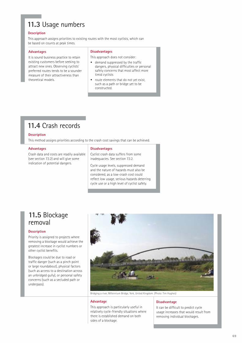
69
11.3 Usage numbersDescriptionThis approach assigns priorities to existing routes with the most cyclists, which can be based on counts at peak times.
AdvantagesIt is sound business practice to retain existing customers before seeking to attract new ones. Observing cyclists’ preferred routes tends to be a sounder measure of their attractiveness than theoretical models.
DisadvantagesThis approach does not consider:• demand suppressed by the traffi c
dangers, physical diffi culties or personal safety concerns that most affect more timid cyclists
• route elements that do not yet exist, such as a path or bridge yet to be constructed.
11.4 Crash recordsDescriptionThis method assigns priorities according to the crash cost savings that can be achieved.
AdvantagesCrash data and costs are readily available (see section 7.3.2) and will give some indication of potential dangers.
DisadvantagesCyclist crash data suffers from some inadequacies. See section 7.3.2.
Cycle usage levels, suppressed demand and the nature of hazards must also be considered, as a low-crash cost could refl ect low usage, serious hazards deterring cycle use or a high level of cyclist safety.
11.5 Blockage removalDescriptionPriority is assigned to projects where removing a blockage would achieve the greatest increase in cyclist numbers or other cyclist benefi ts.
Blockages could be due to road or traffi c danger (such as a pinch point or large roundabout), physical factors (such as access to a destination across an unbridged gully), or personal safety concerns (such as a secluded path or underpass).
AdvantageThis approach is particularly useful in relatively cycle-friendly situations where there is established demand on both sides of a blockage.
DisadvantageIt can be diffi cult to predict cycle usage increases that would result from removing individual blockages.
Bridging a river, Millennium Bridge, York, United Kingdom. (Photo: Tim Hughes)

70
11.9 RecommendationsSeveral criteria should be used together.
The cycle review or LOS criteria could usefully be combined with cycling usage data and cross-compared with crash data and project costs. Together, these may indicate a programme focus on a particular geographical area, bringing forward other lower-ranked projects and removing identifi ed blockages. This treatment could then be repeated for the next highest-ranked area, and so on.
This approach should not, however, neglect the value of some demonstrable achievement through implementing easy or cheap network elements or some quality fl agship projects. Similarly, a focus on a particular area should not neglect particularly strong needs identifi ed elsewhere.
During implementation, it may be useful to advance a lower-ranked cycling project and combine it with the timing of a mainstream project. See section 12.2.1.
11.6 Easiest or cheapest fi rstDescriptionThe easiest or cheapest elements in a programme are given priority.
AdvantagesA simple achievement measure, such as the total length of a cycle route meeting a certain LOS, gives an impression of achievement. This is useful when the value of a cycle route programme is questioned.
DisadvantagesThe easiest or cheapest elements are not always the most needed. The importance of the different elements also needs to be considered.
There is a risk that such a short-term approach will lead to lower-quality outcomes in the longer term.
11.7 Quality demonstration projectsDescriptionPriority is given to fl agship projects that showcase attractive, high-quality facilities that others will want to emulate in their own communities.
AdvantageThis can build community support for providing quality facilities of which they can be proud.
DisadvantageIt may be expensive and use up all the budget.
11.8 Area consolidationDescriptionThis gives priority to spreading cycle provision across a substantial area. Once a consistently high cyclist LOS has been consolidated in one discrete area, provision is spread to another.
AdvantagesConsolidation may increase cycling and be a more clearly demonstrable achievement.
If the whole area has achieved a satisfactory standard, cycling promotion can take place without undue concerns about an unsafe environment for cycling.
DisadvantageA focus on a single area over several years may lead to charges of inequitable treatment in relation to areas that do not enjoy this investment.

71

72
OPPORTUNITIES FOR IMPROVING PROVISIONS FOR CYCLISTS
Road marking after resealing.
Carriageway adjustments with kerb and channel replacement.
Shoulder widening as part of edge-break repairs or drainage improvements.
Railway, motorway and pipeline corridors.
Conservation land.
Using strategic properties that come up for sale for off-road facilities.
Co-ordinating with projects carried out by adjacent local authorities and Transit New Zealand.
Arterial road traffi c management — parking restrictions and crossing facilities.
Safety improvement works and intersection changes.
Traffi c signal upgrades — cycle-friendly detectors, signals and phasing, and lane arrangements.
Bus priority schemes — bus-bike lanes, head start signals.
Bridge replacement or widening.
Local area traffi c management schemes, including contra-fl ow lanes.
Safer Routes to Schools projects and school travel plans.
Improvements for pedestrians, such as barrier removal, crossings and footpath widening — include wider, shared paths.
Urban renewal projects.
Parks and reserves redevelopments.
Other developments by the local authority and others.
Riverfront and waterfront developments.
New subdivisions, including paths and links.
New commercial developments or redevelopments.
12.2 IntegrationCycle network planning needs to be integrated with mainstream transportation planning and policy. If not, confl icting policies and infrastructure provision can undermine its potential to achieve its objectives — for example, measures that increase the volume and speed of traffi c with which cyclists have to mix.
Providing for cyclists’ needs should be the responsibility of all departments or divisions of a local authority or road controlling authority, whether or not they have a cycling offi cer or unit.
This is because their decisions and activities have the potential to either help or hinder the satisfaction of cyclists’ needs. The task is too big to be the sole responsibility of one person or small specialist unit.
IMPLEMENT CYCLE NETWORK DEVELOPMENT
Allocate funding for detailed investigation, design and construction/implementation.
Detailed investigation and design of individual cycle projects.
Audit of individual cycle projects.
Physical works.
Maintenance.
12 IMPLEMENTATION
Table 12.1: Opportunities for improving provisions for cyclists
Source: Fundamentals of planning and design for cycling: Course notes: Version 01 (Transfund, New Zealand, 2003, p.55)
12.1 IntroductionThis section discusses implementing an agreed plan to improve cycle infrastructure in an area.

73
12.2.1 Infrastructure projects
Each local authority has forward work programmes identifying the infrastructure works to be implemented in the planning period, including road, path and bridge construction and maintenance (see Table 12.1).
A plan showing these infrastructure works should be superimposed on the cycle network plan to identify where the two sets of works overlap. Any desirable cyclist facilities should be incorporated in the mainstream infrastructure works rather than being retrofi tted at greater expense and possibly to a lesser standard later.
Also, cycle facilities can be provided as part of other infrastructure works (or maintenance) rather than being funded by a local council’s dedicated cycle facilities fund. This means the fund can be made to go further and the primary cycle route network can be achieved sooner.
Individual opportunities to incorporate cycling works with other programmed works are likely to be scattered around the network, which means fragmented facilities until the inter-linking portions are completed. This is unavoidable and acceptable as long as suitable transitions are designed. However, it is desirable to implement whole routes wherever possible as incomplete cycle facilities are likely to result in signifi cant cyclist dissatisfaction. Refer to section 13.4 for more information on monitoring programme implementation.
12.2.2 District plans
Include maps of the primary cycle route network in district plans, together with appropriate objectives, policies and rules relating to avoiding, remedying or mitigating the adverse effects of other activities on cycling, in a similar way to provisions for arterial roads. Mitigation measures could include, for example, off-street car parking provision to allow for cycle lanes, and private contributions towards implementing an adjacent section of the network.
12.3 Implementation programmes 12.3.1 Long-term programme
The long-term implementation programme, which needs to be fl exible, should record each project’s name, location, estimates of construction cost and professional fees, and proposed year of implementation.
The professional fees for investigation and design can be signifi cant compared with other roading projects.
For the purpose of integration, the cycle network implementation programme should have the same planning period as the local authority’s LTCCP.
Separate plans showing each stage of the work should be prepared. Such plans help identify and avoid any gaps in the network.
12.3.2 Short-term programme
A more precise one- to fi ve-year cycle network implementation programme should be prepared, based on the longer-term programme. This programme can feed into the local authority’s annual planning process.
12.4 Cycle network and programme review At least every fi ve years, the entire cycle network and implementation programme should be reassessed to confi rm its currency. Factors to consider include:• has the cycle network development
progressed as planned?• have cyclist desire lines or cycle route
usage changed? • has cyclist safety improved?• have there been signifi cant changes
to the district transport infrastructure or major land-use developments that require changes to the network plan?
• have cycle network and route design and planning practice changed?
• has the way that cycle projects are evaluated and funded changed?
• are there opportunities to complete gaps in the network that should be given a higher priority?
12.5 Detailed investigation and designThis step involves assessing individual cycling infrastructure projects in more detail than at the network planning stage, which may have been undertaken some years previously.
It may be appropriate to confi rm that the planned option is still the most appropriate. Refer to the earlier sections of this guide for details of these assessments.
12.6 AuditThe audit tools discussed in section 9.3 can be applied at scheme concept stage, to detailed design plans, and after construction.
12.6.1 Design audit
Before the detailed investigation and design are complete, plans should be audited to identify any design defi ciencies and to ensure that opportunities to improve cycling conditions are properly considered.

74
12.6.2 Post-construction inspection
When a cycle facility is complete, and preferably before it is opened for use, it should be inspected using a bicycle. The inspection aims to identify any defi ciencies that could compromise cyclists’ safety. Any remedial works considered necessary should be carried out as soon as possible and preferably before the facility is opened for use.
12.7 Personnel resourcesIt is essential that all personnel, including politicians, responsible for planning, implementing and promoting cycling facilities are available, appropriately trained and skilled and aware of the latest technical guidance and relevant research fi ndings. There also needs to be a wider understanding of cycling policy, its objectives and benefi ts. Specialist training should be undertaken where necessary (McClintock, 2002, pp32-33).
12.7.1 Cycling planners
Many projects in different administrations and organisations can affect cycling, and planning and implementing a cycle network involves a signifi cant amount of work.
For this reason, each RCA should have someone with overall responsibility for preparing and implementing its cycling strategic plan. Where large urban areas are involved this position should be full-time, and may need the support of other full-time staff dedicated to this function.
Those responsible for co-ordinating cycle provision need to have a high profi le within their organisations and be supported by senior management.
12.7.2 Cycling advocates
Cycling advocates, who often form groups to further their collective interests, can make a signifi cant contribution at most stages of the cycle network planning and implementation process. If there is no group in an area, the local authority could help establish one. However, it must be independent to remain effective.
Details of the consultation required at each step in the planning process are discussed in the relevant sections of this guide.
12.7.3 Cycling advisory groups
It is recommended that each local authority convene a cycling advisory group.
12.7.4 Consultants
There are consultants who specialise in cycle planning and cycle infrastructure design. Before engaging a consultant, check they have the specialist skills and experience relevant to the tasks required.
Experience in general roading or transport planning and design is not suffi cient on its own.
12.8 Maintenance‘To achieve adequate maintenance there need to be clear performance standards, and adequate staffi ng and revenue funding covering the maintenance of both on- and off-road cycle routes with reference to surface quality, signing, markings and cutting back intrusive vegetation. Regular inspection is vital as well as clear and well-publicised mechanisms for reporting defects’ (McClintock, 2002 p.30).
In York, United Kingdom, cycle-mounted maintenance rangers, each towing a trailer of tools, have been appointed to help improve cycle facility maintenance (Harrison, 2002, p.151).
In Odense, Denmark, four cyclists are equipped with cellphone cameras, with which they photograph defects, to send to the roads and parks maintenance offi cer with a text message description and location. They get paid for each accepted message.
Inspections and any necessary maintenance should be carried out after storms and during and after road works or property development that could result in detritus on the cycle route.
12.9 Funding for infrastructureLong-term investment in cycle infrastructure and promotion is needed to induce a signifi cant modal shift (Harrison, 2002, p.153).
RCAs fund cycling projects. Such funding must be provided for in LTCCPs and annual plans. Cycling projects that meet a transport need and satisfy the relevant criteria are eligible for a subsidy from Transfund New Zealand. Refer to Transfund’s Programme and funding manual and Project
evaluation manual for details of the criteria.
Community groups, community trust funds and tourism interests are potential alternative sources of labour or funding for recreational cycling routes.
Construction of cycle parking facilities also qualifi es for a Transfund New Zealand subsidy.
12.10 Funding for other initiativesThe central government responsibility for funding of non-infrastructure initiatives is not well defi ned. Activities that meet the requirements of Transfund NZ’s travel demand management category may be
subsidised by Transfund NZ. School road safety education funding is being reviewed.
Discuss your cycle safety education proposals with the nearest LTSA regional manager.
12.11 Timeframes and levels of fundingIt takes time to develop a well connected cycle network, and the annual expenditure will determine the rate at which this happens. It is unrealistic to expect a signifi cant increase in cycle use before signifi cant portions of the network are complete, not least because the cycle network is just one aspect of the overall provision cyclists require.
However, in the longer term, cities overseas have been able to improve cycle safety and increase cycling’s modal share. Consistent and continuing effort eventually achieves results.
12.12 Quality of cycle provisionDesign standards are often compromised because of space and fi nance constraints, resulting in substandard facilities that can sometimes put cyclists more at risk than if no provision were made at all.
Cycle paths are often not safe, convenient, attractive or direct. More attention needs to be given to the quality of initial design, construction and maintenance. Attention to detail is very important. Cyclists may avoid an otherwise adequate cycle route because of one particularly hazardous or inconvenient obstacle.
12.13 Publicising facilitiesCycling facilities need to be publicised and cycling promoted to maximise cycle use. These activities can include:• media releases to announce complete
routes or facilities• providing a cycle network map showing
cycle routes, cycle-friendly routes and cycle parking facilities
• providing network signage to indicate recommended cyclist routes.
Network signageHaving route and destination signage for cyclists is important in promoting facilities. Initially it will be necessary to plan signage for parts of the network that are complete.
Once erected, the signs should be recorded and managed using a signs inventory and asset management system.
Signage of cycle routes is eligible for a Transfund New Zealand subsidy.

75

76
13.2 Features to monitorThe following features should be monitored and included in an annual or biennial report on cycle network development:
Physical works programmes.
Cycle use and modal share.
Cycle crashes.
Satisfaction levels regarding cycle facilities.
Cycle facilities’ condition.
Cycle network implementation.
LOS improvements.
13.3 Pragmatic approachFor effi ciency purposes, monitoring and surveys of cycling should be integrated with similar local authority or RCA activities where possible.
13.4 Physical works programmesAs discussed in section 12.2.1, physical works programmes should be monitored to identify opportunities to include provisions for implementing sections of the cycle network, or for otherwise satisfying cyclists’ needs.
Planned general or reactive maintenance works (including storm damage repair) should be monitored on a monthly, or as appropriate, basis. Meanwhile, the infrastructure and maintenance works programme of Transit New Zealand and adjacent local authorities should be monitored at least annually.
13.5 Cycle useThe number of cyclists using key sections of the network should be counted annually to: • detect any changes in cycle use
that may affect cycle network implementation priorities
• collect data to support funding applications.
Installing continuous automated counters on key routes provides some control data for monitoring cycle use on the network. This can also be used for scaling short-term or seasonally affected counts and for calculating modal split.
Individual locations do not need to be counted every year. A rolling fi ve-year programme of cycle counts will be adequate for monitoring and design purposes.
Cyclists’ trip patterns are important clues to the effectiveness of cycle network planning. If these differ signifi cantly from those envisaged by network planners, it may indicate the need for a change of approach.
13.6 Cycle crashesCycle crash data should be monitored annually in order to detect:• any new or growing hazards that
may require urgent attention, or an adjustment to the cycle network implementation priorities
• any problems associated with recently completed cycle facilities
• whether cyclists’ safety is increasing or decreasing.
13.7 Satisfaction levelsA sample of all road users (including pedestrians) should be surveyed annually or biennially in order to identify the degree of satisfaction or dissatisfaction with provisions for cyclists in the study area. This survey is probably best included in a local authority’s residents’ survey, if it has one. A more specifi c survey of cyclists is also desirable.
13.8 Cycle facilities’ conditionThe condition of existing cycle facilities should be monitored and any necessary maintenance programmed and carried out.
A system for cyclists to report hazards could be implemented, for example by freepost reply cards, email, the internet or phone hotlines.
Some European towns pay cyclist advocacy groups to conduct regular condition surveys.
13 MONITORING13.1 IntroductionThis section describes the monitoring required, particularly once the implementation of the cycle network plan has started.

77
13.9 Cycle network implementation It is important for cycle network planning and maintenance purposes to maintain an up-to-date plan and schedule of the sections of the cycle network that have been implemented. From these, the percentage of the ultimate network completed can be calculated and compared with the planned progress, and reported where appropriate.
13.10 Level of serviceThe LOS of critical sections of the network (see section 9.5) can be monitored periodically to determine whether cycling conditions have deteriorated to an extent that upgrading should be given a higher priority.
13.11 BenchmarkingSeveral towns in Europe participate in benchmarking surveys to assess the adequacy of RCA policies and the performance of their networks in relation to the network attributes listed in Table 3.1.
These can be used to monitor progress in improving cycling conditions, and to compare network performance with other comparable centres that have taken part.
Bicycle Policy Audit (BYPAD), is offered by specialist consultants throughout Europe.
This process involves questionnaires completed by politicians, municipal offi cials and cyclists’ representatives. The auditor then facilitates the development of quality aims and measures for the future on the basis of the assessment results. More information is available at www.bypad.org
The Dutch Cyclists Union (Fietsersbond) also conducts benchmarking surveys called the Cycle Balance for the Dutch Government. This involves surveying cyclist representatives and the local authority’s offi cers. An instrumented bicycle is used to ride a sample of routes between randomly selected homes and common cyclist destinations. These are compared with car travel for the same trip. Cities are rated on their directness, delays to cyclists, road surface quality, noise levels, competitiveness with the car, bicycle modal share (for trips under 7.5 kms), bicycle injury rates, cyclist satisfaction and documented cycling policies. The project is described in Borgman (1993). The score table of 125 Dutch towns can be viewed on www.fi etsbalans.nl (Dutch language).
13.12 Plan reviewThe monitoring results should be assessed at least every three years and the cycle network plan and programme adjusted as appropriate. Whether the plan is yielding value for money should also be assessed.
Cycle balance diagram for Veelendaal, The Netherlands.

78
14.2 Why consult?Consultation underlies governance in a democratic society, and the Local Government Act 2002 emphasises a partnership with the community in everything local government does.
Also, most politicians and offi cials do not rely on cycling as everyday transport. This means they have no recent personal cycling experience on which to assess proposed cycling measures. In addition, consultation is a way of accessing cyclists’ extensive local cycling knowledge and experiences and identifying their, and potential cyclists’, attitudes.
14.3 What is consultation? Consultation may mean informing the community, or being informed by it, or both. It may range from informing the public and asking for their consent to the public owning the strategy formulation process and contributing their own perspectives.
Consultation is distinct from survey work or information gathering, which are controlled by cycle planners and essentially focus on factual data. Consultation, by contrast, seeks to give others a voice and to focus on views and perspectives contributed to the cycle planning process.
14.4 Who to consultCycle planning expertise frequently rests with a small group of specialists and cycling advocates. Strong dialogue is required with cycling advocacy groups and specialists to ensure this expertise is incorporated and to test the technical aspects of cycle planning. Cycling advocates will need to be informed by technical perspectives.
Because cyclists’ needs vary, a range of cyclist types will need to be consulted. Confi dent and less confi dent cyclists, those cycling longer distances (often at higher speeds), local commuters, school cyclists and those cycling for sport or leisure, should all be included.
Other transport stakeholder groups and the wider community will also need to be consulted on cycling-related proposals. These will include representatives of car drivers, truck operators, public transport
operators and users, and pedestrians. A balance will be frequently needed to ensure each group’s needs are appropriately met without unreasonably disregarding those of others.
14.5 When to consultConsultation is required throughout the cycle planning process (see Table 14.1).
It is important to consult when proposals are still at a formative stage. Although consultation is often seen as an extra expense, it is usually repaid many times over in avoiding inappropriate design and sometimes the need to retrofi t later.
14.6 How to consultThe requirement to consult is more important than the precise way in which consultation takes place. The following are some avenues that have been found useful. They are not exclusive, often needing to be used in combination:• Cycling working parties or advisory
groups, usually comprising technical and professional staff from a range of offi cial stakeholders (for example, local authority and Transit New Zealand, LTSA, New Zealand Police, and the regional council) along with cyclist representatives.
• Public workshops, open forums or focus groups.
• Formalised submission processes (for example on annual plans or LTCCPs).
• Public notices, letter-drops of proposals, and internet-based information and response opportunities.
• Cycle audit and cycle review processes (see section 9.4).
• One-on-one meetings with individual stakeholders as required, on specifi c subject matter.
• Cycling planners or champions employed by the RCA, whether full-time, part-time or incidental to another role, who can act as brokers between their employers and local advocates. Strong support to this role is important because otherwise impossible pressures may be generated by unrealistic expectations (especially if, as often is the case, the person is at a relatively junior position within the organisation). Professional ethical issues need to be recognised and this role needs to supplement, not replace, support for cycling across the wider organisation.
14 CONSULTATION14.1 IntroductionThis section describes the consultation that is appropriate at all stages of the planning process.
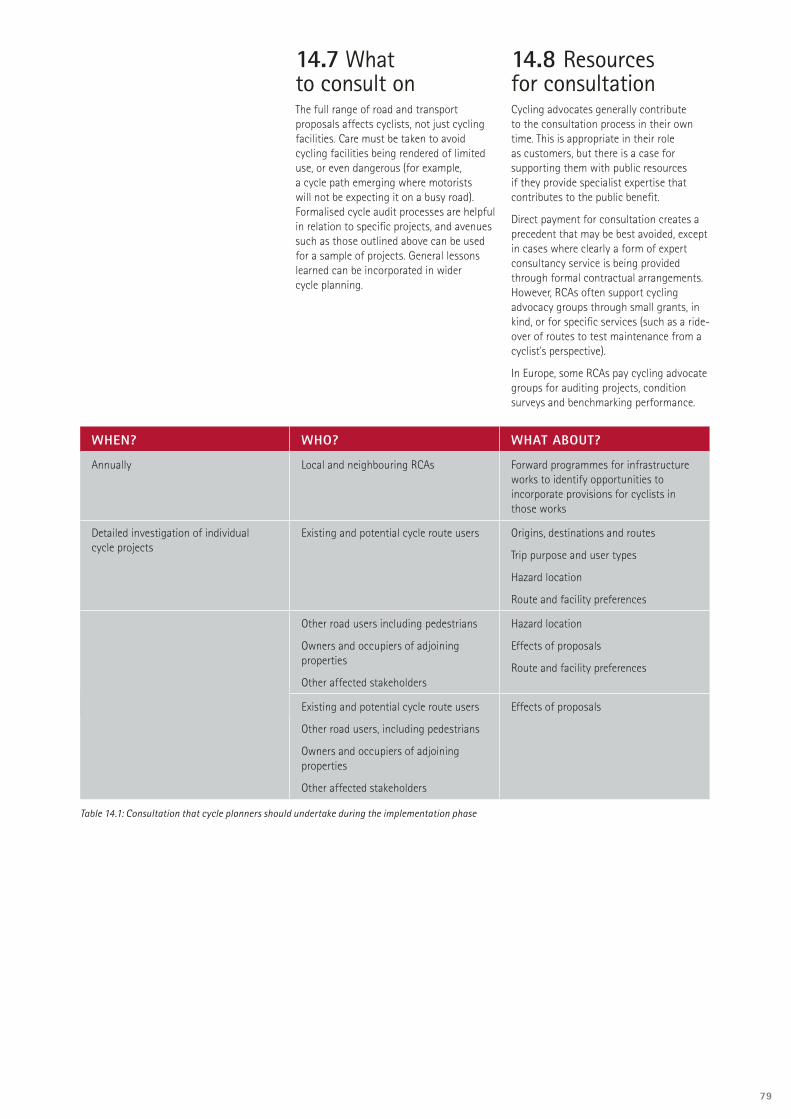
79
WHEN? WHO? WHAT ABOUT?
Annually Local and neighbouring RCAs Forward programmes for infrastructure works to identify opportunities to incorporate provisions for cyclists in those works
Detailed investigation of individual cycle projects
Existing and potential cycle route users Origins, destinations and routes
Trip purpose and user types
Hazard location
Route and facility preferences
Other road users including pedestrians
Owners and occupiers of adjoining properties
Other affected stakeholders
Hazard location
Effects of proposals
Route and facility preferences
Detailed design of individual cycle projects Existing and potential cycle route users
Other road users, including pedestrians
Owners and occupiers of adjoining properties
Other affected stakeholders
Effects of proposals
14.7 What to consult onThe full range of road and transport proposals affects cyclists, not just cycling facilities. Care must be taken to avoid cycling facilities being rendered of limited use, or even dangerous (for example, a cycle path emerging where motorists will not be expecting it on a busy road). Formalised cycle audit processes are helpful in relation to specifi c projects, and avenues such as those outlined above can be used for a sample of projects. General lessons learned can be incorporated in wider cycle planning.
14.8 Resources for consultationCycling advocates generally contribute to the consultation process in their own time. This is appropriate in their role as customers, but there is a case for supporting them with public resources if they provide specialist expertise that contributes to the public benefi t.
Direct payment for consultation creates a precedent that may be best avoided, except in cases where clearly a form of expert consultancy service is being provided through formal contractual arrangements. However, RCAs often support cycling advocacy groups through small grants, in kind, or for specifi c services (such as a ride-over of routes to test maintenance from a cyclist’s perspective).
In Europe, some RCAs pay cycling advocate groups for auditing projects, condition surveys and benchmarking performance.
Table 14.1: Consultation that cycle planners should undertake during the implementation phase

80
CYCLING STRATEGIC PLANS
A1.1 Policy context
An outline of the relevant broader policies and strategies, which often contain the justifi cation for preparing the cycling strategic plan (see chapter 2).
A1.2 Authorship and participation
A local authority or regional council usually authors a cycling strategy. However, other appropriate agencies should be closely involved and agree to any content that they are responsible for implementing. Other agencies include Transit New Zealand, local councils (regional/city/district), the LTSA, Transfund New Zealand and the New Zealand Police. Local cycling advocacy group(s), other road user groups, employers and cycle retailers will also need to be consulted.
A1.3 Cycling policy objectives
Brief statements setting out, in general terms, what is intended to be achieved.
A1.4 Targets
Targets against which achievement is measured could include: • cycle use and modal share• cyclist injuries and hospitalisations• satisfaction levels regarding cycle
facilities • cycle facilities’ condition• cycle network implementation• LOS improvements• the proportion of school pupils trained
to basic competence each year.
A1.5 Actions
These will include both engineering and non-engineering actions. They will tend to be in generalised terms within the cycling strategic plans, and where necessary supplemented by other documents specifying the requirements. Typical elements include:• cycle route network planning and
implementation (the subject of this guide)
• educating cyclists in road rules, bicycle maintenance, safety precautions and practical skills in relation to other traffi c
• educating motorists and pedestrians on the cyclists’ needs and likely behaviour
• educating cyclists and pedestrians on safe path sharing
• enforcing correct and appropriate behaviour by motorists and cyclists
• measures to overcome perceived negative aspects of cycling
• measures that integrate cycling with travel behaviour change programmes
• crash reduction studies focusing on cycle crash patterns
• measures to integrate cycling with public transport, such as secure parking at stations and cycle carriage on buses
• a cycle parking strategy and implementation programme (covering different types of parking demand)
• recommended actions by non-RCA agencies (for example, Police, regional council, schools, employers), sometimes with funding assistance
• an outline of the sources and roles of funding for implementation of the cycling strategic plan
• incorporating the network and any associated rules into the district plan
• a programme of signs for cycling facilities.
A1.6 Cycling data
The data needed to plan and implement the cycling strategic plan, including cycling usage and crash data.
A1.7 Liaison channels
An outline of the formal channels and processes (for example, cycling advisory group) by which politicians, offi cials (both within the RCA and between it and other governmental bodies) and cycling advocacy groups are consulted and involved in progressing the cycling strategic plan.
A1.8 Cycling engineering standards
An endorsement of Austroads’ Guide to
traffi c engineering practice: Part 14: Bicycles as amended by the New Zealand Cycling design supplement, with allowance for local variations.
A1.9 Cycle route network prioritisation criteria
A statement of how priorities are set for implementing cycling infrastructure projects.
A1.10 Cycle network plan
A map of the proposed network.
The timeframe and proposed investment by which the entire cycle route network will be implemented. This should include a general staged programme and description of the
geographical areas and particular needs or problems that will be tackled.
A1.11 Short-term cycling route network implementation programme
A description of projects and detailed costings for the next three years of the cycle route network implementation programme. Costings should preferably be based on the outcome of formal project feasibility studies. On fi rst adoption of a cycling strategic plan, the outcomes of such studies may not be available; in this case these elements should be incorporated in the cycling strategic plan at its fi rst review.
A1.12 Review period
The term after which the cycling strategic plan will be reviewed. This will often be three years, but should align with the review periods and timings of other relevant RCA documents (such as LTCCPs).
A1.13 Monitoring indicators
Progress towards targets as measured by appropriate indicators should be included in an annual report. For a discussion on these see sections 13.5—13.10. In addition to these measures, the reach and effectiveness of cycling promotions and the number of school students that pass the basic competence road test following school cycle education could be monitored.
A1.14 For more information
A generic cycle strategic plan is available from the Environment Canterbury website www.ecan.govt.nz .
A discussion of the range of policies needed to support cycling is provided in Koorey, 2003.
APPENDIX 1
This appendix describes the elements that should be included in a cycling strategic plan (note other terms may be used such as bike plan and cycling strategy).

81
APPENDIX 2SCALING CYCLE COUNTSIntroductionThe number of cyclists using a facility varies by time of day, day of the week and week of the year. Based on some Christchurch cycle counts described below, the variation over an average weekday is shown in Figure A2.1. The variation in weekly fl ows across one year is shown in Figure A2.2. The purpose of this appendix is to recommend a procedure for estimating the average annual daily fl ow of cyclists (cycling AADT) from cycle counts conducted at one time. It is not normally practical to count cyclists over a whole year. A formula for scaling up short-period cycle counts is described below.
Scaling factorsThe scale factors in Tables A2.1 to A2.3 are based on year-round continuous cycle counts from 13 cycle loops around Christchurch. If an adequate set of continuous count data is available for the local area concerned it should be used instead. (A programme for collecting and updating such data for each area is recommended elsewhere in this guide.) The scale factors account for the time of day (H), day of the week (D), and week of the year (W). The week factor varies with school holidays and season. The pattern was found to vary depending on the presence of cyclists riding to and from school. The presence of school cyclists is shown by a peak after 3 pm (see Figure A2.1) that is absent from work commuting. The amount of school cycling at the site also affects the extent of the drop in cycling during school holidays. For this reason there are two sets of factors in the tables to provide for situations with and without school cycle traffi c.
Figure A2.1 Weekday daily cycling count profi le corresponding to H-weekday for all sites in Table A2.1.
Figure A2.2 Profi le of weekly cycling counts corresponding to W-all in Table A2.3.

82
Calculation equationThe following equation yields the best estimate of a cycling AADT:
where Count = result of count period
H = scale factor for time of day
D = scale factor for day of week
W = scale factor for week of year
If cycle count data for more than one day is available, then the calculation should be carried out for each day, and the results averaged.
Worked exampleSuppose two counts (of 90 and 165 minutes respectively) have been undertaken on weekdays in May. The site is used by both school children and commuters. The count data and the coeffi cients to be used are shown in the table below, as well as the AADT estimates resulting from the two counts.
Averaging the estimates yields a cycling AADT of 396.
RecommendationsWe recommend using the above equation for approximating the cycling AADT. As cycling volumes fl uctuate from day to day depending on the weather, this method should be used with caution, and ideally the estimate should be achieved based on the average of the results of several counts. Individual counts should be for periods of no less than 60 minutes. Counts should be of cyclists in both directions and cover at least the morning peak period, the after school hour and the evening commuter peak. Counts during warmer months and school terms will provide the most reliable estimates. Also take note of tertiary calendars when planning counts. It is not appropriate to scale up counts from Christmas/New Year holidays.
Use the Christchurch data in the absence of better local information, but take into account any demonstrable local factors. While the data has limitations, being from a limited number of sites in Christchurch only, it is now possible for the fi rst time to scale up cycle count data with some confi dence.
AcknowledgementThe method was developed by Axel Wilke of Christchurch City Council, building on work by Aaron Roozenburg (Beca Christchurch) in preparing data and undertaking some of the analysis. A fuller description of how the method was derived is available for Axel Wilke at Christchurch City Council. As more data is collected and the fi gures are refi ned, updated tables will be published.
AM COUNT PM COUNT
TIME 7.30 to 9.00 3.00 to 5.45
CYCLISTS 125 127
DATE 29-May-03 30-May-03
DAY Thursday Friday
H 25.5% 30.6%
D 16.8% 15.2%
W 0.98 0.98
AADT ESTIMATE 410 382
AADTCyc
= Count * 1 * 1 * W×H D 7

83
PERIOD STARTING
PERIOD ENDING
ALL SITES COMMUTER SITES
H WEEKDAY
MON TO FRIH WEEKEND
SAT & SUNH WEEKDAY
MON TO FRIH WEEKEND
SAT & SUN
0:00 7:30 4.8% 5.3% 7.8% 12.7%
7:30 7:45 2.0% 0.5% 1.9% 0.5%
7:45 8:00 3.1% 0.6% 2.5% 0.5%
8:00 8:15 3.0% 0.5% 2.5% 0.5%
8:15 8:30 4.9% 0.7% 2.6% 0.5%
8:30 8:45 7.8% 1.1% 3.1% 1.0%
8:45 9:00 4.7% 1.2% 2.0% 1.0%
9:00 10:00 5.1% 5.2% 4.9% 4.2%
10:00 11:00 3.1% 7.5% 3.4% 6.0%
11:00 12:00 3.1% 8.3% 3.8% 6.8%
12:00 13:00 3.5% 8.5% 4.6% 8.2%
13:00 14:00 3.5% 8.5% 4.5% 8.0%
14:00 14:15 0.9% 2.7% 1.1% 1.6%
14:15 14:30 1.0% 2.2% 1.2% 1.7%
14:30 14:45 1.6% 2.4% 1.4% 1.8%
14:45 15:00 1.5% 2.4% 1.4% 1.7%
15:00 15:15 1.5% 2.8% 2.0% 1.7%
15:15 15:30 1.9% 2.7% 1.8% 2.0%
15:30 15:45 4.7% 2.8% 1.9% 2.0%
15:45 16:00 3.3% 2.9% 1.9% 2.3%
16:00 16:15 2.2% 2.5% 2.2% 2.2%
16:15 16:30 2.2% 2.7% 2.2% 2.1%
16:30 16:45 2.2% 2.8% 2.5% 2.0%
16:45 17:00 2.3% 2.7% 2.9% 2.0%
17:00 17:15 3.1% 2.2% 3.8% 1.9%
17:15 17:30 3.5% 1.8% 4.3% 1.6%
17:30 17:45 3.7% 1.8% 4.6% 1.7%
17:45 18:00 2.8% 1.4% 4.0% 1.4%
18:00 19:00 5.7% 4.5% 7.4% 5.9%
19:00 20:00 2.7% 2.8% 3.2% 3.9%
20:00 0:00 4.6% 6.0% 6.4% 10.4%
Table A2.1 Typical daily cycling profi le.
DAY D ALL % D COMMUTE %
MONDAY 17.1% 16.1%
TUESDAY 16.4% 16.6%
WEDNESDAY 16.5% 16.7%
THURSDAY 16.8% 17.0%
FRIDAY 15.2% 16.3%
SATURDAY 9.0% 9.9%
SUNDAY 9.0% 7.4%
SECONDARY SCHOOL PERIOD
W ALL (FACTOR)
W COMMUTE (FACTOR)
SUMMER HOLIDAYS 1.13 1.02
TERM 1 0.78 0.84
APRIL HOLIDAYS 1.17 0.97
TERM 2 0.98 1.04
JULY HOLIDAYS 1.74 1.40
TERM 3 1.22 1.19
SEPT/OCT HOLIDAYS 1.42 1.24
TERM 4 0.91 0.93
Table A2.2 Weekday usage percentages. Table A2.3 Period adjustment factors.

84
APPENDIX 3SAMPLE QUESTIONNAIRE

85
Source: Kindly made available by Kym Dorrestyn, Dorrestyn & Co Pty Ltd.

86
Austroads (1999) Guide to traffi c
engineering practice: Part 14: Bicycles,
Austroads, Sydney, Australia.
Bach, B and Diepens, J (2000) International
handbook for user-group based bikeway
design, Technical University of Delft, Delft, The Netherlands.
Bach, B and Pressman, N (1992) Cycle Planning and the Northern Climate. In The bicycle: Global perspectives,
Proceedings of the Conference Velo
Mondiale, Montreal, Canada.
Bicycle Victoria (1996) It can be done
— a bicycle network on arterial roads,
Melbourne, Australia.
Borgman, F (2003) The cycle balance: benchmarking local cycling conditions, Chapter 40 in Tolley R (ed) Sustaining
sustainable transport: planning for walking
and cycling in western cities, Woodhead Publishing Ltd, Cambridge, United Kingdom.
Boulter, R (2000) New Zealand Cycling
Strategy Foundation Project: Interim
position statement. Available from Roger Boulter.
Centre for Research and Contract Standardization in Civil and Traffi c Engineering (CROW) (1993) Sign up for the
bike: Design manual for a cycle-friendly
infrastructure, CROW, Ede, The Netherlands.
Crossing, H (1987) The child cyclist, State Bicycle Committee of New South Wales, Traffi c Authority of New South Wales, Australia.
Cumming, A (1996) Prioritising the implementation of Melbourne’s principal bicycle network. In Proceedings of Velo
Australis International Bicycle Conference, pp 579—584, Fremantle, Australia.
Cumming, Barber, Smithers (1999) Planning and implementing on-road bicycle networks. In Proceedings of Velozity
Australian Cycling Conference 1999, Adelaide, Australia.
DELG (1999) Provision of cycle facilities
— National manual for urban areas,
Department of the Environment and Local Government, Dublin, Ireland.
Dorrestyn and Co (1995) Adelaide City
Strategic Bike Plan, Adelaide City Council, Adelaide, Australia.
Dorrestyn, K (1996a) Metropolitan Adelaide Bicycle Network. In Proceedings of Velo
Australis International Bicycle Conference, pp 585—594, Fremantle, Australia.
Dorrestyn, K (1996b) Planning for bicycles
in central business districts, ITE Regional Conference: Transport and Livable Cities, May 1996, Melbourne, Australia.
Epperson, B (1994) Evaluating suitability of roadways for bicycle use: Toward a cycling level of service standard. In Transportation
Research Record 1438, pp 9—16, Transportation Research Board, Washington DC, United States of America.
Faghri, A and Egyhaziova, E (2001) Development of a computer simulation model of mixed motor vehicle and bicycle traffi c on urban road network. In Transportation Research Record 1674, pp 86—93. Transportation Research Board, Washington DC, United States of America.
FGSV (1995) Empfehlungen für
Radverkehrsanlagen (Guidelines
for Bicycle Traffi c Installations), Forschungsgesellschaft für Strassen — und Verkehrswesen, FGSV Verlag GmbH, Cologne, Germany.
FHWA (1999) Guidebook on methods to
estimate non-motorized travel, FHWA-RD-
98-165, Federal Highway Administration, United States of America. Available in 2 parts plus summary plus workshop summary from www.bicyclinginfo.org/rd/planning.htm#guide
FHWA (1998) The bicycle compatibility
index: a level of service concept (2 parts)
fi nal report and implementation manual,
FHWA-RD-00-095, Federal Highway Administration and National Highway Traffi c Safety Administration, United States of America.
Florida DOT (2002) Multi-modal level of service assessment, handbook and software. Available from www.dot.state.fl .us/planning/systems/sm/los/los_sw2.htm
Franklin, J (1997) Cyclecraft: skilled cycling
techniques for adults, The Stationery Offi ce, London, United Kingdom.
Franklin, J (1999) Two decades of the redway cycle paths in Milton Keynes. In Traffi c Engineering and Control, July/August 1999.
Geelong Bikeplan Study Steering Committee (1977) Geelong Bikeplan, Geelong Regional Commission, Victoria, Australia.
Godefrooij, T (1992) Criteria for segregation and Integration of different modes of transport. In The Bicycle: Global
perspectives, Proceedings of the Conference
Velo Mondiale, Montreal, Canada.
APPENDIX 4BIBLIOGRAPHY

87
Guthrie, N; Davies, DG and Gardner, G (2001) Cyclists’ assessment of road and traffi c
conditions: the development of a cyclability
index. TRL Report 490, Transport Research Laboratory, United Kingdom.
Harrison, J (2002) Planning for more cycling: the York experience bucks the trend. In Planning for cycling: Principles,
practice and solutions for urban planners, pp 143—154, Woodhead Publishing Ltd, Cambridge, United Kingdom.
Hillman, M and Grimshaw, J (2000) Joint keynote presentation. In Proceedings of
the New Zealand Cycling Symposium 2000
‘Making cycling viable’, EECA, Palmerston North, New Zealand.
Hudson, M (1982) Bicycle planning: Policy
and practice, The Architectural Press Ltd, London, United Kingdom.
Hunter, W (1998) Bicycle compatible
roadways. A study of bicycle lanes versus
wide curb lanes. Highway Safety Research Center, University of North Carolina, United States of America.
Institution of Highways and Transportation, Cyclists’ Touring Club, Bicycle Association, and Department of Transport (1996) Cycle
friendly infrastructure: Guidelines for
planning and design, Cyclists’ Touring Club, Godalming, United Kingdom.
Institution of Highways and Transportation; Department of the Environment, Transport and the Regions; Scottish Offi ce; Department of the Environment for Northern Ireland; Welsh Offi ce (IHT et al) (1998) Guidelines
for cycle audit and cycle review, PTRC Education and Research Services Ltd, London, United Kingdom.
International Mountain Bicycling Association (2000) Trail building basics, Boulder, Colorado, United States of America.
Jacobsen, P L (2003) Safety in numbers: More walkers and bicyclists, safer walking and bicycling. In Injury prevention 9, pp 205—209.
Jensen, S and Nielsen, M (1996) Cycle
crossings — safety impacts at signalised
junctions, Report 51, Vejdirektoratet, Denmark.
Jensen, S et al (2000) Collection of cycle
concepts, Retrieved 14 June 2003, from www.cities-for-cyclists.org/dokumenter/cyccon.pdf
Katz, R (2001) Forecasting demand for
bicycle facilities, Austroads Report No.
AP-R194/01, Sydney, Australia. Available at www.abc.dotars.gov.au/418_AP_R194_1.pdf
Koorey, G (2004) Every breath you take, Chainlinks Feb — Mar 2004, pp 38—40, New Zealand, from www.can.org.nz/research/
Koorey, G (2003) Why a cycling strategy
on its own will not increase cycling. New Zealand Cycling Conference 2003, from www.can.org.nz , technical presentation papers.
Landis, B W; Vattikuti, V R; Brannick, M T (1997) Real-time human perceptions:
Toward a bicycle level of service,
Transportation Research Record
1578, Transportation Research Board, Washington, DC, United States of America.
Landis, B W; Vattikuti, V R; Ottenberg, R M; Petritsch, T A; Guttenplan, M; Crider, L B (2003) Intersection level of service for the
bicycle through movement, Transportation
Research Record 1828, Transportation Research Board, Washington, DC, United States of America.
Land Transport Safety Authority (2000) New Zealand Travel Survey 1997/98. Land Transport Authority, Wellington, New Zealand. Retrieved 8 September 2003 from www.ltsa.govt.nz/research/travel-survey/documents/Contents.pdf
Lester, N (1991) in McClintock, H The bicycle
and city traffi c, Belhaven Press, London, United Kingdom.
Litman, T; Blair, R; Demopoulos, B et al (2003) Pedestrian and bicycle planning:
A guide to best practice, Victoria Transport Policy Institute, Victoria, Canada.
McClintock, H and Cleary, J (1996) Cycle facilities and cyclists’ safety: Experience from Greater Nottingham and lessons for future cycling provision. In Transport Policy,
3, 1—2, 01/04, pp 67—77.
McClintock, H (2002) The development of UK cycling policy. In Planning for cycling:
Principles, practice and solutions for urban
planners, pp 17—35, Woodhead Publishing Ltd, Cambridge, United Kingdom.
McInerney, R (1998) Ranking procedures for bicycle projects. In Proceedings of 19th
ARRB Transport Research Conference,
Sydney, Australia.
Ministry of Transport (2003) Getting there —
on foot, by cycle. Draft walking and cycling strategy, Wellington, New Zealand.
MTPW and WM (1992) Bicycles fi rst.
Structured scheme for traffi c and transport,
Information Department, Ministry of Transport, Public Works and Water Management, The Netherlands.
New Zealand Government (2002) New Zealand Transport Strategy.
www.beehive.govt.nz\nzts
Opus International Consultants Ltd (Opus) (2003) Cycle network and route planning:
Literature review, Land Transport Safety Authority, Christchurch, New Zealand.
Ove Arup and Partners (1997) The national
cycle network: Guidelines and practical
details. Issue 2. Sustrans, Bristol, United Kingdom.
Roads and Traffi c Authority, NSW (RTA NSW) (2003) NSW bicycle guidelines, Roads and Traffi c Authority NSW, Sydney, Australia.
Scottish Executive (1999) Cycling by
design — a consultation paper — December
1999, The Stationery Offi ce, London, United Kingdom.
Sorton, A and Walsh, T (1994) Bicycle
stress level as a tool to evaluate urban
and suburban bicycle compatibility,
Transportation Research Record 1438,
Transportation Research Board, Washington DC, United States of America.
Sykes, R and Driscoll, T W (1996) Creating
bicycle transportation networks: A
guidebook, Minnesota Department of Transportation, St Paul, Minnesota, United States of America.
Taylor, S and Damen, P (2001) Traffi c fl ow
models allowing for pedestrians and
cyclists, Austroads Publication No. AP-
R193/01, Austroads, Sydney, Australia.
Transfund New Zealand (2002) Evaluation of
automatic bicycle counters in New Zealand,
Transfund New Zealand Research Report
230, Transfund New Zealand, Wellington, New Zealand.
Transfund New Zealand (2003) Fundamentals
of planning and design for cycling: Course
notes: Version 01, June 2003, Transfund New Zealand, Wellington, New Zealand.
Transfund New Zealand (1996 and updates) Programme and funding manual, Transfund New Zealand, Wellington, New Zealand.
Transfund New Zealand (1997) Project
evaluation manual, Transfund New Zealand, Wellington, New Zealand.
Transit New Zealand (2004) New Zealand
supplement to Austroads Guide to traffi c
engineering practice: Part 14: Bicycles,
Transit New Zealand, Wellington, New Zealand.
Transit New Zealand (2002) Code of practice
for temporary traffi c management, SP/
M/010 — Issue 2, Transit New Zealand, Wellington, New Zealand.
Transit New Zealand/Land Transport Safety Authority (Edition 4, 1998 with amendments) Manual of traffi c signs
and markings: Part 1: Traffi c signs, Transit New Zealand and Land Safety Authority, Wellington, New Zealand.
Transit New Zealand/Land Transport Safety Authority (Edition 3, 2004) Manual of traffi c
signs and markings: Part 2: Road markings, Transit New Zealand and Land Transport Safety Authority, Wellington, New Zealand.

88
Trevelyan, P (1993) Cycling in pedestrian
areas: Traffi c advisory leafl et, Transport Research Laboratory, United Kingdom.
United Kingdom Government Department for Transport (1995) Cycle routes, Department for Transport, United Kingdom.
United Kingdom Government (1963) Traffi c in
towns, HMSO, United Kingdom.
Vicroads (2001) Providing for cyclists at
signalised intersections, Vicroads Cycle
Notes, No.8, Victoria, Australia.
Walkable Communities Inc Bicycling
— levels of quality. Retrieved 17 September 2003 from www.walkable.org/images/1_LOQBicycling.jpg
Wood, K (1999) Bicycle crashes in
New Zealand, Lincoln University, Christchurch, New Zealand.