Embed Size (px)
Citation preview
Current Watches and Warnings
A Hurricane Warning is in effect for Grand Bahama and the Abacos Islands in the northwestern
Bahamas; Jupiter Inlet to Ponte Vedra Beach, FL
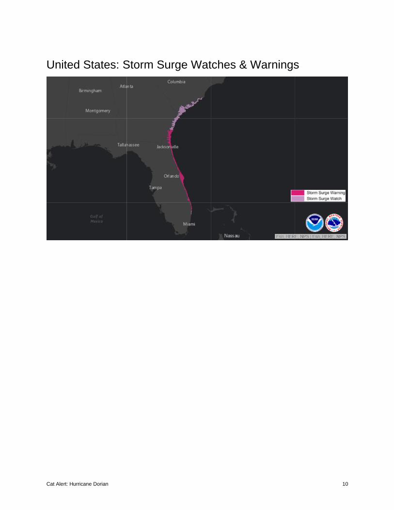
A Storm Surge Warning is in effect from Lantana, FL to Altamaha Sound, GA
A Hurricane Watch is in effect from north of Deerfield Beach to Jupiter Inlet, FL; north of Ponte Vedra
Beach to South Santee River, SC
A Storm Surge Watch is in effect from north of Deerfield Beach to south of Lantana, FL; Altamaha Sound,
GA to South Santee River, SC
A Tropical Storm Warning is in effect from north of Deerfield Beach to Jupiter Inlet, FL
A Tropical Storm Watch is in effect from north of Golden Beach to Deerfield Beach, FL; Lake
Okeechobee
Current Details from the National Hurricane Center (NHC)
COORDINATES: 26.8° north, 78.4° west
LOCATION: 25 miles (40 kilometers) northeast of Freeport, Grand Bahama Island
MOVEMENT: Stationary
WINDS: 145 mph (230 kph) with gusts to 170 mph (275 kph)
RADIUS OF TROPICAL STORM-FORCE WINDS: 150 miles (240kilometers)
RADIUS OF HURRICANE-FORCE WINDS: 45 miles (75 kilometers)
MINIMUM CENTRAL PRESSURE: 940 millibars
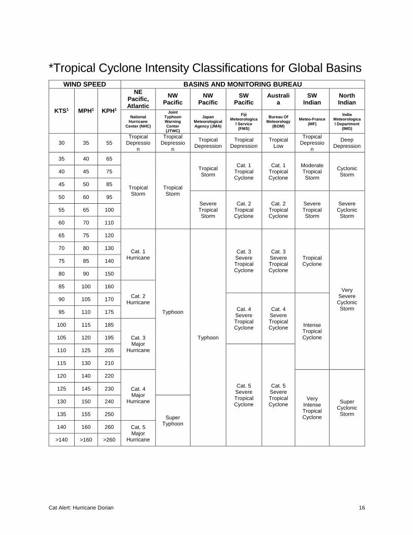
SAFFIR-SIMPSON SCALE RANKING*: Category 4
1st LANDFALL LOCATION: Elbow Cay, Abaco Islands, Bahamas
1st LANDFALL TIMEFRAME: approximately 12:45 PM local time (16:45 UTC) September 1
1st LANDFALL INTENSITY: 185 mph (295 kph) – Category 5*
*Tied the 1935 Labor Day Hurricane as the strongest hurricane on record to make landfall in the Atlantic Ocean
24-HOUR LANDFALL POTENTIAL: HIGH
Cat Alert: Hurricane Dorian 2
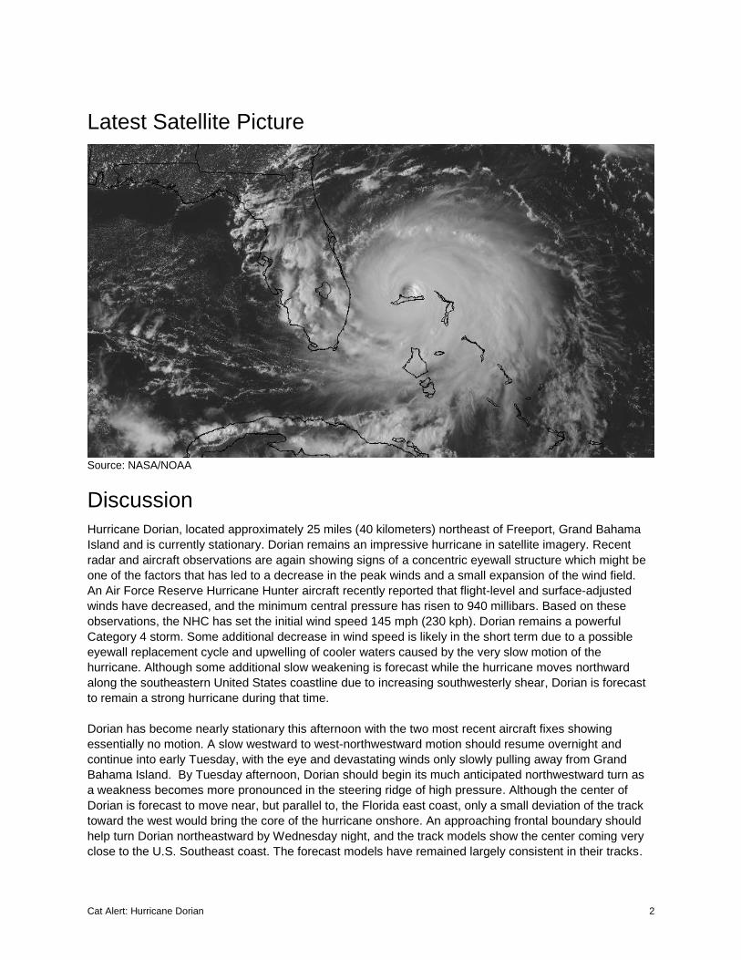
Latest Satellite Picture
Source: NASA/NOAA
Discussion
Hurricane Dorian, located approximately 25 miles (40 kilometers) northeast of Freeport, Grand Bahama
Island and is currently stationary. Dorian remains an impressive hurricane in satellite imagery. Recent
radar and aircraft observations are again showing signs of a concentric eyewall structure which might be
one of the factors that has led to a decrease in the peak winds and a small expansion of the wind field.
An Air Force Reserve Hurricane Hunter aircraft recently reported that flight-level and surface-adjusted
winds have decreased, and the minimum central pressure has risen to 940 millibars. Based on these
observations, the NHC has set the initial wind speed 145 mph (230 kph). Dorian remains a powerful
Category 4 storm. Some additional decrease in wind speed is likely in the short term due to a possible
eyewall replacement cycle and upwelling of cooler waters caused by the very slow motion of the
hurricane. Although some additional slow weakening is forecast while the hurricane moves northward
along the southeastern United States coastline due to increasing southwesterly shear, Dorian is forecast
to remain a strong hurricane during that time.
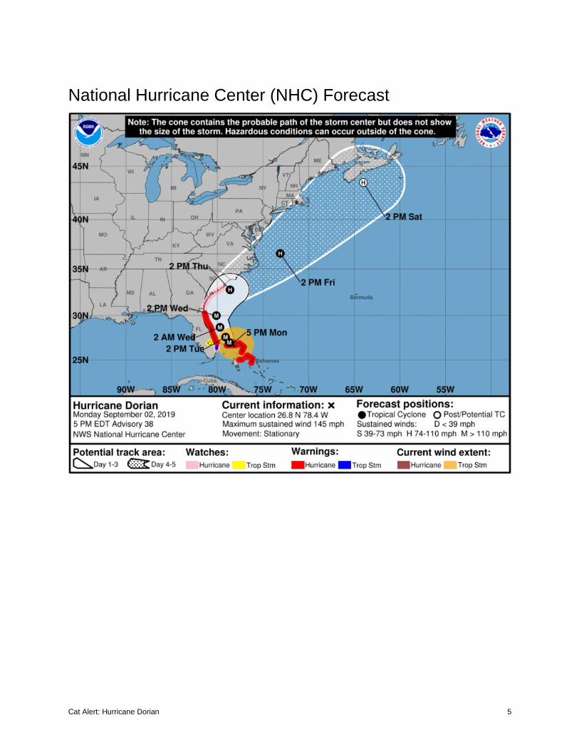
Dorian has become nearly stationary this afternoon with the two most recent aircraft fixes showing
essentially no motion. A slow westward to west-northwestward motion should resume overnight and
continue into early Tuesday, with the eye and devastating winds only slowly pulling away from Grand
Bahama Island. By Tuesday afternoon, Dorian should begin its much anticipated northwestward turn as
a weakness becomes more pronounced in the steering ridge of high pressure. Although the center of
Dorian is forecast to move near, but parallel to, the Florida east coast, only a small deviation of the track
toward the west would bring the core of the hurricane onshore. An approaching frontal boundary should
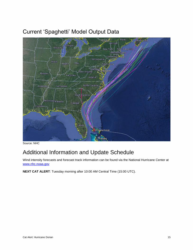
help turn Dorian northeastward by Wednesday night, and the track models show the center coming very
close to the U.S. Southeast coast. The forecast models have remained largely consistent in their tracks.
Cat Alert: Hurricane Dorian 3
Users are reminded that the hurricane is not a point, and that life-threatening storm surge and hurricane-
force winds extend far from the center. Regardless of the exact forecast track, strong winds and a life-
threatening storm surge are likely along a portion of the U.S east coast from Florida through the
Carolinas.
Key Messages from the National Hurricane Center
1. Devastating winds and storm surge will continue to affect Grand Bahama Island through tonight.
Everyone there should remain in shelter and not venture into the eye.
2. Life-threatening storm surge and dangerous hurricane-force winds are expected along portions of the
Florida east coast and the coasts of Georgia and South Carolina, regardless of the exact track of Dorian's
center. Water levels could begin to rise well in advance of the arrival of strong winds. Residents in these
areas should follow advice given by local emergency officials.
3. The risk of life-threatening storm surge and hurricane-force winds continues to increase along the
coast North Carolina. Residents in these areas should follow advice given by local emergency officials.
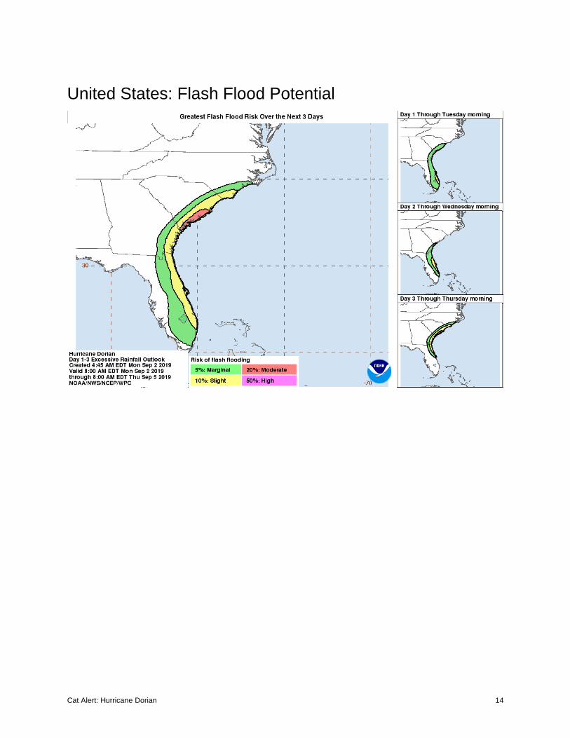
4. Heavy rains, capable of producing life-threatening flash floods, are expected over northern portions of
the Bahamas and coastal sections of the southeast and lower mid-Atlantic regions of the United States
through Friday.
Additional Information
WIND: Devastating hurricane conditions continue on Grand Bahama Island. Do not venture out into the
eye, as winds will suddenly increase after the eye passes.
Hurricane conditions are expected within the Hurricane Warning area in Florida by Tuesday. Hurricane
conditions are possible in the Hurricane Watch area beginning Wednesday.
Tropical storm conditions are expected within the Tropical Storm Warning area through Tuesday and are
possible in the Tropical Storm Watch area by tonight.
STORM SURGE: A life-threatening storm surge will raise water levels by as much as 12 to 18 feet above
normal tide levels in areas of onshore winds on Grand Bahama Island. Near the coast, the surge will be
accompanied by large and destructive waves. Water levels should very slowly subside on the Abaco
Islands during the day.
The combination of a dangerous storm surge and the tide will cause normally dry areas near the coast to
be flooded by rising waters moving inland from the shoreline. The water could reach the following heights
above ground somewhere in the indicated areas if the peak surge occurs at the time of high tide:
Lantana to South Santee River: 4 to 7 feet
North of Deerfield Beach to Lantana: 2 to 4 feet
Water levels could begin rise well in advance of the arrival of strong winds. The surge will be
accompanied by large and destructive waves. Surge-related flooding depends on the how close the
center of Dorian comes to the coast and can vary greatly over short distances.
Cat Alert: Hurricane Dorian 4
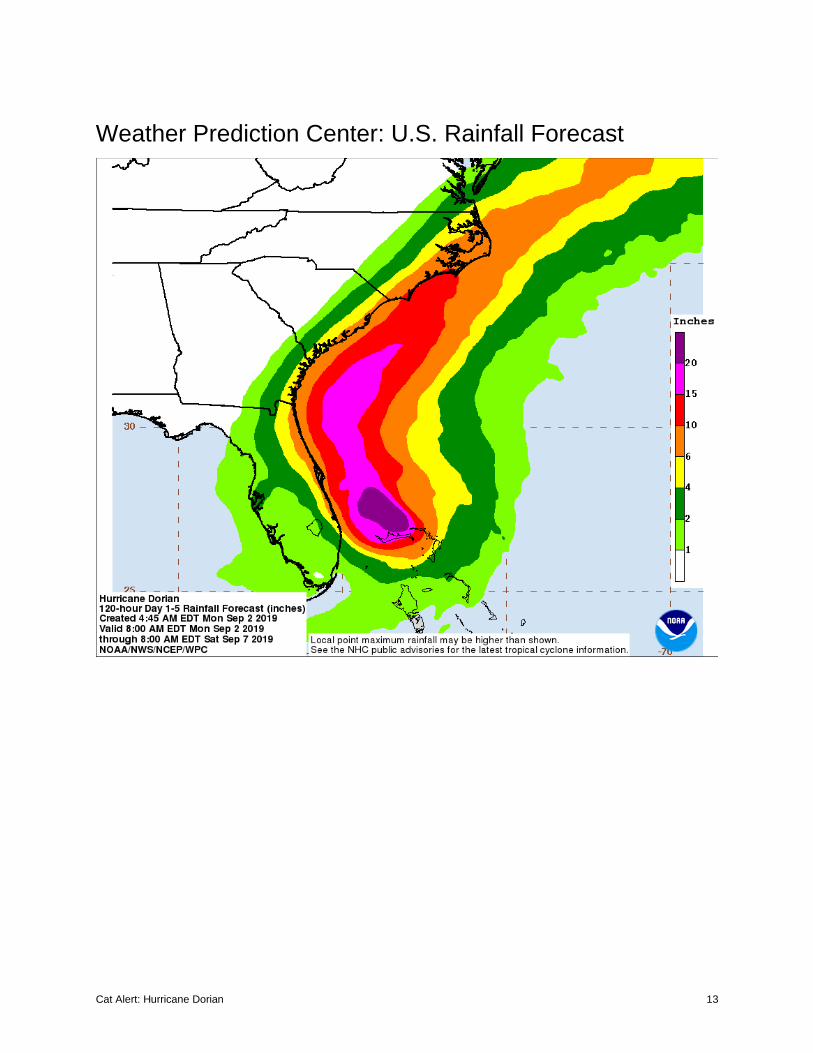
RAINFALL: Dorian is expected to produce the following rainfall totals through late this week:
Northwestern Bahamas: Additional 6 to 12 inches, isolated storm totals of 30 inches
Central Bahamas: Additional 1 to 3 inches, isolated storm totals of 6 inches
Coastal Carolinas: 5 to 10 inches, isolated 15 inches
Atlantic Coast from the Florida peninsula through Georgia: 4 to 8 inches, isolated 10 inches
This rainfall may cause life-threatening flash floods.
SURF: Large swells are affecting east-facing shores of the Bahamas and the Florida east coast and will
spread northward along the southeastern United States coast during the next few days. These swells are
likely to cause life-threatening surf and rip current conditions.
TORNADOES: Isolated tornadoes are possible through Tuesday along the eastern coast of Florida.
Cat Alert: Hurricane Dorian 5
National Hurricane Center (NHC) Forecast
Cat Alert: Hurricane Dorian 6
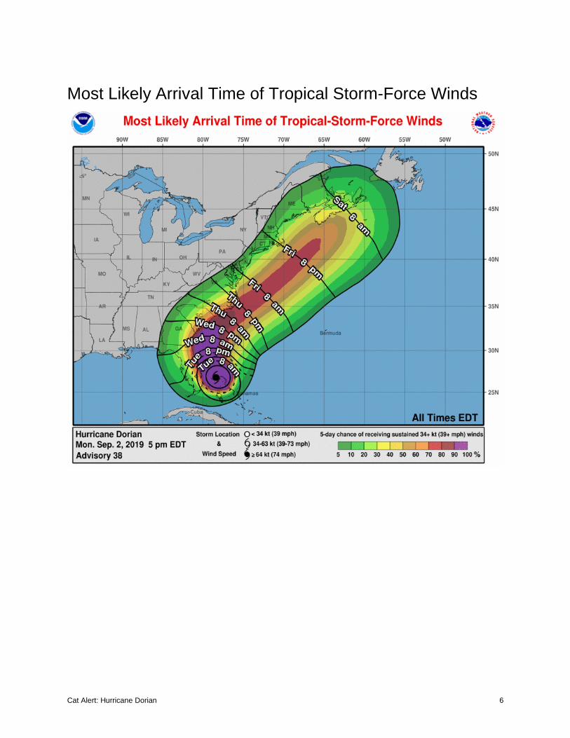
Most Likely Arrival Time of Tropical Storm-Force Winds
Cat Alert: Hurricane Dorian 7
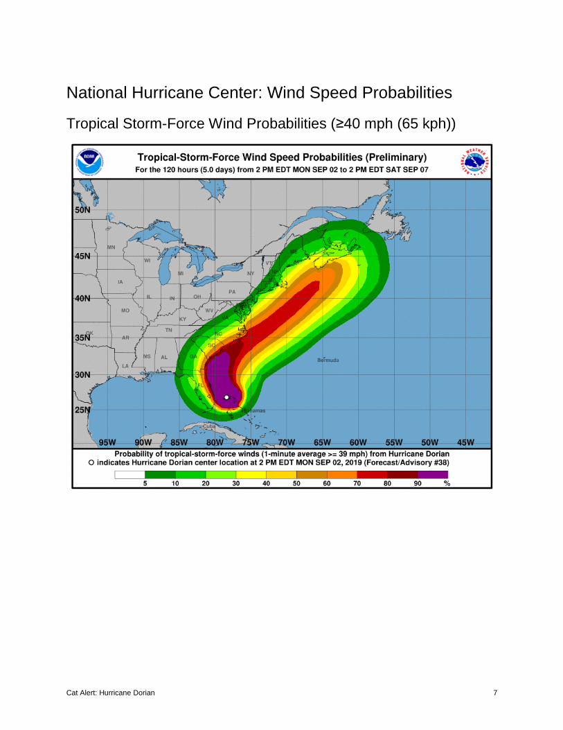
National Hurricane Center: Wind Speed Probabilities
Tropical Storm-Force Wind Probabilities (≥40 mph (65 kph))
Cat Alert: Hurricane Dorian 8
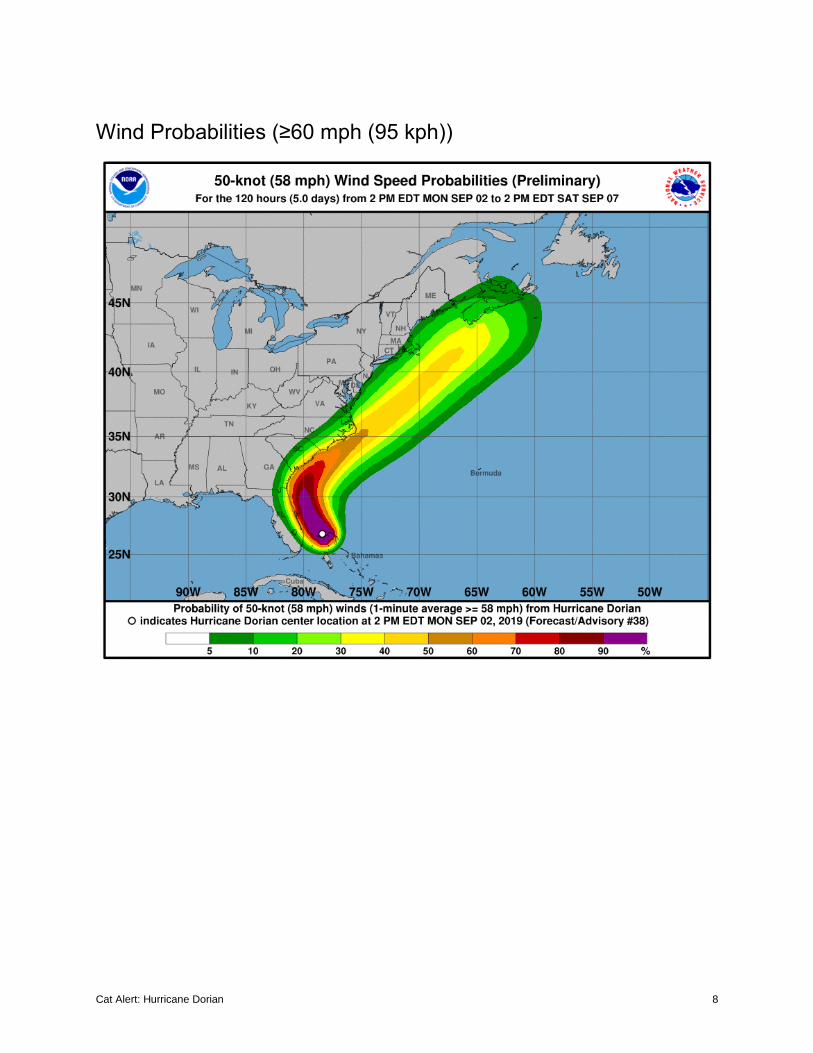
Wind Probabilities (≥60 mph (95 kph))
Cat Alert: Hurricane Dorian 9
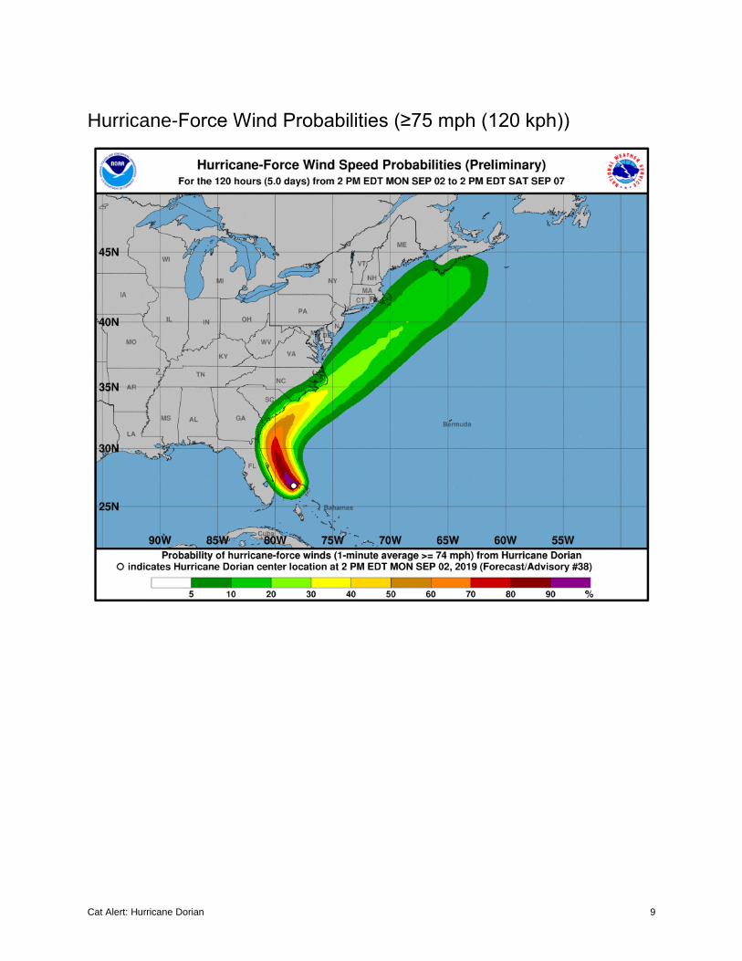
Hurricane-Force Wind Probabilities (≥75 mph (120 kph))
Cat Alert: Hurricane Dorian 10
United States: Storm Surge Watches & Warnings
Cat Alert: Hurricane Dorian 11
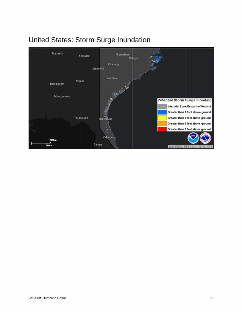
United States: Storm Surge Inundation
Cat Alert: Hurricane Dorian 12
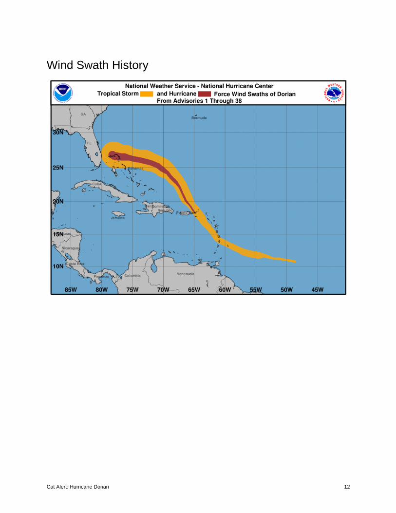
Wind Swath History
Cat Alert: Hurricane Dorian 13
Weather Prediction Center: U.S. Rainfall Forecast
Cat Alert: Hurricane Dorian 14
United States: Flash Flood Potential
Cat Alert: Hurricane Dorian 15
Current ‘Spaghetti’ Model Output Data
Source: NHC
Additional Information and Update Schedule
Wind intensity forecasts and forecast track information can be found via the National Hurricane Center at
www.nhc.noaa.gov
NEXT CAT ALERT: Tuesday morning after 10:00 AM Central Time (15:00 UTC).
Cat Alert: Hurricane Dorian 16
*Tropical Cyclone Intensity Classifications for Global Basins
WIND SPEED BASINS AND MONITORING BUREAU
KTS1 MPH1 KPH1
NE Pacific, Atlantic
NW Pacific
NW Pacific
SW Pacific
Australia
SW Indian
North Indian
National Hurricane
Center (NHC)
Joint Typhoon Warning Center (JTWC)
Japan Meteorological Agency (JMA)
Fiji Meteorologica
l Service (FMS)
Bureau Of Meteorology
(BOM)
Meteo-France (MF)
India Meteorological Department
(IMD)
30 35 55 Tropical
Depression
Tropical Depressio
n
Tropical Depression
Tropical Depression
Tropical Low
Tropical Depressio
n
Deep Depression
35 40 65
Tropical Storm
Tropical Storm
Tropical Storm
Cat. 1 Tropical Cyclone
Cat. 1 Tropical Cyclone
Moderate Tropical Storm
Cyclonic Storm
40 45 75
45 50 85
50 60 95
Severe Tropical Storm
Cat. 2 Tropical Cyclone
Cat. 2 Tropical Cyclone
Severe Tropical Storm
Severe Cyclonic Storm
55 65 100
60 70 110
65 75 120
Cat. 1 Hurricane
Typhoon
Typhoon
Cat. 3 Severe Tropical Cyclone
Cat. 3 Severe Tropical Cyclone
Tropical Cyclone
Very Severe
Cyclonic Storm
70 80 130
75 85 140
80 90 150
85 100 160
Cat. 2 Hurricane
90 105 170
Cat. 4 Severe Tropical Cyclone
Cat. 4 Severe Tropical Cyclone
Intense Tropical Cyclone
95 110 175
100 115 185
Cat. 3 Major
Hurricane
105 120 195
110 125 205
Cat. 5 Severe Tropical Cyclone
Cat. 5 Severe Tropical Cyclone
115 130 210
120 140 220
Cat. 4 Major
Hurricane Very
Intense Tropical Cyclone
Super Cyclonic Storm
125 145 230
130 150 240
Super Typhoon
135 155 250
140 160 260 Cat. 5 Major
Hurricane >140 >160 >260
Cat Alert: Hurricane Dorian 17
About Aon
Aon plc (NYSE:AON) is a leading global professional services firm providing a broad range of risk,
retirement and health solutions. Our 50,000 colleagues in 120 countries empower results for clients by
using proprietary data and analytics to deliver insights that reduce volatility and improve performance.
© Aon plc 2019. All rights reserved.
The information contained herein and the statements expressed are of a general nature and are not intended to address the
circumstances of any particular individual or entity. Although we endeavor to provide accurate and timely information and use
sources we consider reliable, there can be no guarantee that such information is accurate as of the date it is received or that it will
continue to be accurate in the future. No one should act on such information without appropriate professional advice after a
thorough examination of the particular situation.
Copyright © by Impact Forecasting®
No claim to original government works. The text and graphics of this publication are provided for informational purposes only.
While Impact Forecasting® has tried to provide accurate and timely information, inadvertent technical inaccuracies and typographical
errors may exist, and Impact Forecasting® does not warrant that the information is accurate, complete or current. The data
presented at this site is intended to convey only general information on current natural perils and must not be used to make
life-or-death decisions or decisions relating to the protection of property, as the data may not be accurate. Please listen to official
information sources for current storm information. This data has no official status and should not be used for emergency response
decision-making under any circumstances.
Cat Alerts use publicly available data from the internet and other sources. Impact Forecasting® summarizes this publicly available
information for the convenience of those individuals who have contacted Impact Forecasting® and expressed an interest in natural
catastrophes of various types. To find out more about Impact Forecasting or to sign up for the Cat Reports, visit Impact
Forecasting’s webpage at impactforecasting.com.
Copyright © by Aon plc. All rights reserved. No part of this document may be reproduced, stored in a retrieval system, or transmitted
in any form or by any means, electronic, mechanical, photocopying, recording or otherwise. Impact Forecasting® is a wholly owned
subsidiary of Aon plc.