Embed Size (px)
Citation preview
Kansas and Missouri Severe Weather Awareness Week set for:March 4-8, 2013
Kansas and Missouri Tornado Drill scheduled for:Tuesday, March 5 at 1:30 p.m.
The National Weather Service in Pleasant Hill, in conjunction with the Kansas Division of Emergency Management, the Missouri State Emergency Management Agency, and local emergency management agencies, will conduct the annual statewide Severe Weather Awareness Week for both Kansas and Missouri March 4th through March 8th, 2013**.
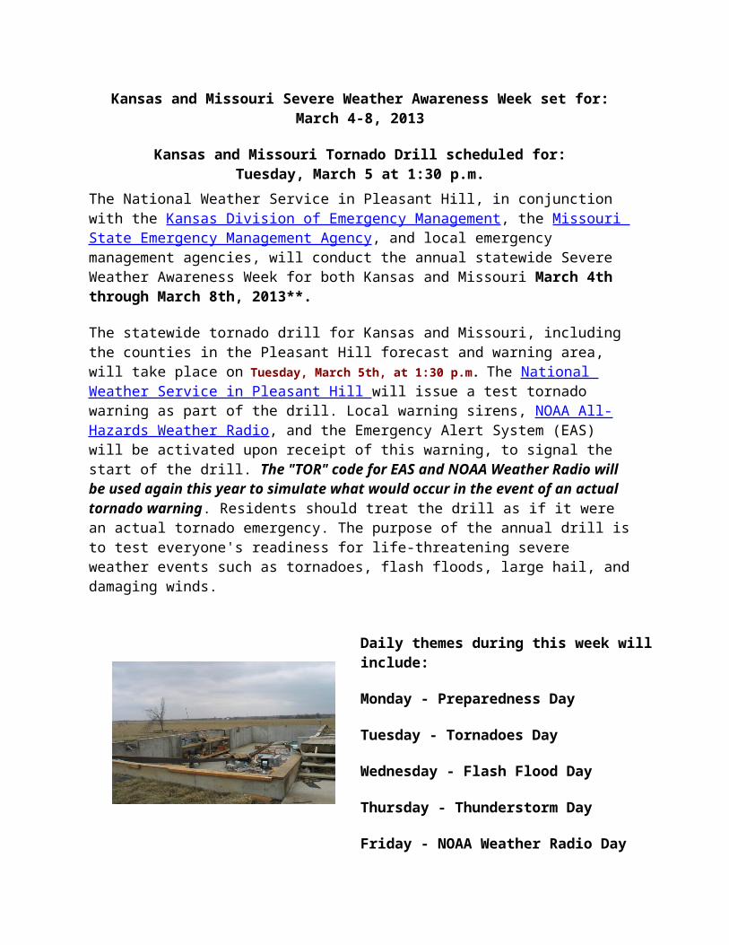
The statewide tornado drill for Kansas and Missouri, including the counties in the Pleasant Hill forecast and warning area, will take place on Tuesday, March 5th, at 1:30 p.m. The National Weather Service in Pleasant Hill will issue a test tornado warning as part of the drill. Local warning sirens, NOAA All-Hazards Weather Radio, and the Emergency Alert System (EAS) will be activated upon receipt of this warning, to signal the start of the drill. The "TOR" code for EAS and NOAA Weather Radio will be used again this year to simulate what would occur in the event of an actual tornado warning. Residents should treat the drill as if it were an actual tornado emergency. The purpose of the annual drill is to test everyone's readiness for life-threatening severe weather events such as tornadoes, flash floods, large hail, and damaging winds.
Daily themes during this week will include:
Monday - Preparedness Day
Tuesday - Tornadoes Day
Wednesday - Flash Flood Day
Thursday - Thunderstorm Day
Friday - NOAA Weather Radio Day
The 2013 severe weather season has already become quite active across the country, so it is imperative you prepare now. You are encouraged to use this week, and the annual test day, to review your severe weather safety plans. Practice what you would do in a real severe weather emergency.
Links at the bottom of this page offer several severe weather awareness resources for the media, emergency managers and the public to use. Feel free to download and duplicate as needed for your local awareness campaigns.
Throughout the spring and summer, be sure to check out our Severe Weather Tracker web page, and our Forecast web page, to keep track of the latest forecasts, advisories, watches, and warnings.
You can also receive weather updates and communicate with us via social media. Please make sure to "like" us on Facebook and "follow" our Twitter feed.
http://www.crh.noaa.gov/eax/?n=severewx-awareness

National Weather Service Severe Weather Products and What They Mean
The National Weather Service (NWS) uses specific terminology to relay the weather threat to the public in the fastest way possible. In the spring and summer, there are a variety of watches, warnings, and statements you need to understand in order to be prepared. Keep these in mind as we approach the 2010 Severe Weather Season:
TORNADO WATCH - Means that conditions are favorable for tornadoes to develop. It is normally issued for 4 to 6 hours, and can include many counties. If you are in or near the Tornado Watch area, stay informed with NOAA Weather Radio, commercial radio, or television.
TORNADO WARNING - Means that a tornado has been sighted, or a developing tornado is reported by trained spotters or indicated on Doppler radar. A warning is typically issued for a small area for less than 45 minutes. If a Tornado Warning is issued for your area, take cover immediately!
SEVERE THUNDERSTORM WATCH - Means that conditions are favorable for thunderstorms to produce large hail or damaging winds. These watches are normally issued for 4 to 6 hours at a time, and for a large number of counties. Once again, if you are in or near the Severe Thunderstorm Watch area, stay informed with NOAA All-Hazards Weather Radio, commercial radio, or television.
SEVERE THUNDERSTORM WARNING - Means that a severe thunderstorm has been detected by Doppler radar, or by a trained spotter. The NWS in Pleasant Hill will issue a Severe Thunderstorm Warning for storms capable of producing wind gusts 58 mph or stronger, or hail 1 inch in diameter or larger. Take cover quickly if a severe thunderstorm approaches you, or if one is reported in your area.
SEVERE WEATHER STATEMENT - The Severe Weather Statement is a follow-up to Tornado and Severe Thunderstorm Warnings. These statements inform you of the current status of a tornado or severe thunderstorm. In addition, it gives the history of a storm, where it is moving, and who it will affect. This NWS product is also used to cancel or expire all or part of a warning.
SIGNIFICANT WEATHER ADVISORY - A Special Weather Statement called a “Significant Weather Alert” will be issued to either address storms that are either just below severe criteria, for storms that are expected to produce penny or nickel size hail, or to give a heads-up for storms that *are* severe and are moving towards your area. The Significant Weather Alert contains important information for storms just below warning criteria!
FLOOD WATCH - This is issued when heavy rain may develop and result in flooding or flash flooding in or near the watch area. A Flood Watch will also be issued if ground,

river/stream conditions, or radar surveillance indicate flash flooding is possible, but not imminent within a designated area.
FLASH FLOOD WARNING - Means flash flooding has developed or is imminent in the area. A Flash Flood warning is typically issued for a period of 6 to 12 hours. When a Flash Flood Warning is issued, move to higher ground immediately!
FLOOD WARNING - A Flood Warning is issued whenever flooding is expected along a gauged river or stream. The warning will be issued for that point specific to the gauge site. Flood Warnings are also issued for counties (or parts of counties) whenever prolonged or slow-response flooding is expected to occur. A Flood Warning may be issued upon the expiration of a Flash Flood Warning, and its duration may last up to a day.
HAZARDOUS WEATHER OUTLOOK - This product issued by the NWS discusses the significant weather threats of the day, and also out through the next seven days. It describes potential weather hazards for an area, and is especially reated for trained spotters and Emergency Managers. The Hazardous Weather Outlook will detail the type of severe weather expected (if any), timing, and expected location of the severe weather. This product should be used daily as a briefing tool for severe weather potential.
Kansas and Missouri Severe Weather Awareness WeekMarch 4-8, 2013
http://www.crh.noaa.gov/eax/?n=severewx-products

How to Prepare Your Family for Severe WeatherSevere weather will happen, and eventually it will affect you in some way. So the only thing you can do is to try and be prepared the best you can. In some cases, there are no easy answers to the many questions and problems that can arise. You simply have to prepare for your situation with the resources you have available. The first thing to do is develop a preparedness plan. But before you get into the details of your plan, there are some initial steps you should take.
Step 1: Identify the severe weather hazards you may face.
In the Central United States , severe thunderstorms are a fact of life. These storms can produce tornadoes, damaging wind gusts, large hail, and heavy rain that can produce flash flooding. At some point in your life, you will likely be faced with one of these hazards.
Step 2: Set up your plan.
Everyone should have a severe weather plan for their home. Likewise, businesses need to have a plan for the workplace. There will be similarities, but there will also be differences between the two. Following are some ideas that can be applied to both.
1. Establish who is responsible for the plan. Someone needs to be in charge. For a large workplace that runs several shifts, you may have several people responsible for the plan.
2. How will you receive weather warnings? NOAA Weather Radio is a great way to receive severe weather warnings from the National Weather Service. You can also get information from the commercial media, such as radio and television. The Internet is also a great way to get information. However, do not depend solely on one method. Have multiple ways to receive critical weather information.
3. If you receive a weather warning such that you need to activate your plan, how will you inform the people you are responsible for? In a home that should not be a problem, but in a large workplace you have to have a method for communicating the severe weather information to everyone present.
4. Establish shelters area in your home or workplace. Depending on the amount of people who need to be sheltered, multiple areas may be needed. If your home or building is in an area prone to flooding, you need to have an evacuation plan in place.

Step 3: Practice your plan!
Conduct drills and then review the drill to find strengths and weaknesses and make improvements where necessary. It is hard to foresee every circumstance, but drills can often bring out problems that were not previously seen.
Some things you can do to protect your family include:
• Have a family disaster plan. A plan will cover what to do, where to meet, and how to contact family members in the event of a fire or severe weather. Make sure all family members know about the family emergency plan. Give emergency information to babysitters and other caregivers.
• Put together an emergency supply kit for your home, for your office, your car, and one for your child at school. A kit should have bottled water, a radio with extra batteries, a flashlight, prescription medicine and first aid supplies.
• Purchase a generator for your home or business. A generator will provide heat during a power outage in cold weather. It will also keep your food from spoiling, and lights on. A generator can keep life safety health equipment functioning (ventilators, oxygen, monitors, or keep insulin cool) during a power outage. Remenber though to always follow the instructions when using a generator. For example, never use a generator in a closed structure. The engine gives off deadly carbon monoxide gas . Always place the generator outside.
• Make sure all family members know all possible ways to exit your home and where to meet outside the house. Keep all exits clear.
• Conduct a tornado, fire and earthquake drill once every six months.
• Choose a place for your family to meet after a disaster in case you are at work or school when the disaster happens.
• Know how to contact your children at their school or daycare and where you can pick them up after a disaster. Designate a specific person to pick up your child if you cannot. Make sure the school or daycare has the most current emergency release information.
• Have a tone-alert weather radio to receive severe weather warnings. Also have a portable radio with extra batteries incase there are power outages. This allows you to get the most current weather and emergency information quickly.
• Learn first aid and CPR.

• In the event of a flood, tornado or earthquake, learn how to shut off your water,
gas and electricity. Know where to find the shut-off valves and switches.
• Keep a small amount of cash on hand. If the power is out, AMT machines
Kansas and Missouri Severe Weather Awareness WeekMarch4-8, 2013
http://www.crh.noaa.gov/eax/?n=severewx-prws

Safe RoomsTornado and High Wind Protection
During a tornado or severe thunderstorm, the most important consideration is to get those at risk into a sturdy shelter immediately. To survive a severe windstorm, those in the path must have three things. First, adequate advanced warning to confirm the threat to themselves; second, a severe weather emergency plan for the home; and third, a sturdy shelter for surviving extreme wind speeds.
A severe thunderstorm with 60 mph winds may not cause significant structural damage to a home, but few buildings are designed to withstand extreme straight-line wind speeds or a strong violent tornado. When wind speeds exceed about 100 mph, the potential for damage to a home increases substantially, even when that home is built to existing codes.
A "safe room" is a reinforced area of a home designed to withstand severe windstorms. The safe room concept was developed by the Federal Emergency Management Agency (FEMA) and the Wind Engineering Research Center at Texas Tech University, and was based on the need to develop affordable yet sturdy shelters within single family homes. While basements offer some protection from damaging winds, the level of protection can be increased greatly by building a reinforced shelter area in a basement, or constructing a shelter in an above-ground room such as an interior closet, or a small study room.
An effective safe room must be strong enough to survive extreme wind speeds and the impact of airborne debris, sufficiently affordable to appeal to homeowners, and accessible quickly in the event a severe storm approaches. Safe rooms are easiest to install when the home is being built, however, safe room shelters can also be added to many existing homes. A variety of shelter options exist for homes with basements, homes built on a "slab-on-grade" foundation, and for homes with a "crawlspace" foundation. Typical costs range from $2000 for a simple "lean-to" shelter in a new home basement, to $6000 or more for an above-ground steel sheathing shelter.
Once the shelter is constructed, an emergency supply kit should be placed in the shelter. The kit should include an adequate supply of food and water for everyone that will be in the shelter, a NOAA Weather Radio and an AM/FM radio, first aid kit, flashlight, cell phone or radio, clothing for long-term sheltering, and formula, diapers, and bottles for babies.
After a disaster, an often-quoted saying is that, "Possessions can be replaced, but people cannot." The addition of a safe room in a new or existing home is one of the best investments of time and dollars to ensure you survive nature's most violent storms.
Detailed construction plans and information related to safe rooms can be found from FEMA at the following website: http://www.fema.gov/hazard/tornado/to_saferoom.shtm.

Kansas and Missouri Severe Weather Awareness WeekMarch 4-8, 2013
http://www.crh.noaa.gov/eax/?n=severewx-saferoom
Tornado Safety
IN HOMES OR SMALL BUILDINGS: Go to the basement (if available) or to an interior room on the lowest floor, such as a closet or bathroom. Upper floors are unsafe. If there is no time to descend, go to a closet, a small room with strong walls, or an inside hallway. Wrap yourself in overcoats or blankets to protect yourself from flying debris.
IN SCHOOLS, HOSPITALS, FACTORIES, OR SHOPPING CENTERS: Go to interior rooms and halls on the lowest floor. Stay away from glass enclosed places or areas with wide-span roofs such as auditoriums and warehouses. Crouch down and cover your head. Don't take shelter in halls that open to the south or the west. Centrally-located stairwells are good shelter.
IN HIGH-RISE BUILDINGS: Go to interior small rooms or halls. Stay away from exterior walls or glassy areas.
IN MOBILE HOMES: ABANDON THEM IMMEDIATELY! Most deaths occur in cars and mobile homes. If you are in either of those locations, leave them and go to a substantial structure or designated tornado shelter.
IN VEHICLES: IF POSSIBLE, DRIVE AWAY! If not, get into a sturdy shelter (building). As a last resort, you need to make a personal decision whether to ride it out in your car hunched down below the windows with your SEATBELT ON, or to lie flat in the nearest ditch or depression with your hands covering your head.
IF NO SUITABLE STRUCTURE IS NEARBY: Lie flat in the nearest ditch or depression and use your hands to cover your head, or remain in your vehicle with your seat belt fastened, crouching down below the window. These options should be considered last resorts.
DURING A TORNADO: Absolutely avoid buildings with large free-span roofs. Stay away from west and south walls. Remember, seek shelter on the lowest level, go to the smallest room, and center part of the building.
No matter where you are, do some advance planning if possible. Identify protective areas you can get to in a hurry. Obtain a NOAA Weather Radio that will provide an alarm if a tornado watch or warning is in effect for your county. The key to tornado survival is to be prepared and to take immediate action when a warning is issued or when you spot a tornado. Remember, the actions you take during a tornado may save your life and the lives of your family.
You can also find additional safety information in the NOAA brochure "Tornadoes, Thunderstorms and Lightning", available on-line from the National Weather Service.

Kansas and Missouri Severe Weather Awareness WeekMarch 4-8, 2013
http://www.crh.noaa.gov/eax/?n=severewx-torsafety
The Tornado FAQ, by Roger Edwards, Storm Prediction Center:
http://www.spc.noaa.gov/faq/tornado/
The Enhanced Fujita Scale (EF Scale):
http://www.spc.noaa.gov/efscale/
Tornado Environment Browser:
(This is really cool, you need to check this out. With this you can click on your location and it will show you all the tornadoes in your area from 1962-2011 along with Fujita Scale strength of the tornadoes and also the tornadoes path along with other statistical data. Wow !)
http://www.spc.noaa.gov/exper/envbrowser/

Turn Around, Don't Drown!!Flash Flooding and Flood Safety
Tornadoes, flooding also deserves plenty of attention. In the past ten years, flooding has accounted for 14 deaths and $41 million in damage in Kansas. In Missouri, flooding has resulted in 46 deaths and $147 million in property damage since 1995. These numbers compare very close to the number of tornadoes deaths (15 and 31) and tornado damage ($208 million and $136 million) across both states respectively during the same time period.
When these warnings are issued for your area, or the moment you realize that a flash flood is imminent, act quickly to save yourself. YOU MAY ONLY HAVE SECONDS WHEN FLOODING THREATENS!
How do flash floods occur?
Several factors contribute to flash flooding. The two key elements are rainfall intensity and duration. Intensity is the rate of rainfall, and duration is how long the rain lasts. Topography, soil conditions, and ground cover also play an important role. Most flash floods are caused by slow-moving thunderstorms or thunderstorms repeatedly moving over the same area.
When a Flood or Flash Flood WATCH is issued, be alert to signs of flash flooding and be ready to evacuate on a moment's notice.
When a Flash Flood WARNING is issued for your area, or the moment you realize that a flash flood is imminent, act quickly to save yourself.
Get out of areas subject to flooding. This includes dips, low spots, and low water crossings.
Do not attempt to walk across flow streams. Water moving swiftly, even just 6 inches deep, can sweep you off your feet.
Be cautious at night when flooding is hard to recognize. Also, be aware that storms that are miles away may bring raging water your way.
Be aware that the road bed may not be intact under the water.
Do not underestimate flood waters. Remember: Turn Around, Don't Drown! Go another way. NEVER drive through flooded roads or low water crossings.
Kansas and Missouri Severe Weather Awareness Week
March 12-16, 2012

http://www.crh.noaa.gov/eax/?n=floodsafety
Lightning Kills: Play it Safe!
Lightning is one of nature's most awe inspiring and dangerous phenomenon. The average lightning flash could light a 100-watt light bulb for more than three months! The temperature of a lightning bolt may reach 50,000 degrees Fahrenheit which is hotter than the surface of the sun!
On average, lightning kills one person in Kansas and Missouri each year, and about 73 nationwide. Lightning remains one of the most deadly weather phenomena in the United States, and it can occur almost anywhere throughout the entire year.
Many people are injured or killed due to misinformation and inappropriate behavior during thunderstorms. A few simple precautions can reduce many of the dangers posed by lightning. Remember, Lightning Kills, Play it Safe!
AVOID being in or near:
High places and open fields, isolated trees, unprotected gazebos, rain or picnic shelters, baseball dugouts, communication towers, flagpoles, light poles, bleachers (metal or wood), metal fences, convertibles, golf carts, water (ocean, lakes, swimming pools, rivers, etc.).
When inside a building AVOID:
Use of the telephone or computer, taking a shower, washing your hands, doing dishes, or any contact with conductive surfaces with exposure to the outside such as metal door or window frames, electrical wiring, telephone wiring, cable TV wiring, plumbing, etc.
If driving:
Stay in your car! An enclosed automobile offers reasonably good protection from lightning, as long as you don't touch metal.
Lightning is a year-round threat. The National Weather Service will conducts its annual Lightning Safety Awareness Week from June 23-29, 2013. To learn more about lightning safety, and for additional resources for promoting lightning safety in your community, check out www.lightningsafety.noaa.gov.
Kansas and Missouri Severe Weather Awareness WeekMarch 3-9, 2013

http://www.crh.noaa.gov/eax/?n=severewx-lightning
Hail and Damaging Winds
Hailstone which fell near Meadville, MO May 24, 2004. This hailstone set a Missouri state
record!
Hail remains one of the most costly severe weather phenomena observed in the United States every
year. Damage from hail not only occurs to crops, but also to homes, vehicles and businesses.
Hailstorms such as the one depicted to the right produce around $2 billion worth of property damage each year. Damaging hail the size of golf balls or larger occur with the strongest of all thunderstorms, and hail will usually accompany tornadic thunderstorms. Remain alert for severe thunderstorm warnings from the National Weather Service, and use this valuable information to protect your property from the threat of hail.
If caught outdoors during a hailstorm, seek shelter in a reinforced building as quickly as possible. The key to personal safety in a hailstorm is to protect yourself from the falling hailstones. Hail rarely kills people, but it can become a killer if precautions are not taken. In China in May of 1986, intense hail killed 100 people, injured 9000, and destroyed 35,000 homes.
Damaging winds come in many forms, sometimes from squall lines of thunderstorms and other times in the form of downburst winds. The most frequently encountered type of damaging straight-line wind in a thunderstorm is that associated with the leading edge of the rain-cooled outflow, known as the gust front. Although most thunderstorm outflow winds range from 30 to 50 mph, on occasion these winds can exceed 60 mph. These outflow winds typically last 5 to 15 minutes. Sometimes, the strongest winds are not associated with the gust front, but rather occur behind the gust front in close proximity to the area of heaviest rain.
When these winds are potentially damaging to structures on the ground, or to aircraft in flight, these winds are referred to as downbursts. Dr. Theodore Fujita of the University of Chicago, is credited with discovering downbursts in the mid 1970s, following investigation of the crash of Eastern Airlines Flight 66 in New York. There are two types of downbursts: microbursts produce strong winds less than 2.5 miles in diameter, while macrobursts result in strong winds over an area 2.5 miles in diameter or larger. Downbursts occur with all types of thunderstorms, from single cells to supercells. In fact, the most damaging downbursts often are produced by weaker, benign-looking storms. Downburst-producing storms often give little advance indications of the imminent

danger on weather radar or to the spotter, so warnings are difficult to issue. Once the strong winds reach the ground, Doppler Radar can frequently detect the stronger winds, but the threat of additional damaging winds may be over.
While downbursts are typically produced within a single thunderstorm cell, occasionally many storms will organize into a squall line and produce damaging winds over a much larger area for a period of an hour or longer. Damaging winds of this type are known as Bow Echoes, since a portion of the squall line accelerates, or "bows" out in an easterly direction. Supercell storms also occasionally develop into Bow Echoes. In extreme cases, straight-line winds in a Bow Echo can approach 150 mph, stronger than about 80% of all tornadoes! Since Bow Echoes produce distinctive radar echoes and last 1 to 3 hours (sometimes longer), National Weather Service meteorologists can often provide considerable advance warning.
All severe thunderstorms have the potential to produce damaging winds and large hail. Count on your local National Weather Service office for the latest information regarding these weather hazards.
Kansas and Missouri Severe Weather Awareness WeekMarch 4-8, 2013
http://www.crh.noaa.gov/eax/?n=severewx-svrsafety

Be a Force of Nature: National Severe Weather Preparedness WeekMarch 3-9, 2013
Know your risk. Take action. Be an example.
Be a Force of Nature this year with National Severe Weather Preparedness Week, March 3-9, 2013.
During this week, NOAA and FEMA are highlighting the importance of planning and practicing how and where to take shelter before severe weather strikes. Being prepared to act quickly can be a matter of life and death.
Being a force of nature goes beyond taking appropriate preparedness action. It’s about inspiring others to do the same. We’re asking people not only to be prepared, but also to encourage their social network to act by texting, tweeting, or posting a Facebook status update.
Be a Force of Nature Toolkit – get involved
You, too, can Be a Force of Nature in your community. Tweet, write a blog post, develop a presentation – we have everything you need to get started. Be a local hero and spread the word about preparing for severe weather.
Talking PointsGet the facts about how severe weather impacts everyone – and how to prepare for it.
Blog PostDownload and customize for use on your blog.
Press ReleaseIssue a press release on the themes of National Severe Weather Preparedness Week.

Op-EdSubmit an opinion piece to your local newspaper.
Social Media Tools Learn how to share your severe weather preparation plans through Twitter and Facebook.
PresentationMake a presentation to a local group on National Severe Weather Preparedness Week.
Public Service AnnouncementBe a Force of Nature with this public service announcement.
PosterDownload and share the 2013 National Severe Weather Preparedness Week poster.
Be a Force of Nature LogoDownload the Be a Force of Nature graphic for your website.
Severe weather preparedness in your state
Many states have their own severe weather preparedness weeks. Check the Weather Awareness Events Calendar to find yours.
http://www.nws.noaa.gov/com/weatherreadynation/force.html