Embed Size (px)
Citation preview

State of New Hampshire
Current Use
Criteria Booklet For
April 1, 2021 to March 31, 2022
Additional copies of this Current Use Booklet can be obtained:
- Online: http://revenue.nh.gov/current-use/booklets.htm
- On CD, for a fee of $5, by sending a self-addressed stamped disc-envelope and a blank CD to:
NH Department of Revenue Administration c/o Current Use Board PO Box 487 Concord, NH 03302-0487
- For a fee from the NH State Library, Reference and Information Bureau, 20 Park Street, Concord, NH 03301, (603) 271-2144.

2
CURRENT USE CRITERIA BOOKLET
Message from the Current Use Board
Dear Current Use Constituent: Congratulations on enrolling your land or considering enrolling your land into the current use program. Your land enrollment contributes to the preservation of forests, forestry, farming, and open space. Our clean water, clean air, beautiful scenery, and bountiful wildlife are all examples of how beneficial the New Hampshire Current Use Program is for the citizenry and visitors of New Hampshire. New Hampshire’s program is unique compared to other states’ programs because once land is enrolled that land remains in the program until a disqualifying action causes the land to be removed. As members of the Board, we value this program as professionals and landowners (some in the program and some not). More than 50% of the land in New Hampshire is enrolled in current use: a testament to the popularity of this 40+ year old program. A program born out of the idea that open space should be preserved; that forestry operations should not influence the tax rate since the land will continue to have the potential to grow more forestry products; that farmland is beneficial to the state’s economy and should be taxed based on its potential to grow agricultural products; and land which remains unchanged is a true benefit to the citizens of the state and should be incentivized as such. This Current Use Booklet contains applicable laws (RSA’s), administrative rules (referred to as Cub’s), and a handbook section that provides taxpayers and municipal assessing officials the process to enroll and assess the land in current use. Questions that pertain to the current use program may be directed to any of the Current Use Board members, by mail to the Current Use Board, PO Box 487, Concord, NH 03302-0487, in person at 109 Pleasant Street, Concord, NH, by email at [email protected] or by calling (603) 230-5950. Sincerely, The Current Use Board

3
CURRENT USE CRITERIA BOOKLET
Table of Contents
Message from the Current Use Board .................................................................................... 2
Table of Contents .................................................................................................................. 3
Topical Index ......................................................................................................................... 6
Current Use Advisory Board ................................................................................................. 10
History ................................................................................................................................................................. 10
Make-Up ............................................................................................................................................................. 10
Responsibilities ................................................................................................................................................... 10
Current Use Board Members .............................................................................................................................. 11
Current Use Assessment Ranges .......................................................................................... 12
Current Use Law .................................................................................................................. 13
RSA 79-A Current Use Taxation ..................................................................................................... 13
RSA 79-A:1 Declaration of Public Interest ......................................................................................................... 13
RSA 79-A:2 Definitions ....................................................................................................................................... 13
RSA 79-A:3 Current Use Advisory Board; Members, Appointments, Term, Chairman .................................... 14
RSA 79-A:4 Powers and Duties of Board; Rulemaking ...................................................................................... 15
RSA 79-A:5 Assessment of Open Space Land .................................................................................................... 15
RSA 79-A:6 Valuation for Bonding Limit Purposes ............................................................................................ 16
RSA 79-A:6-a Valuation for Computing Equalized Value .................................................................................. 16
RSA 79-A:7 Land Use Change Tax ...................................................................................................................... 16
RSA 79-A:8 Failure to Reapply ........................................................................................................................... 19
RSA 79-A:9 Appeal to Board of Tax and Land Appeals...................................................................................... 19
RSA 79-A:10 Abatement of Land Use Change Tax ............................................................................................. 20
RSA 79-A:11 Appeal to Superior Court .............................................................................................................. 20
RSA 79-A:12 Reclassification by Board of Tax and Land Appeals ..................................................................... 21
RSA 79-A:13 Procedure for Complying With Orders of Board of Tax and Land Appeals ................................. 21
RSA 79-A:14 Neglect of Duty .............................................................................................................................. 21
RSA 79-A:15 to 79-A:21 Repealed ...................................................................................................................... 21
RSA 79-A:22 Lien for Unpaid Taxes .................................................................................................................... 21
RSA 79-A:23 Enforcement .................................................................................................................................. 21
RSA 79-A:24 False Statement ............................................................................................................................. 22
RSA 79-A:25 Disposition of Revenues................................................................................................................ 22
RSA 79-A:25-a Land Use Change Tax Fund ........................................................................................................ 22
RSA 79-A:25-b Procedure for Adoption ............................................................................................................. 22

4
CURRENT USE CRITERIA BOOKLET
RSA 79-A:26 Location of Contiguous Land in More Than One Taxing District ................................................. 23
Landowner Liability ...................................................................................................................... 24
RSA 212:34 Duty of Care .................................................................................................................................... 24
Current Use Administrative Rules ......................................................................................... 26
PART Cub 301 DEFINITIONS ............................................................................................................................... 26
PART Cub 302 CURRENT USE APPLICATION APPROVAL, DENIAL, OR APPEAL ................................................. 30
PART Cub 303 FACTORS AFFECTING CLASSIFICATION AND ASSESSMENT OF CURRENT USE LAND ................ 33
PART Cub 304 CURRENT USE ASSESSMENT OF OPEN SPACE LAND .................................................................. 35
PART Cub 305 ASSESSMENT RANGES FOR CURRENT USE LAND....................................................................... 43
PART Cub 306 CHANGE IN CURRENT USE CLASSIFICATION CATEGORY............................................................ 44
PART Cub 307 CHANGE IN USE OF THE LAND TO A NON-QUALIFYING USE ..................................................... 46
PART Cub 308 ASSESSING THE USE CHANGE TAX ............................................................................................. 47
PART Cub 309 CURRENT USE LAND ASSESSMENT FORMS ................................................................................ 50
PART Cub 310 APPEALS ...................................................................................................................................... 61
APPENDIX............................................................................................................................ 62
Current Use Forms ............................................................................................................... 63
Current Use Assessment Matrix (“Marlow Matrix”) ....................................................................... 63
A-10 Application for Current Use .................................................................................................. 64
CU-12 Summary of Forest Stewardship Plan .................................................................................. 67
A-5 Land Use Change Tax .............................................................................................................. 68
A-5W Warrant for Land Use Change Tax........................................................................................ 71
CU-18 Notice of Change in Current Use Assessment ...................................................................... 72
Current Use Handbook (Pages 73-92) .................................................................................. 73
Application Procedures ................................................................................................................ 73
Landowner Responsibilities ................................................................................................................................ 73
Map Examples ................................................................................................................................................ 75
Assessing Officials’ Responsibilities .................................................................................................................... 85
Tax Collector’s Responsibilities ........................................................................................................................... 85
Contingent Lien ................................................................................................................................................... 86
Land Classifications ...................................................................................................................... 86
Farmland ............................................................................................................................................................. 86
Soil Potential Index (SPI) Definition .................................................................................................................... 86
How to get your Soil Potential Index .................................................................................................................. 86
Agricultural Buildings ...................................................................................................................................... 87

5
CURRENT USE CRITERIA BOOKLET
Assessment Ranges ........................................................................................................................................ 87
Forest Land ......................................................................................................................................................... 87
Classification of Forest Land ........................................................................................................................... 87
How are the Forest Land Rates Determined? ................................................................................................ 87
Assessment within the Range ......................................................................................................................... 88
Clear Cutting ................................................................................................................................................... 88
Unproductive Land .............................................................................................................................................. 88
Assessment ..................................................................................................................................................... 88
Reclassification ............................................................................................................................................... 88
Wetland .............................................................................................................................................................. 89
Other Assessment Issues .............................................................................................................. 89
Buildings in Current Use ...................................................................................................................................... 89
Equalization of Current Use Land ....................................................................................................................... 89
Gravel Pits ........................................................................................................................................................... 89
Posting of Current Use Land ............................................................................................................................... 90
20% Recreational Adjustment ............................................................................................................................ 90
Zoning Requirements .......................................................................................................................................... 90
The Land Use Change Tax ............................................................................................................. 91
Rate ..................................................................................................................................................................... 91
Assessment ......................................................................................................................................................... 91
Amount of Land to be Taxed ............................................................................................................................... 91
Land Use Change Tax Bill .................................................................................................................................... 91
Appeal Procedures .............................................................................................................................................. 92
Supplemental Statutes ........................................................................................................ 93
Soil Potential Index Addendum ..................................................................................................... 98
Production Standard ........................................................................................................................................... 98
Soil Evaluation Factors ........................................................................................................................................ 98
SPI and Prime Farmland ...................................................................................................................................... 99
History of Soil Potential Index ............................................................................................................................. 99
Development of Soil Potential Ratings (SPI) ..................................................................................................... 100
SPI Corrective Measures and Continuing Limitations ....................................................................................... 100
Deriving Corrective Measures and Continuing Limitations for SPI ................................................................... 101

6
CURRENT USE CRITERIA BOOKLET
Topical Index
Topic Statute (RSA) Pages Administrative
Rule Pages
Handbook Pages
Abatement – Land Use Tax 79-A:10 20 Cub 308.04 49 92
Acreage Requirements 79-A:4, I 15 Cub 304.01 35 91
Appeal Procedures
Municipality Cub 304.10 Cub 308.04
43 49
92
NH Board of Tax and Land Appeals 79-A:9 19 Cub 302.05 32 92
Superior Court 79-A:11 20 Cub 302.05 32 92
Application Filing Fee 79-A:5, VII 16 Cub 302.02 30 73
Application for Current Use 79-A:5, II 15 Cub 302 30 85
Assessment of Open Space 79-A:5 15 Cub 304 35
Assessment Ranges
How Assessment Ranges Developed 79-A:4 15 87
Farmland Forestland Forestland w/Documented Stewardship Unproductive Land Wetland
Cub 304.04 Cub 304.05 Cub 304.07 Cub 304.09 Cub 304.09
37 38 40 42 42
86
88
Table of Assessment Ranges 12
Board of Tax and Land Appeals
Abatement of Land Use Change Tax 79-A:10 20 92
Classification Appeal 79-A:9 19
Compliance Procedures 79-A:13 21
Land Use Change Tax Appeal Cub 308.04 49 92
Reclassification 79-A:12 21
Buildings on Open Space Land 79-A:5, I 15
Building Lot Definition Cub 303.02 33 89
Curtilage Definition Cub 301.05 26 89
Change in Use – Another Qualifying Category Change in Use – To Non-Qualifying Category
79-A:7, VII 19
Cub 306 Cub 308
44 46
91
Clear Cutting Cub 304.05 (c) 39 88
Collection of Delinquent Taxes 79-A:23 79-A:7, II
21 17
85
Condominium Development Cub 307.03 47
Conservation Restriction 79-A:7, VI 19
Contiguous Parcels 79-A:26 23 Cub 301.04 26

7
CURRENT USE CRITERIA BOOKLET
Topic Statute Pages Administrative
Rule Pages
Handbook Pages
Current Use Advisory Board
Contact Information 11 69
Members 79-A:3 14 68
Powers and Duties 79-A:4 15 68
Current Use Definitions 79-A:2 13 Cub 301 29
Current Use Forms Cub 309 50 57
Declaration of Public Interest 79-A:1 13
Eminent Domain 79-A:7 VI(a) 19
Equalization of Current Use Assessments 79-A:5 I 15 46
Farm Land Cub 304.03 (d) 38
Forest Land Cub 304.06 (b) 40
Unproductive Land and Wetland Cub 304.09 43
Excavation (Gravel Pits) 79-A:7 IV (b) 18 Cub 303.03 33 89
Farm Land
Assessment 12 Cub 305.02 43 74
Definition 79-A:2 VI 13 Cub 304.03 37
Roads Cub 303.06 34
Soil Potential Index Cub 304.04 37 86
Soil Potential Additional Information 98
Forest Land
Assessment 12 Cub 305.03 44
Assessing Factors: Class, Type, Grade, Location, Site Quality
Cub 304.05 Cub 304.08
38 42
88
Clear Cutting Cub 304.05 (c) 39 88
Definition 79-A:2 VII 13 Cub 304.05 (b) 39
Roads Cub 304.06 34
Forest Land with Documented Stewardship
Assessment 12 Cub 305.04 44
Assessing Factors: Class, Type, Grade, Location, Site Quality
Cub 304.05 Cub 304.08
38 42
Clear Cutting Cub 304.05 (c) 39 88
Definition 79-A:2 VII 13 Cub 304.07 40
Roads Cub 304.06 34
Stewardship Requirements Cub 304.07 40 87

8
CURRENT USE CRITERIA BOOKLET
Topic Statute Pages Administrative
Rule Pages
Handbook Pages
Forms
A-10 Application A-10 Form
79-A:5 III 16 Cub 309.03 50 64
A-5, Land Use Change Tax
79-A:5 II(a) 17 Cub 309.04
47, 69
A-5W, Land Use Change Tax Warrant
79-A:7 II (b) 17 Cub 309.05
57, 71
CU-12, Forest Land with Documented Stewardship
Cub 309.06 57, 67
CU-18 Notice of Change in Current Use Assessment
Cub 309.07 59, 72
Forest Land Assessment Matrix Form (“Marlow Matrix”)
63
Abatement of LUCT to Municipality Cub 308.04 (a) 49
Abatement of LUCT to BTLA Cub 308.04 (c) 49
Gravel Pits – See excavation
Land Use Change Tax 91
Abatement 79-A:10 20
Amount of Land to be Removed 79-A:7 V 18 Cub 307 46 91
Assessment 79-A:7 V(a) 18 Cub 308 47 91
Reasons for Disqualification 79-A:7, IV, V, VI
18, 19 Cub 307.01 46
Exceptions to the Land Use Change Tax 79-A:7 VI 19
Land Use Change Tax Revenues 79-A:25
Land Use Change Tax Fund 79-A:25-a 22
Adoption Procedure 79-A:25-b 22
Liability to Landowners 212:34 24
Liens, Release of 79-A:7 II (c) 17
Maps Cub 301.11 27 75
Municipal Assessing Officials Procedures 85
Notification to Applicant 79-A:5 III 16
Open Space Definition 79-A:2 IX 13
Posting of Land Cub 304.02 36 90
Recreational Reduction 79-A:4 II 15 Cub 304.02 36 90
Registry of Deeds
Recording of Application 79-A:5 VI 16 Cub 309.02 (b) 50
Recording Fee 79-A:5 VII 16 Cub 302.03 31 73
9
CURRENT USE CRITERIA BOOKLET
Topic Statute Pages Administrative Rule
Pages Handbook Pages
Lien Release 79-A:7 II(c) 17 Cub 309.02 (c) 35 92
Right of Way 79-A:7 V(e) 19 Cub 307.01 (e) 46
Roads 79-A:7 IV 18 Cub 303.06 34
Soil Potential Index 86, 98
Assessment 79-A:5 I 15 Cub 304.04 37 74
Definition 79-A:2 XII 14 Cub 301.17 29
Stewardship Requirements Cub 302.01 Cub 304.07
30 40
74
Tax Collector Procedures 79-A:7 16 Cub 308.03 48 85
Unproductive Land
Assessment Cub 305.05 44 88
Assessing Factors: Class, Type, Grade, Location, Site Quality
Cub 304.09 42
Definition 79-A:2 XIII 14 Cub 304.09 (a) 42 88
Timber Harvesting On Cub 306.02 (c) 45
Utility Lines Cub 303.05 34
Valuation for Bond Limit Purposes 79-A:6 16
Valuation for Computing Equalized Value 79-A:6-a 16
Watershed Areas in Other Towns 79-A:26 23
Wetlands 39
Assessment Cub 305.06 44
Assessing Factors: Class, Type, Grade, Location, Site Quality
Cub 304.09 42
Definition 79-A:2 XIV 11 39, 46
Zoning for Determining Building Lot Cub 303.02 (b) 33 90

10
CURRENT USE CRITERIA BOOKLET
Current Use Advisory Board
History
The Current Use Advisory Board was established in 1973 to establish criteria including minimum acreage requirements, current use categories and value ranges; adopt administrative rules and suggest any changes to statute to the legislature.
Make-Up
The Current Use Advisory Board includes 14 members that have a wide range of backgrounds and interests focusing on forest and farmland use (RSA 79-A:3). The members include representatives from the following state agencies: Department of Agriculture, New Hampshire Fish and Game Department, Department of Natural and Cultural Resources and the Department of Revenue Administration. A representative from the University of New Hampshire, College of Life Sciences and a representative from the New Hampshire Association of Conservation Commissions also sit on the Board. There are two members from the legislature, one representative and one senator, and three assessing officials representing cities and towns (all of differing population sizes). There are also three public members, one of whom owns forest and one who owns farmland.
Responsibilities
The Current Use Advisory Board meets regularly to determine the range of values for farmland and forest land for each year, discuss and recommend administrative rule changes, discuss current use issues from the public, and keep abreast of any legal cases and law changes – providing input as needed. The Board holds three public forums in different parts of the state in late fall/winter to provide education about any rule changes and provide an opportunity for assessing officials and landowners to comment on current use changes and rules.
RSA 79-A
RSA 79-A was adopted by the New Hampshire Legislature in 1973. Its stated purpose is to “encourage the preservation of open space, thus providing a healthful and attractive outdoor environment for work and recreation of the State’s citizens…”

11
CURRENT USE CRITERIA BOOKLET
Current Use Board Members
If you have questions about current use, you may contact your local assessing officials, a Current Use Board Member listed below, or the NH Department of Revenue Administration at (603) 230-5096 or by email at [email protected].
Term information received from the Secretary of State’s Office.
This document may be found on the DRA website at:
https://www.revenue.nh.gov/current-use/documents/board-members.pdf

12
CURRENT USE CRITERIA BOOKLET
Current Use Assessment Ranges
April 1, 2021 – March 31, 2022
FARMLAND $25 - $425 per acre ***************************
FORESTLAND Forest Land WITHOUT
Documented Stewardship Forest Land WITH Documented
Stewardship
White Pine $122 - $183 per acre $73 - $110 per acre
Hardwood $57 - $86 per acre $38 - $57 per acre
All Other (Including Naturally Seeded Christmas Trees)
$40 - $60 per acre $24 - $36 per acre
Unproductive Land $24 per acre $24 per acre
Wet Land $24 per acre $24 per acre

13
CURRENT USE CRITERIA BOOKLET
Current Use Law
Note: The statutes provided in this booklet, while believed to be accurate, are provided for informational purposes only. The statutes, taken from the State of New Hampshire website, are based on updates as of July 19, 2018. For the official version of any statute, please consult the bound volumes and supplements of the New Hampshire Revised Statutes Annotated, published by West, a Thomson business. Complete copies of RSA 79-A and RSA 212:34 with source notes can be found on the State of New Hampshire website at www.nh.gov/glance/laws-rules.htm.
RSA 79-A Current Use Taxation
www.gencourt.state.nh.us/rsa/html/v/79-a/79-a-mrg.htm
RSA 79-A:1 Declaration of Public Interest It is hereby declared to be in the public interest to encourage the preservation of open space, thus providing a healthful and attractive outdoor environment for work and recreation of the state's citizens, maintaining the character of the state's landscape, and conserving the land, water, forest, agricultural and wildlife resources. It is further declared to be in the public interest to prevent the loss of open space due to property taxation at values incompatible with open space usage. Open space land imposes few if any costs on local government and is therefore an economic benefit to its citizens. The means for encouraging preservation of open space authorized by this chapter is the assessment of land value for property taxation on the basis of current use. It is the intent of this chapter to encourage but not to require management practices on open space lands under current use assessment.
RSA 79-A:2 Definitions In this chapter: I. "Assessing official" means the assessing authority of any town, city or place. II. "Board" means the current use board established by RSA 79-A:3. III. "Board of tax and land appeals" means the board of tax and land appeals established pursuant to the provisions of RSA 71-B:1. IV. "Commissioner" means the commissioner of the department of revenue administration. V. "Current use value" means the assessed valuation per acre of open space land based upon the income-producing capability of the land in its current use solely for growing forest or agricultural crops, and not its real estate market value. This valuation shall be determined by the assessor in accordance with the range of current use values established by the board and in accordance with the class, type, grade and location of land. VI. "Farm land" means any cleared land devoted to or capable of agricultural or horticultural use as determined and classified by criteria developed by the commissioner of agriculture, markets, and food and adopted by the board. VII. "Forest land" means any land growing trees as determined and classified by criteria developed by the state forester and adopted by the board. For the purposes of this paragraph, the board shall recognize the cost of responsible land stewardship in the determination of assessment ranges. VIII. "Land use change tax" means a tax that shall be levied when the land use changes from open space use to a non-qualifying use. IX. "Open space land" means any or all farm land, forest land, or unproductive land as defined by this
Note: If you hover the cursor over the Headings, an arrow will appear to the left that shrinks and expands the text.

14
CURRENT USE CRITERIA BOOKLET
section. However, "open space land" shall not include any property held by a city, town or district in another city or town for the purpose of a water supply or flood control, for which a payment in place of taxes is made in accordance with RSA 72:11. X. "Owner" means the person who is the owner of record of any land. XI. "Person" means any individual, firm, corporation, partnership or other form of organization or group of individuals. XII. "Soil potential index" means the production capability of land as determined by the United States Natural Resources Conservation Service. XIII. "Unproductive land" means land, including wetlands, which by its nature is incapable of producing agricultural or forest products due to poor soil or site characteristics, or the location of which renders it inaccessible or impractical to harvest agricultural or forest products, as determined and classified by criteria developed by the board. The board shall develop only one category for all unproductive land, setting its current use value not to exceed that of the lowest current use value established by the board for any other category. XIV. "Wetlands" means those areas of farm, forest and unproductive land that are inundated or saturated by surface water or groundwater at a frequency and duration sufficient to support, and that under normal circumstances do support, a prevalence of vegetation typically adapted for life in saturated soil conditions.
RSA 79-A:3 Current Use Advisory Board; Members, Appointments, Term, Chairman I. There is hereby established a current use board which shall be administratively attached to the department of revenue administration, as provided in RSA 21-J:1-a. II. The board shall consist of 14 members to be appointed as follows: (a) Three members who are assessing officials shall be appointed by the governor with the advice and consent of the council, one of whom shall be an assessing official in a town with a population of less than 5,000; one of whom shall be an assessing official in a town with a population of more than 5,000; and one of whom shall be an assessing official in a city. Each member shall hold office for a term of his or her position as assessing official or for 2 years, whichever is shorter, and until a successor shall have been appointed and qualified, and any vacancy shall be filled for the unexpired term, by the governor with the advice and consent of the council. No other members of the board shall be or have been certified under RSA 21-J:14-f, except for the commissioner of the department of revenue administration or the commissioner's designee. (b) One member of the senate appointed by the president of the senate. The term of said member shall be coterminous with his term as senator to which he was elected at the time of his appointment. A vacancy shall be filled for the unexpired term by the president of the senate. (c) One member of the House of Representatives, appointed by the speaker of the house. The term of said member shall be coterminous with his term as representative to which he was elected at the time of his appointment. A vacancy shall be filled for the unexpired term by the speaker of the house. (d) The commissioner of agriculture, markets, and food, or his designate. (e) The commissioner of the department of natural and cultural resources, or his designate. (f) The dean of the college of life sciences and agriculture of the University of New Hampshire, or his designate. (g) The commissioner of revenue administration, or his designee. (h) The executive director of the New Hampshire association of conservation commissions, or designee. (i) The executive director of the department of fish and game, or his designate. (j) Three members of the public appointed by the governor with the advice and consent of the council, at least 2 of whom shall represent the interests of current use landowners. Of these 2, one shall own

15
CURRENT USE CRITERIA BOOKLET
forest land under current use assessment, and one shall own farm land under current use assessment. III. Members of the current use advisory board who are not state employees or legislators shall be paid $25 a day, each, for such time as they are actually engaged in the work of the board, all members shall be paid their actual expenses incurred as a result of such work, and nonlegislative members shall be paid mileage at the same rate as state employees but the legislative members shall be paid mileage at the legislative mileage rates. IV. The board shall annually elect one of its members as chairman.
RSA 79-A:4 Powers and Duties of Board; Rulemaking The board shall have the following powers and duties: I. It shall meet at least annually, after July 1, to establish a schedule of criteria and current use values to be used for the succeeding year. It shall have the power to establish minimum acreage requirements of 10 acres or less. It shall also review all past current use values and criteria for open space land established by past boards. The board shall make such changes and improvements in the administration of this chapter as experience and public reaction may recommend. II. The board shall reduce by 20 percent the current use value of land which is open 12 months a year to public recreational use, without entrance fee, and which also qualifies for current use assessment under an open space category. There shall be no prohibition of skiing, snowshoeing, fishing, hunting, hiking or nature observation on such open space land, unless these activities would be detrimental to a specific agricultural or forest crop or activity. The owner of land who opens his land to public recreational use as provided in this paragraph shall not be liable for personal injury or property damage to any person, and shall be subject to the same duty of care as provided in RSA 212:34. III. The board shall annually determine, vote upon and recommend to the chairman of the board the schedule of criteria and current use values for use in the forthcoming tax year. The board shall hold a series of at least 3 public forums throughout the state to receive general comment through verbal and written testimony on the current use law. After the public forums are concluded and the board has made its recommended changes, the chairman shall proceed to adopt any proposed rules, in accordance with paragraph IV. IV. The chairman of the board shall adopt rules, pursuant to RSA 541-A, for the schedule of criteria and current use values as recommended by the board, and for other forms and procedures as are needed to implement this chapter consistent with board recommendations and to assure a fair opportunity for owners to qualify under this chapter and to assure compliance of land uses on classified lands.
RSA 79-A:5 Assessment of Open Space Land I. The selectmen or assessing officials shall appraise open space land, as classified under the provisions of this chapter, excluding any building, appurtenance or other improvement on the land, at valuations based upon the current use values established by the board. The valuations shall be equalized for the purpose of assessing taxes. The selectmen or assessing officials shall use the soil potential index when available, to determine the value of farm land within the ranges established by the board. It shall be the duty of the owner to provide the soil potential index to the selectmen or assessing officials. II. No owner of land shall be entitled to have a particular parcel of his land classified for any tax year under the provisions of this chapter unless he shall have applied to the assessing officials on or before April 15 of said year, on a form approved by the board and provided by the commissioner, to have his parcel of land so classified. If any owner shall satisfy the assessing officials that he was prevented by accident, mistake or misfortune from filing said application on or before April 15, said officials may receive said application at a later date and classify the parcel of land hereunder; but no such application shall be received after the local tax rate has been approved by the commissioner for that year.

16
CURRENT USE CRITERIA BOOKLET
III. The assessing officials shall notify the applicant on a form provided by the commissioner no later than July 1, or within 15 days if the application is filed after July 1, of their decision to classify or refusal to classify his parcel of land by delivery of such notification to him in person or by mailing such notification to his last and usual place of abode. IV. Prior to July 1 each year, the assessing officials shall determine if previously classified lands have been reapplied or have undergone a change in use so that the land use change tax may be levied against lands changed in use, according to RSA 79-A:7. A list of all classified lands and their owners in each town or city shall be filed by the respective assessing officials each year. Such list shall be part of the invoice and subject to inspection as provided in RSA 76:7. V. [Repealed.] V-a. The commissioner shall include on the inventory blank, required under RSA 74:4, a question concerning whether any changes have been made in the use of land classified as open space. The question shall be written to enable the assessing officials to locate parcels which may require a change in assessment and to fit the context of the blank. VI. The assessing officials shall file with the register of deeds in the appropriate county, on or before August 1 in each year, a notice of contingent liens describing all parcels of land classified under the provisions of this chapter. If a parcel of land is classified as open space land after such date, the assessing officials shall file notice of contingent lien with the register of deeds in the appropriate county within 14 days of said classification. The notice filed pursuant to this paragraph shall be on a form approved by the board and provided by the commissioner, shall contain the name of each owner, the date of classification and a short description of each parcel of real estate together with such other information as the board may prescribe; provided, however, the assessing officials shall not file each year parcels of land classified under this chapter which have been previously filed, unless there has been some change in the acreage involved. VII. A fee, in accordance with RSA 478:17-g, I, shall be paid by the owner for each parcel which is classified as open space land to the local assessing officials, to be paid over to the register of deeds for recording the notice of contingent lien. The notice of contingent lien shall constitute notice to all interested parties that a lien on the parcel shall be created if and when the land is subsequently disqualified from current use assessment, as provided in RSA 79-A:7, II(e) and RSA 80:85.
RSA 79-A:6 Valuation for Bonding Limit Purposes In computing the total value of all land in a city or town, any land which is appraised at current use value under the provisions of this chapter shall, for all purposes including but not limited to the purposes of RSA 33:4-b, be inventoried by the town or city at its current use value.
RSA 79-A:6-a Valuation for Computing Equalized Value In computing the equalized value of a city or town, the department of revenue administration shall use the current use value for any land which is so appraised under this chapter.
RSA 79-A:7 Land Use Change Tax I. Land which has been classified as open space land and assessed at current use values on or after April 1, 1974, pursuant to this chapter shall be subject to a land use change tax when it is changed to a use which does not qualify for current use assessment. Notwithstanding the provisions of RSA 75:1, the tax shall be at the rate of 10 percent of the full and true value determined without regard to the current use value of the land which is subject to a non-qualifying use or any equalized value factor used by the municipality or the county in the case of unincorporated towns or unorganized places in which the land is located. Notwithstanding the provisions of RSA 76:2, such assessed value shall be determined as of

17
CURRENT USE CRITERIA BOOKLET
the actual date of the change in land use if such date is not April 1. This tax shall be in addition to the annual real estate tax imposed upon the property, and shall be due and payable upon the change in land use. Nothing in this paragraph shall be construed to require payment of an additional land use change tax when the use is changed from one non-qualifying use to another non-qualifying use. The tax imposed by this section is a tax on the change of use of the land and not a tax on the land itself. The property tax exemptions under RSA 72:23 shall not apply to the land use change tax and no person or entity shall be exempt from payment of the land use change tax. I-a. Land which is classified as open space land and assessed at current use values shall be assessed at current use values until a change in land use occurs pursuant to RSA 79-A:7, IV, V, or VI. II. The land use change tax shall be due and payable by the owner, or by the responsible party pursuant to RSA 79-A:7, VI(e), at the time of the change in use to the town or city in which the property is located. If the property is located in an unincorporated town or unorganized place, the tax shall be due and payable by the owner or responsible party at the time of the change in use to the county in which the property is located. Moneys paid to a county from the land use change tax shall be used, in addition to any other funds, to pay for the cost of the services provided in RSA 28:7-a and 7-b. The land use change tax shall be due and payable according to the following procedure: (a) The commissioner shall prescribe and issue forms to the local assessing officials for the land use change tax bill which shall provide a description of the property which is subject to a non-qualifying use, the RSA 75:1 full value assessment, and the tax payable. (b) The prescribed form shall be prepared in quadruplicate; the original, duplicate, and triplicate copy of the form shall be given to the collector of taxes for collection of the land use change tax along with a special tax warrant authorizing the collector to collect the land use change tax assessed under the warrant; the quadruplicate copy of the form shall be retained by the local assessing officials for their records. (c) Upon receipt of the land use change tax warrant and the prescribed forms, the tax collector shall mail the duplicate copy of the tax bill to the owner responsible for the tax as the notice thereof. Such bill shall be mailed, at the latest, within 18 months of the date upon which the local assessing officials receive written notice of the change of use from the landowner or his or her agent, or within 18 months of the date the local assessing officials actually discover that the land use change tax is due and payable. Upon receipt of payment, but except for proceedings under RSA 79-A:7, VI(e), the collector shall forward the original tax bill to the register of deeds of the county in which the land is located for the purpose of releasing recorded contingent liens required under RSA 79-A:5, VI. The tax bill shall state clearly whether all, or only a portion, of the land affected by the notice of contingent lien is subject to release. The recording fee charged by the register of deeds shall be paid by the owner of the land in accordance with the fees to which the register of deeds is entitled under RSA 478:17-g, I. (d) Payment of the land use change tax, together with the recording fees due the register of deeds, shall be due not later than 30 days after mailing of the tax bills for such tax, and interest at the rate of 18 percent per annum shall be due thereafter on any taxes not paid within the 30-day period. (e) All land use change tax assessments levied under this section shall, on the date of the change in use, create a lien upon the lands on account of which they are made and against the owner of record of such land or against the responsible party pursuant to RSA 79-A:7, VI(e). Furthermore, such liens shall continue for a period of 24 months following the date upon which the local assessing officials receive written notice of the change of use from the landowner or his agent, or the date the local assessing officials actually discover that the land use change tax is due and payable, and such assessment shall be subject to statutory collection proceedings against real estate as prescribed by RSA 80. (f) Thereafter, the land which has changed to a use which does not qualify for current use assessment shall be taxed at its full RSA 75:1 value. The land shall again become eligible for current use assessment if it meets the open space criteria established by the board under RSA 79-A:4, I.

18
CURRENT USE CRITERIA BOOKLET
III. Whenever land of nonuniform value shall be subject to the land use change tax under this section, or whenever the full value assessment for the land subject to the tax shall not be readily available then the local assessing officials shall assess the RSA 75:1 full value of such land and the land use change tax shall be paid upon such assessed value. IV. For purposes of this section land use shall be considered changed and the land use change tax shall become payable when: (a) Actual construction begins on the site causing physical changes in the earth, such as building a road to serve existing or planned residential, commercial, industrial, or institutional buildings; or installation of sewer, water, electrical or other utilities or services to serve existing or planned residential, commercial, industrial, institutional or commercial buildings; or excavating or grading the site for present or future construction of buildings; or any other act consistent with the construction of buildings on the site; except that roads for agricultural, recreational, watershed or forestry purposes are exempt. (b) Topsoil, gravel or minerals are excavated or dug from the site; except: (1) Removal of topsoil in the process of harvesting a sod farm crop in amounts which will not deplete the topsoil; and (2) Removal of gravel and other materials for construction and maintenance of roads and lands for agricultural and forestry purposes within the qualifying property of the owner or, with the approval of local authorities, to other qualifying property of the owner. Sale of excavated materials shall constitute a land use change of the property from which the material was excavated. The site shall be reclaimed when the construction or maintenance project is completed to mitigate environmental and aesthetic effects of the excavation. Both project completion time and acceptability of reclamation shall be determined by local authorities. The owner shall keep local officials informed in writing of plans to remove and use of soil material from qualifying lands for purposes of this subparagraph and to assure conformance with any local ordinances, as well as plans for reclamation of the site. Fully reclaimed land shall be eligible for current use assessment if it meets open space criteria established by the board under RSA 79-A:4, I, whether or not such land was under current use assessment prior to the excavation. (c) By reason of size, the site no longer conforms to criteria established by the board under RSA 79-A:4, I. V. The amount of land which has changed to a use which does not qualify for current use assessment and on which the land use change tax shall be assessed in the circumstances delineated in RSA 79-A:7, IV shall be according to rules adopted pursuant to RSA 541-A by the chairman of the board, based upon the recommendation of the board. Except in the case of land which has changed to a use which does not qualify for current use assessment due to size, only the number of acres on which an actual physical change has taken place shall become subject to the land use change tax, and land not physically changed shall remain under current use assessment, except as follows: (a) When a road is constructed or other utilities installed pursuant to a development plan which has received all necessary local, state or federal approvals, all lots or building sites, including roads and utilities, shown on the plan and served by such road or utilities shall be considered changed in use, with the exception of any lot or site, or combination of adjacent lots or sites shown thereon which are under the same ownership, and large enough to remain qualified for current use assessment; provided, however, that if any physical changes are made to the land prior to the issuance of any required local, state or federal permit or approval, or if such changes otherwise violate any local, state or federal law, ordinance or rule, the local assessing officials may delay the assessment of the land use change tax until any and all required permits or approvals have been secured, or illegal actions remedied, and may base the land use change tax assessed under RSA 79-A:7 upon the land's full and true value at that later time. (b) When land is required to remain undeveloped to satisfy density, setback, or other local, state, or federal requirements as part of the approval of a plan of a contiguous development area, such land shall

19
CURRENT USE CRITERIA BOOKLET
be considered changed to a use which does not qualify for current use assessment at the time any portion of such development area is physically changed to a non-qualifying use. However, application of the land use change tax to such development area shall continue to be in accordance with subparagraph (a). (c) When a road is constructed or utilities installed pursuant to a condominium development plan, only the development area shall be removed from current use along with the percentage interest in the open space land assigned to the unit or units within that development area. VI. For purposes of this section, land use shall not be considered changed and the land use change tax shall not be assessed when: (a) Land under current use is taken by eminent domain or any other type of governmental taking which would cause the use change penalty to be invoked because, by reason of an actual physical change or by reason of size, the site no longer conforms to criteria established by the board under RSA 79-A:4, I. (b) Land abutting a site taken by eminent domain or any other governmental taking upon which construction is in progress is used to stockpile earth taken from the construction site. Stockpiled earth may be removed at a later date after written notification to the appropriate local official. (c) Land accorded current use assessment in one category is changed in use to any other qualifying category. (d) Land under current use assessment is eligible for conservation restriction assessment pursuant to RSA 79-B. Such land shall then be allowed to change from current use assessment to conservation restriction assessment with no land use change tax being applied. (e) A road is constructed on an existing right-of-way on current use land solely for the purpose of access to an adjoining lot where the owner of the land in current use does no other activity changing the use of the land under this section and does not share any ownership interest in the adjoining lot. Provided, however, and notwithstanding any other provision of law to the contrary, that if such road construction on an existing right-of-way would constitute a change in use if done by the owner of the land in current use, then the owner of such adjoining property utilizing the road for access shall be responsible for and shall be assessed the land use change tax penalty on such land as provided for in this section, although such land in current use shall remain in current use. Enforcement and collection proceedings shall be applied to the party responsible for the payment of the penalty under this subparagraph. VII. When land which is accorded current use assessment in one category is changed in use to any other qualifying category as provided in subparagraph VI(c), the owner of the land shall notify the local assessing officials in writing of the change in use at the time that the change in use is made. If a land owner fails to provide the notice required under this paragraph, he may be fined not more than $50 at the discretion of the town or city.
RSA 79-A:8 Failure to Reapply
[Repealed 1981, 561:6, eff. Aug. 29, 1981.]
RSA 79-A:9 Appeal to Board of Tax and Land Appeals I. If the assessing officials deny in whole or in part any application for classification as open space land, or grant a different classification than that applied for, the applicant, having complied with the requirements of RSA 79-A:5, II may, on or before 6 months after any such action by the assessing officials, in writing and upon a payment of a $65 filing fee, apply to such board for a review of the action of the assessing officials. II. The board of tax and land appeals shall investigate the matter and shall hold a hearing if requested as herein provided. The board shall make such order thereon as justice requires, and such order shall be enforceable as provided hereafter.
20
CURRENT USE CRITERIA BOOKLET
III. Upon receipt of an application under the provisions of paragraph I, the board of tax and land appeals shall give notice in writing to the affected town or city of the receipt of the application by mailing such notice to the town or city clerk thereof by certified mail. Such town or city may request in writing a hearing on such application within 30 days after the mailing of such notice and not thereafter. If a hearing is requested by a town or city, the board shall, not less than 30 days prior to the date of hearing upon such application, give notice of the time and place of such hearing to the applicant and the town or city in writing. Nothing contained herein shall be construed to limit the rights of taxpayers to a hearing before the board of tax and land appeals. IV. The applicant and the town or city shall be entitled to appear by counsel, may present evidence to the board of tax and land appeals and may subpoena witnesses. Either party may request that a stenographic record be kept of the hearing. Any investigative report filed by the staff of the board shall be made a part of such record. V. In such hearing, the board of tax and land appeals shall not be bound by the technical rules of evidence. VI. Either party aggrieved by the decision of the board of tax and land appeals may appeal pursuant to the provisions of RSA 71-B:12. For the purposes of such appeal, the findings of fact by said board shall be final. Any such appeal shall be limited to questions of law. An election by an applicant to appeal in accordance with this paragraph shall be deemed a waiver of any right to petition the superior court in accordance with RSA 79-A:11. VII. A copy of an order of classification ordered by the board of tax and land appeals, attested as such by the chairman of the board, if no appeal is taken hereunder, may be filed in the superior court for the county or in the Merrimack county superior court at the option of said board; and, thereafter, such order may be enforced as a final judgment of the superior court.
RSA 79-A:10 Abatement of Land Use Change Tax I. Any person aggrieved by the assessment of a land use change tax may, within 2 months of the notice of tax date and not afterwards, apply in writing to the selectmen or assessors for an abatement of the land use change tax. II. Upon receipt of an application under paragraph I, the selectmen or assessors shall review the application and shall grant or deny the application in writing within 6 months after the notice of tax date. III. (a) If the selectmen or assessors neglect or refuse to abate the land use change tax, any person aggrieved may either: (1) Apply in writing to the board of tax and land appeals accompanied with a $65 filing fee; or (2) Petition the superior court in the county. (b) The appeal to either the board of tax and land appeals or superior court shall be filed within 8 months of the notice of tax date and not afterwards. IV. For purposes of this section, "notice of tax date" means the date the taxing jurisdiction mails the land use change tax bill. V. Each land use change tax bill shall require a separate abatement request and appeal.
RSA 79-A:11 Appeal to Superior Court If the assessing officials deny in whole or in part any application for classification as open space land, or grant a different classification from that applied for, the applicant, having complied with the requirements of RSA 79-A:5, II may, within 6 months after notice of denial or classification, apply by petition to the superior court of the county, which shall make such order thereon as justice requires.

21
CURRENT USE CRITERIA BOOKLET
Any appeal to the superior court under this section shall be in lieu of an appeal to the board of tax and land appeals pursuant to RSA 79-A:9.
RSA 79-A:12 Reclassification by Board of Tax and Land Appeals The board of tax and land appeals may order a reclassification or a denial of a classification of any parcel of land classified under the provisions of this chapter: I. When a specific written complaint is filed with it by a land owner, within 90 days of being listed as provided by RSA 79-A:5, IV, that a particular parcel of land not owned by him has been fraudulently, improperly or illegally so classified, the complainant shall pay a fee of $10 to the board of tax and land appeals for each specific particular parcel of land complained of. The board of tax and land appeals shall send notice by certified mail to the owner against whose land the complaint is made; or II. When it comes to the attention of the board of tax and land appeals from any source, except as provided in paragraph I, that a particular parcel of land has been fraudulently, improperly or illegally so classified; or III. When in the judgment of the board of tax and land appeals any or all of the land so classified in a town or city should be reclassified or denied classification; or IV. When a complaint is filed with the board of tax and land appeals alleging that all of the land previously so classified in a town or city should be reclassified or denied classification for any reason. The complaint must be signed by at least 50 property taxpayers or 1/3 of the property taxpayers in the city or town, whichever is less.
RSA 79-A:13 Procedure for Complying With Orders of Board of Tax and Land Appeals When ordered to make a classification, reclassification or denial of classification pursuant to action of the board of tax and land appeals under RSA 79-A:9, the assessing officials shall make it within such time as the board of tax and land appeals orders. If the classification, reclassification or denial of classification is not made in conformity with the order, is not made to the satisfaction of the board of tax and land appeals, or is not made within such time as the board of tax and land appeals has directed, then any order the board of tax and land appeals makes shall, at the expiration of such time, have full force and effect as if it were made by the assessing officials.
RSA 79-A:14 Neglect of Duty Neglect or failure on the part of any assessing official to comply with an order of the board of tax and land appeals issued pursuant to RSA 79-A:9 or an order of the superior court made pursuant to RSA 79-A:11 shall be deemed willful neglect of duty, and such assessing official shall be subject to the penalties provided by law in such cases.
RSA 79-A:15 to 79-A:21 Repealed [Repealed 1996, 176:6, eff. Aug. 2, 1996.]
RSA 79-A:22 Lien for Unpaid Taxes The real estate of every person shall be held liable for the taxes levied pursuant to RSA 79-A:7.
RSA 79-A:23 Enforcement All taxes levied pursuant to RSA 79-A:7 which shall not be paid when due shall be collected in the same manner as provided in RSA 80:1-42-a.

22
CURRENT USE CRITERIA BOOKLET
RSA 79-A:24 False Statement [Repealed 1991, 163:43, XXXIII, eff. May 27, 1991.]
RSA 79-A:25 Disposition of Revenues I. Except as provided in paragraph II, all money received by the tax collector pursuant to the provisions of this chapter shall be for the use of the town or city. II. The legislative body of the town or city may, by majority vote, elect to place the whole or a specified percentage, amount, or any combination of percentage and amount, of the revenues of all future payments collected pursuant to this chapter in a conservation fund in accordance with RSA 36-A:5, III. The whole or specified percentage or amount, or percentage and amount, of such revenues shall be deposited in the conservation fund at the time of collection. III. If adopted by a town or city, the provisions of RSA 79-A:25, II shall take effect in the tax year beginning on April 1 following the vote and shall remain in effect until altered or rescinded pursuant to RSA 79-A:25, IV. IV. In any town or city that has adopted the provisions of paragraph II, the legislative body may vote to rescind its action or change the percentage or amount, or percentage and amount, of revenues to be placed in the conservation fund. Any such action to rescind or change the percentage or amount, or percentage and amount, shall not take effect before the tax year beginning April 1 following the vote.
RSA 79-A:25-a Land Use Change Tax Fund I. Towns and cities may, pursuant to RSA 79-A:25-b, vote to account for all revenues collected pursuant to this chapter in a land use change tax fund separate from the general fund. After a vote pursuant to RSA 79-A:25-b, no land use change tax revenue collected under this chapter shall be recognized as general fund revenue for the fiscal year in which it is received, except to the extent that such revenue is appropriated pursuant to paragraph II of this section. Any land use change tax revenue collected pursuant to this chapter which is to be placed in a conservation fund in accordance with RSA 79-A:25, II, shall first be accounted for as revenue to the land use change tax fund before being transferred to the conservation fund at the time of collection. II. After any transfer to the conservation fund required under the provisions of RSA 79-A:25, II, the surplus remaining in the land use change tax fund shall not be deemed part of the general fund nor shall any surplus be expended for any purpose or transferred to any appropriation until such time as the legislative body shall have had the opportunity at an annual meeting to appropriate a specific amount from said fund for any purpose not prohibited by the laws or by the constitution of this state. At the end of an annual meeting, any unappropriated balance of land use change tax revenue received during the prior fiscal year shall be recognized as general fund revenue for the current fiscal year.
RSA 79-A:25-b Procedure for Adoption I. Any town may adopt the provisions of RSA 79-A:25-a to account for all revenues received pursuant to this chapter in a land use change tax fund separate from the general fund in the following manner: (a) In a town, the question shall be placed on the warrant of a special or annual town meeting by the selectmen, or by petition under RSA 39:3, and shall be voted on by ballot. The question shall not be placed on the official ballot. (b) The selectmen shall hold a public hearing on the question at least 15 days but not more than 30 days before the question is to be voted on. Notice of the hearing shall be posted in at least 2 public places in the municipality and published in a newspaper of general circulation at least 7 days before the hearing. (c) The wording of the question shall be: "Shall we adopt the provisions of RSA 79-A:25-a to account for revenues received from the land use change tax in a fund separate from the general fund? Any surplus

23
CURRENT USE CRITERIA BOOKLET
remaining in the land use change tax fund shall not be part of the general fund until such time as the legislative body shall have had the opportunity at an annual meeting to vote to appropriate a specific amount from the land use change tax fund for any purpose not prohibited by the laws or by the constitution of this state. After an annual meeting any unappropriated balance of the land use change tax revenue received during the prior fiscal year shall be recognized as general fund revenue for the current fiscal year." II. If a majority of those voting on the question vote "Yes," RSA 79-A:25-a shall apply within the town, effective immediately. III. If the question is not approved, the question may later be voted on according to the provisions of RSA 79-A:25-b, I. IV. Any town which has adopted the provisions of RSA 79-A:25-a shall maintain a land use change tax fund until such time as the legislative body votes to rescind its action. (a) Any town may consider rescinding its action in the manner prescribed in RSA 79-A:25-b, I(a) and (b). The wording of the question shall be: "Shall we rescind the provisions of RSA 79-A:25-a which account for revenues received from the land use change tax in a fund separate from the general fund? Any unappropriated surplus remaining in the land use change tax fund, and any future land use change tax revenues received shall immediately be deemed general fund revenue." (b) If a majority of those voting on the question vote "Yes," RSA 79-A:25-a shall no longer apply within the town, effective immediately. V. The legislative body of any city may adopt the provisions of RSA 79-A:25-a in the same manner in which it adopts ordinances or bylaws, and may rescind its action in like manner.
RSA 79-A:26 Location of Contiguous Land in More Than One Taxing District Where contiguous land which could be classified as open space land is located in more than one town, compliance with any minimum area requirement adopted by the open space board shall be determined on the basis of the total area of such land, and not the area which is located in any particular town.

24
CURRENT USE CRITERIA BOOKLET
Landowner Liability
All property owners in New Hampshire, including those that have land in current use, have a specific duty of care or liability. Property owners who open their land to public recreational use in accordance to RSA 79-A:4, II, bear no additional liability other than the duty of care defined in RSA 212:34.
www.gencourt.state.nh.us/rsa/html/xviii/212/212-34.htm
If you have additional questions, it is recommended that you contact the State of New Hampshire Fish and Game Department at https://wildlife.state.nh.us/ or call them at 603-271-3421(603) 271-3421
RSA 212:34 Duty of Care I. In this section: (a) "Charge" means a payment or fee paid by a person to the landowner for entry upon, or use of the premises, for outdoor recreational activity. (b) "Landowner" means an owner, lessee, holder of an easement, occupant of the premises, or person managing, controlling, or overseeing the premises on behalf of such owner, lessee, holder of an easement, or occupant of the premises. (c) "Outdoor recreational activity" means outdoor recreational pursuits including, but not limited to, hunting, fishing, trapping, camping, horseback riding, bicycling, water sports, winter sports, snowmobiling as defined in RSA 215-C:1, XV, operating an OHRV as defined in RSA 215-A:1, V, hiking, ice and rock climbing or bouldering, or sightseeing upon or removing fuel wood from the premises. (d) "Premises" means the land owned, managed, controlled, or overseen by the landowner upon which the outdoor recreational activity subject to this section occurs. (e) "Ancillary facilities" means facilities commonly associated with outdoor recreational activities, including but not limited to, parking lots, warming shelters, restrooms, outhouses, bridges, and culverts. II. A landowner owes no duty of care to keep the premises safe for entry or use by others for outdoor recreational activity or to give any warning of hazardous conditions, uses of, structures, or activities on such premises to persons entering for such purposes, except as provided in paragraph V. II-a. Except as provided in paragraph V, a landowner who permits the use of his or her land for outdoor recreational activity pursuant to this section and who does not charge a fee or seek any other consideration in exchange for allowing such use, owes no duty of care to persons on the premises who are engaged in the construction, maintenance, or expansion of trails or ancillary facilities for outdoor recreational activity. III. A landowner who gives permission to another to enter or use the premises for outdoor recreational activity does not thereby: (a) Extend any assurance that the premises are safe for such purpose; (b) Confer to the person to whom permission has been granted the legal status of an invitee to whom a duty of care is owed; or (c) Assume responsibility for or incur liability for an injury to person or property caused by any act of such person to whom permission has been granted, except as provided in paragraph V. IV. Any warning given by a landowner, whether oral or by sign, guard, or issued by other means, shall not be the basis of liability for a claim that such warning was inadequate or insufficient unless otherwise required under subparagraph V(a). V. This section does not limit the liability which otherwise exists: (a) For willful or malicious failure to guard or warn against a dangerous condition, use, structure or activity;

25
CURRENT USE CRITERIA BOOKLET
(b) For injury suffered in any case where permission to enter or use the premises for outdoor recreational activity was granted for a charge other than the consideration if any, paid to said landowner by the state; (c) When the injury was caused by acts of persons to whom permission to enter or use the premises for outdoor recreational activity was granted, to third persons as to whom the landowner owed a duty to keep the premises safe or to warn of danger; or (d) When the injury suffered was caused by the intentional act of the landowner. VI. Except as provided in paragraph V, no cause of action shall exist for a person injured using the premises as provided in paragraph II, engaged in the construction, maintenance, or expansion of trails or ancillary facilities as provided in paragraph II-a, or given permission as provided in paragraph III. VII. If, as to any action against a landowner, the court finds against the claimant because of the application of this section, it shall determine whether the claimant had a reasonable basis for bringing the action, and if no reasonable basis is found, shall order the claimant to pay for the reasonable attorneys' fees and costs incurred by the landowner in defending against the action. VIII. It is recognized that outdoor recreational activities may be hazardous. Therefore, each person who participates in outdoor recreational activities accepts, as a matter of law, the dangers inherent in such activities, and shall not maintain an action against an owner, occupant, or lessee of land for any injuries which result from such inherent risks, dangers, or hazards. The categories of such risks, hazards, or dangers which the outdoor recreational participant assumes as a matter of law include, but are not limited to, the following: variations in terrain, trails, paths, or roads, surface or subsurface snow or ice conditions, bare spots, rocks, trees, stumps, and other forms of forest growth or debris, structures on the land, equipment not in use, pole lines, fences, and collisions with other objects or persons.
Source. 1961, 201:1. 1969, 77:1-3. 1973, 560:4. 1977, 208:1. 1981, 538:7. 2003, 29:1. 2005, 172:2; 210:11. 2010, 131:1, eff. Jan. 1, 2011. 2012, 214:1, eff. June 13, 2012. 2013, 162:1-3, eff. Jan. 1, 2014. 2015, 165:1, eff. Jan. 1, 2016.

26
CURRENT USE CRITERIA BOOKLET
Current Use Administrative Rules
Note: Complete copies of Cub 100, Cub 200, Cub 300 rules with source notes can be found at Administrative Rules, 25 Capitol Street, Room 217, Concord, NH 03301 or on the Department of Revenue website at www.nh.gov/revenue.
www.gencourt.state.nh.us/rules/state_agencies/cub100-300.html
CHAPTER Cub 100 ORGANIZATIONAL RULES
CHAPTER Cub 200 PRACTICES and PROCEDURES
CHAPTER Cub 300 CRITERIA FOR CURRENT USE
PART Cub 301 DEFINITIONS
Cub 301.01 “Accident, mistake, or misfortune” means something outside a person’s control, or something which a reasonably prudent person would not be expected to guard against or provide for.
Cub 301.02 “Betterment” means the installation or construction of improvements which influence the value of land, such as:
(a) Roads, with the exception of roadways and trails pursuant to Cub 303.06;
(b) Water lines, with the exception of irrigation lines pursuant to Cub 303.09;
(c) Sewage lines, with the exception of farm land tile drainage;
(d) Utility lines, with the exception of a power source used exclusively to service equipment pursuant to Cub 303.10; or
(e) Other physical improvements, with the exception of fencing pursuant to Cub 303.08. The term does not include equipment as defined in Cub 301.08.
Cub 301.03 “Certified tree farm” means a tree farm that has received from the NH Tree Farm Committee:
(a) A tree farm approval letter that the tree farm meets the requirements of the national tree farm program of the American Forest Foundation; or
(b) A current renewal letter.
Cub 301.04 “Contiguous parcels” means more than one parcel of land, having identical ownership, which is connected, disregarding whether it is divided by a highway, railbed, river, or water body or the boundary of a political subdivision.
Cub 301.05 “Curtilage” for the purposes of this chapter means the land upon which a structure stands and the land immediately surrounding the structure, including the following:

27
CURRENT USE CRITERIA BOOKLET
(a) A yard contiguous to the structure;
(b) Land groomed and maintained around the structure; and
(c) Land necessary to the support and service of the structure such as, but not limited to:
(1) Driveways and improved parking;
(2) Utility lines;
(3) Wells; or
(4) Septic tanks and leach fields.
Cub 301.06 “Development area” means that area within a development plan which is undergoing physical changes as referenced in Cub 301.02.
Cub 301.07 “Development plan” means:
(a) Any subdivision plat, site plan, or building permit application supporting documents or similar documents required by state law or municipal ordinance and filed with the appropriate officials; or
(b) A document prepared by the landowner describing his/her intent to build a road, construct buildings, create subdivisions, excavate gravel or otherwise develop land which is classified under current use.
Cub 301.08 “Equipment” means devices which are not permanently affixed and are used exclusively for a farming or forestry purpose that, upon being situated or relocated, does not affect the utility of the underlying land, such as, but not limited to:
(a) Transportable animal shelters;
(b) Seasonal tunnels;
(c) Portable irrigation pumps; or
(d) Tree sap collection devices.
Cub 301.09 “Highest and best use” means that use which will most likely produce the highest market value, greatest financial return, or the most profit.
Cub 301.10 “Irrigation” means to supply controlled amounts of water to grow in-ground crops or to supply drinking water to pastured livestock pursuant to Cub 303.09.
Cub 301.11 “Map” means a drawing or a survey of a parcel or tract of land, qualified for current use assessment pursuant to Cub 304, which includes but is not limited to the following:

28
CURRENT USE CRITERIA BOOKLET
(a) Identification of the entire parcel or tract of land oriented to establish the location by including:
(1) The municipality tax map and lot number of the parcel of land;
(2) For a tract of land, the separate municipal tax map and lot number of each contiguous parcel; and
(3) The identification of the road(s) from which the parcel or tract of land is accessed;
(b) Identification of the total acreage of the parcel or, for a tract of land, the total acreage of each contiguous parcel;
(c) Specific location of all not in current use (NICU) portions of the parcel or tract of land, sufficiently well-defined to allow the municipal assessing officials to distinguish the NICU land from the current use land by including:
(1) NICU boundary dimensions;
(2) NICU acreage calculations; and
(3) Dimensions sufficient to locate the NICU land using existing identifiable landmarks such as, but not limited to;
a. Stone walls;
b. Parcel boundary line survey markers;
c. Roadways and road frontage;
d. Rivers, ponds, and lakefront;
e. Mature trees; or
f. Buildings;
(d) Identification of the classifications of the land to be assessed as current use including:
(1) The location and the acreage of the land to be classified as either farm, unproductive, or wetlands;
(2) The location and the acreage of the land to be classified as forest land including the forest class type pursuant to Cub 304.06; and
(3) A table containing a summary of the acreage to be classified as farm, unproductive, wetlands, and forest land types.

29
CURRENT USE CRITERIA BOOKLET
Cub 301.12 “Municipal assessing officials” means those charged by law with the duty of assessing taxes, including the:
(a) Governing body of a municipality;
(b) Board of assessors or selectmen of a municipality; or
(c) County commissioners of an unincorporated place.
Cub 301.13 “Municipality” means a city, town, or unincorporated place. The term includes “municipal”.
Cub 301.14 “Not in current use (NICU)” means land not in current use as identified by the map, which has:
(a) Not met the qualifying criteria for current use assessment; or
(b) Not been included by the landowner(s) as being enrolled in current use assessment.
Cub 301.15 “Parcel” means a separate plot of land as identified by the municipality tax map and lot number.
Cub 301.16 “Seasonal tunnel” means a non-permanent covering, used exclusively for extending the growing season or for enhancing the growth of crops grown in the underlying farm land, which:
(a) Consists of fastened framing covered with membrane sheeting or other similar coverings which can be disassembled without damage and with little effort or difficulty;
(b) Is not permanently affixed to the underlying farm land with concrete or similar non-portable footings;
(c) When removed does not affect the utility of the underlying farm land;
(d) Does not contain tables or benches;
(e) Does not contain permanent electric service, heat, or ventilation; and
(f) Is not used to provide shelter or housing for livestock, or for storage.
Cub 301.17 “Soil potential index (SPI)” means a number which indicates the production capability of farm land as determined by the United States Natural Resource Conservation Service, and which is obtainable through the county conservation district offices.
Cub 301.18 “Structures” means buildings, appurtenances, or other man-made improvements and impediments which alter and interfere with the natural state of the land.
Cub 301.19 “Tax year” means April 1 of any year to March 31 of the next year, inclusive.

30
CURRENT USE CRITERIA BOOKLET
Cub 301.20 “Tract” means contiguous parcels of land having identical ownership which qualify for current use assessment in any category or combination of categories as described under Cub 304.01.
Cub 301.21 “Undeveloped land” means any land which is not used for residential, commercial, or industrial purposes, other than the growing of farm and forest products.
Cub 301.22 “Unimproved land” means any land, left in its natural state, which is devoid of structures or other betterments.
Cub 301.23 “Value-added agricultural products” means products or materials grown on farm land and processed beyond their natural state as harvested, for market or sale.
PART Cub 302 CURRENT USE APPLICATION APPROVAL, DENIAL, OR APPEAL
Cub 302.01 Applying for Current Use Assessment.
(a) Landowners applying for current use shall complete Form A-10 “Application for Current Use Assessment” pursuant to Cub 309.03, and file the form with the municipal assessing officials on or before April 15 of the tax year in which they are requesting that the land be enrolled in current use.
(b) A landowner prevented by accident, mistake, or misfortune, of filing the Form A-10 by April 15 may apply at a later date prior to the setting of the municipality’s tax rate for the tax year in which the application was submitted.
(c) A separate Form A-10 shall be filed for:
(1) Non-contiguous parcels of land; or
(2) Contiguous tracts of land located in more than one municipality.
(d) Every Form A-10 shall be accompanied by:
(1) A map of the entire parcel or tract as defined in Cub 301.11;
(2) The county registry of deeds recording and filing fee pursuant to Cub 302.02;
(3) The documentation of the soil potential index production capability of land, if applicable; and
(4) The documentation of forestry stewardship as described in Cub 304.07 or the Form CU-12 “Summary of Forest Stewardship Plan for Current Use Assessment” pursuant to Cub 309.06, if applicable.
Cub 302.02 County Registry of Deeds Recording and Filing Fee.
(a) When a Form A-10 is filed with the municipal assessing officials, the landowner shall pay a county registry of deeds filing fee, pursuant to RSA 478:17-g, I, made payable to either the municipality

31
CURRENT USE CRITERIA BOOKLET
in which the form has been filed or made payable to the county registry of deeds in which the property is located.
(b) The recording of the Form A-10 shall serve as notice that a contingent lien has been created on the parcel or tract of land dependent upon if and when the land is subsequently disqualified from current use pursuant to RSA 79-A:5, VII.
(c) The filing fee shall be applied as follows:
(1) For a tract of contiguous parcels of land on one Form A-10 application, the landowner shall pay one filing fee; and
(2) For non-contiguous parcels of land on separate Form A-10 applications, the landowner shall pay a filing fee for each separate parcel application.
Cub 302.03 Approval of Current Use Application.
(a) Upon receipt of a Form A-10 application, the municipal assessing officials, or their designee, shall review the submitted application for completeness and that:
(1) The application was timely filed or that the owner had been prevented from filing timely due to accident, mistake, or misfortune;
(2) The land ownership information is accurate and provides all current owners of record;
(3) The description of the parcel or tract of land to be enrolled in current use accurately reflects the municipal property record card(s) and tax map information;
(4) The land to be enrolled in current use has met the open space criteria in Cub 304;
(5) The description of the number of acres on the application to be enrolled in current use, the NICU acres, and the current use categories match the submitted map;
(6) If the landowner(s) request the use of a SPI for the farm land, the supporting SPI documentation has been provided;
(7) If the landowner(s) request forest land stewardship assessment, the supporting stewardship documentation has been provided;
(8) The county registry of deeds filing fee has been provided; and
(9) All of the landowners have signed and dated the application.
(b) The municipal assessing officials, or their designee, shall verify that the map meets the definition in Cub 301.11 and provides sufficient detail in which to establish the location of the NICU land.

32
CURRENT USE CRITERIA BOOKLET
(c) If the landowner has requested to receive the 20% recreational reduction pursuant to RSA 79-A:4, II, the municipal assessing officials, or their designee, shall verify that the current use land meets the requirements in Cub 304.02 (b).
(d) If after review of the Form A-10 application and accompanying documentation the municipal assessing officials, or their designee, determine that the application or the documentation is incomplete, they shall:
(1) Notify the landowner(s) in writing of any application or documentation deficiencies by:
a. Specifying the basis of each deficiency; and
b. Providing the owner with the necessary detail in order to comply and correct each deficiency; and
(2) Provide the landowner(s) a reasonable period of time in which to provide the requested information.
(e) Upon approval of the submitted Form A-10 and accompanying documentation, the municipal assessing officials shall:
(1) Sign and date the Form A-10 pursuant to Cub 309.03; and
(2) Record the signed and approved Form A-10 at the county registry of deeds:
a. On or before August 1; or
b. Within 14 days if the application was approved after August 1.
Cub 302.04 Denial of Form A-10 Application for Current Use Assessment.
(a) Upon denial of the submitted Form A-10, the municipal assessing officials shall:
(1) Sign and date the Form A-10 pursuant to Cub 309.03;
(2) Notify the landowner in writing of the denial no later than July 1, or within 15 days if the application had been filed after July 1;
(3) Specify the reason(s) for denial; and
(4) Refund or return the county registry of deeds filing fee to the applicant.
Cub 302.05 Appeal of Current Use Application Denial.
(a) A landowner who has complied with RSA 79-A:5, II may, within 6 months of notification of denial or granting of a different current use classification by the municipal assessing officials, appeal to

33
CURRENT USE CRITERIA BOOKLET
either the board of tax and land appeals pursuant to RSA 79-A:9 or the superior court pursuant to RSA 79-A:11, if:
(1) The municipal assessing officials deny the current use application in its entirety or in part; or
(2) The municipal assessing officials grant a different current use classification than what was applied for.
Cub 302.06 Withdrawal of Current Use Application. The landowner may withdraw the Form A-10 application in the same year in which it was submitted, provided that the municipal assessing officials have not recorded the Form A-10 with the county registry of deeds.
PART Cub 303 FACTORS AFFECTING CLASSIFICATION AND ASSESSMENT OF CURRENT USE LAND
Cub 303.01 Frontage. Land which qualifies for current use assessment shall not be excluded because of road or water frontage.
Cub 303.02 Building Lot.
(a) A building lot shall consist of the curtilage of the buildings, structures, and betterments.
(b) The dimensions and or acreage size of the NICU building lot, for the purposes of current use assessment, shall not be governed by:
(1) Local municipal ordinances;
(2) Planning board requirements; or
(3) Local zoning ordinances.
(c) Sections of a parcel or tract of land divided by a NICU building lot or NICU land shall be considered contiguous if, when combined, they meet the acreage requirement of Cub 304.01.
Cub 303.03 Excavation. Lands used in operations involving removal for sale, barter, or exchange of soil, gravel, stone and other earthen material shall not qualify for current use assessment except as allowed by RSA 79-A:7, IV(b).
Cub 303.04 Test Pits. Test pits shall not disqualify land from current use when the purpose of the test pit is to:
(a) Determine whether or not the land would be suitable for building;
(b) Detect the presence of water sources; or

34
CURRENT USE CRITERIA BOOKLET
(c) Identify the mineral content of the land.
Cub 303.05 Utility Lines. Land supporting power lines, pipelines, sewer lines, water lines, and other utilities that are not for the sole benefit of the landowner shall be eligible for current use assessment:
(a) Under the category in which the land would normally qualify; and
(b) If the presence and maintenance of such utilities would affect the income producing capability of the underlying farm or forest land, the municipal assessing officials shall consider this to be a factor in determining the assessed range of value.
Cub 303.06 Roads. Land supporting roads or trails, including wetland crossings, shall be eligible for current use assessment when the primary purpose and use of the road or trail is for one or more of the following purposes:
(a) Farming activities pursuant to Cub 304.03;
(b) Forestry or watershed activities pursuant to Cub 304.05; or
(c) Recreational activities pursuant to RSA 79-A:4, II.
Cub 303.07 Existing Right-of-Way. Land enrolled in current use, on which an owner of an adjoining parcel has a right-of-way for access, shall:
(a) Remain in current use when a road is constructed within the right-of-way by the adjoining parcel owner for purposes pursuant to Cub 303.06; or
(b) Remain assessed as current use when a non-qualifying road is constructed within the right-of-way by the adjoining parcel owner who shall be the party assessed and responsible for the payment of the right-of-way land use change tax pursuant to Cub 308.
Cub 303.08 Fencing. Land supporting fencing and the associated power source(s) which is used exclusively to contain pastured livestock or used for the protection of crops shall be eligible for current use assessment under the category in which the land would normally qualify.
Cub 303.09 Irrigation. Land supporting irrigated farm land that is used exclusively for sustaining livestock or for in-ground crops shall be eligible for current use assessment under the category in which the land would normally qualify.
Cub 303.10 Equipment. Land supporting tree sap collection devices inclusive of its housing, the non-permanent staging area, and the associated power source, or other non-permanent devices, which are used exclusively for farming or forestry purposes shall be eligible for current use assessment under the category in which the land would normally qualify.
Cub 303.11 Seasonal Tunnel. Land supporting a seasonal tunnel, as defined in Cub 301.16, shall be classified and assessed as farm land.

35
CURRENT USE CRITERIA BOOKLET
Cub 303.12 Acreage Discrepancies.
(a) If upon review of a Form A-10 application, pursuant to Cub 302.03(a)(3), the municipal assessing officials or their designee find that the acreage of a parcel of land does not accurately reflect the municipal property record card and tax map information, the landowner shall provide documented evidence of the acreage of the parcel.
(b) When the total acreage of a parcel or tract of land previously enrolled in current use has changed due to either a survey or municipal tax map correction if:
(1) The total acreage of the parcel or tract of land is more than previously assessed:
a. The newly discovered excess land shall be classified as current use; and
b. The landowner shall provide an updated map to classify the additional acreage current use category; or
(2) The total acreage of the parcel or tract of land is less than previously assessed:
a. The landowner shall provide an updated map; or
b. The landowner shall provide documented evidence that the property continues to meet the current use
PART Cub 304 CURRENT USE ASSESSMENT OF OPEN SPACE LAND
Cub 304.01 Current Use Acreage Requirement.
(a) Open space land shall consist of:
(1) A parcel or tract of farm land, forest land, or unproductive land totaling 10 or more acres;
(2) A parcel or tract of any combination of farm land, forest land, or unproductive land, which totals 10 or more acres;
(3) A certified tree farm of any size;
(4) A tract of unimproved wetland of any size; or
(5) A tract of undeveloped land of any size, actively devoted to the growing of agricultural or horticultural crops with an annual gross income from the sale of crops normally produced thereon totaling at least $2,500, subject to the following:
a. The landowner shall demonstrate to the local municipal assessing officials that during the previous year, at least $2,500 gross income was earned from the sale of agricultural or horticultural crops grown on the land;

36
CURRENT USE CRITERIA BOOKLET
b. All land qualifying for current use assessment under Cub 304.01(a)(5), above, shall be required to show $2,500 of annual gross income from the sale of crops normally produced thereon;
c. Land qualified for open space assessment under Cub 304.01(a)(5), above, shall be classified as follows:
1. The acreage on which the income producing crop is actually grown shall be classified as farm land, pursuant to Cub 304; and
2. Contiguous land not involved in the income producing activity shall be classified as farm land, forest land, or unproductive land, pursuant to Cub 304, regardless of acreage; and
d. Land qualified under this section in tax years prior to 1993 may stay in current use even though the annual gross value of $2,500 came from the sale of value-added agricultural products marketed from the land, provided that such landowner(s) continue to produce such products that qualified the land for current use assessment
Cub 304.02 Current Use Assessment Recreational Reduction.
(a) A landowner that meets the requirements of RSA 79-A:4, II may request to receive the 20% recreational reduction for opening their land to public recreational use without entrance fee:
(1) At the time of submission of the Form A-10 “Application for Current Use Assessment”; or
(2) By completing and filing Form CU-18 “Notice of Change in Current Use Assessment” with the municipal assessing officials.
(b) A landowner granted the 20% reduction for recreation use shall not post the land to prohibit activities described under RSA 79-A:4, II unless such posting has been approved by the municipal assessing officials, and:
(1) If the landowner posts the land without the approval of the municipal assessing officials, the:
a. 20% reduction shall not be allowed for the subsequent April 1st tax year; and
b. Municipal assessing officials, or their designee, may complete Form CU-18 “Notice of Change in Current Use Assessment” and mail a copy to the landowner;
(2) Once the municipal assessing officials have removed the 20% recreational reduction, the land shall not be eligible for the recreational reduction during the subsequent 3 year period, including the tax year of disallowance; and

37
CURRENT USE CRITERIA BOOKLET
(3) Signage intended to warn the general public that a specific safety hazard exists on a particular parcel or tract of open space land shall not be considered a posting of land and not cause the removal of the 20% reduction for recreation use.
(c) A landowner receiving the 20% recreational reduction may request to have the recreational reduction removed by completing and filing Form CU-18 “Notice of Change in Current Use Assessment” with the municipal assessing officials.
Cub 304.03 Current Use Assessment of Farm Land.
(a) Farm land, pursuant to RSA 21:34-a, shall be a parcel or tract of undeveloped land, devoted to, or capable of, the production of crops including the following:
(1) Forage;
(2) Grains;
(3) Fruit;
(4) Vegetables;
(5) Herbs;
(6) Plantation Christmas trees;
(7) Nursery stock;
(8) Sod;
(9) Floral products;
(10) Pasturage;
(11) Fiber;
(12) Oilseeds; or
(13) Short rotation tree fiber farming.
Cub 304.04 Farm Land Assessing Factors and Use of the Soil Potential Index (SPI).
(a) A landowner may require the municipal assessing officials to use the most recent SPI in determining the assessed value of a parcel or tract of farm land by providing either:
(1) A single SPI for the entire parcel or tract of farm land; or
(2) A separate SPI for each separate parcel of farm land.

38
CURRENT USE CRITERIA BOOKLET
(b) When a landowner provides the SPI, the municipal assessing officials shall use the SPI to determine the assessed value of that parcel or tract of farm land as follows:
(1) The low end shall be subtracted from the high end of the farm land assessment range;
(2) The difference derived from (1) above shall be multiplied by the SPI provided by the landowner; and
(3) The dollar amount of the low end of the farm land range shall be added to the product derived from (2) above.
(c) When a landowner does not provide an SPI for the parcel or tract of farm land, the municipal assessing officials in determining the assessed value of the farm land shall consider other factors that might affect the income producing capability of the farm land such as:
(1) Elevation and steep slopes;
(2) Rocks and quality of the soil;
(3) Location and accessibility;
(4) Availability of water for irrigation; or
(5) Other physical attributes.
(d) The assessed value of farm land shall be equalized by multiplying the assessment by the municipality’s most recent department of revenue administration median equalization ratio pursuant to RSA 79-A:5, I; and
(e) For the tax year in which the municipality has undergone a full revaluation or a full statistical revaluation, the assessed value of farm land shall be equalized by multiplying the assessment by 100%.
Cub 304.05 Current Use Assessment of Forest Land.
(a) For purposes of this section, the following definitions shall apply:
(1) “Class” as referenced in RSA 79-A:2, V, means land enrolled in current use as forest land;
(2) “Grade” as referenced in RSA 79-A:2, V, means land having a physical geography affecting timber harvesting costs by the presence or absence of the following:
a. Steep slopes;
b. The presence of boulders and rock outcrops;
c. Ravines;

39
CURRENT USE CRITERIA BOOKLET
d. Wetland or bodies of water; or
e. Any other physical attributes;
(3) “Location” as referenced in RSA 79-A:2, V, means characteristics affecting accessibility to the land, by the presence or absence of the following:
a. Legal restrictions to access;
b. Abutting a maintained public highway; or
c. Any other characteristics affecting accessibility;
(4) “Site quality” means the capacity of a parcel of land to produce wood, including factors that affect management, as follows:
a. The quality of the soil;
b. The climate and elevation;
c. Physical geography; or
d. Any other factors that would affect the management of the land; and
(5) “Type” as referenced in RSA 79-A:2, V, means the mix of tree species, as listed in Cub 304.06(a).
(b) Forest land shall be one of the following:
(1) A tract of undeveloped land actively devoted to, or capable of, growing trees of any age including the production or enhancement of one the following:
a. Forest products;
b. Maple sap;
c. Naturally seeded Christmas trees; or
d. Wildlife habitat; or
(2) A certified tree farm.
(c) Forest land that has been subjected to clear cutting shall still qualify as forest land under the forest class type prior to the clear cut until it can be determined by the subsequent re-growth that the forest class type has undergone a change.

40
CURRENT USE CRITERIA BOOKLET
(d) A landowner that has conducted clear cutting for the purposes of converting the forest land to farm land shall:
(1) Notify the municipal assessing officials in writing, or by filing a completed CU-18 “Notice of Change in Current Use Assessment” at the time the change in category is made; and
(2) Provide an updated map with the corresponding change.
(e) Forest land stand types, pursuant to Cub 304.06(a), shall:
(1) For stands sufficiently uniform in species composition, be classified at a minimum of 10- acre forest types; or
(2) Be classified by the number of acres according to forest type.
Cub 304.06 Forest Land Types.
(a) Forest land types shall be as follows:
(1) White pine forest stands in which white pine trees make up the majority of the stocking;
(2) Hardwood forest stands in which any combination of hardwood trees, as listed below, along with other less common hardwood species make up the majority of the stocking:
a. Red oak;
b. Sugar maple;
c. Yellow birch; and
d. White birch; or
(3) All other forest stands in which tree species not included in (1) and (2) above make up the majority of the stocking.
(b) The assessed value of forest land shall be equalized by multiplying the assessment by the municipality’s most recent department of revenue administration median equalization ratio pursuant to RSA 79-A:5, I.
(c) For the tax year in which the municipality has undergone a full revaluation or a full statistical revaluation, the assessed value of forest land shall be equalized by multiplying the assessment by 100%.
Cub 304.07 Documented Forest Stewardship Assessment.
(a) At the time of application for current use assessment, or at any time after enrollment into current use, landowners requesting documented forest stewardship assessment shall submit the following supporting documentation:

41
CURRENT USE CRITERIA BOOKLET
(1) A statement of current and past forestry accomplishments, including an explanation of deviations from the objectives of the past plans;
(2) A map as defined in Cub 301.11; and
(3) One of the following:
a. A letter from the New Hampshire Tree Farm Committee confirming certified tree farm status;
b. A current certificate documenting the land’s conformance with the Sustainable Forestry Initiative Standard (SFI) or Forest Stewardship Council (FSC)-US Forest Management Standard;
c. A forest stewardship plan that includes:
1. A statement of forest stewardship objectives;
2. Current forest stand type descriptions;
3. Current management prescriptions that address the following:
(i) Timber;
(ii) Fish and wildlife habitat;
(iii) Soil;
(iv) Water quality;
(v) Recreational resources;
(vi) Aesthetic values;
(vii) Cultural features;
(viii) Forest protection;
(ix) Wetlands; and
(x) Threatened and endangered species and unique natural communities;
4. A boundary maintenance schedule;
5. An access development and road maintenance plan, if applicable; and
6. The signature of:
(i) A New Hampshire licensed forester; or
(ii) A person exempted from licensure under RSA 310-A:98 II, if the person meets the qualifications for licensure in RSA 310-A:104; or

42
CURRENT USE CRITERIA BOOKLET
d. A completed Form CU-12 “Summary of Forest Stewardship Plan for Current Use Assessment” as described in Cub 309.06.
(b) A landowner receiving documented forest stewardship assessment shall, periodically, at intervals of 5 or more years after the initial documented stewardship assessment, provide to the municipal assessing officials upon their request an update on the information contained in Cub 304.07(a) (1) through (3) above.
Cub 304.08 Assessing Factors for Municipal Assessing Officials for Forest Land and Forest Land with Documented Stewardship.
(a) The municipal assessing officials shall consider the class, type, grade, site quality, and location, pursuant to the following factors when determining where within the forest land range of assessments a particular parcel of land is placed pursuant to RSA 79-A:2, V:
(1) The land shall meet the definition of “class” of forest land in Cub 304.05(a)(1);
(2) The type of forest land shall be determined pursuant to Cub 304.05(a)(5), Cub 304.05(e), and Cub 304.06(a);
(3) The assessed value shall increase as the grade has an effect to decrease the costs of timber harvesting, and the assessed value shall decrease as the grade has an effect to increase costs;
(4) The assessed value shall increase as the location has an effect to increase accessibility, and the assessed value shall decrease as the location has an effect to decrease accessibility;
(5) The assessed value shall increase as site quality has an effect to increase the ability to produce wood; and
(6) The assessed value shall decrease as site quality has an effect to decrease the ability to produce wood.
Cub 304.09 Current Use Assessment of Unproductive Land.
(a) Unproductive land, as defined in RSA 79-A:2, XIII, shall be one of the following:
(1) An area of a parcel or tract of unimproved land that:
a. Has no structures or betterments;
b. By its nature is incapable of producing farm or forest crops; and
c. Is being left in its natural state without interference with the natural ecological process; or
(2) An area of a parcel or tract of unimproved wetland, as defined in RSA 79-A:2, XIV, that:

43
CURRENT USE CRITERIA BOOKLET
a. By its nature is incapable of producing farm or forest crops; and
b. By reason of wetness is being left in its natural state.
(b) For wetland, assessing officials shall allow a buffer of up to 100 feet in depth provided that the land within the buffer is:
(1) Unimproved; and
(2) Is being left in its natural state without interference with the natural ecological processes.
(c) The assessed value of unproductive land and wetland shall be equalized by multiplying the assessment by the municipality’s most recent department of revenue administration median equalization ratio pursuant to RSA 79-A:5, I.
(d) For the tax year in which the municipality has undergone a full revaluation or a full statistical revaluation, the assessed value of forest land shall be equalized by multiplying the assessment by 100%.
Cub 304.10 Appeal of Current Use Assessed Value.
(a) A landowner aggrieved by the current use assessed value may file an abatement request with the municipal assessing officials pursuant to RSA 76:16.
(b) When a landowner files an abatement request for the farm land or forest land current use assessed value range, the landowner shall provide to the municipal assessing officials:
(1) An SPI for farm land;
(2) Supporting documentation from a licensed forester pertaining to the forest land grade, location, and site quality; or
(3) Supporting documentation pertaining to how the grade, location, site quality, or other physical attributes affect the income producing capability of the farm land or forest land.
(c) If the municipal assessing officials deny the abatement request, a landowner may appeal to either the board of tax and land appeals pursuant to RSA 76:16-a or superior court pursuant to RSA 76:17.
PART Cub 305 ASSESSMENT RANGES FOR CURRENT USE LAND
Cub 305.01 Effective Date of Current Use Land Assessment Ranges. The effective date for the assessment ranges listed below in this part shall be for April 1.
Cub 305.02 Current Use Assessment Ranges for Farm Land. The assessment ranges for farm land shall be $25 to $425 per acre.

44
CURRENT USE CRITERIA BOOKLET
Cub 305.03 Current Use Assessment Ranges for Forest Land Categories. The assessment ranges for forest land types without documented stewardship shall be as follows:
(a) The category of white pine shall be $118 to $176 per acre;
(b) The category of hardwood shall be $57 to $86 per acre; and
(c) The category of all other shall be $38 to $57 per acre.
Cub 305.04 Current Use Assessment Ranges for Forest Land Categories with Documented Forest Stewardship. The assessment ranges for forest land types with documented stewardship shall be as follows:
(a) The category of white pine shall be $71 to $106 per acre;
(b) The category of hardwood shall be $34 to $52 per acre; and
(c) The category of all other shall be $23 to $34 per acre.
Cub 305.05 Current Use Assessment Range for Unproductive Land. The assessment for unproductive land shall be $23 per acre.
Cub 305.06 Current Use Assessment Range for Wetland. The assessment for wetland shall be $23 per acre.
PART Cub 306 CHANGE IN CURRENT USE CLASSIFICATION CATEGORY
Cub 306.01 Reclassification of Farm Land, Forest Land, or Wetland.
(a) When land is changed in use to another qualifying current use category the landowner shall:
(1) Notify the municipal assessing officials in writing or by filing a completed CU-18 “Notice of Change in Current Use Assessment” at the time the change in category is made; and
(2) Provide an updated map with the corresponding change.
(b) When qualifying current use land acreage is changed in size due to a survey, boundary line adjustment, or boundary line agreement, the landowner shall:
(1) Notify the municipal assessing officials in writing, or by filing a completed CU-18 “Notice of Change in Current Use Assessment” with the municipal assessing officials at the time the change in size is made; and
(2) Provide an updated map with the corresponding change.

45
CURRENT USE CRITERIA BOOKLET
(c) The assessed value for current use land which has changed from one qualifying current use classification or forest type to another qualifying current use classification or forest type shall not be changed until April 1 of the new tax year.
Cub 306.02 Reclassification of Unproductive Land.
(a) Land classified as unproductive land because it is inaccessible or impractical to harvest farm or forest products, as provided under RSA 79-A:2, XIII, shall be reclassified as forest land or farm land if the land becomes accessible or practical to harvest, and:
(1) The landowner shall notify the municipal assessing officials in writing, or by filing a completed CU-18 “Notice of Change in Current Use Assessment” at the time the change in category is made; and
(2) Provide an updated map with the corresponding change; or
(3) The municipal assessing officials may complete and file Form CU-18 “Notice of Change in Current Use Assessment” and provide a copy to the landowner indicating the change in category.
(b) The assessed value for the unproductive land above, which has changed to another qualifying current category, shall not be changed until April 1 of the new tax year.
(c) No notice of intent to cut wood or timber, required by RSA 79:10, shall be approved for timber harvesting on land classified as unproductive land, until:
(1) The landowner has provided an updated map or completed and submitted a CU-18 “Notice of Change in Current Use Assessment” with an updated map, to the municipal assessing officials;
(2) The municipal assessing officials, upon receipt of the updated map, have re-assessed the unproductive land to the appropriate forest category; or
(3) The notice of intent to cut has been corrected and resubmitted to the municipal assessing officials to exclude the cutting of the land that is assessed as unproductive land.
Cub 306.03 Reclassification of Current Use Land to Non-Qualifying Current Use Land.
(a) When land classified as current use has undergone a change pursuant to Cub 307, the land shall be assessed a land use change tax in accordance with Cub 308.
(b) If the non-qualifying change in use does not affect the entire parcel or tract of land, the landowner shall:
(1) Notify the municipal assessing officials in writing, or by filing a completed CU-18 “Notice of Change in Current Use Assessment” with the municipal assessing officials at the time the change in classification is made; and

46
CURRENT USE CRITERIA BOOKLET
(2) Provide an updated map with the corresponding change.
(c) The current use tax assessment shall reflect the category and current use status as of April 1 of the year in which the change occurred and shall not be changed until April 1 of the new tax year.
PART Cub 307 CHANGE IN USE OF THE LAND TO A NON-QUALIFYING USE
Cub 307.01 When Current Use Land is Changed.
(a) The municipal assessing officials shall assess the land use change tax to the landowner, or to the party responsible for the right-of-way land use change tax, at the time of a change to a non-qualifying use by completing Form A-5 “Municipality Land Use Change Tax Bill” as described in Cub 309.04.
(b) Land assessed as current use shall be considered changed, and the land use change tax imposed pursuant to Cub 308.03, when a change to the land takes place that is contrary to the requirements of the category under which the land is assessed.
(c) Such change in use shall be deemed to occur when:
(1) The parcel or tract of land is sold or transferred to another owner and no longer meets the minimum acreage requirements described in the category in which the land is classified except when:
a. The transferred parcel of land is less than the minimum qualifying current use acreage, but is contiguous to and has identical ownership as the land owned by the purchaser; and
b. The purchaser advises the municipal assessing officials, in writing within 60 days from the date of the sale, of the purchaser’s intent to file Form A-10 “Application for Current Use Assessment” for additional qualifying land within the abutting tract; or
(2) Development occurs which changes the condition of the land so as to disqualify it from current use assessment.
(d) If the purchaser in (c)(1)b., above, does not file Form A-10 “Application for Current Use Assessment” on or before the next April 15, the land use change tax shall be imposed as of the date on which the sale or change in use occurred.
(e) An adjoining property owner who constructs a right-of-way access road on a parcel of current use land, pursuant to RSA 79-A:7 VI, (e), which does not meet the qualifying current use criteria in Cub 303.06, shall be assessed a right-of-way land use change tax and shall be the party responsible for payment of the tax.

47
CURRENT USE CRITERIA BOOKLET
Cub 307.02 Development Other Than Condominiums.
(a) In the case of a development, other than condominiums, any land in the development area undergoing physical changes as referenced in Cub 301.02, including land identified in the development plan required to satisfy the density, setback, or other condition, that requires that land to remain undeveloped as part of the plan approval shall be removed from current use pursuant to RSA 79-A:7, I.
(b) Any lot or site, or combination of adjacent lots or sites shown thereon, which are under identical ownership shall remain in current use until such time as there is no longer 10 qualifying acres of developable land, as shown on the approved development plan.
Cub 307.03 Condominium Developments.
(a) In the case of a condominium development, the development area land undergoing physical changes as referenced in Cub 301.02, including the percentage interest in the common land area assigned to the unit(s), shall be removed from current use pursuant to RSA 79-A:7, I.
(b) Individual land use change tax bills shall be issued for each unit and the percentage of ownership interest in the condominium declaration language shall be used as the basis to calculate the amount of land value attributable to each unit.
Cub 307.04 When Land is Sold or Transferred. If a parcel of land is sold or transferred to another owner and still meets the minimum or other acreage requirements as described in the category in which the land is assessed, the land shall remain in current use.
Cub 307.05 When Farm Land Does Not Produce $2,500 Annual Gross Income. Farm land which qualified for current use assessment under Cub 304.01(a)(5) and (6) shall be considered changed and the land use change tax imposed when the landowner cannot demonstrate to the municipal assessing officials that at least $2,500 gross income was earned each year from the sale of non-processed crops grown in the parcel of land for 4 out of the 5 previous years.
PART Cub 308 ASSESSING THE USE CHANGE TAX
Cub 308.01 “Owner at the time of the change”, in the case of a change in use resulting from a sale of land, means the person or persons who purchased the land.
Cub 308.02 Assessing Full and True Value.
(a) For purposes of this section, the full and true value of the land, as referenced in RSA 79-A:7 shall be based on the highest and best use of the land as of:
(1) The date the actual physical change was begun; or
(2) The date on which the parcel no longer qualifies for current use assessment due to size.
(b) The full and true value of the land being disqualified pursuant to RSA 79-A:7 shall be based upon the highest and best use of the land, and include:

48
CURRENT USE CRITERIA BOOKLET
(1) The value of all betterments to the land; and
(2) The value of all earthen materials in the case of a legal excavation site pursuant to Cub 308.03(f) below.
Cub 308.03 The Land Use Change Tax.
(a) The land use change tax shall not be assessed until the extent of the change in use becomes determinable.
(b) For purposes of this section, one tax year shall be April 1 to March 31.
(c) The land use change tax shall be assessed as of the date the development began.
(d) If the change in use is not completed within one tax year, the full and true value shall be determined and the land use change tax assessed when the change in use is completed to a point that the municipal assessing officials are satisfied that the development plan, as originally submitted or as subsequently amended, has been complied with, and they are able to determine the number of acres on which the use has changed.
(e) If the change in use is not completed within one tax year and extends into 2 or more tax years, the following shall apply:
(1) The highest and best use of the property, pursuant to Cub 301.09, shall be established to determine the full and true value of the non-qualifying land;
(2) The municipal assessing officials shall determine as of April 1 of the second tax year the portion of land on which betterments or other physical changes have occurred and shall assess the land use change tax on the non-qualifying land; and
(3) The municipal assessing officials shall:
a. Assess the non-qualifying land at its highest and best use as of April 1 of the second tax year, and each subsequent year thereafter; and
b. Assess the remaining qualifying land as current use land.
(f) The full and true value for sand and gravel pits, stone quarries, and mines shall be determined and the land use change tax assessed pursuant to Cub 308.02 (b), above, as follows:
(1) On the portion of land being excavated, at the time the excavation begins; and
(2) Based upon the breadth, depth, and scope of the development plan submitted to the local regulator pursuant to RSA 155-E, and as determined by the municipal assessing officials, prior to commencing excavation.

49
CURRENT USE CRITERIA BOOKLET
(g) If any physical changes are made to the land prior to the issuance of any required local, state, or federal permit or approval, or if such changes otherwise violate any local ordinance, state, or federal law, the municipal assessing officials may:
(1) Delay the assessment of the land use change tax until any and all required permits or approvals have been obtained or illegal actions remedied; and
(2) Base the land use change tax on the highest and best use of the land at that later time pursuant to RSA 79-A:7, V, (a).
(h) The municipal assessing officials shall complete their portion of Form A-5 “Municipality Land Use Change Tax Bill” in accordance with Cub 309.04, and submit it to the tax collector with the Form A-5W “Land Use Change Tax Warrant”.
(i) The tax collector shall:
(1) Complete his or her portion of Form A-5; and
(2) Bill the property owner or, pursuant to RSA 79-A:7, II, bill the responsible party.
(j) Upon receipt of payment from the property owner, the tax collector shall:
(1) Sign the Form A-5;
(2) Remit the original Form A-5 to the county registry of deeds with the recording fee; and
(3) Upon receipt of the recorded Form A-5 from the county registry of deeds, submit a copy to the municipal assessing officials.
(k) Upon receipt of payment from the right-of-way responsible party, the tax collector shall:
(1) Sign the Form A-5; and
(2) Provide a copy of the signed Form A-5 to the municipal assessing officials.
Cub 308.04 Appeal of Land Use Change Tax.
(a) Any person aggrieved by the assessment of a land use change tax may, within 2 months of the notice of tax date and not afterwards, apply in writing to the municipal assessing officials for an abatement of the land use change tax.
(b) Upon receipt of the abatement request, the municipal assessing officials shall either grant or deny the abatement request within 6 months after the notice of tax date.
(c) If the municipal assessing officials neglect or refuse to abate the land use change tax, any person aggrieved may appeal within 8 months of the notice of tax date and not afterwards to either the board of tax and land appeals or superior court in accordance with RSA 79-A:10.

50
CURRENT USE CRITERIA BOOKLET
PART Cub 309 CURRENT USE LAND ASSESSMENT FORMS
Cub 309.01 Current Use Land Assessment Form Availability. Copies of forms for current use land assessment shall be available by:
(a) Downloading them at http://www.nh.gov/revenue;
(b) Requesting them by telephone at 603-230-5950;
(c) Writing to:
New Hampshire Department of Revenue Administration Municipal and Property Division P.O. Box 487 Concord, NH 03302-0487; or
(d) Requesting them in person at:
New Hampshire Department of Revenue Administration Governor Hugh Gallen State Office Park 109 Pleasant Street Concord, NH 03301
Cub 309.02 Current Use Land Assessment General Form Requirements.
(a) All administrative current use forms shall be approved by the board.
(b) All forms that must be recorded shall be in compliance with the requirements of the New Hampshire county registry of deeds:
(1) The writing, print, or type on all forms shall be in black or dark blue ink; and
(2) All signatures shall be original.
Cub 309.03 Form A-10 Application for Current Use Assessment.
(a) Landowners requesting to have their open space land assessed as current use shall follow the application requirements pursuant to Cub 302.01.
(b) Landowners applying for current use assessment shall complete the Form A-10 and provide in:
(1) STEP 1 of Form A-10: a. The tax year for which the application is submitted; b. The name of all of the current property owner(s) of record for the parcel or tract of land to be enrolled into current use;

51
CURRENT USE CRITERIA BOOKLET
c. The owner’s current mailing address; and d. If there are more than 4 owners, submit a supplemental list of names and signatures;
(2) STEP 2 (a) of Form A-10:
a. The physical property location of the parcel or tract of land being enrolled in current use by providing:
1. The nearest street from which the parcel or tract of land may be accessed; and 2. The municipality and the county in which the parcel or tract of land is located;
(3) STEP 2 (b) of Form A-10:
a. The total number of acres in the parcel or the tract of land as referenced by deed, survey, or the municipal property assessment record(s); b. The total number of acres of a portion of the parcel or tract of land that is presently being assessed as current use land; c. The total number of acres of the parcel or tract of land that the landowner(s) requesting to be enrolled into current use assessment with the application; and d. The total number of remaining acres of the parcel or tract of land that are not enrolled in current use;
(4) STEP 2 (c) of Form A-10:
a. The current municipal tax map and lot number for the parcel, or for each contiguous parcel in the tract of land; b. The total number of acres to be enrolled into current use and the total number of acres that will not be enrolled into current use for the parcel, or for each contiguous parcel in the tract of land; and c. The most recent county registry of deeds recorded book and page number for the parcel, or for each contiguous parcel in the tract of land;
(5) STEP 3 (a) of Form A-10, check the box acknowledging compliance:
a. With Cub 302.01(d) that the required map has been included with the submitted Form A-10 “Application for Current Use Assessment”; and
b. With all map provisions contained in Cub 301.11;
52
CURRENT USE CRITERIA BOOKLET
(6) STEP 3 (b) of Form A-10, check the box acknowledging that the required county registry of deeds recording and filing fee has been included with the submitted Form A-10 “Application for Current Use”; (7) STEP 3 (c) of Form A-10, check the appropriate box indicating that:
a. The landowner(s) provided the soil potential index documentation with the submitted Form A-10 “Application for Current Use Assessment”; and b. The soil potential index is to be used for the municipal assessing officials assessment of the farm land pursuant to Cub 304.04; or c. The soil potential index has not been provided for farm land assessment;
(8) STEP 3 (d) of Form A-10:
a. An indication by checking the appropriate box that the forest land meets the requirements for stewardship assessment pursuant to Cub 304.07; or b. An indication that the forest land does not meet the requirements for stewardship assessment pursuant to Cub 304.07; and c. If the forest land meets the requirements for stewardship assessment, an indication of the type of forest land stewardship documentation that has been submitted with the Form A-10 “Application for Current Use Assessment”;
(9) STEP 4 of Form A-10:
a. The number of acres of land in each current use category as detailed by the submitted map; and b. Whether the 20% recreational reduction assessment pursuant to RSA 79-A:4, II and Cub 304.02 is being applied for; and
(10) STEP 5 of Form A-10, acknowledgement that the current use assessment requires compliance with New Hampshire State Statute RSA 79-A and Cub 300 and that the recording of the Form A-10 creates a contingent lien on the parcel or tract of land dependent upon if and when the land is subsequently disqualified from current use assessment pursuant to RSA 79-A:5, VII by providing:
a. All current property owners listed in application STEP 1 printed name(s), signature(s), and date of their signature(s); or b. The printed name, signature, and date of signature an agent with power of attorney; and c. A copy of the agent’s executed power of attorney.

53
CURRENT USE CRITERIA BOOKLET
(c) Municipal assessing officials shall review a submitted Form A-10 “Application for Current Use Assessment” pursuant to Cub 302.03 and complete and provide:
(1) STEP 6 of Form A-10, a check in the appropriate box indicating:
a. The approval of the current use application pursuant to Cub 302.03, (e); or b. The denial of the current use application by providing the reason for denial pursuant to 302.04; and
(2) STEP 7 of Form A-10, the printed name(s), signature(s), and date of signature by a majority of the municipal assessing officials confirming the approval or denial of the current use application checked in STEP 6.
(d) If the municipal assessing officials have approved the application for current use assessment, they shall follow the recording procedure in Cub 302.03(e)(2).
(e) If the municipal assessing officials have denied the application for current use assessment, they shall follow the denial procedure in Cub 302.04.
Cub 309.04 Form A-5 Municipality Land Use Change Tax Bill.
(a) A separate Form A-5 “Municipality Land Use Change Tax Bill” shall be completed for each parcel of land on which the land use change tax will be assessed.
(b) The municipal assessing officials shall complete the Form A-5 and provide in:
(1) STEP 1 of Form A-5:
a. An indication by checking the appropriate box whether the land use change tax is being billed to the landowner or to the right-of-way responsible party pursuant to RSA 79-A:7, VI, (e);
b. The names of all the current property owner(s) of record for the parcel of land on which the land use change tax is being assessed, or the name of the owner(s) of the adjoining lot who are being assessed a right-of-way land use change tax as the party responsible; and c. The current mailing address in which to send the land use change tax bill;
(2) STEP 2 (a) of Form A-5, if the right-of-way responsible party box has been checked in Form A-5 STEP 1, provide the name of the owner of the property on which the right-of-way is physically located; (3) STEP 2 (b) of Form A-5:

54
CURRENT USE CRITERIA BOOKLET
a. The physical property location of the parcel of land being assessed the land use change tax by providing:
1. The nearest street from which the parcel of land may be accessed; and 2. The municipality and the county in which the parcel of land is located;
(4) STEP 2 (c) of Form A-5:
a. The total number of acres in the parcel of land on which the land use change tax is being assessed as referenced by deed, survey, or by the municipal property assessment records; b. The current municipal tax map and lot number for the parcel of land on which the land use change tax is being assessed; and c. The most recent county registry of deeds recorded book and page number for the parcel of land;
(5) STEP 2 (d) of Form A-5:
a. An indication by checking the appropriate box whether the land use change tax is being assessed on a portion of the acres in the parcel and is a partial release of land; or b. An indication by checking the appropriate box whether the land use change tax is being assessed on the total number of acres of the parcel and is a full release of the parcel of land; or c. The land use change tax is being assessed on the right-of-way and is not released from current use;
(6) STEP 3 (a) of Form A-5:
a. The name of the original owner(s) that first enrolled the land into current use; and b. The county registry of deeds recorded book and page number for the original enrollment of the parcel or tract of land into current use;
(7) STEP 3 (b) of Form A-5, the total number of acres originally enrolled in current use for the parcel or original tract of land in STEP 3 (a) above; (8) STEP 3 (c) of Form A-5, the total number of acres previously disqualified for the parcel or original tract of land since the time of original enrollment into current use;
(9) STEP 3 (d) of Form A-5, the total number of acres of land being assessed the land use change tax; (10) STEP 3 (e) of Form A-5:

55
CURRENT USE CRITERIA BOOKLET
a. If the land use change tax is being assessed to the property owner, an indication of the number of acres remaining in current use from the time of the original enrollment by subtracting from STEP 3 (b) the total acres in STEP 3 (c) and STEP 3 (d); or b. If the land use change tax is being assessed to the right-of-way responsible party, an indication of the number of acres remaining in current use from the time of the original enrollment by subtracting from STEP 3 (b) the total acres in STEP 3 (c);
(11) STEP 4 (a) of Form A-5:
a. A narrative description of the reason for disqualifying the land from current use; or b. A description of the reason for the right-of-way land use change tax;
(12) STEP 4 (b) of Form A-5, the actual date of the change in use; (13) STEP 4 (c) of Form A-5, the full and true value of the land at the time that the disqualification was discovered; (14) STEP 4 (d) of Form A-5, the amount of land use change tax by multiplying the full and true value in STEP 4 (c) by 10 percent; (15) STEP 5 of Form A-5, the printed name(s), signature(s), and date of signature of the majority of the municipal assessing officials confirming the approval of the land use change tax assessment;
(16) STEP 6 (a) of Form A-5:
a. An indication by checking the appropriate box whether the land use change tax is being assessed to the landowner, or to the right-of-way responsible party pursuant to RSA 79-A:7, VI, (e); b. The name the current property owner of record for the parcel of land on which the land use change tax is being assessed, or the name of the owner of the adjoining lot who is being assessed a right-of-way land use change tax as the party responsible; and c. The current mailing address in which to send the land use change tax;
(17) STEP 6 (b) of Form A-5, the actual date of the change in use from STEP 4 (b); (18) STEP 6 (c) of Form A-5, the date that the municipal assessing officials signed the Form A-5 “Municipality Land Use Change Tax Bill” and Form A-5W “Land Use Change Tax Warrant”; (19) STEP 6 (d) of Form A-5, the full and true value at the time of the disqualifying change in use; and

56
CURRENT USE CRITERIA BOOKLET
(20) STEP 6 (e) of Form A-5, the total land use change tax due and payable to the municipality.
(c) The municipal tax collector shall complete the Form A-5 and provide in:
(1) STEP 7 (a) of Form A-5, the name of the municipality that the land use change tax is payable and is also where the property is located;
(2) STEP 7 (b) of Form A-5, the name of the municipal tax collector and mailing address to which the land use change tax payment is to be sent;
(3) STEP 7 (c) of Form A-5, the physical location of the municipal tax collector’s office;
(4) STEP 7 (d) of Form A-5, the municipal tax collector’s office hours;
(5) STEP 7 (e) of Form A-5, an indication by checking the appropriate box whether the land use change tax is for a right-of-way and is exempt from recording at the county registry of deeds pursuant to RSA 79-A:7, I, (c);
(6) STEP 7 (f) of Form A-5;
a. The amount of the county registry of deeds recording fee required to release the land use change tax lien upon receipt of payment of the land use change tax; and
b. The name of the municipality, or name of the county that the county registry of deeds recording fee should be made payable;
(7) STEP 7 (g) of Form A-5, the due date for the payment of the land use change tax and if applicable, the county registry of deeds recording fee; and
(8) STEP 8 of Form A-5, acknowledgment upon receipt of payment of the land use change tax and if applicable, the county registry of deeds recording fee, and shall:
a. Sign and date the form; and
b. If applicable record the original Form A-5 with the county registry of deeds.
(d) The municipal tax collector shall provide to the municipal assessing officials a copy of the mailed land use change tax bill notice.
(e) Upon payment of the land use change tax, the municipal tax collector shall:
(1) Provide a copy of the non-recorded right-of-way signed Form A-5 to the municipal assessing officials; or

57
CURRENT USE CRITERIA BOOKLET
(2) Provide a copy of the recorded signed Form A-5 to the municipal assessing officials.
Cub 309.05 Form A-5W Land Use Change Warrant.
(a) The municipal assessing officials shall complete and submit Form A-5W “Land Use Change Tax Warrant” as approved by the board, to the municipal tax collector to serve as the warrant for collection of the land use change tax.
(b) The municipal assessing officials shall complete the Form A-5W and provide in:
(1) STEP 1 of Form A-5W, the name and address of the municipality in which the land use change tax warrant is being committed;
(2) STEP 2 (a) of Form A-5W, the name of the county in which the municipality resides;
(3) STEP 2 (b) of Form A-5W, the name of the municipality tax collector;
(4) STEP 2 (c) of Form A-5W, the name of the municipality for which the tax collector collects tax;
(5) STEP 2 (d) of Form A-5W, the dollar amount of the land use change tax being assessed by the municipal assessing officials for which the tax collector shall collect;
(6) STEP 2 (e) of Form A-5W, the name of the municipality for which the municipal assessing officials are assessing the land use change tax;
(7) STEP 2 (f) of Form A-5W, the day that the municipal assessing officials signed the Form A-5 “Municipality Land Use Change Tax Bill” and Form A-5W;
(8) STEP 2 (g) of Form A-5W, the name and address of either the owner or the right-of-way responsible party to whom the land use change tax is to be billed;
(9) STEP 2 (h) of Form A-5W, the municipality tax map and lot number on which the land use change tax is being assessed; and
(10) STEP 3 of Form A-5W, the printed name(s), signature(s), and date of signature of the majority of the municipal assessing officials confirming the date on which the land use change tax is to be billed.
(c) The municipal assessing officials shall submit the Form A-5W to the municipal tax collector along with the signed Form A-5 “Municipality Land Use Change Tax Bill”.
Cub 309.06 Form CU-12 Summary of Forest Stewardship Plan for Current Use Assessment.
(a) A landowner without a NH tree farm confirmation letter, documentation of a certified tree farm, or a forest stewardship plan that meets the requirements of Cub 304.07(a)(3)c, but who is applying for documented forest stewardship assessment, shall complete and file the landowner’s

58
CURRENT USE CRITERIA BOOKLET
portion of Form CU-12 “Summary of Forest Stewardship Plan for Current Use Assessment” as approved by the board, with the municipal assessing officials in the municipality where the land is located.
(b) A landowner requesting forest stewardship assessment may complete the Form CU-12 and provide in:
(1) STEP 1 of Form CU-12:
a. The tax year for which the forest stewardship summary has been submitted;
b. An indication by checking the appropriate box if the landowner is enrolling the land into forest stewardship or is providing an update to the existing forest stewardship information;
c. The name of the current property owner(s) of record for the parcel or tract of land for which the forest stewardship current use assessment applies; d. The owner’s current mailing address; and e. If there are more than 2 owners, submit a supplemental list of names and signatures;
(2) STEP 2 (a) of Form CU-12, the physical property location of the parcel or tract of land for which the forest stewardship current use assessment applies by specifying:
a. The nearest street from which the parcel or tract of land may be accessed; and b. The municipality and the county in which the parcel or tract of land is located;
(3) STEP 2 (b) of Form CU-12:
a. The total number of acres in the parcel or the tract of land as referenced by deed, survey, or the municipal property assessment record(s); b. The total number of acres of a portion of the parcel or tract of land that is presently being assessed as current use land; c. The total number of acres of the parcel or tract of land that the landowner(s) request to be classified as forest land with documented stewardship; and d. The total number of acres not in current use;
(4) STEP 2 (c) of Form CU-12, the current municipal tax map and lot number for the parcel, or for each contiguous parcel in the tract of land;

59
CURRENT USE CRITERIA BOOKLET
(5) STEP 3 (a) of Form CU-12, a check in the box acknowledging compliance with Cub 304.07(a)(1) that the required statement of current and past forestry accomplishments has been included with the submitted Form CU-12; (6) STEP 3 (b) of Form CU-12, a check in the box acknowledging compliance with Cub 304.07(a)(2) that the required map has been included with the submitted Form CU-12; (7) STEP 3 (c) of Form CU-12, a check in the box acknowledging compliance with Cub 304.07(a)(3)(c) by including a written summary of the forest stewardship plan as described in Cub 304.07(a)(3)(c) 1 through 5; (8) STEP 4 of Form CU-12, acknowledgement that the current use documented forest stewardship assessment requires compliance with New Hampshire State Statute RSA 79-A and Cub 304.07 and, that failure to comply with the requirements may result in reclassification of the forest land assessment by providing:
a. Landowner(s) listed in application STEP 1 printed name(s), signature(s), and date of their signature or the printed name, signature, and date of signature by an agent with power of attorney including a copy of the agent’s executed power of attorney; and b. The forester’s printed name, signature, license number, and date of signature; or c. An indication that the person is exempt from licensure pursuant to RSA 310-A:98, II.
(c) Municipal assessing officials shall review the submitted Form CU-12 “Summary of Forest Stewardship Plan for Current Use Assessment” and provide in:
(1) STEP 5 of Form CU-12, a check in the appropriate box indicating: a. The approval of the request for forest stewardship current use assessment; or
b. The denial of the request for forest stewardship current use assessment and the reason for denial.
(2) STEP 6 of Form CU-12, the printed name(s), signature(s), and date of signature by a majority of the municipal assessing officials confirming the approval or denial of the request for forest stewardship current use assessment.
Cub 309.07 Form CU-18 Notice of Change in Current Use Assessment.
(a) When a change occurs to the current use land assessment, Form CU-18 may be completed by either:
(1) The landowner or their agent with power of attorney; or (2) The municipal assessing officials or their designee;

60
CURRENT USE CRITERIA BOOKLET
(b) The person completing Form CU-18 shall provide in:
(1) STEP 1 of Form CU-18, an indication by checking the appropriate box whether the Form CU-18 is being completed by the:
a. The landowner or their agent with power of attorney; or b. The municipal assessing officials or their designee;
(2) STEP 2 of Form CU-18:
a. The name of the current property owner(s) of record for the parcel of land for which the form is being completed; b. The owner’s current mailing address; and c. If there are more than 2 owners, submit a supplemental list of names and signatures;
(3) STEP 3 of Form CU-18, the physical property location of the parcel of land for which the form is being completed by providing: a. The municipality in which the parcel of land is located;
b. The municipal tax map and lot number for the parcel of land; and c. The nearest street from which the parcel of land may be accessed;
(4) STEP 4 (a) of Form CU-18 if applicable, an indication by checking the appropriate box whether the 20% recreational reduction is being:
a. Removed from the current use assessment; or b. Requested for the current use assessment;
(5) STEP 4 (b) of Form CU-18 if applicable, an indication by checking the box that the landowner is requesting that the farm land soil potential index be applied to the farm land current use assessment; (6) STEP 4 (c) of Form CU-18 if applicable, an indication by checking the appropriate box whether the forest land stewardship assessment is being:
a. Removed from the current use assessment; or b. Requested for the current use assessment;
(7) STEP 4 (d) of Form CU-18 if applicable, an indication that there has been a change in current use category by providing an updated map and checking the appropriate box whether:

61
CURRENT USE CRITERIA BOOKLET
a. The change is a reclassification of qualifying category or forest type; b. The change is a result of a change to qualifying current use acreage; or c. The change has resulted in the disqualification of current use land;
(8) STEP 5 of Form CU-18, the detail of the reason for change and the date of change to the current use assessment; (9) STEP 6 of Form CU-18, the printed name(s), signature(s), and date of signature by:
a. The landowner or their agent with power of attorney; or b. The municipal assessing officials or their designee; and
(10) STEP 7 of Form CU-18, an indication by checking the appropriate box whether the Form CU-18 was mailed to the landowner or the municipal assessing officials and the date that it was mailed.
PART Cub 310 APPEALS
Cub 310.01 Appeal of Current Use Application. If the municipal assessing officials deny in whole or in part any application for current use assessment, the applicant may appeal pursuant to RSA 79-A:9, RSA 79-A:11, and Cub 302.05.
Cub 310.02 Appeal of Current Use Assessed Value. A landowner aggrieved by the current use assessed value may file an abatement request with the municipal assessing officials pursuant to RSA 76:16 and Cub 304.10.
Cub 310.03 Appeal of Land Use Change Tax. Any person aggrieved by the assessment of a land use change tax may file an abatement request with the municipal assessing officials pursuant to RSA 79-A:10 and Cub 308.04.

62
CURRENT USE CRITERIA BOOKLET
APPENDIX
RULE STATUTE
Cub 102.02 RSA 79-A:4, IV
Cub 201 RESERVED
Cub 202 RSA 79-A:4; RSA 541-A:16, I (c)
Cub 203 RSA 79-A:4; RSA 541-A:16, I (b) (3)
Cub 204 RSA 79-A:4; RSA 541-A:16, I (b)
Cub 205 RSA 79-A:4; RSA 541-A:16, I (b)
Cub 207 RSA 79-A:4, RSA 541-A:11, VIII; RSA 541-A:16 I, (a)
Cub 207.03 RSA 79-A:4; RSA 541-A:16, I(b)
Cub 207.05 RSA 79-A:4; RSA 541-A:16, I(b)
Cub 301.01 – 301.11 RSA 79-A:4
Cub 302.01 - 302.05 RSA 79-A:4
Cub 303.01 - 303.05 RSA 79-A:4
Cub 304.01 – 304.02 RSA 79-A:4
Cub 304.03 RSA 79-A:4 and RSA 79-A:5
Cub 304.04 – 304.08 RSA 79-A:4
Cub 304.10 – 304.17 RSA 79-A:4
Cub 305.01 – 305.03 RSA 79-A:4
Cub 306 RSA 79-A:4
Cub 307.01 RSA 79-A:4
Cub 307.04 – 307.05 RSA 79-A:4
Cub 308.01 RSA 79-A:4 and RSA 79-A:7
Cub 308.02 - 308.03 RSA 79-A:4
Cub 309 RSA 79-A:4; RSA 541-A:16, I
Cub 309.02(a)-(c) RSA 79-A:4
Cub 309.02(d) RSA 79-A:4
Cub 309.03 RSA 79-A:4
Cub 309.04 RSA 79-A:4
Cub 310 RSA 79-A:10 and RSA 79-A:11

63
CURRENT USE CRITERIA BOOKLET
Current Use Forms
These forms may be found on the Department’s website at: https://www.revenue.nh.gov/forms/all-forms.htm or at https://www.revenue.nh.gov/forms/current-use.htm
Current Use Assessment Matrix (“Marlow Matrix”)
Property Owner _______________________________________________________________________
Address: _____________________________________________________________________________
Town’s records indicate you have the following parcels that are partially or fully assessed in forest land current use category. To assist the Selectmen in determining where in the current use forest land assessment range each particular parcel should be assessed, please circle your best estimate of the “grade,” “location” and “site quality” for each parcel in the grid below. Also, please attach a copy of a topographical map and/or soils map with the outline of your parcel(s) indicated on the maps. Factors affecting “grade,” “location” and “site quality” are specified in current use rule Cub 304.05 as follows:
Grade: (a) Steep slopes; (b) the presence of boulders and rock outcrops; (c) ravines; (d) wetland or bodies of water, and (e) any other physical qualifications.
Location: (a) Legal restrictions to access; (b) Abutting a maintained public highway; or (c) Any other characteristics affecting accessibility.
Site Quality: (a) The quality of the soil; (b) The climate and elevation; (c) Physical geography; and (d) Any other factors that would affect the management of the land.
Parcel Location & Number of Acres
Characteristics of Land
Grade Location
Site Quality
Good Good Good
Average Average Average
Poor Poor Poor
Grade Location
Site Quality
Good Good Good
Average Average Average
Poor Poor Poor
Grade Location
Site Quality
Good Good Good
Avearge Average Average
Poor Poor Poor
Grade Location
Site Quality
Good Good Good
Average Average Avearge
Poor Poor Poor
Property Owner’s Signature _______________________________ Date: _____________________

64
CURRENT USE CRITERIA BOOKLET
A-10 Application for Current Use

65
CURRENT USE CRITERIA BOOKLET

66
CURRENT USE CRITERIA BOOKLET

67
CURRENT USE CRITERIA BOOKLET
CU-12 Summary of Forest Stewardship Plan

68
CURRENT USE CRITERIA BOOKLET
A-5 Land Use Change Tax

69
CURRENT USE CRITERIA BOOKLET

70
CURRENT USE CRITERIA BOOKLET

71
CURRENT USE CRITERIA BOOKLET
A-5W Warrant for Land Use Change Tax

72
CURRENT USE CRITERIA BOOKLET
CU-18 Notice of Change in Current Use Assessment

73
CURRENT USE CRITERIA BOOKLET
Current Use Handbook
(Pages 73-92)
This section of the booklet, known as the Current Use Handbook, includes best practices and answers to frequently asked questions for both landowners and municipalities in regard to current use application procedures, land classification, maps, and explanation of topics such as the 20% recreational discount, the soil potential index, and the land use change tax. Readers should take into consideration that each of the following topics provide a more thorough explanation of the Current Use Law and Administrative Rules that were provided in the preceding sections. The current use board uses the laws and rules, as well as historical current use discussions, Board of Land and Tax Appeal, Superior and Supreme Court decisions, and professional experience to provide the following information as factual and accurate. After reviewing the handbook, if you still have questions please contact the Department of Revenue Administration at [email protected] or by calling 603-230-5950
Application Procedures
Landowner Responsibilities
1. To apply for current use assessment, the landowner must complete Form A-10, for Current Application Use Assessment, and submit it to the municipal assessing officials by April 15th. The Form A-10 is available from the municipal assessing officials, at the www.revenue.nh.gov website, or by contacting the Department of Revenue Administration, PO Box 487, Concord, NH 03302-0487. Refer to Cub 302.01 and Cub 309.03 for more information in regard to completion of the application.
2. The landowner must submit with the application: a. The filing fee in accordance with Cub 302.02 (which will be refunded if the application is
denied or withdrawn); and b. A map of each parcel of land going into current use. The map does not need to be an
actual survey of the property. Examples of maps are on the following pages. The map must include the following information pursuant to Cub 301.11:
i. Identification of the entire parcel, or tract, showing the location, map and lot of each parcel, access, and total acreage of the parcel or total acreage of each
PERPETUAL DEDICATION
NH’s Current Use Program is a perpetual dedication to maintain open space. As such, land is assessed on its’ potential to grow agricultural crops, or trees.
TAX MAP DISCREPENCIES
The acreage, frontage, and other information provided on the applicant’s map should agree with the municipality’s tax map. If the information does not agree, the landowner should provide supporting documentation, such as a deed or survey, to prove that the information on their submitted map is correct.

74
CURRENT USE CRITERIA BOOKLET
contiguous parcel. Specific location of all not in current use land for each parcel by including boundary dimensions, acreage calculations, and identifiable landmarks.
ii. Identification of the different current use land classification, location and acreage for each parcel.
iii. A table containing the summary of The acreage of land and forest type categories for which the applicant is seeking current use assessment and the acreage of the land not in current use;
c. Current Use Assessment Matrix (see form found on page 63).
3. For farmland, if the landowner is going to require the assessing officials to use the Soil Potential Index in the assessment calculation, the landowner must supply the Soil Potential Index. See RSA 79-A:5,1, Cub 301.17 and Cub 304.04 for further details.
4. For forest land, which is under the “Forest Land with Documented Stewardship” category, the landowner must submit the items listed under Cub 304.07. In lieu of a forest stewardship plan, the landowner may submit a completed Form CU-12 “Summary of Forest Stewardship Plan for Current Use Assessment” as described in Cub 309.06.
5. An applicant may withdraw the application in the same year in which it was submitted, provided the municipality has not recorded the application with the County Registry of Deeds (Cub 302.06).
MAKING A MAP
A licensed surveyor is not required to create a map for the current use application. The municipal tax map description for your property may be used. Or, there are many free mapping programs online that can help you create a map or a baseline map with some of the required elements. (GRANITView: www.granitview.unh.edu )
NOT IN CURRENT USE LAND
Land not in current use does not float around the property. Not in current use land (NICU) must be identified on the application map.
What tax rate do current use owners pay? Current use landowners pay the same municipal, county, local school and state education tax rate as all other properties.

75
CURRENT USE CRITERIA BOOKLET
Map Examples
Example 1

76
CURRENT USE CRITERIA BOOKLET

77
CURRENT USE CRITERIA BOOKLET
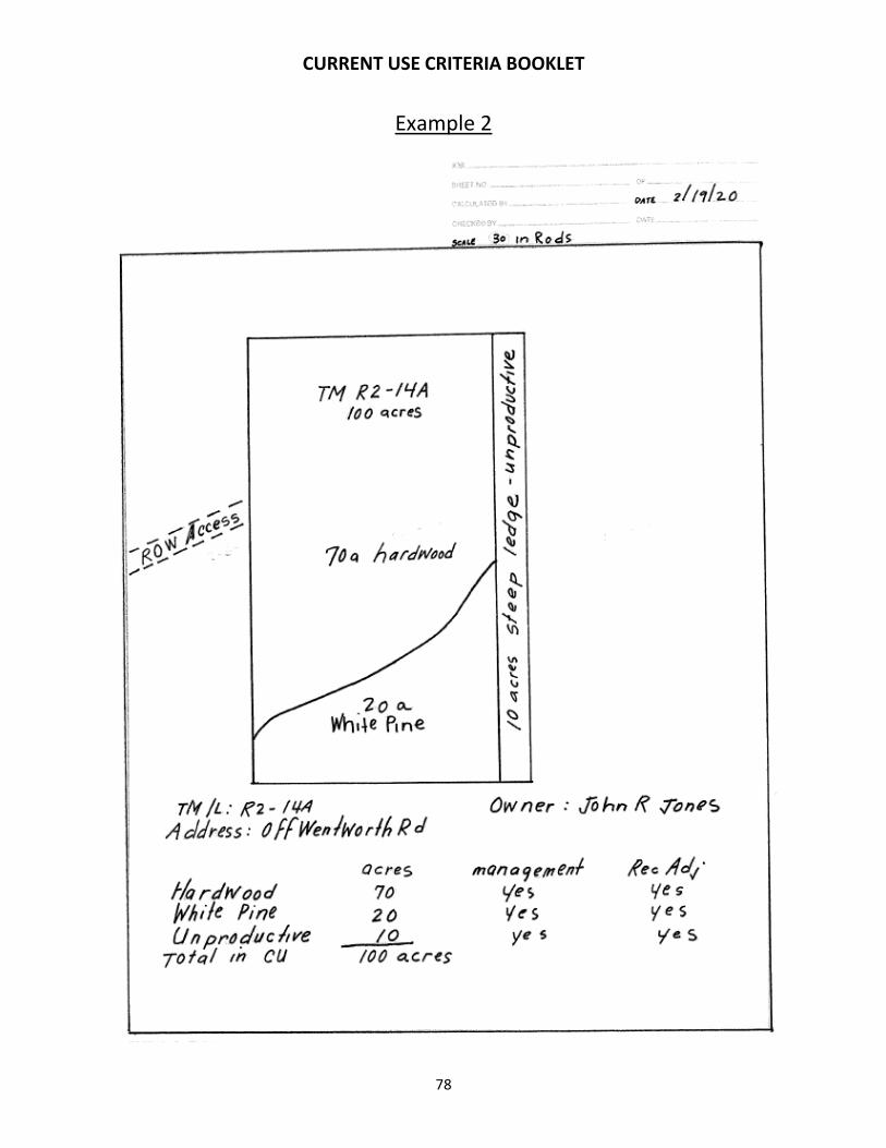
78
CURRENT USE CRITERIA BOOKLET
Example 2

79
CURRENT USE CRITERIA BOOKLET

80
CURRENT USE CRITERIA BOOKLET

81
CURRENT USE CRITERIA BOOKLET

82
CURRENT USE CRITERIA BOOKLET
Example 3

83
CURRENT USE CRITERIA BOOKLET

84
CURRENT USE CRITERIA BOOKLET

85
CURRENT USE CRITERIA BOOKLET
Assessing Officials’ Responsibilities
1. The assessing officials shall notify the applicant no later than July 1st, or within 15 days if the application is filed after July 1st, of their decision to classify or refusal to classify that parcel of land. The notification shall be delivered to the applicant in person, or by mailing such notification to his last and usual place of abode (RSA 79-A:5,III).
2. By August 1st, the assessing officials shall file with the county registry of deeds the notice of contingent lien describing all parcels of land classified under current use (RSA 79-A:5, VI) and the original application form. (Cub 309.03.).
3. Current Use applications and maps shall be retained by the municipality until the property is removed from current use plus 3 years pursuant to RSA 33-A:3-a XXVII.
4. Assessing officials should periodically review the current use properties in their town to make sure the property still meets all the qualifications. If there are any missing, incorrect or incomplete information, they should attempt to obtain the correct or missing information.
Tax Collector’s Responsibilities
1. Assessing officials shall submit to the tax collector a: a. Form A-5, Land Use Change Tax, and b. Form A-5W, Land Use Tax Collector’s Warrant, which will serve as a warrant with which
the tax collector shall collect the tax. 2. Upon receipt of Forms A-5 and A-5W, the tax collector shall:
a. Complete their portion of the Form A-5 and b. Mail the duplicate copy of the land use change tax bill to the property owner, or pursuant
to RSA 79-A:7, II, the responsible party within 18 months of the date the municipal assessing officials receive notice of the change of use from the landowner or their agent, or within 18 months of the date the municipal assessing officials actually discover that the land use change tax is due and payable.
3. Upon receipt of the payment of the land use change tax and the recording fee, the tax collector shall:
a. Sign Form A-5 acknowledging payment of the land use change tax; and b. Forward the original Form A-5 to the county registry of deeds in which it is located with
the recording fee. 4. If the land use change tax, together with the recording fees due the register of deeds is not paid
within 30 days of the mailing of the tax bills: a. Interest at the rate of 18 percent per annum shall be due; b. Such liens shall continue for a period of 24 months following the date …and c. The tax collector shall follow the statutory collection proceedings against real estate as
prescribed by RSA 80.
RECOMMENDED PRACTICE FOR MISSING OR INADEQUATE MAP
The assessing officials should contact the landowner and request a new map. If the landowner does not provide a map, the assessing officials may prepare a map showing their best estimate of what is in and out of current use and send it to the landowner for their review.

86
CURRENT USE CRITERIA BOOKLET
Contingent Lien
The notice of contingent lien serves as a notice to all interested parties that a lien on the land will be created if and when the land is changed to a non-qualifying use.
Land Classifications
Farmland
Soil Potential Index (SPI) Definition The Soil Potential Index (SPI) is a tool to be used by the assessing officials to determine where in the farmland range of values, a specific property should be assessed. The SPI is a numerical rating of a soil's relative suitability for growing corn silage and grass legume hay in New Hampshire. These two crops were selected by agricultural specialists as being the two most representative crops grown in the state, from North to South and would be the best crops to use as indicators of a soil's ability to be farmed. Whether or not the soils in a particular region of the state are currently being used to grow such crops, all soil is evaluated equally on their agricultural potential if the soils were planted to these crops.
How to get your Soil Potential Index
1. The SPI may be obtained from the landowner’s County Conservation District Office. Conservation Districts may charge a small fee for calculating the SPI. Landowners should first determine from their assessing officials where within the range of assessments their property is placed, then get an SPI, and then determine if using an SPI is beneficial to them. To find your County Office go to http://www.nhacd.net/member-districts.html. If the County Conservation District Office is unable to immediately provide the SPI for a particular parcel of land, they will provide a letter to the landowner stating that the SPI will be forthcoming. The landowner should give this letter to the assessing officials as notification that an SPI will be provided for this land. When the landowner receives the SPI, he should forward it to the assessing official so it may be applied in the farmland assessment calculation.
2. Once the landowner has provided the SPI, the assessing officials will apply the SPI to the assessment calculation until such time as a revised SPI is provided.
3. Cub 304.04(b) provides the formula for assessing farmland. Assuming an SPI of .60, the formula would calculate as follows:
High end of farmland range $425 Low end of farmland range - $25 Difference $400 Sample SPI of .60 x .60 Subtotal $240 Low end of range added back +$25 Per acre assessed value $265
4. The landowner must provide the SPI to the assessing officials in order for the assessors to apply it. Otherwise, the assessing officials may use their own discretion when assigning a valuation within the farmland assessment range.
WHERE TO GET YOUR SPI
Farmland owners should reach out to their County Conservation District Office. To find your County Office go to http://www.nhacd.net/member-districts.html.

87
CURRENT USE CRITERIA BOOKLET
Agricultural Buildings
1. The assessing officials shall apply Cub 303.02, the definition of building lot, when determining how much land must be left out of current use or removed from current use due to the presence of a building for agricultural purposes. The assessing officials must determine:
a. How much land is actually taken up by the building (the footprint of the building), and b. How much contiguous land around the building is groomed, maintained or needed to
support the building? (Also referred to as the curtilage.)
Assessment Ranges
1. Current Use ranges are assessed each year by the Current Use Board. See Current Use Board Responsibilities in this booklet for more information. See Assessment Ranges in this booklet for current ranges.
Forest Land
Classification of Forest Land
1. Forest land has 3 classifications of land: White Pine, Hardwood, and All Other. Each of the 3 classifications has 2 ranges of values: one range which reflects the cost of stewardship and one range which does not reflect the cost of stewardship. The costs associated with stewardship are hard to average as different landowners and sizes of parcels incur differing costs, however the Current Use Board has determined that there is a cost that needs to be accounted for. Therefore, if forest land is to be assessed within the ranges under “Forest Land with Documented Stewardship,” then the landowner must provide documentation in Cub 304.07 supporting the assessment within this range. If the forest land is to be assessed within the ranges not reflecting the cost of stewardship, the documentation listed under Cub 304.07 is not necessary.
2. Note: After an original application for current use has been approved, local assessing officials may require the landowner to justify assessments within the “Forest Land with Documented Stewardship” category at intervals of 5 years or more. Form CU-12, Summary of Forest Stewardship Plan for Current Use Assessment, summarizing the contents of the Forest Stewardship Plan, may be submitted at such time in lieu of the Forest Stewardship plan.
How are the Forest Land Rates Determined?
The forest land range of values is determined by a subcommittee of the Current Use Advisory Board who uses a Forest Land Values Model. The Forest Land Values Model includes current information and data of market activities in the state such as prices for forest land products, growth rate estimates, market investor expectations, and risk and size of investment factors. A 5-year rolling average is applied to minimize volatility in the ranges. The forest land without stewardship values are a percentage of the forest land with stewardship values.
LAND NOT IN CURRENT USE
Land that should not be included in the current use assessment include roads (unless used for agricultural, recreation, watershed and forestry purposes only), curtilage around buildings, permanent buildings, driveways, wells, septic systems, and landowner utility lines.

88
CURRENT USE CRITERIA BOOKLET
Assessment within the Range
1. Each of the forest land classifications has a per acre range of value. Not all forest land should be assessed at the high end of the range, or at the low end. Factors that influence the value of forest land include, but are not limited to:
a. Location of the land b. Accessibility of the forest products, and c. The severity of the terrain.
Under the definition of “current use value,” the assessor is required to determine the valuation in accordance with the “class, grade, type and location of the land” (RSA 79-A:2,V). Cub 304.05 provides definitions of these terms, and a definition of “site quality.” The assessor must consider all these factors when determining where, within the forest land range of values, a particular parcel of land falls (Cub 304.08).
2. In the Board of Tax and Land Appeals (BTLA) decision with the Town of Marlow (2001, Docket No. 18478-01RA) the BTLA specifically addressed the requirement that municipal officials consider the characteristics listed above to justify the assessment within the forest land ranges. In their decision, the BTLA suggested several methods to justify these assessments including the use of a simple matrix or the use of county soil and topographical maps. A version of a matrix is included in this booklet in the Forms section.
3. If a landowner is dissatisfied with the assessor’s determination and wishes to challenge the forest land assessment, Cub 304.10 provides two methods of providing additional information to support their challenge to the assessors. If the landowner is still dissatisfied with their assessment, the property tax appeal procedures under RSA 76:16, 76:16-a, 76:16-d, II, and 76:17 should be followed.
Clear Cutting
1. Forest land that has been subjected to clear cutting still qualifies as forest land (Cub 304.05 (d)).
Unproductive Land
Assessment
1. Unproductive land is land that does not meet the definition of forest land or farmland. Unproductive land is “incapable of producing agricultural or forest products due to poor soil or site characteristics, or the location of which renders it inaccessible or impractical to harvest agricultural or forest products.” Wetland is included in the unproductive land classification.
Reclassification
1. Land classified as unproductive land must be reclassified to forest and/or farmland if the land becomes accessible or practical to harvest (Cub 306.02(a)).
EXAMPLES OF UNPRODUCTIVE LAND
Wetlands, cliffs, ledges, or totally inaccessible land.
ROADS IN CURRENT USE
Roads used for agricultural, recreation, watershed and forestry purposes only can be included in current use. See RSA 79 A:7 IV (a), Cub 304.02 (b) and Cub 304.05 (c).

89
CURRENT USE CRITERIA BOOKLET
Wetland
1. Wetlands shall be those areas of farm, forest and unproductive land that are inundated or saturated by surface water or groundwater at a frequency and duration sufficient to support, and that under normal circumstances do support, a prevalence of vegetation typically adapted for life in saturated soil conditions. This definition mirrors the Department of Environmental Services definition. However, wetlands for current use purposes has two additional requirements:
a. The land must be incapable of producing agricultural or forest products due to poor soil or site characteristics, or the location of which renders it inaccessible or impractical to harvest agricultural or forest products and,
b. Wetlands must be left in their natural state without interference with the natural ecological processes.
Other Assessment Issues
Buildings in Current Use
1. Buildings, appurtenances, or other improvements on current use land shall not be assessed at current use values (RSA 79-A:5, 1). Appurtenances and improvements include driveways, groomed areas, wells, septic systems and utility lines for the landowner’s own use (Cub 303.05). Buildings, appurtenances and other improvements shall be assessed at ad valorem value (RSA 75:1).
Equalization of Current Use Land
1. The median ratio must be applied to all farm, forest and unproductive land assessments (RSA 79-A:5,1). To calculate the equalized current use value, the current use assessment is multiplied by the median ratio.
Gravel Pits
1. The removal of topsoil, gravel or minerals is prohibited on land in current use; such activity would constitute a change in land use and would subject the land to the land use change tax (RSA 79-A:7, IV(b)). The only exceptions to this rule are:
a. Removal of topsoil in the process of harvesting a sod farm crop in amounts that would not deplete the topsoil;
b. Removal of gravel and other material for construction and maintenance of roads and land for agricultural or forestry purposes within the qualifying property of the owner, or with the approval of local authorities, to other qualifying property of the owner.
WET FARMLAND AND FORESTLAND
If a wetland property meets the criteria for the farm or forest categories, it must be classified as farmland or forest land for current use purposes. In fact, some of the best farmland with the highest SPI may be located in floodplains or other area designated by DES as wetlands.

90
CURRENT USE CRITERIA BOOKLET
Posting of Current Use Land
1. Land assessed under current use may be posted “No Trespassing” or other signs, unless landowner applies for the 20% recreational adjustment. Receiving current use assessment does not require a landowner to open the property to public use, unless landowner also receives the 20% recreational adjustment.
20% Recreational Adjustment
1. If a landowner decides not to post “No Trespassing” and opens the property to public use without an entrance fee for 12 months a year, the land is entitled to a 20% reduction in the current use assessment of the acres opened to public recreational use. To receive the 20% recreation adjustment, the landowner must allow all of the following activities:
a. Hunting, b. Skiing, c. Fishing, d. Snowshoeing, e. Hiking, and f. Nature Observation.
2. If any of these activities are detrimental to a specific agricultural or forest crop, that activity may be prohibited. If the 20% recreational adjustment has been granted, posting to prohibit any activity listed above requires approval of the local assessing officials. See Cub 304.02 for further explanation.
3. The landowner may prohibit trespass upon his property for all other activities, including use of mechanized and off-highway vehicles (such as snowmobiles and all-terrain vehicles-ATV), camping, cutting down trees, etc. Posting land to prohibit these activities will not affect the 20% recreation adjustment.
Zoning Requirements
1. For all classifications of current use land, the dimensions of a building lot shall not be governed by any local or planning ordinances. For example, an 11-acre parcel of forest land in a municipality that requires a minimum of 2 acres for a building lot, may still qualify for current use assessment. If the building lot, as defined under Cub 303.02, occupies ½ an acre, then 10 ½ acres would qualify for current use assessment regardless of the 2-acre zoning requirement.
EXCEPTIONS
The municipal assessing officials may make an exception to the 20% recreational adjustment for landowners who have a temporary safety concern. Examples of these exceptions include, but are not limited to, a pesticide application or large timber harvest. Landowners who repeatedly need to request exceptions should consider removing the land from the recreational category.
NH FISH & GAME SIGN PROGRAM
Landowners who keep part of their lands open for hunting, may qualify for free access management signs through NH Fish and Game’s Landowner Relations Program. More information can be found at www.wildnh.com/landshare.

91
CURRENT USE CRITERIA BOOKLET
The Land Use Change Tax
Rate
1. The land use change tax is “10% of the full and true value” of the land that no longer qualifies for current use (RSA 79-A:7). The 10% land use change tax is not based upon the amount of taxes saved over the years in which the property was in current use. As with all ad valorem assessments, “full and true value” may or may not be the same as the selling price of the property.
2. The “full and true value” of the land is based on the highest and best use of the land as of the date and actual physical change was begun, as long as the requirements of RSA 79-A:7 V (a) are met. Otherwise, the local assessing officials may wait and base the land use change tax upon the land’s full and true value at a later time after the requirements of RSA 79-A:7 V (a) have been met, regardless of the date of the actual physical change.
3. In the April 12, 2000, decision of the Appeal of the Estate of Richard Van Lunen, the New Hampshire Supreme Court interpreted Cub 308.02 to require that “…the value of any betterment to the land not be included in determining the lands full and true value when it is removed from current use.” Because this interpretation was contrary to the intent of the rule, the Current Use Board amended Cub 308.02 to clarify that “The full and true value of the land being disqualified pursuant to RSA 79-A:7, shall be based upon the highest and best use of the land, including the value of all betterments serving the land.” The Board also defined “betterment” to mean “the installation or construction of improvements which influence the value of the land such as roads, water lines, utility lines or other physical improvements” (Cub 301.02).
Assessment
1. Land may only be removed from current use for the reasons described in RSA 79-A:7 III, IV, and V and Cub 307.01. Otherwise, land remains in current use. There are no buy-out options.
Amount of Land to be Taxed
1. When a parcel of land is being developed, only the amount of land that has been physically changed shall be removed from current use as long as the landowner retains enough land to meet the current use minimum acreage requirements in Cub 304.01. For land that is developed as condominiums and planned unit/cluster developments where common land is used to satisfy density requirements, other specific rules apply. See RSA 79-A:7, V(b), Cub 307.02, and Cub 307.03.
Land Use Change Tax Bill
1. The land use change tax bill shall be assessed and mailed within 18 months of the date the local assessing officials are either notified by the landowner of a change in use or they discover that a change in use has occurred.
CHANGE IN OWNERSHIP
If a parcel of property in current use is transferred to a new owner and still qualifies for current use, the property shall remain in current use. There is no requirement for the new owner to apply for current use assessment.
CHANGE IN CATEGORY
If a parcel changes category (for example, farmland turned to forestland or vice versa), the change should not trigger a new application and fee. Changes should be noted in town’s records and could include an updated application or map.

92
CURRENT USE CRITERIA BOOKLET
2. The assessment of the land use change tax creates a lien per RSA 79-A:7 II (e) upon the landowner’s property and is subject to statutory collection proceedings against real estate as prescribed in RSA 80. Therefore, it is imperative that the land use change tax be paid in full even if the landowner intends to request an abatement of the tax. The tax is due 30 days from the date the bill was mailed. Interest of 18% per annum shall be due on any tax not paid within the 30-day period.
3. Upon payment of the land use change tax, the bill is forwarded to the county registry of deeds for recording. This recording releases the contingent lien placed upon the property when the current use application was recorded. The landowner is responsible for the recording fee as prescribed by RSA 478:17-g in addition to the land use change tax.
4. Current use release forms shall be retained by the municipality permanently pursuant to RSA 33-A:XXIX.
Appeal Procedures
1. Any landowner who disagrees with the assessment of the land use change tax has the same rights of appeal as for real property taxes pursuant to RSA 76:16, 76:16-a, 76:16-d, II and 76:17. The landowner must apply in writing to the assessors within 2 months of the date of notice of the tax, for an abatement of the tax. If the assessors refuse or neglect to abate the tax, the landowner may apply for abatement to either, the Board of Tax and Land Appeals or to the County Superior Court. This appeal must be filed within 8 months of the tax.
2. Land use change tax abatement forms for appealing to the municipality or to the Board of Tax and Land Appeals are available from the BTLA at https://www.nh.gov/btla/forms/index.htm. For forms or further information concerning appeal of the Land Use Change Tax, contact the Department of Revenue Administration, Municipal and Property Division by mail at PO Box 487, Concord, NH 03302-0487, or by phone at (603)230-5950. Forms can also be obtained by visiting the website: www.revenue.nh.gov/forms.
RECOMMENDED PRACTICE FOR WRONG CLASSIFICATION
If a property was incorrectly classified, it is recommended that Form CU-18 be completed by either the municipal assessing officials or the landowner that discovered the change needed. Adjustments should be made to correct the map and make corrections to the assessment records. Unintentional errors by landowners or municipal assessing officials should not trigger land use change tax.

93
CURRENT USE CRITERIA BOOKLET
Supplemental Statutes
Note: The following statutes provided in this booklet, while believed to be accurate, are provided for informational purposes only. The statutes, taken from the State of New Hampshire website, are based on updates as of January 1, 2017. For the official version of any statute, please consult the bound volumes and supplements of the New Hampshire Revised Statutes Annotated, published by West, a Thomson business. Complete copies of RSA 79-A and RSA 212:34 with source notes can be found on the State of New Hampshire website: www.nh.gov/government/laws.html.
The following statutes are referred to in RSA 79-A. All New Hampshire statutes are available at www.nh.gov.
RSA 21-J:1-a Boards Administratively Attached. – Referenced in 79-A-3 The following boards shall be administratively attached to the department of revenue administration, under RSA 21-G:10: I. The current use board, established under RSA 79-A:3. II. The assessing standards board, established under RSA 21-J:14-a. RSA 28:7-b Planning and Zoning in Unincorporated Towns and Unorganized Places. – For each unincorporated town or unorganized place, the county in which it is located and its commissioners shall have the same responsibilities and powers to exercise planning, zoning, subdivision and related regulations as city and local land use boards. Regulations shall be exercised in accordance with the provisions of RSA 672-677 to the extent practical, in order to ensure reasonable development and planning in the unincorporated town or unorganized place.
RSA 33:4-b Debt Limit; Computation. – Referenced in RSA 79-A:6
The debt limitations hereinbefore prescribed, except for counties, shall be based upon the applicable last locally assessed valuation of the municipality as last equalized by the commissioner of revenue administration under RSA 21-J:3, XIII and shall include the equalized value of property formerly taxed pursuant to the provisions of RSA 72:7; 72:15, I, V, VII, VIII, IX, X and XI; 72:16; 72:17; 73:26; 73:27 and 73:11 through 16 inclusive, all as amended, which was relieved from taxation by 1970, 5:3, 5:8 and 57:12, as determined under the provisions of RSA 71:11 as amended. Whenever several municipalities possessing the power to incur indebtedness cover or extend over identical territory, each such municipality shall so exercise the power to incur indebtedness under the foregoing limitations so that the aggregate net indebtedness of such municipalities shall not exceed 9.75 percent of the valuation of the taxable property as hereinbefore determined, except as provided for cooperative school districts under RSA 195:6. A written certificate signed by the commissioner of the department of revenue administration shall be conclusive evidence of the base valuation of municipalities for computing debt limits hereunder.
RSA 36-A:5 Appropriations Authorized. – Referenced in RSA 79-A:25 I. A town or city, having established a conservation commission as authorized by RSA 36-A:2, may appropriate money as deemed necessary for the purpose of this chapter. The whole or any part of money so appropriated in any year and any gifts of money received pursuant to RSA 36-A:4 may be placed in a conservation fund and allowed to accumulate from year to year. Money may be expended from said fund by the conservation commission for the purposes of this chapter without further approval of the town meeting. II. The town treasurer, pursuant to RSA 41:29, shall have custody of all moneys in the conservation fund and shall pay out the same only upon order of the conservation commission. The disbursement of

94
CURRENT USE CRITERIA BOOKLET
conservation funds shall be authorized by a majority of the conservation commission. Prior to the use of such funds for the purchase of any interest in real property or for a contribution to a qualified organization for the purchase of property interests under RSA 36-A:4-a, I(b), the conservation commission shall hold a public hearing with notice in accordance with RSA 675:7. III. In the municipality that has adopted the provisions of RSA 79-A:25, II, the specified percentage of the revenues received pursuant to RSA 79-A shall be placed in the conservation fund.
RSA 71-B:12 Appeal. – Referenced in RSA 79-A:9 VI
Decisions of the board may be appealed by either party only in accordance with the provisions of RSA 541 as from time to time amended; provided, however, that there shall be only one appeal allowed per person on each parcel of land until such time as a reassessment has been made.
RSA 72:11 Water Works; Flood Control. – Referenced in RSA 79-A:2 IX I. Except as provided in paragraph II, property held by a city, town or district in another city or town for the purpose of a water supply or flood control, if yielding no rent, shall not be liable to taxation therein, but the city, town or district so holding it shall annually pay to the city or town in which such property lies an amount equal to that which such place would receive for taxes upon the average of the assessed value of such land, without buildings or other structures, for the 3 years last preceding legal process to acquire the same, or other acquisition thereof, the valuation for each year being reduced by all abatements thereon; but any part of such land or buildings from which any revenue in the nature of rent is received shall be subject to taxation; such payments shall be paid to the collector of taxes of the town or city in which such property lies upon notification from him, and such payment shall be made on or before December 1 in each year; provided, however, that after such acquisition the valuation thus established shall be subject to change, as to make such value proportional with the assessed value of other property in the town which is subject to taxation, so that such payment will not exceed its proportion of the public charge in that year. Any city or town aggrieved by the payment in lieu of taxes on such property shall have the same right of appeal as a taxpayer may have. II. (a) Alternatively, the governing body of a city, town, or district holding property described in paragraph I may enter into an agreement with the governing body of the city or town in which the property is located for payments in lieu of taxes with respect to the subject property. In the absence of such an agreement, the property shall be subject to the provisions of paragraph I. Notwithstanding any agreement entered into under this paragraph, any portion of the land or buildings from which revenue in the nature of rent is received shall remain subject to taxation as provided in paragraph I. (b) No voluntary agreement entered into under this paragraph shall be valid for more than 5 years, however, any such agreement may be renewed or amended and restated for any number of consecutive periods of 5 years or less.
RSA 74:4 Taxpayer Inventory Blank. – Referenced in RSA 79-A:5 V-a I. The taxpayer inventory blank shall be designed to obtain the necessary information in a manner which is convenient for the person completing it. The printing on it shall be at least 10 point type. II. The blank shall require the person or corporation to be taxed to provide the required information under penalty of perjury. The blank shall require the taxpayer to sign in one place for all information submitted, including any application for eligibility for exemptions. III. The blank shall require the following information: (a) A description of all real estate taxable to the person or corporation; (b) Other information needed by the assessing officials to assess all the taxable property of the person or corporation at its true value; (c) A census of all persons occupying the premises as of April 1, by name and age. IV. The blank shall include the following statement:

95
CURRENT USE CRITERIA BOOKLET
"You may be entitled to the following tax relief: Elderly or Disabled Tax Lien, or an Abatement. For additional information, contact your selectmen or assessor.'' V. The blank shall require owners of land classified as open space to indicate whether any changes in the use of the land have been made. VI. The blank shall require owners of land classified as land under qualifying farm structures under RSA 79-F to indicate whether any changes in use of the land have been made. VII. The blank shall require owners of a qualifying historic building under RSA 79-G to indicate whether any changes in use of the qualifying historic building have been made. VIII. The blank shall require owners of property rented or leased to a qualifying chartered public school facility under RSA 79-H to indicate whether any changes in use of the qualifying chartered public school facility have been made.
RSA 75:1 How Appraised. – Referenced in RSA 79-A:7 II
The selectmen shall appraise open space land pursuant to RSA 79-A:5, open space land with conservation restrictions pursuant to RSA 79-B:3, land with discretionary easements pursuant to RSA 79-C:7, residences on commercial or industrial zoned land pursuant to RSA 75:11, earth and excavations pursuant to RSA 72-B, land classified as land under qualifying farm structures pursuant to RSA 79-F, buildings and land appraised under RSA 79-G as qualifying historic buildings, qualifying chartered public school property appraised under RSA 79-H, residential rental property subject to a housing covenant under the low-income housing tax credit program pursuant to RSA 75:1-a, renewable generation facility property subject to a voluntary payment in lieu of taxes agreement under RSA 72:74 as determined under said agreement, and all other taxable property at its market value. Market value means the property's full and true value as the same would be appraised in payment of a just debt due from a solvent debtor. The selectmen shall receive and consider all evidence that may be submitted to them relative to the value of property, the value of which cannot be determined by personal examination.
RSA 76:2 Property Tax Year. – Referenced in RSA 79-A:7 I The property tax year shall be April 1 to March 31 and all property taxes shall be assessed on the inventory taken in April of that year, except for prorated assessments on damaged buildings under RSA 76:21.
RSA 76:7 Record of Inventories and Taxes. – Referenced in RSA 79-A:5 IV
A fair record shall be made of every inventory taken by the selectmen and of all taxes by them assessed, in a book of records of the doings of the selectmen in their office, which shall be the property of the town. If the selectmen or assessors do not have an office which is open to the public 5 days a week during normal business hours at which time any person may inspect the current tax records of the town or city, then the selectmen or assessors shall leave a copy of the record with the town clerk within 30 days after the tax rate has been approved by the commissioner of revenue administration, or the original inventory and assessment shall be so left and recorded by the clerk. Both records shall be open to the inspection of all persons. The inventory record shall contain: (1) the information required under RSA 75:4; (2) the record of real estate which shall include the name of the owner, if known; the number of the lot and range, if lotted; otherwise, such description as the land may readily be known by; and the number of acres, if known; and (3) the amount of taxes assessed on all property assessed.
RSA 80:85 Lien Procedure; Land Use Change Tax. – Referenced in RSA 79-A:7 :7
All land use change tax assessments levied under RSA 79-A:7 shall, on the date of the change in use, create a lien upon the lands on account of which they are made and against the owner of record of the said land. Furthermore, such liens shall continue for a period of 24 months following the date upon which the local assessing officials receive written notice of the change in use from the landowner or his

96
CURRENT USE CRITERIA BOOKLET
agent, or the date upon which the local assessing officials actually discover that the land use change tax is due and payable, and such assessment shall be subject to the real estate tax lien procedure by the tax collector prescribed by RSA 80:59.
RSA 541-A:1 Definitions. – Referenced in RSA 79-A: 4 IV
In this chapter: I. "Adjudicative proceeding'' means the procedure to be followed in contested cases, as set forth in RSA 541-A:31 through RSA 541-A:36. II. "Agency'' means each state board, commission, department, institution, officer, or any other state official or group, other than the legislature or the courts, authorized by law to make rules or to determine contested cases. III. "Committee'' means the joint legislative committee on administrative rules, unless the context clearly indicates otherwise. IV. "Contested case'' means a proceeding in which the legal rights, duties, or privileges of a party are required by law to be determined by an agency after notice and an opportunity for hearing. V. "Declaratory ruling'' means an agency ruling as to the specific applicability of any statutory provision or of any rule or order of the agency. V-a. "Electronic document'' means a document which complies with requirements established in the drafting and procedures manual under RSA 541-A:8. For electronic documents, a requirement during the rulemaking process for a signature accompanying the filing of an electronic document shall be met if such signature complies with the requirements of RSA 294-E. VI. "File'' means the actual receipt, by the director of legislative services, of a paper or electronic document required to be submitted during a rulemaking process established by this chapter. The term "file'' shall also apply to any other response, submission, or written explanation required during a rulemaking process established by this chapter. VI-a. "Final legislative action'' means the defeat of a joint resolution sponsored by the legislative committee on administrative rules pursuant to RSA 541-A:13, VII(b) in either the house or the senate, or the failure of the general court to override the governor's veto of the joint resolution. VII. "Fiscal impact statement'' means a statement prepared by the legislative budget assistant, using data supplied by the rulemaking agency, and giving consideration to both short- and long-term fiscal consequences and includes the elements required by RSA 541-A:5, IV. VII-a. "Form'' means a document that establishes a requirement for persons outside the agency to provide information to an agency and the format in which such information must be submitted. The term does not include any document, regardless of what the document is called, that (a) is provided by an agency to facilitate the submission of information that is required to be submitted to the agency by federal or state statute, regulation, or rule and does not add to or modify such requirement or (b) that is used only by the agency to provide information to persons outside the agency. VII-b. "Internet content'' means material that exists only on a website on the Internet. VIII. "License'' means the whole or part of any agency permit, certificate, approval, registration, charter or similar form of permission required by law. IX. "Licensing'' means the agency process relative to the issuance, denial, renewal, revocation, suspension, annulment, withdrawal or amendment of a license, or the imposition of terms for the exercise of a license. X. "Nonadjudicative processes'' means all agency procedures and actions other than an adjudicative proceeding. XI. "Order'' means the whole or part of an agency's final disposition of a matter, other than a rule, but does not include an agency's decision to initiate, postpone, investigate or process any matter, or to issue a complaint or citation.

97
CURRENT USE CRITERIA BOOKLET
XII. "Party'' means each person or agency named or admitted as a party, or properly seeking and entitled as a right to be admitted as a party. XIII. "Person'' means any individual, partnership, corporation, association, governmental subdivision, or public or private organization of any character other than an agency. XIV. "Presiding officer'' means that individual to whom the agency has delegated the authority to preside over a proceeding, if any; otherwise it shall mean the head of the agency. XV. "Rule'' means each regulation, standard, form as defined in paragraph VII-a, or other statement of general applicability adopted by an agency to (a) implement, interpret, or make specific a statute enforced or administered by such agency or (b) prescribe or interpret an agency policy, procedure or practice requirement binding on persons outside the agency, whether members of the general public or personnel in other agencies. The term does not include (a) internal memoranda which set policy applicable only to its own employees and which do not affect private rights or change the substance of rules binding upon the public, (b) informational pamphlets, letters, or other explanatory material which refer to a statute or rule without affecting its substance or interpretation, (c) personnel records relating to the hiring, dismissal, promotion, or compensation of any public employee, or the disciplining of such employee, or the investigating of any charges against such employee, or (d) declaratory rulings. The term "rule'' shall include rules adopted by the director of personnel, department of administrative services, relative to the state employee personnel system. Notwithstanding the requirements of RSA 21-I:14, the term "rule'' shall not include the manual described in RSA 21-I:14, I or the standards for the format, content, and style of agency annual and biennial reports described in RSA 21-I:14, IX, which together comprise the manual commonly known as the administrative services manual of procedures. The manual shall be subject to the approval of governor and council. XVI. "Standing policy committee'' means a committee listed in rules of the house of representatives or the senate to which legislation including rulemaking authority was originally referred for hearing and report.

98
CURRENT USE CRITERIA BOOKLET
Soil Potential Index Addendum
The SPI is derived from indexes of soil production, cost of corrective measures, and the cost for continuing limitations. The SPI can be expressed by the equation: SPI = P -(CM+CL), where P is the index of production or yield capability, CM is the index of costs to apply corrective measures to overcome soil limitations and CL is the index of costs resulting from continued limitations. These calculations are completed for soils using corn silage as the indicator crop, and completed a second time using grass legume hay as the indicator crop. The resulting two values are then averaged to arrive at the final SPI value. In order to array all of the soils in New Hampshire according to their agricultural potential, a yield production standard was determined and assigned an SPI value of 100. The advantage to setting a production standard at 100 is that the best agricultural soils in the state will have an SPI of 100 and all other soils arrayed in descending values. Ranking all soils from best to worst on a scale of 100 to 0, provides an easy to understand basis for comprehending relative suitability.
This process of determining SPI has resulted in a consistently applied evaluation process that is scientifically sound and legally defensible. This is not to say that current SPI values will never need further refinement. As the soil science community continues to make technological advancements and expands the knowledge base from which soil behavioral characteristics are determined, there will most likely be a need to re-visit the current SPI system.
Production Standard
The production standard was established and defined by a committee of agricultural specialists. The standard used in New Hampshire is that soil which has those soil properties that assure the highest yield. The standard soil for corn silage and grass legume hay is a well-drained, moderately permeable soil that does not have rock fragments in the surface layer. It is very deep to bedrock, has a high available water holding capacity, is on a slope of less than 3 percent, and has a mean annual temperature at 20 inches greater than or equal to 47 degrees F (mesic). This combination of soil properties will produce the highest yields per acre and the soil has the capacity for sustained high production, year to year, without applying any corrective measures under good management and without damaging the resource base. The production standard in New Hampshire assumes that the soil is intensively managed for corn silage or grass legume hay. Farming operations are timely, lime and fertilizer are applied according to soil analysis, and soil erosion is kept at or below the allowable soil loss value.
Soil Evaluation Factors
Seven soil evaluation factors are used to determine soil potential ratings. The evaluation factors include slope, available water holding capacity in the upper 40 inches, depth to bedrock, rock fragments in the surface layer, water table level, soil permeability, and mean annual soil temperature. Each of these factors may have detrimental effects that can impact the production of corn silage and grass legume hay in New Hampshire. Other soil factors were considered in the evaluation process such as flooding hazard, soil pH, and contrasting inclusions within soil map units. After lengthy review by a committee of agricultural specialists, it was determined these factors should not be used either because there is little overall impact on agricultural land, there is very little variation in New Hampshire soils and the incorporation of these factors into the evaluation process would add considerable complexity and the end result would not significantly change the overall ranking, or SPI, of the soil.

99
CURRENT USE CRITERIA BOOKLET
SPI and Prime Farmland
For many years, the USDA Soil Conservation Service has defined and identified prime farmland soils. These soils are considered to be the best soils for the production of food and fiber. Prime farmland soils in New Hampshire have a range in SPI ranking from 68 to 100 which gives the appearance of inconsistency when some prime farmland soils are rated at 100 and others only at 68. Although there appears to be an apparent conflict, one needs to keep in mind the difference in the process used to arrive at the different ratings and what they mean. The most significant difference between the two rating systems is that the economics of overcoming soil limitations and costs of continuing limitations are not factors in the determination of prime farmland, but is a major factor in determining SPI. Also, one needs to keep in mind that the SPI number assigned to any soil has no real meaning or value except to provide a relative placement among all soils in the state. The SPI rating system uses a much finer breakdown in soil physical properties than does the prime farmland rating system. For example, for a soil to qualify as prime farmland, the soil either "has no water table, or has a water table that is maintained at a sufficient depth during the growing season to allow cultivated crops common to the area to be grown".
In the SPI rating system, the water table factor is separated into eight divisions based on the severity of the limitation and any economic losses due to continuing limitations. Based on the water table factor alone, prime farmland soils can have an SPI value ranging from 100 to 78. If one adds to this, the cost factor of removing stones from year to year, and subtracting points for frigid temperature regime, the SPI's for some prime farmland soils can drop into the low 70's or upper 60's.
History of Soil Potential Index
The SPI method of placing farmland values within a range is not solely a NH activity; many states use the SPI method to place farmland with ranges of programs similar to NH’s Current Use program. Using an SPI gives municipalities, a legal, scientific, and defensible way to place farmland into the Current Use range; landowners will know that their land is being correctly placed within the categories. In 1974 the New Hampshire legislative session passed a long awaited and hard-fought-for Current Use Assessment Law (RSA 79-A). The purpose of this legislation was in the interest of reducing the conversion of open space to more intensive use and encouraging preservation of open space through property taxation based on current use. In order to apply equitable tax assessment to all open land, the New Hampshire Department of Revenue (DRA) adopted the soil potential index rating system (SPI) developed by the USDA Soil Conservation Service in 1988. This system, which ranks the soils of New Hampshire based on their agricultural suitability, was originally established for use in a Land Evaluation and Site Assessment (LESA) system for use as a planning tool by resource conservationists, planners and city and town officials. The Legislative Rules committee revised the definition of lands that fall under the current use law for the 1992 tax year, this created an incentive to enhance the SPI rating system for that year as well. The enhancement of the old system was conducted over an eight month period from October 1991 to May of 1992. Many of the basic principles developed in 1988 for the LESA system are still valid today for application in the soil potential index system and no attempt was made to adjust or revise this criteria. Many committees and groups of specialists were organized in 1988 to develop the initial ranking of soils

100
CURRENT USE CRITERIA BOOKLET
and no effort was made during this enhancement to revise the work accomplished by these committees.
Development of Soil Potential Ratings (SPI)
There are more than 1,700 different soil map units recognized in New Hampshire. All of the SPI ratings were calculated manually. Although the USDA Soil Conservation Service (SCS)has a soil properties database that stores physical property data, some of the criteria used in the SPI calculations required expert decisions not currently possible with present day technology. This manual process was completed by the SCS soils staff in Durham, New Hampshire and forwarded to eight soil scientists around the state for review and cross checking. Each soil was compared against similar soils with similar properties to assure similar SPls. Groups of soils occurring within small geographic areas were compared against one-another to assure reasonableness in the relative ranking. And all soils within a published soil survey area were reviewed for consistency and compatibility
Flood prone soils in New Hampshire do not normally flood during the growing season. Almost all of the soils in New Hampshire have similar soil reaction properties to 20 inches. Contrasting inclusions are expected components of every map unit; when assessing these inclusions for SPI, some have higher SPI values, some lower. After evaluating several map units based on type and extent of inclusions, it was determined that overall SPI ranking does not change appreciably from the SPI of the named soil.
Upland glacial till soils recognized as non-stony because the stones have been removed, cannot be easily separated in the database from soils that are inherently stone-free. Also, Tables 1A through 2F describe critical breaks in certain soil properties that are not easily discernable in the database. For example, available water holding capacity in the upper 40 inches of soil have critical breaks at 3.2 inches of water, 2.8 inches of water and 2.4 inches of water. Some of the soils recognized in New Hampshire are described as having a range that spans both sides of a critical break. In situations like this, the soil scientists researched actual field documentation and conferred on a decision to place this particular soil feature on one side of the critical break or the other.
SPI Corrective Measures and Continuing Limitations
Since the costs of corrective measures are total initial costs and costs resulting from continuing limitations are annual, economic analysis or amortization was used to derive a common basis for the corrective measures and continuing limitations. Amortization is sometimes called the partial payment or capital recovery factor. This factor will convert capital or initial cost to annual cost. It will determine what annual payment including interest must be made to pay off the initial cost over a given number of years.
For soils with yields less than the standard, the lower yield was considered a continuing limitation equal to a factor representing the amount of yield that was below the standard. This was necessary to account for a lower yield that was not overcome by corrective measures.
A committee of landowners, contractors and specialists provided data on costs for corrective measures and for most of the continuing limitations. All of the assumptions and sources of information were documented so that individuals who use the ratings would understand that some of the measures are not absolute measures of performance. Sloping land and high inherent erodibility (K) require measures to protect the soil against erosion. Protection can be provided through either no-till, a diversion system, strip-cropping, or crop rotation. The local committee estimated the costs for these corrective measures with the basic intent that each measure would ensure that erosion did not

101
CURRENT USE CRITERIA BOOKLET
exceed the allowable soil loss. Continuing limitations were identified as operation and maintenance costs and the cost resulting from reduced yields.
The cost for corrective measures for seasonal high water table and soil permeability were estimated using the New Hampshire Soil Conservation Service Drainage Guide. Three permeability groupings were used to calculate costs. These costs reflect subsurface tile drainage systems that have closer spacing as the soil permeability becomes less. The continuing limitation costs were identified as maintenance costs for the tile drainage system and the cost resulting from reduced yields.
Current state and federal land use regulations pertaining to wetlands were not considered in the calculation of SPI for the following reasons. The new SPI values are based on soil physical properties only; land-use regulations do not affect a soil's potential or suitability for a given use. Land-use regulations are subject to change which could result in dramatic variations in SPI values whenever the legislature was so inclined. Most wetlands in New Hampshire are not farmed and are classified as wildlife habitat and do not fall under current-use laws. There are a few areas of farmed wetlands in New Hampshire and those that are farmed obviously have some agricultural value.
Rock fragments in the surface layer are a very common limitation in the upland glacial till soils in New Hampshire. The typical corrective measure is removal of the large fragments that hamper tillage operations. After the corrective measure is complete, there is a continuing limitation of operation of equipment because rock fragments continue to work their way to the surface by frost action. The continuing limitation of stones is more severe when the land is planted to corn rather than hay because of the wear and tear on tillage implements.
There are no feasible corrective measures for some soil limitations such as available water holding capacity and depth to bedrock. For these soils, costs are based on reduced yields and treated as a continuing limitation. Since irrigation is not a typical corrective measure in New Hampshire, no corrective measure is assessed for the available water holding capacity soil limitation. Soils with low or very low available water capacity yield less than the standard, therefore the reduced yield is a continuing limitation. No corrective action is feasible to alter the depth to bedrock therefore the cost of reduced yields is used as a continuing limitation.
There are no corrective measures for soil temperature. It has been documented, however, that soils with a mesic soil temperature regime (mean annual soil temperature greater than or equal to 47 degrees F.) have higher yields for crop production than soils with a frigid soil temperature regime occurring in slightly colder climates if all of the other soil evaluation factors and soil and site conditions remain the same. Therefore, delayed planting and reduced yield are considered a continuing limitation for soils that have a frigid soil temperature. Some soils, in the higher elevations in New Hampshire have a temperature regime cold enough to be considered unsuitable for cropland. Some soil limitations such as steep slopes and extremely stony cover have no realistic corrective measure. A cost index is assigned as a continuing limitation for soils occupying these areas.
Deriving Corrective Measures and Continuing Limitations for SPI
Since amortization was used on the corrective measure cost, corrective measure costs are in effect annual costs. The continuing limitation costs are also annual costs. Therefore, the costs for calculating an SPI index are on an equal basis.

102
CURRENT USE CRITERIA BOOKLET
A committee of agricultural specialists accepted the "worst case-scenario" to derive indexes whereby all of the costs for corrective measures and continuing limitations were summed for the soil map unit with the most soil limitations.