Embed Size (px)
Citation preview

Current status of national spatial data
infrastructure development in African
countries
Part One
September 2019

i
Contents
Executive summary ................................................................................................................... iii
1. Introduction .......................................................................................................................... 1
2. Brief overview of the approaches recommended for national spatial
data infrastructure development in African countries ........................................................... 2
2.1.The mandatory national spatial data infrastructure development model ........................ 2
2.2.The product-based national spatial data
infrastructure approach ................................................................................................ 2
2.3. Adoption of an analyse/formulate/implement methodology ......................................... 3
3. Key indicators used in the assessment of national spatial data infrastructure
development in African countries ......................................................................................... 4
3.1. Component 1: Strategic plan ....................................................................................... 4
3.1.1. Shared vis .......................................................................................................... 4
3.1.2. Clearly articulated mission statement ................................................................. 4
3.1.3. Specific, measurable, achievable, realistic and time-bound
(SMART) objectives ................................................................................................... 4
3.2. Component 2: Policy and legal frameworks................................................................. 5
3.2.1. National spatial data infrastructure proclamation/directive ................................. 5
3.2.2. Lead organization .............................................................................................. 5
3.2.3. Data policy ........................................................................................................ 6
3.2.4. Funding ............................................................................................................. 6
3.3. Component 3: Fundamental data sets........................................................................... 6
3.3.1. Official list of fundamental data set ................................................................... 7
3.3.2. Availability of digital fundamental data sets ...................................................... 7
3.3.3.Metadata generation ........................................................................................... 7
3.4. Component 4: Standards.............................................................................................. 7
3.4.1.Data set standards ............................................................................................... 8
3.4.2.Metadata standards ............................................................................................. 8
3.5. Component 5: Access network .................................................................................... 8
3.5.1.Access to electricity ............................................................................................ 8
3.5.2.Information and Communications Technology Development Index .................... 9
3.5.3.Internet penetration ............................................................................................. 9
3.5.4.Establishment of a geoportal ............................................................................... 9
3.6. Component 6: People .................................................................................................. 9
3.6.1.Awareness of geospatial information/national spatial data infrastructure ........... 10
3.6.2.Geospatial information knowledge and skills .................................................... 10
3.6.3.Capacity and capability development ................................................................ 10
3.6.4.Partnerships ...................................................................................................... 10
3.7. Summary of the components and their corresponding indicators ................................ 11
4. Assessment data ................................................................................................................. 12
4.1. The questionnaire ...................................................................................................... 12
4.1.1.Component 1: Strategic plan ............................................................................. 12

ii
4.1.2.Component 2: Policy and legal frameworks ...................................................... 12
4.1.3.Component 3: Fundamental data sets ................................................................ 12
4.1.4.Component 4: Standards ................................................................................... 12
4.1.5.Component 5: Access network.......................................................................... 12
4.1.6.Component 6: People........................................................................................ 13
4.2. Response to the questionnaire.................................................................................... 13
5. Assessment methodology ................................................................................................... 14
6. Results of the assessment ................................................................................................... 16
6.1. Component 1: Strategic plan ..................................................................................... 16
6.2. Component 2: Policy and legal frameworks............................................................... 17
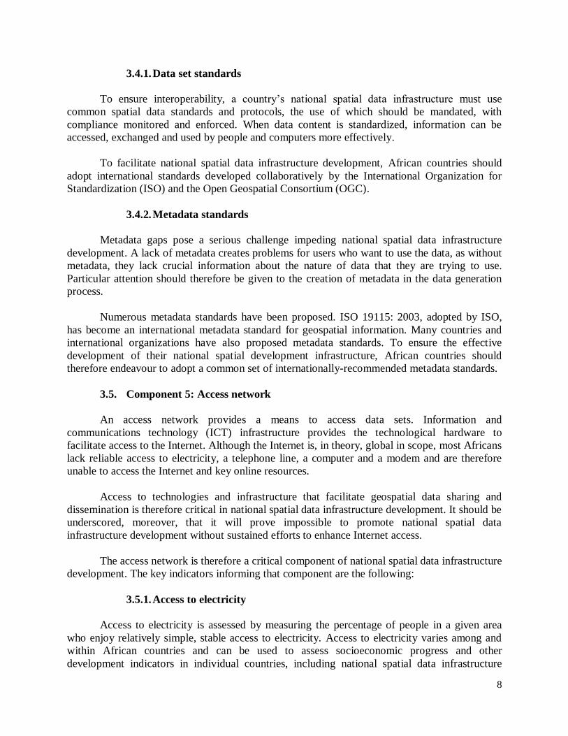
6.3. Component 3: Fundamental data sets......................................................................... 19
6.4. Component 4: Standards............................................................................................ 19
6.5. Component 5: Access network .................................................................................. 21
6.6. Component 6: People ................................................................................................ 22
6.7. Overall results of the assessment ............................................................................... 23
7. Conclusion ......................................................................................................................... 25
Annex: Questionnaire developed to assess the current status of national spatial
data infrastructure development in African countries ................................................................ 26

iii
Executive summary
The present report reviews the status of national spatial data infrastructure development
in African countries and assesses the extent to which national spatial data infrastructure
components are able to meet national geospatial data needs.
Five infrastructure components were assessed, together with an additional strategic
management component. Those components were the following:
1. Strategic plan
2. Policy and legal frameworks
3. Fundamental data
4. Standards
5. Access network
6. People
Twenty key indicators were selected in order to assess the level of maturity of each
component in each country. The six components and the corresponding 20 indicators were as
follows.
1. Component 1: Strategic plan
Indicators:
1. Shared vision
2. Clearly articulated mission statement
3. Specific, measurable, achievable, realistic and time-bound (SMART) objectives
2. Component 2: Policy and legal frameworks
Indicators:
1. National spatial data infrastructure proclamation or directive
2. Lead organization
3. Data policy
4. Funding
3. Component 3: Fundamental data sets
Indicators:
1. Official list of fundamental data sets
2. Availability of digital fundamental data sets
3. Metadata generation

iv
4. Component 4: Standards
Indicators:
1. Data set standards
2. Metadata standards
5. Component 5: Access network
Indicators:
1. Access to electricity
2. Information and Communications Technology Development Index
3. Internet penetration
4. Establishment of a geoportal
6. Component 6: People
Indicators
1. Awareness of geospatial information and national spatial data infrastructure
2. Geospatial information knowledge and skills
3. Capacity and capability development
4. Partnerships
A questionnaire was developed on the basis of the components and indicators identified
above to enable primary data collection from Economic Commission for Africa (ECA) member
States and facilitate a meaningful assessment of national spatial data infrastructure in African
countries. In all, 16 of the 54 ECA member States responded to the questionnaire (approximately
30 per cent of ECA members), and an assessment was conducted on the basis of the responses
received.
The assessment used the methodology developed as part of the Capability Maturity
Model to measure each indicator in the countries that responded to the questionnaire. The
maturity of each component and its respective indicators were categorized as follows:
Level 1: Initial/immature
Level 2: Basic/underdeveloped
Level 3: Defined
Level 4: Managed
Level 5: Optimized
The assessment revealed that only 4 out of the 16 countries scored a weighted average of
more than 50 per cent (and were therefore categorized between levels 2 and 3). South Africa was
awarded the highest score (64 per cent) and was categorized as level 3. On average the 16
countries scored a weighted average of 33.3 per cent, and were categorized between levels 1 and
2.

1. Introduction
To conduct an objective assessment of national spatial data infrastructure development in
African countries, it is essential to gather primary data that accurately reflect the current state of
the aforementioned components and their related indicators. To facilitate data collection, a
questionnaire was developed and sent to geospatial information focal organizations in all 54
ECA member States. An assessment was then carried out on the basis of the responses received
The assessment methodology adopted was based on the Capability Maturity Model,
which was originally developed by the Software Engineering Institute at Carnegie Mellon
University in the United States of America for evaluating and improving software development
processes.
The assessment revealed that national spatial data infrastructure in almost all the
countries that responded to the questionnaire is still at an immature or basic level of
development.

2
2. Brief overview of the approaches recommended for national spatial data
infrastructure development in African countries
2.1. Mandatory national spatial data infrastructure development model
Globally, two models are recommended for national spatial data infrastructure
development. The first is the mandatory model, in accordance with which spatial data
infrastructure is developed pursuant to formal mandates. The mandatory model is usually
supported by relevant legislation, regulations or some other type of government decree or
directive that requires geospatial information providers to make their data sets discoverable and
accessible via national spatial data infrastructure mechanisms.
The second model is the voluntary model, in accordance with which spatial data
infrastructure development is based on existing spatial data coordination activities.
For developing countries, in particular those in Africa, an appropriate policy framework
that facilitates access to geospatial data is a prerequisite for the success of any national spatial
data infrastructure initiative. In addition, intellectual property rights, copyrights, ownership,
liability and other relevant legal issues should be clearly defined. The mandatory model is thus
the more appropriate model for African countries to adopt.
2.2. Product-based national spatial data infrastructure approach
Two alternative approaches for national spatial data infrastructure development were
identified by Rajabifard, Feeny and Williamson in 2002, namely:
1. The process-based approach;
2. The product-based approach.1
The process-based approach focuses on enhancing communication channels with a view
to linking spatial information providers and users. In other words, the objective behind the
process-based approach is to provide better communication channels that help communities
share and use geospatial data assets.
The process-based approach is preferable when geospatial information products and
services are well developed, as is the case in developed economies. African countries’ national
spatial data infrastructure components, on the other hand, are still at a rudimentary level of
development, and the process-based approach is therefore inappropriate.
The product-based approach, however, adapted from that following in developed
countries, ensures that all five infrastructure components are given due consideration with a view
to facilitating the development and roll-out of countries’ spatial data architecture. The product-
1 Abbas Rajabifard, Mary-Ellen Feeny and Ian Williamson, “Future directions for SDI development”, International Journal of Applied Earth Observation and Geoinformation, vol. 4, No. 1 (August 2002), pp. 11-22.

3
based approach is therefore more appropriate in African countries. Figure I illustrates the
relationship among the five product-based national spatial data infrastructure components.
Figure I
Product-based national spatial data infrastructure components
Source: A. Rajabifard (2002).
To date, spatial data infrastructure development in Africa has been impeded by the
adoption by many African countries of the process-based approach, without due consideration
being given to the maturity of those countries’ national spatial data infrastructure. To address
that challenge, a product-based approach that takes into account the particular circumstances of
individual African countries should be adopted.
2.3. Adoption of an analyse-formulate-implement methodology
To facilitate national spatial data infrastructure development, African countries should
adopt the following three-step strategic management methodology:
(a) Analyse the environment;
(b) Formulate a strategy;
(c) Implement that strategy.
Dynamic
People Data
Policy and legal
frameworks
Standards
Access networks

4
3. Key indicators used in the assessment of national spatial data
infrastructure development in African countries
As briefly discussed above, 6 components and 20 indicators were identified and
examined in the assessment. The six components and their corresponding indicators are briefly
described below.
3.1. Component 1: Strategic plan
A strategic plan or road map is an instrument that facilitates the formulation of a medium-
to long-term vision that describes where we want to take an organization, and how we plan to get
there. An often-quoted strategic management adage states: “if you don't know where you're
going, how will you know when you've got there?” A strategic plan is therefore an essential
prerequisite for spatial data infrastructure development in African countries.
The strategic plan should be based on a thorough analysis of the external and internal
environment relevant to the country in question, and should take into account strengths,
weaknesses; opportunities and threats (SWOT) within that country’s geospatial information
environment. The following three key indicators should be articulated in any comprehensive
strategic plan:
3.1.1. Shared vision
A vision is generally defined as an organization’s desired future state if its components
strive diligently to attain the goals and objectives set out in the strategic plan. That vision should
provide guidance and energy for the journey ahead. Such a vision should be discussed and
communicated widely, so that it becomes a vision shared by all relevant stakeholders.
A shared vision should therefore be adopted to inspire, motivate and align the activities of
individuals striving to promote a country’s national spatial data infrastructure development.
3.1.2. Clearly articulated mission statement
A mission statement is a short statement explaining why an organization exists. It helps
organizations articulate their goals, products or services, and identifies its principal customers.
In the context of national spatial data infrastructure initiatives, mission statements sets
forth those initiatives’ long-term objectives and provide guidance to all stakeholders involved in
the process to achieve them.
3.1.3. Specific, measurable, achievable, realistic and time-bound (SMART)
objectives
All effective organizations formulate high-level, qualitative statements that describe the
objectives that must be accomplished in order to achieve their broader goals. In order to be
effective, those objectives must be specific, measurable, achievable, realistic and time-bound

5
(SMART). The formulation of SMART objectives is therefore a key indicator that can be used to
assess national spatial data infrastructure development in African countries.
3.2. Component 2: Policy and legal frameworks
Policy is a critical component of national spatial data infrastructure development and
particular attention should therefore be given to effective policy formulation. This is particularly
relevant in African countries, as adoption of the recommended mandatory model requires the
establishment of rules and regulations that can facilitate the development of national spatial data
infrastructure.
Policies should be developed at the national level to ensure consistency and commonality.
The key national spatial data infrastructure indicators that inform the policy and legal
frameworks component are the following:
3.2.1. National spatial data infrastructure proclamation/directive
National spatial data infrastructure must meet the needs of a wide range of geospatial data
producers and users across government, non-governmental organizations, academia, the private
sector and the general public. A clear proclamation or directive on national spatial data
infrastructure is therefore necessary in order to establish general rules that can guide the
establishment and maintenance of that infrastructure at the national level.
That proclamation or directive can be enacted through one or a combination of the
following instruments:
(a) Act of parliament at the legislative level;
(b) Council of Ministers regulation at the executive level;
(c) Executive Order by Head of State or government;
(d) Ministerial executive order or directive.
3.2.2. Lead organization
Distributed geospatial information management systems serve, primarily, the needs of the
entities owning that information, and little consideration is given to the needs of other potential
users. This can lead to the duplication of efforts and the inefficient use of financial and human
resources. One of the core objectives of national spatial data infrastructure development is to
avoid that duplication of efforts.
All African countries must therefore appoint a lead organization to facilitate and lead
their national spatial data infrastructure development efforts. Accordingly, the appointment of a
lead organization is identified as a key indicator that can inform the policies and legal
frameworks component.
The promotion of national spatial data infrastructure development in African countries
requires the appointment of a lead organization comprising the following entities, which must all
be entrusted with appropriate powers:

6
(a) High-level or ministerial champion;
(b) National spatial data infrastructure executive council;
(c) National spatial data infrastructure secretariat;
(d) Working groups.
3.2.3. Data policy
Data sharing in African countries is a major challenge. Policies should therefore be
developed at a national level to foster consistency and commonality so as to:
(a) Encourage collected data to be used multiple times (data sharing);
(b) Ensure data interoperability (common standards);
(c) Ensure that metadata is a mandatory accompaniment to any data collected
(data accessibility).
In the context of national spatial data infrastructure development, the adoption of a spatial
data policy provides a legal framework that articulates basic principles specific to geospatial
data. That framework should be used by individuals and institutions when generating, collecting,
transforming, disseminating, preserving, and making use of geospatial data.
A spatial data policy should address the following:
(a) Data creation and sharing;
(b) Data ownership and custodianship;
(c) Data security;
(d) Copyright and intellectual property rights;
(e) Pricing.
3.2.4. Funding
National spatial data infrastructure development requires substantial financial resources,
particularly during its early stages. Regular and predictable funding is also essential in the
operation and maintenance phase to ensure the sustainability of countries’ national spatial data
architecture. Clearly-specified funding policies can, inter alia, facilitate efforts to price geospatial
data appropriately, and identify sources of funding to support national spatial data infrastructure
development efforts.
3.3. Component 3: Fundamental data sets
Accurate and authoritative fundamental data are an essential component of national
spatial data infrastructure development. The metadata that accompany geospatial data sets are
also critically important. The availability of fundamental geospatial data sets and their
accompanying metadata are therefore critical indicators that can help guide efforts by African
countries’ to develop their spatial data infrastructure.

7
3.3.1. Official list of fundamental data sets
Fundamental data sets are the minimum primary sets of data that cannot be derived from
other data sets and are required to spatially represent phenomena, objects or themes important for
the realization of sustainable development consistently at the national, regional or global level.
To facilitate the collection, updating and management of fundamental data, it is essential
to determine and agree upon the minimum list of fundamental data sets. Hence the determination
of fundamental data sets is a key indicator informing the fundamental data sets component.
3.3.2. Availability of digital fundamental data sets
Following the determination of its fundamental data sets, each African country must
determine which fundamental data sets are available in that country and how the missing data
can be provided. The available data sets should be reviewed for completeness/scope,
quality/accuracy, and currency/maintenance.
The advantages stemming from the digitization of geospatial data sets include:
(a) Facilitated data storage;
(b) Facilitated data dissemination;
(c) Facilitated data exchange and sharing;
(d) More rapid data updates and corrections;
(e) The possibility of seamlessly integrating data from multiple sources;
(f) The customization of products and services.
3.3.3. Metadata generation
Metadata are data about data. They include such details as the geographical extent of
certain data, the quality of those data, the currency of those data and the provider of those data.
Those details are described in a metadata framework and enhance the use of geospatial
information by enabling relevant data users to make more appropriate decisions.
3.4. Component 4: Standards
Standards provide consistent specifications for the creation, reproduction, updating,
maintaining and sharing of geospatial information, including specifications on how data should
be structured to represent geographic features and how the data are to be exchanged among
information systems. Standards facilitate geospatial information interoperability across systems
and users.
A key objective of national spatial data infrastructure development is to facilitate
geospatial data sharing. The specification and adoption of a compatible suite of standards is a
critical step that must be taken to achieve that objective. The following indicators inform the
standards component:
8
3.4.1. Data set standards
To ensure interoperability, a country’s national spatial data infrastructure must use
common spatial data standards and protocols, the use of which should be mandated, with
compliance monitored and enforced. When data content is standardized, information can be
accessed, exchanged and used by people and computers more effectively.
To facilitate national spatial data infrastructure development, African countries should
adopt international standards developed collaboratively by the International Organization for
Standardization (ISO) and the Open Geospatial Consortium (OGC).
3.4.2. Metadata standards
Metadata gaps pose a serious challenge impeding national spatial data infrastructure
development. A lack of metadata creates problems for users who want to use the data, as without
metadata, they lack crucial information about the nature of data that they are trying to use.
Particular attention should therefore be given to the creation of metadata in the data generation
process.
Numerous metadata standards have been proposed. ISO 19115: 2003, adopted by ISO,
has become an international metadata standard for geospatial information. Many countries and
international organizations have also proposed metadata standards. To ensure the effective
development of their national spatial development infrastructure, African countries should
therefore endeavour to adopt a common set of internationally-recommended metadata standards.
3.5. Component 5: Access network
An access network provides a means to access data sets. Information and
communications technology (ICT) infrastructure provides the technological hardware to
facilitate access to the Internet. Although the Internet is, in theory, global in scope, most Africans
lack reliable access to electricity, a telephone line, a computer and a modem and are therefore
unable to access the Internet and key online resources.
Access to technologies and infrastructure that facilitate geospatial data sharing and
dissemination is therefore critical in national spatial data infrastructure development. It should be
underscored, moreover, that it will prove impossible to promote national spatial data
infrastructure development without sustained efforts to enhance Internet access.
The access network is therefore a critical component of national spatial data infrastructure
development. The key indicators informing that component are the following:
3.5.1. Access to electricity
Access to electricity is assessed by measuring the percentage of people in a given area
who enjoy relatively simple, stable access to electricity. Access to electricity varies among and
within African countries and can be used to assess socioeconomic progress and other
development indicators in individual countries, including national spatial data infrastructure

9
development.
Without access to electricity, there can be no functional ICT and, by extension, no
reliable access to the Internet. Access to electricity is therefore a key indicator that can be used to
inform the access networks component.
3.5.2. Information and Communications Technology Development Index
The ICT Development Index is a composite index that is used to monitor and compare
ICT developments within countries over time. As ICT facilitates access to countries’ geoportals
via the Internet, it is a key indicator informing the access networks component.
The main objectives of the Index are to measure:
(a) The level and evolution over time of ICT developments within countries and the
experience of those countries relative to others;
(b) Progress in ICT development;
(c) The digital divide, i.e. differences among countries in terms of their levels of ICT
development;
(d) The development potential of ICT and the extent to which countries can make use
of that technology to enhance growth and development in light of capacity and skills constraints.
3.5.3. Internet penetration
Internet penetration refers to the portion of the population that enjoys access to the
Internet. As the Internet is the highway for data dissemination, it is a key indicator informing the
access network component.
3.5.4. Establishment of a geoportal
A geoportal is a type of web portal used to locate and access geospatial information via
the Internet. Geospatial information providers, including government agencies, private sources,
non-governmental organizations and academic institutions, use geoportals, inter alia, to publish
descriptions (metadata) of their geospatial information, while professional or casual consumers
of geospatial information use geoportals to search for and access the information they need.
Geoportals play an increasingly important role in the sharing of geospatial information and can
help relevant stakeholders avoid duplicated efforts, inconsistencies, delays, confusion, and the
inefficient use of resources.
3.6. Component 6: People
The people or human capital component is the most important of the five national spatial
data infrastructure components for many developing countries, and particularly for African
countries, many of which still have only limited capacity to generate or use geospatial data.
This component comprises geospatial data producers and users, and any intermediary

10
value-adding agents, who must all interact to move forward the development of countries’
national spatial data architecture. This implies that priority should be given to developing and
strengthening the knowledge and skills that organizations and citizens need in order to produce,
maintain, utilize, and share geospatial information for strategic and day-to-day decision-making.
The key indicators informing this component are the following:
3.6.1. Awareness of geospatial information/national spatial data infrastructure
A lack of awareness among government officials, non-governmental organizations,
private sector stakeholders and the general public regarding the important role played by
geospatial information in sustainable development means that little or no use is made of
geospatial information systems. To raise awareness of geospatial information and national spatial
data infrastructure, efforts must be made to highlight their potential benefits, and obtain support
for and promote investment in national spatial data infrastructure.
The degree to which those stakeholders are aware of the nature and importance of
geospatial information and national spatial data infrastructure is therefore a key indicator
informing the people component.
3.6.2. Geospatial information knowledge and skills
The design and management of appropriate national spatial data infrastructure is crucial if
organizations are to make effective use of geospatial information. The development process must
incorporate organizational aspects of national spatial data infrastructure development and
operationalization. Appropriately trained staff are needed to manage all national spatial data
infrastructure components effectively.
An assessment of national spatial data infrastructure requires an in-depth understanding
of the skills and expertise available in the country concerned, and of how much outside
assistance will be required to move the national spatial data development process forward.
3.6.3. Capacity and capability development
National spatial data infrastructure development in African countries is often dependent
on a small number of critical staff with the technical and managerial skills that are needed in the
production, analysis and management of geospatial information. A lack of suitably qualified
personnel continues to undermine the development of African countries’ spatial data
architecture.
The availability of, and access to, capacity-building institutions that provide degree level
courses and/or diploma/certificate level courses to address the shortage of skilled and
knowledgeable geospatial professionals is therefore a key indicator.
3.6.4. Partnerships

11
All national spatial data infrastructure components depend on partnerships or on the
cooperation among the individuals involved in a country’s data infrastructure development
process. The relationships thus forged facilitate the establishment of infrastructure that
encourages the sharing of geospatial information and the development and maintenance of
standard data sets.
3.7. Summary of the components and their corresponding indicators
An overview of the six components and their corresponding indicators is provided in
table 2. The weighting assigned to each component is also indicated in the table. A standard
weighting of 5 per cent was assigned to each of the 20 indicators.
Table 1
National spatial data infrastructure components and their respective indicators
National spatial data
infrastructure
component
Assigned weighting
(%)
Indicators
1. Strategic plan 15 Shared vision
Clearly articulated mission statement
SMART objectives
2. Policy and legal
frameworks
20 National spatial data infrastructure
proclamation/directive
Lead organization
Data policy
Funding
3. Fundamental data
sets
15 Official list of fundamental data sets
Availability of digital fundamental
data sets
Metadata generation
4. Standards 10 Data set standards
Metadata standards
5. Access network 20 Access to electricity
ICT Development Index
Internet penetration
Establishment of a geoportal
6. People 20 Awareness of geospatial
information/national spatial data
infrastructure
Geospatial information knowledge
and skills
Capacity and capability development
Partnerships

12
4. Assessment data
To conduct a sound comparative assessment in any area of study, it is essential to have
access to reliable, timely and comparable data. An assessment of the current status of national
spatial data infrastructure development in Africa countries therefore depends on the availability
of reliable, timely and comparable data on each of the 54 African States.
A questionnaire on national spatial data infrastructure development was therefore
developed. Considerable effort was made to ensure that the questionnaire covered all aspects of
national spatial data infrastructure development in African countries.
4.1. Questionnaire
The questionnaire was divided into six sections, each covering one of the six components
identified in this report. Those sections are briefly discussed below:
4.1.1. Component 1: Strategic plan
Five questions were formulated in order to assess the maturity of the strategic plan
component and its three corresponding indicators (shared vision; clearly articulated mission
statement; SMART objectives).
4.1.2. Component 2: Policy and legal frameworks
Ten questions were formulated in order to assess the maturity of the policy and legal
frameworks component and its four corresponding indicators (national spatial data infrastructure
proclamation/directive; lead organization; data policy; funding).
4.1.3. Component 3: Fundamental data sets
Thirteen questions were formulated in order to assess the maturity of the fundamental
data sets component and its three corresponding indicators (official list of fundamental data sets;
availability of digital fundamental data sets; metadata generation).
4.1.4. Component 4: Standards
Four questions were formulated in order to assess the maturity of the standards
component and its two corresponding indicators (data set standards; metadata standards).
4.1.5. Component 5: Access network
Five questions were formulated in order to assess the maturity of the access network
component and its four corresponding indicators (access to electricity; ICT Development Index;
Internet penetration; establishment of a geoportal).

13
4.1.6. Component 6: People
Six questions were formulated in order to assess the maturity of the people component
and its four corresponding indicators (awareness of geospatial information/national spatial data
infrastructure; geospatial information knowledge and skills; capacity and capability
development; partnerships).
In summary, a total of 41 questions were asked in order to assess the maturity of the 6
components and the 20 indicators. The questionnaire is attached as Annex I to this report.
4.2. Responses to the questionnaire
The questionnaire was sent to geospatial information focal organizations in all 54 ECA
member States. Only 16 countries (approximately 30 per cent of ECA member States) completed
and returned the questionnaire. The countries that responded and their respective subregions are
indicated in Table 2.
Table 2
Countries that responded to the questionnaire
ECA subregion Country North Africa -
West Africa 1. Burkina Faso
2. Ghana
3. Niger
4. Senegal
5. Togo
Central Africa 6. Cameroon
East Africa 7. Comoros
8. Ethiopia
9. Madagascar
10. South Sudan
11. Uganda
Southern Africa 12. Lesotho
13. Malawi
14. Mozambique
15. Namibia
16. South Africa
As illustrated in Table 2, no responses were received from the North Africa subregion.
Responses were, however, received from all other ECA subregions.
The responses were then analysed in order to assess the current status of the national
spatial data infrastructure development in the responding countries. The responses received from
the 16 countries are set out in Part Two of this report.

14
5. Assessment methodology
The assessment methodology adopted in this study was the based on the Capability
Maturity Model, as adapted by Lamprou and others in 20182 with a view to assessing the
geomaturity of a country’s national spatial data infrastructure. The assessment methodology used
is illustrated in figure II.
Figure II
Assessment methodology used in the study
Source: Based on Lamprou and others, 2018.
The Capability Maturity Model was originally developed by the Software Engineering
Institute at Carnegie Mellon University in the United States of America for evaluating and
improving software development processes. The goal of the model is to develop a methodical
framework for creating high quality software that allows for measurable and repeatable results.
The five levels of the Capability Maturity Model are:
1. Initial; 2. Basic;
3. Defined;
4. Managed;
5. Optimizing.
Those five levels were adopted with a view to assessing the status of national spatial data
infrastructure development in African countries as follows:
1. Initial/Immature: Components of the national spatial data infrastructure
development are generally characterized as ad hoc and immature. While some
components may be well defined, there is only limited awareness of geospatial
information and national spatial data infrastructure at the national level.
2 Alkiviadis Lamprou and others, “Drawing on best practice to assess the geomaturity of a country’s NSDI using a recent example of the work undertaken in Greece”, paper presented at the World Bank annual conference on land and poverty, held in Washington DC, 19-23 March 2018. Available at https://www.oicrf.org/-/drawing-on-best-practice-to-assess-the-geomaturity-of-a-country-s-nsdi-using-the-recent-example-of-the-work-undertaken-greece.
Level 5
Optimizing
Level 4
Managed
Level 3
Defined
Level 1
Initial
Level 2
Basic
Level 1 - Immature
or ad hoc
Not coordinated or
repeatable
Level 2 –
Underdeveloped Follow a previous success but non -
documented
methodology
Level 3 –
Formalized Processes
documented to guide consistent
performance
Level 4 – Managed Documented
processes measured
and analysed
Level 5 –
Optimizing
Defined and managed processes refined by continual
improvement
activities

15
2. Basic/Underdeveloped: Certain national spatial data infrastructure components,
such as fundamental data sets and standards, are at an early stage of development in
the country. There is some semblance of national capacity and capability for data
creation and management, including data sharing, mainly under the auspices of the
national mapping authority or the national geospatial information agency.
3. Defined: National spatial data infrastructure components are at an advanced stage of
development. There is a recognized lead organization spearheading efforts to
promote national spatial data infrastructure development within the country. Well-
articulated efforts are made to communicate with relevant stakeholders and raise
their awareness of the benefits of developing national spatial data capacity.
4. Managed: Policy and legal frameworks for the establishment of national spatial
data infrastructure, enacted, for example, by means of legislation by parliament or a
Council of Ministers regulation, are formally adopted in the country. A strategic
plan for the development of national spatial data infrastructure is developed and an
organization is entrusted with a legal mandate to oversee and guide the country’s
spatial data infrastructure development.
5. Optimizing: Ongoing efforts are made nationally to improve all spatial data
infrastructure components in the country. Those efforts are adequately funded to
ensure the sustainability and optimal use of spatial data.

16
6. Results of the assessment
The status of spatial data infrastructure development in the 16 African countries that
responded to the questionnaire was assessed. First, and as depicted in figure III, each of the 20
indicators was assigned a score of between 1 and 5, in accordance with the Capability Maturity
Model.
Figure III
The Capability Maturity Model-based scores
Level 1 Level 2 Level 3 Level 4 Level 5
Immature Basic Defined Managed Optimizing
The maturity level of the six components was then assessed by calculating the average of
the scores awarded for their respective indicators. The weighted average of the scores awarded
for the six components was in turn computed in order to give an overall score for national spatial
data infrastructure development in the country.
Despite the qualitative nature of the indicators, efforts were made to evaluate the status of
each indicator objectively and on the basis of the data provided in countries’ responses to the
questionnaire.
The assessment of the six components in the 16 countries is summarized below.
6.1. Component 1: Strategic plan
Six of the 16 countries that responded to the questionnaire, namely Ethiopia, Ghana,
Malawi, Namibia, Senegal and Togo, stated that they had already adopted a strategic plan.
Ethiopia, Ghana, Malawi, Namibia and Senegal stated that they had developed a
comprehensive strategic plan. However, even though Togo responded that it had developed a
strategic plan, it did not indicate if that plan articulated the vision, mission and objectives of its
national spatial data infrastructure programme. On the other hand, South Africa indicated that,
although it had not yet fully developed a strategic plan, it had conducted an external
environmental analysis, covering political, economic, social, technological, legal and
environmental issues. Burkina Faso indicated that, although it had drafted a strategic plan, that
plan was still pending adoption.
The other nine countries stated that they had not yet formulated a strategic plan or that
their strategic plans were in the early stages of development.
The assessment of the strategic plan component is summarized in table 3.

17
Table 3
Outcome of the assessment of the strategic plan component
6.2. Component 2: Policy and legal frameworks
Five out of the 16 countries that responded to the questionnaire, namely Malawi,
Namibia, Senegal, South Africa and Togo, stated that they had adopted national spatial data
infrastructure policies or directives. This is illustrated in table 4.
Table 4
Respondent countries that had adopted national spatial data infrastructure policy
instruments.
Country Type of policy instrument
Act of
parliament
Council of Ministers
regulation
Presidenti
al Decree
Ministerial
Decree
Policy
Directives
Malawi Yes - - - -
Namibia Yes - - - -
Senegal - - Yes - -
South Africa Yes Yes Yes - Yes
Togo - - - Yes -
ECA
subregion
Country Outcome of the assessment of the strategic plan
component
Level 1 Level 2 Level 3 Level 4 Level 5
North
Africa
-
West
Africa
1. Burkina Faso
2. Ghana
3. Niger
4. Senegal
5. Togo
Central
Africa
6. Cameroon
East
Africa
7. Comoros
8. Ethiopia
9. Madagascar
10. South Sudan
11. Uganda
Southern
Africa
12. Lesotho
13. Malawi
14. Mozambique
15. Namibia
16. South Africa

18
As illustrated in table 4 above, among the five countries that had adopted policy
instruments, South Africa had enacted a comprehensive set of policies and legal frameworks,
including an act of parliament, a Council of Ministers regulation, a presidential directive and a
series of policy directives.
The other 11 countries had not yet adopted national spatial data infrastructure policies. Of
those 11 countries, however, seven had established lead organizations to oversee their national
spatial data infrastructure initiatives and those organizations had drafted, or were in the process
of drafting, their national policies.
The assessment of the policy and legal framework component is summarized in table 5.
Table 5
Outcome of the assessment of the policy and legal framework component
ECA
subregion
Country Outcome of the assessment of the policy and legal framework
component
Level 1 Level 2 Level 3 Level 4 Level 5
North
Africa
-
West Africa 1. Burkina Faso
2. Ghana
3. Niger
4. Senegal
5. Togo
Central
Africa
6. Cameroon
East Africa 7. Comoros
8. Ethiopia
9. Madagascar
10. South Sudan
11. Uganda
South
Africa
12. Lesotho
13. Malawi
14. Mozambique
15. Namibia
16. South Africa
19
6.3. Component 3: Fundamental data sets
Eleven out of the 16 countries that responded to the questionnaire confirmed that they had
formulated an official list of fundamental data sets. The other five countries, namely the
Comoros, Madagascar, Mozambique, the Niger and Uganda stated that they had not yet drawn
up an approved list.
All 16 countries indicated that certain fundamental data sets were available in digital
form, even though, in most cases, the data contained in those data sets was out of date.
Four countries, namely Malawi, Namibia, Senegal and South Africa, stated that their
fundamental data sets included relevant metadata.
The assessment of the fundamental data sets component is summarized in table 6.
Table 6
Outcome of the assessment of the fundamental data sets component
6.4. Component 4: Standards
Ten out of the 16 countries that responded to the questionnaire stated that they had
established a national body to oversee the formulation and/or adoption of geospatial standards.
The other six countries, namely the Comoros, Lesotho, Madagascar, Mozambique, the Niger and
Senegal, indicated that they had not yet established a national body to oversee that process.
ECA
subregion
Country Outcome of the assessment of the fundamental data sets
component
Level 1 Level 2 Level 3 Level 4 Level 5
North
Africa
-
West
Africa
1. Burkina Faso
2. Ghana
3. Niger
4. Senegal
5. Togo
Central
Africa
6. Cameroon
East
Africa
7. Comoros
8. Ethiopia
9. Madagascar
10. South Sudan
11. Uganda
Southern
Africa
12. Lesotho
13. Malawi
14. Mozambique
15. Namibia
16. South Africa

20
All countries, with the exception of the Comoros, Madagascar, Mozambique, and the
Niger indicated that, in general, they had adopted standards developed by ISO and OGC.
The assessment of the standards component is summarized in table 7.

21
Table 7
Outcome of the assessment of the standards component
6.5. Component 5: Access network
Establishing an access network is a serious challenge for most African countries, as the
proportion of people who enjoy reliable electricity, ICT Development Index scores and Internet
penetration rates in African countries are far lower than global averages, thereby exacerbating
the geospatial digital divide.
The highest-ranked country among the 16 countries that responded to the questionnaire
was South Africa, which reported an access to electricity rate of 84.4 per cent (the world average
stands at 88.9 per cent), an ICT Development Index score of 4.96 (the world average is 5.11) and
an Internet penetration rate of 56.2 per cent (the world average currently stands at 57.3 per cent).
The other 15 countries had much lower scores for those indicators.
Only 7 of the 16 countries, namely Burkina Faso, Ethiopia, Ghana, Malawi, Namibia,
Senegal, and South Africa, stated that they had established geoportals.
The assessment of the access network component is summarized in table 8.
ECA
subregion
Country Outcome of the assessment of the standards component
Level 1 Level 2 Level 3 Level 4 Level 5
North
Africa
-
West
Africa
1. Burkina Faso
2. Ghana
3. Niger
4. Senegal
5. Togo
Central
Africa
6. Cameroon
East
Africa
7. Comoros
8. Ethiopia
9. Madagascar
10. South Sudan
11. Uganda
Southern
Africa
12. Lesotho
13. Malawi
14. Mozambique
15. Namibia
16. South Africa

22
Table 8
Outcome of the assessment of the access network component
6.6. Component 6: People
The four indicators that inform the people component, namely awareness of geospatial
information/national spatial data infrastructure, geospatial information knowledge and skills,
capacity and capability development, and partnerships, were viewed as significant challenges by
all 16 countries that responded to the questionnaire. In most of those countries, geospatial
awareness levels remain low, while in-country geospatial knowledge and skills, and capacity and
capability development were all judged to be weak.
The assessment of the people component is summarized in table 9.
ECA
subregion
Country Outcome of the assessment of the access network component
Level 1 Level 2 Level 3 Level 4 Level 5
North
Africa
-
West
Africa
1. Burkina Faso
2. Ghana
3. Niger
4. Senegal
5. Togo
Central
Africa
6. Cameroon
East
Africa
7. Comoros
8. Ethiopia
9. Madagascar
10. South Sudan
11. Uganda
Southern
Africa
12. Lesotho
13. Malawi
14. Mozambique
15. Namibia
16. South Africa

23
Table 9
Outcome of the assessment of the people component
6.7. Overall results of the assessment
The overall results of the assessment are presented in table 10 below, which illustrates
that only 4 out of the 16 countries that responded to the questionnaire scored a weighted average
of more than 50 per cent. The highest score was achieved by South Africa, which scored 64 per
cent. The other three countries that scored a weighted average of more than 50 per cent were
Malawi, with a score of 52 per cent, Namibia, which scored 56 per cent, and Senegal, which
scored 52 per cent.
ECA
subregion
Country Outcome of the assessment of the people component
Level 1 Level 2 Level 3 Level 4 Level 5
North
Africa
-
West
Africa
1. Burkina Faso
2. Ghana
3. Niger
4. Senegal
5. Togo
Central
Africa
6. Cameroon
East
Africa
7. Comoros
8. Ethiopia
9. Madagascar
10. South Sudan
11. Uganda
Southern
Africa
12. Lesotho
13. Malawi
14. Mozambique
15. Namibia
16. South Africa

24
Table 10
Overall results of the assessment of national spatial data infrastructure development ECA
subregion
Country National spatial data infrastructure components: weighted scores
Strategic
plan
(15%)
Policy
and
legal
frame
works
(20%)
Fundam
ental
data sets
(15%)
Standard
s (10%)
Access
network
(20%)
People
(20%)
Total
(100%)
North Africa -
West Africa 1. Burkina Faso 3 4 6 4 8 8 33 2. Ghana 9 4 6 4 8 8 39
3. Niger 3 4 3 2 4 4 20
4. Senegal 9 12 9 2 12 8 52
5. Togo 6 8 8 4 4 4 34
Central
Africa
6. Cameroon 3 4 6 4 4 4 25
East Africa 7. Comoros 3 4 3 2 4 4 20
8. Ethiopia 9 4 6 4 8 4 35
9. Madagascar 3 4 3 2 4 4 20
10. South Sudan 3 4 3 2 4 4 20
11. Uganda 3 4 4 4 4 4 23
Southern
Africa
12. Lesotho 3 4 3 2 4 4 20
13. Malawi 9 12 9 6 8 8 52
14. Mozambique 3 4 3 2 4 4 20
15. Namibia 9 12 9 6 12 8 56
16. South Africa 6 16 12 6 12 12 64
Average scores for the 16 countries
5.25
6.5
5.81
3.5
6.5
5.75
33.31

25
7. Conclusion
The assessment, which was based on the Capability Maturity Model, used primary data
obtained from 16 ECA member States.
The failure of African countries to develop robust national spatial data infrastructure has
often been simplistically attributed to capacity and capability gaps, which affect many
developing countries and are particularly grave in many countries in Africa. The assessment
reveals, however, that the problem is much more complex and multifaceted, and that many
challenges stem from the methodologies used by most African countries to promote national
spatial data infrastructure development, which are often the same methodologies used by
developed countries in North America, Europe and Australasia.
It is well known that the six components analysed in the assessment are well developed in
developed countries, which were the first countries to promote national spatial data infrastructure
development. Furthermore, there is sufficient awareness in developed countries at all levels of
government and within the private sector of the importance of geospatial information in
sustainable development. As all components supporting the national spatial data infrastructure
development process were already well developed in all advanced economies, the methodologies
adopted by those economies in the area of spatial data infrastructure development tended to
centre on a process-based approach.
In developing countries, however, in particular those in Africa, none of the six
components are particularly well developed. There is also a serious lack of awareness of the
important role that geospatial information plays in sustainable development, particularly at senior
policy decision-making levels of government.
The challenges that stem from the failure of many African countries to adopt a strategic
plan on spatial data infrastructure development is compounded by the failure of many of those
countries to adopt robust policy and legal frameworks, inadequate human resources, weak access
networks and a lack of timely, accurate, and standard-compliant fundamental data.
26
Annex
Questionnaire developed to assess the current status of
national spatial data infrastructure development in African
countries

27
Questionnaire for the assessment of NSDI implementation
in African countries
This questionnaire aims to assess the status of national spatial data infrastructure (NSDI)
implementation in African countries. The questionnaire is based on identified key indicators that
can be used to assess countries’ readiness in developing and implementing NSDI.
The responses to this questionnaire will be compiled to identify existing national
strategies aligned with NSDI, and to conduct a review of the current status of NSDI in the
countries. The results will be used to develop a summary report on the assessment results.
The questionnaire has been developed by the consultant engaged by ECA with an overall
objective of preparing a guideline document on implementation of NSDI in African countries.
The guideline document will further discuss and assess the challenges and achievements of
NSDI implementation in African countries and experiences and best practices in other parts of
the world.
The questionnaire is divided into six components: Strategic planning; Policy and legal
frameworks; Data; Standards; Access Networks; and People. The questions are posed in
order to gain a comprehensive picture of the status of national spatial data infrastructure (NSDI)
in your country. Please note that the information provided will be treated in confidence and only
aggregated results will be made public.
ECA is kindly requesting you to complete the questionnaire carefully, to the best of your
knowledge, and to return it by 16 August 2019 to: Andre Nonguierma ([email protected]) or
Aster Denekew ([email protected]) and copied to Sultan Mohammed (sultan.mohammeda
@yahoo.com).
We thank you in advance for your cooperation and assistance in fulfilling this important
task on behalf of ECA.
Details of respondent
Name: ______________________________________________________
Position title: ________________________________________________
Name of organization: _________________________________________
Country: ____________________________________________________
Email: ______________________________________________________
Telephone number: ____________________________________________
Fax number: _________________________________________________

28
1. Component 1: Strategic plan
1.1. Does your country have a strategic plan for the development and implementation of
national spatial data infrastructure (NSDI)?
Yes
No
If the answer to Question 1.1 is “Yes”,
1.2. Please indicate which of the following topics are addressed in the NSDI strategic plan:
Environmental (external and internal) analysis
SWOT analysis
Vision
Mission
Goals
Objectives
Others (please specify):
________________________________________________________________________
________________________________________________________________________
_______________________________________________________________
1.3. Which of the following have been considered as Government priorities in the preparation
of the NSDI strategic plan for your country?
Land administration
Climate change/environmental protection
Population and housing census
Medium-/long-term national development plan
African Union Agenda 2063: The Africa We Want
United Nations Sustainable Development Goals (SDGs)
Others (please specify):
________________________________________________________________________
________________________________________________________________________
_______________________________________________________________
1.4. Which of the following have been identified as strategic issues (challenges) in NSDI
implementation in your country?
Lack of NSDI directive/policy regarding data creation, data sharing, data security,
copyright, intellectual property rights (IPRs), etc.)
Unavailability of updated fundamental digital data sets
Lack of standards
Inadequate access network (ICT infrastructure, geoportal, clearing house, etc.)
Lack of skilled manpower
Lack of geospatial information/NSDI awareness
Lack of funding

29
Others (please specify):
________________________________________________________________________
________________________________________________________________________
_______________________________________________________________
1.5. If the answer to Question 1.1 is “No”, do you plan to prepare a NSDI strategic plan and
when?
1.6.
Yes
In the next 12 months
In the next two to three years
No Please provide reasons for not having a plan for the preparation of a NSDI
strategic plan:
________________________________________________________________________
________________________________________________________________________
_______________________________________________________________
2. Component 2: Policy and legal frameworks
2.1. Does your country have a national spatial data infrastructure (NSDI) policy/directive?
Yes
No
2.2. If the answer to Question 2.1 is “Yes”, please select the instrument(s) that is/are used and
indicate the year of enactment:
Type Year of enactment
Act of parliament
Council of Ministers regulation
Executive order/directive by Head of State
(President/Prime Minister)
Ministerial executive order/directive
Other (please specify):__________________
2.3. Which of the following policy issues related to geospatial data are addressed in the NSDI
policy/directive?
Spatial data creation
Spatial data sharing
Spatial data security
Spatial data ownership/custodianship
Copyright
Intellectual property rights (IPRs)
Spatial data pricing

30
Others (please specify):
_______________________________________________________________________
2.4. How are NSDI policies linked/related to other geospatial information-related national
policies, such as policies on e-Government, national information and communication
infrastructure, or a national strategy for the development of statistics?
Coordination mechanism
Standardization
Interoperability
Common geographies
Data sharing
Other (please specify): ____________________________
2.5. What is the status of NSDI policy implementation?
Fully implemented (Since - year _____________)
Partially implemented
Not implemented
2.6. If the policy is only partially implemented, or not implemented, what are the main
reasons?
2.7.
Lack of capacity (knowledge and skills)
Lack of funding
Others (please specify):
________________________________________________________________________
________________________________________________________________________
_______________________________________________________________
2.8. Does your country have a legally-mandated NSDI lead organization (coordinator)?
Yes
No
2.9. If the answer to Question 2.7 is “Yes”, which organization is assigned with this
responsibility?
National mapping (geospatial information) agency or equivalent
National space/remote sensing agency or equivalent
National statistics agency or equivalent
National cadastre agency or equivalent
Other (please specify): __________________________

31
2.10. How are your NSDI activities funded?
Budget allocated by national government
Foreign government/donor
Non-governmental organization (NGO)
Private sector
Other (please specify): ____________________________
2.11. If the answer to Question 2.1 is “No”, has any effort been made in the past to enact a
NSDI policy in your country?
Yes (please specify how):
…………………………………………………………………………………………........
...................................................................................................................................
No (please specify why):
………………………………………………………………………………………………
……………………………………………………………………………………
3. Component 3: Fundamental data sets
3.1. Does your country have an officially declared list of fundamental geospatial data sets?
Yes
No
3.2. If the answer to Question 3.1 is “Yes”, which of the following does the fundamental
geospatial data set list include?
Geodetic control network
Elevation/depth (DSM/DTM)
Topography (national base map)
Ortho-imagery (aerial photographs and/or satellite images)
Geographic names
Addresses
Administrative boundaries (functional areas)
Buildings/settlements
Transport networks
Land parcels (cadastre)
Population distribution
Land cover/land use
Geology/soils
Water bodies
Others (please specify): __________________________

32
3.3. Based on the official list of fundamental geospatial data sets, please identify the authorized
fundamental geospatial data sets that are available in your country?
Data description Format
(digital/analogue)
Scale/resolution Metadata
available
(yes/no)
Coverage
(percentage
of country)
Geodetic control
network
Elevation/ depth
(DSM/DTM)
Topography
(national base
map)
Ortho-imagery
Geographic
names
Addresses
Administrative
boundaries
(functional
areas)
Buildings/settle
ments
Transport
networks
Land parcels
(cadastre)
Population
distribution
Land cover/land
use
Geology/soils
Water bodies
3.4. What is the average age of the fundamental geospatial data sets available?
Less than 5 years
5–10 years
10–15 years
>15 years
3.5. Which types of the following software are used for the production, maintenance, and
dissemination of fundamental geospatial data sets in your country?
Proprietary (please specify): _________________________
Open source (please specify): _________________________

33
A combination of proprietary and open source
Other (please specify): ________________________
3.6. If the answer to Question 3.1 is “No”, does your country plan to prepare an official list of
fundamental geospatial data sets, and, if so, when?
Yes
In the next 12 months
In the next two to three years
No Please provide reasons for not having a plan for the preparation of an official
list of fundamental geospatial data sets:
________________________________________________________________________
________________________________________________________________________
_______________________________________________________________
3.7. Do you have continuous operating reference stations in your country?
Yes
No
If the answer to Question 3.7 is “Yes”,
3.8. Please provide the number of continuous operating reference stations in your country:
_________________
3.9. How many of the continuous operating reference stations are recognized international
Global Navigation Satellite System Service (IGS) sites? ____________
3.10. How many of the continuous operating reference stations in your country have been
established by your national geodetic agency/national mapping agency for the purpose of
defining and maintaining national geodetic reference frames? _______________
3.11. Which of the following communications systems are used for data transmission between a
continuous operating reference station site and a network control centre?
ADSL (Asymmetric digital subscriber line)
Mobile phone network
WAN (wide area network) between sites
VSAT (Very small aperture terminal) satellite link
Other (please specify): ______________________
3.12. Who provided the funds for the establishment of continuous operating reference stations in
your country?
National government budget;
Foreign government assistance (bilateral development partner) (please specify):
_________________________

34
Multilateral development assistance (please specify): _____________________
Non-governmental organization (NGO) assistance (please specify):
_____________________________
Other (please specify): ______________________
3.13. If the answer to Question 3.7 is “No”, does your country plan to establish continuous
operating reference stations and when?
Yes
In the next 12 months
In the next two to three years
No Please provide reasons for not having a plan for the establishment of an
official list of fundamental geospatial data sets:
____________________________________________________________
4. Component 4: Standards
4.1. Does your country have a national standards body that oversees the creation and/or
adoption of geospatial (data and metadata) standards?
Yes
No
4.2. If the answer to Question 4.1 is “Yes”, which one of the following is the responsible
standards body?
National standards authority
National mapping/geospatial information agency
National space/remote sensing agency
National ICT agency
Other (please specify): _______________________________________
4.3. Which of the following standards are actively used for the acquisition, maintenance and
dissemination of fundamental geospatial data sets in your country?
Standards developed by the International Organization for Standardization (ISO)
Standards developed by the Open Geospatial Consortium (OGC)
Standards developed by the International Hydrographic Organization (IHO)
Standards adopted from donor countries (please specify): _________
Standards adopted from NGOs (please specify): _________________
Standards adopted from software suppliers (please specify): ________
Nationally developed standards
4.4. Which geodetic reference system is in use in your country?
Local datum
WGS 84

35
ITRF
Other (please specify): _____________________________
5. Component 5: Access networks
5.1. Does the NSDI lead organization in your country have geospatial portal services?
Yes
No
If the answer to question 5.1 is “Yes”,
5.2. How was your country’s geospatial portal developed?
Using in-house capacity/resources
With the support of external development partners (please specify):
______________________________________
5.3. Which of the following software types has been used to develop your country’s
geoportal?
Proprietary (please specify): _______________________
Open source (please specify): ______________________
Other (please specify): ___________________________
5.4. Which of the following geospatial portal services are provided?
Data upload
Data download
Search and discovery
Query
View
Metadata
5.5. Does your country’s ICT infrastructure (hardware, software, telecommunication
infrastructure, etc.) satisfy your country’s NSDI operational requirements?
Yes
No

36
6. Component 6: People
6.1. How do you rate the available numbers (quantity) of the following categories of
geospatial information professionals adequate to develop and implement NSDI in your
country?
Category Number of available manpower
High Medium Low
Managers
Technical experts
(university degree
level)
Technicians
(diploma/certificate
level)
6.2. How do you rate the knowledge and skills (quality) of the available geospatial
information professionals in your country?
Category Level of knowledge and skills
High Medium Low
Managers
Technical experts
(university degree
level)
Technicians
(diploma/certificate
level)
6.3. What are the national geospatial information capacity-building mechanisms in your
country?
In-house training by the national mapping/geospatial information agency; NSDI
secretariat
In-country institutes of higher learning (universities)
In-country technical and/or vocational training schools
External/foreign institutes of higher learning (universities)
In-country technical workshops
External/foreign technical workshops
Others (please specify):
________________________________________________________________________
______________________________________________________
6.4. How are geospatial information capacity-building efforts in your country funded?
National Government budget

37
Donors (bilateral and/or multilateral) (please provide examples): ______________
Non-governmental organizations (NGOs) (please provide examples):
________________________________________
Private (please provide examples): _______________________________________
Others (please provide examples): ________________________________________
6.5. How do you rate the level of geospatial information awareness in your country?
Category Level of awareness
High Medium Low
High-level policy
decision makers
Other government
officials
Private sector
Citizens
6.6. The Government in my country does not consider NSDI a priority. Please tick the box
that best matches this statement.
Strongly agree
Agree
Disagree
Strongly disagree
Not sure
Additional comments:
………………………………………………………………………………………………………
………………………………………………………………………………………………………
………………………………………………………………………………………………………
………...........
Thank you for completing this questionnaire.
Economic Commission for Africa


![Spatial Data Infrastructure (SDI) “[Spatial Data Infrastructure] provides a basis for spatial data discovery, evaluation, and application for users and](https://img.pdfslide.us/doc/110x75/56649d5f5503460f94a3f713/spatial-data-infrastructure-sdi-spatial-data-infrastructure-provides.jpg)