Embed Size (px)
Citation preview
Cultana Solar Farm:
Native Vegetation Clearance Report
Cultana Solar Farm: Native Vegetation Clearance Report 15 January 2019
Version 3
Prepared by EBS Ecology for SIMEC ZEN Energy
Document Control
Revision No. Date issued Authors Reviewed by Date Reviewed Revision type
1 11/12/2018 M Laws, G. Oerman Dr M. Louter 11/12/2018 Draft
2 21/12/2018 M. Laws Final
3 15/01/2019 M. Laws Final
Distribution of Copies
Revision No. Date issued Media Issued to
1 11/12/2018 Electronic Rex Pong, SIMEC Zen Energy
2 21/12/2018 Electronic Rex Pong, SIMEC Zen Energy
3 15/01/2019 Electronic Rex Pong, SIMEC Zen Energy
EBS Ecology Project Number: E80308
COPYRIGHT: Use or copying of this document in whole or in part (including photographs) without the written
permission of EBS Ecology’s client and EBS Ecology constitutes an infringement of copyright.
LIMITATION: This report has been prepared on behalf of and for the exclusive use of EBS Ecology’s client, and is
subject to and issued in connection with the provisions of the agreement between EBS Ecology and its client. EBS
Ecology accepts no liability or responsibility whatsoever for or in respect of any use of or reliance upon this report by
any third party.
CITATION: EBS Ecology (2019) Cultana Solar Farm: Native Vegetation Clearance Report. Report to SIMEC ZEN
Energy. EBS Ecology, Adelaide.
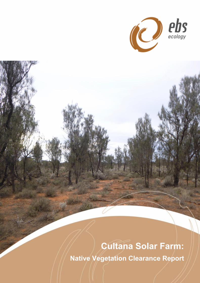
Cover photograph: Casuarina pauper / Acacia papyrocarpa / Myoporum platycarpum Low Forest over Atriplex
vesicaria / Maireana sedifolia +/- Maireana pyramidata
EBS Ecology
125 Hayward Avenue
Torrensville, South Australia 5031
t: 08 7127 5607
http://www.ebsecology.com.au
email: [email protected]
Cultana Solar Farm: Native Vegetation Clearance Report
ii
GLOSSARY AND ABBREVIATION OF TERMS
ALA Atlas of Living Australia
BAM Bushland Assessment Method
BDBSA Biological Database of South Australia (maintained by DEW)
DEW Department of Environment and Water
DotE Department of the Environment
DotEE Department of the Environment and Energy
EBS EBS Ecology
EPBC Act Environment Protection and Biodiversity Conservation Act 1999
Golder Golder Associates Pty Ltd
GPS Global Positioning System
GWh Gigawatt hours
ha Hectare/s
IBRA Interim Biogeographical Regionalisation of Australia
kV Kilovolt
MW Megawatt
NatureMaps Initiative of DEW that provides a common access point to maps and geographic
information about South Australia's natural resources in an interactive online
mapping format
EP NRM Eyre Peninsula Natural Resources Management region
NPW Act National Parks and Wildlife Act 1972
NRM Natural Resources Management
NVAP Native Vegetation Assessment Panel
NV Act Native Vegetation Act 1991
NVB Native Vegetation Branch
NVC Native Vegetation Council
NVMU Native Vegetation Management Unit
Project Development of the Cultana Solar Farm
Project area The land containing the proposed Cultana Solar Farm and associated
infrastructure, which is located approximately 5 km north of Whyalla, South
Australia
SA South Australia/South Australian
SEB Significant Environmental Benefit (under the Native Vegetation Act 1991)

Cultana Solar Farm: Native Vegetation Clearance Report
iii
sp. Species
spp. Species (plural)
ssp. Subspecies
RAM Rangelands Assessment Method
TEC Threatened Ecological Community
UIA Unincorporated Area
Cultana Solar Farm: Native Vegetation Clearance Report
iv
EXECUTIVE SUMMARY
EBS Ecology was engaged by SIMEC ZEN Energy to conduct an ecological assessment within the
proposed area for the development of the Cultana Solar Farm, which is located approximately 5 km north
of Whyalla, South Australia.
The ecological assessment consisted of a desktop, vegetation and fauna assessment, with key objectives
of the being to:
1. Determine the potential impacts of the proposed development on flora and fauna species,
particularly those threatened at the national and state level; and
2. Calculate the Significant Environment Benefit (SEB) offset for the Project, which is required
for approval to clear native vegetation under Division 5 of the Native Vegetation Regulations
2017.
Desktop assessment
A desktop assessment was completed to identify species of state and national conservation significance
potentially occurring in the Project area and inform field survey requirements. The key results of desktop
assessment include:
Whilst Saltmarsh communities occur within the Project area, they are not considered to qualify as
the Threatened Ecological Community, Subtropical and Temperate Coastal Saltmarsh, as the
Project area falls outside the area of tidal influence (due to the Whyalla Saltworks);
All nationally threatened flora species identified in the database searches were considered unlikely
to occur within the Project area;
One nationally threatened fauna species; the Western Grasswren (Gawler Ranges) (Amytornis
textilis myall), was considered to potentially occur within the Project area;
Two migratory fauna species; the Fork-tailed Swift (Apus pacificus) and Osprey (Pandion
haliaetus), have potential to occur within the Project area;
No State threatened ecosystems were recorded during the vegetation assessment;
The state vulnerable Sandalwood (Santalum spicatum) was identified to have potential to occur
within the Project area prior to the field assessment. However, Sandalwood was not observed
during the vegetation assessment and was subsequently downgraded to unlikely to occur; and
Four state threatened fauna species could occur in the Project area:
o Two State threatened species may possibly occur within the Project area, the White-
bellied Sea Eagle (Haliaeetus leucogaster) and Osprey (Pandion haliaetus); and
o Two State threatened species are considered likely to occur in the Project area, the
Western Slender-billed Thornbill (Acanthiza iredalei iredalei) and the Elegant Parrot
(Neophema elegans).
Cultana Solar Farm: Native Vegetation Clearance Report
v
Vegetation assessment
The key results of the vegetation assessment include:
A total of eight vegetation associations were mapped and assessed within Block A (northern
property);
A total of five vegetation associations were mapped and assessed within Block B (southern
property);
The species inventory from the vegetation assessment identified 42 native flora species and four
weed species;
Weeds were widespread over the Project area. Ward’s Weed (Carrichtera annua), was
widespread within Block A and Block B, while Common Iceplant (Mesembryanthemum
crystallinum) was also common within Block B. Onion Weed (Asphodelus fistulosus) was abundant
along the water pipeline within Block A and Block B;
Two Weeds of National Significance listed under the EPBC Act were observed within the Project
area, with few individuals of African Boxthorn (Lycium ferocissimum) present within Block B and
isolated individuals of Prickly Pear (Opuntia stricta) present within Block A. Both WoNS are also
declared under the NRM Act. The only other declared weed species observed over the Project
area was Horehound (Marrubium vulgare), located as a group of few individuals in Block B; and
With the Project area being assessed using the Rangelands Assessment Method, the total SEB
points required for the vegetation clearance is 64,919.34, which equates to an SEB offset of
8,114.92 ha. Alternatively, the total payment into the Native Vegetation Fund required is
$5,586,207.13, which includes the total administration fee of $291,224.09; and
With the Project area being assessed using the Bushland Assessment Method, the total SEB
points required for the vegetation clearance is 69,836.51, which equates to an SEB offset of
8,729.56 ha.
Fauna assessment
The key results of the vegetation assessment include:
A total of 384 birds from 39 species were recorded during point counts and opportunistically within
the Project area;
One introduced bird species; the Common Starling (Sturnus vulgaris) was observed within the
Project area;
There were no Western Grasswrens observed in the Project area nor areas of their preferred
habitat, due to the absence of minor drainage lines, which supported large spiny shrubs (>0.75 m)
in high densities. However, there was 43.19 ha of potential habitat identified, where Blackbush
(Maireana pyramidata) shrubs were dense and frequently greater than 50 cm in height;
Six Red Kangaroos (Macropus rufus) and four Western Grey Kangaroos (Macropus fuliginosus)
observed;

Cultana Solar Farm: Native Vegetation Clearance Report
vi
The introduced Fox (Vulpes vulpes) and Rabbit (Oryctolagus cuniculus) were observed. A
potentially active fox den and an in-active rabbit warren were also observed within the Project
area;
Five species of reptile were observed: the Crested Dragon (Ctenophorus cristatus); Spotted
Ctenotus (Ctenotus orientalis); Yellow-faced Whipsnake (Demansia psammophis); Central
Bearded Dragon (Pogona vitticeps); and Sleepy Lizard (Tiliqua rugosa); and
No species of state of national significance recorded within the Project area.
Cultana Solar Farm: Native Vegetation Clearance Report
vii
Table of Contents
1 APPLICATION INFORMATION ............................................................................... 1
2 BACKGROUND ....................................................................................................... 2
2.1 Purpose of the proposal ............................................................................................................ 2
2.2 Objectives .................................................................................................................................. 2
2.3 Project area ............................................................................................................................... 2
2.4 Land history ............................................................................................................................... 2
2.5 Interim Biographical Regionalisation of Australia (IBRA) .......................................................... 4
2.6 Administrative Boundaries ......................................................................................................... 5
2.7 Climate ....................................................................................................................................... 5
2.8 Legislative requirements ............................................................................................................ 6
2.8.1 Native Vegetation Act 1991 .......................................................................................... 6
2.8.2 Environment Protection and Biodiversity Conservation Act 1999 (Commonwealth) .... 6
2.8.3 National Parks and Wildlife Act 1972 ........................................................................... 7
2.8.4 Natural Resources Management Act 2004 ................................................................... 7
2.8.5 Past clearance approvals ............................................................................................. 7
3 METHODS ............................................................................................................... 8
3.1 Desktop assessment ................................................................................................................. 8
3.1.1 EPBC Act Protected Matters Search Tool (PMST) ...................................................... 8
3.1.2 Biological Database of South Australia (BDBSA) ......................................................... 8
3.1.3 Likelihood of occurrence assessment .......................................................................... 8
3.1.4 Desktop assessment limitations ................................................................................... 9
3.2 Vegetation assessment ........................................................................................................... 10
3.2.1 Assessment method justification – RAM vs BAM ....................................................... 10
3.2.2 Rangelands Assessment Method (RAM) ................................................................... 10
3.2.3 RAM scoresheets ....................................................................................................... 11
3.2.4 Bushland Assessment Method (BAM) ........................................................................ 11
3.2.5 BAM scoresheets ........................................................................................................ 12
3.2.6 Vegetation assessment limitations ............................................................................. 13
3.3 Fauna assessment .................................................................................................................. 14
3.3.1 Birds ............................................................................................................................ 14
3.3.2 Other fauna ................................................................................................................. 15
3.3.3 Fauna assessment limitations .................................................................................... 15
4 DESKTOP ASSESSMENT OUTCOMES ............................................................... 16
4.1 Matters of National Significance .............................................................................................. 16
4.1.1 Nationally important wetlands ..................................................................................... 16
4.1.2 Commonwealth lands ................................................................................................. 17
4.1.3 Threatened ecological communities ........................................................................... 17
Cultana Solar Farm: Native Vegetation Clearance Report
viii
4.1.4 Nationally threatened flora .......................................................................................... 17
4.1.5 Nationally Threatened fauna ....................................................................................... 17
4.1.6 Migratory fauna ........................................................................................................... 18
4.2 Matters of state significance .................................................................................................... 32
4.2.1 Threatened ecosystems ............................................................................................. 32
4.2.2 Threatened flora ......................................................................................................... 32
4.2.3 Threatened fauna ....................................................................................................... 32
5 VEGETATION ASSESSMENT OUTCOMES ......................................................... 35
5.1.1 Site A1 ........................................................................................................................ 39
5.1.2 Site A2 ........................................................................................................................ 40
5.1.3 Site A3 ........................................................................................................................ 42
5.1.4 Site A4 ........................................................................................................................ 43
5.1.5 Site A5 ........................................................................................................................ 44
5.1.6 Site A6 ........................................................................................................................ 45
5.1.7 Site A7 ........................................................................................................................ 46
5.1.8 Site A8 ........................................................................................................................ 47
5.1.9 Site B1 ........................................................................................................................ 48
5.1.10 Site B2 ........................................................................................................................ 49
5.1.11 Site B3 ........................................................................................................................ 50
5.1.12 Site B4 ........................................................................................................................ 51
5.1.13 Site B5 ........................................................................................................................ 52
6 FAUNA ASSESSMENT OUTCOMES ................................................................... 53
6.1 Birds ......................................................................................................................................... 53
6.2 Mammals ................................................................................................................................. 53
6.3 Reptiles .................................................................................................................................... 53
7 REQUIREMENTS OF THE REGULATION ............................................................ 55
7.1 Regulation under which the clearance is applicable ............................................................... 55
7.2 Risk assessment ...................................................................................................................... 56
7.2.1 Principle (b) It has significance as a habitat for wildlife .............................................. 56
7.2.2 Principle (c) It includes plants of a rare, vulnerable or endangered species .............. 56
7.2.3 Principle (d) The vegetation comprises the whole, or part, of a plant community that is
Rare, Vulnerable or Endangered ................................................................................ 56
8 MITIGATION HIERARCHY .................................................................................... 57
8.1 Borrow pits ............................................................................................................................... 57
8.1.1 Vegetation Impact ....................................................................................................... 57
8.1.2 Justification ................................................................................................................. 57
8.2 Dense Myall Woodlands .......................................................................................................... 57
8.2.1 Vegetation Impact ....................................................................................................... 57
Cultana Solar Farm: Native Vegetation Clearance Report
ix
8.2.2 Justification ................................................................................................................. 57
8.3 Low density trees in chenopod shrubland ............................................................................... 57
8.3.1 Vegetation Impact ....................................................................................................... 57
8.3.2 Justification ................................................................................................................. 58
8.4 General chenopod shrubland .................................................................................................. 58
8.4.1 Vegetation Impact ....................................................................................................... 58
8.4.2 Justification ................................................................................................................. 58
8.5 High voltage overhead powerlines (275kV) ............................................................................. 58
8.5.1 Vegetation Impact ....................................................................................................... 58
8.5.2 Justification ................................................................................................................. 59
8.6 Perimeter access roadways .................................................................................................... 59
8.6.1 Vegetation Impact ....................................................................................................... 59
8.6.2 Justification ................................................................................................................. 59
8.7 East-west access roadways .................................................................................................... 60
8.7.1 Vegetation Impact ....................................................................................................... 60
8.7.2 Justification ................................................................................................................. 60
8.8 North-south accessways ......................................................................................................... 60
8.8.1 North-south accessways (construction) ...................................................................... 60
8.8.2 North-south accessways (pperation) .......................................................................... 61
8.8.3 Justification ................................................................................................................. 62
8.9 Offset ....................................................................................................................................... 62
9 SIGNIFICANT ENVIRONMENTAL BENEFIT (SEB) ............................................. 63
9.1 Determination of the SEB obligation ........................................................................................ 63
9.1.1 RAM ............................................................................................................................ 63
9.1.2 BAM ............................................................................................................................ 63
10 DISCUSSION ......................................................................................................... 66
10.1 Flora assessment .................................................................................................................... 66
10.2 Fauna assessment .................................................................................................................. 66
10.2.1 Nationally threatened species ..................................................................................... 66
10.2.2 Migratory species ........................................................................................................ 67
10.2.3 State threatened species ............................................................................................ 67
11 RECOMMENDATIONS .......................................................................................... 69
11.1 Legislative approvals ............................................................................................................... 69
11.1.1 EPBC Act referral ....................................................................................................... 69
11.1.2 Native vegetation clearance ....................................................................................... 69
11.2 Mitigation hierarchy.................................................................................................................. 69
11.2.1 Avoidance ................................................................................................................... 69
11.2.2 Minimisation ................................................................................................................ 69
11.2.3 Offset .......................................................................................................................... 70
Cultana Solar Farm: Native Vegetation Clearance Report
x
12 REFERENCES ....................................................................................................... 71
13 APPENDICES ........................................................................................................ 73
Appendix 1. Flora species recorded at each of the RAM / BAM sample points within the Project
area. ............................................................................................................................. 73
Appendix 2. Fauna species recorded during the field assessment within the Project area. * =
introduced species. ...................................................................................................... 75
Appendix 3. Fauna species recorded at each of the point count sites over the Project area. .... 77
List of Tables
Table 1. Native vegetation clearance application information for the Cultana Solar Farm
Project. ........................................................................................................................... 1
Table 2. IBRA bioregion, subregion, and environmental association environmental landscape
summary. ........................................................................................................................ 4
Table 3. Factors that influence the value of the three parameters used to calculate the total SEB
area and value in the RAM (NVB 2017). ...................................................................... 11
Table 4. Factors that influence the value of the three parameters used to calculate the total SEB
area and value in the BAM (NVMU 2017). ................................................................... 12
Table 5. Summary of the results of the PMST report (DotEE, 2018). ......................................... 16
Table 6. Threatened flora and fauna, and migratory species potentially occurring within the
Project area. ................................................................................................................. 19
Table 7. Sites stratified by the two Blocks (A and B) of land and vegetation associations, within
the Project area. ........................................................................................................... 36
Table 8. Summary of RAM and BAM scores for Site A1. ............................................................ 39
Table 9. Summary of RAM and BAM scores for Site A2a. .......................................................... 40
Table 10. Summary of RAM and BAM scores for Site A2b. ........................................................ 41
Table 11. Summary of RAM and BAM scores for Site A3. .......................................................... 42
Table 12. Summary of RAM and BAM scores for Site A4. .......................................................... 43
Table 13. Summary of RAM and BAM scores for Site A5. .......................................................... 44
Table 14. Summary of RAM and BAM scores for Site A6. .......................................................... 45
Table 15. Summary of RAM and BAM scores for Site A7. .......................................................... 46
Table 16. Summary of RAM and BAM scores for Site A8. .......................................................... 47
Table 17. Summary of RAM and BAM scores for Site B1. .......................................................... 48
Table 18. Summary of RAM and BAM scores for Site B2. .......................................................... 49
Table 19. Summary of RAM and BAM scores for Site B3. .......................................................... 50
Table 20. Summary of RAM and BAM scores for Site B4. .......................................................... 51
Table 21. Summary of RAM and BAM scores for Site B5. .......................................................... 52
Table 22. Summary of the SEB requirements for the Project based on the RAM and BAM. ..... 63
Table 23. SEB calculations using the RAM. ................................................................................ 64
Table 24. SEB calculations using the BAM. ................................................................................ 65
Cultana Solar Farm: Native Vegetation Clearance Report
xi
Table 25. RAM sites that support suitable habitat for the Western Slender-billed Thornbill
(SBTB) and Elegant Parrot (EP). ................................................................................. 68
List of Figures
Figure 1. Location of the proposed Cultana Solar Farm (Project area) showing Block A (Cultana
North Boundary – in yellow), Block B (Cultana South Boundary – in red) and
associated infrastructure. ............................................................................................... 3
Figure 2. Mean maximum and minimum monthly temperatures and mean monthly rainfall
recorded at Whyalla Aero Station (station no. 018120) from 1945 to 2018. .................. 5
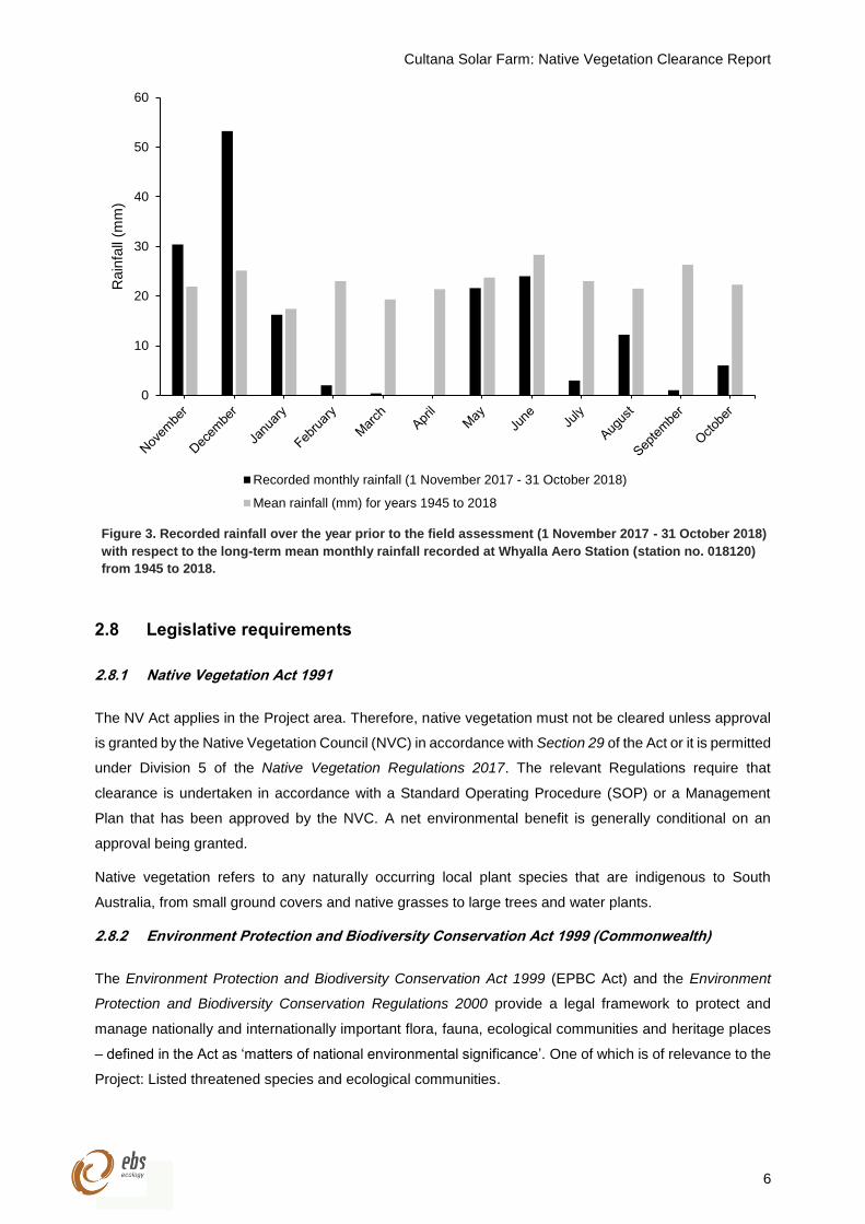
Figure 3. Recorded rainfall over the year prior to the field assessment (1 November 2017 - 31
October 2018) with respect to the long-term mean monthly rainfall recorded at
Whyalla Aero Station (station no. 018120) from 1945 to 2018. ..................................... 6
Figure 4. BDBSA records of national and state threatened flora species within 10 km of the
Project area. ................................................................................................................. 33
Figure 5. BDBSA records of national and state threatened fauna within 10 km of the Project
area. ............................................................................................................................. 34
Figure 6. Vegetation associations (Sites) within Block A of the Project area. ............................. 37
Figure 7. Vegetation associations (Sites) within Block B of the Project area. ............................. 38
Figure 8. Location of suitable habitat within the Project area. No suitable habitat was observed
in Block B. .................................................................................................................... 54
Cultana Solar Farm: Native Vegetation Clearance Report
1
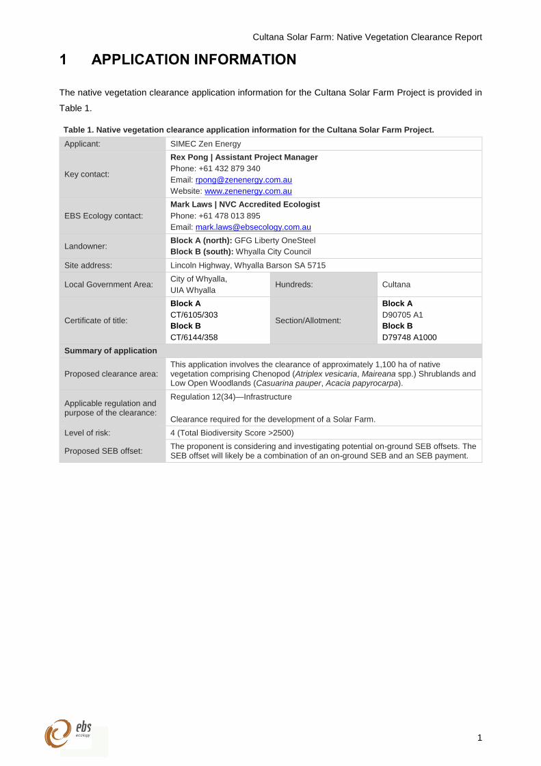
1 APPLICATION INFORMATION
The native vegetation clearance application information for the Cultana Solar Farm Project is provided in
Table 1.
Table 1. Native vegetation clearance application information for the Cultana Solar Farm Project.
Applicant: SIMEC Zen Energy
Key contact:
Rex Pong | Assistant Project Manager
Phone: +61 432 879 340
Email: [email protected]
Website: www.zenenergy.com.au
EBS Ecology contact:
Mark Laws | NVC Accredited Ecologist
Phone: +61 478 013 895
Email: [email protected]
Landowner: Block A (north): GFG Liberty OneSteel
Block B (south): Whyalla City Council
Site address: Lincoln Highway, Whyalla Barson SA 5715
Local Government Area: City of Whyalla,
UIA Whyalla Hundreds: Cultana
Certificate of title:
Block A
CT/6105/303
Block B
CT/6144/358
Section/Allotment:
Block A
D90705 A1
Block B
D79748 A1000
Summary of application
Proposed clearance area: This application involves the clearance of approximately 1,100 ha of native vegetation comprising Chenopod (Atriplex vesicaria, Maireana spp.) Shrublands and Low Open Woodlands (Casuarina pauper, Acacia papyrocarpa).
Applicable regulation and purpose of the clearance:
Regulation 12(34)—Infrastructure
Clearance required for the development of a Solar Farm.
Level of risk: 4 (Total Biodiversity Score >2500)
Proposed SEB offset: The proponent is considering and investigating potential on-ground SEB offsets. The SEB offset will likely be a combination of an on-ground SEB and an SEB payment.
Cultana Solar Farm: Native Vegetation Clearance Report
2
2 BACKGROUND
2.1 Purpose of the proposal
EBS Ecology (EBS) was engaged by SIMEC ZEN Energy to conduct a native vegetation and fauna
assessment within the proposed area for the development of the Cultana Solar Farm (the Project), located
near Whyalla, South Australia.
The Project boasts 600 GWh of energy generation per year, which will be drawn from 780,000 solar panels
with 280 MW capacity. Construction of the Cultana Solar Farm is expected to be initiated in early 2019,
employing approximately 350 workers during construction and providing greater energy security to the
Whyalla Liberty OneSteel steelworks.
2.2 Objectives
The key objectives of the native vegetation and fauna assessments were to:
1. Determine the potential impacts of the proposed development on flora and fauna species,
particularly those threatened at the national and state level; and
2. Calculate the Significant Environment Benefit (SEB) offset for the Project, which is required for
approval to clear native vegetation under Division 5 of the Native Vegetation Regulations 2017.
2.3 Project area
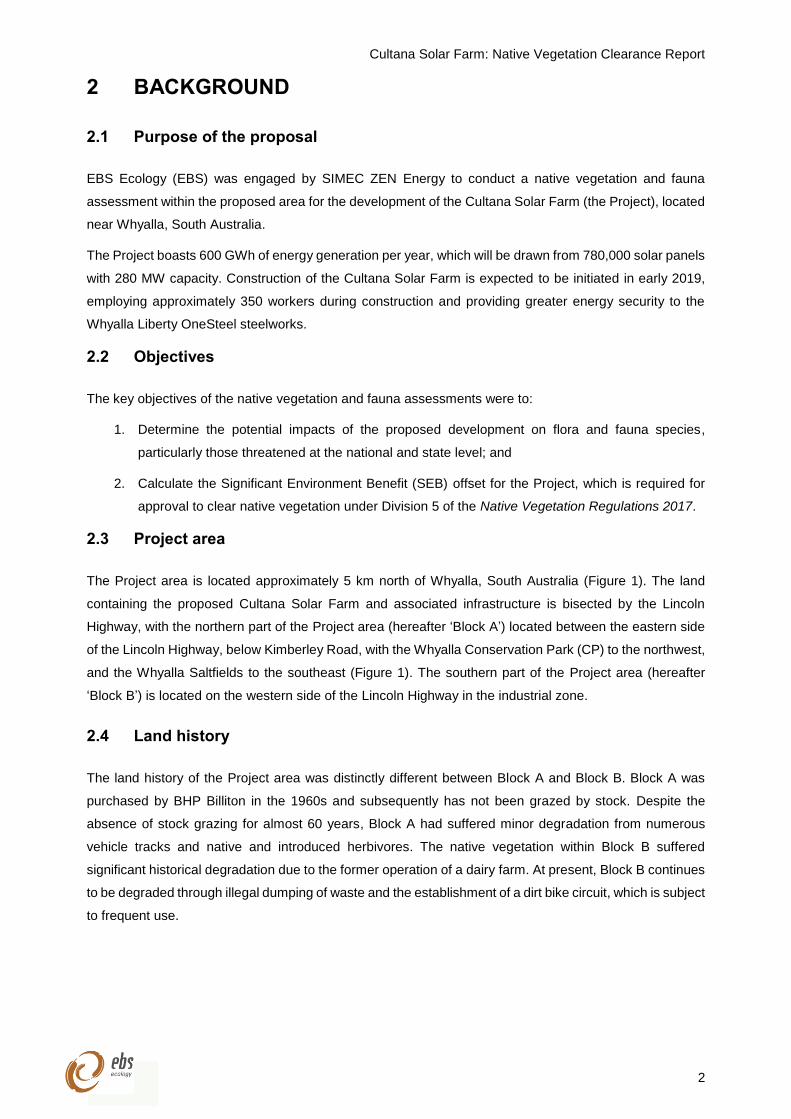
The Project area is located approximately 5 km north of Whyalla, South Australia (Figure 1). The land
containing the proposed Cultana Solar Farm and associated infrastructure is bisected by the Lincoln
Highway, with the northern part of the Project area (hereafter ‘Block A’) located between the eastern side
of the Lincoln Highway, below Kimberley Road, with the Whyalla Conservation Park (CP) to the northwest,
and the Whyalla Saltfields to the southeast (Figure 1). The southern part of the Project area (hereafter
‘Block B’) is located on the western side of the Lincoln Highway in the industrial zone.
2.4 Land history
The land history of the Project area was distinctly different between Block A and Block B. Block A was
purchased by BHP Billiton in the 1960s and subsequently has not been grazed by stock. Despite the
absence of stock grazing for almost 60 years, Block A had suffered minor degradation from numerous
vehicle tracks and native and introduced herbivores. The native vegetation within Block B suffered
significant historical degradation due to the former operation of a dairy farm. At present, Block B continues
to be degraded through illegal dumping of waste and the establishment of a dirt bike circuit, which is subject
to frequent use.
Cultana Solar Farm: Native Vegetation Clearance Report
3
Figure 1. Location of the proposed Cultana Solar Farm (Project area) showing Block A (Cultana North
Boundary – in yellow), Block B (Cultana South Boundary – in red) and associated infrastructure.
Cultana Solar Farm: Native Vegetation Clearance Report
4
2.5 Interim Biographical Regionalisation of Australia (IBRA)
The Interim Biogeographical Regionalisation of Australia (IBRA) identifies geographically distinct
bioregions based on common climate, geology, landform, native vegetation and species information, which
is used to assess and plan for the protection of biodiversity (DotE 2012). The bioregions are further refined
into subregions and environmental associations. Native vegetation remnancy figures for IBRA subregions
and environmental associations are useful for setting regional landscape targets.
The Project area is located within the Gawler IBRA bioregion, the Myall Plains IBRA subregion and the
Tregolana IBRA environmental association (Table 2). Approximately 97% (1,050,684 ha) of the Myall
Plains IBRA subregion is mapped as remnant native vegetation, of which 8% (86,146 ha) is formally
conserved.
Table 2. IBRA bioregion, subregion, and environmental association environmental landscape summary.
Gawler IBRA bioregion
Semi-arid to arid, flat topped to broadly rounded hills of the Gawler Range Volcanics and Proterozoic sediments,
low plateaux on sandstone and quartzite with an undulating surface of Aeolian sand or gibbers and rocky quartzite
hills with colluvial footslopes, erosional and depositional plains and salt encrusted lake beds, with Black Oak
(Casuarina pauper) and Myall (Acacia papyrocarpa) Low Open Woodlands, Open Mallee Scrub, Bluebush
(Maireana spp.) / Saltbush (Atriplex spp.) Open Chenopod Shrublands and Mulga (Acacia aneura) Tall Shrublands
on shallow loams, calcareous earths and hard red duplex soils.
Myall Plains IBRA subregion
Gently undulating calcrete plains and occasional quartzite or granite hills. Includes a zone of salt lakes and gypsum
dunes at Lake Gillies and steep strike ranges at the Middleback Ranges. To the east out cropping conglomerate
occurs with mangrove flats along the coastal margin. Myall / Black Oak Low Woodland is found on grey brown
calcareous earths, red calcareous earths and dense brown loams on the plains. Rocky outcrops support Ridge-
fruited Mallee (Eucalyptus incrassate) / Broom Honey-myrtle (Melaleuca uncinata) Open Scrub and Drooping
Sheoak (Allocasuarina verticillata) Low Woodland on dense brown loams. The lowest areas support of Shrubby
Saltwort (Halosarcia halocnemoides) Shrubland on grey calcareous loams. Light grazing occurs in most areas.
Remnant
vegetation
Approximately 97% (1,050,684 ha) of the subregion is mapped as remnant native vegetation,
of which 8% (86,146 ha) is formally conserved.
Landform Gently undulating calcrete plains and occasional hills. Includes a zone of salt lakes and
gypsum dunes at Lake Gillies and steep strike ranges at the Middleback Ranges.
Geology Calcrete development; gypsum dunes; play lakes with silt and clay deposits and evaporites.
Soil Red calcareous earths, sandy soils with mottled yellow clayey subsoils.
Vegetation Assumed native vegetation cover.
Conservation
significance
59 species of threatened fauna, 40 species of threatened flora.
4 wetlands of national significance.
Tregolana IBRA environmental association
Landscape Erosional plain.
Landform Undulating plain with occasional low sand dunes and pans, some samphire or mangrove flats.
Geology Sand, gravel and alluvium.
Soil Red calcareous earths, reddish sands, crusty red duplex soils and grey calcareous loams.
Vegetation Low woodland of Myall and Black Oak, Saltbush, Bluebush and Samphire Chenopod
Shrublands, low woodland of mangroves.
Cultana Solar Farm: Native Vegetation Clearance Report
5
2.6 Administrative Boundaries
The Project area is located within the Whyalla and UIA Whyalla Local Government Areas (LGA), the
Hundreds of Cultana and the Eyre Peninsula Natural Resource Management (EP NRM) region.
2.7 Climate
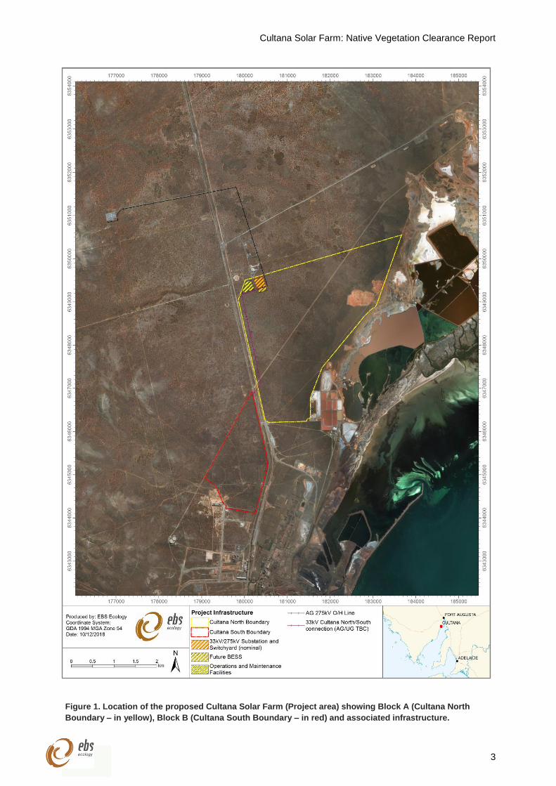
Climate data was sourced from the Whyalla Aero station (station no. 018120), located 6.7 km from the
western boundary of the Project area. Whyalla has a Mediterranean climate characterised by cool winters
and hot summers, with mean maximum temperatures ranging from 17C in July to 30.2C in January. The
wettest months are June (28.3 mm), September (26.3 mm) and December (25.1 mm), and therefore, while
rainfall is greatest in winter, there is low seasonal variability (Figure 2) (Commonwealth of Australia 2018).
A total of 170 mm of rain was recorded in the year prior to the vegetation and fauna assessment, which is
substantially lower than the long-term mean annual rainfall of 267.1 mm (Figure 3). The scarcity of rain
was most pronounced in the nine months prior to the assessment, with 70.2 mm of rain, which was 138.6
mm lower than the mean rainfall from February to October (208.8 mm).
Figure 2. Mean maximum and minimum monthly temperatures and mean monthly rainfall recorded at Whyalla
Aero Station (station no. 018120) from 1945 to 2018.
0
5
10
15
20
25
30
0
5
10
15
20
25
30
35
Rain
fall
(mm
)
Tem
pera
ture
(⁰C
)
Mean monthly rainfall Mean maximum temperature Mean minimum temperature
Cultana Solar Farm: Native Vegetation Clearance Report
6
Figure 3. Recorded rainfall over the year prior to the field assessment (1 November 2017 - 31 October 2018)
with respect to the long-term mean monthly rainfall recorded at Whyalla Aero Station (station no. 018120)
from 1945 to 2018.
2.8 Legislative requirements
2.8.1 Native Vegetation Act 1991
The NV Act applies in the Project area. Therefore, native vegetation must not be cleared unless approval
is granted by the Native Vegetation Council (NVC) in accordance with Section 29 of the Act or it is permitted
under Division 5 of the Native Vegetation Regulations 2017. The relevant Regulations require that
clearance is undertaken in accordance with a Standard Operating Procedure (SOP) or a Management
Plan that has been approved by the NVC. A net environmental benefit is generally conditional on an
approval being granted.
Native vegetation refers to any naturally occurring local plant species that are indigenous to South
Australia, from small ground covers and native grasses to large trees and water plants.
2.8.2 Environment Protection and Biodiversity Conservation Act 1999 (Commonwealth)
The Environment Protection and Biodiversity Conservation Act 1999 (EPBC Act) and the Environment
Protection and Biodiversity Conservation Regulations 2000 provide a legal framework to protect and
manage nationally and internationally important flora, fauna, ecological communities and heritage places
– defined in the Act as ‘matters of national environmental significance’. One of which is of relevance to the
Project: Listed threatened species and ecological communities.
0
10
20
30
40
50
60
Rain
fall
(mm
)
Recorded monthly rainfall (1 November 2017 - 31 October 2018)
Mean rainfall (mm) for years 1945 to 2018
Cultana Solar Farm: Native Vegetation Clearance Report
7
Any action that has, will have, or is likely to have a significant impact on matters of national environmental
significance requires referral under the EPBC Act. Substantial penalties apply for undertaking an action
that has, will have or is likely to have significant impact on a matter of national environmental significance
without approval.
2.8.3 National Parks and Wildlife Act 1972
Native plants and animals in South Australia are protected under the National Parks and Wildlife Act 1972
(NPW Act). It is an offence to take a native plant or protected animal without approval. Threatened plant
and animal species are listed in Schedules 7 (endangered species), 8 (vulnerable species) and 9 (rare
species) of the Act.
Conservation rated flora and fauna species listed on Schedules 7, 8, or 9 of the NPW Act may occur within
the Project area. Persons must comply with the conditions imposed upon permits and approvals.
2.8.4 Natural Resources Management Act 2004
Under the Natural Resources Management Act 2004 (NRM Act) landholders have a legal responsibility to
manage declared pest plants and animals and prevent land and water degradation.
Key components under the Act include the establishment of regional Natural Resource Management
(NRM) Boards and development of regional NRM Plans; the ability to control water use through
prescription, allocations and restrictions; requirement to control pest plants and animals and activities that
might result in land degradation.
A ‘duty of care’ is a fundamental component of this Act, i.e. ensuring one’s environmental and civil
obligation by taking reasonable steps to prevent land and water degradation. Persons can be prosecuted
if they are considered negligent in meeting their obligations.
2.8.5 Past clearance approvals
There are no past clearance approvals relevant to the Project.
Cultana Solar Farm: Native Vegetation Clearance Report
8
3 METHODS
3.1 Desktop assessment
Databases compiled and managed by the Department of the Environment and Energy (DotEE) and
Department of Environment and Water (DEW) (South Australia) were analysed to determine threatened
flora and fauna species known to occur or potentially occur within 10 km of the Project area. The aim of
the desktop assessment was to determine whether any species or threatened ecological communities
listed under the EPBC Act or NPW Act have potential to occur within the Project area.
3.1.1 EPBC Act Protected Matters Search Tool (PMST)
A Protected Matters Report was generated on 04 July 2018 to identify matters of national environmental
significance under the EPBC Act. The online PMST, which is maintained by DotEE, was used to identify
any flora and fauna species or ecological communities of national environmental significance under the
EPBC Act that may occur or may have suitable habitat within the Project area. A 10 km buffer was applied
to the search (DotEE 2018).
3.1.2 Biological Database of South Australia (BDBSA)
A data extraction from the Biological Database of South Australia (BDBSA), which is maintained by DEW,
was obtained to identify flora and fauna species that have been recorded within 10 km of the Project area
(DEW 2018a, accessed 09/07/2018, Record set number DEWNRBDBSA180709-1). The BDBSA is
comprised of an integrated collection of species records from the South Australian (SA) Museum,
conservation organisations, private consultancy companies, Birds SA, Birdlife Australia and the
Australasian Wader Study Group, which meet DEW standards for data quality, integrity and maintenance.
3.1.3 Likelihood of occurrence assessment
An assessment to determine the likelihood of occurrence for threatened species, migratory species and
threatened ecological communities (TECs) within the Project area was conducted. Each of the threatened
species and TECs identified by the PMST and BDBSA were assigned a rating (highly likely, likely, possible
and unlikely), which described their likelihood of occurrence with the Project area. The following criteria
were considered when assigned a likelihood rating:
Presence during the field survey;
Presence of suitable habitat as informed by the field survey;
Date of the most recent record (taking into consideration the date of the last surveys conducted in
the area);
Proximity of the records (i.e. distance to the Project area);
Landscape, vegetation remnancy and vegetation type of the record location (taking into
consideration the landscape, remnancy and vegetation type of the Project area, with higher
likelihood assigned to species that were found in similar locations/condition/vegetation
associations); and
Cultana Solar Farm: Native Vegetation Clearance Report
9
Knowledge of the species habitat preferences, causes of its decline, the conspicuousness of the
species and local population trends.
3.1.4 Desktop assessment limitations
Flora and fauna records were sourced from the BDBSA. The BDBSA only includes verified flora and fauna
records submitted to DEW or partner organisations. It is recognised that knowledge is poorly captured,
and it is possible that significant species occur that are not reflected by database records. Although much
of the BDBSA data has been through a variety of validation processes, the lists may contain errors and
should be used with caution. DEW give no warranty that the data is accurate or fit for any particular purpose
of the user or any person to whom the user discloses the information.
BDBSA flora and fauna records were limited to a 10 km buffer around the Project area. The reliability of
the BDBSA data ranges from 100 m to over 100 km. Fauna species, especially birds, can traverse
distances more than 10 km search buffer, and therefore, additional species may occur. It is also
acknowledged that the presence of species may not be adequately represented by database records.
Hence, the BDBSA results may not highlight all potential threatened flora and fauna species that may occur
in the area, within a 10 km buffer.
The findings and conclusions expressed by EBS Ecology are based solely upon information in existence
at the time of the assessment. The combination of field data, database records and background research
have provided a solid baseline foundation for determining the likelihood of occurrence for threatened
species within the Project area.
Cultana Solar Farm: Native Vegetation Clearance Report
10
3.2 Vegetation assessment
The vegetation assessment was conducted by NVC accredited consultant Mark Laws between 29 October
and 5 November 2018. The assessment was conducted in accordance with the both the Rangelands
Assessment Method (RAM) (NVB 2017) and Bushland Assessment Method (BAM) (NVMU 2017).
Justification for using the RAM in the EP NRM region, and a description of both methods are provided
below.
3.2.1 Assessment method justification – RAM vs BAM
It is noted that using the RAM in agricultural Natural Resources Management (NRM) regions requires
approval from the Native Vegetation Assessment Panel (NVAP). Approval is therefore sought to use the
RAM in the EP NRM region.
The RAM is more suitable in this situation since the land use within and surrounding the Project area is, or
has been, used for grazing rather than agriculture. Furthermore, the vegetation associations and condition
within the Project area are reflective of rangeland associations and it is therefore difficult to assign suitable
benchmark communities when using the BAM.
Should the NVAP not approve the use of the RAM to assess the vegetation within the Project area, a BAM
was also conducted at each sample point and the results are presented within this report.
3.2.2 Rangelands Assessment Method (RAM)
The RAM is suitable for assessing vegetation systems within the South Australian Arid Lands and Alinytjara
Wilurara NRM regions. This method aligns the assessment of vegetation (and land) condition with the
method developed by Natural Resources South Australian Arid Lands for the rapid assessment of pastoral
properties in sheep and cattle country, but is adapted for native vegetation assessments in arid rangelands
throughout South Australia (NVB 2017).
When using the RAM, each area to be assessed (i.e. each application area) is termed a ‘Block’, which is
divided into stratified ‘Sites’. Each Site relates to a vegetation association found within the Block.
Vegetation associations are based on landform types, paddocks and at increasing distances from watering
points (i.e. grazing gradient). In each Site, a number of ‘Sample Points’ are established by the accredited
ecologist undertaking the assessment.
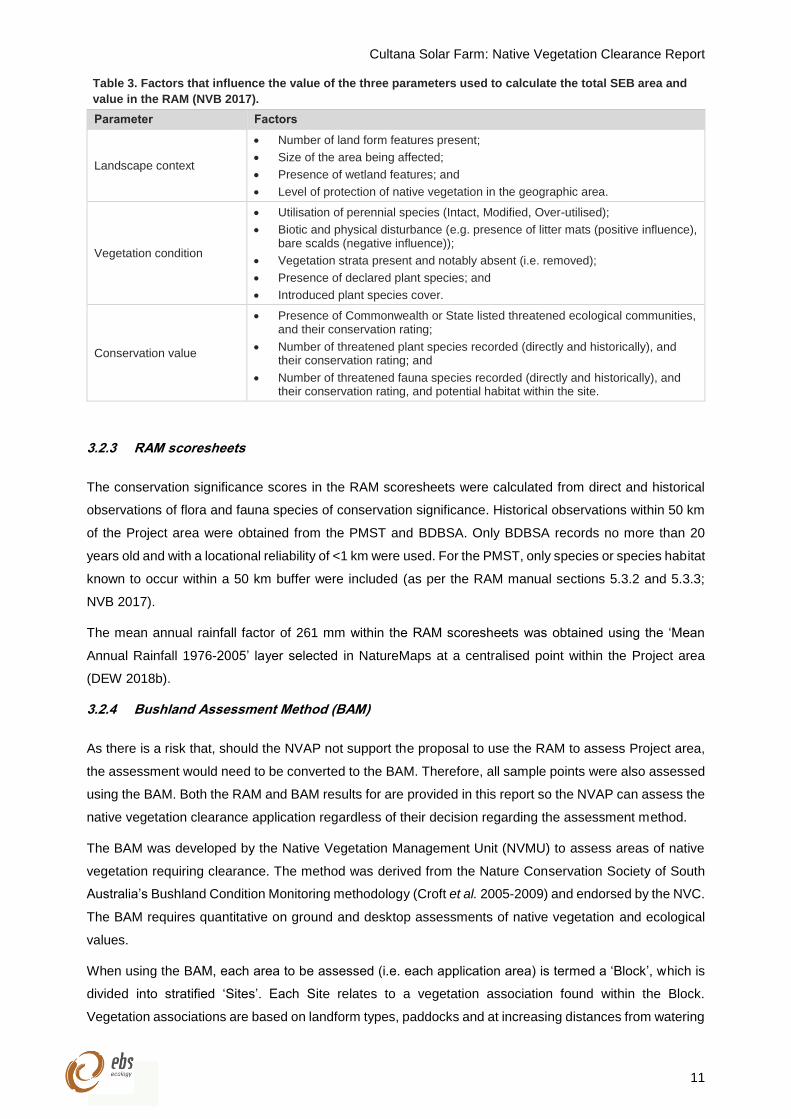
Three components of the biodiversity value of the Site are measured and scored (Table 3):
Landscape context (1.00-1.25);
Vegetation condition (24.00-80.00); and
Conservation value (1.00-1.50).
The three component scores are combined to provide a ‘Unit Biodiversity Score’ (per hectare) and then
multiplied by the size (hectares) of the Site to provide a ‘Total Biodiversity Score’ for each Site, and then
the overall Block.
Cultana Solar Farm: Native Vegetation Clearance Report
11
Table 3. Factors that influence the value of the three parameters used to calculate the total SEB area and
value in the RAM (NVB 2017).
Parameter Factors
Landscape context
Number of land form features present;
Size of the area being affected;
Presence of wetland features; and
Level of protection of native vegetation in the geographic area.
Vegetation condition
Utilisation of perennial species (Intact, Modified, Over-utilised);
Biotic and physical disturbance (e.g. presence of litter mats (positive influence), bare scalds (negative influence));
Vegetation strata present and notably absent (i.e. removed);
Presence of declared plant species; and
Introduced plant species cover.
Conservation value
Presence of Commonwealth or State listed threatened ecological communities, and their conservation rating;
Number of threatened plant species recorded (directly and historically), and their conservation rating; and
Number of threatened fauna species recorded (directly and historically), and their conservation rating, and potential habitat within the site.
3.2.3 RAM scoresheets
The conservation significance scores in the RAM scoresheets were calculated from direct and historical
observations of flora and fauna species of conservation significance. Historical observations within 50 km
of the Project area were obtained from the PMST and BDBSA. Only BDBSA records no more than 20
years old and with a locational reliability of <1 km were used. For the PMST, only species or species habitat
known to occur within a 50 km buffer were included (as per the RAM manual sections 5.3.2 and 5.3.3;
NVB 2017).
The mean annual rainfall factor of 261 mm within the RAM scoresheets was obtained using the ‘Mean
Annual Rainfall 1976-2005’ layer selected in NatureMaps at a centralised point within the Project area
(DEW 2018b).
3.2.4 Bushland Assessment Method (BAM)
As there is a risk that, should the NVAP not support the proposal to use the RAM to assess Project area,
the assessment would need to be converted to the BAM. Therefore, all sample points were also assessed
using the BAM. Both the RAM and BAM results for are provided in this report so the NVAP can assess the
native vegetation clearance application regardless of their decision regarding the assessment method.
The BAM was developed by the Native Vegetation Management Unit (NVMU) to assess areas of native
vegetation requiring clearance. The method was derived from the Nature Conservation Society of South
Australia’s Bushland Condition Monitoring methodology (Croft et al. 2005-2009) and endorsed by the NVC.
The BAM requires quantitative on ground and desktop assessments of native vegetation and ecological
values.
When using the BAM, each area to be assessed (i.e. each application area) is termed a ‘Block’, which is
divided into stratified ‘Sites’. Each Site relates to a vegetation association found within the Block.
Vegetation associations are based on landform types, paddocks and at increasing distances from watering
Cultana Solar Farm: Native Vegetation Clearance Report
12
points (i.e. grazing gradient). In each Site, a number of ‘Sample Points’ are established by the accredited
ecologist undertaking the assessment (NVMU 2017).
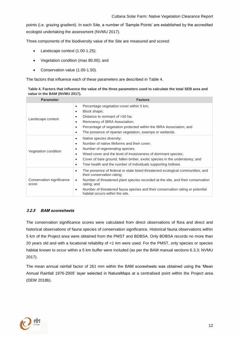
Three components of the biodiversity value of the Site are measured and scored:
Landscape context (1.00-1.25);
Vegetation condition (max 80.00); and
Conservation value (1.00-1.50).
The factors that influence each of these parameters are described in Table 4.
Table 4. Factors that influence the value of the three parameters used to calculate the total SEB area and
value in the BAM (NVMU 2017).
Parameter Factors
Landscape context
Percentage vegetation cover within 5 km;
Block shape;
Distance to remnant of >50 ha;
Remnancy of IBRA Association;
Percentage of vegetation protected within the IBRA Association; and
The presence of riparian vegetation, swamps or wetlands.
Vegetation condition
Native species diversity;
Number of native lifeforms and their cover;
Number of regenerating species;
Weed cover and the level of invasiveness of dominant species;
Cover of bare ground, fallen timber, exotic species in the understorey; and
Tree health and the number of individuals supporting hollows
Conservation significance score
The presence of federal or state listed threatened ecological communities, and their conservation rating;
Number of threatened plant species recorded at the site, and their conservation rating; and
Number of threatened fauna species and their conservation rating or potential habitat occurs within the site.
3.2.5 BAM scoresheets
The conservation significance scores were calculated from direct observations of flora and direct and
historical observations of fauna species of conservation significance. Historical fauna observations within
5 km of the Project area were obtained from the PMST and BDBSA. Only BDBSA records no more than
20 years old and with a locational reliability of <1 km were used. For the PMST, only species or species
habitat known to occur within a 5 km buffer were included (as per the BAM manual sections 6.3.3; NVMU
2017).
The mean annual rainfall factor of 261 mm within the BAM scoresheets was obtained using the ‘Mean
Annual Rainfall 1976-2005’ layer selected in NatureMaps at a centralised point within the Project area
(DEW 2018b).
Cultana Solar Farm: Native Vegetation Clearance Report
13
3.2.6 Vegetation assessment limitations
The vegetation assessment was undertaken in spring, which is considered an optimal time of the year for
recording both flora and fauna species across the region. However, a number of flora species may not
have been observed due to unsuitable conditions (e.g. dry conditions limiting annual or ephemeral
species), concentrated or patchy distributions, and inconspicuousness of certain species. It should be
noted though, that the number of species missing from the species inventory is expected to be low and
data collected are considered adequate to make a reasonable assessment of potential impacts of the
proposed works on native vegetation.
Cultana Solar Farm: Native Vegetation Clearance Report
14
3.3 Fauna assessment
A fauna assessment was conducted between 29 October and 5 November 2018 to determine if any native
fauna or fauna habitat may be impacted from the proposed works. This included the identification of any
fauna of conservation significance state and national levels, and habitat for any fauna that may occur
during other times of the year.
The fauna assessment was conducted whereby all fauna taxa observed within the Project area was
recorded. As all threatened species considered to potentially occur within the Project area were birds, they
were targeted within the fauna assessment.
3.3.1 Birds
Sixteen (16) point count sites were established over the Project area. Point count sites were located at all
vegetation assessment sites, while an additional three sites were positioned along the proposed
transmission line route. Each of the point count sites were surveyed for 30 minutes in the morning, with all
surveys completed before 10:30 am to coincide with the times of peak bird activity. The observer recording
all birds heard and observed within a 120 m radius of the centre of the (5 ha) site. If birds were heard or
observed outside the 120 m search radius, they were recorded as ‘off-site’. Bird activity (e.g. flying
overhead, flying over circling, resting or foraging on tree/shrub/ground), number of individuals observed,
distance from observer, and any other notable observations were recorded.
In addition to point count records, all birds opportunistically observed whilst traversing the Project area
were also recorded. For each observation, the following was recorded:
Species;
Number of individuals;
GPS location;
Method, i.e. sight or sound; and
Habitat.
A targeted Western Grasswren (Amytornis textilis myall) survey was conducted over the Project area,
which comprised: (i) mapping areas of potential and/or suitable habitat; and (ii) actively searching for the
species within the most suitable habitat available. Habitat suitability mapping was based upon the Black et
al. (2009) study, which described suitable habitat as “low-lying areas of Blackbush and spiny shrubs,
particularly Australian Boxthorn, either as a shrubland or as an understorey of Western Myall low open
woodland”. Furthermore, the “presence of grasswrens could largely be predicted by the total cover of
Blackbush, Australian Boxthorn, spiny shrubs, Ruby Saltbush and taller shrubs (over 0.75 m)”. As such,
this study classed areas of ‘suitable habitat’ as those featuring spiny shrubs, especially Blackbush
(Maireana pyramidata) and Australian Boxthorn (Lycium australe), that were greater than 0.75 m in height.
Areas featuring spiny shrubs that were dense and frequently >0.5 m in height were classed as ‘potential
habitat’. Active searches were conducted within areas of habitat considered to be the most suitable for the
presence of Western Grasswren. Overall, eight-person hours were spent actively searching for this species
(excluding time spent at point count sites). Call play-back was used to help detect the Western Grasswren
during each active search.
Cultana Solar Farm: Native Vegetation Clearance Report
15
3.3.2 Other fauna
All other fauna taxa observed opportunistically or during point counts were recorded using the same
methodology as described above.
3.3.3 Fauna assessment limitations
It is likely that not all fauna species present within the Project area were observed during the fauna
assessment. Factors including low abundance, behaviour (e.g. avoidance, nocturnal birds etc.), distribution
(e.g. isolated home range), movements (e.g. small home ranges), and climatic patterns and prevailing
weather conditions can reduce the likelihood of detection. In regards to birds, a large proportion of the
species within arid Australia are nomadic and transient, and move in response to rainfall and subsequent
food resources (Read and Gillen 2013).
Cultana Solar Farm: Native Vegetation Clearance Report
16
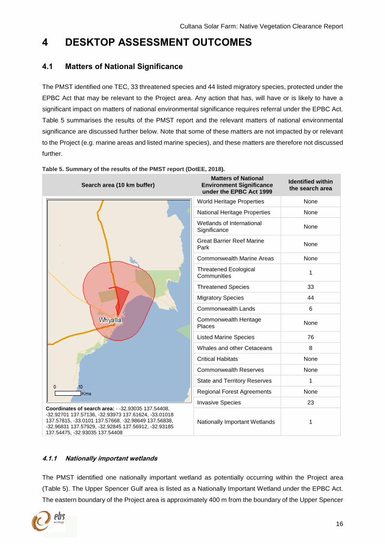
4 DESKTOP ASSESSMENT OUTCOMES
4.1 Matters of National Significance
The PMST identified one TEC, 33 threatened species and 44 listed migratory species, protected under the
EPBC Act that may be relevant to the Project area. Any action that has, will have or is likely to have a
significant impact on matters of national environmental significance requires referral under the EPBC Act.
Table 5 summarises the results of the PMST report and the relevant matters of national environmental
significance are discussed further below. Note that some of these matters are not impacted by or relevant
to the Project (e.g. marine areas and listed marine species), and these matters are therefore not discussed
further.
Table 5. Summary of the results of the PMST report (DotEE, 2018).
Search area (10 km buffer) Matters of National
Environment Significance under the EPBC Act 1999
Identified within the search area
Coordinates of search area: - -32.93035 137.54408, -32.92701 137.57136, -32.93973 137.61624, -33.01018 137.57815, -33.0101 137.57668, -32.98649 137.56838, -32.96831 137.57929, -32.92845 137.56912, -32.93185 137.54475, -32.93035 137.54408
World Heritage Properties None
National Heritage Properties None
Wetlands of International Significance
None
Great Barrier Reef Marine Park
None
Commonwealth Marine Areas None
Threatened Ecological Communities
1
Threatened Species 33
Migratory Species 44
Commonwealth Lands 6
Commonwealth Heritage Places
None
Listed Marine Species 76
Whales and other Cetaceans 8
Critical Habitats None
Commonwealth Reserves None
State and Territory Reserves 1
Regional Forest Agreements None
Invasive Species 23
Nationally Important Wetlands 1
4.1.1 Nationally important wetlands
The PMST identified one nationally important wetland as potentially occurring within the Project area
(Table 5). The Upper Spencer Gulf area is listed as a Nationally Important Wetland under the EPBC Act.
The eastern boundary of the Project area is approximately 400 m from the boundary of the Upper Spencer
Cultana Solar Farm: Native Vegetation Clearance Report
17
Gulf area. The proposed development is not expected to impact on the Upper Spencer Gulf estuary if
construction management measures to limit runoff are implemented.
4.1.2 Commonwealth lands
The PMST identified seven Commonwealth Lands as potentially occurring within the Project area
(Table 5):
Commonwealth Land – unspecified;
Commonwealth Land – Australian National Railways Commission;
Defence – Airtc Whyalla;
Defence – Cultana Training Area;
Defence – El Alamein, Port Augusta; and
Defence – Whyalla Training Depot.
4.1.3 Threatened ecological communities
One TEC was identified by the PMST as potential occurring within the 10 km search buffer of the Project
area (Table 5): Subtropical and Temperate Coastal Saltmarsh (DotEE 2018). Whilst Saltmarsh
communities (Sites A6 and A7) occur within the Project area, they are not considered to qualify as a TEC
as the Project area falls outside the area of tidal influence (due to the Whyalla Saltworks).
4.1.4 Nationally threatened flora
The PMST identified two nationally threatened flora species within the 10 km search buffer of the Project
area (Table 5); Greencomb Spider-orchid (Caladenia tensa) and Braided Sea-heath (Frankenia plicata).
The distributions of both species do no overlap with the Project area, and therefore, they are considered
unlikely to occur within the Project area. Further detail on the likelihood of occurrence of these species in
the Project area is provided in Table 6.
4.1.5 Nationally Threatened fauna
The PMST identified 31 threatened fauna species that have potential to occur within the 10 km search
buffer of the Project area (Table 5). Eight of the species are aquatic marine, and therefore, have been
excluded from this report as the Project area is located upon terrestrial land. One nationally threatened
fauna species; the Western Grasswren (Gawler Ranges) (Amytornis textilis myall), was considered to
potentially occur within the Project area. One additional nationally threatened species; the Western
Whipbird (Psophodes nigrogularis) was identified by the BDBSA search; however, this species is
considered unlikely to occur in the Project area. The rationale for their potential occurrence in the Project
area is provided in Table 6.
The locations of nationally threatened fauna identified by the BDBSA search with records within 10 km of
the Project area are presented in Figure 5.
Cultana Solar Farm: Native Vegetation Clearance Report
18
4.1.6 Migratory fauna
The PMST identified 44 migratory fauna species (not including subspecies) that have potential to occur
within the 10 km search buffer of the Project area (Table 5). Ten (10) of the 44 migratory fauna species,
are aquatic marine species, and therefore, have been excluded from this report. The BDBSA search
identified records for 11 species within 10 km of the Project area, including four species not identified by
the PMST (Table 6). Overall, two migratory fauna species; the Fork-tailed Swift (Apus pacificus) and
Osprey (Pandion haliaetus), have potential to occur within the Project area. Both species would be
expected to be exclusively aerial; however, could on occasion use habitat features in the Project area. A
further 20 migratory species may use the Whyalla Saltfields that are located adjacent to the Project area.
These migratory species using the Whyalla Saltfields could fly-over the Project area during long distance
and migratory flights. The migratory species that would only fly-over the Project area on long distance
flights have been classed as unlikely to occur due to their inability to use habitat features in the Project
area. The rational for the potential occurrence of each migratory fauna species is provided in Table 6.
The locations of migratory fauna identified by the BDBSA search with records within 10 km of the Project
area are presented in Figure 5.
Cultana Solar Farm: Native Vegetation Clearance Report
19
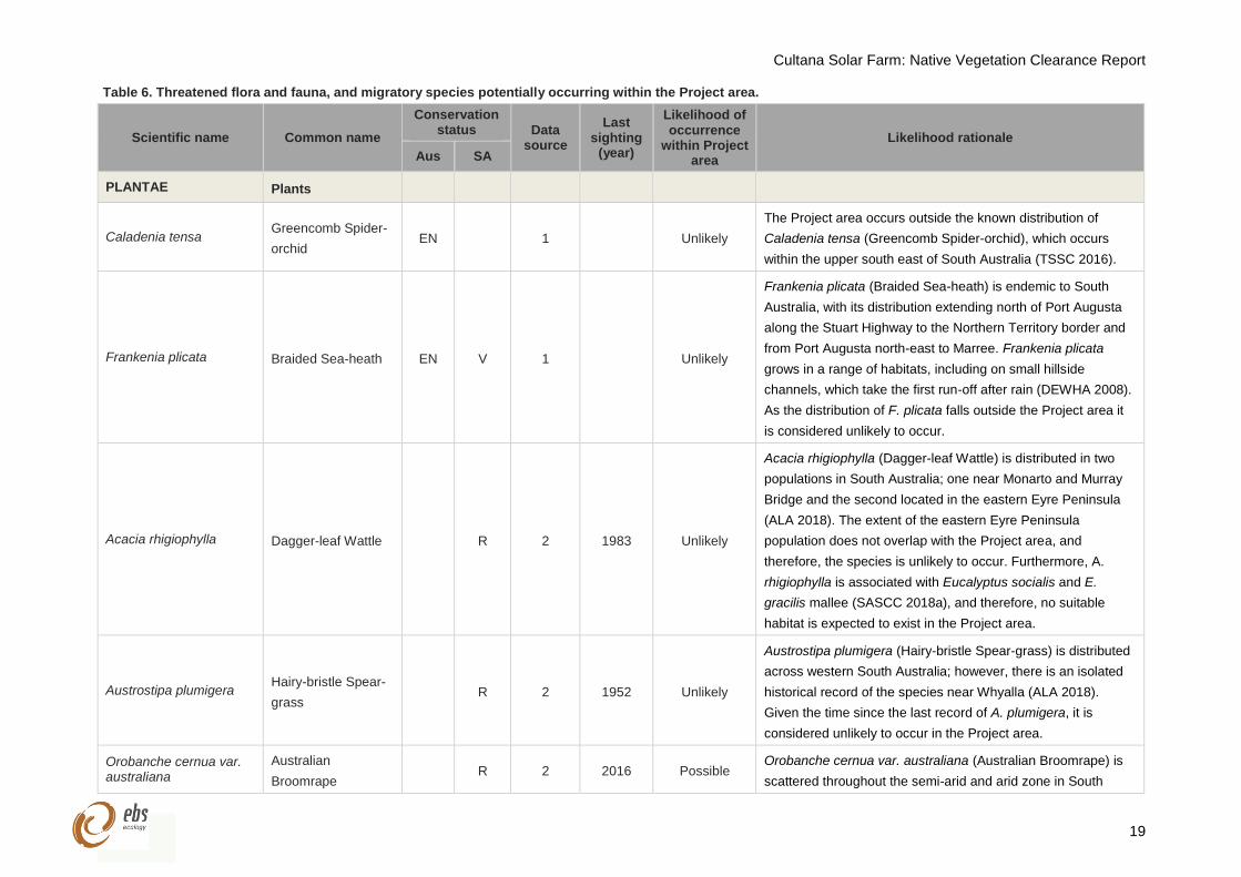
Table 6. Threatened flora and fauna, and migratory species potentially occurring within the Project area.
Scientific name Common name
Conservation status Data
source
Last sighting
(year)
Likelihood of occurrence
within Project area
Likelihood rationale
Aus SA
PLANTAE Plants
Caladenia tensa Greencomb Spider-
orchid EN 1 Unlikely
The Project area occurs outside the known distribution of
Caladenia tensa (Greencomb Spider-orchid), which occurs
within the upper south east of South Australia (TSSC 2016).
Frankenia plicata Braided Sea-heath EN V 1 Unlikely
Frankenia plicata (Braided Sea-heath) is endemic to South
Australia, with its distribution extending north of Port Augusta
along the Stuart Highway to the Northern Territory border and
from Port Augusta north-east to Marree. Frankenia plicata
grows in a range of habitats, including on small hillside
channels, which take the first run-off after rain (DEWHA 2008).
As the distribution of F. plicata falls outside the Project area it
is considered unlikely to occur.
Acacia rhigiophylla Dagger-leaf Wattle R 2 1983 Unlikely
Acacia rhigiophylla (Dagger-leaf Wattle) is distributed in two
populations in South Australia; one near Monarto and Murray
Bridge and the second located in the eastern Eyre Peninsula
(ALA 2018). The extent of the eastern Eyre Peninsula
population does not overlap with the Project area, and
therefore, the species is unlikely to occur. Furthermore, A.
rhigiophylla is associated with Eucalyptus socialis and E.
gracilis mallee (SASCC 2018a), and therefore, no suitable
habitat is expected to exist in the Project area.
Austrostipa plumigera Hairy-bristle Spear-
grass R 2 1952 Unlikely
Austrostipa plumigera (Hairy-bristle Spear-grass) is distributed
across western South Australia; however, there is an isolated
historical record of the species near Whyalla (ALA 2018).
Given the time since the last record of A. plumigera, it is
considered unlikely to occur in the Project area.
Orobanche cernua var. australiana
Australian
Broomrape R 2 2016 Possible
Orobanche cernua var. australiana (Australian Broomrape) is
scattered throughout the semi-arid and arid zone in South
Cultana Solar Farm: Native Vegetation Clearance Report
20
Scientific name Common name
Conservation status Data
source
Last sighting
(year)
Likelihood of occurrence
within Project area
Likelihood rationale
Aus SA
Australia, except for the far west of the state (ALA 2018). There
are recent records near the Whyalla township (ALA 2018).
Therefore, it may occur within the Project area due to the close
proximity of recent records.
Santalum spicatum Sandalwood V 2 1998 Possible
Santalum spicatum (Sandalwood) is scattered throughout
South Australia’s semi-arid zone. The species grows on sands,
sandy loams and clay soils of sand plains, watercourses and
gravelly ridges, mainly in woodland communities (Kutsche and
Lay 2003). The Western Myall (A. papyrocarpa) woodland in
the Project area would comprise suitable habitat for this
species.
AVES Birds
Acanthiza iredalei iredalei
Slender-billed
Thornbill (western) R 2 2016 Likely
The Slender-billed Thornbill (Western) (Acanthiza iredalei
iredalei) is a passerine that inhabits chenopod shrublands that
are dominated by samphires or Maireana and Atriplex
associations (TSSC 2013). The species may also occur in
acacia shrublands. As chenopod shrublands are widespread in
the Project area and the species has been recently recorded
within proximity of the Project area, the Slender-billed Thornbill
(Western) is considered likely to occur.
Actitis hypoleucos Common Sandpiper Mi R 1, 2 2016 Unlikely*
The Common Sandpiper (Actitis hypoleucos) is a shorebird
species that inhabits coastal and inland environments,
including fresh and saline lakes, wetlands and floodwaters
(Pizzey and Knight 2014). The species is expected to use the
Whyalla Saltfields adjacent to the Project area, and therefore,
may also occur as a fly-over in the Project area.
Amytornis textilis myall Western Grasswren
(Gawler Ranges) VU 1, 2 2006 Highly Likely
The Western Grasswren (Amytornis textilis myall) is
considered highly likely to occur within the Project area. This
species was observed within 150 m of the proposed solar
Cultana Solar Farm: Native Vegetation Clearance Report
21
Scientific name Common name
Conservation status Data
source
Last sighting
(year)
Likelihood of occurrence
within Project area
Likelihood rationale
Aus SA
infrastructure by AECOM in 2010 (observed at 53 H 742454 E
6352101 N) (AECOM 2012). The pair of Western Grasswren
were observed within sparse myall woodland over dense
Blackbush (Maireana pyramidata), Pearl Bluebush (Maireana
sedifolia), Bladder Saltbush (Maireana vesicaria) and
copperburrs (Sclerolaena spp.) on red-brown clay-loam
(AECOM 2012). Furthermore, the species has been recorded
at numerous sites within the Whyalla Conservation Park (CP)
(Black et al. 2009), the eastern boundary of which abuts the
proposed transmission line. NatureMaps has identified that
Western Myall (Acacia papyrocarpa) woodland and chenopod
shrublands are located within the solar infrastructure area and
therefore, the suitable habitat is expected to exist, if not, be
widespread (DEW 2018b).
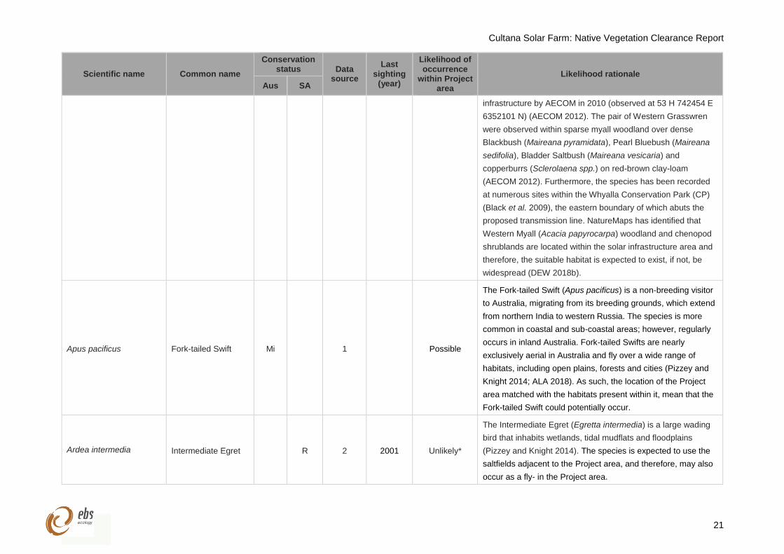
Apus pacificus Fork-tailed Swift Mi 1 Possible
The Fork-tailed Swift (Apus pacificus) is a non-breeding visitor
to Australia, migrating from its breeding grounds, which extend
from northern India to western Russia. The species is more
common in coastal and sub-coastal areas; however, regularly
occurs in inland Australia. Fork-tailed Swifts are nearly
exclusively aerial in Australia and fly over a wide range of
habitats, including open plains, forests and cities (Pizzey and
Knight 2014; ALA 2018). As such, the location of the Project
area matched with the habitats present within it, mean that the
Fork-tailed Swift could potentially occur.
Ardea intermedia Intermediate Egret R 2 2001 Unlikely*
The Intermediate Egret (Egretta intermedia) is a large wading
bird that inhabits wetlands, tidal mudflats and floodplains
(Pizzey and Knight 2014). The species is expected to use the
saltfields adjacent to the Project area, and therefore, may also
occur as a fly- in the Project area.
Cultana Solar Farm: Native Vegetation Clearance Report
22
Scientific name Common name
Conservation status Data
source
Last sighting
(year)
Likelihood of occurrence
within Project area
Likelihood rationale
Aus SA
Ardenna carneipes Flesh-footed
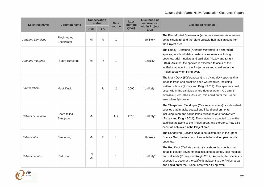
Shearwater Mi R 1 Unlikely
The Flesh-footed Shearwater (Ardenna carneipes) is a marine
pelagic seabird, and therefore suitable habitat is absent from
the Project area.
Arenaria interpres Ruddy Turnstone Mi R 1 Unlikely*
The Ruddy Turnstone (Arenaria interpres) is a shorebird
species, which inhabits coastal environments including
beaches, tidal mudflats and saltfields (Pizzey and Knight
2014). As such, the species is expected to occur at the
saltfields adjacent to the Project area and could enter the
Project area when flying-over.
Biziura lobata Musk Duck R 2 2000 Unlikely*
The Musk Duck (Biziura lobata) is a diving duck species that
inhabits fresh and brackish deep waterbodies, including
wetlands, lakes (Pizzey and Knight 2014). This species could
occur within the saltfields where deeper water (>30 cm) is
available (Pers. Obs.). As such, this could enter the Project
area when flying-over.
Calidris acuminata Sharp-tailed
Sandpiper Mi 1, 2 2015 Unlikely*
The Sharp-tailed Sandpiper (Calidris acuminata) is a shorebird
species that inhabits coastal and inland environments,
including fresh and saline lakes, wetlands and floodwaters
(Pizzey and Knight 2014). The species is expected to use the
saltfields adjacent to the Project area, and therefore, may also
occur as a fly-over in the Project area.
Calidris alba Sanderling Mi R 1 Unlikely
The Sanderling (Calidris alba) is not distributed in the upper
Spence Gulf due to a lack of suitable habitat in open, sandy
beaches.
Calidris canutus Red Knot EN,
Mi 1 Unlikely*
The Red Knot (Calidris canutus) is a shorebird species that
inhabits coastal environments including beaches, tidal mudflats
and saltfields (Pizzey and Knight 2014). As such, the species is
expected to occur at the saltfields adjacent to the Project area
and could enter the Project area when flying-over.
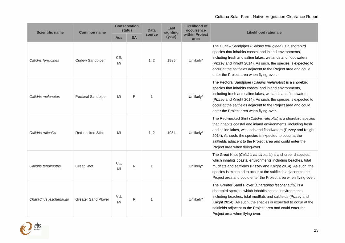
Cultana Solar Farm: Native Vegetation Clearance Report
23
Scientific name Common name
Conservation status Data
source
Last sighting
(year)
Likelihood of occurrence
within Project area
Likelihood rationale
Aus SA
Calidris ferruginea Curlew Sandpiper CE,
Mi 1, 2 1985 Unlikely*
The Curlew Sandpiper (Calidris ferruginea) is a shorebird
species that inhabits coastal and inland environments,
including fresh and saline lakes, wetlands and floodwaters
(Pizzey and Knight 2014). As such, the species is expected to
occur at the saltfields adjacent to the Project area and could
enter the Project area when flying-over.
Calidris melanotos Pectoral Sandpiper Mi R 1 Unlikely*
The Pectoral Sandpiper (Calidris melanotos) is a shorebird
species that inhabits coastal and inland environments,
including fresh and saline lakes, wetlands and floodwaters
(Pizzey and Knight 2014). As such, the species is expected to
occur at the saltfields adjacent to the Project area and could
enter the Project area when flying-over.
Calidris ruficollis Red-necked Stint Mi 1, 2 1984 Unlikely*
The Red-necked Stint (Calidris ruficollis) is a shorebird species
that inhabits coastal and inland environments, including fresh
and saline lakes, wetlands and floodwaters (Pizzey and Knight
2014). As such, the species is expected to occur at the
saltfields adjacent to the Project area and could enter the
Project area when flying-over.
Calidris tenuirostris Great Knot CE,
Mi R 1 Unlikely*
The Great Knot (Calidris tenuirostris) is a shorebird species,
which inhabits coastal environments including beaches, tidal
mudflats and saltfields (Pizzey and Knight 2014). As such, the
species is expected to occur at the saltfields adjacent to the
Project area and could enter the Project area when flying-over.
Charadrius leschenaultii Greater Sand Plover VU,
Mi R 1 Unlikely*
The Greater Sand Plover (Charadrius leschenaultii) is a
shorebird species, which inhabits coastal environments
including beaches, tidal mudflats and saltfields (Pizzey and
Knight 2014). As such, the species is expected to occur at the
saltfields adjacent to the Project area and could enter the
Project area when flying-over.
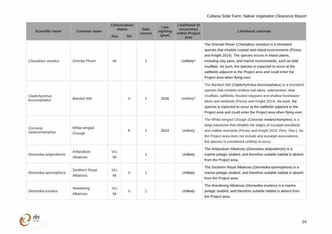
Cultana Solar Farm: Native Vegetation Clearance Report
24
Scientific name Common name
Conservation status Data
source
Last sighting
(year)
Likelihood of occurrence
within Project area
Likelihood rationale
Aus SA
Charadrius veredus Oriental Plover Mi 1 Unlikely*
The Oriental Plover (Charadrius veredus) is a shorebird
species that inhabits coastal and inland environments (Pizzey
and Knight 2014). The species occurs in inland plains,
including clay pans, and marine environments, such as tidal
mudflats. As such, the species is expected to occur at the
saltfields adjacent to the Project area and could enter the
Project area when flying-over.
Cladorhynchus leucocephalus Banded Stilt V 2 2016 Unlikely*
The Banded Stilt (Cladorhynchus leucocephalus) is a shorebird
species that inhabits shallow salt lakes, saltmarshes, tidal
mudflats, saltfields, flooded claypans and shallow freshwater
lakes and wetlands (Pizzey and Knight 2014). As such, the
species is expected to occur at the saltfields adjacent to the
Project area and could enter the Project area when flying-over.
Corcorax melanorhamphos
White-winged
Chough R 2 2014 Unlikely
The White-winged Chough (Corcorax melanorhamphos) is a
large passerine that inhabits the edges of eucalypt woodland
and mallee remnants (Pizzey and Knight 2014; Pers. Obs.). As
the Project area does not include any eucalypt associations,
the species is considered unlikely to occur.
Diomedea antipodensis Antipodean
Albatross
VU,
Mi 1 Unlikely
The Antipodean Albatross (Diomedea antipodensis) is a
marine pelagic seabird, and therefore suitable habitat is absent
from the Project area.
Diomedea epomophora Southern Royal
Albatross
VU,
Mi V 1 Unlikely
The Southern Royal Albatross (Diomedea epomophora) is a
marine pelagic seabird, and therefore suitable habitat is absent
from the Project area.
Diomedea exulans Wandering
Albatross
VU,
Mi V 1 Unlikely
The Wandering Albatross (Diomedea exulans) is a marine
pelagic seabird, and therefore suitable habitat is absent from
the Project area.
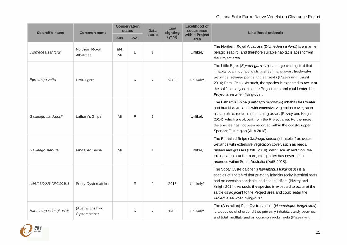
Cultana Solar Farm: Native Vegetation Clearance Report
25
Scientific name Common name
Conservation status Data
source
Last sighting
(year)
Likelihood of occurrence
within Project area
Likelihood rationale
Aus SA
Diomedea sanfordi Northern Royal
Albatross
EN,
Mi E 1 Unlikely
The Northern Royal Albatross (Diomedea sanfordi) is a marine
pelagic seabird, and therefore suitable habitat is absent from
the Project area.
Egretta garzetta Little Egret R 2 2000 Unlikely*
The Little Egret (Egretta garzetta) is a large wading bird that
inhabits tidal mudflats, saltmarshes, mangroves, freshwater
wetlands, sewage ponds and saltfields (Pizzey and Knight
2014; Pers. Obs.). As such, the species is expected to occur at
the saltfields adjacent to the Project area and could enter the
Project area when flying-over.
Gallinago hardwickii Latham’s Snipe Mi R 1 Unlikely
The Latham’s Snipe (Gallinago hardwickii) inhabits freshwater
and brackish wetlands with extensive vegetation cover, such
as samphire, reeds, rushes and grasses (Pizzey and Knight
2014), which are absent from the Project area. Furthermore,
the species has not been recorded within the coastal upper
Spencer Gulf region (ALA 2018).
Gallinago stenura Pin-tailed Snipe Mi 1 Unlikely
The Pin-tailed Snipe (Gallinago stenura) inhabits freshwater
wetlands with extensive vegetation cover, such as reeds,
rushes and grasses (DotE 2018), which are absent from the
Project area. Furthermore, the species has never been
recorded within South Australia (DotE 2018).
Haematopus fuliginosus Sooty Oystercatcher R 2 2016 Unlikely*
The Sooty Oystercatcher (Haematopus fuliginosus) is a
species of shorebird that primarily inhabits rocky intertidal reefs
and on occasion sandspits and tidal mudflats (Pizzey and
Knight 2014). As such, the species is expected to occur at the
saltfields adjacent to the Project area and could enter the
Project area when flying-over.
Haematopus longirostris (Australian) Pied
Oystercatcher R 2 1983 Unlikely*
The (Australian) Pied Oystercatcher (Haematopus longirostris)
is a species of shorebird that primarily inhabits sandy beaches
and tidal mudflats and on occasion rocky reefs (Pizzey and
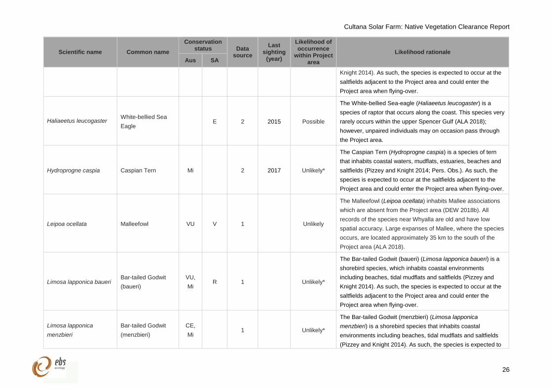
Cultana Solar Farm: Native Vegetation Clearance Report
26
Scientific name Common name
Conservation status Data
source
Last sighting
(year)
Likelihood of occurrence
within Project area
Likelihood rationale
Aus SA
Knight 2014). As such, the species is expected to occur at the
saltfields adjacent to the Project area and could enter the
Project area when flying-over.
Haliaeetus leucogaster White-bellied Sea
Eagle E 2 2015 Possible
The White-bellied Sea-eagle (Haliaeetus leucogaster) is a
species of raptor that occurs along the coast. This species very
rarely occurs within the upper Spencer Gulf (ALA 2018);
however, unpaired individuals may on occasion pass through
the Project area.
Hydroprogne caspia Caspian Tern Mi 2 2017 Unlikely*
The Caspian Tern (Hydroprogne caspia) is a species of tern
that inhabits coastal waters, mudflats, estuaries, beaches and
saltfields (Pizzey and Knight 2014; Pers. Obs.). As such, the
species is expected to occur at the saltfields adjacent to the
Project area and could enter the Project area when flying-over.
Leipoa ocellata Malleefowl VU V 1 Unlikely
The Malleefowl (Leipoa ocellata) inhabits Mallee associations
which are absent from the Project area (DEW 2018b). All
records of the species near Whyalla are old and have low
spatial accuracy. Large expanses of Mallee, where the species
occurs, are located approximately 35 km to the south of the
Project area (ALA 2018).
Limosa lapponica baueri Bar-tailed Godwit
(baueri)
VU,
Mi R 1 Unlikely*
The Bar-tailed Godwit (baueri) (Limosa lapponica baueri) is a
shorebird species, which inhabits coastal environments
including beaches, tidal mudflats and saltfields (Pizzey and
Knight 2014). As such, the species is expected to occur at the
saltfields adjacent to the Project area and could enter the
Project area when flying-over.
Limosa lapponica
menzbieri
Bar-tailed Godwit
(menzbieri)
CE,
Mi 1 Unlikely*
The Bar-tailed Godwit (menzbieri) (Limosa lapponica
menzbieri) is a shorebird species that inhabits coastal
environments including beaches, tidal mudflats and saltfields
(Pizzey and Knight 2014). As such, the species is expected to
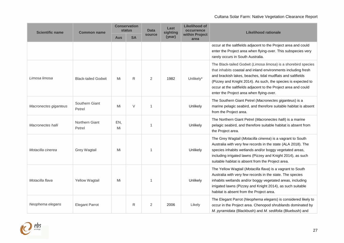
Cultana Solar Farm: Native Vegetation Clearance Report
27
Scientific name Common name
Conservation status Data
source
Last sighting
(year)
Likelihood of occurrence
within Project area
Likelihood rationale
Aus SA
occur at the saltfields adjacent to the Project area and could
enter the Project area when flying-over. This subspecies very
rarely occurs in South Australia.
Limosa limosa Black-tailed Godwit Mi R 2 1982 Unlikely*
The Black-tailed Godwit (Limosa limosa) is a shorebird species
that inhabits coastal and inland environments including fresh
and brackish lakes, beaches, tidal mudflats and saltfields
(Pizzey and Knight 2014). As such, the species is expected to
occur at the saltfields adjacent to the Project area and could
enter the Project area when flying-over.
Macronectes giganteus Southern Giant
Petrel Mi V 1 Unlikely
The Southern Giant Petrel (Macronectes giganteus) is a
marine pelagic seabird, and therefore suitable habitat is absent
from the Project area.
Macronectes halli Northern Giant
Petrel
EN,
Mi 1 Unlikely
The Northern Giant Petrel (Macronectes halli) is a marine
pelagic seabird, and therefore suitable habitat is absent from
the Project area.
Motacilla cinerea Grey Wagtail Mi 1 Unlikely
The Grey Wagtail (Motacilla cinerea) is a vagrant to South
Australia with very few records in the state (ALA 2018). The
species inhabits wetlands and/or boggy vegetated areas,
including irrigated lawns (Pizzey and Knight 2014), as such
suitable habitat is absent from the Project area.
Motacilla flava Yellow Wagtail Mi 1 Unlikely
The Yellow Wagtail (Motacilla flava) is a vagrant to South
Australia with very few records in the state. The species
inhabits wetlands and/or boggy vegetated areas, including
irrigated lawns (Pizzey and Knight 2014), as such suitable
habitat is absent from the Project area.
Neophema elegans Elegant Parrot R 2 2006 Likely
The Elegant Parrot (Neophema elegans) is considered likely to
occur in the Project area. Chenopod shrublands dominated by
M. pyramidata (Blackbush) and M. sedifolia (Bluebush) and
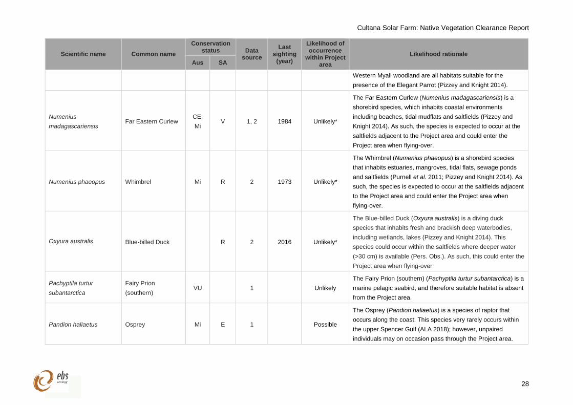
Cultana Solar Farm: Native Vegetation Clearance Report
28
Scientific name Common name
Conservation status Data
source
Last sighting
(year)
Likelihood of occurrence
within Project area
Likelihood rationale
Aus SA
Western Myall woodland are all habitats suitable for the
presence of the Elegant Parrot (Pizzey and Knight 2014).
Numenius
madagascariensis Far Eastern Curlew
CE,
Mi V 1, 2 1984 Unlikely*
The Far Eastern Curlew (Numenius madagascariensis) is a
shorebird species, which inhabits coastal environments
including beaches, tidal mudflats and saltfields (Pizzey and
Knight 2014). As such, the species is expected to occur at the
saltfields adjacent to the Project area and could enter the
Project area when flying-over.
Numenius phaeopus Whimbrel Mi R 2 1973 Unlikely*
The Whimbrel (Numenius phaeopus) is a shorebird species
that inhabits estuaries, mangroves, tidal flats, sewage ponds
and saltfields (Purnell et al. 2011; Pizzey and Knight 2014). As
such, the species is expected to occur at the saltfields adjacent
to the Project area and could enter the Project area when
flying-over.
Oxyura australis Blue-billed Duck R 2 2016 Unlikely*
The Blue-billed Duck (Oxyura australis) is a diving duck
species that inhabits fresh and brackish deep waterbodies,
including wetlands, lakes (Pizzey and Knight 2014). This
species could occur within the saltfields where deeper water
(>30 cm) is available (Pers. Obs.). As such, this could enter the
Project area when flying-over
Pachyptila turtur
subantarctica
Fairy Prion
(southern) VU 1 Unlikely
The Fairy Prion (southern) (Pachyptila turtur subantarctica) is a
marine pelagic seabird, and therefore suitable habitat is absent
from the Project area.
Pandion haliaetus Osprey Mi E 1 Possible
The Osprey (Pandion haliaetus) is a species of raptor that
occurs along the coast. This species very rarely occurs within
the upper Spencer Gulf (ALA 2018); however, unpaired
individuals may on occasion pass through the Project area.
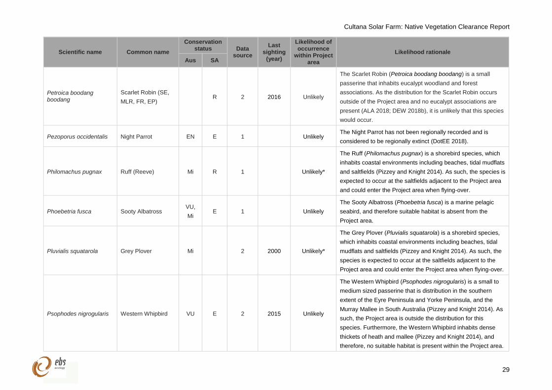
Cultana Solar Farm: Native Vegetation Clearance Report
29
Scientific name Common name
Conservation status Data
source
Last sighting
(year)
Likelihood of occurrence
within Project area
Likelihood rationale
Aus SA
Petroica boodang boodang
Scarlet Robin (SE,
MLR, FR, EP) R 2 2016 Unlikely
The Scarlet Robin (Petroica boodang boodang) is a small
passerine that inhabits eucalypt woodland and forest
associations. As the distribution for the Scarlet Robin occurs
outside of the Project area and no eucalypt associations are
present (ALA 2018; DEW 2018b), it is unlikely that this species
would occur.
Pezoporus occidentalis Night Parrot EN E 1 Unlikely The Night Parrot has not been regionally recorded and is
considered to be regionally extinct (DotEE 2018).
Philomachus pugnax Ruff (Reeve) Mi R 1 Unlikely*
The Ruff (Philomachus pugnax) is a shorebird species, which
inhabits coastal environments including beaches, tidal mudflats
and saltfields (Pizzey and Knight 2014). As such, the species is
expected to occur at the saltfields adjacent to the Project area
and could enter the Project area when flying-over.
Phoebetria fusca Sooty Albatross VU,
Mi E 1 Unlikely
The Sooty Albatross (Phoebetria fusca) is a marine pelagic
seabird, and therefore suitable habitat is absent from the
Project area.
Pluvialis squatarola Grey Plover Mi 2 2000 Unlikely*
The Grey Plover (Pluvialis squatarola) is a shorebird species,
which inhabits coastal environments including beaches, tidal
mudflats and saltfields (Pizzey and Knight 2014). As such, the
species is expected to occur at the saltfields adjacent to the
Project area and could enter the Project area when flying-over.
Psophodes nigrogularis Western Whipbird VU E 2 2015 Unlikely
The Western Whipbird (Psophodes nigrogularis) is a small to
medium sized passerine that is distribution in the southern
extent of the Eyre Peninsula and Yorke Peninsula, and the
Murray Mallee in South Australia (Pizzey and Knight 2014). As
such, the Project area is outside the distribution for this
species. Furthermore, the Western Whipbird inhabits dense
thickets of heath and mallee (Pizzey and Knight 2014), and
therefore, no suitable habitat is present within the Project area.
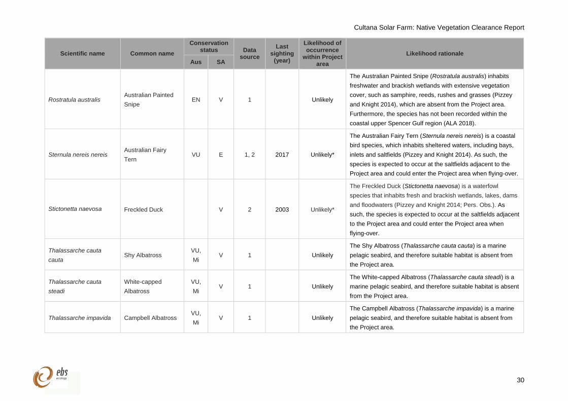
Cultana Solar Farm: Native Vegetation Clearance Report
30
Scientific name Common name
Conservation status Data
source
Last sighting
(year)
Likelihood of occurrence
within Project area
Likelihood rationale
Aus SA
Rostratula australis Australian Painted
Snipe EN V 1 Unlikely
The Australian Painted Snipe (Rostratula australis) inhabits
freshwater and brackish wetlands with extensive vegetation
cover, such as samphire, reeds, rushes and grasses (Pizzey
and Knight 2014), which are absent from the Project area.
Furthermore, the species has not been recorded within the
coastal upper Spencer Gulf region (ALA 2018).
Sternula nereis nereis Australian Fairy
Tern VU E 1, 2 2017 Unlikely*
The Australian Fairy Tern (Sternula nereis nereis) is a coastal
bird species, which inhabits sheltered waters, including bays,
inlets and saltfields (Pizzey and Knight 2014). As such, the
species is expected to occur at the saltfields adjacent to the
Project area and could enter the Project area when flying-over.
Stictonetta naevosa Freckled Duck V 2 2003 Unlikely*
The Freckled Duck (Stictonetta naevosa) is a waterfowl
species that inhabits fresh and brackish wetlands, lakes, dams
and floodwaters (Pizzey and Knight 2014; Pers. Obs.). As
such, the species is expected to occur at the saltfields adjacent
to the Project area and could enter the Project area when
flying-over.
Thalassarche cauta
cauta Shy Albatross
VU,
Mi V 1 Unlikely
The Shy Albatross (Thalassarche cauta cauta) is a marine
pelagic seabird, and therefore suitable habitat is absent from
the Project area.
Thalassarche cauta
steadi
White-capped
Albatross
VU,
Mi V 1 Unlikely
The White-capped Albatross (Thalassarche cauta steadi) is a
marine pelagic seabird, and therefore suitable habitat is absent
from the Project area.
Thalassarche impavida Campbell Albatross VU,
Mi V 1 Unlikely
The Campbell Albatross (Thalassarche impavida) is a marine
pelagic seabird, and therefore suitable habitat is absent from
the Project area.
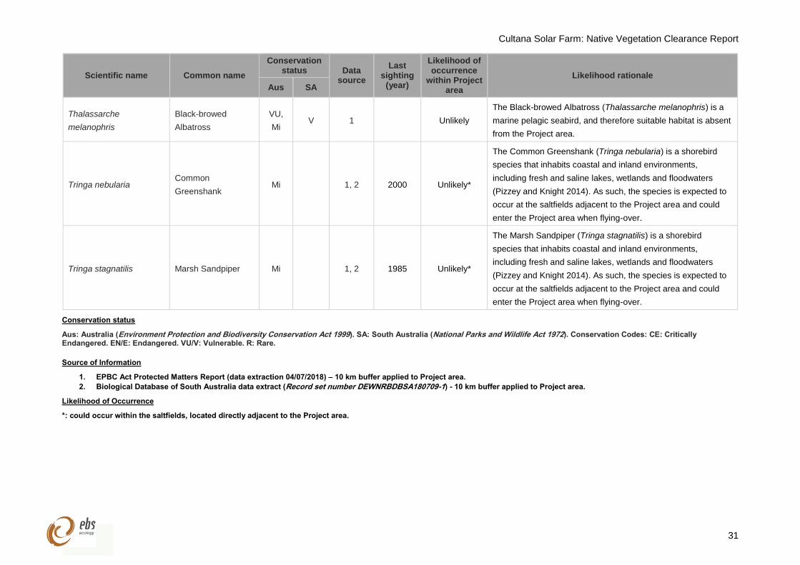
Cultana Solar Farm: Native Vegetation Clearance Report
31
Scientific name Common name
Conservation status Data
source
Last sighting
(year)
Likelihood of occurrence
within Project area
Likelihood rationale
Aus SA
Thalassarche
melanophris
Black-browed
Albatross
VU,
Mi V 1 Unlikely
The Black-browed Albatross (Thalassarche melanophris) is a
marine pelagic seabird, and therefore suitable habitat is absent
from the Project area.
Tringa nebularia Common
Greenshank Mi 1, 2 2000 Unlikely*
The Common Greenshank (Tringa nebularia) is a shorebird
species that inhabits coastal and inland environments,
including fresh and saline lakes, wetlands and floodwaters
(Pizzey and Knight 2014). As such, the species is expected to
occur at the saltfields adjacent to the Project area and could
enter the Project area when flying-over.
Tringa stagnatilis Marsh Sandpiper Mi 1, 2 1985 Unlikely*
The Marsh Sandpiper (Tringa stagnatilis) is a shorebird
species that inhabits coastal and inland environments,
including fresh and saline lakes, wetlands and floodwaters
(Pizzey and Knight 2014). As such, the species is expected to
occur at the saltfields adjacent to the Project area and could
enter the Project area when flying-over.
Conservation status
Aus: Australia (Environment Protection and Biodiversity Conservation Act 1999). SA: South Australia (National Parks and Wildlife Act 1972). Conservation Codes: CE: Critically Endangered. EN/E: Endangered. VU/V: Vulnerable. R: Rare.
Source of Information
1. EPBC Act Protected Matters Report (data extraction 04/07/2018) – 10 km buffer applied to Project area.
2. Biological Database of South Australia data extract (Record set number DEWNRBDBSA180709-1) - 10 km buffer applied to Project area.
Likelihood of Occurrence
*: could occur within the saltfields, located directly adjacent to the Project area.
Cultana Solar Farm: Native Vegetation Clearance Report
32
4.2 Matters of state significance
4.2.1 Threatened ecosystems
No State threatened ecosystems were recorded during the vegetation assessment. Whilst there were
patches of Bullock Bush (Alectryon oleifolius ssp. canescens) they were small and scattered amongst
woodland associations in Block A (A1 and A2). As such, these patches did not qualify as Alectryon
oleifolius ssp. canescens Tall Shrubland, which is listed as Vulnerable under provisional list of threatened
ecosystems of SA (Neagle 2009).
4.2.2 Threatened flora
The BDBSA database search identified four State threatened flora species that have been recorded within
10 km of the Project area (Table 6). One flora species; Sandalwood (Santalum spicatum), was identified
to have potential to occur within the Project area prior to the field assessment. Sandalwood was not
observed during the vegetation assessment and subsequently has been downgraded to unlikely to occur,
as this species is a small tree, and therefore, highly visible. Given this, it is unlikely to it would have
remained undetected during the vegetation assessment. Further detail on the likelihood of occurrence of
State threatened flora species in the Project area is provided in Table 6.
The locations of state threatened flora identified by the BDBSA search with records within 10 km of the
Project area are presented in Figure 4.
4.2.3 Threatened fauna
The BDBSA database search identified a total of 19 State threatened fauna species that have been
recorded within 10 km of the Project area (Table 6). The PMST identified an additional 23 state threatened
species that are also listed as either nationally threatened or migratory. Overall four species could occur
within the Project area:
Two State threatened species may possibly occur within the Project area, the White-bellied Sea
Eagle (Haliaeetus leucogaster) and Osprey (Pandion haliaetus).
Two State threatened species are considered likely to occur in the Project area, the Western
Slender-billed Thornbill (Acanthiza iredalei iredalei) and the Elegant Parrot (Neophema elegans).
The rational for the potential occurrence of each state threatened fauna species is provided in Table 6.
The locations of state threatened fauna identified by the BDBSA search with records within 10 km of the
Project area are presented in Figure 5.
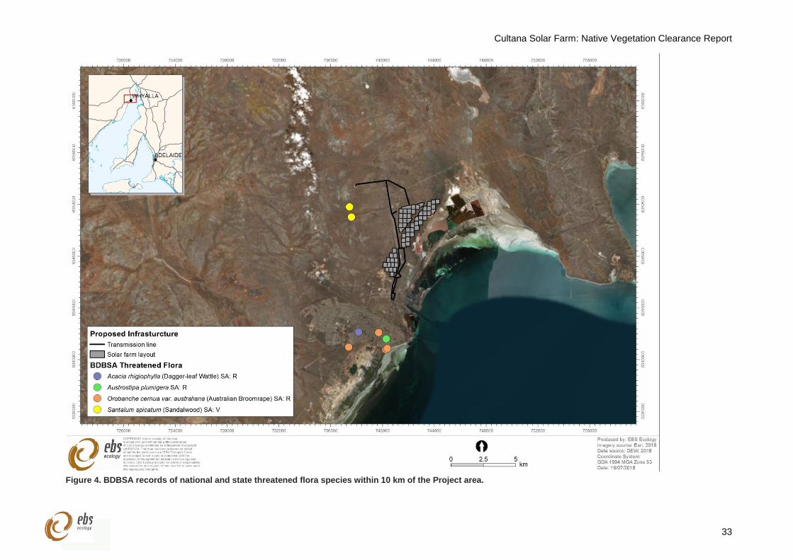
Cultana Solar Farm: Native Vegetation Clearance Report
33
Figure 4. BDBSA records of national and state threatened flora species within 10 km of the Project area.
Cultana Solar Farm: Native Vegetation Clearance Report
34
Figure 5. BDBSA records of national and state threatened fauna within 10 km of the Project area.
Cultana Solar Farm: Native Vegetation Clearance Report
35
5 VEGETATION ASSESSMENT OUTCOMES
The Project area contained two Blocks (Block A and Block B), which were divided by the Lincoln Highway
(Figure 1). A total of eight vegetation associations were mapped within Block A (Table 7) and a RAM /
BAM sample point was established within all associations, except for A2, where two sample points were
surveyed to account for differences in the density of overstorey species. The vegetation within the
proposed transmission line route, on both sides of the Lincoln Highway, was of similar composition and
condition to Block A. Therefore, this vegetation was mapped based on Block A.
In Block B, five associations (Table 7) were mapped and a RAM / BAM sample point was established within
each. Each of the vegetation associations in Block A and Block B are mapped in Figure 6 and Figure 7,
respectively, and summarised in Table 8 to Table 21. See Attachments 1-28 for the RAM and BAM
scoresheets that provide further information on landscape features, dominant and less common species,
weed species, and perennial species’ grazing utilisation for each Site.
The species inventory from the vegetation assessment identified 42 native flora species and four weed
species (Appendix 1). The Project area is likely to contain additional species that were located outside the
one-hectare assessment areas or that are ephemeral and inconspicuous flora species, which are only
likely to be present for short periods following large rainfall events. No flora species that are threatened at
national or state levels were observed during the vegetation assessment.
Weeds were widespread over the Project area. Only one weed species, Ward’s Weed (Carrichtera annua),
was widespread within Block A, while Common Iceplant (Mesembryanthemum crystallinum) was also
common within Block B. Onion Weed (Asphodelus fistulosus) was abundant along the water pipeline within
Block A and Block B. Areas of high disturbance, such as the water pipeline, the former dairy and along
tracks contained the greatest abundance and diversity of weed species in the Project area.
Two Weeds of National Significant (WoNS) listed under the EPBC Act were observed within the Project
area, with few individuals of African Boxthorn (Lycium ferocissimum) present within Block B and isolated
individuals of Prickly Pear (Opuntia stricta) present within Block A. Both WoNS are also declared under
the NRM Act. The only other declared weed species observed over the Project area was Horehound
(Marrubium vulgare), located as a group of few individuals in Block B.
The vegetation within the Project area showed signs of long-term minor grazing from kangaroos and
rabbits. Whilst no palatable shrubs, such as Maireana sedifolia (Pearl Bluebush), were over-utilised, they
on occasion had modified growth forms. Due to the absence of stock grazing, the soil crusts within Block A
and Block B were typically intact except for areas disturbed by the former dairy, vehicles, infrastructure
and illegal dumping.
Cultana Solar Farm: Native Vegetation Clearance Report
36
Table 7. Sites stratified by the two Blocks (A and B) of land and vegetation associations, within the Project
area.
Site Association Area (ha)
A1 Atriplex vesicaria / Maireana pyramidata Low Shrubland 71.32
A2 Casuarina pauper / Acacia papyrocarpa / Myoporum platycarpum Low Open Woodland over Maireana sedifolia +/- Atriplex vesicaria +/- Maireana pyramidata
478.39
A3 Atriplex vesicaria Low Shrubland 131.07
A4 Atriplex vesicaria / Maireana sedifolia +/- Maireana pyramidata Low Shrubland 72.23
A5 Casuarina pauper / Acacia papyrocarpa / Myoporum platycarpum Low Forest over Atriplex vesicaria / Maireana sedifolia +/- Maireana pyramidata
36.00
A6 Tecticornia pergranulata ssp. pergranulata Low Shrubland 6.97
A7 Tecticornia pruinosa / Tecticornia halocnemoides ssp. halocnemoides / Tecticornia indica ssp. leiostachya Low Open Shrubland
25.29
A8 Casuarina pauper / Myoporum platycarpum Very Open Woodland over Atriplex vesicaria / Maireana pyramidata
49.41
B1 Acacia papyrocarpa Low Open Woodland over Atriplex vesicaria / Maireana sedifolia / Maireana pyramidata
98.17
B2 Maireana sedifolia / Atriplex vesicaria Low Shrubland +/- Maireana pyramidata 48.47
B3 Maireana pyramidata Low Shrubland 41.48
B4 Maireana brevifolia /Maireana pyramidata Low Open Shrubland 25.55
B5 Acacia papyrocarpa Low Very Open Woodland over Maireana pyramidata 14.06
Cultana Solar Farm: Native Vegetation Clearance Report
37
Figure 6. Vegetation associations (Sites) within Block A of the Project area.
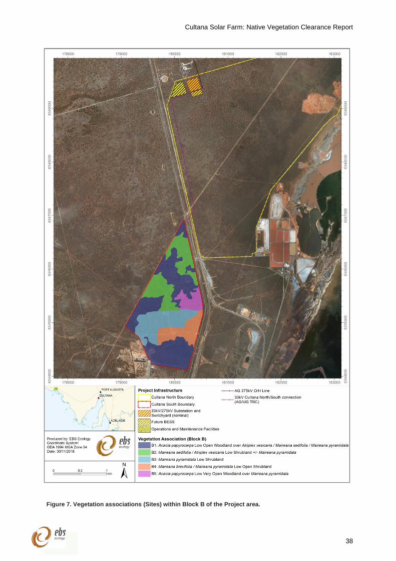
Cultana Solar Farm: Native Vegetation Clearance Report
38
Figure 7. Vegetation associations (Sites) within Block B of the Project area.
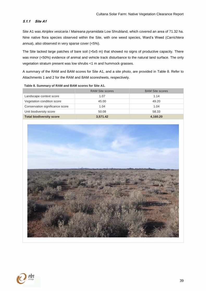
Cultana Solar Farm: Native Vegetation Clearance Report
39
5.1.1 Site A1
Site A1 was Atriplex vesicaria / Maireana pyramidata Low Shrubland, which covered an area of 71.32 ha.
Nine native flora species observed within the Site, with one weed species, Ward’s Weed (Carrichtera
annua), also observed in very sparse cover (<5%).
The Site lacked large patches of bare soil (>5x5 m) that showed no signs of productive capacity. There
was minor (<50%) evidence of animal and vehicle track disturbance to the natural land surface. The only
vegetation stratum present was low shrubs <1 m and hummock grasses.
A summary of the RAM and BAM scores for Site A1, and a site photo, are provided in Table 8. Refer to
Attachments 1 and 2 for the RAM and BAM scoresheets, respectively.
Table 8. Summary of RAM and BAM scores for Site A1.
RAM Site scores BAM Site scores
Landscape context score 1.07 1.14
Vegetation condition score 45.00 49.20
Conservation significance score 1.04 1.04
Unit biodiversity score 50.08 58.33
Total biodiversity score 3,571.42 4,160.20
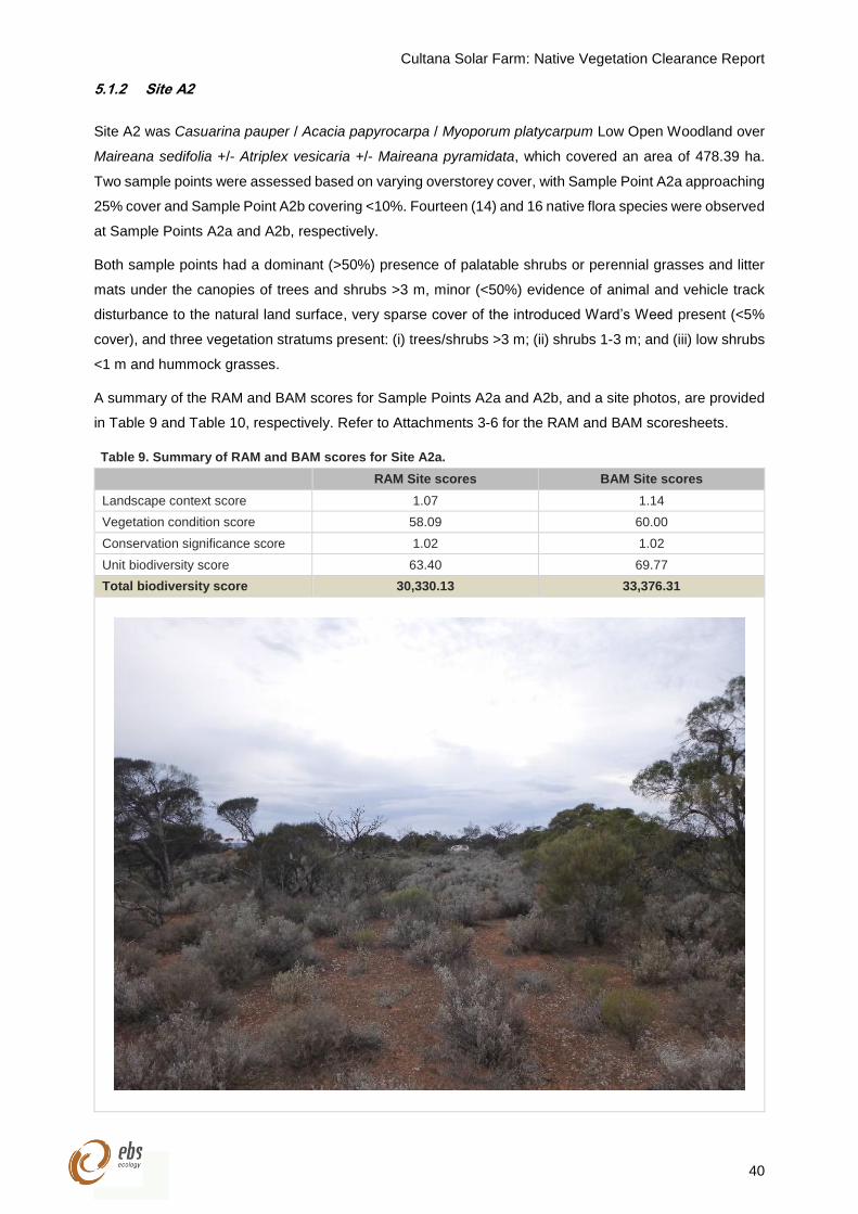
Cultana Solar Farm: Native Vegetation Clearance Report
40
5.1.2 Site A2
Site A2 was Casuarina pauper / Acacia papyrocarpa / Myoporum platycarpum Low Open Woodland over
Maireana sedifolia +/- Atriplex vesicaria +/- Maireana pyramidata, which covered an area of 478.39 ha.
Two sample points were assessed based on varying overstorey cover, with Sample Point A2a approaching
25% cover and Sample Point A2b covering <10%. Fourteen (14) and 16 native flora species were observed
at Sample Points A2a and A2b, respectively.
Both sample points had a dominant (>50%) presence of palatable shrubs or perennial grasses and litter
mats under the canopies of trees and shrubs >3 m, minor (<50%) evidence of animal and vehicle track
disturbance to the natural land surface, very sparse cover of the introduced Ward’s Weed present (<5%
cover), and three vegetation stratums present: (i) trees/shrubs >3 m; (ii) shrubs 1-3 m; and (iii) low shrubs
<1 m and hummock grasses.
A summary of the RAM and BAM scores for Sample Points A2a and A2b, and a site photos, are provided
in Table 9 and Table 10, respectively. Refer to Attachments 3-6 for the RAM and BAM scoresheets.
Table 9. Summary of RAM and BAM scores for Site A2a.
RAM Site scores BAM Site scores
Landscape context score 1.07 1.14
Vegetation condition score 58.09 60.00
Conservation significance score 1.02 1.02
Unit biodiversity score 63.40 69.77
Total biodiversity score 30,330.13 33,376.31
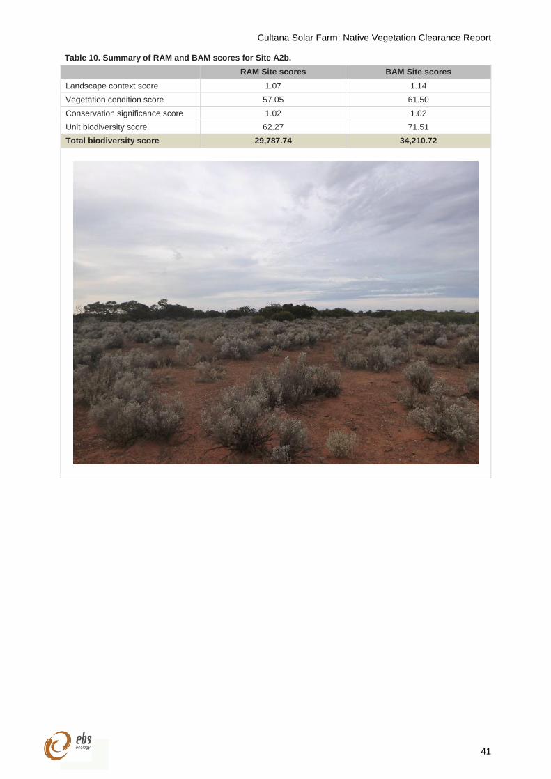
Cultana Solar Farm: Native Vegetation Clearance Report
41
Table 10. Summary of RAM and BAM scores for Site A2b.
RAM Site scores BAM Site scores
Landscape context score 1.07 1.14
Vegetation condition score 57.05 61.50
Conservation significance score 1.02 1.02
Unit biodiversity score 62.27 71.51
Total biodiversity score 29,787.74 34,210.72
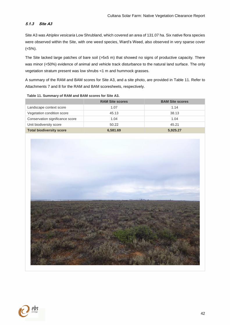
Cultana Solar Farm: Native Vegetation Clearance Report
42
5.1.3 Site A3
Site A3 was Atriplex vesicaria Low Shrubland, which covered an area of 131.07 ha. Six native flora species
were observed within the Site, with one weed species, Ward’s Weed, also observed in very sparse cover
(<5%).
The Site lacked large patches of bare soil (>5x5 m) that showed no signs of productive capacity. There
was minor (<50%) evidence of animal and vehicle track disturbance to the natural land surface. The only
vegetation stratum present was low shrubs <1 m and hummock grasses.
A summary of the RAM and BAM scores for Site A3, and a site photo, are provided in Table 11. Refer to
Attachments 7 and 8 for the RAM and BAM scoresheets, respectively.
Table 11. Summary of RAM and BAM scores for Site A3.
RAM Site scores BAM Site scores
Landscape context score 1.07 1.14
Vegetation condition score 45.13 38.13
Conservation significance score 1.04 1.04
Unit biodiversity score 50.22 45.21
Total biodiversity score 6,581.69 5,925.27
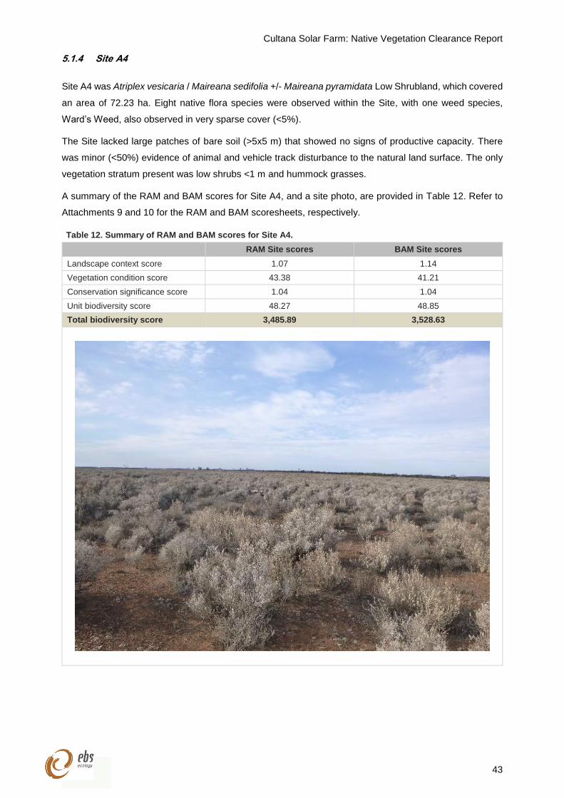
Cultana Solar Farm: Native Vegetation Clearance Report
43
5.1.4 Site A4
Site A4 was Atriplex vesicaria / Maireana sedifolia +/- Maireana pyramidata Low Shrubland, which covered
an area of 72.23 ha. Eight native flora species were observed within the Site, with one weed species,
Ward’s Weed, also observed in very sparse cover (<5%).
The Site lacked large patches of bare soil (>5x5 m) that showed no signs of productive capacity. There
was minor (<50%) evidence of animal and vehicle track disturbance to the natural land surface. The only
vegetation stratum present was low shrubs <1 m and hummock grasses.
A summary of the RAM and BAM scores for Site A4, and a site photo, are provided in Table 12. Refer to
Attachments 9 and 10 for the RAM and BAM scoresheets, respectively.
Table 12. Summary of RAM and BAM scores for Site A4.
RAM Site scores BAM Site scores
Landscape context score 1.07 1.14
Vegetation condition score 43.38 41.21
Conservation significance score 1.04 1.04
Unit biodiversity score 48.27 48.85
Total biodiversity score 3,485.89 3,528.63
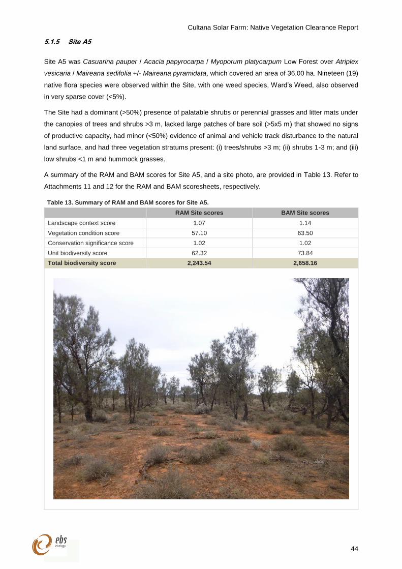
Cultana Solar Farm: Native Vegetation Clearance Report
44
5.1.5 Site A5
Site A5 was Casuarina pauper / Acacia papyrocarpa / Myoporum platycarpum Low Forest over Atriplex
vesicaria / Maireana sedifolia +/- Maireana pyramidata, which covered an area of 36.00 ha. Nineteen (19)
native flora species were observed within the Site, with one weed species, Ward’s Weed, also observed
in very sparse cover (<5%).
The Site had a dominant (>50%) presence of palatable shrubs or perennial grasses and litter mats under
the canopies of trees and shrubs >3 m, lacked large patches of bare soil (>5x5 m) that showed no signs
of productive capacity, had minor (<50%) evidence of animal and vehicle track disturbance to the natural
land surface, and had three vegetation stratums present: (i) trees/shrubs >3 m; (ii) shrubs 1-3 m; and (iii)
low shrubs <1 m and hummock grasses.
A summary of the RAM and BAM scores for Site A5, and a site photo, are provided in Table 13. Refer to
Attachments 11 and 12 for the RAM and BAM scoresheets, respectively.
Table 13. Summary of RAM and BAM scores for Site A5.
RAM Site scores BAM Site scores
Landscape context score 1.07 1.14
Vegetation condition score 57.10 63.50
Conservation significance score 1.02 1.02
Unit biodiversity score 62.32 73.84
Total biodiversity score 2,243.54 2,658.16
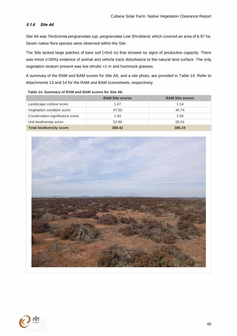
Cultana Solar Farm: Native Vegetation Clearance Report
45
5.1.6 Site A6
Site A6 was Tecticornia pergranulata ssp. pergranulata Low Shrubland, which covered an area of 6.97 ha.
Seven native flora species were observed within the Site.
The Site lacked large patches of bare soil (>5x5 m) that showed no signs of productive capacity. There
was minor (<50%) evidence of animal and vehicle track disturbance to the natural land surface. The only
vegetation stratum present was low shrubs <1 m and hummock grasses.
A summary of the RAM and BAM scores for Site A6, and a site photo, are provided in Table 14. Refer to
Attachments 13 and 14 for the RAM and BAM scoresheets, respectively.
Table 14. Summary of RAM and BAM scores for Site A6.
RAM Site scores BAM Site scores
Landscape context score 1.07 1.14
Vegetation condition score 47.50 46.74
Conservation significance score 1.04 1.04
Unit biodiversity score 52.86 55.41
Total biodiversity score 368.42 386.24
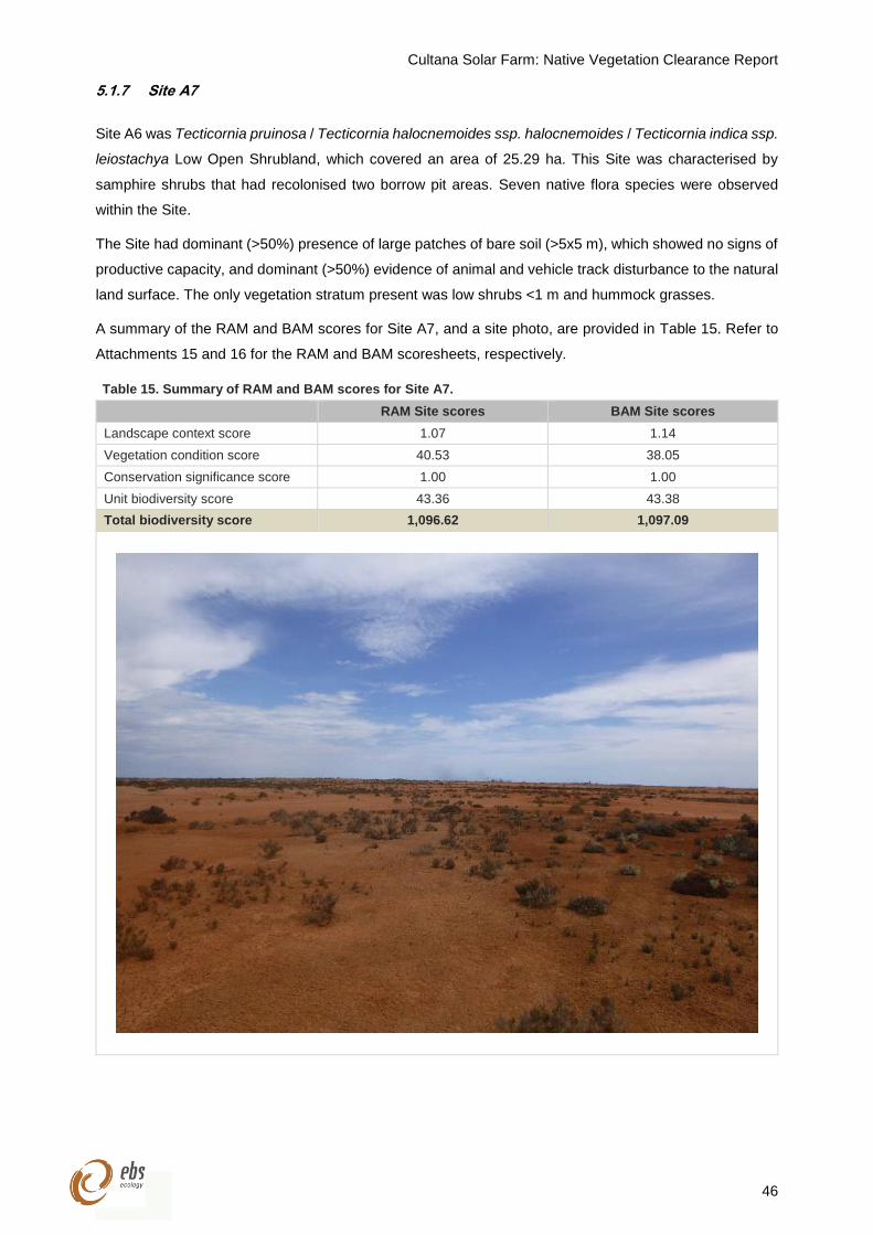
Cultana Solar Farm: Native Vegetation Clearance Report
46
5.1.7 Site A7
Site A6 was Tecticornia pruinosa / Tecticornia halocnemoides ssp. halocnemoides / Tecticornia indica ssp.
leiostachya Low Open Shrubland, which covered an area of 25.29 ha. This Site was characterised by
samphire shrubs that had recolonised two borrow pit areas. Seven native flora species were observed
within the Site.
The Site had dominant (>50%) presence of large patches of bare soil (>5x5 m), which showed no signs of
productive capacity, and dominant (>50%) evidence of animal and vehicle track disturbance to the natural
land surface. The only vegetation stratum present was low shrubs <1 m and hummock grasses.
A summary of the RAM and BAM scores for Site A7, and a site photo, are provided in Table 15. Refer to
Attachments 15 and 16 for the RAM and BAM scoresheets, respectively.
Table 15. Summary of RAM and BAM scores for Site A7.
RAM Site scores BAM Site scores
Landscape context score 1.07 1.14
Vegetation condition score 40.53 38.05
Conservation significance score 1.00 1.00
Unit biodiversity score 43.36 43.38
Total biodiversity score 1,096.62 1,097.09
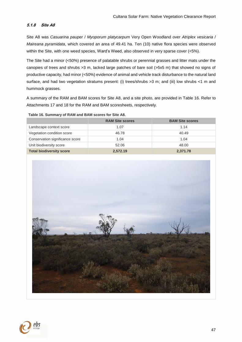
Cultana Solar Farm: Native Vegetation Clearance Report
47
5.1.8 Site A8
Site A8 was Casuarina pauper / Myoporum platycarpum Very Open Woodland over Atriplex vesicaria /
Maireana pyramidata, which covered an area of 49.41 ha. Ten (10) native flora species were observed
within the Site, with one weed species, Ward’s Weed, also observed in very sparse cover (<5%).
The Site had a minor (<50%) presence of palatable shrubs or perennial grasses and litter mats under the
canopies of trees and shrubs >3 m, lacked large patches of bare soil (>5x5 m) that showed no signs of
productive capacity, had minor (<50%) evidence of animal and vehicle track disturbance to the natural land
surface, and had two vegetation stratums present: (i) trees/shrubs >3 m; and (iii) low shrubs <1 m and
hummock grasses.
A summary of the RAM and BAM scores for Site A8, and a site photo, are provided in Table 16. Refer to
Attachments 17 and 18 for the RAM and BAM scoresheets, respectively.
Table 16. Summary of RAM and BAM scores for Site A8.
RAM Site scores BAM Site scores
Landscape context score 1.07 1.14
Vegetation condition score 46.78 40.49
Conservation significance score 1.04 1.04
Unit biodiversity score 52.06 48.00
Total biodiversity score 2,572.19 2,371.78
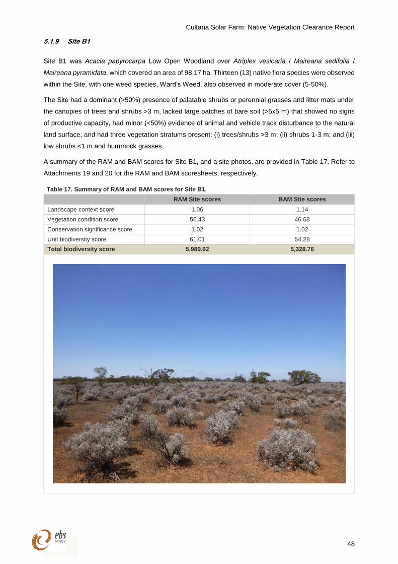
Cultana Solar Farm: Native Vegetation Clearance Report
48
5.1.9 Site B1
Site B1 was Acacia papyrocarpa Low Open Woodland over Atriplex vesicaria / Maireana sedifolia /
Maireana pyramidata, which covered an area of 98.17 ha. Thirteen (13) native flora species were observed
within the Site, with one weed species, Ward’s Weed, also observed in moderate cover (5-50%).
The Site had a dominant (>50%) presence of palatable shrubs or perennial grasses and litter mats under
the canopies of trees and shrubs >3 m, lacked large patches of bare soil (>5x5 m) that showed no signs
of productive capacity, had minor (<50%) evidence of animal and vehicle track disturbance to the natural
land surface, and had three vegetation stratums present: (i) trees/shrubs >3 m; (ii) shrubs 1-3 m; and (iii)
low shrubs <1 m and hummock grasses.
A summary of the RAM and BAM scores for Site B1, and a site photos, are provided in Table 17. Refer to
Attachments 19 and 20 for the RAM and BAM scoresheets, respectively.
Table 17. Summary of RAM and BAM scores for Site B1.
RAM Site scores BAM Site scores
Landscape context score 1.06 1.14
Vegetation condition score 56.43 46.68
Conservation significance score 1.02 1.02
Unit biodiversity score 61.01 54.28
Total biodiversity score 5,989.62 5,328.76
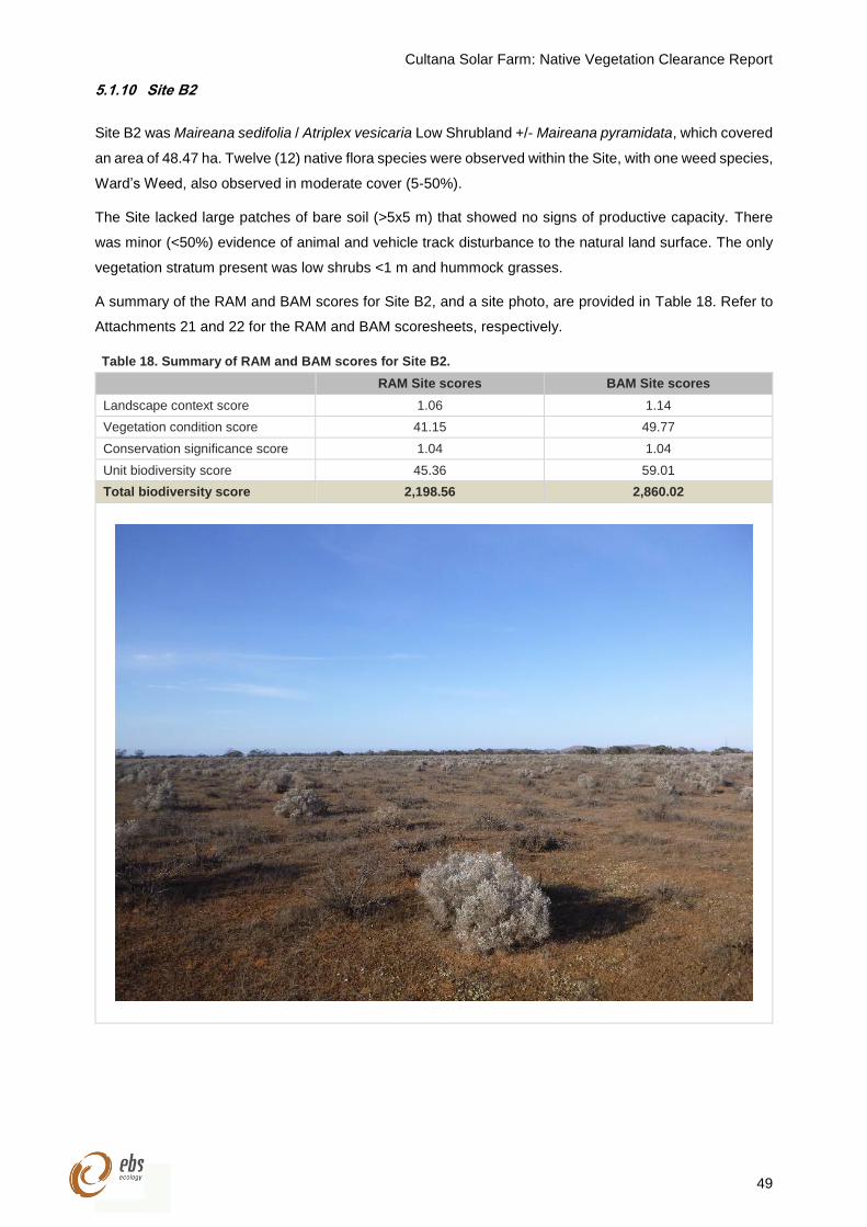
Cultana Solar Farm: Native Vegetation Clearance Report
49
5.1.10 Site B2
Site B2 was Maireana sedifolia / Atriplex vesicaria Low Shrubland +/- Maireana pyramidata, which covered
an area of 48.47 ha. Twelve (12) native flora species were observed within the Site, with one weed species,
Ward’s Weed, also observed in moderate cover (5-50%).
The Site lacked large patches of bare soil (>5x5 m) that showed no signs of productive capacity. There
was minor (<50%) evidence of animal and vehicle track disturbance to the natural land surface. The only
vegetation stratum present was low shrubs <1 m and hummock grasses.
A summary of the RAM and BAM scores for Site B2, and a site photo, are provided in Table 18. Refer to
Attachments 21 and 22 for the RAM and BAM scoresheets, respectively.
Table 18. Summary of RAM and BAM scores for Site B2.
RAM Site scores BAM Site scores
Landscape context score 1.06 1.14
Vegetation condition score 41.15 49.77
Conservation significance score 1.04 1.04
Unit biodiversity score 45.36 59.01
Total biodiversity score 2,198.56 2,860.02
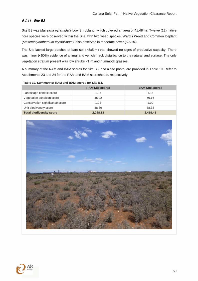
Cultana Solar Farm: Native Vegetation Clearance Report
50
5.1.11 Site B3
Site B3 was Maireana pyramidata Low Shrubland, which covered an area of 41.48 ha. Twelve (12) native
flora species were observed within the Site, with two weed species, Ward’s Weed and Common Iceplant
(Mesembryanthemum crystallinum), also observed in moderate cover (5-50%).
The Site lacked large patches of bare soil (>5x5 m) that showed no signs of productive capacity. There
was minor (<50%) evidence of animal and vehicle track disturbance to the natural land surface. The only
vegetation stratum present was low shrubs <1 m and hummock grasses.
A summary of the RAM and BAM scores for Site B3, and a site photo, are provided in Table 19. Refer to
Attachments 23 and 24 for the RAM and BAM scoresheets, respectively.
Table 19. Summary of RAM and BAM scores for Site B3.
RAM Site scores BAM Site scores
Landscape context score 1.06 1.14
Vegetation condition score 45.22 50.16
Conservation significance score 1.02 1.02
Unit biodiversity score 48.89 58.33
Total biodiversity score 2,028.13 2,419.41
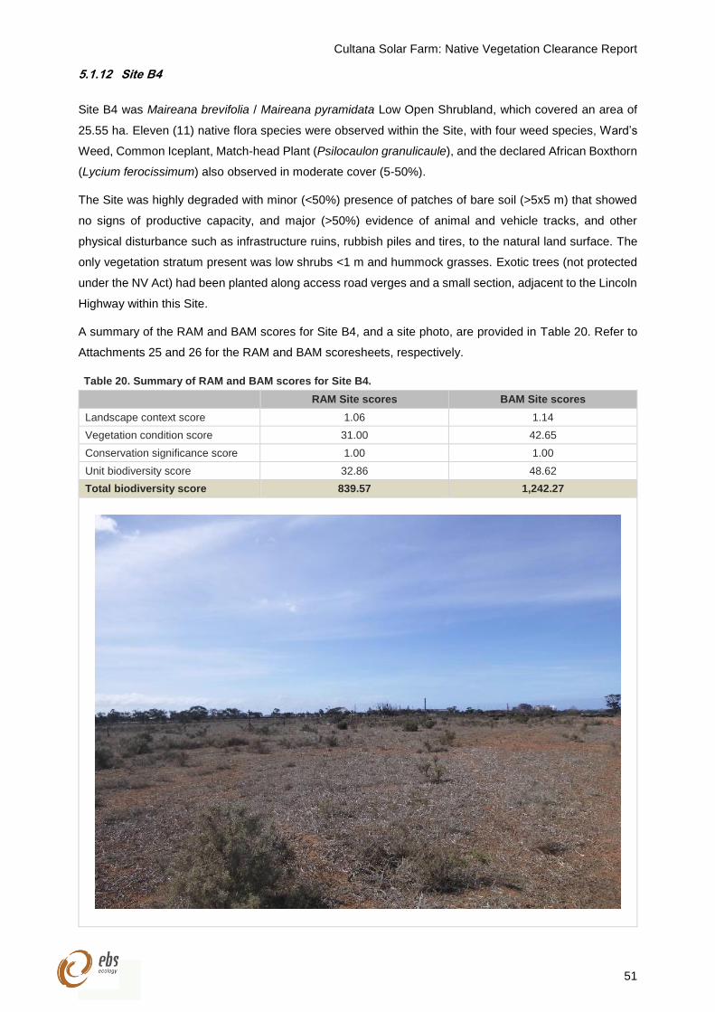
Cultana Solar Farm: Native Vegetation Clearance Report
51
5.1.12 Site B4
Site B4 was Maireana brevifolia / Maireana pyramidata Low Open Shrubland, which covered an area of
25.55 ha. Eleven (11) native flora species were observed within the Site, with four weed species, Ward’s
Weed, Common Iceplant, Match-head Plant (Psilocaulon granulicaule), and the declared African Boxthorn
(Lycium ferocissimum) also observed in moderate cover (5-50%).
The Site was highly degraded with minor (<50%) presence of patches of bare soil (>5x5 m) that showed
no signs of productive capacity, and major (>50%) evidence of animal and vehicle tracks, and other
physical disturbance such as infrastructure ruins, rubbish piles and tires, to the natural land surface. The
only vegetation stratum present was low shrubs <1 m and hummock grasses. Exotic trees (not protected
under the NV Act) had been planted along access road verges and a small section, adjacent to the Lincoln
Highway within this Site.
A summary of the RAM and BAM scores for Site B4, and a site photo, are provided in Table 20. Refer to
Attachments 25 and 26 for the RAM and BAM scoresheets, respectively.
Table 20. Summary of RAM and BAM scores for Site B4.
RAM Site scores BAM Site scores
Landscape context score 1.06 1.14
Vegetation condition score 31.00 42.65
Conservation significance score 1.00 1.00
Unit biodiversity score 32.86 48.62
Total biodiversity score 839.57 1,242.27
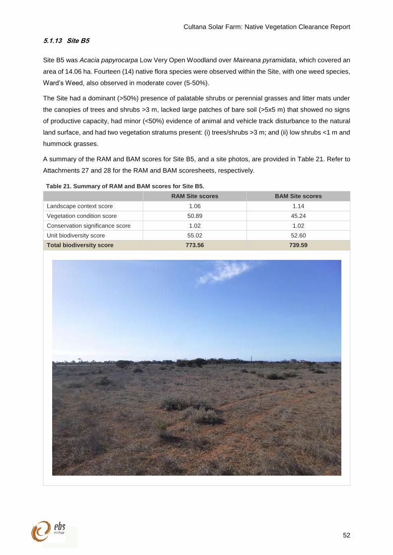
Cultana Solar Farm: Native Vegetation Clearance Report
52
5.1.13 Site B5
Site B5 was Acacia papyrocarpa Low Very Open Woodland over Maireana pyramidata, which covered an
area of 14.06 ha. Fourteen (14) native flora species were observed within the Site, with one weed species,
Ward’s Weed, also observed in moderate cover (5-50%).
The Site had a dominant (>50%) presence of palatable shrubs or perennial grasses and litter mats under
the canopies of trees and shrubs >3 m, lacked large patches of bare soil (>5x5 m) that showed no signs
of productive capacity, had minor (<50%) evidence of animal and vehicle track disturbance to the natural
land surface, and had two vegetation stratums present: (i) trees/shrubs >3 m; and (ii) low shrubs <1 m and
hummock grasses.
A summary of the RAM and BAM scores for Site B5, and a site photos, are provided in Table 21. Refer to
Attachments 27 and 28 for the RAM and BAM scoresheets, respectively.
Table 21. Summary of RAM and BAM scores for Site B5.
RAM Site scores BAM Site scores
Landscape context score 1.06 1.14
Vegetation condition score 50.89 45.24
Conservation significance score 1.02 1.02
Unit biodiversity score 55.02 52.60
Total biodiversity score 773.56 739.59
Cultana Solar Farm: Native Vegetation Clearance Report
53
6 FAUNA ASSESSMENT OUTCOMES
6.1 Birds
A total of 384 birds from 39 species were recorded during point counts and opportunistically within the
Project area (Appendix 1 and Appendix 2). The families of birds with the greatest representation were
Meliphagidae (Honeyeaters; six species), Acanthizidae (Australian Warblers; five species) and Artamidae
(Currawongs, Butcherbirds, Magpies, Woodswallows; four species). The 16-point count sites recorded 33
bird species (Appendix 2). Overall, the most abundant species were the White-browed Babbler
(Pomatostomus superciliosus; 34 individuals), Spiney-cheeked Honeyeater (Acanthagenys rufogularis; 31
individuals) and Variegated Fairywren (Malurus lamberti; 19 individuals). There were no species of state
of national significance recorded within the Project area. One introduced bird species; the Common
Starling (Sturnus vulgaris) was observed within the Project area.
There were no Western Grasswrens observed in the Project area nor areas of their preferred habitat, due
to the absence of minor drainage lines which supported large spiny shrubs (>0.75 m) in high densities.
However, there were 43.19 ha of potential habitat identified, where Maireana pyramidata (Blackbush)
shrubs were dense and frequently greater than 50 cm in height, and present in either shrubland or within
open Acacia papyrocarpa (Western Myall) and/or Casuarina pauper (Black Oak) woodland. All other
habitat within the Project area would be atypical for the species.
6.2 Mammals
Four mammal species were recorded over the Project area, which was comprised of two indigenous and
two introduced species. The two indigenous species were macropods, with six Red Kangaroos (Macropus
rufus) and four Western Grey Kangaroos (Macropus fuliginosus) observed. The introduced species
recorded were two foxes (Vulpes vulpes) and a single rabbit (Oryctolagus cuniculus). A potentially active
fox den and an in-active rabbit warrens were also observed within the Project area.
6.3 Reptiles
Five reptile species were observed over the Project area. The five species observed were the Crested
Dragon (Ctenophorus cristatus), Spotted Ctenotus (Ctenotus orientalis), Yellow-faced Whipsnake
(Demansia psammophis), Central Bearded Dragon (Pogona vitticeps) and Sleepy Lizard (Tiliqua rugosa).
The Sleep Lizard and Central Bearded Dragon were the most commonly observed species, with six and
three individuals recorded, respectively, while all other reptile species were represented by a lone
individual.
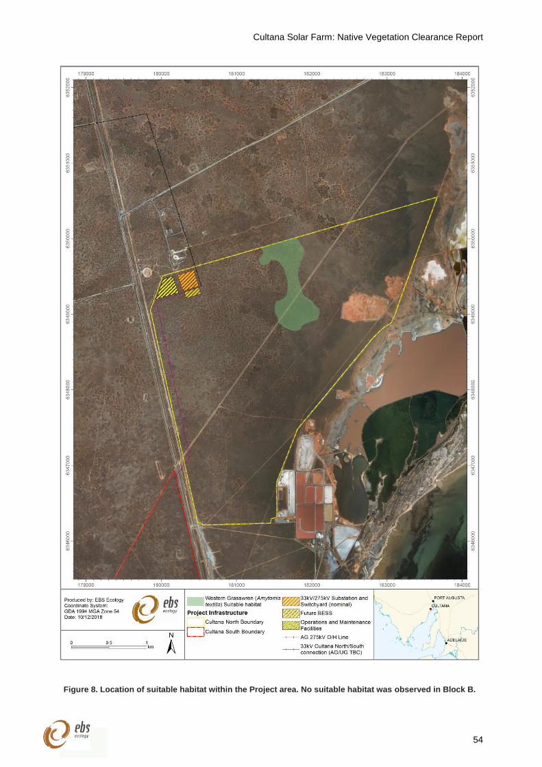
Cultana Solar Farm: Native Vegetation Clearance Report
54
Figure 8. Location of suitable habitat within the Project area. No suitable habitat was observed in Block B.
Cultana Solar Farm: Native Vegetation Clearance Report
55
7 REQUIREMENTS OF THE REGULATION
7.1 Regulation under which the clearance is applicable
An assessment against the Native Vegetation Clearance Principles is not required as the clearance
associated with the Project is exempt under the following regulation:
Regulation 12(34)—Infrastructure
(1) Clearance of vegetation—
(a) incidental to the construction or expansion of a building or infrastructure where the Minister
has, by instrument in writing, declared that the Minister is satisfied that the clearance is in
the public interest; or
(b) required in connection with the provision of infrastructure or services to a building or
proposed building, or to any place,
provided that any development authorisation required by or under the Development Act 1993 has
been obtained.
The requirements of the proponent to undertake clearance for the provision of infrastructure include:
Application to the NVC;
Provision of sufficient information for the NVC to assess the level of risk to biodiversity;
Development of a SEB Management Plan to be approved by the NVC if providing an on ground
SEB; and
Provision of a SEB in accordance with the Management Plan or payment into the Native
Vegetation Fund.
If an NVC-approved Standard Operating Procedure (SOP) exists, the application, assessment, approval
and SEB processes will occur in accordance with the SOP.
Cultana Solar Farm: Native Vegetation Clearance Report
56
7.2 Risk assessment
The proposed Project involves level 4 clearance since the Total Biodiversity Score for the Project area
(RAM = 61,827.92. BAM = 66,510.94) is greater than 2,500. The proposed clearance is not ‘Seriously at
Variance’ with Principles of Clearance 1(b), 1(c) or 1(d), as summarised below for each Principle.
7.2.1 Principle (b) It has significance as a habitat for wildlife
Each Site in the Project area has a threatened fauna score ranging from 0-0.04 and therefore clearance is
not ‘At Variance’ with Principle (b).
7.2.2 Principle (c) It includes plants of a rare, vulnerable or endangered species
All Sites within the Project area have a threatened flora score of 0 and therefore clearance is not ‘At
Variance’ with Principle (c).
7.2.3 Principle (d) The vegetation comprises the whole, or part, of a plant community that is
Rare, Vulnerable or Endangered
No Rare, Vulnerable or Endangered plant communities are present in the Project area and therefore
clearance of vegetation is not ‘At Variance’ with Principle (d).
Cultana Solar Farm: Native Vegetation Clearance Report
57
8 MITIGATION HIERARCHY
Measures to avoid clearance of native vegetation, minimise the extent, duration and intensity of impacts
of the clearance on biodiversity to the fullest possible extent, and rehabilitate ecosystems that have been
degraded, and to restore ecosystems that have been degraded, or destroyed by the impact of clearance
for certain aspects of Project area discussed below.
8.1 Borrow pits
8.1.1 Vegetation Impact
Vegetation cover within the borrow pits areas (Site A7) is currently quite low. Pending economic
evaluations, it is intended to avoid construction or any impact in these areas. The borrow pits are intended
to be left to naturally rehabilitate over time but can be actively rehabilitated by direct-seeding.
8.1.2 Justification
These sites are not ideal for a solar farm. Natural rehabilitation may be the most favourable option
with regards to economics and vegetation impact; and
Due to the lack of vegetation in these areas, the location will be particularly sensitive to disturbance
with regards to dust-borne pollution.
8.2 Dense Myall Woodlands
8.2.1 Vegetation Impact
There is dense Myall (Acacia papyrocarpa) Woodland vegetation in the central parts, and a small section
near the northern boundary, of the Block A (Site A5). It is recognised that construction in the dense areas
may be difficult. As such, the Project is considering leaving these areas undeveloped.
8.2.2 Justification
These sites are not ideal for a solar farm. Natural conservation is a favourable option with regards
to economics and vegetation impact; and
The dense vegetation is recognised as slow-growing and comparatively valuable from an
ecological perspective. Retention of the dense vegetation will reduce impact on fauna.
8.3 Low density trees in chenopod shrubland
8.3.1 Vegetation Impact
Occasional trees and larger shrubs exist across both Block A and Block B. Where these trees or shrubs
can be managed in height and do not present any issues with construction, they will be left as-is. Where
vegetation removal is necessary, the intent is to remove only the part of the vegetation above the natural
ground level and leave the root system and soil structure in-situ. Complete removal of trees and their roots
will be carried out by exception where there are no other economical alternatives.
Cultana Solar Farm: Native Vegetation Clearance Report
58
Generally, shrubs with trunk diameters less than 100mm will be able to be rolled or have their heights
managed during construction. For the operational life of the Solar Farm, these shrubs will be managed
actively based on their height. Shrubs and trees with diameters greater than 150mm are sparsely scattered
across the development site and are intended to be assessed and addressed on a case-by-case basis.
It is recognized that any vegetation to be kept on site within the main development areas will need to be
maintained at a height of approximately 500mm within the central zones. Where vegetation does not impact
production or operation of the Solar Farm, the vegetation will be left as-is.
8.3.2 Justification
The most economical approach coincides with minimising the environmental footprint of
construction. Most of the impacted vegetation during construction is anticipated to fully recover
over time;
Encouragement of native vegetation on site will inherently discourage rising of the salt table;
Vegetation height management activities are anticipated to occur on an as-required basis; and
Where trees or vegetation is removed, impacted areas will be rehabilitated either by direct seeding
or natural dispersion of adjacent vegetation.
8.4 General chenopod shrubland
8.4.1 Vegetation Impact
Nominally, it is anticipated the minimum clearance from the solar panels (at their lowest positions) to the
ground is 500 mm. The entirety of the development area will be maintained and managed as-required.
8.4.2 Justification
Encouragement of native vegetation on site will inherently discourage rising of the salt table;
Vegetation under panels will reduce reflection of heat underneath panels and stabilize/reduce
operating temperatures, thereby improving reliability of the Solar Farm; and
Vegetation will reduce the severity of windblown dust and dirt onto the solar panels.
8.5 High voltage overhead powerlines (275kV)
8.5.1 Vegetation Impact
The proposed route for the high voltage powerline that connects the Solar Farm to the grid runs through
relatively dense Myall Woodland. Where possible, existing access tracks will be used to reduce impact.
Where new access tracks are required, consideration is being given to using a roller to crush the vegetation
to provide vehicular access. Occasional vehicular movement will then maintain vegetation heights and
growth.
Vegetation below the powerlines will be trimmed and managed as per Attachment 29. Where possible,
trees and tall shrubs will have vegetation heights maintained in preference to clearance. Removal of trees
Cultana Solar Farm: Native Vegetation Clearance Report
59
or tall shrubs will be carried out only where no economical alternative is available. Low lying shrubs will
not be impacted. All vegetation impacted will remain on site.
To install the powerline towers, the footprints underneath the towers will be totally cleared. Cleared
vegetation will remain onsite in an adjacent area. Mulching/chipping of the vegetation will be considered.
To connect the Solar Farm to the grid, approximately 6 km of overhead powerlines are required.
Approximately 3.1 km of these lines will run alongside existing overhead powerlines and share common
access roads and easements. The remaining 2.9 km will require new access roads.
Along the 3.1 km stretch, there will be an approximately 15 m wide impact (vegetation height management)
required. Along the 2.9 km stretch, there will be an additional 30 m wide impact (vegetation height
management) required in addition to the establishment of a new accessway.
At the preliminary design stages, it is aniticipated that 15 towers will be required, spaced approximately
400 m apart. This is approximately 3.75 ha of land clearance.
Vegetation management surrounding the powerlines will be minimal. Management of vegetation for access
will accommodate off-road vehicles (i.e. two rows of cleared vegetation for wheel tracks with vegetation
between the rows to be kept approximately 300 mm high). Management of vegetation for fire risk/powerline
access will be maintained according to Attachment 29.
8.5.2 Justification
Minimal impact is required for overhead powerlines. The most economical approach coincides with
minimising the environmental footprint of construction;
Most of the impacted vegetation during construction is anticipated to fully recover over time;
Occasional surveying and rare maintenance activities are required for these overhead lines. The
access roads are not thoroughfares. As such, traffic is anticipated to be minimal; and
Vegetation height management activities are anticipated to occur on an as-required basis.
8.6 Perimeter access roadways
8.6.1 Vegetation Impact
Vegetation in perimeter access roadways is to be totally cleared and replaced with rubble, mulch or suitable
alternative. The cleared vegetation will be kept on site and be used as mulch. Roadways will be
approximately 24.6 km, at 5 m nominal road width, giving an approximate impacted area of 12.3 ha. Some
of the roadway will coincide with maintaining necessary right-of-way access to easements of services.
Roadways will run around entirety of site and around the areas designated as not-for-development to
mitigate any unintended access.
8.6.2 Justification
These roadways, combined with the east-west roadways, are part of the arterial access network,
reducing traffic within the remainder of the site and net traffic impact on the land;
Cultana Solar Farm: Native Vegetation Clearance Report
60
There are no vegetation species capable of surviving the anticipated traffic throughout construction
and operation of the Solar Farm. Rubble, mulch or similar will be used, and maintained, to prevent
creation of dust-borne and particulate pollution; and
Road surface and material will be maintained to avoid impacting natural surface water drainage.
8.7 East-west access roadways
8.7.1 Vegetation Impact
Vegetation in the east-west access roadways is to be totally cleared and replaced with rubble, mulch or
suitable alternative. The cleared vegetation will be kept on site and be used as mulch. Approximately 16
roads will run parallel in an east-west direction, running between the perimeter roadways. These roadways
will total 17.6 km, at 5 m nominal road width, with an approximate impacted area of 88 ha.
These roadways are required to provide access to install, maintain and inspect the inverter stations. In
addition, designated accessways minimise impact on the other parts of the site.
8.7.2 Justification
These roadways, combined with the perimeter roadways, are part of the arterial access network,
reducing traffic within the remainder of the site and net traffic impact on the land;
There are no vegetation species capable of surviving the anticipated traffic throughout construction
and operation of the Solar Farm. Rubble, mulch or similar will be used, and maintained, to prevent
creation of dust-borne and particulate pollution; and
Road surface and material will be maintained to avoid impacting natural surface water drainage.
8.8 North-south accessways
The north-south accessways between the rows of solar panels are treated very differently from construction
to operation. During construction, full vehicle access is required to install the infrastructure. Once in
operation, access will only be required on occasion by light vehicles only.
As such, the use and impact on vegetation is discussed separately.
8.8.1 North-south accessways (construction)
Vegetation impact
During construction, consideration is being given to vegetation rolling and crushing. It is understood that
most vegetation on site will survive and recover over time with this method. Based on preliminary site tests,
the soil crust and lichens were largely unaffected by rolling over by a 20T smooth drum roller.
Vegetation impacted will be left in-situ, except where the crushed vegetation presents a safety risk and will
be chipped/mulched in-situ. Vehicular movement will maintain vegetation height and growth throughout
construction. Only every second row of solar panels will be impacted reduce the net impact to the wider
environment.
Cultana Solar Farm: Native Vegetation Clearance Report
61
Most of the traffic on these accessways will be light vehicle traffic. During the peak of traffic and
construction in the area, there will be regular equipment deliveries via trucks. Regular watering of the
impacted areas will assist survival of the adjacent species and mitigate erosion from construction activities.
These accessways are used to allow vehicle access to install the primary infrastructure (piles, tracking
equipment, solar panels, cabling, etc.). Although they are not intended for general thoroughfare, traffic will
be intense for a brief period, associated with the installation and commissioning of the infrastructure.
The north-south accessways run between every second row of panels. These are designed to provide
access to panels on both sides of the accessway. To reach two rows of solar panels at a time, the crushed
vegetation will be 6.8 m wide. Crushed vegetation accessways will be no more than approximately 370 m
in length (distance between the east-west access roadways). Every row of crushed vegetation accessway
is separated by 5.2 m of largely unaffected vegetation.
The constructability of rolling vegetation across the full scale of the site will need further consideration and
trialling, but remains the preference for the Project. In any case, there remains a strong focus to minimise
vegetation impact and generation of dust throughout construction (and subsequent operation of the
facility).
Justification
The arterial access network reduces traffic along these routes. As such, the intense period of
impact is minimised by accessing these tracks only as necessary;
The rows of unaffected vegetation will assist with reducing effect of wind-related erosion and
generation of dust on site;
There are no vegetation species capable of surviving the anticipated intensity of traffic during
construction. Rolling minimises the permanent damage on the land;
Suppression of dust-borne pollution will be mitigated by a combination of watering (as required),
polymer-based surface treatment and re-seeding of native vegetation species;
At the later stages of construction, additional effort to assist with rehabilitation will take place via
re-seeding and possible polymer-based surface treatment to improve soil crust resilience; and
Based on preliminary site tests, the soil crust and lichens were largely unaffected by rolling over
by a 20T smooth drum roller.
8.8.2 North-south accessways (pperation)
Vegetation impact
At the conclusion of construction, it is anticipated that much of the onsite vegetation will recover over time.
To accelerate rehabilitation, direct-seeding of locally-native species will occur as soon as anticipated traffic
in the accessways reduce.
Direct-seeding efforts focus on fast-germinating and resilient species suited to the climatic and
environmental conditions of the Project area. A mix of perennial and annual species will be used to allow
the areas to most effectively re-establish the natural balance of vegetation species post-construction whilst
suppressing establishment of weed species. Watering and the use of polymer-based surface treatments
Cultana Solar Farm: Native Vegetation Clearance Report
62
will be employed to aid water retention of the soil, improve germination rates and recovery of existing
vegetation.
Occasional light vehicle traffic will maintain vegetation height and growth. It is anticipated that occasional
maintenance will be required to trim and maintain vegetation heights.
The 6.8 m wide footprint created during construction is anticipated to largely recover and rehabilitate over
time when the Solar Farm is in its operation phase. The long-term vegetation footprint is anticipated to
follow standard vehicle tracks, with approximately 300 mm high vegetation between the wheel tracks.
Outside of the wheel tracks, vegetation will be maintained at a height of 500 mm.
The north-south accessways run between every second row of panels. These are designed to provide
access to panels on both sides of the accessway. A total of 500.3 km of access will be required. The
cleared vegetation equates to approximately 50 ha. Between each row of crushed vegetation accessway,
there will be 5.2 m of largely unaffected vegetation (maintained at a height of approximately 500 mm). If
deemed required post-construction, suppression of dust-borne pollution will be mitigated by regular
treatment of polymer-based surface treatment as required.
8.8.3 Justification
The arterial access network reduces traffic along these routes. As such, the intense period of
impact is minimised by accessing these tracks only as necessary;
The rows of unaffected vegetation will assist with reducing effect of wind-related erosion and
generation of dust on site;
Most vegetation species will be able to recover and be managed naturally by vehicle movements,
with occasional height maintenance on an as-required basis;
Vegetation will be maintained at an approximate height of 500 mm;
Minimising impact on every second row will encourage the spread and re-growth of lichens and
ground covers;
Accelerating the rehabilitation and restoration of vegetation species reduces the severity of
windblown dust and dirt onto the solar panels;
Encouragement of native vegetation on site will inherently discourage rising of the salt table; and
Vegetation under panels will reduce reflection of heat underneath panels and stabilize/reduce
operating temperatures, thereby improving reliability of the Solar Farm.
8.9 Offset
Any adverse impact on native vegetation or ecosystems that cannot be avoided or minimised should be
offset by implementing an SEB that outweighs that impact. Biodiversity offsets address any residual
impacts after prevention and mitigation measures have been implemented.
For information regarding the Project’s SEB offset calculation and how it will be achieved, see Section 9
(below).
Cultana Solar Farm: Native Vegetation Clearance Report
63
9 SIGNIFICANT ENVIRONMENTAL BENEFIT (SEB)
An SEB is required for approval to clear under Division 5 of the Native Vegetation Regulations 2017. The
NVC must be satisfied that as a result of the loss of vegetation from the clearance that an SEB will result
in a positive impact on the environment that is over and above the negative impact of the clearance.
9.1 Determination of the SEB obligation
The required SEB has been calculated twice based on the possibility that the NVAP will not approve using
the RAM in the EP NRM region (refer to Section 3.2.1) The SEB requirements for the 726.18 ha Project
area based on both approaches are summarised in Table 22.
The SEB Payment calculations obtained when using the BAM for Sites within the N&Y NRM region were
inflated relative to those obtained using the RAM in the same Sites. For this reason, the values have been
excluded from this report. The inflated SEB Payment values using the BAM is likely because the land use,
vegetation associations and condition within all Sites in the Project area are reflective of a rangelands
system, and it was difficult to assign suitable benchmark communities. Furthermore, the agricultural zone
economies of scale factor is less appropriate than the arid zone economies of scale factor in this situation
(discussed further in Section 10.1).
9.1.1 RAM
With the Project area being assessed using the RAM, the total SEB points required for the vegetation
clearance is 64,919.34, which equates to an SEB offset of 8,114.92 ha (Table 22). Alternatively, the total
payment into the Native Vegetation Fund required is $5,586,207.13, which includes the total administration
fee of $291,224.09. See Table 23 for the breakdown of the assessment of clearance for each Site.
9.1.2 BAM
With the Project area being assessed using the BAM, the total SEB points required for the vegetation
clearance is 69,836.51, which equates to an SEB offset of 8,729.56 ha (Table 22). See Table 24 for the
breakdown of the assessment of clearance for each Site.
Table 22. Summary of the SEB requirements for the Project based on the RAM and BAM.
Assessment method SEB points
required SEB offset area
required (ha)
Native Vegetation Fund payment
required ($)
Included administration fee
($)
RAM 64,919.34 8,114.92 5,586,207.13 291,224.09
BAM 69,836.51 8,729.56 n/a n/a
Cultana Solar Farm: Native Vegetation Clearance Report
64
Table 23. SEB calculations using the RAM.
Site Area of clearance
(ha) SEB points of
loss SEB points
required Hectares required
Site mean annual rainfall (mm)
Native Vegetation Fund Payment ($)
Administration fee ($)
Total ($)
A1 71.32 3,571.42 3,749.99 468.75
261
305,858.67 16,822.23 322,680.90
A2a
478.39
30,369.68 31,888.16 3,986.02 2,600,878.39 143,048.31 2,743,926.70
A2b 29,787.74 31,277.13 3,909.64 2,551,040.65 140,307.24 2,691,347.89
A2 (mean) 30078.71 31582.645 3947.83 2,575,959.52 141,677.78 2,717,637.30
A3 131.07 6,581.69 6,910.78 863.85 563,660.32 31,001.32 594,661.64
A4 72.23 3,485.89 3,660.19 457.52 298,534.08 16,419.37 314,953.45
A5 36.00 2,243.54 2,355.72 294.47 192,138.44 10,567.61 202,706.05
A6 6.97 368.42 386.84 48.36 31,551.74 1,735.35 33,287.09
A7 25.29 1,096.62 1,151.45 143.93 93,915.11 5,165.33 99,080.44
A8 49.41 2,572.19 2,700.80 337.6 220,284.34 12,115.64 232,399.98
B1 98.17 5,989.62 6,289.10 786.14 512,954.66 28,212.51 541,167.17
B2 48.47 2,198.56 2,308.49 288.56 188,285.95 10,355.73 198,641.68
B3 41.48 2,028.13 2,129.54 266.19 173,690.68 9,552.99 183,243.67
B4 25.55 839.57 881.55 110.19 71,901.56 3,954.59 75,856.15
B5 14.06 773.56 812.24 101.53 66,247.97 3,643.64 69,891.61
Total 1098.41 61,827.92 64,919.34 8,114.92 261 5,294,983.04 291,224.09 5,586,207.13
Cultana Solar Farm: Native Vegetation Clearance Report
65
Table 24. SEB calculations using the BAM.
Site Area of
clearance (ha) SEB points of
loss SEB points
required Hectares required
Site mean annual rainfall (mm)
A1 71.32 4,160.20 4,368.21 546.03
261
A2a
478.39
33,376.31 35,045.13 4,380.64
A2b 34,210.72 35,921.26 4,490.16
A2 (mean) 33,793.52 35,483.20 4,435.40
A3 131.07 5,925.27 6,221.54 777.69
A4 72.23 3,528.63 3,705.06 463.13
A5 36.00 2,658.16 2,791.07 348.88
A6 6.97 386.24 405.55 50.69
A7 25.29 1,097.09 1,151.95 143.99
A8 49.41 2,371.78 2,490.37 311.30
B1 98.17 5,328.76 5,595.20 699.40
B2 48.47 2,860.02 3,003.02 375.38
B3 41.48 2,419.41 2,540.38 317.55
B4 25.55 1,242.27 1,304.39 163.05
B5 14.06 739.59 776.57 97.07
Total 1098.41 66,510.94 69,836.51 8,729.56 261
Cultana Solar Farm: Native Vegetation Clearance Report
66
10 DISCUSSION
10.1 Flora assessment
The flora assessment determined that Block A is in better condition than Block B. This is as expected given
that Block B was degraded heavily during the dairy was operating there. Furthermore, this Block continues
to be degraded by the illegal dumping of rubbish and operation of motorbikes.
The woodland areas scored highest out of all the Sites and are considered to be of high ecological value
in terms of habitat. The proponent has indicated in the mitigation hierarchy that these areas will be avoided
where possible.
The SEB Payment calculations using the BAM were substantially greater than those calculated using the
RAM. This is likely due to the economies of scale factor and the difficulty in selecting an appropriate
benchmark community to assess the vegetation associations against.
The economies of scale factor moderates the management cost in recognition that management becomes
cheaper with larger sites. The higher SEB Payment calculation using the BAM is a result of a smaller
economies of scale factor being applied to account for the generally higher levels of fragmentation in the
agricultural zone. However, the Project area is quite large and lacks fragmentation, suggesting the arid
zone economies of scale is more appropriate.
The Chenopod Shrubland associations within the Project area were assessed against the ‘EP 9.2
Chenopod Open Shrublands’ benchmark community, which is most likely suitable. However, there was no
‘Woodland over Chenopod Shrubs’ benchmark community within the BAM scoresheet. The ‘EP 10.1 Open
Woodlands with Open Sclerophyll Shrub Understorey on Heavy Soil Plains’ benchmark community was
used. This was based on this benchmark community having plant species diversity, weed, native plant life
form, and regeneration values similar to those expected in a Myall / Black Oak Woodland over Chenopod
Shrubs.
10.2 Fauna assessment
10.2.1 Nationally threatened species
Western Grasswren (Amytornis textilis myall)
The failed detection of Western Grasswrens and their preferred habitat during the fauna assessment
suggest that the Project area does not support important habitat for the species. This is likely due to the
location of the Project area outside of the Myall Ck and Pine Ck catchments, which support major
concentrations of Western Grasswren (Black et al. 2009). As the Project area falls outside of the
catchments, there was an absence of drainage lines, where their preferred habitat is largely confined (Black
et al. 2009).
Despite the absence of preferred habitat for Western Grasswrens within the Project area, an area of
43.19 ha of potential habitat was identified within Block A (Figure 8). There were no Western Grasswrens
observed within this patch of potential habitat, following substantial search effort, however, this may have
been in response to the prevailing drought conditions. The fauna assessment was conducted during
Cultana Solar Farm: Native Vegetation Clearance Report
67
drought conditions with 70.2 mm of rainfall in the nine months prior to the assessment (May to October),
which is 138.6 mm lower than the long-term mean (1945 - 2018) (Commonwealth of Australia 2018)
(Figure 3). As such, Western Grasswren populations may have contracted in to refuge areas of optimal
habitat (Black et al. 2009).
The possibility for Western Grasswrens to use the patch of potential habitat in Block A is supported by the
observation of the species on the boundary of the Project area and likewise the mapped area of potential
habitat by AECOM in 2010 (observed at 53 H 742454 E 6352101 N) (AECOM 2012). The AECOM
assessment was conducted in December 2010 when conditions were good due to well above average
rainfall over the preceding six months. The recorded rainfall in six months prior to the assessment was 230
mm, while the long-term mean for these months (July - December) is 138 mm. Therefore, it is possible that
Western Grasswrens may use the Project area during periods of above average rainfall when populations
expand from areas of refuge habitat.
Areas of Maireana pyramidata (Black Bluebush) shrubland in Block B were not considered to be potential
habitat for the Western Grasswren as it was heavily degraded due to its historical use as a dairy as well
as the current illegal dumping and its frequent use by dirt bikes. Furthermore, the height and density of
Maireana pyramidata (Black Bluebush) were inadequate to qualify as potential habitat, as such, it is
considered atypical habitat.
10.2.2 Migratory species
Fork-tailed (Pacific) Swift (Apus pacificus)
The Fork-tailed Swift (Apus pacificus) migrates from its breeding grounds, which extend from northern
India to western Russia, to Australia, where it spends its non-breeding season. The species arrives in
October and departs in mid-April. While present in Australia, the Fork-tailed Swift is almost exclusively
aerial. As such, while it may occur within the Project area, it is likely that the species would only be recorded
as a fly-over, and as such, has not been included on the RAM scoresheets.
10.2.3 State threatened species
(Western) Slender-billed Thornbill (Acanthiza iredalei iredalei)
The (Western) Slender-billed Thornbill was not observed on the fauna assessment, however, has
widespread habitat within the Project area. The core habitats of this subspecies are chenopod shrublands
that are dominated by samphire (Tecticornia sp.), bluebush (Maireana sp.) or saltbush (Atriplex sp.) (TSSC
2008). As such, the (Western) Slender-billed Thornbill is expected to occur in all chenopod shrubland
vegetation associations excluding those which are heavily degraded and very open (Table 7).
Elegant Parrot (Neophema elegans)
The Elegant Parrot (Neophema elegans) was not observed on the fauna assessment, however, the
species is expected to irregularly use the Project area for foraging and roosting. Habitat suitable for the
presence of the Elegant Parrot is widespread, as the species inhabits open woodlands, chenopod shrubs
and samphire shrublands. Therefore, the Elegant Parrot has been included on the RAM scoresheets for
all assessment areas, except for those which were highly degraded (Table 7). Highly degraded habitats
would have low habitat value for the Elegant Parrot and have not been included in the RAM scoresheet.
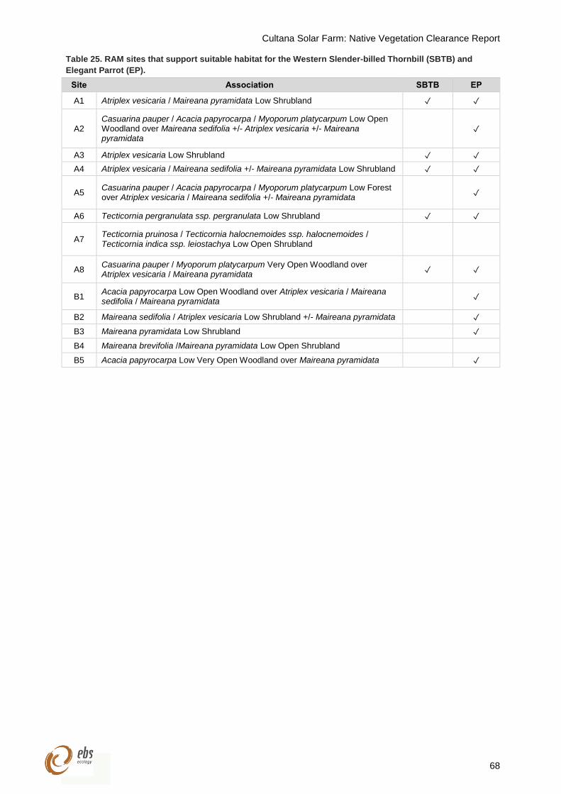
Cultana Solar Farm: Native Vegetation Clearance Report
68
Table 25. RAM sites that support suitable habitat for the Western Slender-billed Thornbill (SBTB) and
Elegant Parrot (EP).
Site Association SBTB EP
A1 Atriplex vesicaria / Maireana pyramidata Low Shrubland ✓ ✓
A2 Casuarina pauper / Acacia papyrocarpa / Myoporum platycarpum Low Open Woodland over Maireana sedifolia +/- Atriplex vesicaria +/- Maireana pyramidata
✓
A3 Atriplex vesicaria Low Shrubland ✓ ✓
A4 Atriplex vesicaria / Maireana sedifolia +/- Maireana pyramidata Low Shrubland ✓ ✓
A5 Casuarina pauper / Acacia papyrocarpa / Myoporum platycarpum Low Forest over Atriplex vesicaria / Maireana sedifolia +/- Maireana pyramidata
✓
A6 Tecticornia pergranulata ssp. pergranulata Low Shrubland ✓ ✓
A7 Tecticornia pruinosa / Tecticornia halocnemoides ssp. halocnemoides / Tecticornia indica ssp. leiostachya Low Open Shrubland
A8 Casuarina pauper / Myoporum platycarpum Very Open Woodland over Atriplex vesicaria / Maireana pyramidata
✓ ✓
B1 Acacia papyrocarpa Low Open Woodland over Atriplex vesicaria / Maireana sedifolia / Maireana pyramidata
✓
B2 Maireana sedifolia / Atriplex vesicaria Low Shrubland +/- Maireana pyramidata ✓
B3 Maireana pyramidata Low Shrubland ✓
B4 Maireana brevifolia /Maireana pyramidata Low Open Shrubland
B5 Acacia papyrocarpa Low Very Open Woodland over Maireana pyramidata ✓
Cultana Solar Farm: Native Vegetation Clearance Report
69
11 RECOMMENDATIONS
EBS recommends the following based on the desktop, vegetation and fauna assessments.
11.1 Legislative approvals
11.1.1 EPBC Act referral
It is recommended that if Western Grasswrens are detected within the Project area an EPBC Self-
Assessment should be conducted to determine whether a Significant Impact on the species attributed to
the Project could occur and subsequently whether an EPBC referral in required.
11.1.2 Native vegetation clearance
Native vegetation must not be cleared unless approval is granted by the NVC in accordance with Section
29 of the Native Vegetation Act 1991 or it is permitted under the Native Vegetation Regulations 2017. The
relevant Regulations require that clearance is undertaken in accordance with a Standard Operating
Procedure (SOP) or a Management Plan that has been approved by the NVC.
Once the Project is completed, the extent of vegetation removal can to be updated to determine if the SEB
offset was appropriate, or requires updating. The provision of an SEB can be undertaken in several forms
including managing and conserving areas of native vegetation, undertaking native vegetation restoration
activities or making a payment into the Native Vegetation Fund. Potential opportunities to achieve an SEB
offset within or surrounding the Project area should be identified.
11.2 Mitigation hierarchy
When exercising a power or making a decision under Division 5 of the Native Vegetation Regulations 2017,
the NVC must have regard to the proponent addressing the mitigation hierarchy. The NVC will assess the
measures taken to avoid and minimise impacts on biodiversity and rare or threatened species or ecological
communities within the property or immediate vicinity of the development.
11.2.1 Avoidance
Measures must be taken to avoid clearance of native vegetation such as making adjustments to the
location, design, size or scale of the activity in order to reduce the impact. It is recommended that woodland
areas and habitat for the Western Grasswren is avoided.
11.2.2 Minimisation
If clearance cannot be avoided, measures must be taken to minimise the extent, duration and intensity of
impacts of the clearance on biodiversity to the fullest possible extent.
It is recommended vehicles utilise existing tracks where possible and the number of new roads
should be kept to a minimum;
Access should be limited to a core number of designated tracks to minimise disturbance to flora
and fauna;

Cultana Solar Farm: Native Vegetation Clearance Report
70
Vehicles should stay on these tracks at all times to reduce impacts on vegetation and consequently
fauna habitat;
The construction footprint should be kept to a minimum for least impact on flora and fauna.
Management strategies for the construction phase of the Project need to be developed and
incorporated into an environmental management plan;
The Project should minimise situations that may assist the survival and /or proliferation of
introduced flora and fauna, i.e. keeping artificial water sources to a minimum and maintaining bores
and pipelines to ensure that they do not leak; and
Rubbish areas and any other potential food sources should be contained so that they are not
accessible to any introduced fauna.
11.2.3 Offset
Any adverse impact on native vegetation or ecosystems that cannot be avoided or minimised should be
offset by implementing a Significant Environmental Benefit that outweighs that impact (see above).
Biodiversity offsets address any residual impacts after prevention and mitigation measures have been
implemented.
The NVC will only approve clearances if these steps have been fulfilled. Offsetting is only considered by
the NVC when a proponent has identified and documented appropriate measures to avoid and minimise
negative impacts (direct or indirect) on biodiversity. Biodiversity offsets are only appropriate for projects
that have rigorously applied the Mitigation Hierarchy to the fullest extent. Offsets must never be used to
circumvent responsibilities to avoid and minimise damage to biodiversity and the NVC will consider this
when determining whether the clearance can proceed.
Cultana Solar Farm: Native Vegetation Clearance Report
71
12 REFERENCES
AECOM (2012) Draft. Fauna and fauna habitat existing conditions report. Prepared by AECOM for Arafura
Resources Limited. Adelaide, South Australia.
Atlas of Living Australia (ALA) (2018) Atlas of Living Australia. Available at http://www.ala.org.au.
[Accessed 10 July 2018].
Black A, Carpenter G, Pedler L (2009) Distribution and habitats of the Thick-billed Grasswren Amytornis
textilis, subspecies myall. South Australian Ornithologist 35.
Black A, Carpenter G, Pedler L (2011) Distribution and habitats of the Thick-billed Grasswren Amytornis
modestus and comparison with the Western Grasswren Amytornis textilis myall in South Australia.
South Australian Ornithologist 37.
Commonwealth of Australia. (2018) Bureau of Meteorology: Climate Data Online. Website at
http://www.bom.gov.au/climate/averages/tables/cw_018120_All.shtml [Accessed 10 July 2018].
Croft SJ, Milne TI, Pedler JA (2005-2009) Bushland Condition Monitoring Manual – Southern Mt Lofty
Ranges, Murray Darling Basin, Eyre Peninsula, Northern Agricultural & Yorke Peninsula regions.
Dennis TE, Detmar SA, Brooks AV, Dennis HM (2011) Distribution and status of White-bellied Sea-Eagle,
Haliaeetus leucogaster, and Eastern Osprey, Pandion cristatus, populations in South Australia.
South Australian Ornithologist 37, 1-16.
Department of Environment and Water (DEW) (2018a) Biological Database of South Australia data
extraction accessed 09/07/2018, Record set number DEWNRBDBSA180709-1.
Department of Environment and Water (DEW) (2018b) NatureMaps website at
https://data.environment.sa.gov.au/NatureMaps/Pages/default.aspx [Accessed 10 July 2018].
Department of the Environment (DotE) (2012) Interim Biogeographic Regionalisation for Australia v. 7
(IBRA) [ESRI shapefile]. Available at:
http://intspat01.ris.environment.gov.au/fed/catalog/search/resource/details.page?uuid=%7B3C18
2B5A-C081-4B56-82CA-DF5AF82F86DD%7D
Department of the Environment (DotE) (2018) Gallinago stenura in Species Profile and Threats Database,
Department of the Environment, Canberra.
Department of the Environment and Energy (DotEE) (2018) EPBC Act Protected Matters Report.
Commonwealth of Australia. Report created 04 July 2018.
Department of the Environment, Water, Heritage and the Arts (DEWHA) (2008) Approved Conservation
Advice for Frankenia plicata. Canberra: Department of the Environment, Water, Heritage and the
Arts.
EBS Ecology (2017) Whyalla Solar Farm – Baseline Ecological Report. Report to LBW. EBS Ecology,
Adelaide.
Huso M, Dietsch T, Nicolai C (2016) Mortality monitoring design for utility scale solar power facilities.
Prepared in cooperation with the U.S. Fish and Wildlife Service.
Cultana Solar Farm: Native Vegetation Clearance Report
72
Kutsche F, Lay B (2003) Field guide to plants of outback South Australia. Published by the Department of
water, Land and Biodiversity Conservation, South Australia.
Neagle N (2009) Provisional List of Threatened Ecosystems of South Australia – DEH in progress,
Department for Environment and Heritage (DEH), Government of South Australia.
Pizzey G, Knight F (2014) Birds of Australia. Gibbon Mutimedia Pty Ltd. Victoria, Australia.
Purnell C, Diyan MAA, Clemens R, Berry L, Oldland J (2009) Shorebird habitat mapping project: Gulf St
Vincent. Birds Australia report for the Adelaide and Mount Lofty Ranges Natural Resources
Management Board and the Department of the Environment, Water, Heritage and the Arts.
Reid JRW, Gillen JS (2013) Riparian bird assemblages of Cooper Creek, South Australia. Report by
Australian National University to the South Australian Arid Lands Natural Resource Management
Board, Port Augusta.
South Australian Seed Conservation Centre (SASCC) (2018a) Acacia rhigiophylla (Leguminosae) Dagger-
leaf Wattle. South Australia, Adelaide.
South Australian Seed Conservation Centre (SASCC) (2018b) Orobanche cernua var. australiana
(Orobanchaceae) Australian Broomrape. South Australia, Adelaide.
Threatened Species Scientific Committee (TSSC) (2016) Conservation advice Caladenia tensa rigid
spider-orchid. Canberra: Department of the Environment and Energy.
Threatened Species Scientific Committee (TSSC) (2013) Commonwealth listing advice on Acanthiza
iredalei iredalei (Slender-billed Thornbill (western)). Canberra: Department of the Environment.
Watkins D (1993) A national plan for shorebird conservation in Australia. Australasian Wader Studies
Group. RAOU Report No.90.
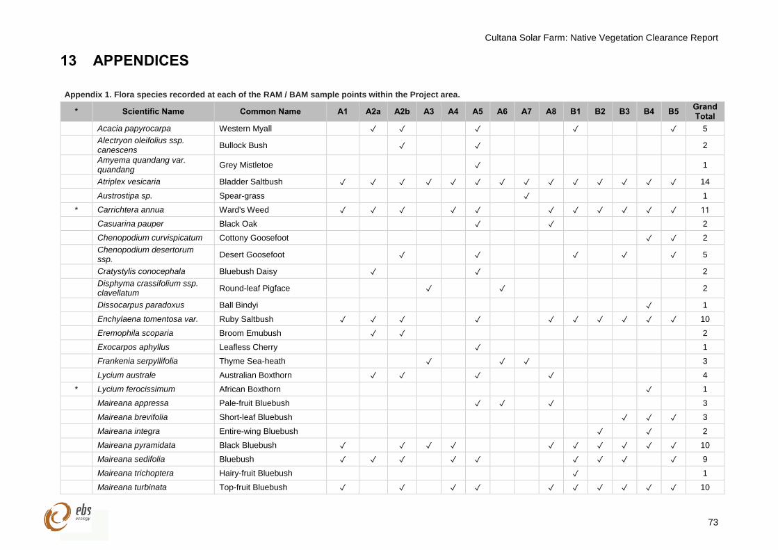
Cultana Solar Farm: Native Vegetation Clearance Report
73
13 APPENDICES
Appendix 1. Flora species recorded at each of the RAM / BAM sample points within the Project area.
* Scientific Name Common Name A1 A2a A2b A3 A4 A5 A6 A7 A8 B1 B2 B3 B4 B5 Grand Total
Acacia papyrocarpa Western Myall ✓ ✓ ✓ ✓ ✓ 5
Alectryon oleifolius ssp. canescens
Bullock Bush ✓ ✓ 2
Amyema quandang var. quandang
Grey Mistletoe ✓ 1
Atriplex vesicaria Bladder Saltbush ✓ ✓ ✓ ✓ ✓ ✓ ✓ ✓ ✓ ✓ ✓ ✓ ✓ ✓ 14
Austrostipa sp. Spear-grass ✓ 1
* Carrichtera annua Ward's Weed ✓ ✓ ✓ ✓ ✓ ✓ ✓ ✓ ✓ ✓ ✓ 11
Casuarina pauper Black Oak ✓ ✓ 2
Chenopodium curvispicatum Cottony Goosefoot ✓ ✓ 2
Chenopodium desertorum ssp.
Desert Goosefoot ✓ ✓ ✓ ✓ ✓ 5
Cratystylis conocephala Bluebush Daisy ✓ ✓ 2
Disphyma crassifolium ssp. clavellatum
Round-leaf Pigface ✓ ✓ 2
Dissocarpus paradoxus Ball Bindyi ✓ 1
Enchylaena tomentosa var. Ruby Saltbush ✓ ✓ ✓ ✓ ✓ ✓ ✓ ✓ ✓ ✓ 10
Eremophila scoparia Broom Emubush ✓ ✓ 2
Exocarpos aphyllus Leafless Cherry ✓ 1
Frankenia serpyllifolia Thyme Sea-heath ✓ ✓ ✓ 3
Lycium australe Australian Boxthorn ✓ ✓ ✓ ✓ 4
* Lycium ferocissimum African Boxthorn ✓ 1
Maireana appressa Pale-fruit Bluebush ✓ ✓ ✓ 3
Maireana brevifolia Short-leaf Bluebush ✓ ✓ ✓ 3
Maireana integra Entire-wing Bluebush ✓ ✓ 2
Maireana pyramidata Black Bluebush ✓ ✓ ✓ ✓ ✓ ✓ ✓ ✓ ✓ ✓ 10
Maireana sedifolia Bluebush ✓ ✓ ✓ ✓ ✓ ✓ ✓ ✓ ✓ 9
Maireana trichoptera Hairy-fruit Bluebush ✓ 1
Maireana turbinata Top-fruit Bluebush ✓ ✓ ✓ ✓ ✓ ✓ ✓ ✓ ✓ ✓ 10
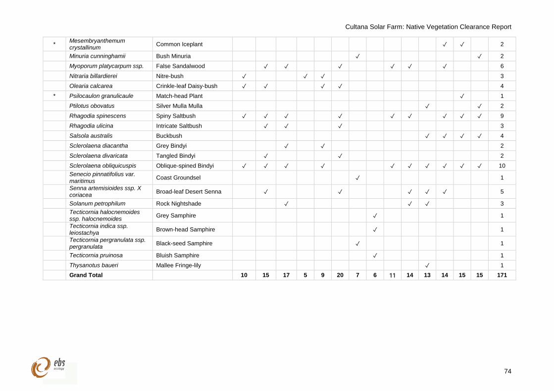
Cultana Solar Farm: Native Vegetation Clearance Report
74
* Mesembryanthemum crystallinum
Common Iceplant ✓ ✓ 2
Minuria cunninghamii Bush Minuria ✓ ✓ 2
Myoporum platycarpum ssp. False Sandalwood ✓ ✓ ✓ ✓ ✓ ✓ 6
Nitraria billardierei Nitre-bush ✓ ✓ ✓ 3
Olearia calcarea Crinkle-leaf Daisy-bush ✓ ✓ ✓ ✓ 4
* Psilocaulon granulicaule Match-head Plant ✓ 1
Ptilotus obovatus Silver Mulla Mulla ✓ ✓ 2
Rhagodia spinescens Spiny Saltbush ✓ ✓ ✓ ✓ ✓ ✓ ✓ ✓ ✓ 9
Rhagodia ulicina Intricate Saltbush ✓ ✓ ✓ 3
Salsola australis Buckbush ✓ ✓ ✓ ✓ 4
Sclerolaena diacantha Grey Bindyi ✓ ✓ 2
Sclerolaena divaricata Tangled Bindyi ✓ ✓ 2
Sclerolaena obliquicuspis Oblique-spined Bindyi ✓ ✓ ✓ ✓ ✓ ✓ ✓ ✓ ✓ ✓ 10
Senecio pinnatifolius var. maritimus
Coast Groundsel ✓ 1
Senna artemisioides ssp. X coriacea
Broad-leaf Desert Senna ✓ ✓ ✓ ✓ ✓ 5
Solanum petrophilum Rock Nightshade ✓ ✓ ✓ 3
Tecticornia halocnemoides ssp. halocnemoides
Grey Samphire ✓ 1
Tecticornia indica ssp. leiostachya
Brown-head Samphire ✓ 1
Tecticornia pergranulata ssp. pergranulata
Black-seed Samphire ✓ 1
Tecticornia pruinosa Bluish Samphire ✓ 1
Thysanotus baueri Mallee Fringe-lily ✓ 1
Grand Total 10 15 17 5 9 20 7 6 11 14 13 14 15 15 171
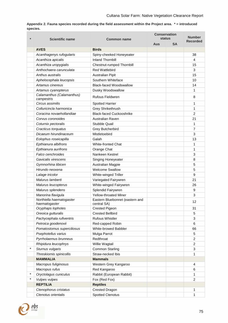
Cultana Solar Farm: Native Vegetation Clearance Report
75
Appendix 2. Fauna species recorded during the field assessment within the Project area. * = introduced
species.
* Scientific name Common name
Conservation status Number
Recorded Aus SA
AVES Birds
Acanthagenys rufogularis Spiny-cheeked Honeyeater 38
Acanthiza apicalis Inland Thornbill 4
Acanthiza uropygialis Chestnut-rumped Thornbill 15
Anthochaera carunculata Red Wattlebird 3
Anthus australis Australian Pipit 15
Aphelocephala leucopsis Southern Whiteface 10
Artamus cinereus Black-faced Woodswallow 14
Artamus cyanopterus Dusky Woodswallow 1
Calamanthus (Calamanthus) campestris
Rufous Fieldwren 8
Circus assimilis Spotted Harrier 1
Colluricincla harmonica Grey Shrikethrush 1
Coracina novaehollandiae Black-faced Cuckooshrike 2
Corvus coronoides Australian Raven 21
Coturnix pectoralis Stubble Quail 1
Cracticus torquatus Grey Butcherbird 7
Dicaeum hirundinaceum Mistletoebird 3
Eolophus roseicapilla Galah 13
Epthianura albifrons White-fronted Chat 1
Epthianura aurifrons Orange Chat 1
Falco cenchroides Nankeen Kestrel 3
Gavicalis virescens Singing Honeyeater 8
Gymnorhina tibicen Australian Magpie 5
Hirundo neoxena Welcome Swallow 5
Lalage tricolor White-winged Triller 9
Malurus lamberti Variegated Fairywren 21
Malurus leucopterus White-winged Fairywren 26
Malurus splendens Splendid Fairywren 9
Manorina flavigula Yellow-throated Miner 3
Northiella haematogaster haematogaster
Eastern Bluebonnet (eastern and central SA)
12
Ocyphaps lophotes Crested Pigeon 31
Oreoica gutturalis Crested Bellbird 5
Pachycephala rufiventris Rufous Whistler 3
Petroica goodenovii Red-capped Robin 6
Pomatostomus superciliosus White-browed Babbler 66
Psephotellus varius Mulga Parrot 5
Pyrrholaemus brunneus Redthroat 2
Rhipidura leucophrys Willie Wagtail 2
* Sturnus vulgaris Common Starling 3
Threskiornis spinicollis Straw-necked Ibis 1
MAMMALIA Mammals
Macropus fuliginosus Western Grey Kangaroo 4
Macropus rufus Red Kangaroo 6
* Oryctolagus cuniculus Rabbit (European Rabbit) 1
* Vulpes vulpes Fox (Red Fox) 2
REPTILIA Reptiles
Ctenophorus cristatus Crested Dragon 1
Ctenotus orientalis Spotted Ctenotus 1

Cultana Solar Farm: Native Vegetation Clearance Report
76
* Scientific name Common name
Conservation status Number
Recorded Aus SA
Demansia psammophis Yellow-faced Whipsnake 1
Pogona vitticeps Central Bearded Dragon 3
Tiliqua rugosa Sleepy Lizard 6
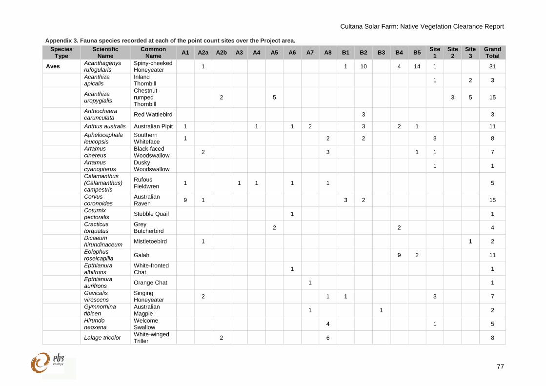
Cultana Solar Farm: Native Vegetation Clearance Report
77
Appendix 3. Fauna species recorded at each of the point count sites over the Project area.
Species Type
Scientific Name
Common Name
A1 A2a A2b A3 A4 A5 A6 A7 A8 B1 B2 B3 B4 B5 Site
1 Site
2 Site
3 Grand Total
Aves Acanthagenys rufogularis
Spiny-cheeked Honeyeater
1 1 10 4 14 1 31
Acanthiza apicalis
Inland Thornbill
1 2 3
Acanthiza uropygialis
Chestnut-rumped Thornbill
2 5 3 5 15
Anthochaera carunculata
Red Wattlebird 3 3
Anthus australis Australian Pipit 1 1 1 2 3 2 1 11
Aphelocephala leucopsis
Southern Whiteface
1 2 2 3 8
Artamus cinereus
Black-faced Woodswallow
2 3 1 1 7
Artamus cyanopterus
Dusky Woodswallow
1 1
Calamanthus (Calamanthus) campestris
Rufous Fieldwren
1 1 1 1 1 5
Corvus coronoides
Australian Raven
9 1 3 2 15
Coturnix pectoralis
Stubble Quail 1 1
Cracticus torquatus
Grey Butcherbird
2 2 4
Dicaeum hirundinaceum
Mistletoebird 1 1 2
Eolophus roseicapilla
Galah 9 2 11
Epthianura albifrons
White-fronted Chat
1 1
Epthianura aurifrons
Orange Chat 1 1
Gavicalis virescens
Singing Honeyeater
2 1 1 3 7
Gymnorhina tibicen
Australian Magpie
1 1 2
Hirundo neoxena
Welcome Swallow
4 1 5
Lalage tricolor White-winged Triller
2 6 8
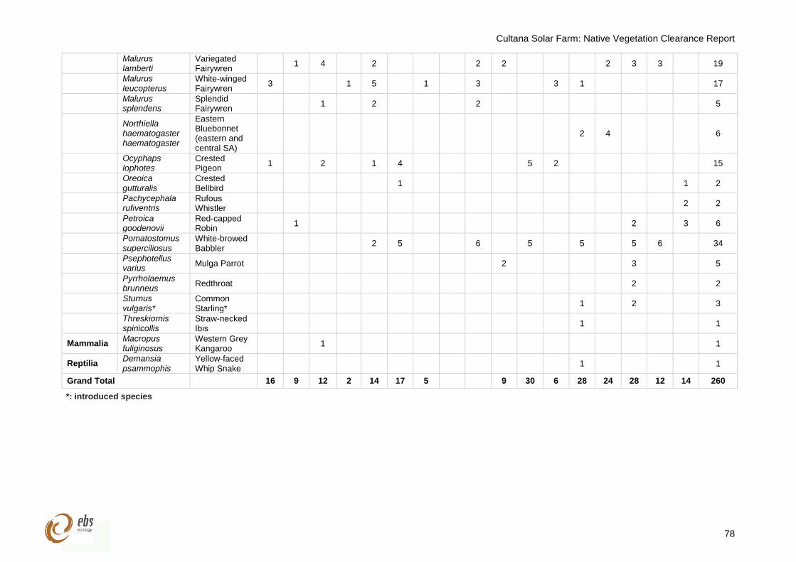
Cultana Solar Farm: Native Vegetation Clearance Report
78
Malurus lamberti
Variegated Fairywren
1 4 2 2 2 2 3 3 19
Malurus leucopterus
White-winged Fairywren
3 1 5 1 3 3 1 17
Malurus splendens
Splendid Fairywren
1 2 2 5
Northiella haematogaster haematogaster
Eastern Bluebonnet (eastern and central SA)
2 4 6
Ocyphaps lophotes
Crested Pigeon
1 2 1 4 5 2 15
Oreoica gutturalis
Crested Bellbird
1 1 2
Pachycephala rufiventris
Rufous Whistler
2 2
Petroica goodenovii
Red-capped Robin
1 2 3 6
Pomatostomus superciliosus
White-browed Babbler
2 5 6 5 5 5 6 34
Psephotellus varius
Mulga Parrot 2 3 5
Pyrrholaemus brunneus
Redthroat 2 2
Sturnus vulgaris*
Common Starling*
1 2 3
Threskiornis spinicollis
Straw-necked Ibis
1 1
Mammalia Macropus fuliginosus
Western Grey Kangaroo
1 1
Reptilia Demansia psammophis
Yellow-faced Whip Snake
1 1
Grand Total 16 9 12 2 14 17 5 9 30 6 28 24 28 12 14 260
*: introduced species
Cultana Solar Farm: Native Vegetation Clearance Report
EBS Ecology 125 Hayward Avenue Torrensville, SA 5031 www.ebsecology.com.au t. 08 7127 5607