Embed Size (px)
Citation preview
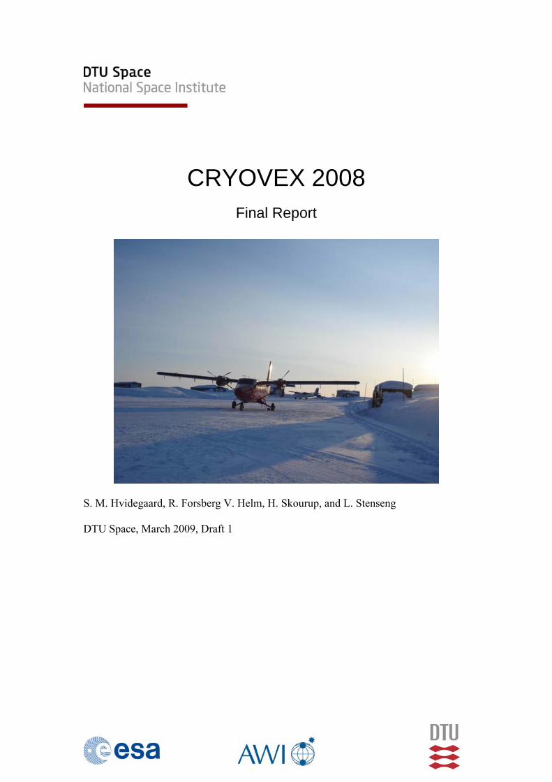
CRYOVEX 2008
Final Report
S. M. Hvidegaard, R. Forsberg V. Helm, H. Skourup, and L. Stenseng DTU Space, March 2009, Draft 1
CryoVEx 2008 - Final Report
2
Table of Contents Introduction....................................................................................................................3 1 Summary of operations ..........................................................................................4 2 Hardware Installation.............................................................................................7 3 Acquired data .......................................................................................................10 4 Processing ............................................................................................................11
4.1 GPS data processing ....................................................................................11 4.2 INS and GPS data merging ..........................................................................12 4.3 Laser scanner data processing......................................................................13 4.4 ASIRAS radar data processing ....................................................................20 4.5 Auxilary data................................................................................................21
5 Validation Sites....................................................................................................23 5.1 Northern Greenland Ice Sheet - UK1...........................................................23 5.2 Alert Sea Ice.................................................................................................24 5.3 Devon Ice Cap..............................................................................................26 5.4 Others: Ilulissat and Fram Strait ..................................................................27
6 Conclusions..........................................................................................................30 7 References............................................................................................................31 8 Appendix..............................................................................................................32
8.1 Operator logs................................................................................................32 8.2 File formats ..................................................................................................50 8.3 GPS reference coordinates...........................................................................53 8.4 Corner reflector details from sea ice in-situ observations ...........................53 8.5 ASIRAS data files........................................................................................54 8.6 Processed ASIRAS profiles .........................................................................62
CryoVEx 2008 - Final Report
3
Introduction The European Space Agency (ESA) CryoSat Validation Experiment, CryoVEx 2008 was carried out in April and May 2008. The airborne operations were coordinated by the National Space Institute, Danish Technical University (DTU Space) and took place in the period April 15 to May 8. The work consisted of:
• Airborne data collection with ASIRAS and laser scanner system. The operations were coordinated with ground and helicopter activities over land and sea ice in Greenland and Canada.
• Logistical support for participants in the CryoVEx 2008 experiment especially concerning transport and access to military facilities in Canadian Forces Station Alert and Thule Air Base as well as aircraft support to the UK team on the north Greenland ice sheet.
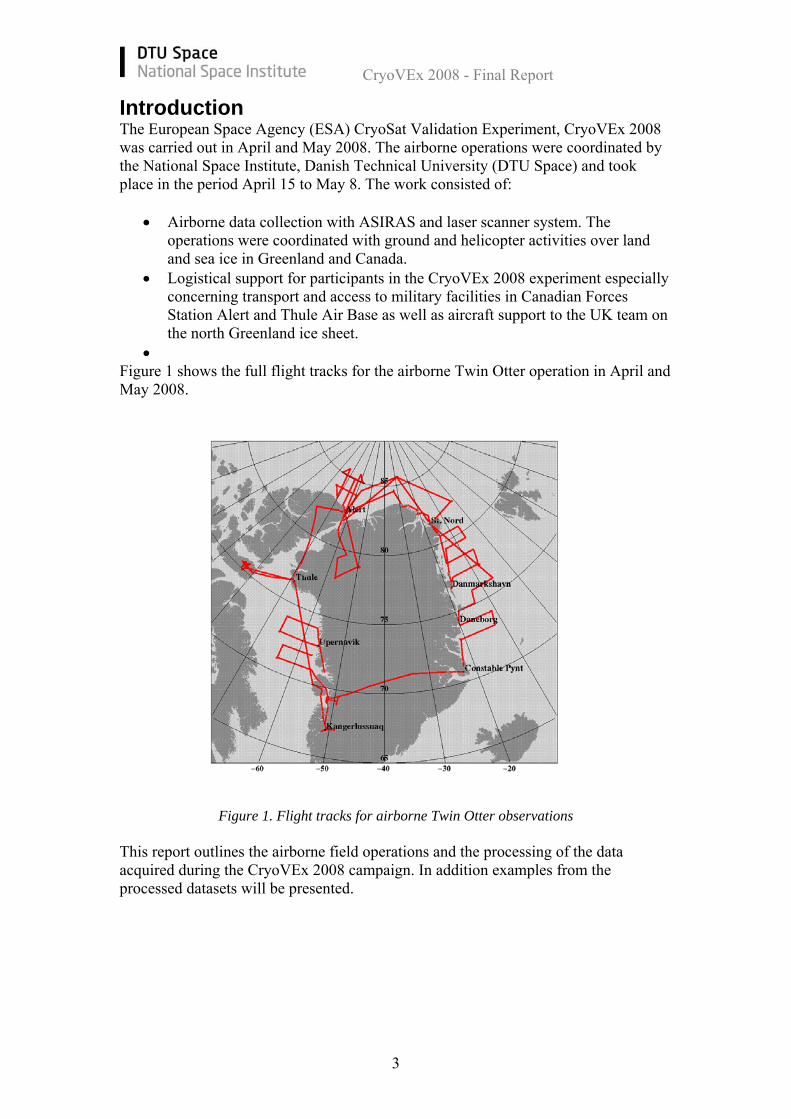
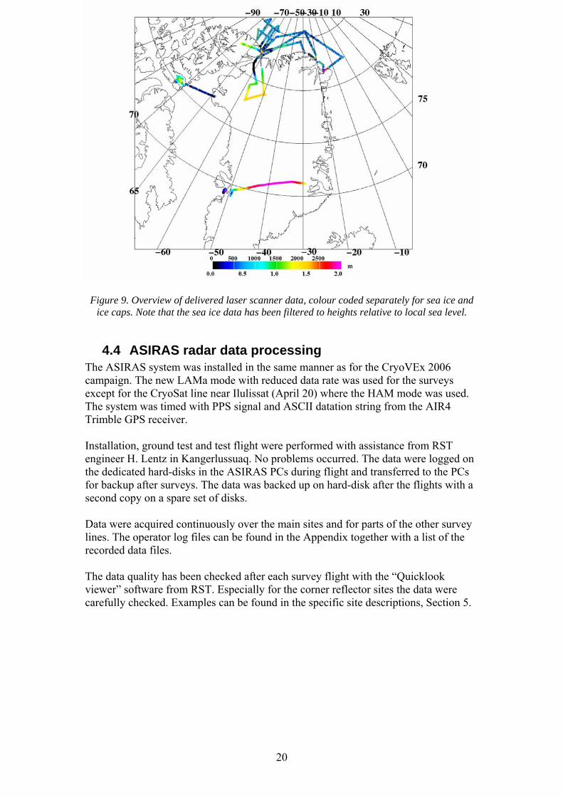
• Figure 1 shows the full flight tracks for the airborne Twin Otter operation in April and May 2008.
Figure 1. Flight tracks for airborne Twin Otter observations
This report outlines the airborne field operations and the processing of the data acquired during the CryoVEx 2008 campaign. In addition examples from the processed datasets will be presented.
CryoVEx 2008 - Final Report
4
1 Summary of operations The DTU Space operations started out on April 15 in Kangerlussuaq, Greenland, with installation of the laser scanner and ASIRAS system in the Air Greenland Twin Otter reg. OY-POF following the same procedures as certified in 2006. Due to a minor technical problem with the Twin Otter the aircraft was not available until the 16th. This did not affect the installation since the first day was spent on retrieving the cargo with the equipment and unpacking the boxes. Assistance with the ASIRAS system was provided by Raumfahrt Systemtechnik’s engineer. After installing the equipment in the Air Greenland hanger and performing ground tests, a successful test flight was carried out on April 17th. Apart from minor problems with the backup system for the laser measurements – INS and laser altimeter – the full system of laser scanner and ASIRAS was working as expected. The problems with the backup system were sorted out on ground prior to the next flights. The next two days were spent on a survey for the Bureau of Minerals and Petroleum, BMP, Greenland Homerule Government, monitoring the sea ice off the Greenland west coast near Upernavik. After this the EGIG line was surveyed April 20th on transit from Ilulissat to Constable Pynt on the east coast. En route, observations on a line near Ilulissat, both High Altitude and Low Altitude ASIRAS data were gathered. Next the Twin Otter continued to St. Nord, northeast Greenland, where again observation was carried out for the BMP. On April 26th a coordinated flight was carried out near KV Svalbard, the coast guard vessel from Svalbard, which was on a scientific cruise in the Fram Strait. The ship was anchored to an ice floe that was surveyed with the airborne system as well as on the surface from the ship in coordination with the Norwegian Polar Institute. From St. Nord a second survey was done on April 27th in order to re-measure lines north of Greenland. On April 28th the aircraft continued to CFS Alert to meet the ground teams there, who flew in from Canada and Qaanaaq, North Greenland, with dedicated Twin Otter flights (chartered from Ken Borek) on April 28th and 30th. In the meantime the other Air Greenland Twin Otter reg. OY-ATY equipped with skies deployed the UK1 team, of Liz Morris and Martin Hignell, on the ice sheet in northern Greenland via Qaanaaq and Thule Air Base. These operations were delayed by poor weather and took place from April 23rd to 25th and consisted of transport from Kangerlussuaq to Qaanaaq on April 23rd and put in on the ice over the next two days including deployment of two depots with fuel and other supplies for the transect. From Alert lines were surveyed in the Arctic Ocean on May 1st and 2nd. In addition the validation sites near the coast were observed on May 1st and on May 2nd a coordinated line was flown with the helicopter-borne EM bird system from Alfred Wegener Institute/University of Alberta, Edmonton. A second coordinated helicopter and Twin Otter flight was cancelled in the last minute on May 5th due to poor visibility. The Twin Otter flew a few survey lines near the AUV (Autonomous Underwater Vehicle) camp just off the coast but this also had to be altered to a lower altitude due to low clouds. Afterwards, the aircraft-team continued to Thule Air Base via Grant Ice Cap and Mt. Oxford on Ellesmere Island to position the Twin Otter for operations over Devon Island. Initially it was planned to

CryoVEx 2008 - Final Report
5
use the small inuit settlement Grise Fiord as base for the Devon survey but the weather favoured operations out of the larger and better equipped airfield in Thule. The Devon ice cap was then surveyed on May 6th where the main lines N-S and E-W was flown repeatedly to ensure corner reflector hits and a few lines suggested by the Canadian team was also surveyed. After the Devon flight the Twin Otter returned to Kangerlussuaq on May 7th to be used for a test campaign for the DTU Space P-Sounder instrument. The ASIRAS system was un-mounted and returned to RST. Table 1 gives an overview of the specific flights in chronological order and below a short day-to-day description is found. Day2day April 15-17 Installation and test of ASIRAS and laser scanner system on Twin Otter April 18 Survey of icebergs near Ilulissat for DMI and local flight for Danish
Television reporters April 19 Sea ice observations coordinated with helicopter in-situ measurements
off the west coast near Upernavik April 20 Transit to the east coast with survey of CryoSat line near Ilulissat and
the EGIG line across the ice sheet April 21 Transit to St. Nord after cancellation of helicopter operations near the
east coast due to ice fog in survey area. Some observations with laser and ASIRAS en route with refuelling in Daneborg
April 22-23 No flights due to bad weather in St. Nord April 24 Over-flight of KV Svalbard in the Fram Strait and survey of E-W lines
between St. Nord and Danmarkshavn. Refueling in Danmarkshavn April 25-26 No flights due to bad weather in St. Nord April 27 Observation on lines north of Greenland April 28 Transit to Alert with survey of sea ice near the coast and parts of the
coast of northern Greenland April 29 Survey of the UK1 site on the northern ice sheet April 30 Dense fog at Alert – no flights May 1 Survey of long lines north-east and survey of validation sites near Alert
in the afternoon May 2 Survey of square north-west and coordinated flight of N-S line in the
afternoon May 3 Snow and dense fog – no flights May 4 Planned afternoon flight with helicopter but had to cancel due to bad
weather May 5 Planned coordinated helicopter flight cancelled due to low clouds.
Survey of AUV site altered to low altitude followed by survey of Grant Ice Cap, Ellesmere Island, en route to Thule
May 6 Devon ice cap survey May 7 Return to Kangerlussuaq with sea ice observations en route and survey
over Disko Island May 8- Un-mount ASIRAS and P-sounder test
CryoVEx 2008 - Final Report
6
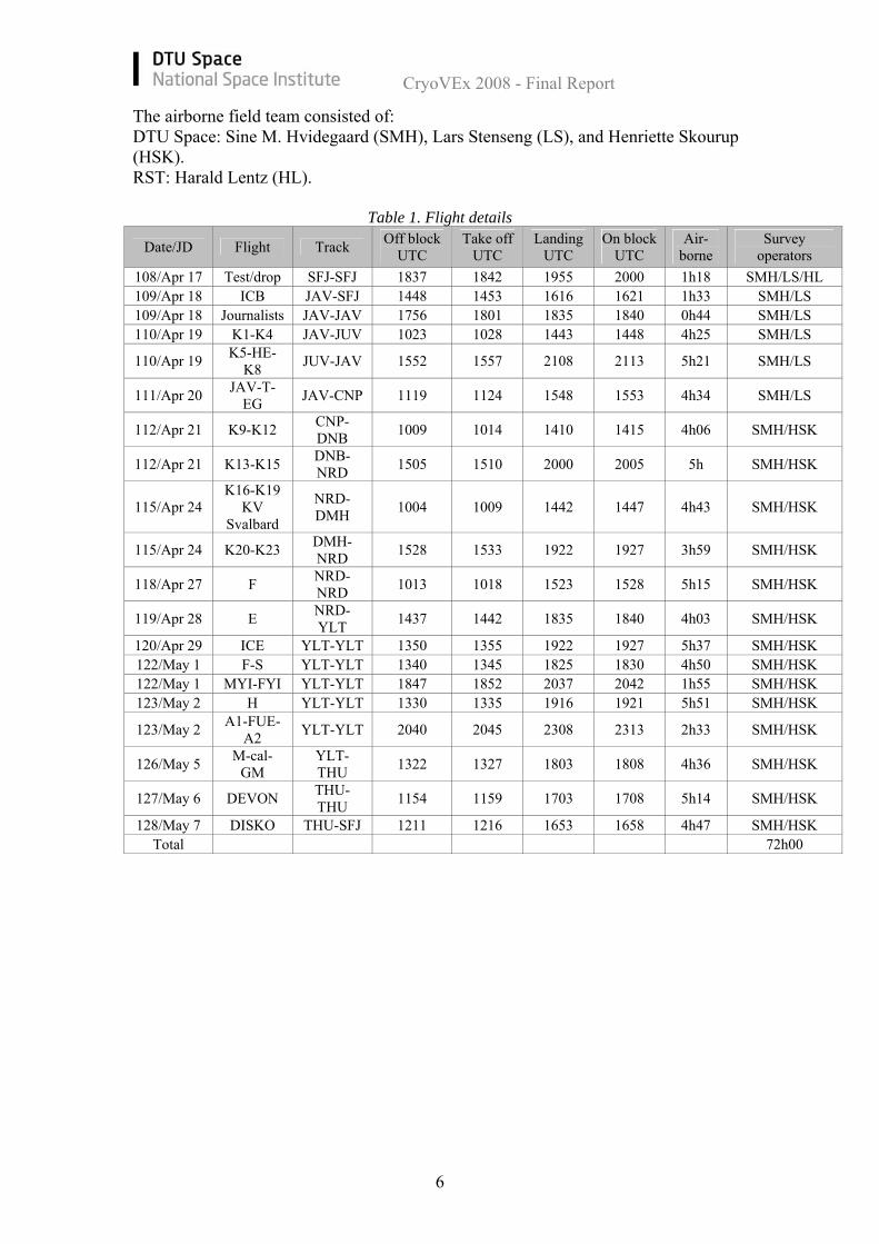
The airborne field team consisted of: DTU Space: Sine M. Hvidegaard (SMH), Lars Stenseng (LS), and Henriette Skourup (HSK). RST: Harald Lentz (HL).
Table 1. Flight details
Date/JD Flight Track Off block UTC
Take off UTC
Landing UTC
On block UTC
Air-borne
Survey operators
108/Apr 17 Test/drop SFJ-SFJ 1837 1842 1955 2000 1h18 SMH/LS/HL 109/Apr 18 ICB JAV-SFJ 1448 1453 1616 1621 1h33 SMH/LS 109/Apr 18 Journalists JAV-JAV 1756 1801 1835 1840 0h44 SMH/LS 110/Apr 19 K1-K4 JAV-JUV 1023 1028 1443 1448 4h25 SMH/LS
110/Apr 19 K5-HE-K8 JUV-JAV 1552 1557 2108 2113 5h21 SMH/LS
111/Apr 20 JAV-T-EG JAV-CNP 1119 1124 1548 1553 4h34 SMH/LS
112/Apr 21 K9-K12 CNP-DNB 1009 1014 1410 1415 4h06 SMH/HSK
112/Apr 21 K13-K15 DNB-NRD 1505 1510 2000 2005 5h SMH/HSK
115/Apr 24 K16-K19
KV Svalbard
NRD-DMH 1004 1009 1442 1447 4h43 SMH/HSK
115/Apr 24 K20-K23 DMH-NRD 1528 1533 1922 1927 3h59 SMH/HSK
118/Apr 27 F NRD-NRD 1013 1018 1523 1528 5h15 SMH/HSK
119/Apr 28 E NRD-YLT 1437 1442 1835 1840 4h03 SMH/HSK
120/Apr 29 ICE YLT-YLT 1350 1355 1922 1927 5h37 SMH/HSK 122/May 1 F-S YLT-YLT 1340 1345 1825 1830 4h50 SMH/HSK 122/May 1 MYI-FYI YLT-YLT 1847 1852 2037 2042 1h55 SMH/HSK 123/May 2 H YLT-YLT 1330 1335 1916 1921 5h51 SMH/HSK
123/May 2 A1-FUE-A2 YLT-YLT 2040 2045 2308 2313 2h33 SMH/HSK
126/May 5 M-cal-GM
YLT-THU 1322 1327 1803 1808 4h36 SMH/HSK
127/May 6 DEVON THU-THU 1154 1159 1703 1708 5h14 SMH/HSK
128/May 7 DISKO THU-SFJ 1211 1216 1653 1658 4h47 SMH/HSK Total 72h00
CryoVEx 2008 - Final Report
7
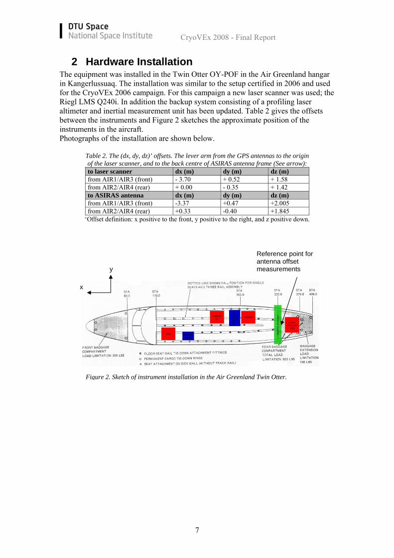
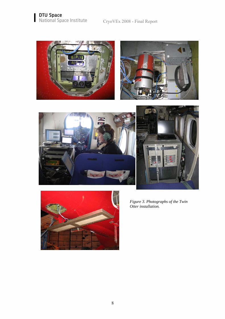
2 Hardware Installation The equipment was installed in the Twin Otter OY-POF in the Air Greenland hangar in Kangerlussuaq. The installation was similar to the setup certified in 2006 and used for the CryoVEx 2006 campaign. For this campaign a new laser scanner was used; the Riegl LMS Q240i. In addition the backup system consisting of a profiling laser altimeter and inertial measurement unit has been updated. Table 2 gives the offsets between the instruments and Figure 2 sketches the approximate position of the instruments in the aircraft. Photographs of the installation are shown below.
Table 2. The (dx, dy, dz)’ offsets. The lever arm from the GPS antennas to the origin of the laser scanner, and to the back centre of ASIRAS antenna frame (See arrow): to laser scanner dx (m) dy (m) dz (m) from AIR1/AIR3 (front) - 3.70 + 0.52 + 1.58 from AIR2/AIR4 (rear) + 0.00 - 0.35 + 1.42 to ASIRAS antenna dx (m) dy (m) dz (m) from AIR1/AIR3 (front) -3.37 +0.47 +2.005 from AIR2/AIR4 (rear) +0.33 -0.40 +1.845
‘Offset definition: x positive to the front, y positive to the right, and z positive down.
Reference point for antenna offset measurements
Figure 2. Sketch of instrument installation in the Air Greenland Twin Otter.
y
x
CryoVEx 2008 - Final Report
8
Figure 3. Photographs of the Twin Otter installation.
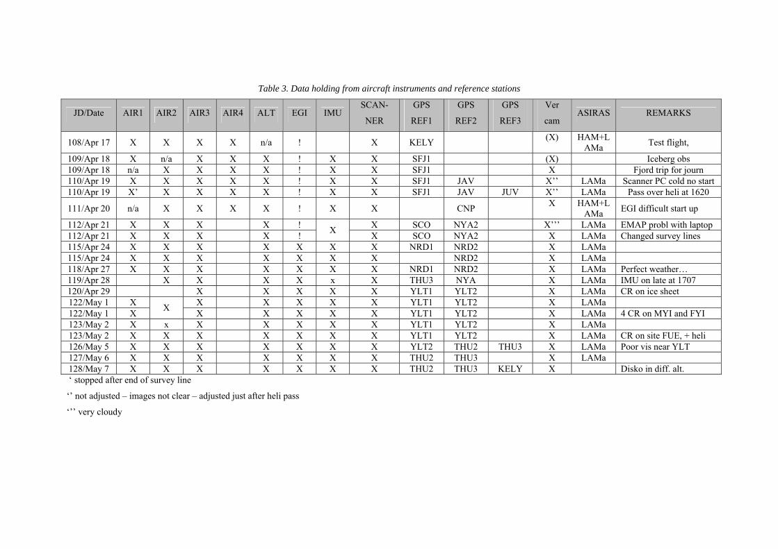
Table 3. Data holding from aircraft instruments and reference stations
JD/Date AIR1 AIR2 AIR3 AIR4 ALT EGI IMU SCAN-
NER
GPS
REF1
GPS
REF2
GPS
REF3
Ver
cam ASIRAS REMARKS
108/Apr 17 X X X X n/a ! X KELY (X) HAM+LAMa Test flight,
109/Apr 18 X n/a X X X ! X X SFJ1 (X) Iceberg obs 109/Apr 18 n/a X X X X ! X X SFJ1 X Fjord trip for journ 110/Apr 19 X X X X X ! X X SFJ1 JAV X’’ LAMa Scanner PC cold no start 110/Apr 19 X’ X X X X ! X X SFJ1 JAV JUV X’’ LAMa Pass over heli at 1620
111/Apr 20 n/a X X X X ! X X CNP X HAM+LAMa EGI difficult start up
112/Apr 21 X X X X ! X SCO NYA2 X’’’ LAMa EMAP probl with laptop 112/Apr 21 X X X X ! X X SCO NYA2 X LAMa Changed survey lines 115/Apr 24 X X X X X X X NRD1 NRD2 X LAMa 115/Apr 24 X X X X X X X NRD2 X LAMa 118/Apr 27 X X X X X X X NRD1 NRD2 X LAMa Perfect weather… 119/Apr 28 X X X X x X THU3 NYA X LAMa IMU on late at 1707 120/Apr 29 X X X X X YLT1 YLT2 X LAMa CR on ice sheet 122/May 1 X X X X X X YLT1 YLT2 X LAMa 122/May 1 X X X X X X X YLT1 YLT2 X LAMa 4 CR on MYI and FYI 123/May 2 X x X X X X X YLT1 YLT2 X LAMa 123/May 2 X X X X X X X YLT1 YLT2 X LAMa CR on site FUE, + heli 126/May 5 X X X X X X X YLT2 THU2 THU3 X LAMa Poor vis near YLT 127/May 6 X X X X X X X THU2 THU3 X LAMa 128/May 7 X X X X X X X THU2 THU3 KELY X Disko in diff. alt. ‘ stopped after end of survey line
‘’ not adjusted – images not clear – adjusted just after heli pass
‘’’ very cloudy
3 Acquired data During the CryoVEx 2008 campaign DTU Space acquired approximately 50 hours of ASIRAS data and 70 hrs of laser scanner, GPS, INS, and downward looking photographs with the airborne system. After each flight data was stored on dedicated harddisks and backup copies were made. The harddisks with ASIRAS data was delivered to AWI for processing. The remaining data was uploaded to the DTU Space servers also for post-processing. An overview of the collected data can be seen in Table 3 and a more detailed description is found along with processing details in the following paragraphs. Nearly all data were recovered and stored except for at few cases of operator errors, one laser scanner file never started and a few incidents where the GPS receivers had a full memory, but no problems were encountered for the main validation sites. The full set of raw data is now stored at the DTU space server system (with tape backup) and copies are kept on dedicated harddisks.
CryoVEx 2008 - Final Report
11
4 Processing
4.1 GPS data processing Kinematic differential GPS is the key positioning method of the aircraft. GPS dual-frequency phase data were logged at 1 Hz using 1-2 ground base receivers at one or more reference sites, and 4 aircraft receivers; one of these dedicated to the ASIRAS system. The aircraft GPS receivers are named AIR1 (Trimble 4000-SSI), AIR2 (Ashtech Z-extreme), AIR3 (Javad, Lexon), and AIR4 (Trimble 4000-SSI, connected to ASIRAS). AIR1 and AIR2 share the front GPS antenna; AIR3 and AIR4 the rear antenna. Antenna offsets are given in Table 2. Data were logged in the receivers during flights and downloaded upon landing on laptop PCs. Most data were recovered and only a few files missing, see Table 3, but the redundancy of receivers meant that GPS data are available for all flights. The AIR4 receiver had a problem with the serial port and was not downloaded after April 20. The GPS base stations to be used as reference stations for differential post processing of the GPS data are listed in Table 4. The stations were mounted on roofs or tripods in the field near the landing sites; the reference points were generally not marked. In addition data from permanent GPS stations were used for data processing. GPS solutions are based on static processing of the reference stations and kinematic differential processing of the airborne data. In addition precise point positioning has been used for some of the solution where precise information of satellite clock and orbit errors are used along with information from permanent IGS stations. First the position of the reference station is determined using SCOUT (Scripps Coordinate Update Tool) service operated by SOPAC (Scripps Orbit and Permanent Array Center) (http://sopac.ucsd.edu). SCOUT calculates the reference positions in ITRF 2005 using data from three nearest permanent GPS stations with a position accuracy of about 2 cm even in the Arctic with long distance to permanent stations. The reference stations used during CryoVEx 2008 are listed in Table 4 and coordinates are found in Appendix 8.3. The kinematic differential GPS processing were performed with GPSurvey (version 2.35) using precise IGS orbits and the GOAD-Goodman tropospheric model. On each flight several solutions are made using different combinations of GPS reference stations and aircraft receivers. The best solution for each flight (see Table 6) is selected. For some of the flights GPSurvey showed to have problems delivering a stable solution and precise point positioning using the software Trip (X. Zhang 2006) gave a better solution and this was selected (*.kin in Table 6). The GPS solution are used for further processing of INS and laser scanner data and also delivered to ESA and AWI for ASIRAS processing in the dedicated format documented by R. Cullen (2006).

CryoVEx 2008 - Final Report
12
Table 4. CryoVEx 2008 GPS reference stations Name Location Hardware (antenna type)
SFJ1 Kangerlussuaq, on met hut roof Javad Maxor, (RegAnt) JAV0 On latter to roof, airport Javad Maxor (int. ant, LegAnt) JUV0 Upernavik near airport Javad Legacy (MarAnt) CNP0 On hotel roof Javad Legacy (RegAnt) NRD1 Station Nord, on snow next to apron Javad Maxor (int. ant) NRD2 Station Nord, on snow next to apron Javad Legacy (RegAnt) YLT1 On snow next to Spinnaker, small tripod Javad Maxor (int. ant) YLT2 Back side of Huricane, on stick Javad Legacy (RegAnt) THU2 Thule Air Base, permanent station Javad Legacy THU3 Thule Air Base, permanent station Ashtech Z-XII3 SCOR Scoresbysund, permanent station Ashtech UZ-12
4.2 INS and GPS data merging Similar to previous campaigns (e.g CryoVEx 2003, 04 and 06) a Honeywell medium grade inertial navigation system H764-G, EGI, was used throughout the surveys to record inertially integrated position, velocity and attitude information. Data were logged on a rack mounted PC with solid state hard-disks in binary format through a 1558 mil-spec communication bus. Data from all flights have been obtained. The data from April 17th to April 21st have not been initialised properly at the alignment but this will not affect the laser scanner processing as the files still contains the information needed about attitude changes. Recordings and comments can be found in Table 3. The position and attitude information is extracted from the INS data packets and averaged to 10 Hz. The averaging to 10 Hz has proven to be a good balance between file size and resolution in time. To obtain a higher resolution in the time domain and preserve precision the post processed GPS and INS data is merged by draping the INS derived positions onto the GPS positions. This draping is done by modelling the function, found in equation (1), by a low pass smoothed correction curve, which is added to the INS.
ε (t) = PGPS(t) – PINS(t) (1)
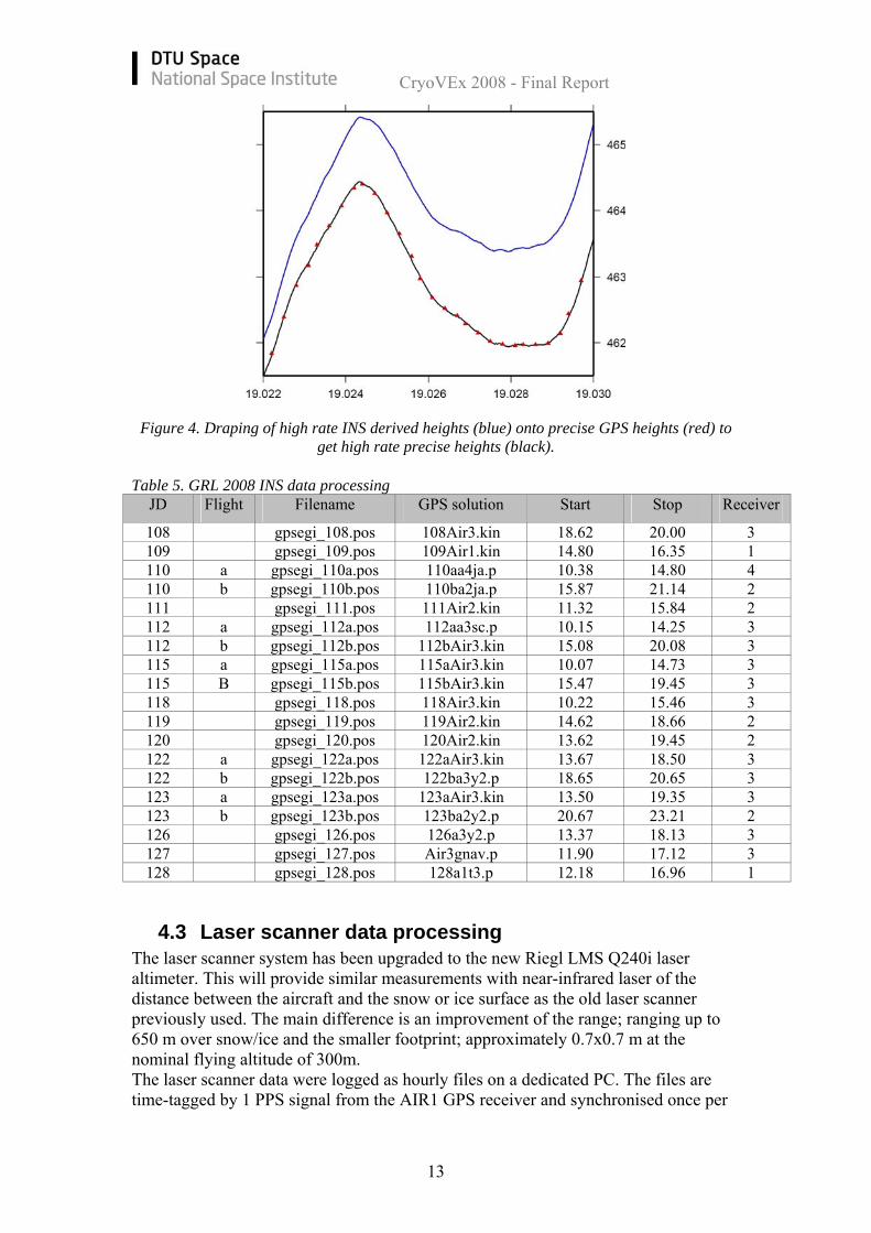
This way a smooth GPS-INS solution is obtained, which can be used for geolocation of laser and camera observation. The full resolution INS data were also converted into binary format as specified in the ESA document for the ASIRAS processing by R. Cullen (2006). Details about the INS processing is found in Table 5 and Figure 4 shows an example of the draping of high rate INS heights onto precise GPS heights.
CryoVEx 2008 - Final Report
13
Figure 4. Draping of high rate INS derived heights (blue) onto precise GPS heights (red) to
get high rate precise heights (black). Table 5. GRL 2008 INS data processing
JD Flight Filename GPS solution Start Stop Receiver
108 gpsegi_108.pos 108Air3.kin 18.62 20.00 3 109 gpsegi_109.pos 109Air1.kin 14.80 16.35 1 110 a gpsegi_110a.pos 110aa4ja.p 10.38 14.80 4 110 b gpsegi_110b.pos 110ba2ja.p 15.87 21.14 2 111 gpsegi_111.pos 111Air2.kin 11.32 15.84 2 112 a gpsegi_112a.pos 112aa3sc.p 10.15 14.25 3 112 b gpsegi_112b.pos 112bAir3.kin 15.08 20.08 3 115 a gpsegi_115a.pos 115aAir3.kin 10.07 14.73 3 115 B gpsegi_115b.pos 115bAir3.kin 15.47 19.45 3 118 gpsegi_118.pos 118Air3.kin 10.22 15.46 3 119 gpsegi_119.pos 119Air2.kin 14.62 18.66 2 120 gpsegi_120.pos 120Air2.kin 13.62 19.45 2 122 a gpsegi_122a.pos 122aAir3.kin 13.67 18.50 3 122 b gpsegi_122b.pos 122ba3y2.p 18.65 20.65 3 123 a gpsegi_123a.pos 123aAir3.kin 13.50 19.35 3 123 b gpsegi_123b.pos 123ba2y2.p 20.67 23.21 2 126 gpsegi_126.pos 126a3y2.p 13.37 18.13 3 127 gpsegi_127.pos Air3gnav.p 11.90 17.12 3 128 gpsegi_128.pos 128a1t3.p 12.18 16.96 1
4.3 Laser scanner data processing The laser scanner system has been upgraded to the new Riegl LMS Q240i laser altimeter. This will provide similar measurements with near-infrared laser of the distance between the aircraft and the snow or ice surface as the old laser scanner previously used. The main difference is an improvement of the range; ranging up to 650 m over snow/ice and the smaller footprint; approximately 0.7x0.7 m at the nominal flying altitude of 300m. The laser scanner data were logged as hourly files on a dedicated PC. The files are time-tagged by 1 PPS signal from the AIR1 GPS receiver and synchronised once per
CryoVEx 2008 - Final Report
14
flight by the operator and named with the start time. Table 6 shows the logged files with start /stop times. The data rate has been fixed to 250 observations per line and 40 lines per second throughout the campaign. The synchronisation of the data failed for part of the flights which means that the synchronisation has to be checked for each of these files during processing. This will not affect the data quality as it can be verified visually by plotting the results. Laser scanner data were recovered for most flights except minor parts with low clouds or fog. Some problems occurred with the laser scanner PC at start up of the system caused by the cold weather. This was solved by heating the PC or running it during night on external power.
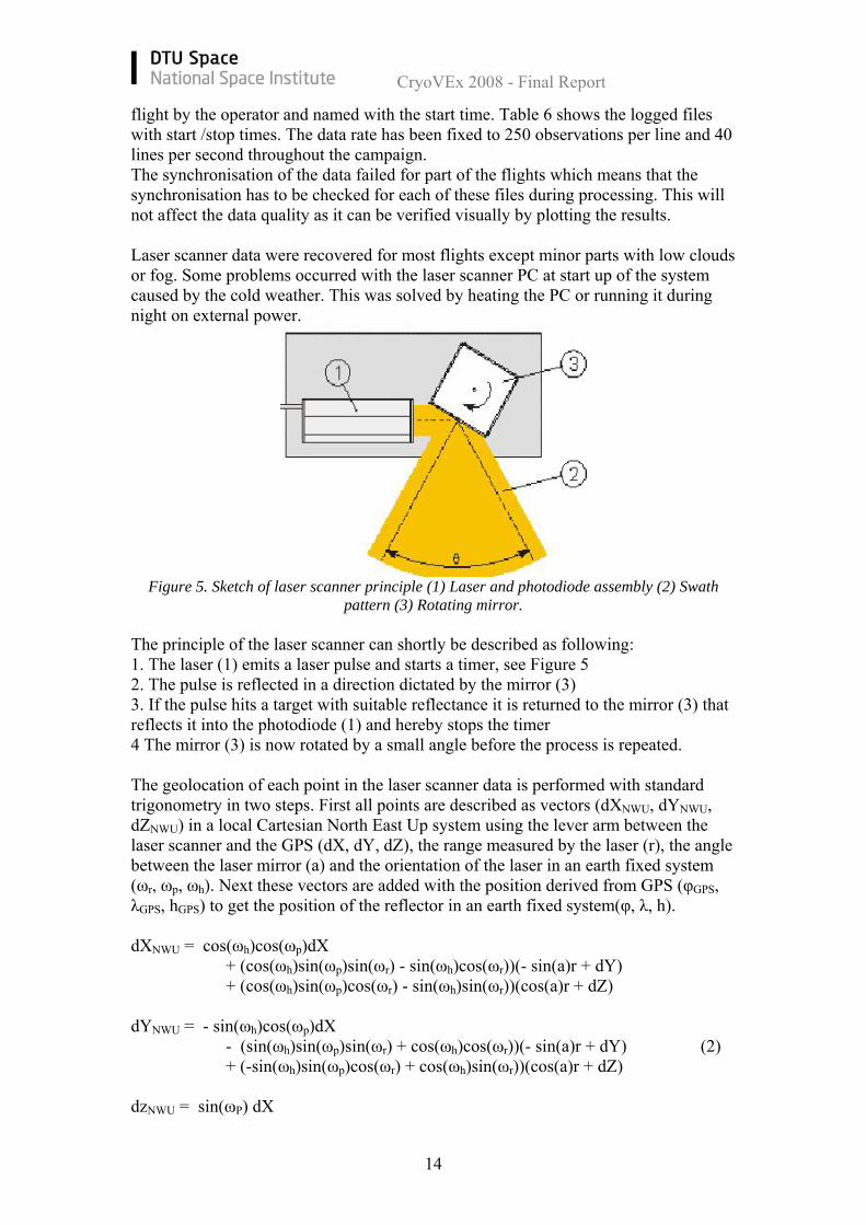
Figure 5. Sketch of laser scanner principle (1) Laser and photodiode assembly (2) Swath pattern (3) Rotating mirror.
The principle of the laser scanner can shortly be described as following: 1. The laser (1) emits a laser pulse and starts a timer, see Figure 5 2. The pulse is reflected in a direction dictated by the mirror (3) 3. If the pulse hits a target with suitable reflectance it is returned to the mirror (3) that reflects it into the photodiode (1) and hereby stops the timer 4 The mirror (3) is now rotated by a small angle before the process is repeated. The geolocation of each point in the laser scanner data is performed with standard trigonometry in two steps. First all points are described as vectors (dXNWU, dYNWU, dZNWU) in a local Cartesian North East Up system using the lever arm between the laser scanner and the GPS (dX, dY, dZ), the range measured by the laser (r), the angle between the laser mirror (a) and the orientation of the laser in an earth fixed system (ωr, ωp, ωh). Next these vectors are added with the position derived from GPS (φGPS, λGPS, hGPS) to get the position of the reflector in an earth fixed system(φ, λ, h). dXNWU = cos(ωh)cos(ωp)dX + (cos(ωh)sin(ωp)sin(ωr) - sin(ωh)cos(ωr))(- sin(a)r + dY) + (cos(ωh)sin(ωp)cos(ωr) - sin(ωh)sin(ωr))(cos(a)r + dZ) dYNWU = - sin(ωh)cos(ωp)dX - (sin(ωh)sin(ωp)sin(ωr) + cos(ωh)cos(ωr))(- sin(a)r + dY) (2) + (-sin(ωh)sin(ωp)cos(ωr) + cos(ωh)sin(ωr))(cos(a)r + dZ) dzNWU = sin(ωP) dX

CryoVEx 2008 - Final Report
15
- cos(ωp)sin(ωr)(- sin(a)r + dY) - cos(ωp)cos(ωr)(cos(a)r + dZ)
φ = φGPS + dXNWU /degm λ = λGPS + dYNWU /(degm cos(φ) (3) h = hGPS + dZNWU where degm is meter per degree. This geolocation process just described assumes perfect alignment between the laser scanner and the INS system, this is however not practically possible in this type of installation. To compensate for the imperfect installation several calibration manoeuvres are performed during the campaign. The purpose of these manoeuvres is to determine and monitor the offset angles between the laser scanner and the INS.
Figure 6. Laser scanner data from calibration site – building in Kangerlussuaq. Data from two passes overlaid displaying the match after calibration
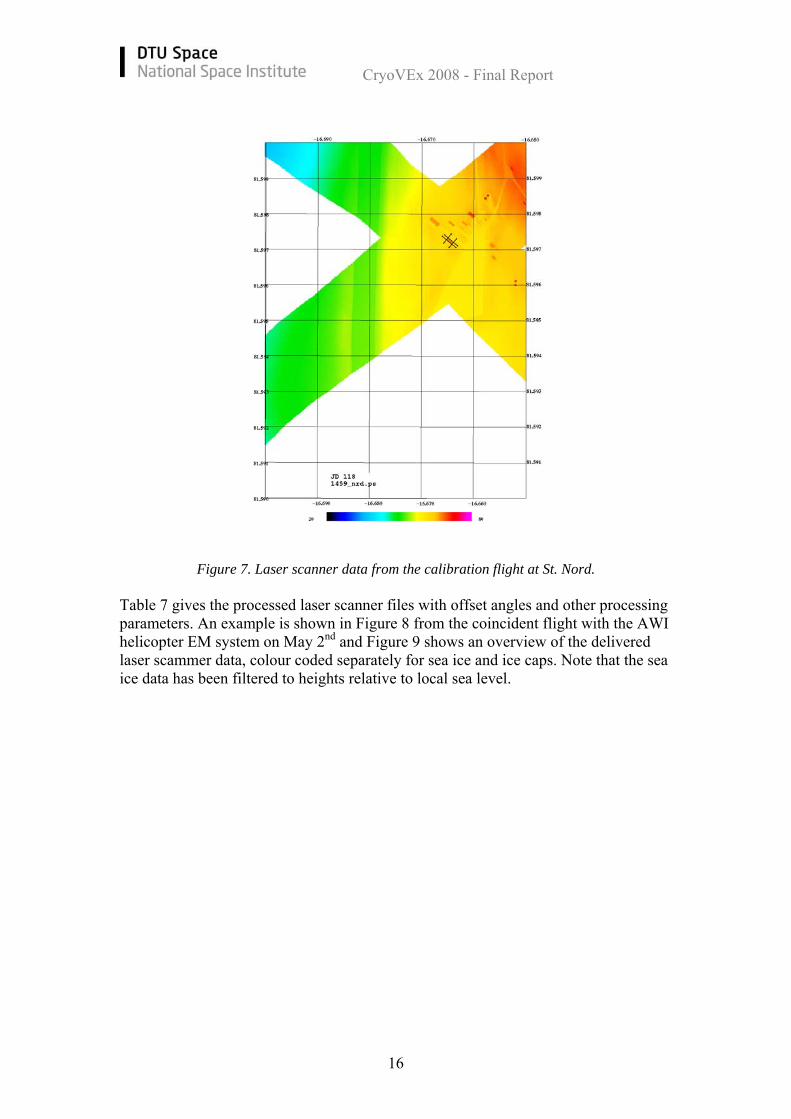
The main calibration site for the laser is a building where the corners of the roof are known from a GPS survey. Using this building and two swaths of laser scanner data, one east-west and one north-south, one can estimate the offset angles through an iterative process. In Figure 6 points from the two swaths (heights in colour-coding) are plotted on top of the black outline of the building. The calibration is monitored using similar methods over building (Station Nord and CFS Alert) and cross-overs during the surveys. Figure 7 shows the calibration flight at St. Nord on April 27.
CryoVEx 2008 - Final Report
16
Figure 7. Laser scanner data from the calibration flight at St. Nord.
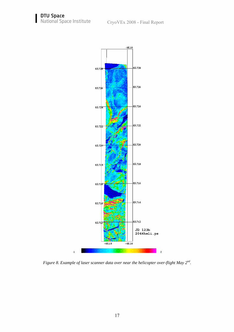
Table 7 gives the processed laser scanner files with offset angles and other processing parameters. An example is shown in Figure 8 from the coincident flight with the AWI helicopter EM system on May 2nd and Figure 9 shows an overview of the delivered laser scammer data, colour coded separately for sea ice and ice caps. Note that the sea ice data has been filtered to heights relative to local sea level.
CryoVEx 2008 - Final Report
17
Figure 8. Example of laser scanner data over near the helicopter over-flight May 2nd.
CryoVEx 2008 - Final Report
18
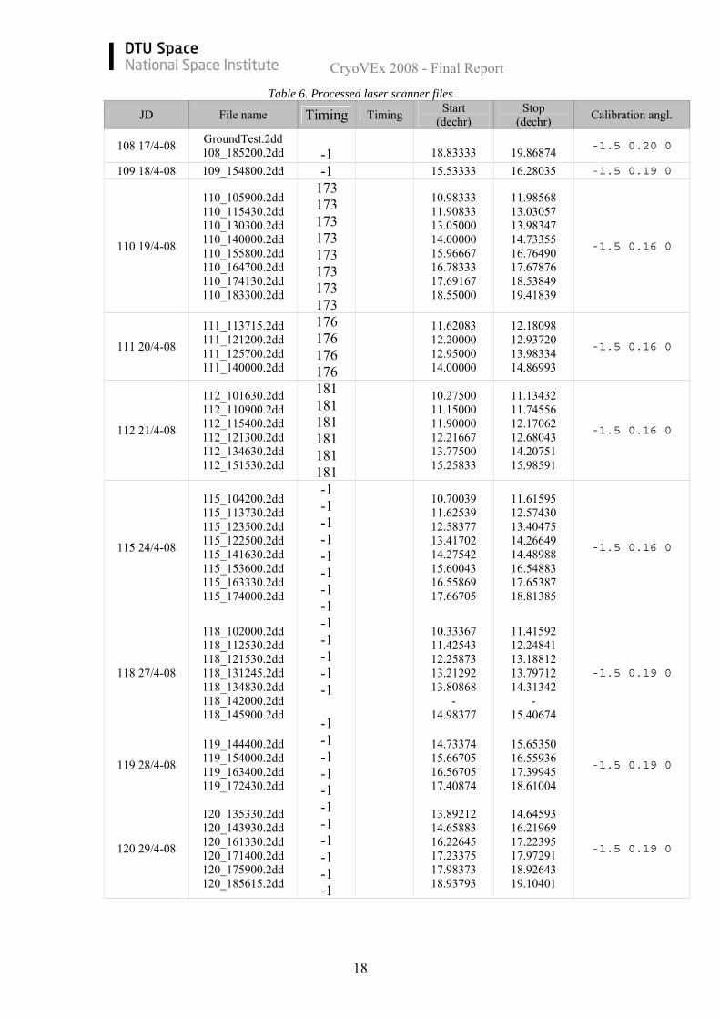
Table 6. Processed laser scanner files
JD File name Timing Timing Start (dechr)
Stop (dechr) Calibration angl.
108 17/4-08 GroundTest.2dd 108_185200.2dd
-1
18.83333
19.86874 -1.5 0.20 0
109 18/4-08 109_154800.2dd -1 15.53333 16.28035 -1.5 0.19 0
110 19/4-08
110_105900.2dd 110_115430.2dd 110_130300.2dd 110_140000.2dd 110_155800.2dd 110_164700.2dd 110_174130.2dd 110_183300.2dd
173 173 173 173 173 173 173 173
10.98333 11.90833 13.05000 14.00000 15.96667 16.78333 17.69167 18.55000
11.98568 13.03057 13.98347 14.73355 16.76490 17.67876 18.53849 19.41839
-1.5 0.16 0
111 20/4-08
111_113715.2dd 111_121200.2dd 111_125700.2dd 111_140000.2dd
176 176 176 176
11.62083 12.20000 12.95000 14.00000
12.18098 12.93720 13.98334 14.86993
-1.5 0.16 0
112 21/4-08
112_101630.2dd 112_110900.2dd 112_115400.2dd 112_121300.2dd 112_134630.2dd 112_151530.2dd
181 181 181 181 181 181
10.27500 11.15000 11.90000 12.21667 13.77500 15.25833
11.13432 11.74556 12.17062 12.68043 14.20751 15.98591
-1.5 0.16 0
115 24/4-08
115_104200.2dd 115_113730.2dd 115_123500.2dd 115_122500.2dd 115_141630.2dd 115_153600.2dd 115_163330.2dd 115_174000.2dd
-1 -1 -1 -1 -1 -1 -1 -1
10.70039 11.62539 12.58377 13.41702 14.27542 15.60043 16.55869 17.66705
11.61595 12.57430 13.40475 14.26649 14.48988 16.54883 17.65387 18.81385
-1.5 0.16 0
118 27/4-08
118_102000.2dd 118_112530.2dd 118_121530.2dd 118_131245.2dd 118_134830.2dd 118_142000.2dd 118_145900.2dd
-1 -1 -1 -1 -1
-1
10.33367 11.42543 12.25873 13.21292 13.80868
- 14.98377
11.41592 12.24841 13.18812 13.79712 14.31342
- 15.40674
-1.5 0.19 0
119 28/4-08
119_144400.2dd 119_154000.2dd 119_163400.2dd 119_172430.2dd
-1 -1 -1 -1
14.73374 15.66705 16.56705 17.40874
15.65350 16.55936 17.39945 18.61004
-1.5 0.19 0
120 29/4-08
120_135330.2dd 120_143930.2dd 120_161330.2dd 120_171400.2dd 120_175900.2dd 120_185615.2dd
-1 -1 -1 -1 -1 -1
13.89212 14.65883 16.22645 17.23375 17.98373 18.93793
14.64593 16.21969 17.22395 17.97291 18.92643 19.10401
-1.5 0.19 0

CryoVEx 2008 - Final Report
19
122 1/5-08
122_134000.2dd 122_143500.2dd 122_153330.2dd 122_162730.2dd 122_173000.2dd 122_184630.2dd 122_193645.2dd
-1 -1 -1 -1 -1 -1 -1
13.66705 14.58370 15.55870 16.45869 17.50040 18.77561 19.61290
14.57000 15.55050 16.45018 17.48911 18.22298 19.60370 20.62406
-1.5 0.19 0
123 2/5-08
123_133030.2dd 123_143100.2dd 123_151500.2dd 123_161500.2dd 123_172730.2dd 123_183830.2dd 123_204600.2dd 123_220030.2dd 123_230100.2dd
-1 -1 -1 -1 -1 -1 -1 -1 -1
13.50888 14.51708 15.25039 16.25038 17.45870 18.64210 20.76706 22.00874 23.02184
14.50900 15.24099 16.23944 17.44694 18.62964 19.29238 21.99410 22.86155 23.14300
-1.5 0.19 0
126 5/5-08 126_131800.2dd 126_143400.2dd 126_145930.2dd
-1 -1 -1
13.30041 14.56704 14.99203
14.55898 14.98449 15.49834
-1.5 0.19 0
127 6/5-08
127_120015.2dd 127_131200.2dd 127_133000.2dd 127_141600.2dd 127_150030.2dd
-1 -1 -1 -1 -1
12.00458 13.20036 13.50038 14.26708 15.00874
13.18491 13.49056 14.25457 14.99530 15.84995
-1.5 0.19 0
128 7/5-08
128_121800.2dd 128_124515.2dd 128_134200.2dd 128_142630.2dd 128_151100.2dd
-1 -1 -1 -1 -1
12.30033 12.75456 13.70036 14.44210 15.18378
12.74411 13.68720 14.42977 15.17147 15.90188
-1.5 0.19 0
CryoVEx 2008 - Final Report
20
Figure 9. Overview of delivered laser scanner data, colour coded separately for sea ice and
ice caps. Note that the sea ice data has been filtered to heights relative to local sea level.
4.4 ASIRAS radar data processing The ASIRAS system was installed in the same manner as for the CryoVEx 2006 campaign. The new LAMa mode with reduced data rate was used for the surveys except for the CryoSat line near Ilulissat (April 20) where the HAM mode was used. The system was timed with PPS signal and ASCII datation string from the AIR4 Trimble GPS receiver. Installation, ground test and test flight were performed with assistance from RST engineer H. Lentz in Kangerlussuaq. No problems occurred. The data were logged on the dedicated hard-disks in the ASIRAS PCs during flight and transferred to the PCs for backup after surveys. The data was backed up on hard-disk after the flights with a second copy on a spare set of disks. Data were acquired continuously over the main sites and for parts of the other survey lines. The operator log files can be found in the Appendix together with a list of the recorded data files. The data quality has been checked after each survey flight with the “Quicklook viewer” software from RST. Especially for the corner reflector sites the data were carefully checked. Examples can be found in the specific site descriptions, Section 5.
CryoVEx 2008 - Final Report
21
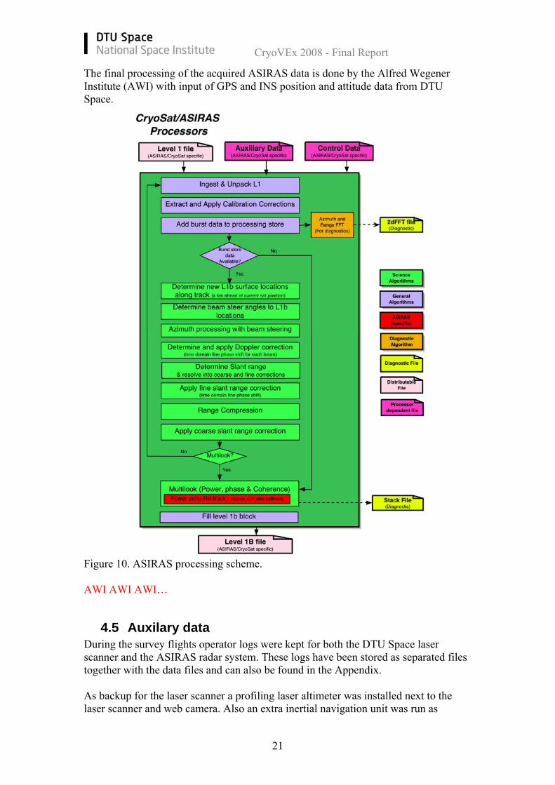
The final processing of the acquired ASIRAS data is done by the Alfred Wegener Institute (AWI) with input of GPS and INS position and attitude data from DTU Space.
Figure 10. ASIRAS processing scheme. AWI AWI AWI…
4.5 Auxilary data During the survey flights operator logs were kept for both the DTU Space laser scanner and the ASIRAS radar system. These logs have been stored as separated files together with the data files and can also be found in the Appendix. As backup for the laser scanner a profiling laser altimeter was installed next to the laser scanner and web camera. Also an extra inertial navigation unit was run as
CryoVEx 2008 - Final Report
22
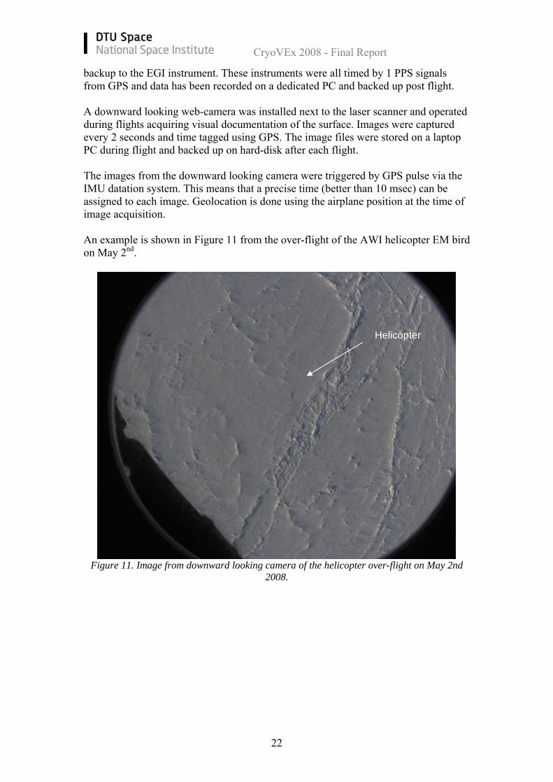
backup to the EGI instrument. These instruments were all timed by 1 PPS signals from GPS and data has been recorded on a dedicated PC and backed up post flight. A downward looking web-camera was installed next to the laser scanner and operated during flights acquiring visual documentation of the surface. Images were captured every 2 seconds and time tagged using GPS. The image files were stored on a laptop PC during flight and backed up on hard-disk after each flight. The images from the downward looking camera were triggered by GPS pulse via the IMU datation system. This means that a precise time (better than 10 msec) can be assigned to each image. Geolocation is done using the airplane position at the time of image acquisition. An example is shown in Figure 11 from the over-flight of the AWI helicopter EM bird on May 2nd.
Figure 11. Image from downward looking camera of the helicopter over-flight on May 2nd 2008.
Helicopter
CryoVEx 2008 - Final Report
23
5 Validation Sites One of the main goals of the CryoVEx 2008 campaign was to gather coincident laser scanner and ASIRAS data over specific validation sites with scientist doing in-situ observations on the surface. At these sites corner reflectors were raised and the positions are listed in Table 7. Table 7. CryoVEx 08 Corner Reflector Positions
Name Latitude (deg min sec) Longitude (deg min sec) Latitude Longitude
ICE2 79 0 0.919 N 50 0 26.959 W 79.0002555 -50.0074887 FYIE 82 32 46.572 N 62 34 50.880W 82.54627 -62.56808 FYIW 82 32 52.008 N 62 35 8.340W 82.54778 -62.58565 MYIS 82 33 22.824 N 62 33 33.696 W 82.55634 -62.55936 MYIN 82 33 36.540 N 62 33 43.308 W 82.56015 -62.56203 CAMP 82 33 3.6 N 62 34 30 W 82.551 -62.575
DEVON 75 20 17.124 N 82 40 38.604 W 75.33809 -82.67739 Note: Several more CR was placed along the lines on Devon Ice Cap
More details about each validation site are found in the next paragraphs.
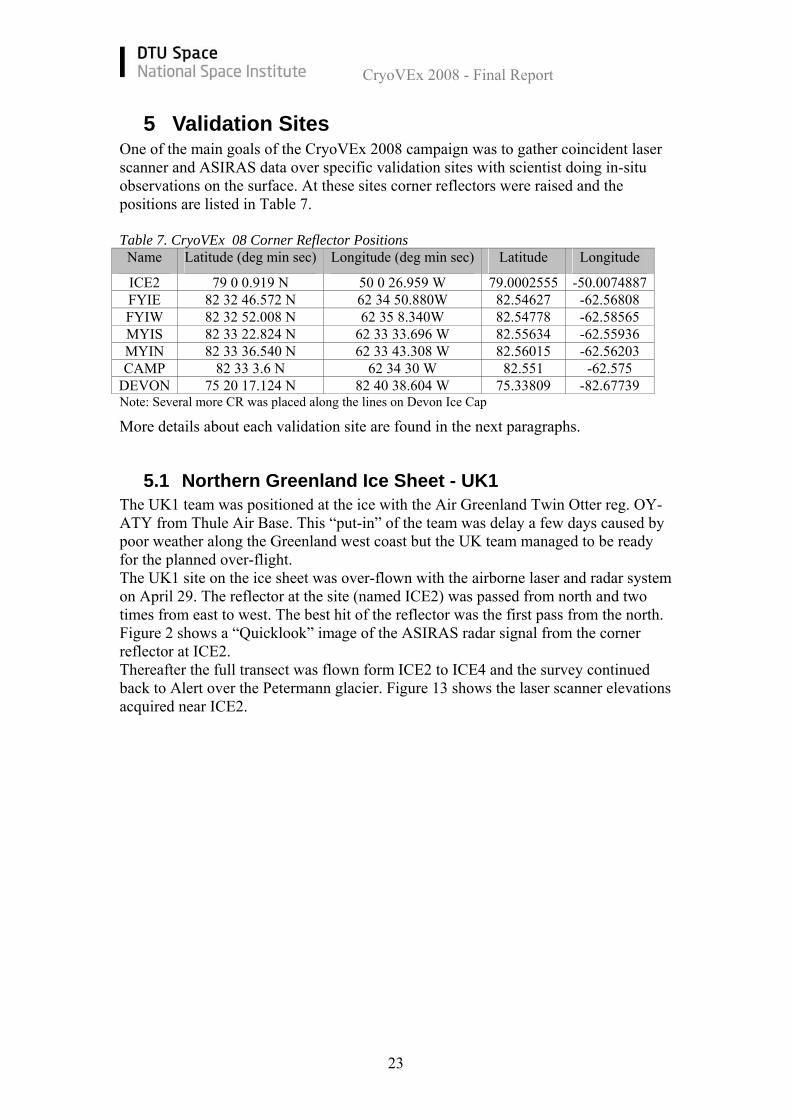
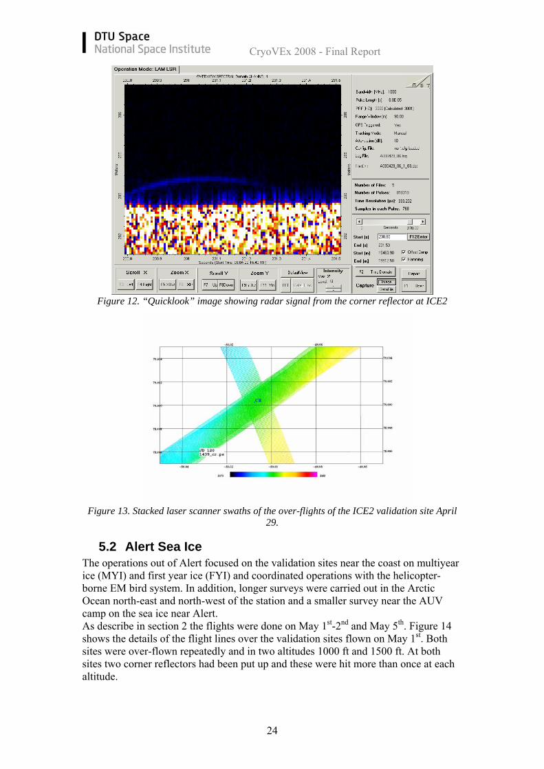
5.1 Northern Greenland Ice Sheet - UK1 The UK1 team was positioned at the ice with the Air Greenland Twin Otter reg. OY-ATY from Thule Air Base. This “put-in” of the team was delay a few days caused by poor weather along the Greenland west coast but the UK team managed to be ready for the planned over-flight. The UK1 site on the ice sheet was over-flown with the airborne laser and radar system on April 29. The reflector at the site (named ICE2) was passed from north and two times from east to west. The best hit of the reflector was the first pass from the north. Figure 2 shows a “Quicklook” image of the ASIRAS radar signal from the corner reflector at ICE2. Thereafter the full transect was flown form ICE2 to ICE4 and the survey continued back to Alert over the Petermann glacier. Figure 13 shows the laser scanner elevations acquired near ICE2.
CryoVEx 2008 - Final Report
24
Figure 12. “Quicklook” image showing radar signal from the corner reflector at ICE2
Figure 13. Stacked laser scanner swaths of the over-flights of the ICE2 validation site April 29.
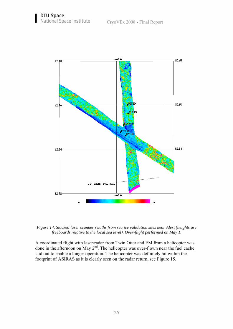
5.2 Alert Sea Ice The operations out of Alert focused on the validation sites near the coast on multiyear ice (MYI) and first year ice (FYI) and coordinated operations with the helicopter-borne EM bird system. In addition, longer surveys were carried out in the Arctic Ocean north-east and north-west of the station and a smaller survey near the AUV camp on the sea ice near Alert. As describe in section 2 the flights were done on May 1st-2nd and May 5th. Figure 14 shows the details of the flight lines over the validation sites flown on May 1st. Both sites were over-flown repeatedly and in two altitudes 1000 ft and 1500 ft. At both sites two corner reflectors had been put up and these were hit more than once at each altitude.
CryoVEx 2008 - Final Report
25
Figure 14. Stacked laser scanner swaths from sea ice validation sites near Alert (heights are freeboards relative to the local sea level). Over-flight performed on May 1.
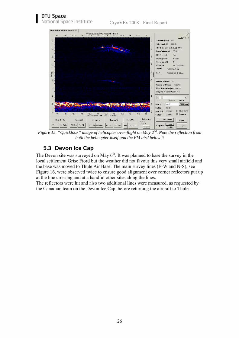
A coordinated flight with laser/radar from Twin Otter and EM from a helicopter was done in the afternoon on May 2nd. The helicopter was over-flown near the fuel cache laid out to enable a longer operation. The helicopter was definitely hit within the footprint of ASIRAS as it is clearly seen on the radar return, see Figure 15.
CryoVEx 2008 - Final Report
26
Figure 15. “Quicklook” image of helicopter over-flight on May 2nd. Note the reflection from both the helicopter itself and the EM bird below it
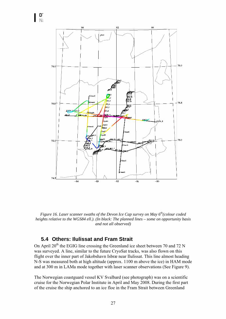
5.3 Devon Ice Cap The Devon site was surveyed on May 6th. It was planned to base the survey in the local settlement Grise Fiord but the weather did not favour this very small airfield and the base was moved to Thule Air Base. The main survey lines (E-W and N-S), see Figure 16, were observed twice to ensure good alignment over corner reflectors put up at the line crossing and at a handful other sites along the lines. The reflectors were hit and also two additional lines were measured, as requested by the Canadian team on the Devon Ice Cap, before returning the aircraft to Thule.
CryoVEx 2008 - Final Report
27
Figure 16. Laser scanner swaths of the Devon Ice Cap survey on May 6th(colour coded
heights relative to the WGS84 ell.). (In black: The planned lines – some on opportunity basis and not all observed)
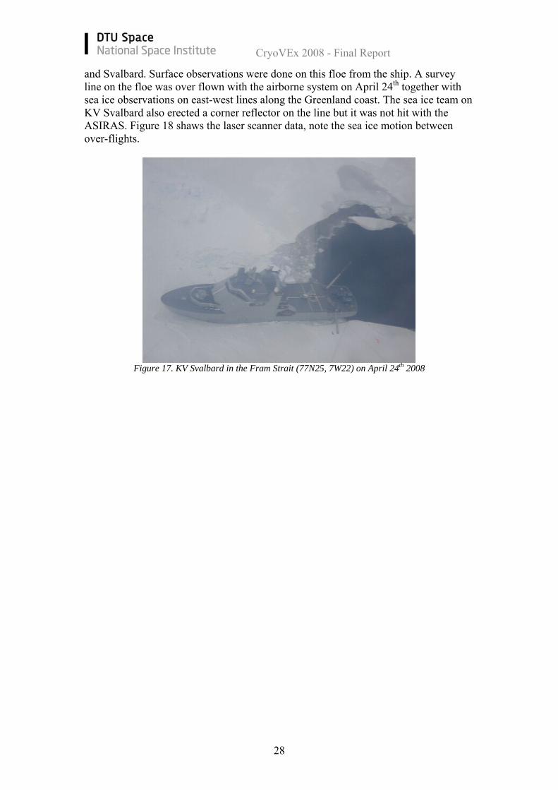
5.4 Others: Ilulissat and Fram Strait On April 20th the EGIG line crossing the Greenland ice sheet between 70 and 72 N was surveyed. A line, similar to the future CryoSat tracks, was also flown on this flight over the inner part of Jakobshavn Isbræ near Ilulissat. This line almost heading N-S was measured both at high altitude (approx. 1100 m above the ice) in HAM mode and at 300 m in LAMa mode together with laser scanner observations (See Figure 9). The Norwegian coastguard vessel KV Svalbard (see photograph) was on a scientific cruise for the Norwegian Polar Institute in April and May 2008. During the first part of the cruise the ship anchored to an ice floe in the Fram Strait between Greenland
CryoVEx 2008 - Final Report
28
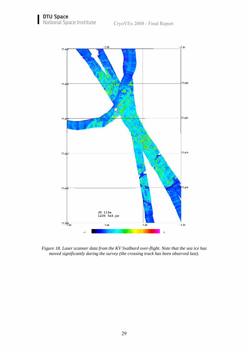
and Svalbard. Surface observations were done on this floe from the ship. A survey line on the floe was over flown with the airborne system on April 24th together with sea ice observations on east-west lines along the Greenland coast. The sea ice team on KV Svalbard also erected a corner reflector on the line but it was not hit with the ASIRAS. Figure 18 shaws the laser scanner data, note the sea ice motion between over-flights.
Figure 17. KV Svalbard in the Fram Strait (77N25, 7W22) on April 24th 2008
CryoVEx 2008 - Final Report
29
Figure 18. Laser scanner data from the KV Svalbard over-flight. Note that the sea ice has
moved significantly during the survey (the crossing track has been observed last).
CryoVEx 2008 - Final Report
30
6 Conclusions The airborne part of CryoVEx 2008 has successfully been carried out by DTU Space and the gathered data sets are now secured at DTU Space on central servers backed up on magnetic tapes. A total of 72 hr were flown with the Air Greenland Twin Otter plus additional 15 hrs for the transport of the UK1 team to the ice sheet. Laser scanner data has been gathered on most lines and ASIRAS data was recorded over test sites and on large parts of the other lines. The laser scanner, INS, and GPS data has been processed by DTU Space and the ASIRAS data by AWI.
CryoVEx 2008 - Final Report
31
7 References Cullen, R.: ASIRAS, Product Description, Issue: 2.5. European Space Agency, 2007 Haas, C, S. Hanson, S. Hendricks: CryoVEx 2008 Field report of in-situ measurements, 2008 Helm, V., S. Hendricks, S. Goebell, W. Rack, C. Haas, U. Nixdorf, and T. Boebel: CryoVEx 2004 and 2005 (bob) data acquisition and final report. Technical Report 1.0, Alfred Wegener Institute, 2006. Zhang, X.: Precise Point Positioning – Evaluation and Airborne Lidar Calibration. Technical Report No. 4, Danish National Space Center, pp. 44, 2006.
CryoVEx 2008 - Final Report
32
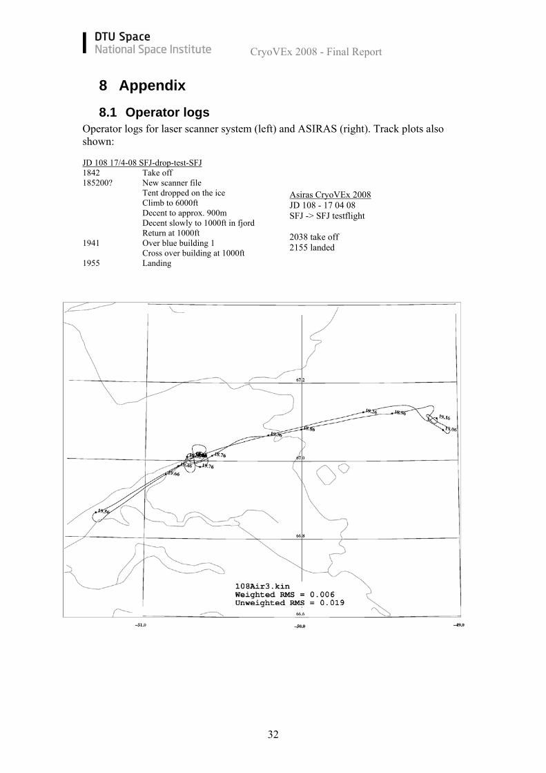
8 Appendix
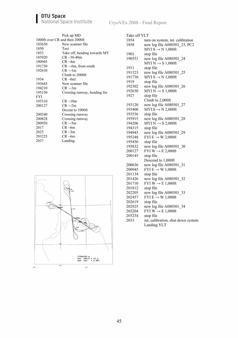
8.1 Operator logs Operator logs for laser scanner system (left) and ASIRAS (right). Track plots also shown: JD 108 17/4-08 SFJ-drop-test-SFJ 1842 Take off 185200? New scanner file Tent dropped on the ice Climb to 6000ft Decent to approx. 900m Decent slowly to 1000ft in fjord Return at 1000ft 1941 Over blue building 1 Cross over building at 1000ft 1955 Landing
Asiras CryoVEx 2008 JD 108 - 17 04 08 SFJ -> SFJ testflight 2038 take off 2155 landed
CryoVEx 2008 - Final Report
33
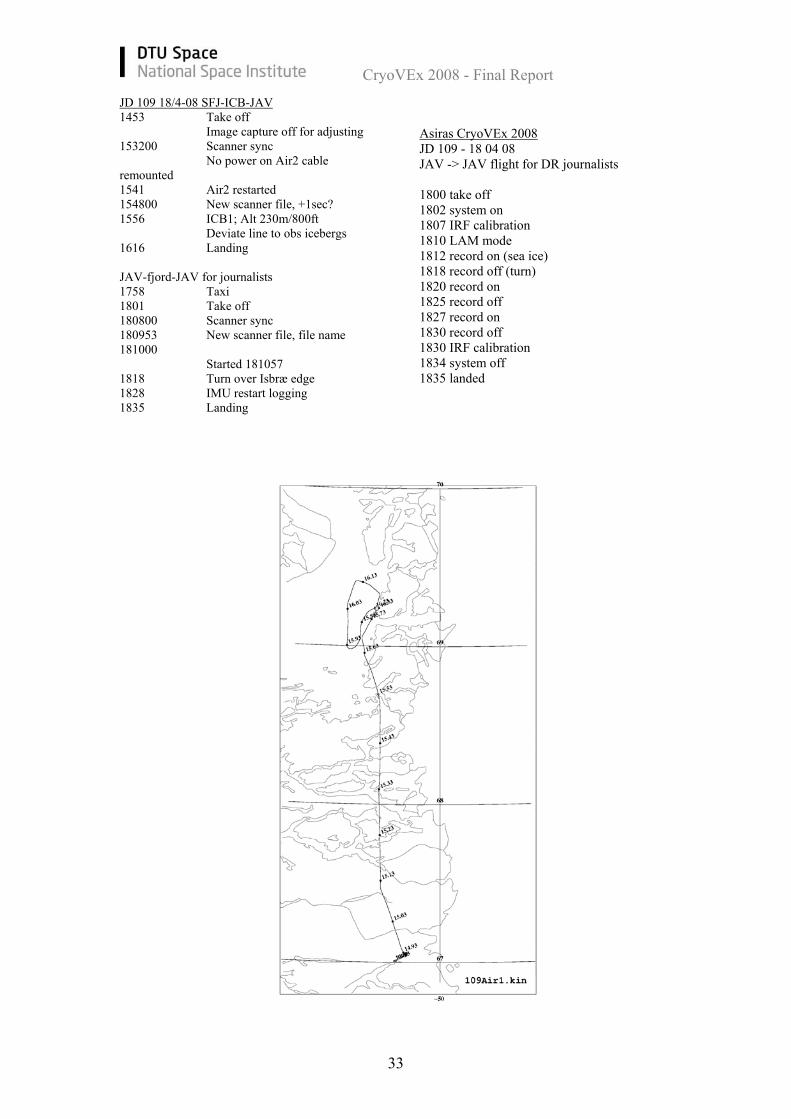
JD 109 18/4-08 SFJ-ICB-JAV 1453 Take off Image capture off for adjusting 153200 Scanner sync No power on Air2 cable remounted 1541 Air2 restarted 154800 New scanner file, +1sec? 1556 ICB1; Alt 230m/800ft Deviate line to obs icebergs 1616 Landing JAV-fjord-JAV for journalists 1758 Taxi 1801 Take off 180800 Scanner sync 180953 New scanner file, file name 181000 Started 181057 1818 Turn over Isbræ edge 1828 IMU restart logging 1835 Landing
Asiras CryoVEx 2008 JD 109 - 18 04 08 JAV -> JAV flight for DR journalists 1800 take off 1802 system on 1807 IRF calibration 1810 LAM mode 1812 record on (sea ice) 1818 record off (turn) 1820 record on 1825 record off 1827 record on 1830 record off 1830 IRF calibration 1834 system off 1835 landed
CryoVEx 2008 - Final Report
34
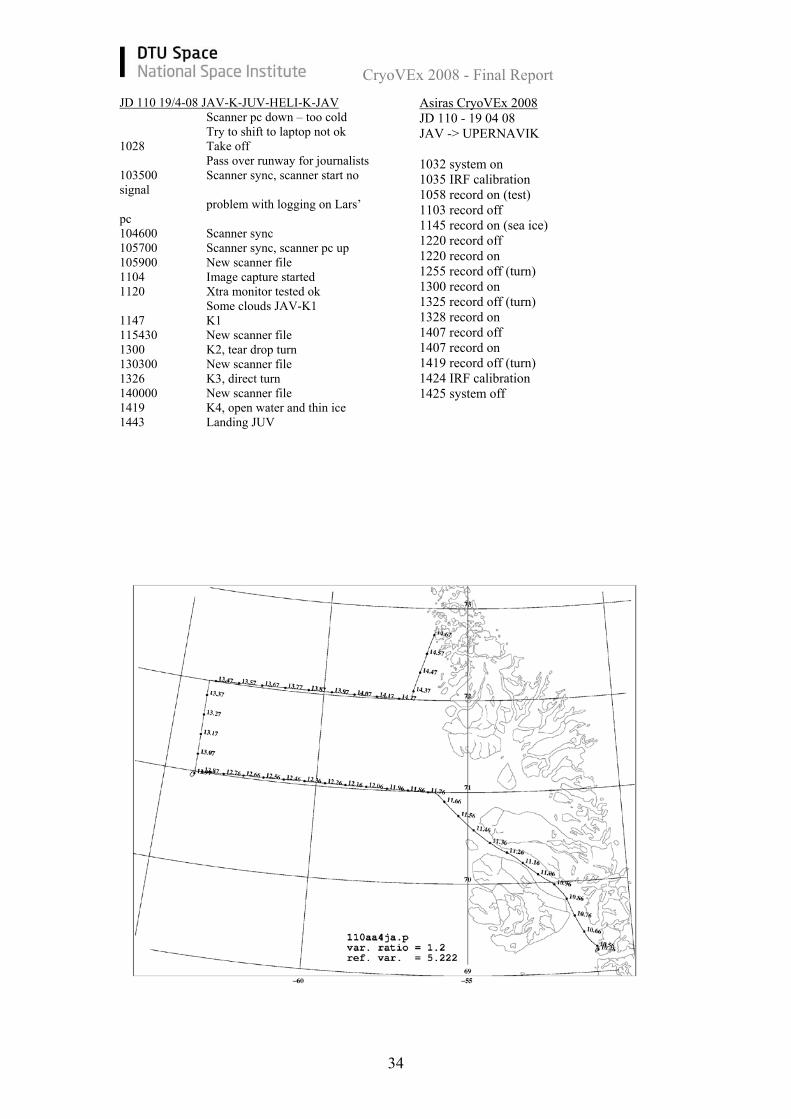
JD 110 19/4-08 JAV-K-JUV-HELI-K-JAV Scanner pc down – too cold Try to shift to laptop not ok 1028 Take off Pass over runway for journalists 103500 Scanner sync, scanner start no signal problem with logging on Lars’ pc 104600 Scanner sync 105700 Scanner sync, scanner pc up 105900 New scanner file 1104 Image capture started 1120 Xtra monitor tested ok Some clouds JAV-K1 1147 K1 115430 New scanner file 1300 K2, tear drop turn 130300 New scanner file 1326 K3, direct turn 140000 New scanner file 1419 K4, open water and thin ice 1443 Landing JUV
Asiras CryoVEx 2008 JD 110 - 19 04 08 JAV -> UPERNAVIK 1032 system on 1035 IRF calibration 1058 record on (test) 1103 record off 1145 record on (sea ice) 1220 record off 1220 record on 1255 record off (turn) 1300 record on 1325 record off (turn) 1328 record on 1407 record off 1407 record on 1419 record off (turn) 1424 IRF calibration 1425 system off
CryoVEx 2008 - Final Report
35
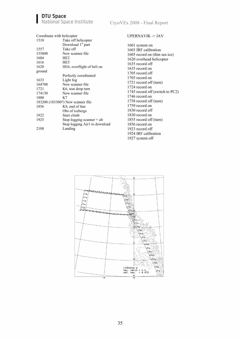
Coordinate with helicopter 1510 Take off helicopter Download 1st part 1557 Take off 155800 New scanner file 1604 HE2 1616 HE5 1620 HE6, overflight of heli on ground Perfectly coordinated 1633 Light fog 164700 New scanner file 1721 K6, tear drop turn 174130 New scanner file 1800 K7 183200 (183300?) New scanner file 1856 K8, end of line Obs of icebergs 1922 Start climb 1925 Stop logging scanner + alt Stop logging Air1 to download 2108 Landing
UPERNAVIK -> JAV 1601 system on 1603 IRF calibration 1605 record on (thin sea ice) 1620 overhead helicopter 1635 record off 1635 record on 1705 record off 1705 record on 1721 record off (turn) 1724 record on 1745 record off (switch to PC2) 1746 record on 1758 record off (turn) 1759 record on 1830 record off 1830 record on 1855 record off (turn) 1856 record on 1923 record off 1924 IRF calibration 1927 system off
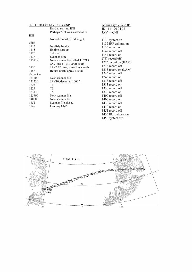
JD 111 20/4-08 JAV-EGIG-CNP Hard to start up EGI Perhaps Air1 was started after EGI No lock on sat, fixed height align 1113 NavRdy finally 1115 Engine start up 1125 Take off 11?? Scanner sync 113718 New scanner file called 113715 JAV line 1-10, 1000ft south 1150 JAV5 1st time, some low clouds 1156 Return north, aprox 1100m above ice 121200 New scanner file 121230 JAV10, decent to 1000ft 1223 T1 1227 T3 123130 T5 125700 New scanner file 140000 New scanner file 1452 Scanner file closed 1548 Landing CNP
Asiras CryoVEx 2008 JD 111 - 20 04 08 JAV -> CNP 1130 system on 1132 IRF calibration 1135 record on 1142 record off 1144 record on ???? record off 12?? record on (HAM) 1213 record off 1215 record on (LAM) 1246 record off 1246 record on 1313 record off 1313 record on 1330 record off 1330 record on 1400 record off 1400 record on 1430 record off 1430 record on 1451 record off 1455 IRF calibration 1458 system off

CryoVEx 2008 - Final Report
37
JD 112 21/4-08 CNP-K-DNB-Krev-NRD Scanner sync on ground
Pobl with EMAP start up Perhaps problems with seriel port on laptop 1000 Engine start 1010 Taxi 1014 Take off 101630 New scanner file 1030 EMAP up on smh laptop 1040 Decent to 1000ft 1045 End of fast ice 110900 New scanner file 1115 K9 tear drop turn 1123 Low clouds 1130 Climb to 460m 1144 Scanner file closed 115400 New scanner file (start 04) Clouds partly broken 1201 Decent, try to get under clouds 1204 Icing, climb 1220 Broken clouds, 660m alti, some scanner 1228 K10, 750m, only ASIRAS 1238 800m 1254 K11, clouds, only little sea ice 134630 New scanner file still in clouds 1358 K12 1407 Overflight runway DNB
ASIRAS log: 21/4-2008, JD 112: Operator: HSK Flight: CNP-DNB, DNB-NRD: Take off Constable Pynt 1116 start log file A080421_00, flight altitude 300m 1130 Ascend to 480m 1142 Ascend to 540m 1200 Descend to 300m 1203 new log file A080421_01 Climb to 660m 1222 climb to 720m 1227 turn – stop logging 1254 new log file A080421_02 1301 climb to 900m climb to 960m 1309 descend to 900m 1311 descend to 840m 1333 descend to 660m 1337 descend to 540m 1340 descend to 420m 1350 descend to 360m 1309 descend to 300m 1356 stop logging 1357 calibration Landing Daneborg

1410 Landing DNB Fueling, 1 engine running for instruments 1507 Taxi 1510 Take off 1540 After Shannon Island in fog again 1610 Deviate line, direct north 163130 New scanner file 1634 1000ft, turn towards K15 1642 Long leads and large patches without leads 1723 K15, turn direct towards NRD 172500 New scanner file 181400 New scanner file fog/low clouds – some broken 1843 Scanner logging stopped 185900 New scanner file 1935 Flade isblink start 2000 Landing NRD
Take off Daneborg 1533 new log file A080421_03, 300m 1544 climb to 600m 1601 new log file A080421_04 1615 new log file A080421_05 1635 new log file A080421_06 1652 new log file A080421_07, 300m 1714 new log file A080421_08 1721 turn new log file A080421_10 1735 new log file A080421_11 1749 new log file A080421_12 frostflowers 1812 PC1 full change to PC2 new log file A080421_13 1829 new log file A080421_14 1843 new log file A080421_15 1859 new log file A080421_16 1914 new log file A080421_17 1929 stop radar Calibration Shut down system Landing St. Nord
CryoVEx 2008 - Final Report
39
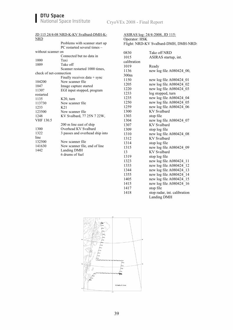
JD 115 24/4-08 NRD-K-KV Svalbard-DMH-K-NRD Problems with scanner start up PC restarted several times – without scanner on Connected but no data in 1000 Taxi 1009 Take off Scanner restarted 1000 times, check of net-connection Finally receives data + sync 104200 New scanner file 1047 Image capture started 1130? EGI input stopped, program restarted 1135 K20, turn 113730 New scanner file 1233 K21 123500 New scanner file 1248 KV Svalbard, 77 25N 7 22W, VHF 130.5 200 m line east of ship 1300 Overhead KV Svalbard 1322 3 passes and overhead ship into line 132500 New scanner file 141630 New scanner file, end of line 1442 Landing DMH 6 drums of fuel
ASIRAS log: 24/4-2008, JD 115: Operator: HSK Flight: NRD-KV Svalbard-DMH, DMH-NRD: 0830 Take off NRD 1015 ASIRAS startup, int. calibration 1019 Ready 1136 new log file A080424_00, 300m 1150 new log file A080424_01 1205 new log file A080424_02 1220 new log file A080424_03 1233 log stopped, turn 1235 new log file A080424_04 1250 new log file A080424_05 1259 new log file A080424_06 1300 KV Svalbard 1303 stop file 1304 new log file A080424_07 1307 KV Svalbard 1309 stop log file 1310 new log file A080424_08 1312 KV Svalbard 1314 stop log file 1315 new log file A080424_09 13 KV Svalbard 1319 stop log file 1323 new log file A080424_11 1333 new log file A080424_12 1344 new log file A080424_13 1355 new log file A080424_14 1405 new log file A080424_15 1415 new log file A080424_16 1417 stop file 1418 stop radar, int. calibration Landing DMH
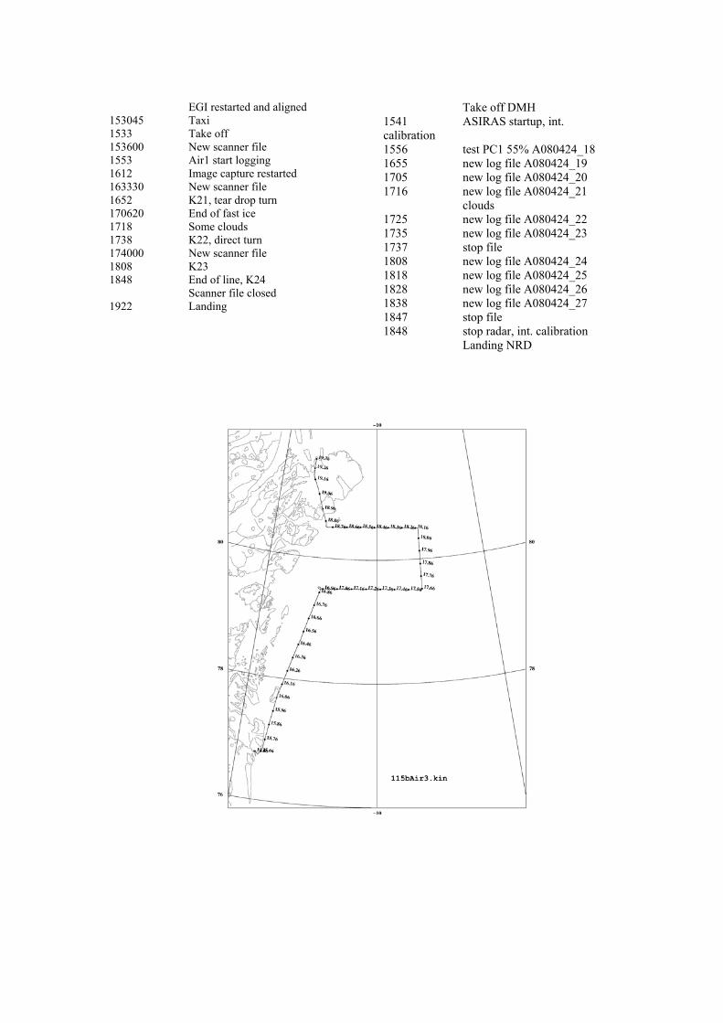
EGI restarted and aligned 153045 Taxi 1533 Take off 153600 New scanner file 1553 Air1 start logging 1612 Image capture restarted 163330 New scanner file 1652 K21, tear drop turn 170620 End of fast ice 1718 Some clouds 1738 K22, direct turn 174000 New scanner file 1808 K23 1848 End of line, K24 Scanner file closed 1922 Landing
Take off DMH 1541 ASIRAS startup, int. calibration 1556 test PC1 55% A080424_18 1655 new log file A080424_19 1705 new log file A080424_20 1716 new log file A080424_21 clouds 1725 new log file A080424_22 1735 new log file A080424_23 1737 stop file 1808 new log file A080424_24 1818 new log file A080424_25 1828 new log file A080424_26 1838 new log file A080424_27 1847 stop file 1848 stop radar, int. calibration Landing NRD
CryoVEx 2008 - Final Report
41
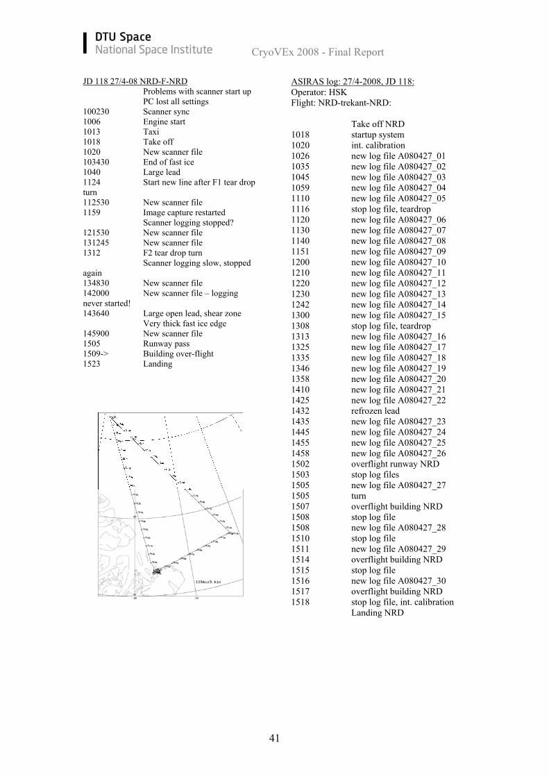
JD 118 27/4-08 NRD-F-NRD Problems with scanner start up PC lost all settings 100230 Scanner sync 1006 Engine start 1013 Taxi 1018 Take off 1020 New scanner file 103430 End of fast ice 1040 Large lead 1124 Start new line after F1 tear drop turn 112530 New scanner file 1159 Image capture restarted Scanner logging stopped? 121530 New scanner file 131245 New scanner file 1312 F2 tear drop turn Scanner logging slow, stopped again 134830 New scanner file 142000 New scanner file – logging never started! 143640 Large open lead, shear zone Very thick fast ice edge 145900 New scanner file 1505 Runway pass 1509-> Building over-flight 1523 Landing
ASIRAS log: 27/4-2008, JD 118: Operator: HSK Flight: NRD-trekant-NRD: Take off NRD 1018 startup system 1020 int. calibration 1026 new log file A080427_01 1035 new log file A080427_02 1045 new log file A080427_03 1059 new log file A080427_04 1110 new log file A080427_05 1116 stop log file, teardrop 1120 new log file A080427_06 1130 new log file A080427_07 1140 new log file A080427_08 1151 new log file A080427_09 1200 new log file A080427_10 1210 new log file A080427_11 1220 new log file A080427_12 1230 new log file A080427_13 1242 new log file A080427_14 1300 new log file A080427_15 1308 stop log file, teardrop 1313 new log file A080427_16 1325 new log file A080427_17 1335 new log file A080427_18 1346 new log file A080427_19 1358 new log file A080427_20 1410 new log file A080427_21 1425 new log file A080427_22 1432 refrozen lead 1435 new log file A080427_23 1445 new log file A080427_24 1455 new log file A080427_25 1458 new log file A080427_26 1502 overflight runway NRD 1503 stop log files 1505 new log file A080427_27 1505 turn 1507 overflight building NRD 1508 stop log file 1508 new log file A080427_28 1510 stop log file 1511 new log file A080427_29 1514 overflight building NRD 1515 stop log file 1516 new log file A080427_30 1517 overflight building NRD 1518 stop log file, int. calibration Landing NRD
CryoVEx 2008 - Final Report
42
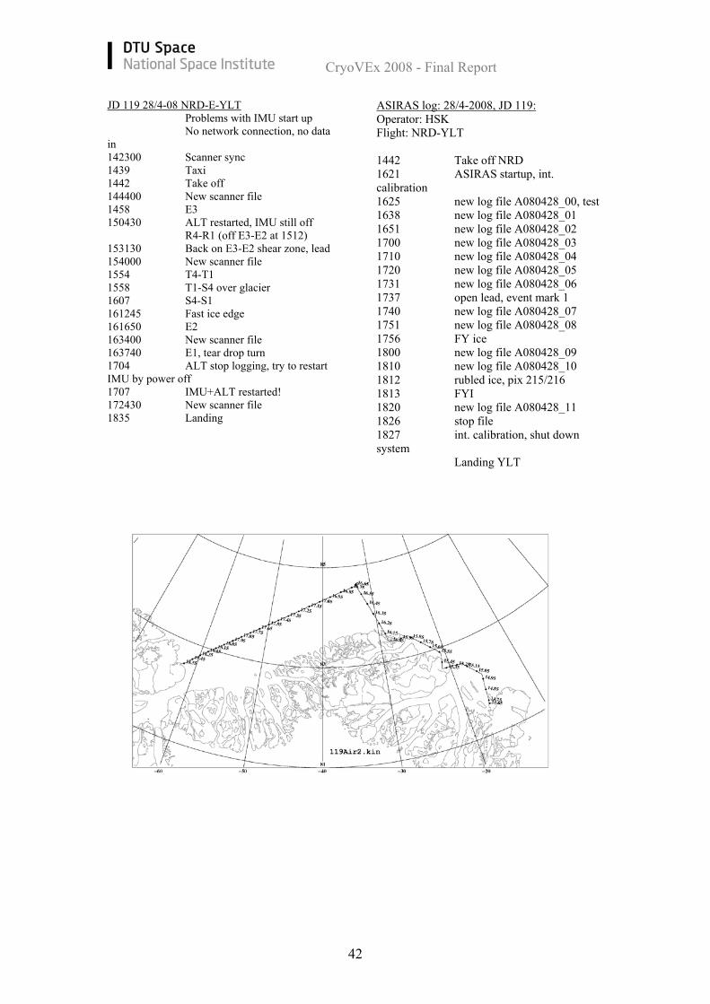
JD 119 28/4-08 NRD-E-YLT Problems with IMU start up No network connection, no data in 142300 Scanner sync 1439 Taxi 1442 Take off 144400 New scanner file 1458 E3 150430 ALT restarted, IMU still off R4-R1 (off E3-E2 at 1512) 153130 Back on E3-E2 shear zone, lead 154000 New scanner file 1554 T4-T1 1558 T1-S4 over glacier 1607 S4-S1 161245 Fast ice edge 161650 E2 163400 New scanner file 163740 E1, tear drop turn 1704 ALT stop logging, try to restart IMU by power off 1707 IMU+ALT restarted! 172430 New scanner file 1835 Landing
ASIRAS log: 28/4-2008, JD 119: Operator: HSK Flight: NRD-YLT 1442 Take off NRD 1621 ASIRAS startup, int. calibration 1625 new log file A080428_00, test 1638 new log file A080428_01 1651 new log file A080428_02 1700 new log file A080428_03 1710 new log file A080428_04 1720 new log file A080428_05 1731 new log file A080428_06 1737 open lead, event mark 1 1740 new log file A080428_07 1751 new log file A080428_08 1756 FY ice 1800 new log file A080428_09 1810 new log file A080428_10 1812 rubled ice, pix 215/216 1813 FYI 1820 new log file A080428_11 1826 stop file 1827 int. calibration, shut down system Landing YLT
CryoVEx 2008 - Final Report
43
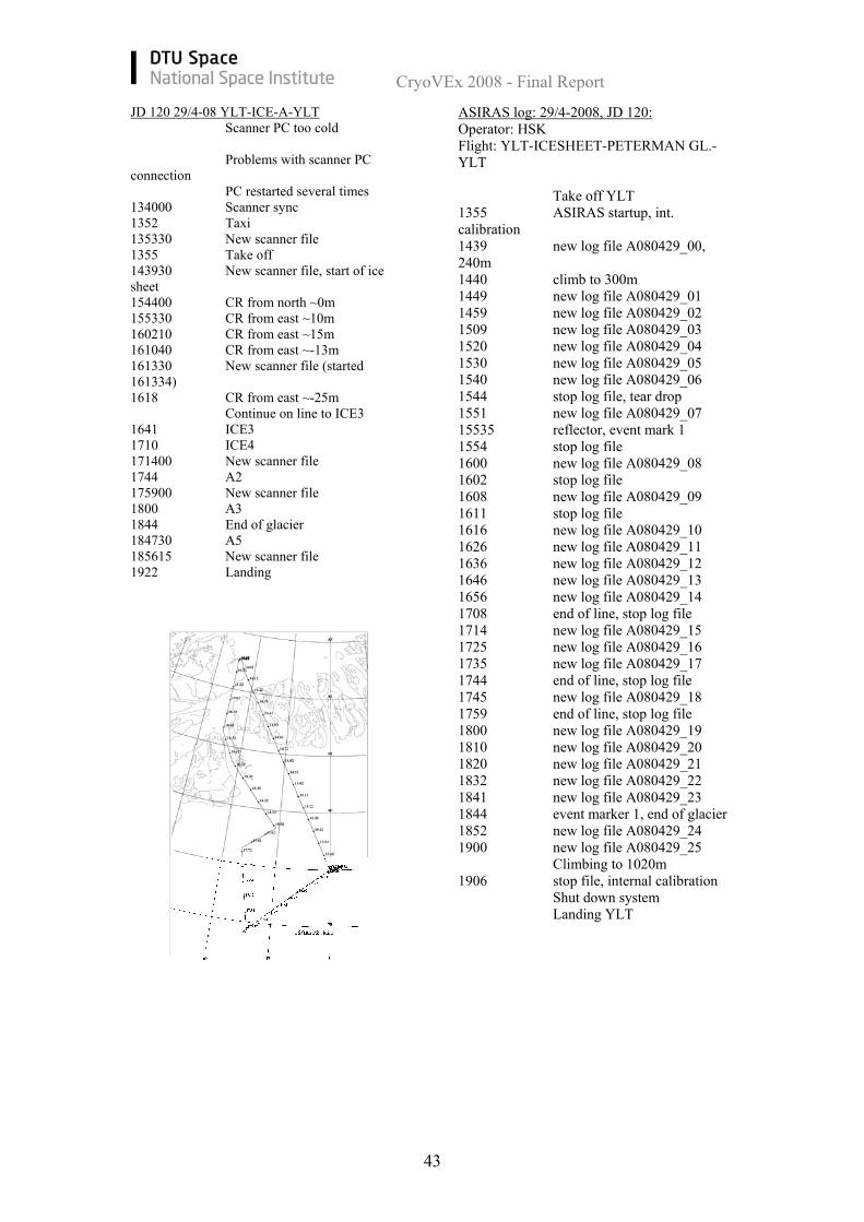
JD 120 29/4-08 YLT-ICE-A-YLT Scanner PC too cold
Problems with scanner PC connection PC restarted several times 134000 Scanner sync 1352 Taxi 135330 New scanner file 1355 Take off 143930 New scanner file, start of ice sheet 154400 CR from north ~0m 155330 CR from east ~10m 160210 CR from east ~15m 161040 CR from east ~-13m 161330 New scanner file (started 161334) 1618 CR from east ~-25m Continue on line to ICE3 1641 ICE3 1710 ICE4 171400 New scanner file 1744 A2 175900 New scanner file 1800 A3 1844 End of glacier 184730 A5 185615 New scanner file 1922 Landing
ASIRAS log: 29/4-2008, JD 120: Operator: HSK Flight: YLT-ICESHEET-PETERMAN GL.-YLT Take off YLT 1355 ASIRAS startup, int. calibration 1439 new log file A080429_00, 240m 1440 climb to 300m 1449 new log file A080429_01 1459 new log file A080429_02 1509 new log file A080429_03 1520 new log file A080429_04 1530 new log file A080429_05 1540 new log file A080429_06 1544 stop log file, tear drop 1551 new log file A080429_07 15535 reflector, event mark 1 1554 stop log file 1600 new log file A080429_08 1602 stop log file 1608 new log file A080429_09 1611 stop log file 1616 new log file A080429_10 1626 new log file A080429_11 1636 new log file A080429_12 1646 new log file A080429_13 1656 new log file A080429_14 1708 end of line, stop log file 1714 new log file A080429_15 1725 new log file A080429_16 1735 new log file A080429_17 1744 end of line, stop log file 1745 new log file A080429_18 1759 end of line, stop log file 1800 new log file A080429_19 1810 new log file A080429_20 1820 new log file A080429_21 1832 new log file A080429_22 1841 new log file A080429_23 1844 event marker 1, end of glacier 1852 new log file A080429_24 1900 new log file A080429_25 Climbing to 1020m 1906 stop file, internal calibration Shut down system Landing YLT
CryoVEx 2008 - Final Report
44
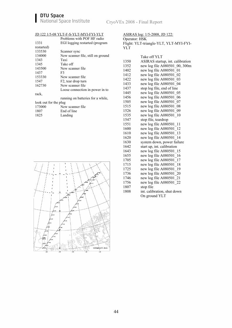
JD 122 1/5-08 YLT-F-S-YLT-MYI-FYI-YLT Problems with POF HF radio 1331 EGI logging restarted (program restarted) 133530 Scanner sync 134000 New scanner file, still on ground 1343 Taxi 1345 Take off 143500 New scanner file 1437 F3 153330 New scanner file 1547 F2, tear drop turn 162730 New scanner file Loose connection in power in to rack,
running on batteries for a while, look out for the plug 173000 New scanner file 1807 End of line 1825 Landing
ASIRAS log: 1/5-2008, JD 122: Operator: HSK Flight: YLT-triangle-YLT, YLT-MYI-FYI-YLT Take off YLT 1350 ASIRAS startup, int. calibration 1352 new log file A080501_00, 300m 1402 new log file A080501_01 1412 new log file A080501_02 1422 new log file A080501_03 1433 new log file A080501_04 1437 stop log file, end of line 1445 new log file A080501_05 1456 new log file A080501_06 1505 new log file A080501_07 1515 new log file A080501_08 1526 new log file A080501_09 1535 new log file A080501_10 1547 stop file, teardrop 1551 new log file A080501_11 1600 new log file A080501_12 1610 new log file A080501_13 1620 new log file A080501_14 1630 system down, power failure 1642 start up, int. calibration 1643 new log file A080501_15 1655 new log file A080501_16 1705 new log file A080501_17 1715 new log file A080501_18 1725 new log file A080501_19 1736 new log file A080501_20 1746 new log file A080501_21 1756 new log file A080501_22 1807 stop file 1808 int. calibration, shut down On ground YLT
CryoVEx 2008 - Final Report
45
Pick up MD 1000ft over CR and then 2000ft 183630 New scanner file 1850 Taxi 1852 Take off, heading towards MY 185920 CR ~30-40m 190945 CR ~4m 191730 CR ~-6m, from south 192630 CR ~-1m Climb to 2000ft 1934 CR ~0m! 193645 New scanner file 194210 CR ~-3m 195150 Crossing runway, heading for FYI 195310 CR ~10m 200127 CR ~-2m Decent to 1000ft 200240 Crossing runway 200828 Crossing runway 200950 CR ~-5m 2017 CR ~6m 2025 CR ~3m 203225 CR ~6m 2037 Landing
Take off YLT 1854 turn on system, int. calibration 1858 new log file A080501_23, PC2 MYI S → N 1,000ft 1901 stop file 190551 new log file A080501_24 MYI N → S 1,000ft 1911 stop file 191523 new log file A080501_25 191730 MYI S → N 1,000ft 1919 stop file 192302 new log file A080501_26 192630 MYI N → S 1,000ft 1927 stop file Climb to 2,000ft 193120 new log file A080501_27 193400 MYI S → N 2,000ft 193536 stop file 193915 new log file A080501_28 194206 MYI N → S 2,000ft 194315 stop file 194945 new log file A080501_29 195248 FYI E → W 2,000ft 195456 stop file 195832 new log file A080501_30 200127 FYI W → E 2,000ft 200145 stop file Descend to 1,000ft 200636 new log file A080501_31 200945 FYI E → W 1,000ft 201134 stop file 201426 new log file A080501_32 201710 FYI W → E 1,000ft 201812 stop file 202205 new log file A080501_33 202457 FYI E → W 1,000ft 202619 stop file 202925 new log file A080501_34 203204 FYI W → E 1,000ft 203234 stop file 2033 int, calibration, shut down system Landing YLT
CryoVEx 2008 - Final Report
46
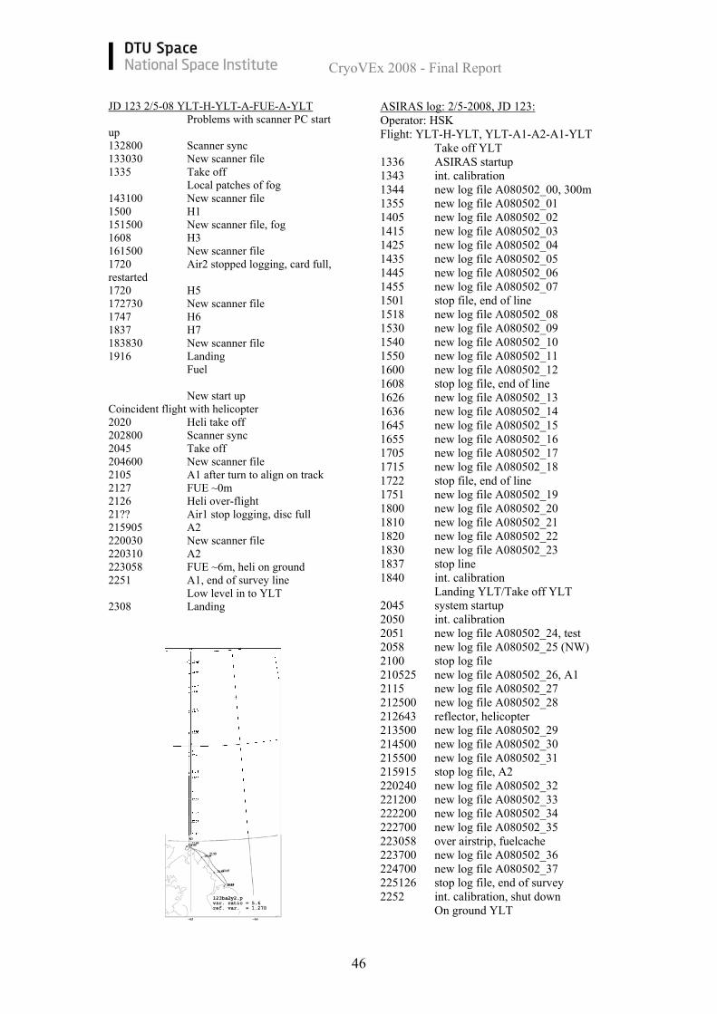
JD 123 2/5-08 YLT-H-YLT-A-FUE-A-YLT Problems with scanner PC start up 132800 Scanner sync 133030 New scanner file 1335 Take off Local patches of fog 143100 New scanner file 1500 H1 151500 New scanner file, fog 1608 H3 161500 New scanner file 1720 Air2 stopped logging, card full, restarted 1720 H5 172730 New scanner file 1747 H6 1837 H7 183830 New scanner file 1916 Landing Fuel New start up Coincident flight with helicopter 2020 Heli take off 202800 Scanner sync 2045 Take off 204600 New scanner file 2105 A1 after turn to align on track 2127 FUE ~0m 2126 Heli over-flight 21?? Air1 stop logging, disc full 215905 A2 220030 New scanner file 220310 A2 223058 FUE ~6m, heli on ground 2251 A1, end of survey line Low level in to YLT 2308 Landing
ASIRAS log: 2/5-2008, JD 123: Operator: HSK Flight: YLT-H-YLT, YLT-A1-A2-A1-YLT Take off YLT 1336 ASIRAS startup 1343 int. calibration 1344 new log file A080502_00, 300m 1355 new log file A080502_01 1405 new log file A080502_02 1415 new log file A080502_03 1425 new log file A080502_04 1435 new log file A080502_05 1445 new log file A080502_06 1455 new log file A080502_07 1501 stop file, end of line 1518 new log file A080502_08 1530 new log file A080502_09 1540 new log file A080502_10 1550 new log file A080502_11 1600 new log file A080502_12 1608 stop log file, end of line 1626 new log file A080502_13 1636 new log file A080502_14 1645 new log file A080502_15 1655 new log file A080502_16 1705 new log file A080502_17 1715 new log file A080502_18 1722 stop file, end of line 1751 new log file A080502_19 1800 new log file A080502_20 1810 new log file A080502_21 1820 new log file A080502_22 1830 new log file A080502_23 1837 stop line 1840 int. calibration Landing YLT/Take off YLT 2045 system startup 2050 int. calibration 2051 new log file A080502_24, test 2058 new log file A080502_25 (NW) 2100 stop log file 210525 new log file A080502_26, A1 2115 new log file A080502_27 212500 new log file A080502_28 212643 reflector, helicopter 213500 new log file A080502_29 214500 new log file A080502_30 215500 new log file A080502_31 215915 stop log file, A2 220240 new log file A080502_32 221200 new log file A080502_33 222200 new log file A080502_34 222700 new log file A080502_35 223058 over airstrip, fuelcache 223700 new log file A080502_36 224700 new log file A080502_37 225126 stop log file, end of survey 2252 int. calibration, shut down On ground YLT
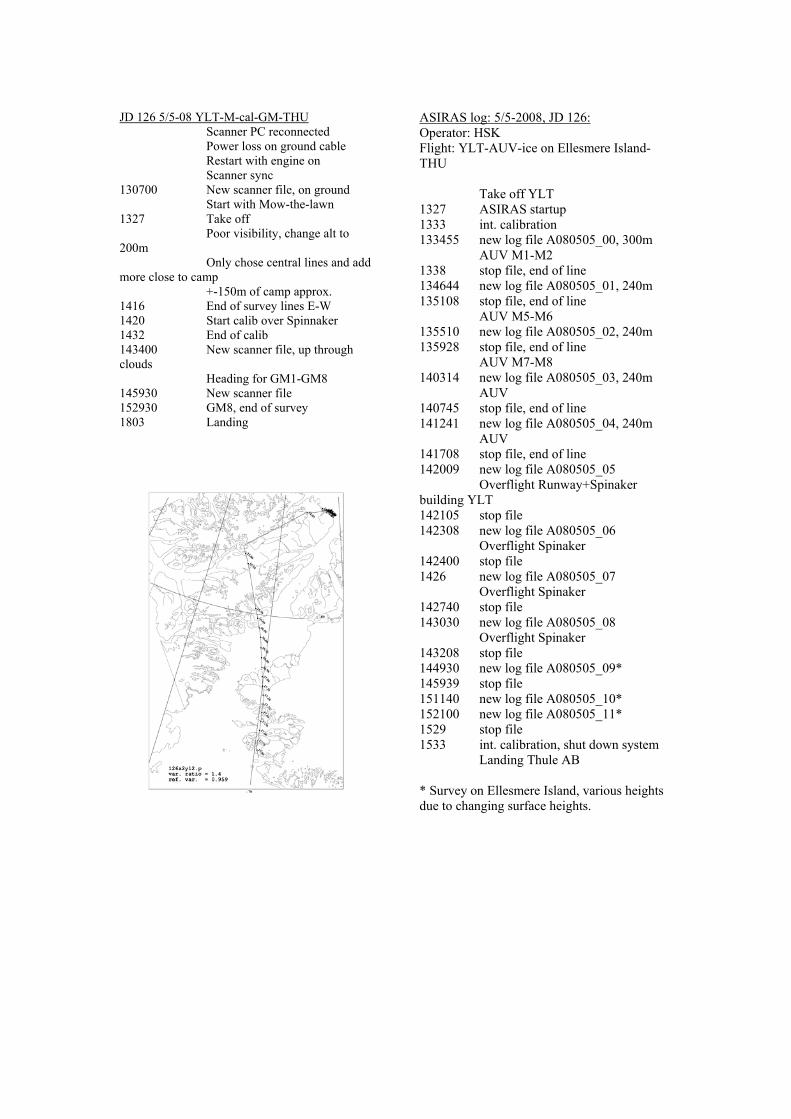
JD 126 5/5-08 YLT-M-cal-GM-THU Scanner PC reconnected Power loss on ground cable Restart with engine on Scanner sync 130700 New scanner file, on ground Start with Mow-the-lawn 1327 Take off Poor visibility, change alt to 200m Only chose central lines and add more close to camp +-150m of camp approx. 1416 End of survey lines E-W 1420 Start calib over Spinnaker 1432 End of calib 143400 New scanner file, up through clouds Heading for GM1-GM8 145930 New scanner file 152930 GM8, end of survey 1803 Landing
ASIRAS log: 5/5-2008, JD 126: Operator: HSK Flight: YLT-AUV-ice on Ellesmere Island-THU Take off YLT 1327 ASIRAS startup 1333 int. calibration 133455 new log file A080505_00, 300m AUV M1-M2 1338 stop file, end of line 134644 new log file A080505_01, 240m 135108 stop file, end of line AUV M5-M6 135510 new log file A080505_02, 240m 135928 stop file, end of line AUV M7-M8 140314 new log file A080505_03, 240m AUV 140745 stop file, end of line 141241 new log file A080505_04, 240m AUV 141708 stop file, end of line 142009 new log file A080505_05 Overflight Runway+Spinaker building YLT 142105 stop file 142308 new log file A080505_06 Overflight Spinaker 142400 stop file 1426 new log file A080505_07 Overflight Spinaker 142740 stop file 143030 new log file A080505_08 Overflight Spinaker 143208 stop file 144930 new log file A080505_09* 145939 stop file 151140 new log file A080505_10* 152100 new log file A080505_11* 1529 stop file 1533 int. calibration, shut down system Landing Thule AB * Survey on Ellesmere Island, various heights due to changing surface heights.
CryoVEx 2008 - Final Report
48
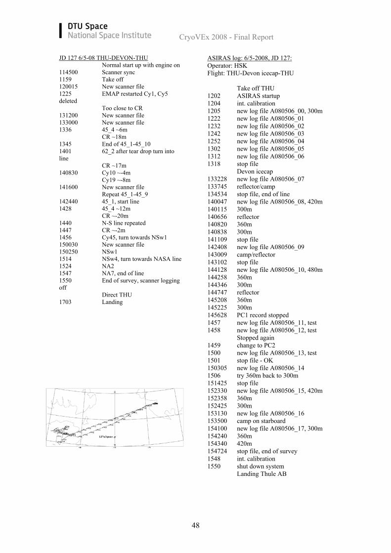
JD 127 6/5-08 THU-DEVON-THU Normal start up with engine on 114500 Scanner sync 1159 Take off 120015 New scanner file 1225 EMAP restarted Cy1, Cy5 deleted Too close to CR 131200 New scanner file 133000 New scanner file 1336 45_4 ~6m CR ~18m 1345 End of 45_1-45_10 1401 62_2 after tear drop turn into line CR ~17m 140830 Cy10 ~-4m Cy19 ~-8m 141600 New scanner file Repeat 45_1-45_9 142440 45_1, start line 1428 45_4 ~12m CR ~-20m 1440 N-S line repeated 1447 CR ~-2m 1456 Cy45, turn towards NSw1 150030 New scanner file 150250 NSw1 1514 NSw4, turn towards NASA line 1524 NA2 1547 NA7, end of line 1550 End of survey, scanner logging off Direct THU 1703 Landing
ASIRAS log: 6/5-2008, JD 127: Operator: HSK Flight: THU-Devon icecap-THU Take off THU 1202 ASIRAS startup 1204 int. calibration 1205 new log file A080506_00, 300m 1222 new log file A080506_01 1232 new log file A080506_02 1242 new log file A080506_03 1252 new log file A080506_04 1302 new log file A080506_05 1312 new log file A080506_06 1318 stop file Devon icecap 133228 new log file A080506_07 133745 reflector/camp 134534 stop file, end of line 140047 new log file A080506_08, 420m 140115 300m 140656 reflector 140820 360m 140838 300m 141109 stop file 142408 new log file A080506_09 143009 camp/reflector 143102 stop file 144128 new log file A080506_10, 480m 144258 360m 144346 300m 144747 reflector 145208 360m 145225 300m 145628 PC1 record stopped 1457 new log file A080506_11, test 1458 new log file A080506_12, test Stopped again 1459 change to PC2 1500 new log file A080506_13, test 1501 stop file - OK 150305 new log file A080506_14 1506 try 360m back to 300m 151425 stop file 152330 new log file A080506_15, 420m 152358 360m 152425 300m 153130 new log file A080506_16 153500 camp on starboard 154100 new log file A080506_17, 300m 154240 360m 154340 420m 154724 stop file, end of survey 1548 int. calibration 1550 shut down system Landing Thule AB
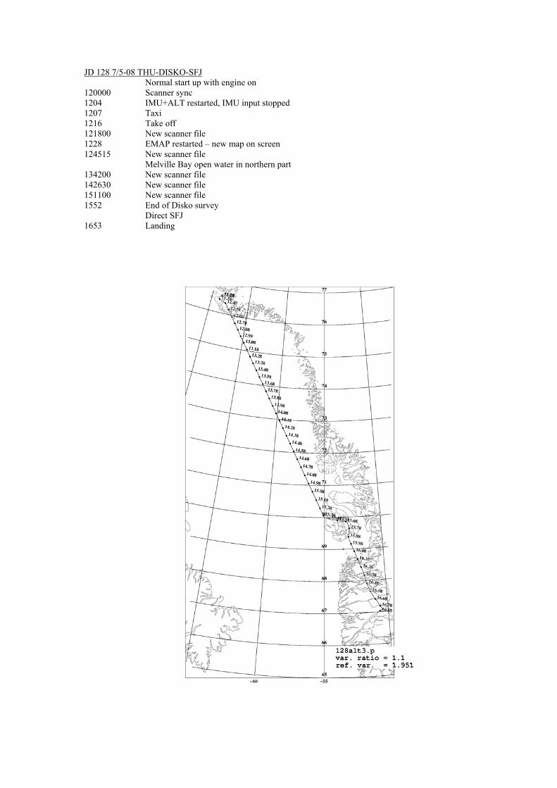
JD 128 7/5-08 THU-DISKO-SFJ Normal start up with engine on 120000 Scanner sync 1204 IMU+ALT restarted, IMU input stopped 1207 Taxi 1216 Take off 121800 New scanner file 1228 EMAP restarted – new map on screen 124515 New scanner file
Melville Bay open water in northern part 134200 New scanner file 142630 New scanner file 151100 New scanner file 1552 End of Disko survey Direct SFJ 1653 Landing
CryoVEx 2008 - Final Report
50
8.2 File formats The file format description for the core products can be found in “ASIRAS, Product Description, Issue 2.5” by R. Cullen (2007) and the user should refer to this document for a detailed description, Especially concerning the ASIRAS products which are not discussed in the following. The definition of the types used in the binary files can be found in Table 8.
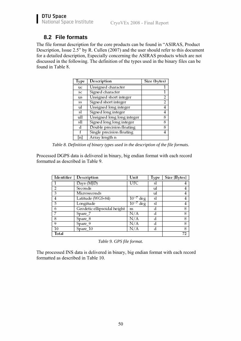
Table 8. Definition of binary types used in the description of the file formats. Processed DGPS data is delivered in binary, big endian format with each record formatted as described in Table 9.
Table 9. GPS file format. The processed INS data is delivered in binary, big endian format with each record formatted as described in Table 10.
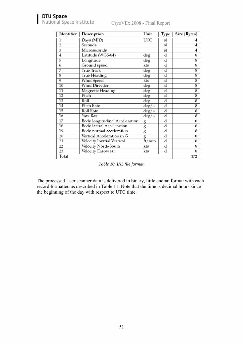
CryoVEx 2008 - Final Report
51
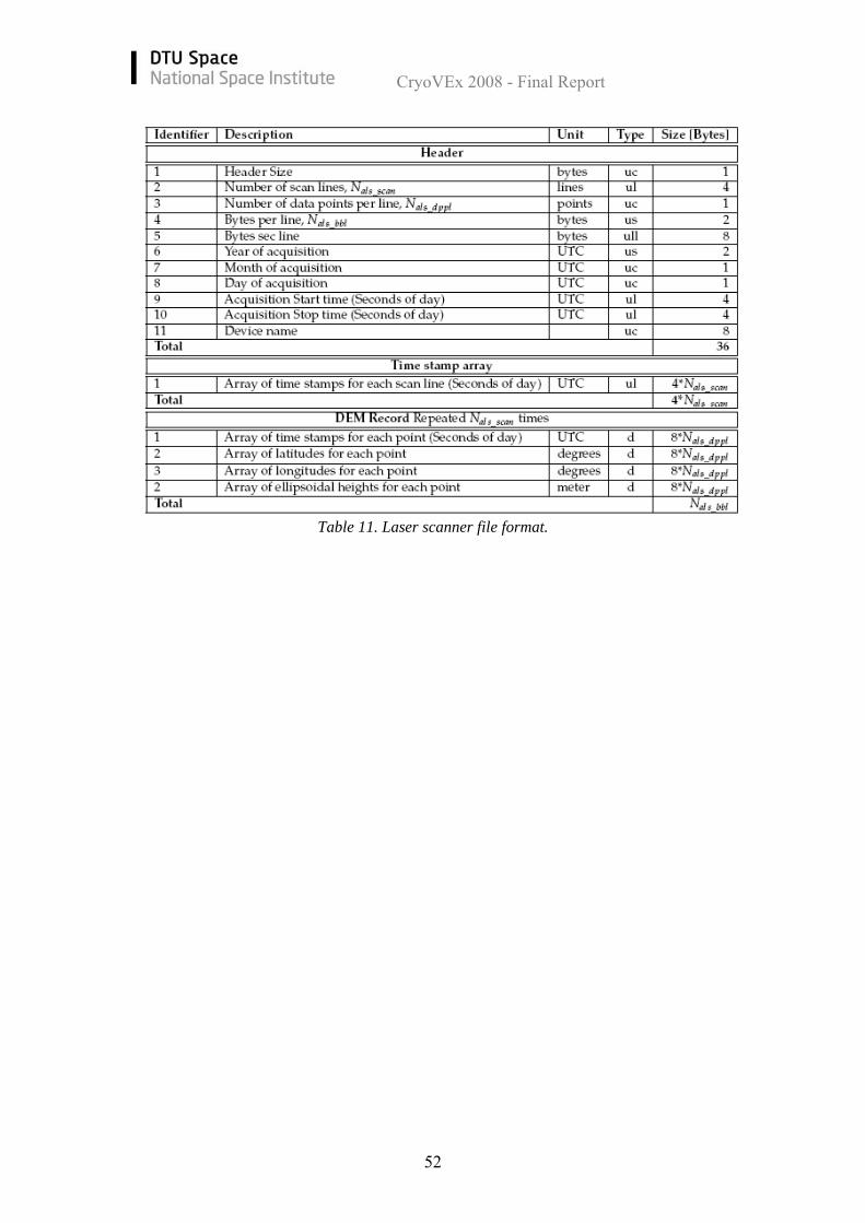
Table 10. INS file format. The processed laser scanner data is delivered in binary, little endian format with each record formatted as described in Table 11. Note that the time is decimal hours since the beginning of the day with respect to UTC time.
CryoVEx 2008 - Final Report
52
Table 11. Laser scanner file format.
CryoVEx 2008 - Final Report
53
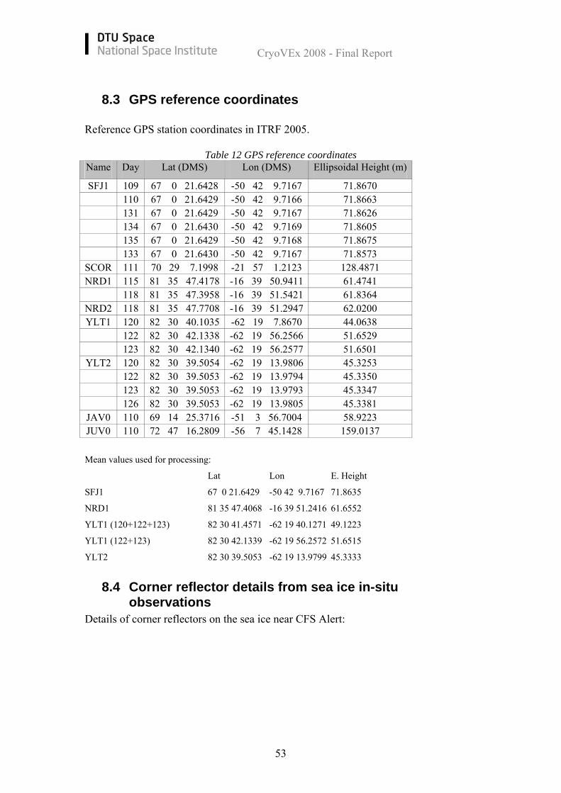
8.3 GPS reference coordinates Reference GPS station coordinates in ITRF 2005.
Table 12 GPS reference coordinates Name Day Lat (DMS) Lon (DMS) Ellipsoidal Height (m)
SFJ1 109 67 0 21.6428 -50 42 9.7167 71.8670 110 67 0 21.6429 -50 42 9.7166 71.8663 131 67 0 21.6429 -50 42 9.7167 71.8626 134 67 0 21.6430 -50 42 9.7169 71.8605 135 67 0 21.6429 -50 42 9.7168 71.8675 133 67 0 21.6430 -50 42 9.7167 71.8573
SCOR 111 70 29 7.1998 -21 57 1.2123 128.4871 NRD1 115 81 35 47.4178 -16 39 50.9411 61.4741
118 81 35 47.3958 -16 39 51.5421 61.8364 NRD2 118 81 35 47.7708 -16 39 51.2947 62.0200 YLT1 120 82 30 40.1035 -62 19 7.8670 44.0638
122 82 30 42.1338 -62 19 56.2566 51.6529 123 82 30 42.1340 -62 19 56.2577 51.6501
YLT2 120 82 30 39.5054 -62 19 13.9806 45.3253 122 82 30 39.5053 -62 19 13.9794 45.3350 123 82 30 39.5053 -62 19 13.9793 45.3347 126 82 30 39.5053 -62 19 13.9805 45.3381
JAV0 110 69 14 25.3716 -51 3 56.7004 58.9223 JUV0 110 72 47 16.2809 -56 7 45.1428 159.0137
Mean values used for processing:
Lat Lon E. Height
SFJ1 67 0 21.6429 -50 42 9.7167 71.8635
NRD1 81 35 47.4068 -16 39 51.2416 61.6552
YLT1 (120+122+123) 82 30 41.4571 -62 19 40.1271 49.1223
YLT1 (122+123) 82 30 42.1339 -62 19 56.2572 51.6515
YLT2 82 30 39.5053 -62 19 13.9799 45.3333
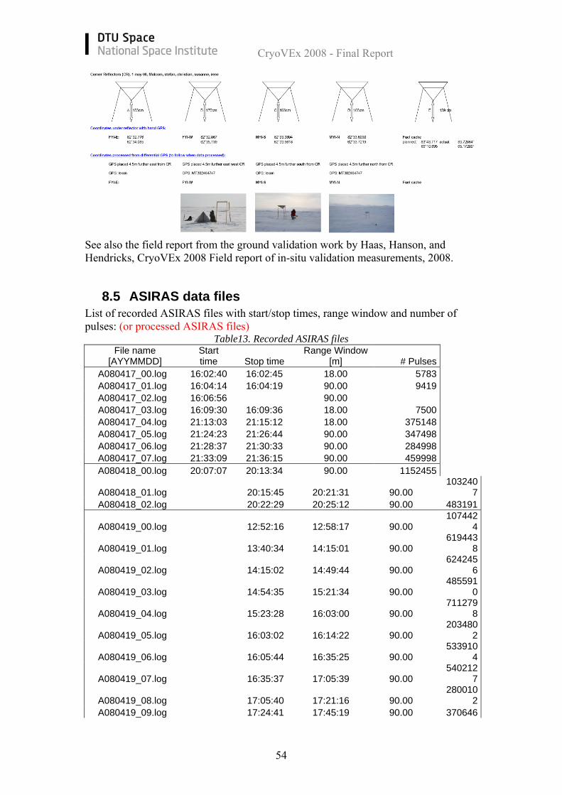
8.4 Corner reflector details from sea ice in-situ observations
Details of corner reflectors on the sea ice near CFS Alert:
CryoVEx 2008 - Final Report
54
See also the field report from the ground validation work by Haas, Hanson, and Hendricks, CryoVEx 2008 Field report of in-situ validation measurements, 2008.
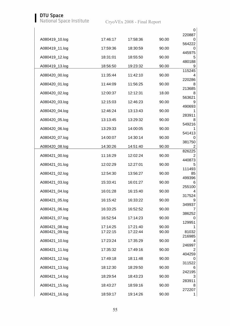
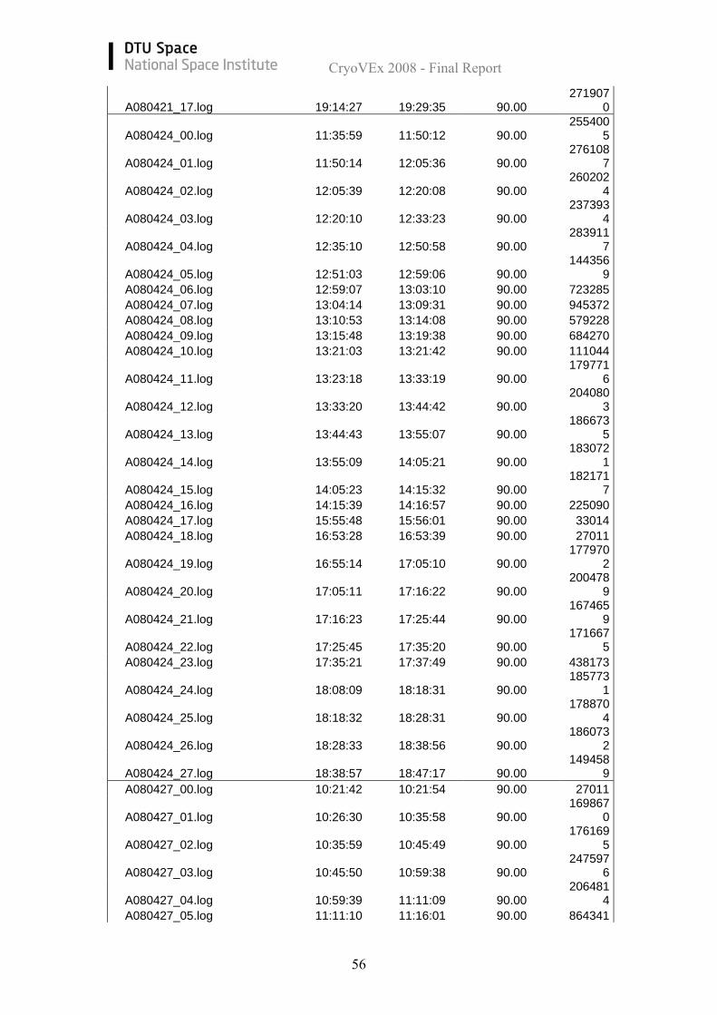
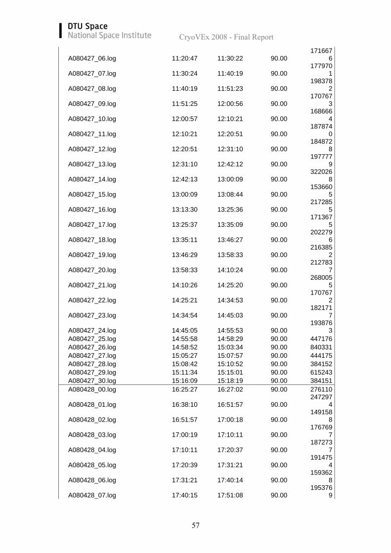
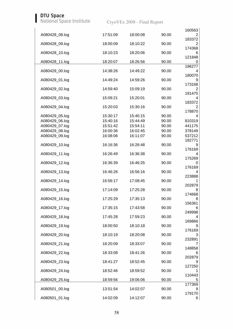
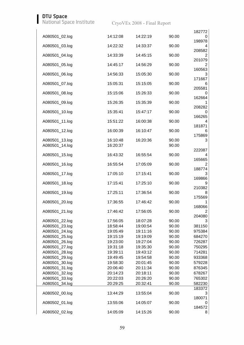
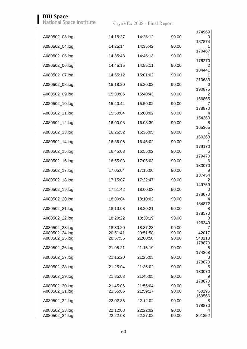
8.5 ASIRAS data files List of recorded ASIRAS files with start/stop times, range window and number of pulses: (or processed ASIRAS files)
Table13. Recorded ASIRAS files File name
[AYYMMDD] Start time Stop time
Range Window [m] # Pulses
A080417_00.log 16:02:40 16:02:45 18.00 5783 A080417_01.log 16:04:14 16:04:19 90.00 9419 A080417_02.log 16:06:56 90.00 A080417_03.log 16:09:30 16:09:36 18.00 7500 A080417_04.log 21:13:03 21:15:12 18.00 375148 A080417_05.log 21:24:23 21:26:44 90.00 347498 A080417_06.log 21:28:37 21:30:33 90.00 284998 A080417_07.log 21:33:09 21:36:15 90.00 459998 A080418_00.log 20:07:07 20:13:34 90.00 1152455
A080418_01.log 20:15:45 20:21:31 90.00 103240
7 A080418_02.log 20:22:29 20:25:12 90.00 483191
A080419_00.log 12:52:16 12:58:17 90.00 107442
4
A080419_01.log 13:40:34 14:15:01 90.00 619443
8
A080419_02.log 14:15:02 14:49:44 90.00 624245
6
A080419_03.log 14:54:35 15:21:34 90.00 485591
0
A080419_04.log 15:23:28 16:03:00 90.00 711279
8
A080419_05.log 16:03:02 16:14:22 90.00 203480
2
A080419_06.log 16:05:44 16:35:25 90.00 533910
4
A080419_07.log 16:35:37 17:05:39 90.00 540212
7
A080419_08.log 17:05:40 17:21:16 90.00 280010
2 A080419_09.log 17:24:41 17:45:19 90.00 370646
CryoVEx 2008 - Final Report
55
0
A080419_10.log 17:46:17 17:58:36 90.00 220887
0
A080419_11.log 17:59:36 18:30:59 90.00 564222
0
A080419_12.log 18:31:01 18:55:50 90.00 445975
5
A080419_13.log 18:56:50 19:23:32 90.00 480188
9
A080420_00.log 11:35:44 11:42:10 90.00 115245
4
A080420_01.log 11:44:09 11:56:25 90.00 220286
8
A080420_02.log 12:00:37 12:12:31 18.00 213685
8
A080420_03.log 12:15:03 12:46:23 90.00 563621
9
A080420_04.log 12:46:24 13:13:43 90.00 490693
1
A080420_05.log 13:13:45 13:29:32 90.00 283911
8
A080420_06.log 13:29:33 14:00:05 90.00 549216
1
A080420_07.log 14:00:07 14:30:14 90.00 541413
0
A080420_08.log 14:30:26 14:51:40 90.00 381750
2
A080421_00.log 11:16:29 12:02:24 90.00 826225
2
A080421_01.log 12:02:29 12:27:01 90.00 440873
5
A080421_02.log 12:54:30 13:56:27 90.00 111493
85
A080421_03.log 15:33:41 16:01:27 90.00 499396
6
A080421_04.log 16:01:28 16:15:40 90.00 255100
4
A080421_05.log 16:15:42 16:33:22 90.00 317524
9
A080421_06.log 16:33:25 16:52:52 90.00 349937
7
A080421_07.log 16:52:54 17:14:23 90.00 386252
0
A080421_08.log 17:14:25 17:21:40 90.00 129951
1 A080421_09.log 17:22:15 17:22:44 90.00 81032
A080421_10.log 17:23:24 17:35:29 90.00 216985
4
A080421_11.log 17:35:32 17:49:16 90.00 246997
2
A080421_12.log 17:49:18 18:11:48 90.00 404259
0
A080421_13.log 18:12:30 18:29:50 90.00 311522
6
A080421_14.log 18:29:54 18:43:23 90.00 242195
3
A080421_15.log 18:43:27 18:59:16 90.00 283911
8
A080421_16.log 18:59:17 19:14:26 90.00 272207
1
CryoVEx 2008 - Final Report
56
A080421_17.log 19:14:27 19:29:35 90.00 271907
0
A080424_00.log 11:35:59 11:50:12 90.00 255400
5
A080424_01.log 11:50:14 12:05:36 90.00 276108
7
A080424_02.log 12:05:39 12:20:08 90.00 260202
4
A080424_03.log 12:20:10 12:33:23 90.00 237393
4
A080424_04.log 12:35:10 12:50:58 90.00 283911
7
A080424_05.log 12:51:03 12:59:06 90.00 144356
9 A080424_06.log 12:59:07 13:03:10 90.00 723285 A080424_07.log 13:04:14 13:09:31 90.00 945372 A080424_08.log 13:10:53 13:14:08 90.00 579228 A080424_09.log 13:15:48 13:19:38 90.00 684270 A080424_10.log 13:21:03 13:21:42 90.00 111044
A080424_11.log 13:23:18 13:33:19 90.00 179771
6
A080424_12.log 13:33:20 13:44:42 90.00 204080
3
A080424_13.log 13:44:43 13:55:07 90.00 186673
5
A080424_14.log 13:55:09 14:05:21 90.00 183072
1
A080424_15.log 14:05:23 14:15:32 90.00 182171
7 A080424_16.log 14:15:39 14:16:57 90.00 225090 A080424_17.log 15:55:48 15:56:01 90.00 33014 A080424_18.log 16:53:28 16:53:39 90.00 27011
A080424_19.log 16:55:14 17:05:10 90.00 177970
2
A080424_20.log 17:05:11 17:16:22 90.00 200478
9
A080424_21.log 17:16:23 17:25:44 90.00 167465
9
A080424_22.log 17:25:45 17:35:20 90.00 171667
5 A080424_23.log 17:35:21 17:37:49 90.00 438173
A080424_24.log 18:08:09 18:18:31 90.00 185773
1
A080424_25.log 18:18:32 18:28:31 90.00 178870
4
A080424_26.log 18:28:33 18:38:56 90.00 186073
2
A080424_27.log 18:38:57 18:47:17 90.00 149458
9 A080427_00.log 10:21:42 10:21:54 90.00 27011
A080427_01.log 10:26:30 10:35:58 90.00 169867
0
A080427_02.log 10:35:59 10:45:49 90.00 176169
5
A080427_03.log 10:45:50 10:59:38 90.00 247597
6
A080427_04.log 10:59:39 11:11:09 90.00 206481
4 A080427_05.log 11:11:10 11:16:01 90.00 864341
CryoVEx 2008 - Final Report
57
A080427_06.log 11:20:47 11:30:22 90.00 171667
6
A080427_07.log 11:30:24 11:40:19 90.00 177970
1
A080427_08.log 11:40:19 11:51:23 90.00 198378
2
A080427_09.log 11:51:25 12:00:56 90.00 170767
3
A080427_10.log 12:00:57 12:10:21 90.00 168666
4
A080427_11.log 12:10:21 12:20:51 90.00 187874
0
A080427_12.log 12:20:51 12:31:10 90.00 184872
8
A080427_13.log 12:31:10 12:42:12 90.00 197777
9
A080427_14.log 12:42:13 13:00:09 90.00 322026
8
A080427_15.log 13:00:09 13:08:44 90.00 153660
5
A080427_16.log 13:13:30 13:25:36 90.00 217285
5
A080427_17.log 13:25:37 13:35:09 90.00 171367
5
A080427_18.log 13:35:11 13:46:27 90.00 202279
6
A080427_19.log 13:46:29 13:58:33 90.00 216385
2
A080427_20.log 13:58:33 14:10:24 90.00 212783
7
A080427_21.log 14:10:26 14:25:20 90.00 268005
5
A080427_22.log 14:25:21 14:34:53 90.00 170767
2
A080427_23.log 14:34:54 14:45:03 90.00 182171
7
A080427_24.log 14:45:05 14:55:53 90.00 193876
3 A080427_25.log 14:55:58 14:58:29 90.00 447176 A080427_26.log 14:58:52 15:03:34 90.00 840331 A080427_27.log 15:05:27 15:07:57 90.00 444175 A080427_28.log 15:08:42 15:10:52 90.00 384152 A080427_29.log 15:11:34 15:15:01 90.00 615243 A080427_30.log 15:16:09 15:18:19 90.00 384151 A080428_00.log 16:25:27 16:27:02 90.00 276110
A080428_01.log 16:38:10 16:51:57 90.00 247297
4
A080428_02.log 16:51:57 17:00:18 90.00 149158
8
A080428_03.log 17:00:19 17:10:11 90.00 176769
7
A080428_04.log 17:10:11 17:20:37 90.00 187273
7
A080428_05.log 17:20:39 17:31:21 90.00 191475
4
A080428_06.log 17:31:21 17:40:14 90.00 159362
8
A080428_07.log 17:40:15 17:51:08 90.00 195376
9
CryoVEx 2008 - Final Report
58
A080428_08.log 17:51:09 18:00:08 90.00 160563
2
A080428_09.log 18:00:09 18:10:22 90.00 183372
2
A080428_10.log 18:10:23 18:20:06 90.00 174368
6
A080428_11.log 18:20:07 18:26:56 90.00 121848
0
A080429_00.log 14:38:26 14:49:22 90.00 196277
4
A080429_01.log 14:49:24 14:59:26 90.00 180070
9
A080429_02.log 14:59:40 15:09:19 90.00 173168
2
A080429_03.log 15:09:21 15:20:01 90.00 191475
4
A080429_04.log 15:20:03 15:30:16 90.00 183372
2
A080429_05.log 15:30:17 15:40:15 90.00 178870
4 A080429_06.log 15:40:16 15:44:49 90.00 810319 A080429_07.log 15:51:42 15:54:11 90.00 441175 A080429_08.log 16:00:36 16:02:45 90.00 378149 A080429_09.log 16:08:06 16:11:07 90.00 537212
A080429_10.log 16:16:36 16:26:48 90.00 182771
9
A080429_11.log 16:26:49 16:36:38 90.00 176169
4
A080429_12.log 16:36:39 16:46:25 90.00 175269
0
A080429_13.log 16:46:26 16:56:16 90.00 176169
4
A080429_14.log 16:56:17 17:08:45 90.00 223888
1
A080429_15.log 17:14:09 17:25:28 90.00 202879
8
A080429_16.log 17:25:29 17:35:13 90.00 174668
8
A080429_17.log 17:35:15 17:43:58 90.00 156361
6
A080429_18.log 17:45:28 17:59:23 90.00 249998
4
A080429_19.log 18:00:50 18:10:18 90.00 169866
9
A080429_20.log 18:10:19 18:20:08 90.00 176169
3
A080429_21.log 18:20:09 18:33:07 90.00 232891
7
A080429_22.log 18:33:08 18:41:26 90.00 148858
6
A080429_23.log 18:41:27 18:52:45 90.00 202879
9
A080429_24.log 18:52:46 18:59:52 90.00 127250
1
A080429_25.log 18:59:56 19:06:06 90.00 110443
5
A080501_00.log 13:51:54 14:02:07 90.00 177369
9
A080501_01.log 14:02:09 14:12:07 90.00 179170
6
CryoVEx 2008 - Final Report
59
A080501_02.log 14:12:08 14:22:19 90.00 182772
0
A080501_03.log 14:22:32 14:33:37 90.00 198978
4
A080501_04.log 14:33:39 14:45:15 90.00 208582
2
A080501_05.log 14:45:17 14:56:29 90.00 201079
2
A080501_06.log 14:56:33 15:05:30 90.00 160563
3
A080501_07.log 15:05:31 15:15:05 90.00 171667
6
A080501_08.log 15:15:06 15:26:33 90.00 205581
0
A080501_09.log 15:26:35 15:35:39 90.00 162664
1
A080501_10.log 15:35:41 15:47:17 90.00 208282
0
A080501_11.log 15:51:22 16:00:38 90.00 166265
4
A080501_12.log 16:00:39 16:10:47 90.00 181871
6
A080501_13.log 16:10:48 16:20:36 90.00 175869
3 A080501_14.log 16:20:37 90.00
A080501_15.log 16:43:32 16:55:54 90.00 222087
4
A080501_16.log 16:55:54 17:05:09 90.00 165665
2
A080501_17.log 17:05:10 17:15:41 90.00 188774
3
A080501_18.log 17:15:41 17:25:10 90.00 169866
9
A080501_19.log 17:25:11 17:36:54 90.00 210382
8
A080501_20.log 17:36:55 17:46:42 90.00 175569
1
A080501_21.log 17:46:42 17:56:05 90.00 168066
2
A080501_22.log 17:56:05 18:07:28 90.00 204080
3 A080501_23.log 18:58:44 19:00:54 90.00 381150 A080501_24.log 19:05:49 19:11:16 90.00 975384 A080501_25.log 19:15:19 19:19:09 90.00 684270 A080501_26.log 19:23:00 19:27:04 90.00 726287 A080501_27.log 19:31:18 19:35:30 90.00 750295 A080501_28.log 19:39:11 19:43:12 90.00 714281 A080501_29.log 19:49:45 19:54:58 90.00 933368 A080501_30.log 19:58:30 20:01:45 90.00 579228 A080501_31.log 20:06:40 20:11:34 90.00 876345 A080501_32.log 20:14:23 20:18:11 90.00 678267 A080501_33.log 20:22:03 20:26:20 90.00 765302 A080501_34.log 20:29:25 20:32:41 90.00 582230
A080502_00.log 13:44:29 13:55:04 90.00 183372
3
A080502_01.log 13:55:06 14:05:07 90.00 180071
0
A080502_02.log 14:05:09 14:15:26 90.00 184572
8
CryoVEx 2008 - Final Report
60
A080502_03.log 14:15:27 14:25:12 90.00 174969
0
A080502_04.log 14:25:14 14:35:42 90.00 187874
1
A080502_05.log 14:35:43 14:45:13 90.00 170467
1
A080502_06.log 14:45:15 14:55:11 90.00 178270
2
A080502_07.log 14:55:12 15:01:02 90.00 104441
1
A080502_08.log 15:18:20 15:30:03 90.00 210683
0
A080502_09.log 15:30:05 15:40:43 90.00 190875
2
A080502_10.log 15:40:44 15:50:02 90.00 166865
7
A080502_11.log 15:50:04 16:00:02 90.00 178870
4
A080502_12.log 16:00:03 16:08:39 90.00 154260
8
A080502_13.log 16:26:52 16:36:05 90.00 165365
1
A080502_14.log 16:36:06 16:45:02 90.00 160263
1
A080502_15.log 16:45:03 16:55:02 90.00 179170
6
A080502_16.log 16:55:03 17:05:03 90.00 179470
6
A080502_17.log 17:05:04 17:15:06 90.00 180070
9
A080502_18.log 17:15:07 17:22:47 90.00 137454
2
A080502_19.log 17:51:42 18:00:03 90.00 149759
0
A080502_20.log 18:00:04 18:10:02 90.00 178870
4
A080502_21.log 18:10:03 18:20:21 90.00 184872
8
A080502_22.log 18:20:22 18:30:19 90.00 178570
3
A080502_23.log 18:30:20 18:37:23 90.00 126349
7 A080502_24.log 20:51:41 20:51:58 90.00 42017 A080502_25.log 20:57:56 21:00:58 90.00 540213
A080502_26.log 21:05:21 21:15:19 90.00 178870
5
A080502_27.log 21:15:20 21:25:03 90.00 174368
8
A080502_28.log 21:25:04 21:35:02 90.00 178870
5
A080502_29.log 21:35:03 21:45:05 90.00 180070
9
A080502_30.log 21:45:06 21:55:04 90.00 178870
5 A080502_31.log 21:55:05 21:59:17 90.00 750296
A080502_32.log 22:02:35 22:12:02 90.00 169566
8
A080502_33.log 22:12:03 22:22:02 90.00 178870
4 A080502_34.log 22:22:03 22:27:02 90.00 891352
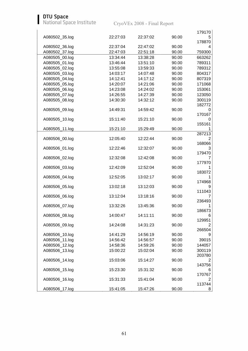
CryoVEx 2008 - Final Report
61
A080502_35.log 22:27:03 22:37:02 90.00 179170
5
A080502_36.log 22:37:04 22:47:02 90.00 178870
4 A080502_37.log 22:47:03 22:51:18 90.00 759300 A080505_00.log 13:34:44 13:38:28 90.00 663262 A080505_01.log 13:46:44 13:51:10 90.00 789311 A080505_02.log 13:55:08 13:59:33 90.00 789312 A080505_03.log 14:03:17 14:07:48 90.00 804317 A080505_04.log 14:12:41 14:17:12 90.00 807319 A080505_05.log 14:20:07 14:21:06 90.00 171068 A080505_06.log 14:23:08 14:24:02 90.00 153061 A080505_07.log 14:26:55 14:27:39 90.00 123050 A080505_08.log 14:30:30 14:32:12 90.00 300119
A080505_09.log 14:49:31 14:59:42 90.00 182772
0
A080505_10.log 15:11:40 15:21:10 90.00 170167
0
A080505_11.log 15:21:10 15:29:49 90.00 155161
1
A080506_00.log 12:05:40 12:22:44 90.00 287213
2
A080506_01.log 12:22:46 12:32:07 90.00 168066
3
A080506_02.log 12:32:08 12:42:08 90.00 179470
7
A080506_03.log 12:42:09 12:52:04 90.00 177970
1
A080506_04.log 12:52:05 13:02:17 90.00 183072
1
A080506_05.log 13:02:18 13:12:03 90.00 174968
9
A080506_06.log 13:12:04 13:18:16 90.00 111043
7
A080506_07.log 13:32:26 13:45:36 90.00 236493
1
A080506_08.log 14:00:47 14:11:11 90.00 186673
6
A080506_09.log 14:24:08 14:31:23 90.00 129951
2
A080506_10.log 14:41:29 14:56:19 90.00 266504
9 A080506_11.log 14:56:42 14:56:57 90.00 39015 A080506_12.log 14:58:36 14:59:26 90.00 144057 A080506_13.log 15:00:22 15:02:04 90.00 300119
A080506_14.log 15:03:06 15:14:27 90.00 203780
2
A080506_15.log 15:23:30 15:31:32 90.00 143756
6
A080506_16.log 15:31:33 15:41:04 90.00 170767
2
A080506_17.log 15:41:05 15:47:26 90.00 113744
8
CryoVEx 2008 - Final Report
62
8.6 Processed ASIRAS profiles Following plots show all processed ASIRAS profiles. Each profile plot consists of four parts.
1. Header composed of daily profile number and the date and a sub-header with the filename.
2. Geographical plot of the profile (diamond indicates the start of the profile) 3. Rough indication of the height as determined by the OCOG retracker plotted
versus time of day in seconds. 4. Info box with date, start and stop times in hour, minute, seconds, and in square
brackets seconds of the day, acquisition mode etc. It should be emphasized that the surface height determined by the OCOG retracker is a rough estimate and not a true height.