Embed Size (px)
Citation preview
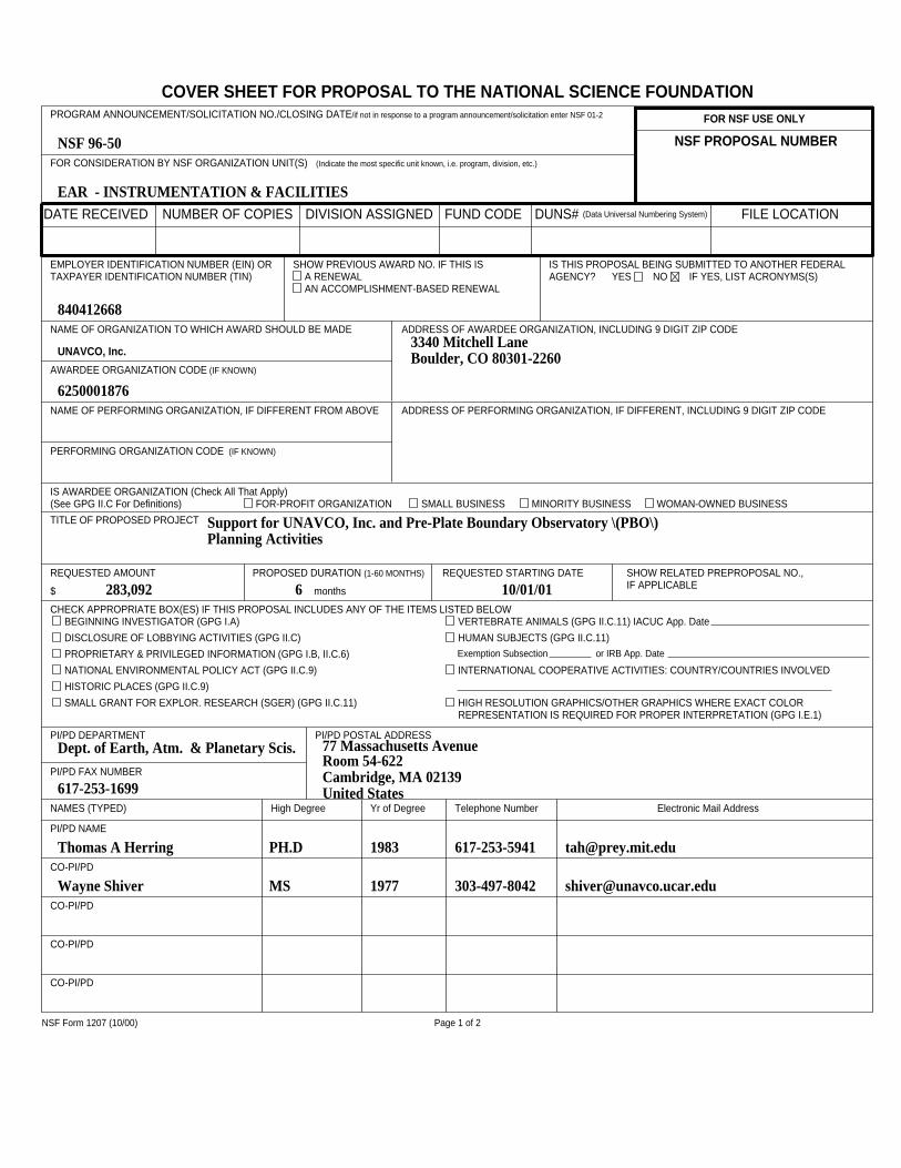
COVER SHEET FOR PROPOSAL TO THE NATIONAL SCIENCE FOUNDATIONFOR NSF USE ONLY
NSF PROPOSAL NUMBER
DATE RECEIVED NUMBER OF COPIES DIVISION ASSIGNED FUND CODE DUNS# (Data Universal Numbering System) FILE LOCATION
FOR CONSIDERATION BY NSF ORGANIZATION UNIT(S) (Indicate the most specific unit known, i.e. program, division, etc.)
PROGRAM ANNOUNCEMENT/SOLICITATION NO./CLOSING DATE/if not in response to a program announcement/solicitation enter NSF 01-2
EMPLOYER IDENTIFICATION NUMBER (EIN) ORTAXPAYER IDENTIFICATION NUMBER (TIN)
SHOW PREVIOUS AWARD NO. IF THIS ISA RENEWALAN ACCOMPLISHMENT-BASED RENEWAL
IS THIS PROPOSAL BEING SUBMITTED TO ANOTHER FEDERALAGENCY? YES NO IF YES, LIST ACRONYMS(S)
NAME OF ORGANIZATION TO WHICH AWARD SHOULD BE MADE ADDRESS OF AWARDEE ORGANIZATION, INCLUDING 9 DIGIT ZIP CODE
AWARDEE ORGANIZATION CODE (IF KNOWN)
IS AWARDEE ORGANIZATION (Check All That Apply)(See GPG II.C For Definitions) FOR-PROFIT ORGANIZATION SMALL BUSINESS MINORITY BUSINESS WOMAN-OWNED BUSINESS
NAME OF PERFORMING ORGANIZATION, IF DIFFERENT FROM ABOVE ADDRESS OF PERFORMING ORGANIZATION, IF DIFFERENT, INCLUDING 9 DIGIT ZIP CODE
PERFORMING ORGANIZATION CODE (IF KNOWN)
TITLE OF PROPOSED PROJECT
REQUESTED AMOUNT
$
PROPOSED DURATION (1-60 MONTHS)
months
REQUESTED STARTING DATE SHOW RELATED PREPROPOSAL NO.,IF APPLICABLE
CHECK APPROPRIATE BOX(ES) IF THIS PROPOSAL INCLUDES ANY OF THE ITEMS LISTED BELOWBEGINNING INVESTIGATOR (GPG I.A)
DISCLOSURE OF LOBBYING ACTIVITIES (GPG II.C)
PROPRIETARY & PRIVILEGED INFORMATION (GPG I.B, II.C.6)
NATIONAL ENVIRONMENTAL POLICY ACT (GPG II.C.9)
HISTORIC PLACES (GPG II.C.9)
SMALL GRANT FOR EXPLOR. RESEARCH (SGER) (GPG II.C.11)
VERTEBRATE ANIMALS (GPG II.C.11) IACUC App. Date
HUMAN SUBJECTS (GPG II.C.11)Exemption Subsection or IRB App. Date
INTERNATIONAL COOPERATIVE ACTIVITIES: COUNTRY/COUNTRIES INVOLVED
HIGH RESOLUTION GRAPHICS/OTHER GRAPHICS WHERE EXACT COLORREPRESENTATION IS REQUIRED FOR PROPER INTERPRETATION (GPG I.E.1)
PI/PD DEPARTMENT PI/PD POSTAL ADDRESS
PI/PD FAX NUMBER
NAMES (TYPED) High Degree Yr of Degree Telephone Number Electronic Mail Address
PI/PD NAME
CO-PI/PD
CO-PI/PD
CO-PI/PD
CO-PI/PD
NSF Form 1207 (10/00) Page 1 of 2
EAR - INSTRUMENTATION & FACILITIES
NSF 96-50
840412668
UNAVCO, Inc.
6250001876
3340 Mitchell LaneBoulder, CO 80301-2260
Support for UNAVCO, Inc. and Pre-Plate Boundary Observatory \(PBO\) Planning Activities
283,092 6 10/01/01
Dept. of Earth, Atm. & Planetary Scis.
617-253-1699
77 Massachusetts AvenueRoom 54-622Cambridge, MA 02139United States
Thomas A Herring PH.D 1983 617-253-5941 [email protected]
Wayne Shiver MS 1977 303-497-8042 [email protected]
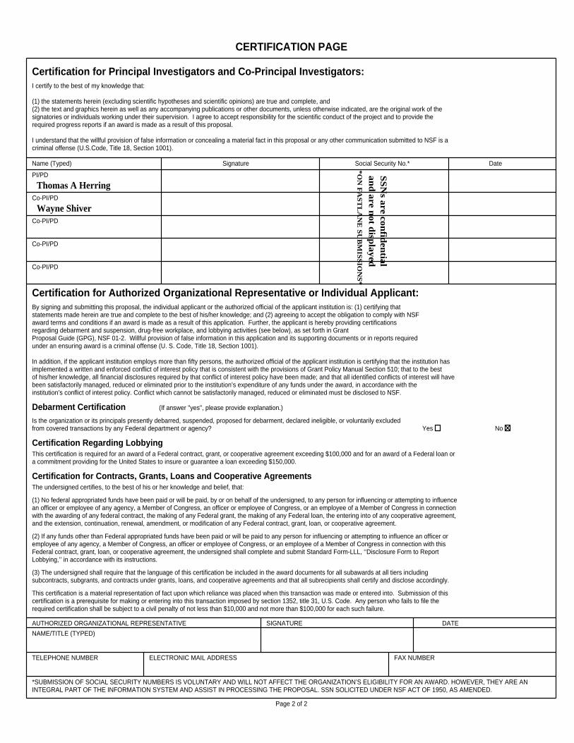
CERTIFICATION PAGE
Certification for Principal Investigators and Co-Principal Investigators:I certify to the best of my knowledge that: (1) the statements herein (excluding scientific hypotheses and scientific opinions) are true and complete, and(2) the text and graphics herein as well as any accompanying publications or other documents, unless otherwise indicated, are the original work of thesignatories or individuals working under their supervision. I agree to accept responsibility for the scientific conduct of the project and to provide therequired progress reports if an award is made as a result of this proposal. I understand that the willful provision of false information or concealing a material fact in this proposal or any other communication submitted to NSF is acriminal offense (U.S.Code, Title 18, Section 1001).
Name (Typed) Signature Social Security No.* Date
PI/PD
Co-PI/PD
Co-PI/PD
Co-PI/PD
Co-PI/PD
Certification for Authorized Organizational Representative or Individual Applicant:By signing and submitting this proposal, the individual applicant or the authorized official of the applicant institution is: (1) certifying thatstatements made herein are true and complete to the best of his/her knowledge; and (2) agreeing to accept the obligation to comply with NSFaward terms and conditions if an award is made as a result of this application. Further, the applicant is hereby providing certificationsregarding debarment and suspension, drug-free workplace, and lobbying activities (see below), as set forth in GrantProposal Guide (GPG), NSF 01-2. Willful provision of false information in this application and its supporting documents or in reports requiredunder an ensuring award is a criminal offense (U. S. Code, Title 18, Section 1001). In addition, if the applicant institution employs more than fifty persons, the authorized official of the applicant institution is certifying that the institution has implemented a written and enforced conflict of interest policy that is consistent with the provisions of Grant Policy Manual Section 510; that to the bestof his/her knowledge, all financial disclosures required by that conflict of interest policy have been made; and that all identified conflicts of interest will havebeen satisfactorily managed, reduced or eliminated prior to the institution’s expenditure of any funds under the award, in accordance with theinstitution’s conflict of interest policy. Conflict which cannot be satisfactorily managed, reduced or eliminated must be disclosed to NSF.
Debarment Certification (If answer "yes", please provide explanation.)
Is the organization or its principals presently debarred, suspended, proposed for debarment, declared ineligible, or voluntarily excluded from covered transactions by any Federal department or agency? Yes No
Certification Regarding LobbyingThis certification is required for an award of a Federal contract, grant, or cooperative agreement exceeding $100,000 and for an award of a Federal loan ora commitment providing for the United States to insure or guarantee a loan exceeding $150,000.
Certification for Contracts, Grants, Loans and Cooperative AgreementsThe undersigned certifies, to the best of his or her knowledge and belief, that:
(1) No federal appropriated funds have been paid or will be paid, by or on behalf of the undersigned, to any person for influencing or attempting to influencean officer or employee of any agency, a Member of Congress, an officer or employee of Congress, or an employee of a Member of Congress in connectionwith the awarding of any federal contract, the making of any Federal grant, the making of any Federal loan, the entering into of any cooperative agreement,and the extension, continuation, renewal, amendment, or modification of any Federal contract, grant, loan, or cooperative agreement.
(2) If any funds other than Federal appropriated funds have been paid or will be paid to any person for influencing or attempting to influence an officer oremployee of any agency, a Member of Congress, an officer or employee of Congress, or an employee of a Member of Congress in connection with thisFederal contract, grant, loan, or cooperative agreement, the undersigned shall complete and submit Standard Form-LLL, ‘‘Disclosure Form to ReportLobbying,’’ in accordance with its instructions.
(3) The undersigned shall require that the language of this certification be included in the award documents for all subawards at all tiers includingsubcontracts, subgrants, and contracts under grants, loans, and cooperative agreements and that all subrecipients shall certify and disclose accordingly.
This certification is a material representation of fact upon which reliance was placed when this transaction was made or entered into. Submission of thiscertification is a prerequisite for making or entering into this transaction imposed by section 1352, title 31, U.S. Code. Any person who fails to file therequired certification shall be subject to a civil penalty of not less than $10,000 and not more than $100,000 for each such failure.
AUTHORIZED ORGANIZATIONAL REPRESENTATIVE SIGNATURE DATE
NAME/TITLE (TYPED)
TELEPHONE NUMBER ELECTRONIC MAIL ADDRESS FAX NUMBER
*SUBMISSION OF SOCIAL SECURITY NUMBERS IS VOLUNTARY AND WILL NOT AFFECT THE ORGANIZATION’S ELIGIBILITY FOR AN AWARD. HOWEVER, THEY ARE ANINTEGRAL PART OF THE INFORMATION SYSTEM AND ASSIST IN PROCESSING THE PROPOSAL. SSN SOLICITED UNDER NSF ACT OF 1950, AS AMENDED.
Page 2 of 2
Thomas A HerringS
SN
s are confid
ential
and
are not d
isplayed
*ON
FA
ST
LA
NE
SU
BM
ISS
ION
S*
Wayne Shiver
A. Project Summary
The University NAVSTAR Consortium (UNAVCO) was created in 1984 to secure very expensive GlobalPositioning System (GPS) equipment for community use in geophysical research. In the intervening years, themembership of UNAVCO has grown from a handful of universities to over 100 international institutions engaged inpromoting and enhancing the use of GPS for multi-disciplinary Earth sciences research. A Facility was establishedto support Principal Investigators using GPS, to test and develop new technology enhancements, and to archive dataand data products for future studies. The explosive growth in applications of GPS, in addition to its increasedprecision, have brought the user community to the edge of new possibilities including the proposed Plate BoundaryObservatory (PBO). PBO is envisioned as a facility that would create a four-dimensional image of plate boundarydeformation across the western US over a broad range of temporal and spatial scales in unprecedented detail usingGPS and strainmeter techniques. This opportunity builds on previous success in a wide range of GPS and strainapplications including studies of earthquake dynamics, plate motion and associated modeling, postglacial reboundand constraints on viscosity structure, global mass redistribution, volcanic processes and many others. Thesesuccesses are due to the hard work and ingenuity of many community Principal Investigators (PIs) assisted by theequipment, engineers, technology developments, software tools, data processing techniques, global infrastructure,and data/data products made available by UNAVCO.
The UNAVCO community has, however, historically operated in a somewhat distributed business mode with aloosely-affiliated membership, multiple centers of technical development and facilities support, and leadershipprovided through an elected Steering Committee and appointment of a Scientific Director. The primary UNAVCOFacility has always been operated indirectly by host institutions such as the University of Colorado and theUniversity Corporation for Atmospheric Research (UCAR). The fact that the primary UNAVCO grant passedthrough these host institutions implies an indirect control of funds and resources by the primary architects ofUNAVCO. There is now a broad community consensus that UNAVCO must formalize its status as an independentnonprofit research organization and that future grants for activities such as operation of GPS facilities and the PBOshould pass directly to UNAVCO. In addition, the community desires that the focus of UNAVCO be broadenedbeyond just GPS. Accordingly, the community has created a Colorado nonprofit research organization calledUNAVCO, Inc. whose new mission is to advance high-precision geodetic and strain techniques such as GPS.
This proposal is the first request for National Science Foundation (NSF) support of UNAVCO, Inc. activitiesincluding an interim President and several pre-PBO planning activities previously reviewed and approved by theEarthScope Working Group. The plan proposed is for UNAVCO, Inc. to operate with a part time President whostays affiliated with his host institution while a search for a full time President is conducted. Based on the outcomeof that search, UNAVCO, Inc. will submit a follow-on proposal for support of the President and a small office inWashington, D.C. The President s responsibilities will include, among others, those currently filled by theScientific Director. The goal is greater control of resources and priorities for the community, increased cost-effectiveness of operations, and the ability to meet the community-mandated management responsibilities for PBO.UNAVCO, Inc. understands it has many legal, contractual and financial responsibilities to meet in order to succeedin this important first step and we very much view it as a collaboration between the community represented byUNAVCO, Inc. and the NSF Division of Earth Sciences.
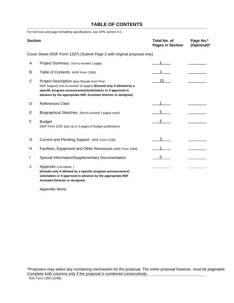
TABLE OF CONTENTSFor font size and page formatting specifications, see GPG section II.C.
Section Total No. of Page No.*Pages in Section (Optional)*
Cover Sheet (NSF Form 1207) (Submit Page 2 with original proposal only)
A Project Summary (not to exceed 1 page)
B Table of Contents (NSF Form 1359)
C Project Description (plus Results from Prior
NSF Support) (not to exceed 15 pages) (Exceed only if allowed by aspecific program announcement/solicitation or if approved inadvance by the appropriate NSF Assistant Director or designee)
D References Cited
E Biographical Sketches (Not to exceed 2 pages each)
F Budget (NSF Form 1030, plus up to 3 pages of budget justification)
G Current and Pending Support (NSF Form 1239)
H Facilities, Equipment and Other Resources (NSF Form 1363)
I Special Information/Supplementary Documentation
J Appendix (List below. )
(Include only if allowed by a specific program announcement/solicitation or if approved in advance by the appropriate NSFAssistant Director or designee)
Appendix Items:
*Proposers may select any numbering mechanism for the proposal. The entire proposal however, must be paginated.Complete both columns only if the proposal is numbered consecutively.
NSF Form 1359 (10/99)
1
1
15
1
5
5
3
1
0
C. Project Description
1. Background
a. History of UNAVCO
The creation of the University NAVSTAR Consortium (UNAVCO) grew out of the early possibilities afforded bythe Global Positioning System (GPS) to measure the movement of features on the Earth at unprecedented accuracy(cm’s) with a degree of speed and mobility not previously available with other space-based systems. Very LongBaseline Interferometry (VLBI), for example, measured points on the Earth relative to distant space bodies veryaccurately but required huge fixed antennas and sophisticated processing which limited its application to a fewdiscrete points spaced over the Earth. The major impediments to the use of GPS in its early days were obtaining thevery expensive receivers (~$250,000) needed to collect the data and then creating the infrastructure and techniquesto make the measurements with sufficient accuracy to meet the research goals of the geodesy and geophysicscommunity. The holy grail of the research community was to make cm-level measurements anywhere on the globe.If mobile GPS techniques could be developed with this level of accuracy, then the fields of earthquake study,volcano monitoring, measurement of glaciers and sea level change, and many other Earth science applications wouldexplode.
In 1984, a group of university Principal Investigators (PIs) wrote a proposal to the National Science Foundation(NSF) for funding of the first pool of GPS receivers requested by the U.S. Earth sciences research community. Theproposal was successful and the first three Texas Instruments model 4100 GPS receivers were purchased andUNAVCO was thereby created. The initial emphasis of the newly formed GPS consortium was to ensure theefficient and fair use of these very scarce receivers. To this end, a set of bylaws were enacted, a steering committeeto represent the broad user community was elected by the first members, and the beginnings of the UNAVCOFacility to assist researchers using the GPS equipment were created at the University of Colorado. The Facility wasmoved administratively under the University Corporation for Atmospheric Research (UCAR) in 1992 to improvethe organizational support available and to promote the atmospheric applications of GPS.
Since its inception in 1984, UNAVCO has grown from six member institutions to over 100 universities andlaboratories. Its primary focus was to support and promote the use of GPS for high-accuracy geosciences research.While UNAVCO in its early days focused on the beginnings of a GPS measurement capability on behalf of theuniversity community, many other groups were busy in developing precise GPS measurement techniques andapplications. The Jet Propulsion Laboratory (JPL) of the National Aeronautics and Space Administration (NASA)was instrumental in developing improved GPS receiver and data processing technology, in improving the globalinfrastructure including precise orbits for the GPS satellites, and in pioneering many of the early Earth scienceresearch applications through major GPS campaigns in South America and Asia. Groups at MIT and Scrippsdeveloped processing techniques still in widespread use. An international group, now called the International GPSService (IGS), banded together to implement the global network of continuously operating stations needed for veryprecise orbit determination and developed standards and techniques for the dissemination of the data to a globalaudience. With this improved infrastructure, measurements of increasing accuracy were being made, overincreasing baseline lengths, over a greater portion of the globe. The early results were simple vectors showingmotions over several years along faults and between major plates, but the door was opening to increasinglysophisticated models of the Earth relying on combined data sources including seismic, GPS, and other traditionalgeologic and geophysical data.
Meanwhile, the membership of UNAVCO grew through the 1990’s as more and more university PIs embraced theuse of GPS in their studies and GPS receivers became increasingly affordable and available. UNAVCO was a keyplayer in negotiating the increased capability and reduced price of GPS receivers with major vendors over the years,a key factor in the growth of research applications. The activities of the growing UNAVCO community and itsBoulder, Colorado Facility continued to be funded primarily by the NSF but there was growing interest on the partof NASA for a multi-agency funded GPS facility. Starting in the mid-1990’s, the UNAVCO Facility assumed fromJPL the responsibility for supporting NASA-funded PIs using GPS and started a multi-year collaboration with JPLto support the NASA GPS Global Network (GGN), which is a critical component of the IGS network. Likewise, theUNAVCO community became better organized and sophisticated in its activities including developing workinggroups, convening annual meetings, and development of advocacy materials such as posters and brochures.
With this background of accomplishments, the UNAVCO community undertook in the late 1990’s the major step oforganizing itself as a legally-constituted, independent entity, capable of receiving government funds directly. Theemerging scale of GPS-related activities and need of the community to have direct control of its funds and resourcesled to the creation in April 2001 of UNAVCO, Inc., a Colorado nonprofit corporation. This step was a lookbackward at history recognizing the need to evolve organizationally but it also looked forward to the responsibilitiesand opportunities afforded by the EarthScope initiative, specifically the Plate Boundary Observatory (PBO). Thisproposal is the first effort by UNAVCO, Inc., the descendant of the University NAVSTAR Consortium, to seekdirect funding support from the NSF to continue its mandate of promoting and applying GPS technology andcapability to understanding the dynamics of the Earth. UNAVCO, Inc. understands it has many legal, contractual,and financial responsibilities to meet in order to succeed in this important first step and we very much view it as acollaboration between the community represented by UNAVCO, Inc. and the NSF Division of Earth Sciences.
b. Examples of Prior Results - Geophysical Applications of GPS
UNAVCO Inc. was formed to advance the application of high precision geodetic and strain techniques such as GPSto scientific problems in Earth sciences. We present in this section a small selection of recent results obtained withGPS to highlight the types of problems that are being addressed by the UNAVCO community and to illustrate boththe capabilities of GPS and potential problems that can arise. Extensive prior results from GPS applications can befound in the 1999-2003 UNAVCO proposal to NSF that is available at the Web URLhttp://www.unavco.org/research_science/publications/proposals/nsfproposal2000.pdf. GPS is a system that allowsvery accurate position determination and measurement of the characteristics of the medium through which the GPSsignal propagate [see, for reviews, Segall and Davis, 1997; Herring, 1999]. The accuracy of the positionmeasurements and the averaging time needed to achieve this accuracy essentially determine the applicationsappropriate to GPS. In many cases, the desired measurement is the linear rate of change of the positions of pointsattached to the Earth, and from these velocities, rates of strain accumulation can be determined. In many locationsaround the world, secular rates of change have been measured with accuracies of 1 mm/yr or better. However, it isbecoming clear that in many places, secular motion does not provide a complete representation of the movements ofthe Earth’s crust. The most apparent deviations from secular motion are the co-seismic displacements that occurduring earthquakes, the postseismic transients that follow earthquakes, and episodic volcano deformation.
Whereas the measurement of secular motions with GPS is relatively straightforward, interpretation of non-secularvariations is much more difficult. The first-order question often is: does the transient represent signal or noise?One of the primary functions of UNAVCO Inc. is to disseminate information concerning the origins andinterpretations of non-secular variations in GPS measurements. This activity particularly focuses on those variationsthat fall into the noise category, e.g., GPS receiver and antenna failure modes and monument stability, and how theeffects of noise can be minimized. Such an undertaking is critical to future applications of GPS but I soften beyondthe scope of individual PIs. Addressing such fundamental questions is a primary reason for the existence of anorganization like UNAVCO, Inc. UNAVCO, Inc. will specifically undertake those tasks that facilitate theapplications of accurate deformation measurements to Earth science. Through the consortium structure it is possiblefor the community to share expertise in both the technical and scientific aspects of accurate deformation monitoring.
To make the point more specifically about what can be measured effectively with GPS, we summarize below severalvery recent scientific results from GPS that were made possible by the facilities, equipment, technology, andenhanced capabilities made possible by UNAVCO. These specific examples relate to earthquake dynamics, crustaldeformation associated with subduction, glacial rebound and constraints on viscosity structure, and volcanicprocesses.
Earthquake Dynamics; Izmit, Turkey; August 17, 1999.
One of the best geodetically measured earthquakes in recent years occurred near Izmit, Turkey on August 17, 1999.Reilinger et al. [2000] report on the initial results for both co-seismic and post-seismic deformations from thisearthquake and there have been numerous papers published since then with most of them making extensive use ofthe GPS results from the region. Fortunately, with this earthquake there were 10 continuous GPS sites installed incollaboration with UNAVCO operating in the region at the time of the earthquake and another 18 campaign GPSsites that were observed frequently enough after the earthquake to allow reliable determination of postseismic
deformation. The area was also well covered by Interferometric Synthetic Aperture Radar (InSAR) images beforeand after the earthquake. One of the geophysically interesting aspects of this earthquake is its relationship with theDuzce earthquake that occurred 87-days after Izmit.
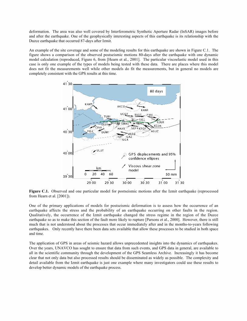
An example of the site coverage and some of the modeling results for this earthquake are shown in Figure C.1. Thefigure shows a comparison of the observed postseismic motions 80-days after the earthquake with one dynamicmodel calculation (reproduced, Figure 6, from [Hearn et al., 2001]. The particular viscoelastic model used in thiscase is only one example of the types of models being tested with these data. There are places where this modeldoes not fit the measurements well while other models do fit the measurements, but in general no models arecompletely consistent with the GPS results at this time.
Figure C.1. Observed and one particular model for postseismic motions after the Izmit earthquake (reprocessedfrom Hearn et al. [2001]).
One of the primary applications of models for postseismic deformation is to assess how the occurrence of anearthquake affects the stress and the probability of an earthquake occurring on other faults in the region.Qualitatively, the occurrence of the Izmit earthquake changed the stress regime in the region of the Duzceearthquake so as to make this section of the fault more likely to rupture [Parsons et al., 2000]. However, there is stillmuch that is not understood about the processes that occur immediately after and in the months-to-years followingearthquakes. Only recently have there been data sets available that allow these processes to be studied in both spaceand time.
The application of GPS in areas of seismic hazard allows unprecedented insights into the dynamics of earthquakes.Over the years, UNAVCO has sought to ensure that data from such events, and GPS data in general, are available toall in the scientific community through the development of the GPS Seamless Archive. Increasingly it has becomeclear that not only data but also processed results should be disseminated as widely as possible. The complexity anddetail available from the Izmit earthquake is just one example where many investigators could use these results todevelop better dynamic models of the earthquake process.
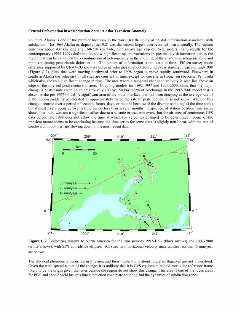
Crustal Deformation in a Subduction Zone; Alaska Transient Anomaly
Southern Alaska is one of the premier locations in the world for the study of crustal deformation associated withsubduction. The 1964 Alaska earthquake (Mw 9.2) was the second largest ever recorded instrumentally. The rupturezone was about 700 km long and 150-250 km wide, with an average slip of 15-20 meters. GPS results for thecontemporary (1992-1999) deformation show significant spatial variations in present-day deformation across theregion that can be explained by a combination of heterogeneity in the coupling of the shallow seismogenic zone andrapid continuing postseismic deformation. The pattern of deformation is not static in time. Fifteen survey-modeGPS sites supported by UNAVCO show a change in velocities of about 20-30 mm/year starting in early or mid-1998(Figure C.2). Sites that were moving northward prior to 1998 began to move rapidly southward. Elsewhere insouthern Alaska the velocities of all sites are constant in time, except for one site in Homer on the Kenai Peninsulawhich also shows a significant change in time. The area where a temporal change in velocity is seen lies above anedge of the inferred postseismic transient. Coupling models for 1992-1997 and 1997-2000, show that the majorchange is postseismic creep on an area roughly 100 by 150 km2 north of Anchorage in the 1997-2000 model that isabsent in the pre-1997 model. A significant area of the plate interface that had been creeping at the average rate ofplate motion suddenly accelerated to approximately twice the rate of plate motion. It is not known whether thischange occurred over a period of seconds, hours, days, or months because of the discrete sampling of the time seriesbut it most likely occurred over a time period less than several months. Inspection of station position time seriesshows that there was not a significant offset due to a seismic or aseismic event, but the absence of continuous GPSdata before late 1998 does not allow the time at which the velocities changed to be determined. Some of thetransient nature seems to be continuing because the time series for some sites is slightly non-linear, with the rate ofsouthward motion perhaps slowing down in the most recent data.
208˚
208˚
209˚
209˚
210˚
210˚
211˚
211˚
212˚
212˚
61˚ 61˚
62˚ 62˚
0 50
km
10 mm/year
20 mm/year
30 mm/year
Figure C.2. Velocities relative to North America for the time periods 1992-1997 (black arrows) and 1997-2000(white arrows), with 95% confidence ellipses. All sites with horizontal velocity uncertainties less than 5 mm/year
are shown.
The physical phenomena occurring in this area and their implications about future earthquakes are not understood.Given the wide spread nature of the change, it is unlikely that it is GPS equipment related, nor is the reference framelikely to be the origin given that sites outside the region do not show this change. This area is one of the focus areasfor PBO and should yield insights into subduction zone plate coupling and the dynamics of subduction zones.
Glacial Rebound and Constraints on Viscosity Structure
The enormous ice sheets of the last glacial period left their imprint throughout northern North America andScandinavia. Their effects can be seen in numerous geological features which hold clues, not only to the ice sheetextent and eventual retreat but also to how the Earth has responded to these varying loads. This response dependscritically on the Earth's viscosity profile. In fact, observations of this glacial isostatic adjustment (GIA) processprovide what are arguably the best existing constraints on the global-scale viscosity of the Earth's mantle. Theseviscosity values have important implications for mantle convection, at least to the extent that the mantle can berepresented as a Newtonian fluid during the convective process.
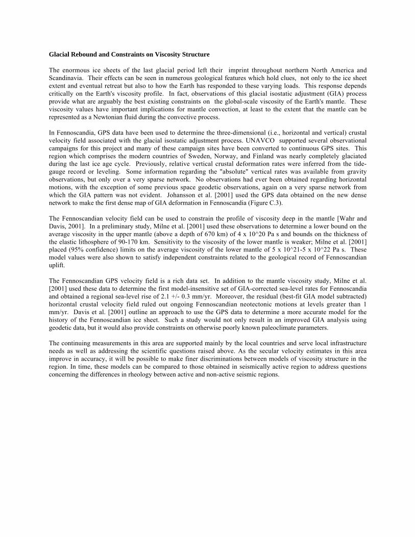
In Fennoscandia, GPS data have been used to determine the three-dimensional (i.e., horizontal and vertical) crustalvelocity field associated with the glacial isostatic adjustment process. UNAVCO supported several observationalcampaigns for this project and many of these campaign sites have been converted to continuous GPS sites. Thisregion which comprises the modern countries of Sweden, Norway, and Finland was nearly completely glaciatedduring the last ice age cycle. Previously, relative vertical crustal deformation rates were inferred from the tide-gauge record or leveling. Some information regarding the "absolute" vertical rates was available from gravityobservations, but only over a very sparse network. No observations had ever been obtained regarding horizontalmotions, with the exception of some previous space geodetic observations, again on a very sparse network fromwhich the GIA pattern was not evident. Johansson et al. [2001] used the GPS data obtained on the new densenetwork to make the first dense map of GIA deformation in Fennoscandia (Figure C.3).
The Fennoscandian velocity field can be used to constrain the profile of viscosity deep in the mantle [Wahr andDavis, 2001]. In a preliminary study, Milne et al. [2001] used these observations to determine a lower bound on theaverage viscosity in the upper mantle (above a depth of 670 km) of 4 x 10^20 Pa s and bounds on the thickness ofthe elastic lithosphere of 90-170 km. Sensitivity to the viscosity of the lower mantle is weaker; Milne et al. [2001]placed (95% confidence) limits on the average viscosity of the lower mantle of 5 x 10^21-5 x 10^22 Pa s. Thesemodel values were also shown to satisfy independent constraints related to the geological record of Fennoscandianuplift.
The Fennoscandian GPS velocity field is a rich data set. In addition to the mantle viscosity study, Milne et al.[2001] used these data to determine the first model-insensitive set of GIA-corrected sea-level rates for Fennoscandiaand obtained a regional sea-level rise of 2.1 +/- 0.3 mm/yr. Moreover, the residual (best-fit GIA model subtracted)horizontal crustal velocity field ruled out ongoing Fennoscandian neotectonic motions at levels greater than 1mm/yr. Davis et al. [2001] outline an approach to use the GPS data to determine a more accurate model for thehistory of the Fennoscandian ice sheet. Such a study would not only result in an improved GIA analysis usinggeodetic data, but it would also provide constraints on otherwise poorly known paleoclimate parameters.
The continuing measurements in this area are supported mainly by the local countries and serve local infrastructureneeds as well as addressing the scientific questions raised above. As the secular velocity estimates in this areaimprove in accuracy, it will be possible to make finer discriminations between models of viscosity structure in theregion. In time, these models can be compared to those obtained in seismically active region to address questionsconcerning the differences in rheology between active and non-active seismic regions.
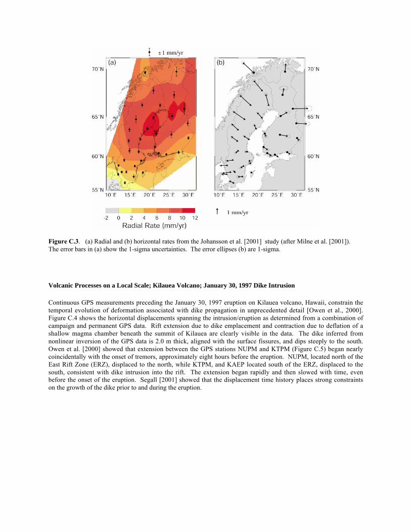
Figure C.3. (a) Radial and (b) horizontal rates from the Johansson et al. [2001] study (after Milne et al. [2001]).The error bars in (a) show the 1-sigma uncertainties. The error ellipses (b) are 1-sigma.
Volcanic Processes on a Local Scale; Kilauea Volcano; January 30, 1997 Dike Intrusion
Continuous GPS measurements preceding the January 30, 1997 eruption on Kilauea volcano, Hawaii, constrain thetemporal evolution of deformation associated with dike propagation in unprecedented detail [Owen et al., 2000].Figure C.4 shows the horizontal displacements spanning the intrusion/eruption as determined from a combination ofcampaign and permanent GPS data. Rift extension due to dike emplacement and contraction due to deflation of ashallow magma chamber beneath the summit of Kilauea are clearly visible in the data. The dike inferred fromnonlinear inversion of the GPS data is 2.0 m thick, aligned with the surface fissures, and dips steeply to the south.Owen et al. [2000] showed that extension between the GPS stations NUPM and KTPM (Figure C.5) began nearlycoincidentally with the onset of tremors, approximately eight hours before the eruption. NUPM, located north of theEast Rift Zone (ERZ), displaced to the north, while KTPM, and KAEP located south of the ERZ, displaced to thesouth, consistent with dike intrusion into the rift. The extension began rapidly and then slowed with time, evenbefore the onset of the eruption. Segall [2001] showed that the displacement time history places strong constraintson the growth of the dike prior to and during the eruption.
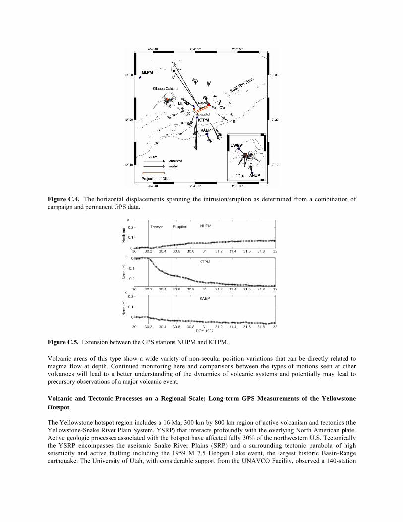
Figure C.4. The horizontal displacements spanning the intrusion/eruption as determined from a combination ofcampaign and permanent GPS data.
Figure C.5. Extension between the GPS stations NUPM and KTPM.
Volcanic areas of this type show a wide variety of non-secular position variations that can be directly related tomagma flow at depth. Continued monitoring here and comparisons between the types of motions seen at othervolcanoes will lead to a better understanding of the dynamics of volcanic systems and potentially may lead toprecursory observations of a major volcanic event.
Volcanic and Tectonic Processes on a Regional Scale; Long-term GPS Measurements of the YellowstoneHotspot
The Yellowstone hotspot region includes a 16 Ma, 300 km by 800 km region of active volcanism and tectonics (theYellowstone-Snake River Plain System, YSRP) that interacts profoundly with the overlying North American plate.Active geologic processes associated with the hotspot have affected fully 30% of the northwestern U.S. Tectonicallythe YSRP encompasses the aseismic Snake River Plains (SRP) and a surrounding tectonic parabola of highseismicity and active faulting including the 1959 M 7.5 Hebgen Lake event, the largest historic Basin-Rangeearthquake. The University of Utah, with considerable support from the UNAVCO Facility, observed a 140-station
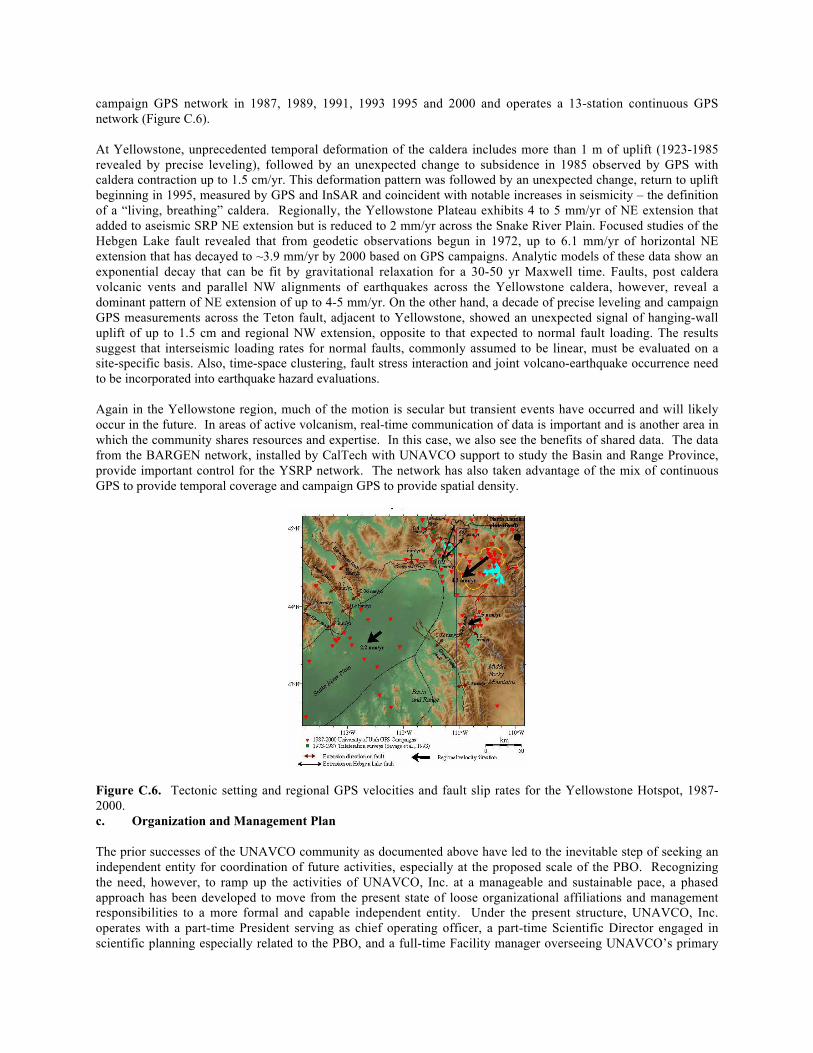
campaign GPS network in 1987, 1989, 1991, 1993 1995 and 2000 and operates a 13-station continuous GPSnetwork (Figure C.6).
At Yellowstone, unprecedented temporal deformation of the caldera includes more than 1 m of uplift (1923-1985revealed by precise leveling), followed by an unexpected change to subsidence in 1985 observed by GPS withcaldera contraction up to 1.5 cm/yr. This deformation pattern was followed by an unexpected change, return to upliftbeginning in 1995, measured by GPS and InSAR and coincident with notable increases in seismicity – the definitionof a “living, breathing” caldera. Regionally, the Yellowstone Plateau exhibits 4 to 5 mm/yr of NE extension thatadded to aseismic SRP NE extension but is reduced to 2 mm/yr across the Snake River Plain. Focused studies of theHebgen Lake fault revealed that from geodetic observations begun in 1972, up to 6.1 mm/yr of horizontal NEextension that has decayed to ~3.9 mm/yr by 2000 based on GPS campaigns. Analytic models of these data show anexponential decay that can be fit by gravitational relaxation for a 30-50 yr Maxwell time. Faults, post calderavolcanic vents and parallel NW alignments of earthquakes across the Yellowstone caldera, however, reveal adominant pattern of NE extension of up to 4-5 mm/yr. On the other hand, a decade of precise leveling and campaignGPS measurements across the Teton fault, adjacent to Yellowstone, showed an unexpected signal of hanging-walluplift of up to 1.5 cm and regional NW extension, opposite to that expected to normal fault loading. The resultssuggest that interseismic loading rates for normal faults, commonly assumed to be linear, must be evaluated on asite-specific basis. Also, time-space clustering, fault stress interaction and joint volcano-earthquake occurrence needto be incorporated into earthquake hazard evaluations.
Again in the Yellowstone region, much of the motion is secular but transient events have occurred and will likelyoccur in the future. In areas of active volcanism, real-time communication of data is important and is another area inwhich the community shares resources and expertise. In this case, we also see the benefits of shared data. The datafrom the BARGEN network, installed by CalTech with UNAVCO support to study the Basin and Range Province,provide important control for the YSRP network. The network has also taken advantage of the mix of continuousGPS to provide temporal coverage and campaign GPS to provide spatial density.
Figure C.6. Tectonic setting and regional GPS velocities and fault slip rates for the Yellowstone Hotspot, 1987-2000.c. Organization and Management Plan
The prior successes of the UNAVCO community as documented above have led to the inevitable step of seeking anindependent entity for coordination of future activities, especially at the proposed scale of the PBO. Recognizingthe need, however, to ramp up the activities of UNAVCO, Inc. at a manageable and sustainable pace, a phasedapproach has been developed to move from the present state of loose organizational affiliations and managementresponsibilities to a more formal and capable independent entity. Under the present structure, UNAVCO, Inc.operates with a part-time President serving as chief operating officer, a part-time Scientific Director engaged inscientific planning especially related to the PBO, and a full-time Facility manager overseeing UNAVCO’s primary
operational facility. The elected Board of Directors, currently chaired by Geoff Blewitt of the University of Nevada-Reno, selects the President and Scientific Director, makes corporate policy, and sets priorities for budgeting andresource use.
At present, UNAVCO, Inc. President James Davis of the Smithsonian Astrophysical Observatory (SAO) isuncompensated, Scientific Director Tom Herring of MIT is partially compensated via a subcontract from UCARwhich is the current UNAVCO grantee, and Facility Manager Wayne Shiver is a UCAR employee. Under thisstructure, the elected and appointed officials of UNAVCO, Inc. have no direct control of agency funds awarded onbehalf of the community they represent. The system works based on goodwill and the knowledge that thecommunity sets goals and priorities through election of the Board and the proposal peer review process. UNAVCOprincipals must be attuned to these community goals and priorities or risk loosing support and agency funding. TheGPS research community and sponsors, however, have stated the desire for more direct control of the organization,management and funding of UNAVCO, especially with the prospect of a large-scale GPS project such as PBO. Thisproposal is the first step in that direction.
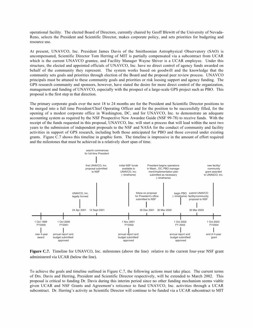
The primary corporate goals over the next 18 to 24 months are for the President and Scientific Director positions tobe merged into a full time President/Chief Operating Officer and for the position to be successfully filled, for theopening of a modest corporate office in Washington, DC, and for UNAVCO, Inc. to demonstrate an adequateaccounting system as required by the NSF Prospective New Awardee Guide (NSF 99-78) to receive funds. With thereceipt of the funds requested in this proposal, UNAVCO, Inc. will start a process that will lead within the next twoyears to the submission of independent proposals to the NSF and NASA for the conduct of community and facilityactivities in support of GPS research, including both those anticipated for PBO and those covered under existinggrants. Figure C.7 shows this timeline in graphic form. The timeline is impressive in the amount of effort requiredand the milestones that must be achieved in a relatively short span of time.
1 Oct 1999 1 Oct 2000 1 Nov 2001 1 Oct 2002 1 Oct 2003 FY2000 FY2001 FY2002 FY 2003 FY2004
new 4-year annual report and annual report and annual report and end of 4-year award budget submitted/ budget submitted/ budget submitted/ grant
approved approved approved
UNAVCO, Inc. legally formed
first UNAVCO, Inc.proposal submitted
to NSF
search commences for full-time President
follow-on proposal for President's office (~timeframe) submitted to NSF
President begins operationsin Wash., DC; PBO manage-
ment/implementation plansubmitted as necessary
(~timeframe)
begin PBO submit UNAVCOfacility/community proposal to NSF
24 Apr 2001 12 Sept 2001 30 Dec 2001 30 Mar 2002
30 Mar 2003
initial NSF fundsavailable to
UNAVCO, Inc.(~timeframe)
new facility/ community
grant awardedto UNAVCO, Inc.
Figure C.7. Timeline for UNAVCO, Inc. milestones (above the line) relative to the current four-year NSF grantadministered via UCAR (below the line).
To achieve the goals and timeline outlined in Figure C.7, the following actions must take place. The current termsof Drs. Davis and Herring, President and Scientific Director respectively, will be extended to March 2002. Thisproposal is critical to funding Dr. Davis during this interim period since no other funding mechanism seems viablegiven UCAR and NSF Grants and Agreement’s reticence to fund UNAVCO, Inc. activities through a UCARsubcontract. Dr. Herring’s activity as Scientific Director will continue to be funded via a UCAR subcontract to MIT
using existing funds. A search for the new full-time UNAVCO, Inc. President will commence immediately underthe direction of the Board of Directors.
Assuming the successful outcome of the President search process, a follow-on proposal to fund the salary andactivity of the new President and a small Washington, DC office will be submitted to the NSF in December 2001.The intent is to approach other university-based research consortia with offices in Washington, DC such as theIncorporated Research Institutions for Seismology (IRIS) about their willingness to sublease a small office. Thegoal is to have the President ensconced in his/her offices by March 2002 working on behalf of the UNAVCO, Inc.member institutions, the broader GPS research community, and the PBO initiative. The primary responsibilities inthe first year of this position will be building a strong member consortium representing U.S. universities and otherinstitutions using GPS technology, responding to proposal and other organizing and planning priorities for the PBO,and starting the development of the next UNAVCO facility/community proposal to the NSF which must besubmitted in April of 2003.
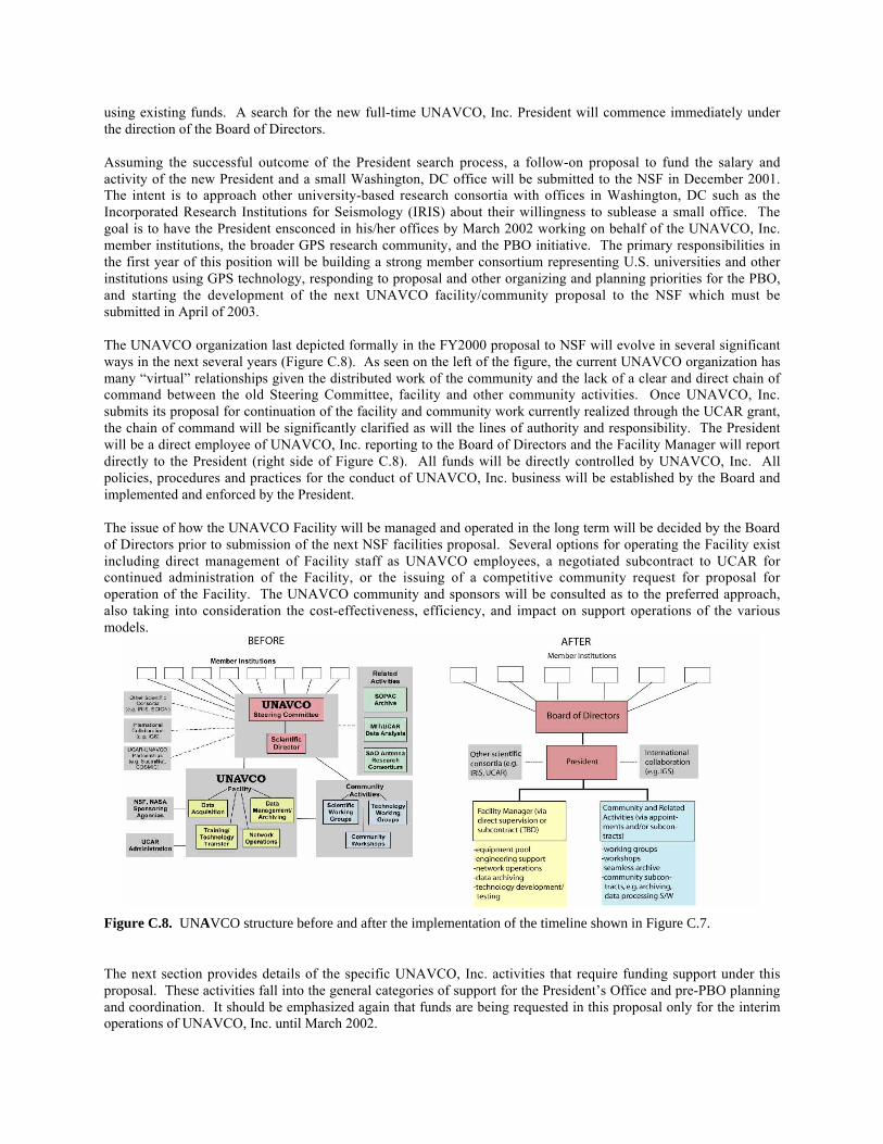
The UNAVCO organization last depicted formally in the FY2000 proposal to NSF will evolve in several significantways in the next several years (Figure C.8). As seen on the left of the figure, the current UNAVCO organization hasmany “virtual” relationships given the distributed work of the community and the lack of a clear and direct chain ofcommand between the old Steering Committee, facility and other community activities. Once UNAVCO, Inc.submits its proposal for continuation of the facility and community work currently realized through the UCAR grant,the chain of command will be significantly clarified as will the lines of authority and responsibility. The Presidentwill be a direct employee of UNAVCO, Inc. reporting to the Board of Directors and the Facility Manager will reportdirectly to the President (right side of Figure C.8). All funds will be directly controlled by UNAVCO, Inc. Allpolicies, procedures and practices for the conduct of UNAVCO, Inc. business will be established by the Board andimplemented and enforced by the President.
The issue of how the UNAVCO Facility will be managed and operated in the long term will be decided by the Boardof Directors prior to submission of the next NSF facilities proposal. Several options for operating the Facility existincluding direct management of Facility staff as UNAVCO employees, a negotiated subcontract to UCAR forcontinued administration of the Facility, or the issuing of a competitive community request for proposal foroperation of the Facility. The UNAVCO community and sponsors will be consulted as to the preferred approach,also taking into consideration the cost-effectiveness, efficiency, and impact on support operations of the variousmodels.
Figure C.8. UNAVCO structure before and after the implementation of the timeline shown in Figure C.7.
The next section provides details of the specific UNAVCO, Inc. activities that require funding support under thisproposal. These activities fall into the general categories of support for the President’s Office and pre-PBO planningand coordination. It should be emphasized again that funds are being requested in this proposal only for the interimoperations of UNAVCO, Inc. until March 2002.
2. Proposed Activities
UNAVCO, Inc. must have the ability to operate as a corporation during the interim period between now and theestablishment of a full time President and Washington, DC office if the milestones of Figure C.7 are to be achieved.The proposed mechanism is for Dr. Davis to establish and maintain the basic administrative, financial management,and contracts management capability through the use of shared resources at his home institution and purchasedservices of a contracts specialist. The mechanism for accomplishing this is discussed in the following section.
a. President’s Office
Considerable thought has been given as to how most efficiently and cost effectively to meet the needs of corporateUNAVCO on an interim basis. The possibility of a rented office in the Boston area in proximity to Drs. Davis andHerring along with temporary, part time administrative support was considered and determined to be impractical andinefficient. The logistics and time involved in Drs. Davis and Herring moving between offices as they performSAO, MIT and UNAVCO responsibilities was deemed grossly inefficient. Also, having paid administrative staffon-site, even when work might not be available, was not deemed cost effective.
The responsibilities of UNAVCO’s previous and present Scientific Directors have been successfully accomplishedwhile they remained in their home institutions. Dr. Herring, for example, is funded under a UCAR-MIT subcontractand his compensation, travel, administration, and computing support is accounted for within the subcontract. MITmade the institutional commitment to support Dr. Herring in his UNAVCO role. In the case of Dr. Davis,UNAVCO, Inc. has approached the Smithsonian Astrophysical Observatory (SAO) for a similar arrangementregarding his services as UNAVCO, Inc. President. This approach is deemed the most cost effective and efficientmeans of fulfilling the leadership and senior administrative needs of UNAVCO, Inc. while a full time President isbeing recruited. The requirement for financial management and contracts expertise will be purchased from a servicethat is well versed in meeting government requirements for receiving and managing funds and in subcontractingaccording to government regulation.
President’s Duties
The functions to be performed by Dr. Davis as UNAVCO, Inc. President will be similar to those of any ChiefExecutive Officer of a research nonprofit organization such as IRIS or UCAR. He will be responsible foroverseeing and participating in meetings of the Board of Directors, briefing the Directors on UNAVCO activities,and reviewing and approving UNAVCO, Inc. proposals, budgets and operating plans. The Board of Directors andan appointed UNAVCO Membership Committee will respond to member applications as the organization grows butDr. Davis will be the primary interface to ensure compliance with membership criteria established within thebylaws. He will be the primary day-to-day contact with member institutions and representatives in all mattersrelated to UNAVCO business. Finally, Dr. Davis will ensure UNAVCO, Inc. is operating in accordance with itsbylaws and all applicable laws of the State of Colorado.
Additional duties for Dr. Davis include being the primary interface with NSF in ensuring that the financialmanagement system previously established meets NSF Grants and Agreement’s requirements for receipt of funds.This will require the selection and managing of the service that will maintain the system and represent UNAVCO inany required reviews or audits. Preliminary negotiations will need to commence regarding establishment of aCooperative Agreement between the NSF and UNAVCO, Inc. for receipt of PBO and other facility/communityfunds. UNAVCO, Inc. will have to start considering issues of how its facility and community support issues mightbe addressed in the future including how to operate its facility.
The third primary area of responsibility for Dr. Davis will be taking the leadership role in responding to thecommunity mandate for UNAVCO, Inc. to manage PBO. Various plans for management, operational deployment,hardware/software configuration, technology development/evaluation, data management and archiving, andsubcontracting must be developed by the community under UNAVCO leadership prior to operational deployment ofPBO. These tasks will be undertaken based on plans developed by the community at a series of workshops that aredescribed in the next section of this proposal. To be successful, PBO needs a strong institutional tie, visionaryleadership, and solid management. UNAVCO, Inc. is being created by the community in part to meet these needs.
Dr. Davis will be the principal UNAVCO player in ensuring the early planning success of PBO and the future full-time President will be a leader in EarthScope and PBO implementation. Dr. Herring will continue to providescientific leadership as PBO develops and his and Dr. Davis’ responsibilities will be merged under the newPresident.
Finance/Contracts Manager’s Duties
UNAVCO, Inc. will secure through the use of private funds the services of an expert in government researchfunding, funds management, accounting, and contracts to develop the initial financial management and accountingsystem for UNAVCO, Inc. Funds are requested in this proposal for this same individual to be the primary point ofcontact for the establishment of a grant mechanism between NSF and UNAVCO, Inc. for the receipt of future funds.This individual will also in the future execute various subcontracts for other community activities including at somepoint the subcontracts for the Seamless Archive project currently in place with Scripps and MIT and the GPSVelproject conducted by the University of Nevada-Reno. This individual will also work with the UNAVCO, Inc.administrative staff to arrange the PBO workshops discussed below and to pay for services related to theseworkshops. Dr. Davis has identified a candidate for the Finance/Contracts Manager firm that is familiar with SAOand UNAVCO operations, and NSF funding regulations.
During this interim period of operations, UNAVCO, Inc. will propose to NSF a gradual transition of funds thatcurrently go through the NSF-UCAR Cooperative Agreement to start being passed directly to UNAVCO, Inc. Thecriteria will be that all facility funds will continue to pass through UCAR and all community activity funds will godirectly to UNAVCO, Inc. This will save costs in terms of UCAR overhead charged on these funds. The possibilityalso exists for other agency funds to be awarded to UNAVCO, Inc. so the plan is to transition to an indirect costsystem as soon as practicable, certainly before the next facility/community proposal is submitted to NSF in March2003.
b. Pre-Plate Boundary Observatory (PBO) Workshops
In preparation for Earthscope, the Earthscope Working Group in consultation with the community and the NSF hasdecided on a number of activities that will advance the rapid deployment of Earthscope instrumentation. UNAVCOInc. is taking the lead role in organizing those activities associated with the PBO component of Earthscope,including several workshops described below. These activities are summarized here and are described morecompletely in the document entitled “Moving EarthScope Forward” developed jointly by Southern CaliforniaEarthquake Center (SCEC), IRIS, and UNAVCO in concert with the EarthScope Working Group.
GPS Monumentation and Instrumentation Workshop (Co-conveners Tom Herring, Ken Hudnut, and ChuckMeertens)
The question of monument type and specific equipment requirements for PBO will involve considerable analysisbefore deployment. This workshop and the preparatory work in advance of it will provide a means of makinginformed decisions on four key technical issues amongst others:
• the best GPS monument type for a given geologic area and ground type.• type of receiver, telemetry and power systems needed based on available infrastructure at sites.• type of antenna to be used due to both cost considerations and the new proposed L5 civilian GPS
frequency.• desirable electromagnetic (EM) characteristics of sites.
The primary goal of the workshop is to identify and characterize the various sources of noise in GPS data sets fromwhich the above technical questions can be answered. One of the critical actions is to establish a consensusregarding the various sources of noise and errors by collecting results from existing analyses of data and thendetermining the noise budget. A key question to answer is: What parts of the error budget can be attributed tomonument noise, EM environment noise, local environment noise (e.g., ground water effects), equipment, or long-term systematic errors in the GPS system itself (the "common-mode" error)? Much of the background informationneeded for this effort can be obtained by examining studies done for the SCIGN array which attempted to address
many of the same questions, updated with the five-years of data since collected from the SCIGN array and frommany other regional arrays that have been installed globally in the last few years. The primary efforts will beaccumulation and analysis of results prior to the workshop, the workshop meeting where “lessons learned” will beassessed, a follow-up plan for collecting data to better answer lingering questions, and a set of technicalrecommendations to the PBO Steering Committee. The $20K requested here is for the workshop only.
Strainmeter Workshop (Co-conveners Paul Silver, Evelyn Roeloffs, and Duncan Agnew)
Strainmeters are one of the two primary instrument types for PBO and a workshop dedicated to the technical andscientific aspects of this component is critical for the deployment of the PBO. The workshop will be held in fall2001 and will be organized by Paul Silver, Evelyn Roeloffs, and Duncan Agnew, with assistance from Alan Lindeof the PBO Steering Committee. We anticipate a two-day meeting with approximately 40 attendees, including theentire strainmeter community, as well as members of the broader geodetic community who want to learn more aboutstrainmeters. The following issues will be addressed:
• status of current data sets and observed phenomena• site selection, drilling, and installation• data processing• data management• optimizing scientific return
The goals of the proposed $40K workshop are to develop data processing and archiving standards, standardizedanalysis techniques, methods of integrating GPS and strainmeter data, and approaches to meeting the necessarystrainmeter production capacity goals required for PBO.
GPS Backbone Coordination with other Countries (Co-conveners Jeff Freymueller, Wayne Thatcher, andYehuda Bock)
Incorporating an understanding of tectonic processes occurring in Mexico and Canada is critical to making anaccurate interpretation of the integrated North America-Pacific plate boundary behavior. To address this issue, twosmall workshops are proposed to coordinate PBO activities with these two countries. These meetings will bringtogether scientists, surveyors, and government representatives of the respective governments and PBO participantsto find common ground for establishing PBO-grade backbone stations in western Canada and Mexico. The Canadaworkshop will be held in the Seattle, Washington area and the Mexico workshop in San Diego, California. Theprogrammatic focus of both workshops will be to help accelerate measurement programs in Canada and Mexico.The science focus will be to show how understanding the tectonics and processes occurring in these regions willimpact our interpretation of results from PBO. The $25K budget request will go towards travel and meetingexpenses for both of the two-day, ten person workshops.
PBO Management Workshop (Co-conveners Brian Wernicke and Jim Davis)
UNAVCO, Inc. has been given a community mandate to manage the PBO project in the event it is funded as an NSFMajor Research Equipment (MRE) initiative. The first order of business is to assemble key members of the PBOcommunity of participants to discuss the organization of PBO management as an operational activity of UNAVCO,Inc. The PBO Steering Committee has been working diligently for almost two years to frame the key scientificquestions to be addressed by PBO and to determine the most appropriate allocation of equipment resources toachieve those goals. The community now needs to catch up with the scientific side of the house to make the keydeterminations about how the community will actually manage and implement the PBO.
Among the fundamental issues to be addressed are:
• How will a PBO Director be selected and to whom will he/she report within UNAVCO, Inc.?• What will be the decision making and budgetary authority of the PBO Director?• How will the community make implementation decisions about the PBO facility?
• How will prime contracts and subcontracts for the implementation of PBO be determined and managed?• What will be the relationship between the PBO Director/Program and other government and non-
government entities with a stake in PBO, e.g., the U.S. Geological Survey, SCEC, individual participatinguniversities, etc.?
Other organizational, management, and implementation issues will, of course, arise as the community comes to gripswith the details of how the PBO is to be implemented. The essential first step toward building a communityconsensus is to have an inclusive discussion among the interested PBO participants to ensure that we have framedthe correct issues and identify a process for developing approaches to satisfying a broad constituency. The first stepin this process is to convene a workshop with representatives from UNAVCO, Inc., the UNAVCO Facility, SCIGN,SCEC, and major participating universities. Brian Wernicke of CalTech has agreed to chair the workshop and alongwith Jim Davis, UNAVCO, Inc. President, will be the co-conveners. The proposed $14K workshop is anticipated totake two days and involve a total of ten participants. The time and location will be confirmed with a preliminary listof participants once funding is available.
c. PBO Simulation and Network Design
The Plate Boundary Observatory will deploy large arrays of strainmeters and GPS receivers to study plate boundarydeformation at frequencies ranging from Hz to DC. Important goals are to study transient strain events, silentearthquakes, post-earthquake processes, and time dependent deformation accompanying volcanic eruptions. Thescale and scope of the experiment is unprecedented and demands a careful and thorough design phase. Up to thispoint, we have determined the overall level of instrumentation, the approximate mix of instrumentation, and thescientific targets that have the highest scientific merit, with approximate allocations to each of these areas. In thisnext phase, we propose to carry out a formal network design study. This will allow us to optimize the placement ofinstruments to maximize the detection and characterization of strain phenomena. Evaluating network performancewill be a crucial part of the siting process, particularly when we are faced with siting limitations. We will be able todecide between alternative siting plans based on performance. We thus propose a design and simulation phase toensure that PBO is as close to optimal as possible for studying the targeted processes.
The important question that needs to be addressed for each candidate process is: How will our ability to detect andcharacterize a given process (e.g., transient fault slip) vary with station spacing and mix of instrumentation?Detection and characterization suggest different deployment strategies, and the tradeoffs need to be understoodbefore PBO is deployed. One approach that could be informative is to simulate displacement and strain signals froma variety of processes (e.g., silent earthquakes, transient post-seismic slip, dike propagation) for a given networkdesign (e.g., mix of instruments and station geometry). The synthetic signals would be inverted using a variety ofinversion schemes to determine how well the source processes can be retrieved. It will thus be necessary to developmetrics to measure network performance. The network geometry will then be modified and the process repeated.The preferred network designs will be those that optimize the design metrics for the given candidate process. Theinversion approach should allow for a variety of models and data types, and all signals from the deformationnetwork should be analyzed simultaneously. Of special importance is being able to distinguish local non-tectonicprocesses (e.g., benchmark wobble) from spatially coherent tectonic or volcanic processes.
In all, this task is expected to take a year of post-doctoral time, which is estimated to cost $80K. We propose toannounce a call for mini-proposals for those interested in accomplishing this task. This will take the same form asthe mini-proposals submitted to the 2nd PBO workshop, and we will form a panel to make the final award decision.Goals of the effort include developing error spectra and error models for different instrument types including GPS,borehole strain, and long baseline strain; developing design metrics for measuring network performance for bothdetection and characterization; developing synthetic source models (e.g., slow earthquakes, transient slip, dikepropagation); testing candidate networks with various sources; and, determining optimal network designs.
3. Scientific Benefits and Outcomes/Anticipated Results
This proposal juxtaposes two seemingly incongruous elements, scientific advancement and institution building. Thehistory of the UNAVCO community and the research examples presented in this proposal, however, show thathaving a centralized focus to develop new technology and capability can result in significant scientific achievement.This proposal requests the resources to take the past accomplishments and applications of GPS and relatedtechnologies achieved by the UNAVCO community to new levels. The GPS equipment, engineering support,technology developments, data processing tools, archived data, and community-building venues historicallyprovided by UNAVCO will continue. There will be a new focus, however, on greater efficiency and cost-effectiveness in operations, direct control of financial and other resources, greater collaboration at the communitylevel on hardware and software design, production of more standardized data collection systems, increased synergyin data archiving, provision to a broader community of a suite of data products, a gradual and measured ramping upof capability to the scale of PBO, and finally and perhaps most important a greater sense of collegiality andcommunity among the users and advocates of GPS and related technology.
To accomplish these admittedly ambitious goals, the UNAVCO community needs support to create capability,practices, and its own institutions based on how best to serve its research support needs. This first step of acceptingdirect responsibility for receipt and accountability of funds is critical. At a minimum, UNAVCO, Inc. is being askedin the next few years to mature to the point of accepting and responsibly managing over $3 million in inter-agencyfunds per year. If EarthScope and PBO succeed, UNAVCO, Inc. is being asked in the same time frame to developcapability to the point of accepting and responsibly managing five times that amount of funds. The goal, of course,is not to manage money but to advance our scientific understanding of the Earth, especially the most complex anddynamic components of the Earth such as the western U. S. plate boundary. This proposal contributes to both thedetailed early planning needed for the successful implementation of PBO and to creation of those longer-terminstitutions essential to the future disciplines of precise geodesy and strain measurement and all the promise theyhold for advancing Earth sciences.
D. References
Davis, J. L., J. L. Fastook, G. A. Milne, H.-G. Scherneck, J. M. Johansson, J.-O. Naslund, andL. L. Dimitrova, A new method for improving glaciation history and paleoclimateparameters using space geodetic data, to be submitted to Glacial Isostatic Adjustment andthe Earth System, edited by J. X. Mitrovica and L. L. A. Vermeersen, AmericanGeophysical Union, 2001.
Hearn, E., R. Burgmann, and R. Reilinger, Dynamics of Izmit Earthquake PostseismicDeformation and Loading of the Duzce Earthquake Hypocenter, Bull. Seis. Soc. Am., inpress, 2001.
Herring, T. A., Geodetic Applications of GPS, Proceedings of the IEEE, 87, 1, 92—110, 1999.
Johansson, J. M., J. L. Davis, H.-G. Scherneck, G. A. Milne, M. Vermeer, J. X. Mitrovica, R.A. Bennett, B. Jonsson, G. Elgered, P. Elosegui, H. Koivula, M. Poutanen, B. O.Ronnang, and I. I. Shapiro, Continuous GPS measurements of postglacial adjustment inFennoscandia, 1. Geodetic results, submitted to J. Geophys. Res., 2001.
Milne, G. A., J. L. Davis, J. X. Mitrovica, H.-G. Scherneck, J. M. Johansson, and M. Vermeer,Space-geodetic constraints on glacial isostatic adjustment in Fennoscandia, Science, 291,2381-2385, 2001.
Owen, S., P. Segall, M. Lisowski, M. Murray, M. Bevis, and J. Foster, The January 30, 1997eruptive event on Kilauea Volcano, Hawaii, as monitored by continuous GPS, Geophys.Res. Lett., 27, 2,757-2,760, 2000.
Parsons, T., S. Toda, R. S. Stein, A. Barka and J. H. Dieterich, Heightened odds of largeearthquakes near Istanbul: An interaction-based probability calculation, Science, 288, pp.661-665, 2000
Reilinger, R., S. Ergintav, R. Burgmann, S. McCluskey, O. Lenk, A. Barka, O. Gurkan, E.Hearn, K. Fleigl, R. Calmak, B. Aktung, H. Ozener, and M. Tokoz, Coseismic andpostseismic fault slip for the August 17 1999, M=7.5, Izmit, Turkey, Earthquake, Science,289, 1519–1524, 2000.
Segall, P., P. Cervelli, S. Owen, M. Lisowski, and A. Miklius, Constraints on dike propagationfrom continuous GPS measurements, J. Geophys. Res., in press, 2001.
Segall, P., and J. Davis, "GPS Applications for geodynamics and earthquake studies", Ann.Rev. Earth Planet. Sci., vol. 25, pp. 301-336, 1997.
Wahr, J., and J. L. Davis, Geodetic constraints on Glacial Isostatic Rebound, submitted toGlacial Isostatic Adjustment and the Earth System, edited by J. X. Mitrovica and L. L. A.Vermeersen, American Geophysical Union, 2001.
E. Biographical Sketches
Thomas A. HerringDepartment of Earth, Atmospheric and Planetary Sciences
Massachusetts Institute of Technology 54-618Cambridge, MA 02139
Tel.: 617-253-5941; Fax.: 617-253-1699E-mail: [email protected]
a. Professional Preparation:University of Queensland Surveying B. 1976University of Queensland Geodesy M. 1976Massachusetts Institute of Technology Geophysics Ph.D. 1983
b. Appointments:1997-Present Professor of Geophysics, MIT1992-1997 Associate Professor of Geophysics; Dept. of Earth, Atmospheric & Planetary Sciences, MIT1989-1992 Kerr-McGee Associate Professor of Geophysics, Dept. of Earth, Atmospheric, & Planetary
Sciences, MIT1983-1989 Research Associate, Harvard University
c. Publications:
Geodesy by radio interferometry: The application of Kalman filtering to the analysis of VLBI data, T.A. Herring,J.L. Davis, and I.I. Shapiro, J. Geophys. Res., 95, 12561-12581, 1990.
Effects of atmospheric azimuthal asymmetry of the analysis of space geodetic data, G. Chen, G. and T.A. Herring, J.Geophys. Res., 102, 20,489-20,502, 1977.
Southern California permanent GPS geodetic array: Continuous measurements of regional crustal deformation, Y.Bock, S. Wdowinskii, P. Fang, J. Behr, J. Genrich, S. Williams, D. Agnew, F. Wyatt, H. Johnson, S. Marquez,B. Oral, K. Hudnut, R. King, T. Herring, K. Stark, S. Dinardo, W. Young, D. Jackson, and W. Gurtner, J.Geophys. Res., 102, 18,013-18,033, 1977.
Estimating Regional Deformation from a Combination of Space and Terrestrial Geodetic Data, D. Dong, T.A.Herring, and R.W. King, J. Geodesy, 72, 200-214, 1998.
Geodetic constraints on the rigidity and relative motion of Eurasia and North America, M.G. Kogan, G.M. Steblov,R.W. King, T.A. Herring, D.I. Frolov, S.G. Egorov, V.Y. Levin, A. Lerner-Lam, and A. Jones, Geophys. Res.Lett., 27, 2041-2045, 2000.
Other Significant Publications
Diurnal and semidiurnal rotational variations and tidal parameters of the Earth, T.A. Herring and D. Dong, J.Geophys. Res., 99, 18,051-18,072, 1994.
Surface deformation caused by pressure changes in the fluid core, M. Fang, M., B. H. Hager, and T.A. Herring,Geophys. Res. Lett. 23, 1493-1496, 1996.
The Global Positioning System, T.A. Herring, Scientific America, Feb., 44-50, 1996.
Geodetic Applications of GPS, T.A. Herring, Proceedings of the IEEE, 87, 1, 92-110, 1999.
d. Synergistic Activities:
• Development of the GLOBK portion of GAMIT/GLOBK• Associate Analysis Center for the International GPS Service (http://www.gpsg.mit.edu/~fresh/MIT IGS
AAC.html)• Associate Editor, Journal of Geophysical Research: Editorial Board Journal of Geodynamics, Journal of
Geodesy.• Chair of International Association of Geodesy, Coordination of Space Techniques for Geodesy
(IAG/CSTG) project and subcommission for combination of results from Space Geodetic measurements.• Scientific Director, UNAVCO, 2000-2001.
e. Collaborators:
(i) Collaborators of Last Four YearsDuncan Agnew, UCSD; Michael Bevis, University of Hawaii; Yehuda Bock, UCSD; Bernard Minster, UCSD; BradHager, MIT; David Jackson, UCLA; Robert King, MIT ; Simon McClusky, MIT; Meghan Miller, CentralWashington University; Peter Molnar, MIT; Robert Reilonger, MIT; Zheng-kang Shen, UCLA;Seiichi Shimda, NIED, Japan;
(ii) Graduate and Post Doctoral Advisors
Irwin I. Shapiro (currently at Harvard University and Smithsonian Astrophysical Observatory).
(iii) Thesis Advisor and Postgraduate Scholars of Last Five Years
Gang Chen, An Nguyen, Monchaya Piboon, Katy Quinn (MIT Graduate Students)
Simon McClusky, Dang Yamin (Postdoctoral Fellows)
Wayne S. ShiverUNAVCO Facility Manager
3340 Mitchell LaneBoulder, Colorado 80301
Tel.: 303-497-8042; Fax.: 303-497-8028E-mail: [email protected]
URL: http://www.unavco.ucar.edu
a. Professional Preparation:University of North Carolina Geology B.S. 1972Naval Postgraduate School Oceanography & Meteorology M.S. 1977
b. Appointments:1994-Present UNAVCO Facility Manager1990-1994 Assistant to the President, University Corporation for Atmospheric Research1988-1990 Senior Program Manager, Science Applications International Corporation1985-1988 Executive Officer, Naval Environmental Prediction Research Facility1981-1985 Program Manager, Sippican Ocean Systems, Inc.1972-1981 US Naval Officer
c. Publications:None
d. Synergistic Activities:None
e. Collaborators:Tom Herring, MIT, UNAVCO Scientific DirectorJeffrey Freymueller, University of Alaska-Fairbanks, UNAVCO Steering Committee ChairSeth Stein, Northwestern University, UNAVCO Scientific Director
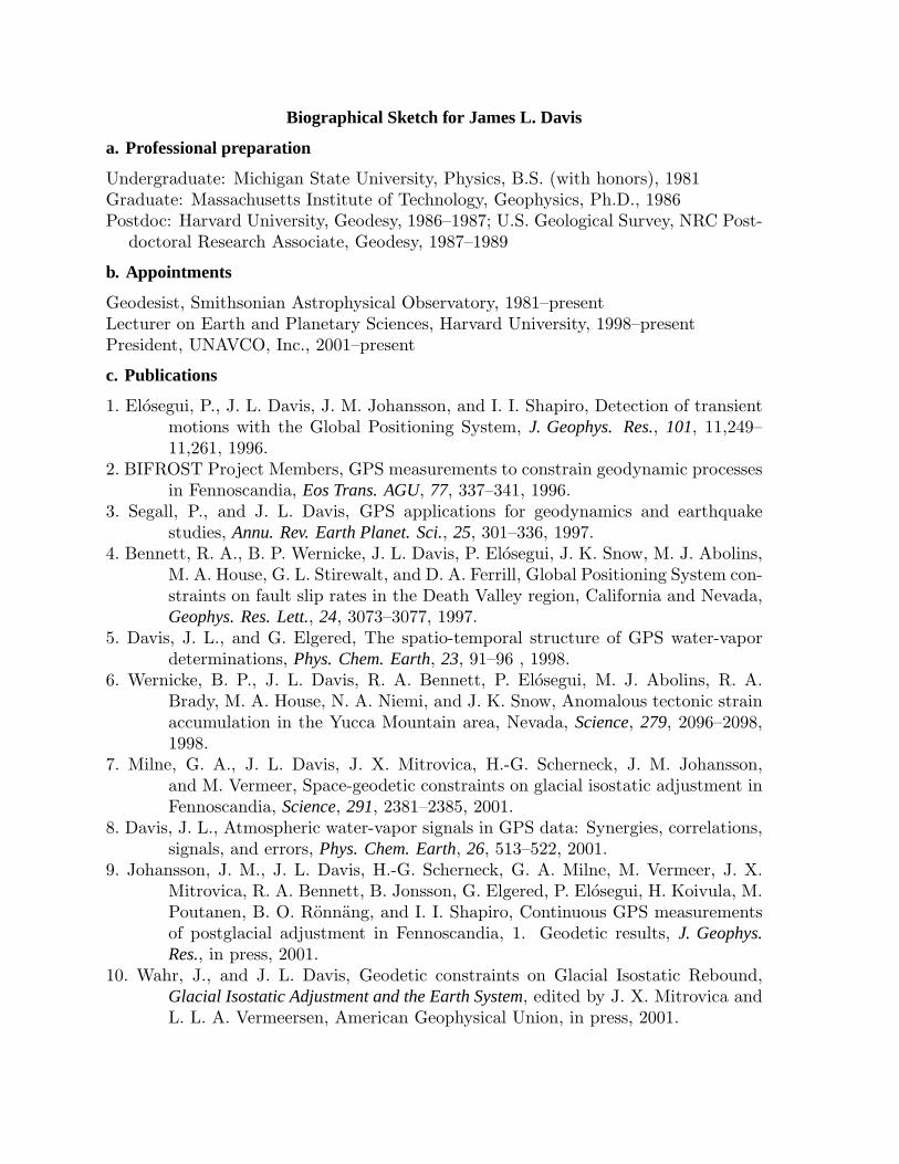
Biographical Sketch for James L. Davis
a. Professional preparation
Undergraduate: Michigan State University, Physics, B.S. (with honors), 1981Graduate: Massachusetts Institute of Technology, Geophysics, Ph.D., 1986Postdoc: Harvard University, Geodesy, 1986–1987; U.S. Geological Survey, NRC Post-
doctoral Research Associate, Geodesy, 1987–1989
b. Appointments
Geodesist, Smithsonian Astrophysical Observatory, 1981–presentLecturer on Earth and Planetary Sciences, Harvard University, 1998–presentPresident, UNAVCO, Inc., 2001–present
c. Publications
1. Elosegui, P., J. L. Davis, J. M. Johansson, and I. I. Shapiro, Detection of transientmotions with the Global Positioning System, J. Geophys. Res., 101, 11,249–11,261, 1996.
2. BIFROST Project Members, GPS measurements to constrain geodynamic processesin Fennoscandia, Eos Trans. AGU, 77, 337–341, 1996.
3. Segall, P., and J. L. Davis, GPS applications for geodynamics and earthquakestudies, Annu. Rev. Earth Planet. Sci., 25, 301–336, 1997.
4. Bennett, R. A., B. P. Wernicke, J. L. Davis, P. Elosegui, J. K. Snow, M. J. Abolins,M. A. House, G. L. Stirewalt, and D. A. Ferrill, Global Positioning System con-straints on fault slip rates in the Death Valley region, California and Nevada,Geophys. Res. Lett., 24, 3073–3077, 1997.
5. Davis, J. L., and G. Elgered, The spatio-temporal structure of GPS water-vapordeterminations, Phys. Chem. Earth, 23, 91–96 , 1998.
6. Wernicke, B. P., J. L. Davis, R. A. Bennett, P. Elosegui, M. J. Abolins, R. A.Brady, M. A. House, N. A. Niemi, and J. K. Snow, Anomalous tectonic strainaccumulation in the Yucca Mountain area, Nevada, Science, 279, 2096–2098,1998.
7. Milne, G. A., J. L. Davis, J. X. Mitrovica, H.-G. Scherneck, J. M. Johansson,and M. Vermeer, Space-geodetic constraints on glacial isostatic adjustment inFennoscandia, Science, 291, 2381–2385, 2001.
8. Davis, J. L., Atmospheric water-vapor signals in GPS data: Synergies, correlations,signals, and errors, Phys. Chem. Earth, 26, 513–522, 2001.
9. Johansson, J. M., J. L. Davis, H.-G. Scherneck, G. A. Milne, M. Vermeer, J. X.Mitrovica, R. A. Bennett, B. Jonsson, G. Elgered, P. Elosegui, H. Koivula, M.Poutanen, B. O. Ronnang, and I. I. Shapiro, Continuous GPS measurementsof postglacial adjustment in Fennoscandia, 1. Geodetic results, J. Geophys.Res., in press, 2001.
10. Wahr, J., and J. L. Davis, Geodetic constraints on Glacial Isostatic Rebound,Glacial Isostatic Adjustment and the Earth System, edited by J. X. Mitrovica andL. L. A. Vermeersen, American Geophysical Union, in press, 2001.
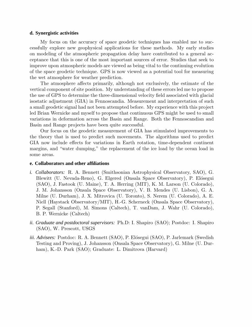
d. Synergistic activities
My focus on the accuracy of space geodetic techniques has enabled me to suc-cessfully explore new geophysical applications for these methods. My early studieson modeling of the atmospheric propagation delay have contributed to a general ac-ceptance that this is one of the most important sources of error. Studies that seek toimprove upon atmospheric models are viewed as being vital to the continuing evolutionof the space geodetic technique. GPS is now viewed as a potential tool for measuringthe wet atmosphere for weather prediction.
The atmosphere affects primarily, although not exclusively, the estimate of thevertical component of site position. My understanding of these errors led me to proposethe use of GPS to determine the three-dimensional velocity field associated with glacialisostatic adjustment (GIA) in Fennoscandia. Measurement and interpretation of sucha small geodetic signal had not been attempted before. My experience with this projectled Brian Wernicke and myself to propose that continuous GPS might be used to smallvariations in deformation across the Basin and Range. Both the Fennoscandian andBasin and Range projects have been quite successful.
Our focus on the geodetic measurement of GIA has stimulated improvements tothe theory that is used to predict such movements. The algorithms used to predictGIA now include effects for variations in Earth rotation, time-dependent continentmargins, and “water dumping,” the replacement of the ice load by the ocean load insome areas.
e. Collaborators and other affiliations
i. Collaborators: R. A. Bennett (Smithsonian Astrophysical Observatory, SAO), G.Blewitt (U. Nevada-Reno), G. Elgered (Onsala Space Observatory), P. Elosegui(SAO), J. Fastook (U. Maine), T. A. Herring (MIT), K. M. Larson (U. Colorado),J. M. Johansson (Onsala Space Observatory), V. B. Mendes (U. Lisbon), G. A.Milne (U. Durham), J. X. Mitrovica (U. Toronto), S. Nerem (U. Colorado), A. E.Niell (Haystack Observatory/MIT), H.-G. Scherneck (Onsala Space Observatory),P. Segall (Stanford), M. Simons (Caltech), T. vanDam, J. Wahr (U. Colorado),B. P. Wernicke (Caltech)
ii. Graduate and postdoctoral supervisors: Ph.D: I. Shapiro (SAO); Postdoc: I. Shapiro(SAO), W. Prescott, USGS
iii. Advisees: Postdoc: R. A. Bennett (SAO), P. Elosegui (SAO), P. Jarlemark (SwedishTesting and Proving), J. Johansson (Onsala Space Observatory), G. Milne (U. Dur-ham), K.-D. Park (SAO); Graduate: L. Dimitrova (Harvard)

SUMMARYPROPOSAL BUDGET
FundsRequested By
proposer
Fundsgranted by NSF
(if different)
Date Checked Date Of Rate Sheet Initials - ORG
NSF FundedPerson-mos.
FOR NSF USE ONLYORGANIZATION PROPOSAL NO. DURATION (months)
Proposed Granted
PRINCIPAL INVESTIGATOR / PROJECT DIRECTOR AWARD NO.
A. SENIOR PERSONNEL: PI/PD, Co-PI’s, Faculty and Other Senior Associates (List each separately with title, A.7. show number in brackets) CAL ACAD SUMR
$ $1.
2.
3.
4.
5.
6. ( ) OTHERS (LIST INDIVIDUALLY ON BUDGET JUSTIFICATION PAGE)
7. ( ) TOTAL SENIOR PERSONNEL (1 - 6)
B. OTHER PERSONNEL (SHOW NUMBERS IN BRACKETS)
1. ( ) POST DOCTORAL ASSOCIATES
2. ( ) OTHER PROFESSIONALS (TECHNICIAN, PROGRAMMER, ETC.)
3. ( ) GRADUATE STUDENTS
4. ( ) UNDERGRADUATE STUDENTS
5. ( ) SECRETARIAL - CLERICAL (IF CHARGED DIRECTLY)
6. ( ) OTHER
TOTAL SALARIES AND WAGES (A + B)
C. FRINGE BENEFITS (IF CHARGED AS DIRECT COSTS)
TOTAL SALARIES, WAGES AND FRINGE BENEFITS (A + B + C)
D. EQUIPMENT (LIST ITEM AND DOLLAR AMOUNT FOR EACH ITEM EXCEEDING $5,000.)
TOTAL EQUIPMENT
E. TRAVEL 1. DOMESTIC (INCL. CANADA, MEXICO AND U.S. POSSESSIONS)
2. FOREIGN
F. PARTICIPANT SUPPORT COSTS
1. STIPENDS $
2. TRAVEL
3. SUBSISTENCE
4. OTHER
TOTAL NUMBER OF PARTICIPANTS ( ) TOTAL PARTICIPANT COSTS
G. OTHER DIRECT COSTS
1. MATERIALS AND SUPPLIES
2. PUBLICATION COSTS/DOCUMENTATION/DISSEMINATION
3. CONSULTANT SERVICES
4. COMPUTER SERVICES
5. SUBAWARDS
6. OTHER
TOTAL OTHER DIRECT COSTS
H. TOTAL DIRECT COSTS (A THROUGH G)
I. INDIRECT COSTS (F&A)(SPECIFY RATE AND BASE)
TOTAL INDIRECT COSTS (F&A)
J. TOTAL DIRECT AND INDIRECT COSTS (H + I)
K. RESIDUAL FUNDS (IF FOR FURTHER SUPPORT OF CURRENT PROJECTS SEE GPG II.D.7.j.)
L. AMOUNT OF THIS REQUEST (J) OR (J MINUS K) $ $
M. COST SHARING PROPOSED LEVEL $ AGREED LEVEL IF DIFFERENT $
PI / PD TYPED NAME & SIGNATURE* DATE FOR NSF USE ONLYINDIRECT COST RATE VERIFICATION
ORG. REP. TYPED NAME & SIGNATURE* DATE
NSF Form 1030 (10/99) Supersedes all previous editions *SIGNATURES REQUIRED ONLY FOR REVISED BUDGET (GPG III.B)
1YEAR
1
UNAVCO, Inc.
Thomas
Thomas
Thomas
A
A
A
Herring
Herring
Herring - none 0.00 0.00 0.00 0Wayne Shiver - none 0.00 0.00 0.00 0
0 0.00 0.00 0.00 02 0.00 0.00 0.00 0
0 0.00 0.00 0.00 00 0.00 0.00 0.00 00 00 00 00 0
00
0
000
057,71519,900
069 77,615
775000
176,89227,810
205,477 283,092
0 (Rate: , Base: )
283,0920
283,0920
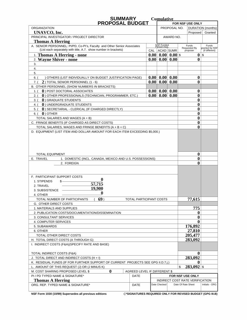
SUMMARYPROPOSAL BUDGET
FundsRequested By
proposer
Fundsgranted by NSF
(if different)
Date Checked Date Of Rate Sheet Initials - ORG
NSF FundedPerson-mos.
FOR NSF USE ONLYORGANIZATION PROPOSAL NO. DURATION (months)
Proposed Granted
PRINCIPAL INVESTIGATOR / PROJECT DIRECTOR AWARD NO.
A. SENIOR PERSONNEL: PI/PD, Co-PI’s, Faculty and Other Senior Associates (List each separately with title, A.7. show number in brackets) CAL ACAD SUMR
$ $1.
2.
3.
4.
5.
6. ( ) OTHERS (LIST INDIVIDUALLY ON BUDGET JUSTIFICATION PAGE)
7. ( ) TOTAL SENIOR PERSONNEL (1 - 6)
B. OTHER PERSONNEL (SHOW NUMBERS IN BRACKETS)
1. ( ) POST DOCTORAL ASSOCIATES
2. ( ) OTHER PROFESSIONALS (TECHNICIAN, PROGRAMMER, ETC.)
3. ( ) GRADUATE STUDENTS
4. ( ) UNDERGRADUATE STUDENTS
5. ( ) SECRETARIAL - CLERICAL (IF CHARGED DIRECTLY)
6. ( ) OTHER
TOTAL SALARIES AND WAGES (A + B)
C. FRINGE BENEFITS (IF CHARGED AS DIRECT COSTS)
TOTAL SALARIES, WAGES AND FRINGE BENEFITS (A + B + C)
D. EQUIPMENT (LIST ITEM AND DOLLAR AMOUNT FOR EACH ITEM EXCEEDING $5,000.)
TOTAL EQUIPMENT
E. TRAVEL 1. DOMESTIC (INCL. CANADA, MEXICO AND U.S. POSSESSIONS)
2. FOREIGN
F. PARTICIPANT SUPPORT COSTS
1. STIPENDS $
2. TRAVEL
3. SUBSISTENCE
4. OTHER
TOTAL NUMBER OF PARTICIPANTS ( ) TOTAL PARTICIPANT COSTS
G. OTHER DIRECT COSTS
1. MATERIALS AND SUPPLIES
2. PUBLICATION COSTS/DOCUMENTATION/DISSEMINATION
3. CONSULTANT SERVICES
4. COMPUTER SERVICES
5. SUBAWARDS
6. OTHER
TOTAL OTHER DIRECT COSTS
H. TOTAL DIRECT COSTS (A THROUGH G)
I. INDIRECT COSTS (F&A)(SPECIFY RATE AND BASE)
TOTAL INDIRECT COSTS (F&A)
J. TOTAL DIRECT AND INDIRECT COSTS (H + I)
K. RESIDUAL FUNDS (IF FOR FURTHER SUPPORT OF CURRENT PROJECTS SEE GPG II.D.7.j.)
L. AMOUNT OF THIS REQUEST (J) OR (J MINUS K) $ $
M. COST SHARING PROPOSED LEVEL $ AGREED LEVEL IF DIFFERENT $
PI / PD TYPED NAME & SIGNATURE* DATE FOR NSF USE ONLYINDIRECT COST RATE VERIFICATION
ORG. REP. TYPED NAME & SIGNATURE* DATE
NSF Form 1030 (10/99) Supersedes all previous editions *SIGNATURES REQUIRED ONLY FOR REVISED BUDGET (GPG III.B)
Cumulative
C
UNAVCO, Inc.
Thomas
Thomas
Thomas
A
A
A
Herring
Herring
Herring - none 0.00 0.00 0.00 0Wayne Shiver - none 0.00 0.00 0.00 0
0.00 0.00 0.00 02 0.00 0.00 0.00 0
0 0.00 0.00 0.00 00 0.00 0.00 0.00 00 00 00 00 0
00
0
000
057,71519,900
069 77,615
775000
176,89227,810
205,477 283,092
0
283,0920
283,0920
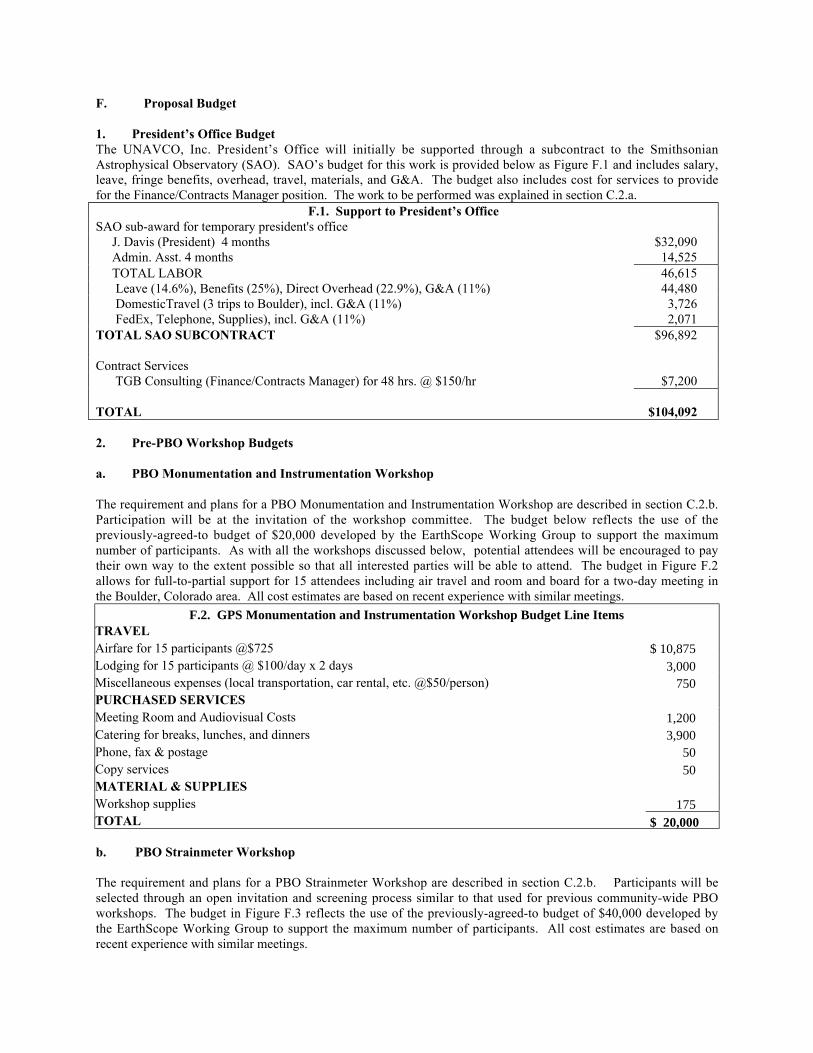
F. Proposal Budget
1. President’s Office BudgetThe UNAVCO, Inc. President’s Office will initially be supported through a subcontract to the SmithsonianAstrophysical Observatory (SAO). SAO’s budget for this work is provided below as Figure F.1 and includes salary,leave, fringe benefits, overhead, travel, materials, and G&A. The budget also includes cost for services to providefor the Finance/Contracts Manager position. The work to be performed was explained in section C.2.a.
F.1. Support to President’s OfficeSAO sub-award for temporary president's office J. Davis (President) 4 months $32,090 Admin. Asst. 4 months 14,525 TOTAL LABOR 46,615 Leave (14.6%), Benefits (25%), Direct Overhead (22.9%), G&A (11%) 44,480 DomesticTravel (3 trips to Boulder), incl. G&A (11%) 3,726 FedEx, Telephone, Supplies), incl. G&A (11%) 2,071TOTAL SAO SUBCONTRACT $96,892
Contract Services TGB Consulting (Finance/Contracts Manager) for 48 hrs. @ $150/hr $7,200
TOTAL $104,092
2. Pre-PBO Workshop Budgets
a. PBO Monumentation and Instrumentation Workshop
The requirement and plans for a PBO Monumentation and Instrumentation Workshop are described in section C.2.b.Participation will be at the invitation of the workshop committee. The budget below reflects the use of thepreviously-agreed-to budget of $20,000 developed by the EarthScope Working Group to support the maximumnumber of participants. As with all the workshops discussed below, potential attendees will be encouraged to paytheir own way to the extent possible so that all interested parties will be able to attend. The budget in Figure F.2allows for full-to-partial support for 15 attendees including air travel and room and board for a two-day meeting inthe Boulder, Colorado area. All cost estimates are based on recent experience with similar meetings.
F.2. GPS Monumentation and Instrumentation Workshop Budget Line ItemsTRAVEL Airfare for 15 participants @$725 $ 10,875Lodging for 15 participants @ $100/day x 2 days 3,000Miscellaneous expenses (local transportation, car rental, etc. @$50/person) 750PURCHASED SERVICES Meeting Room and Audiovisual Costs 1,200Catering for breaks, lunches, and dinners 3,900Phone, fax & postage 50Copy services 50MATERIAL & SUPPLIES Workshop supplies 175TOTAL $ 20,000
b. PBO Strainmeter Workshop
The requirement and plans for a PBO Strainmeter Workshop are described in section C.2.b. Participants will beselected through an open invitation and screening process similar to that used for previous community-wide PBOworkshops. The budget in Figure F.3 reflects the use of the previously-agreed-to budget of $40,000 developed bythe EarthScope Working Group to support the maximum number of participants. All cost estimates are based onrecent experience with similar meetings.
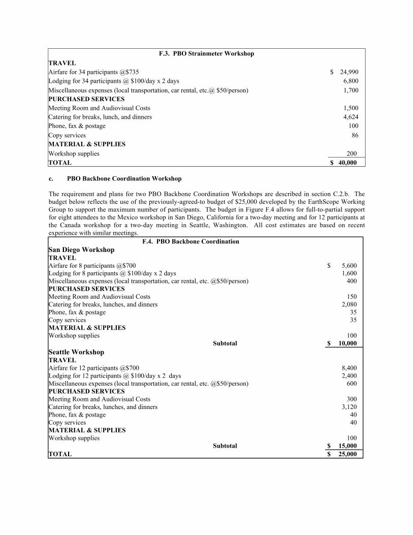
F.3. PBO Strainmeter Workshop
TRAVEL Airfare for 34 participants @$735 $ 24,990Lodging for 34 participants @ $100/day x 2 days 6,800
Miscellaneous expenses (local transportation, car rental, etc.@ $50/person) 1,700PURCHASED SERVICES Meeting Room and Audiovisual Costs 1,500Catering for breaks, lunch, and dinners 4,624Phone, fax & postage 100
Copy services 86MATERIAL & SUPPLIES Workshop supplies 200TOTAL $ 40,000
c. PBO Backbone Coordination Workshop
The requirement and plans for two PBO Backbone Coordination Workshops are described in section C.2.b. Thebudget below reflects the use of the previously-agreed-to budget of $25,000 developed by the EarthScope WorkingGroup to support the maximum number of participants. The budget in Figure F.4 allows for full-to-partial supportfor eight attendees to the Mexico workshop in San Diego, California for a two-day meeting and for 12 participants atthe Canada workshop for a two-day meeting in Seattle, Washington. All cost estimates are based on recentexperience with similar meetings.
F.4. PBO Backbone Coordination San Diego Workshop TRAVEL Airfare for 8 participants @$700 $ 5,600Lodging for 8 participants @ $100/day x 2 days 1,600Miscellaneous expenses (local transportation, car rental, etc. @$50/person) 400PURCHASED SERVICES Meeting Room and Audiovisual Costs 150Catering for breaks, lunches, and dinners 2,080Phone, fax & postage 35Copy services 35MATERIAL & SUPPLIES Workshop supplies 100 Subtotal $ 10,000Seattle Workshop TRAVEL Airfare for 12 participants @$700 8,400Lodging for 12 participants @ $100/day x 2 days 2,400Miscellaneous expenses (local transportation, car rental, etc. @$50/person) 600PURCHASED SERVICES Meeting Room and Audiovisual Costs 300Catering for breaks, lunches, and dinners 3,120Phone, fax & postage 40Copy services 40MATERIAL & SUPPLIES Workshop supplies 100 Subtotal $ 15,000TOTAL $ 25,000
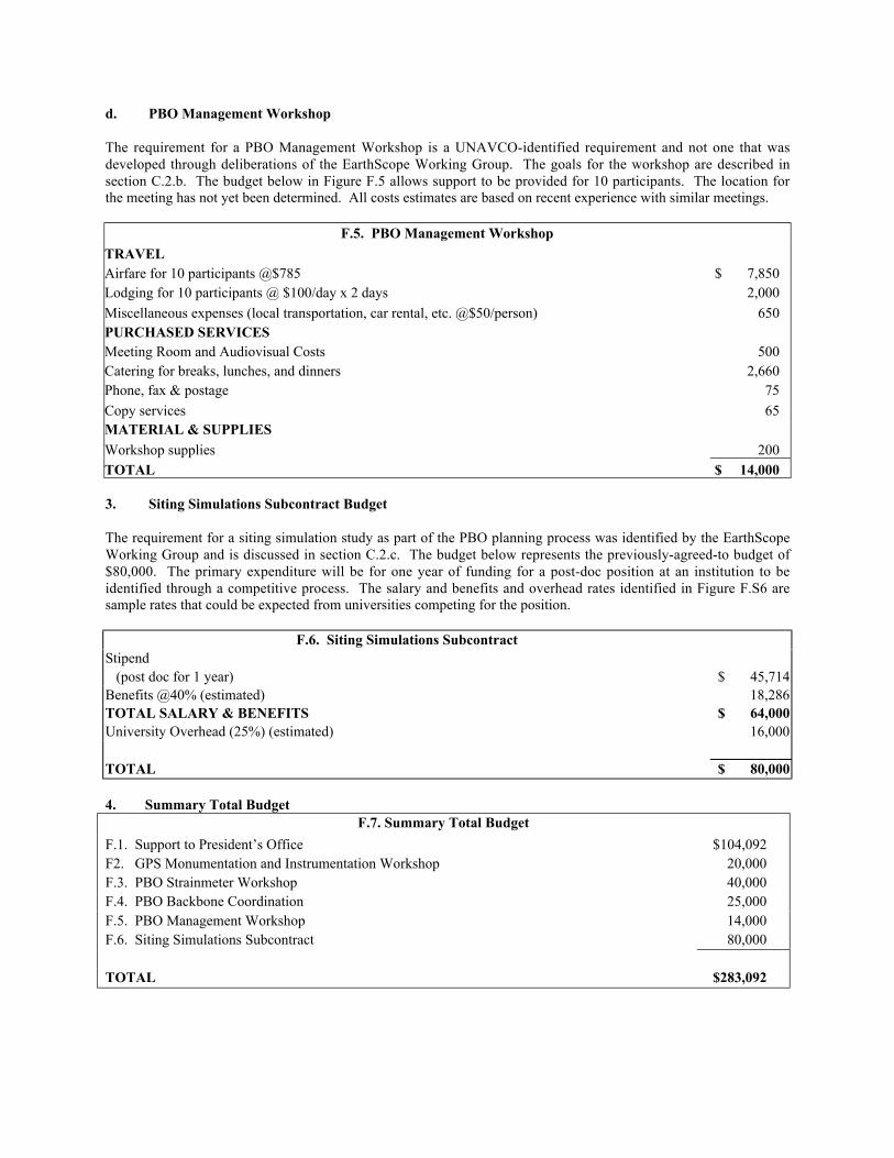
d. PBO Management Workshop
The requirement for a PBO Management Workshop is a UNAVCO-identified requirement and not one that wasdeveloped through deliberations of the EarthScope Working Group. The goals for the workshop are described insection C.2.b. The budget below in Figure F.5 allows support to be provided for 10 participants. The location forthe meeting has not yet been determined. All costs estimates are based on recent experience with similar meetings.
F.5. PBO Management Workshop
TRAVEL Airfare for 10 participants @$785 $ 7,850Lodging for 10 participants @ $100/day x 2 days 2,000
Miscellaneous expenses (local transportation, car rental, etc. @$50/person) 650PURCHASED SERVICES Meeting Room and Audiovisual Costs 500Catering for breaks, lunches, and dinners 2,660Phone, fax & postage 75
Copy services 65MATERIAL & SUPPLIES Workshop supplies 200TOTAL $ 14,000
3. Siting Simulations Subcontract Budget
The requirement for a siting simulation study as part of the PBO planning process was identified by the EarthScopeWorking Group and is discussed in section C.2.c. The budget below represents the previously-agreed-to budget of$80,000. The primary expenditure will be for one year of funding for a post-doc position at an institution to beidentified through a competitive process. The salary and benefits and overhead rates identified in Figure F.S6 aresample rates that could be expected from universities competing for the position.
F.6. Siting Simulations SubcontractStipend (post doc for 1 year) $ 45,714Benefits @40% (estimated) 18,286TOTAL SALARY & BENEFITS $ 64,000University Overhead (25%) (estimated) 16,000
TOTAL $ 80,000
4. Summary Total BudgetF.7. Summary Total Budget
F.1. Support to President’s Office $104,092F2. GPS Monumentation and Instrumentation Workshop 20,000F.3. PBO Strainmeter Workshop 40,000F.4. PBO Backbone Coordination 25,000F.5. PBO Management Workshop 14,000F.6. Siting Simulations Subcontract 80,000
TOTAL $283,092
*MIT fully supports the academic year salary of Professors, Associate Professors and Assistant Professors, but makes no specificcommitment of time or salary to any individual research project.
Current and Pending Research SupportThomas A. Herring
August 2001
A. Current Support
Source: NSF #9614302 (PI: B. Hager; Co-I's:P. Molnar, T. Herring)
Title: Collaborative Research: Geodynamics ofIntracontinental Mountain Building in theTien Shan, Central Asia
Amount: $1,224,849Time period: 4/97-5/02Person-Months: 0 budgeted for year 3;
.5 mo for year 4; .25 for year 5
Source: NASA #NAS5-99007 (PI: T. Herring)Title: GLAS Science Team Member StudyAmount: $680,000; currently $453,000
through 9/01Time period: 12/99-12/03Period-months for PI: 1 summer mo yrs. 1&4
1.5 summer for yrs. 2 & 3
Source: NSF #EAR 9903183; (PI: B. Hager)Title: Collaborative Research: Vertical
Movement in the Southern AlpsConstrained by GPS and Absolute Gravity
Amount: $282,856Time period: 10/99-9/04Person-Months: .5 summer mo budgeted yr 1;
.25 summer budgeted yrs 2-5
Source: NSF #EAR 9912071; (PI: B. Hager)Title Vertical Movement in the Southern Alps
Constrained by GPSAmount: $99,323Time period: 10/1/99 – 3/31/02Person-Months: no sal. budgeted (equip)
Source: NSF EAR #0001631; (PI: R.King)Title: Support for Fundamental GPS Research --
UNAVCO Facilities for Data ProcessingAmount: $175,000Time period: 8/00-7/04Person-months: no sal. budgeted Co-I
Source: UNAVCO subcontract #S01-24019/ATM 9732665
Title: Scientific Director UNAVCOAmount: $113,207Time period: 10/00-9/01Person-months: 1.5 summer mo.
Source: Univ. So. CA SCEC subcontract NSF(PI: B.Hager; Co-I: T. Herring)
Title: Continuum Models of Landers and HectorMine Postseismic Motions and BlockModels of So. Calif. From Geology andGeodesy
Award amount: $60,000Period covered: 2/01-12/01Person-months: no sal. budgeted for Co-I
Source: Univ. So. CA SCEC subcontract NSFPI: R.W. King; Co-I: T.A. HerringTitle: Improving the SCEC Crustal-Motion
Map: GPS Data ProcessingAward amount: $50,000Period covered: 2/01-12/01Person-months: no sal. budgeted for Co-I.
Source: NSF EAR-0106571; (PI: R. Reilinger)Title: Combining INSAR and GPS
Measurements of Active TectonicDeformation within the Arabia-EurasiaContinental Collision Zone
Amount: $ 80,005Time period: 8/01-7/02Person-months: no sal. budgeted for Co-I
B. Pending SupportSource: JPL (PI: R. Reilinger)Title: Geodetic Improvements for Calculating
Analyzing and Modeling INSARMeasurements in Synergetic Combinationwith GPS
Amount: $68,417Time period: 7/01-11/01Person-months: no sal. budgeted for Co-I
The following information should be provided for each investigator and other senior personnel. Failure to provide thisinformation may delay consideration of this proposal.
Other agencies (including NSF) to which this proposal hasInvestigator: Wayne S. Shiver NSF
Support: Current Pending Submission Planned in Near Future *Transfer ofSupport
Project/Proposal Title: Support of UNAVCO and Related Activities
Source of Support: NSF EAR-9903413, SPO#2
Total Award Amount: $8,832,037 Total Award Period Covered: 1/15/1999 – 9/30/2004
Location of Project: Boulder, CO, USA
Person-Months Per Year Committed to the Project. Cal: 7.0 Acad: Sumr:
Support: Current Pending Submission Planned in Near Future *Transfer ofSupport
Project/Proposal Title:
Source of Support:
Total Award Amount: $ Total Award Period Covered:
Location of Project:
Person-Months Per Year Committed to the Project. Cal: Acad: Sumr: Current Pending � Submission Planned in Near Future � *Transfer
Location of Project:
Person-Months Per Year Committed to the Project. Cal: Acad: Sumr: Support: Current Pending Submission Planned in Near Future *Transfer of
SupportProject/Proposal Title:
Source of Support:
Total Award Amount: $ Total Award Period Covered:
Location of Project:
Person-Months Per Year Committed to the Project. Cal: Acad: Sumr: Support: Current Pending Submission Planned in Near Future *Transfer of
SupportProject/Proposal Title:
Source of Support:
Total Award Amount: $ Total Award Period Covered:
Location of Project:
Person-Months Per Year Committed to the Project. Cal: Acad: Sumr: *If this project has previously been funded by another agency, please list and furnish information for immediatelypreceding funding period.NSF Form 1239 (10/99)
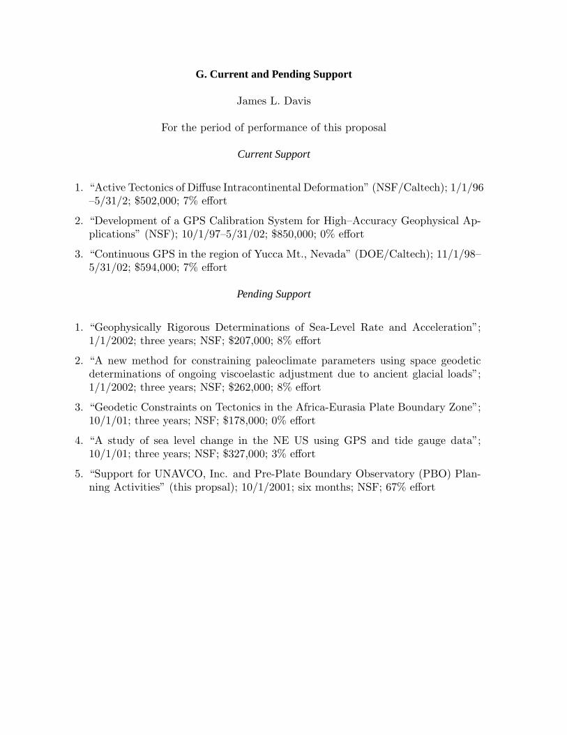
G. Current and Pending Support
James L. Davis
For the period of performance of this proposal
Current Support
1. “Active Tectonics of Diffuse Intracontinental Deformation” (NSF/Caltech); 1/1/96–5/31/2; $502,000; 7% effort
2. “Development of a GPS Calibration System for High–Accuracy Geophysical Ap-plications” (NSF); 10/1/97–5/31/02; $850,000; 0% effort
3. “Continuous GPS in the region of Yucca Mt., Nevada” (DOE/Caltech); 11/1/98–5/31/02; $594,000; 7% effort
Pending Support
1. “Geophysically Rigorous Determinations of Sea-Level Rate and Acceleration”;1/1/2002; three years; NSF; $207,000; 8% effort
2. “A new method for constraining paleoclimate parameters using space geodeticdeterminations of ongoing viscoelastic adjustment due to ancient glacial loads”;1/1/2002; three years; NSF; $262,000; 8% effort
3. “Geodetic Constraints on Tectonics in the Africa-Eurasia Plate Boundary Zone”;10/1/01; three years; NSF; $178,000; 0% effort
4. “A study of sea level change in the NE US using GPS and tide gauge data”;10/1/01; three years; NSF; $327,000; 3% effort
5. “Support for UNAVCO, Inc. and Pre-Plate Boundary Observatory (PBO) Plan-ning Activities” (this propsal); 10/1/2001; six months; NSF; 67% effort
H. Facilities, Equipment and Other Resources
For the duration of this proposal, the President's Office will be located at the Harvard-Smithsonian Center for
Astrophysics (CfA), of which the Smithsonian Astrophysical Observatory is a member. The CfA has numerous
computer facilities, including workstations, automated backup, and Internet connections, all of which and are
supported by the CfA Computation Facility. Office space is provided to all research scientists and administrative
staff. All offices contain phone and computer connections. The CfA has a library containing books and journals on
geodesy and geophysics, with access to all of Harvard University's other libraries.
Other tasks will be performed at institutions belonging to other UNAVCO, Inc. community members. These
members are universities and non-profit organizations that generally have similar facilities.