Embed Size (px)
Citation preview
PUBLIC ROAD STANDARDS
COUNTY OF SAN DIEGO DEPARTMENT OF PUBLIC WORKS
DRAFT
September 12, 2008
- ii -
PUBLIC ROAD STANDARDS COUNTY OF SAN DIEGO
TABLE OF CONTENTS
Page SECTION 1 INTRODUCTION..................................................................................................... 1
1.1 INTRODUCTION.......................................................................................................................... 1
l.2 PURPOSE....................................................................................................................................... 1
1.3 EXCEPTIONS................................................................................................................................ 1
SECTION 2 GENERAL DEFINITIONS ..................................................................................... 2 2.1 GENERAL DEFINITIONS .......................................................................................................... 2
2.2 OTHER DOCUMENTS ................................................................................................................ 4
SECTION 3 GENERAL POLICY................................................................................................. 7 3.1 PLANS TO BE APPROVED BY DIRECTOR, DEPARTMENT OF PUBLIC WORKS ...... 7
3.2 WHERE NO STANDARD IS SPECIFIED ................................................................................. 7
3.3 PAYMENTS FOR IMPROVEMENTS ....................................................................................... 7
3.4 WIDENING AND IMPROVEMENT OF EXISTING ROADS ................................................ 8
3.5 OFF-SITE WIDENING AND IMPROVEMENTS OF EXISTING OR PLANNED ROADS 8
3.6 RELOCATION AND/OR REMOVAL OF EXISTING FACILITIES..................................... 8
3.7 TRAFFIC STUDIES...................................................................................................................... 8
SECTION 4 REQUIRED PUBLIC ROAD RIGHTS-OF-WAY IMPROVEMENTS................. 9 4.1 CLASSIFICATION ....................................................................................................................... 9
4.2 ROAD CROSS-SECTIONS.......................................................................................................... 9
4.3 GENERAL NOTES ....................................................................................................................... 9
4.4 CIRCULATION ELEMENT ROADS - SUPPLEMENTAL INFORMATION .................... 11
4.5 NON-CIRCULATION ELEMENT ROADS............................................................................. 18
SECTION 5 REQUIRED ROAD IMPROVEMENTS ............................................................... 27 5.1 CURBS AND DIKES................................................................................................................... 27
5.2 SIDEWALKS ............................................................................................................................... 27
5.3 PATHWAYS ................................................................................................................................ 28
5.4 DRIVEWAYS .......................................................................................................................... 28
5.5 ROAD NAME SIGNS ............................................................................................................. 29
5.6 TRAFFIC SIGNALS, REGULATORY AND WARNING SIGNS..................................... 29
57 HIGHWAY GUARDRAIL ..................................................................................................... 29
5.8 ROADWAY LIGHTING ........................................................................................................ 30
5.9 SURVEY MONUMENTS....................................................................................................... 33
5.10 MEDIANS ................................................................................................................................ 33
5.11 DRAINAGE IMPROVEMENTS ................................................................................................ 34
- iii -
SECTION 6 DESIGN STANDARDS.......................................................................................... 38 6.1 INTERSECTIONS....................................................................................................................... 38
6.2 FUTURE ROAD EXTENSIONS................................................................................................ 39
6.3 GRADING .................................................................................................................................... 40
6.4 PAVEMENT AND STRUCTURAL SECTION........................................................................ 40
6.5 CROSS-FALL, CROWN, AND CROSS-SLOPE IN STREETS............................................. 43
6.6 UTILITY PLACEMENT ............................................................................................................ 43
6.7 DRIVEWAYS............................................................................................................................... 44
6.8 ROAD ALIGNMENTS................................................................................................................ 46
SECTION 7 BIKEWAYS............................................................................................................. 47 7.1 BIKEWAY DESIGN STANDARD ............................................................................................ 47
7.2 BIKEWAY DEFINITIONS ........................................................................................................ 47
7.3 BIKEWAY REQUIREMENTS .................................................................................................. 47
SECTION 8 PATHWAYS............................................................................................................ 48 8.1 PATHWAY DESIGN STANDARDS ......................................................................................... 48
8.2 PATHWAY DEFINITIONS ....................................................................................................... 48
8.3 PATHWAY REQUIREMENTS................................................................................................. 48
SECTION 9 MODIFICATIONS................................................................................................. 49 9.1 MODIFICATION PROCESSING PROCEDURES ................................................................. 49
INDEX.......................................................................................................................................... 51
- 1 -
SECTION 1
INTRODUCTION
Section 1.1 INTRODUCTION These Standards are for use by individuals who as a result of the land development process desire to have the Board of Supervisors accept public works improvements into the County's system of maintained public roads. Section l.2 PURPOSE The purpose of these Standards is to provide for the regulation of improvements to be dedicated to the public and accepted by the County as a result of the land development process. The Standards are intended to keep the operating cost of maintaining public facilities at a reasonable level and at the same time provide for the service and protection of the public. Section 1.3 EXCEPTIONS It is not possible to anticipate all situations that may arise and to prescribe standards applicable to every situation. These Standards will be applicable to the vast majority of cases, but they are not inflexible rules to which there is no exception. Occasionally, the Board of Supervisors or Director of Public Works may make exceptions where the application of the Standards is impractical or results in unreasonable hardship. Procedures for processing a modification request are provided in Section 9.
- 2 -
SECTION 2
GENERAL DEFINITIONS Section 2.1 GENERAL DEFINITIONS The following definitions shall be applicable to these Standards. 1. "COMMON DRIVEWAY" is a driveway shared by more than one legal lot. 2. "CROSS-FALL" is the difference in elevation of ends of a chord drawn perpendicular to the
direction of travel between opposite edges of the paved way. Its gradient is determined by dividing the difference in elevation between edges by the horizontal distance between edges, expressed as a percentage.
3. "CROSS-SLOPE" is the gradient determined by dividing the difference in elevation from
crown to pavement edge by the horizontal distance from crown to pavement edge, expressed as a percentage.
4. "CROWN" is the highest part of the road surface between pavement edges. 5. "DEVELOPER" is an owner or owner-authorized agent who seeks to change the existing
use, or improve the condition, of a property in any way. 6. "DIRECTOR" means "Director, Department of Public Works", "County Engineer” "County
Engineer and Road Commissioner", "Surveyor", "Road Commissioner" and "County Surveyor and Road Commissioner", or an authorized representative.
7. "DWELLING" means a building, or portion thereof, used exclusively for residential
purposes, including one-family, two-family, multiple dwellings, but not including hotels, boarding and lodging houses.
8. "DWELLING UNIT" is a single unit providing complete, independent living facilities for
one or more persons, including permanent provisions for living sleeping, cooking and sanitation, and having only one kitchen.
9. “ENGINEER OF WORK" means a Civil Engineer licensed to practice in the State of
California who has been authorized by the developer to prepare plans and specifications. 10. "FLOODWAY" is the main flow area of a river or other watercourse and the adjacent land
areas needed to carry the 100-year flood without increasing the water surface elevation of that flood more than one foot at any point. See Resource Protection Ordinance and Flood Damage Prevention Ordinance for other criteria that may be applicable.
11. "GRADE" is the slope of the longitudinal road profile generally measured along the
centerline, expressed as a percentage. 12. "GRADED WIDTH" means the width of the road to be graded measured from the top of the
- 3 -
bank in embankment or to the toe of the slope in excavation. All slopes shall be outside of, and not included in, the graded width.
13. "HIGHWAY" includes streets and roads. The terms street, road, and highway are used
interchangeably and refer to the rights-of-way used for vehicular traffic and, except in the case of freeways, for pedestrian traffic.
13. "INDUSTRIAL/COMMERCIAL" is applied to all roads that are used to provide access to
abutting industrial lots, or commercial lots, or both. For the purpose of these Standards, there is no differentiation between the terms "INDUSTRIAL" and "COMMERCIAL".
14. "INTERSECTION" is the area embraced within the prolongation of the lateral curb lines; or,
if none, then a) the lateral boundary lines of the roadways of two highways which join one another at approximately right angles, or b) the area within which vehicles, traveling upon different highways joining at any other angle, may come in conflict.
15. "LEVEL OF SERVICE" of a road is a measure of its vehicular capacity. Six levels of service
(A to F) are identified in the Highway Capacity Manual. Level of Service "A" is identified as "free" vehicular flow with few conflicts or interruptions. Level of Service "F" is identified as highly congested stop-and-go with many vehicular conflicts and interruptions. The level of service for a particular road is a measure of speed and travel time, traffic interruptions or restrictions, freedom to maneuver, safety, driver comfort and convenience, and economy.
16. "NUMBER OF VEHICLE TRIPS PER DAY" means the number of one way trips per day
anticipated on a street. 17. "OFFICERS" as used in these Standards, shall mean an officer, board, commission,
department, or office of the County of San Diego, unless otherwise specified. 18. "PARKWAY" is the distance measured from the curb face to the property line of a road
right-of-way. 19. “PATHWAY” is a non-motorized transportation facility located within a parkway. If a
“Riding and Hiking Multi-Use Trail” is located within the road right-of-way it is may also be considered a “Pathway”.
20. "PAVEMENT WIDTH" is the specified width of pavement of the roadbed and is measured
from curb face to curb face. In the absence of curbs, the pavement width is measured from the edges of the roadbed.
21. "RESIDENCE DISTRICT" is that portion of a highway and the property contiguous thereto,
other than a business district, (a) upon one side of which highway, within a distance of a quarter of a mile, the contiguous property fronting thereon is occupied by 13 or more separate dwelling houses or business structures, or (b) upon both sides of which highway, collectively, within a distance of a quarter of a mile, the contiguous property fronting thereon is occupied by 16 or more separate dwelling houses or business structures. A residence district may be longer than one-quarter mile if the above ratio of separate dwelling houses or
- 4 -
business structures to the length of the highway exists. 22. "RIGHT-OF-WAY" means the area distance measured between easement sidelines of the
opposite in the case of fee right-of-way. property lines of a street. It represents the area enclosed with an easement or a fee acquisition, designated for road use between private property lines which is available for provision of road improvements such as curbs and gutters, sidewalk, roadbed pavement, bike facilities, pathways, grading, drainage facilities, franchised utilities and other underground and overhead improvements.
23. "ROAD" includes streets and highways. The terms street, road, and highway are used
interchangeably and refer to the rights-of-way used for vehicular traffic and, except in the case of freeways, for pedestrian traffic.
243. "STANDARD DRAWINGS" means San Diego Area Regional Standard Drawings approved
by the Board of Supervisors and adopted by said Board as a part of these Standards. Also included are the County's Design Standard Drawings.
254. "STREET" includes roads and highways. The terms street, road, and highway are used
interchangeably and refer to the rights-of-way used for vehicular traffic and, except in the case of freeways, for pedestrian traffic.
Section 2.2 OTHER DOCUMENTS The following documents are referred to in these Standards or may be applicable and are on file in the Office of the Director. References are to current editions unless specified otherwise. 1. A Policy on Geometric Design of Highways and Streets, American Association of State
Highway and Transportation Officials (AASHTO). 2. Bicycle Transportation Plan, County of San Diego 3. California Manual on Uniform Traffic Control Devices (CA MUTCD), Caltrans 4. Community Right-of-way Development Standards ; Fallbrook, County of San Diego 5. Community Right-of-way Development Standards; Country/Town Sphere of the San
Dieguito Planning Area, County of San Diego 6. Community Right-of-way Development Standards; County Town Area of the Borrego
Springs Planning Area, County of San Diego 7. Community Right-of-way Development Standards; Julian Historic District and the
Julian Community Planning Area, County of San Diego 8. Guidelines for Determining Significance and Report Format and Content
Requirements for Transportation and Traffic, County of San Diego 9. Community Trails Master Plan, County of San Diego
- 5 -
10. Flood Control District Design & Procedure Manual, County of San Diego. 11. General Plan, County of San Diego Part 3 (Circulation Element) and Part 12 (Public
Facility Element). 12. Guide to Utility Location, San Diego Imperial Counties Chapter of the American Public
Works Association. 13. Highway Capacity Manual, Transportation Research Board, National Research Council. 14. Highway Design Manual of Instructions, CALTRANS. 15. Flood Control District Hydrology Manual, County of San Diego. (8) Manual on Uniform Traffic Control Devices for Streets and Highways, U.S. Department
of Transportation, Federal Highway Administration. (9) Planning and Design Criteria for Bikeways in California, CALTRANS. (10) Policy Establishing Criteria for the Development and Operation of a Regional and
Community Plan Non-Motorized Trails and Pathways System, Policy Number I-116, County Board of Supervisors Policy.
16. Road Policy, County of San Diego. 17. San Diego Area Regional Standard Drawings, County of San Diego. 18. San Diego County Design Standard, County of San Diego. 19. Special Provisions & Specifications for the Improvement of New Streets, County of San
Diego, Department of Public Works. 20. Standard Specifications, CALTRANS. 21. Standard Specifications for Highway Bridges, American Association of State Highway
and Transportation Officials, (AASHTO). 22. Standard Specifications for Public Works Construction and supplemental amendments,
Building News, Inc. 23. Street Light Specifications, County of San Diego. 24. Subdivision Map Act, State of California. 25. Subdivision Ordinance, County of San Diego. 26. Traffic Guidelines, County of San Diego.

- 6 -
27. Traffic Manual, CALTRANS.
- 7 -
SECTION 3
GENERAL POLICY Section 3.1 PLANS TO BE APPROVED BY DIRECTOR, DEPARTMENT OF PUBLIC
WORKS The developer shall cause to be prepared by a California Registered Civil Engineer, in accordance with these Standards, plans, profiles, and specifications for the proposed improvement of all streets, bikeways, easements, pathways, and drainage facilities. The developer shall obtain the approval of said plans, profiles, and specifications by the Director, and obtain necessary permits prior to commencing any construction. The original improvement plans, when approved, are kept on file by the Department of Public Works as a permanent public record. a. The improvement plans will be released only to bonded blueprint companies. b. Prior to construction or while the construction is active, the improvement plans may be released
to the Engineer of Work for plan changes. The Engineer of Work shall review proposed changes with the Department of Public Works before the original plans are released. No plan changes shall be used or the original plans changed until approved by the County.
c. At the completion of construction, the Engineer of Work shall prepare and submit for approval a
"record plan" showing the actual improvements constructed. Section 3.2 WHERE NO STANDARD IS SPECIFIED Where the requirements for any subdivision, major use permit, rezone, or other improvements are not covered by these Standards, such requirements shall be specified by the Planning and Environmental Review Board (PERB), Planning Commission, or Board of Supervisors, or, if not so specified, by the Director. Where the requirements for road centerlines are not specified in these Standards, such requirements shall be specified by the Director or Board of Supervisors. Section 3.3 PAYMENTS FOR IMPROVEMENTS All improvements required by these Standards shall be constructed and installed by the developer at his expense unless expressly specified by the Board of Supervisors that the County will share the expense. The developer, with the consent of the Board, may finance the construction of subdivision improvements by special assessment proceedings.
- 8 -
Section 3.4 WIDENING AND IMPROVEMENT OF EXISTING ROADS Where land abutting an existing substandard road is to be developed, the developer shall dedicate any necessary additional right-of-way and improve such road, including traffic signal improvements and modifications, traffic control devices, and drainage improvements, to conform to these Standards except as otherwise provided by ordinance. Section 3.5 OFF-SITE WIDENING AND IMPROVEMENTS OF EXISTING OR
PLANNED ROADS Where development of land requires the improvement of roads and utilities off-site of the proposed development, such improvements and rights-of-way, as required by the Board of Supervisors or their designated representatives, shall conform to these Standards. Section 3.6 RELOCATION AND/OR REMOVAL OF EXISTING FACILITIES Where removal or relocation of any overhead or underground utilities, structures, trees or plantings, etc., are necessary for a developer to accomplish road improvements within the public right-of-way, arrangements and permits for removal or relocation shall be made with all concerned or affected agencies or private parties prior to commencing any work within the public right-of-way. County shall not be held responsible for any such cost. Section 3.7 TRAFFIC STUDIES Traffic impact studies may be required to assess the potential traffic impacts of a land development project. County and/or regional policies for the preparation of traffic impact studies establish thresholds for when a traffic study is needed and when a traffic impact occurs. For instance, the County of San Diego Guidelines for Determining Significance and Report Format and Content Requirements for Transportation and Traffic should be used when preparing traffic impact studies in the County of San Diego. In addition to the criteria established within these policies, a focused traffic impact study may be required to address local and/or residential street issues.
- 9 -
SECTION 4
REQUIRED PUBLIC ROAD RIGHTS-OF-WAY IMPROVEMENTS
Section 4.1 CLASSIFICATION There are two general classifications of public roads as defined in these Standards: Circulation Element roads and Non-Circulation Element roads. The former are roads which have been adopted by the Board of Supervisors as the Regional Circulation Network for Element of the General Plan. Circulation Element Roads: Circulation Element roads are considered the regional backbone or skeleton road system. These roads provide for the vehicular movement of goods and services between various parts of the county. Non-Circulation Element Roads: These roads feed vehicular traffic onto the Circulation Element system of roads. They provide access to residential neighborhoods and commercial and industrial areas. Table No. 1 identifies specific road classifications and their normal expected carrying capacity in terms of vehicles per day at different levels of service. These capacities apply to road segments fully improved to County Standards, not those roads which are existing as partially improved or unimproved segments. The values shown are subject to adjustment based on the geometry of the roadway, side frictions, and other relevant factors as determined by the Director, Department of Public Works. Section 4.2 ROAD CROSS-SECTIONS Tables 2A and 2B are is a listing of all road requirements. The data specified in Tables 2A and 2B are minimums and are subject to modification as further defined in this section. Section 4.3 GENERAL NOTES A. Additional right-of-way width may be required to accommodate slopes, drainage structures,
bikeways, pathways, additional turning lanes and/or other required improvements. B. Where a public road is entirely within a proposed project’s boundary, the developer shall
dedicate the right-of-way required in Tables 2A and 2B, consistent with the road classification. The developer shall also grade cut slopes and construct the ultimate fill slopes and improvements. Reduced improvements may be approved if the road does not connect with an adjacent fully improved road and if it is only needed for internal circulation within the project.
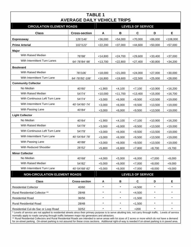
TABLE 1 AVERAGE DAILY VEHICLE TRIPS
CIRCULATION ELEMENT ROADS LEVELS OF SERVICE
Class Cross-section A B C D E
Expressway 126’/146’ <36,000 <54,000 <70,000 <86,000 <108,000
Prime Arterial 102’/122’ <22,200 <37,000 <44,600 <50,000 <57,000
Major
With Raised Median 78’/98’ <14,800 <24,700 <29,600 <33,400 <37,000
With Intermittent Turn Lanes 64’-78’/84’-98’ <13,700 <22,800 <27,400 <30,800 <34,200
Boulevard
With Raised Median 78’/106’ <18,000 <21,000 <24,000 <27,000 <30,000
With Intermittent Turn Lane 64’-78’/92’-106’ <16,800 <19,600 <22,500 <25,000 <28,000
Community Collector
No Median 40’/60’ <1,900 <4,100 <7,100 <10,900 <16,200
With Raised Median 54’/74’ <10,000 <11,700 <13,400 <15,000 <16,700
With Continuous Left Turn Lane 54’/74’ <3,000 <6,000 <9,500 <13,500 <19,000
With Intermittent Turn Lane 40’-54’/60’-74’ <3,000 <6,000 <9,500 <13,500 <19,000
With Passing Lane 40’/84’ <3,000 <6,000 <9,500 <13,500 <19,000
Light Collector
No Median 40’/64’ <1,900 <4,100 <7,100 <10,900 <16,200
With Raised Median 54’/78’ <3,000 <6,000 <9,500 <13,500 <19,000 With Continuous Left Turn Lane 54’/78’ <3,000 <6,000 <9,500 <13,500 <19,000 With Intermittent Turn Lane 40’-54’/64’-78’ <3,000 <6,000 <9,500 <13,500 <19,000 With Passing Lane 40’/88’ <3,000 <6,000 <9,500 <13,500 <19,000 With Reduced Shoulder 28’/52’ <5,800 <6,800 <7,800 <8,700 <9,700
Minor Collector
No Median 40’/68’ <4,000 <5,000 <6,000 <7,000 <8,000
With Raised Median 54’/82’ <5,000 <6,000 <7,000 <8,000 <9,000
With Intermittent Turn Lane 40’-54’/68’-82’ <5,000 <6,000 <7,000 <8,000 <9,000
NON-CIRCULATION ELEMENT ROADS LEVELS OF SERVICE
Class Cross-section A B C D E
Residential Collector 40/60 * * <4,500 * *
Rural Residential Collector ** 28/48 * * <4,500 * *
Residential Road 36/56 * * <1,500 * *
Rural Residential Road 28/48 * * <1,500 * *
Residential Cul-de-Sac or Loop Road 32/52 * * <200 * * * Levels of service are not applied to residential streets since their primary purpose is to serve abutting lots, not carry through traffic. Levels of service normally apply to roads carrying through traffic between major trip generators and attractors. ** Rural Residential Collectors and Rural Residential Roads are intended to serve areas with lot sizes of 2 acres or more which do not have a demand for on-street parking. On-street parking is not assured for these cross sections. Additional right-of-way is needed if on-street parking is in paved area.
- 11 -
C. Where a public road is adjacent to the project’s boundary, the developer shall construct any
required curbs, gutters, ditches/ and/or sidewalks and a minimum of one-half of the surfacing width specified in Table 2 for that particular road classification, but in no case less than 28 feet of paving and 40 feet of grading plus slopes.
D. Travel lanes are 12 feet wide unless otherwise specified. Section 4.4 CIRCULATION ELEMENT ROADS – SUPPLEMENTAL INFORMATION The following requirements supplement the minimum standards found in Tables 2A and 2B: A. Access
It is intended that the roads identified on the County General Plan depict corridors for public mobility and access which are planned to meet the needs of the existing and anticipated population of San Diego County. It is intended that Circulation Element roads provide public mobility with minimum interference from local traffic as it accesses a General Plan road. Therefore, Circulation Element roads require access control to minimize traffic conflicts. Access control for each Circulation Element road classification shall be as follows:
1. Expressways No lot or private road access allowed; only selected public road access with full grade
separations.
2. Prime Arterials Access is fully controlled with new development required to provide signalized
intersections for ingress and egress. Residential lots are required to be served from interior residential roads.
3. Major Roads
Access is controlled with new development required to provide access roads, common
driveways and signalized intersections. Residential lots are required to be served from interior residential roads.
4. Collector Roads/Rural Collector Roads
Access is controlled with new development required to provide common driveways, access roads and, on occasion, signalized intersections. Residential lots are required to be served from interior residential roads.
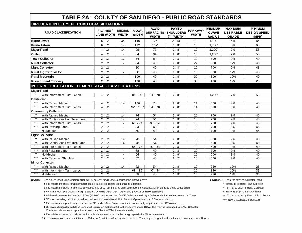
CIRCULATION ELEMENT ROAD CLASSIFICATIONS# LANES /
LANE WIDTHMEDIAN WIDTH
R.O.W. WIDTH
ROAD SURFACING
WIDTH
PAVED SHOULDERS (# / WIDTH)
PARKWAY WIDTH
MINIMUM CURVE RADIUS
MAXIMUM DESIRABLE
GRADE
MINIMUM DESIGN SPEED
(MPH)Expressway 6 / 12' 34' 146' 126' 2 / 10' 10' 1,700' 6% 65Prime Arterial 6 / 12' 14' 122' 102' 2 / 8' 10' 1,700' 6% 65Major Road 4 / 12' 14' 98' 78' 2 / 8' 10' 1,200' 7% 55Collector 4 / 12' - 84' 64' 2 / 8' 10' 1,200' 7% 55Town Collector 2 / 12' 12' 74' 54' 2 / 8' 10' 500' 9% 40Rural Collector 2 / 12' - 84' 40' 2 / 8' 22' 500' 12% 40Light Collector 2 / 12' - 60' 40' 2 / 8' 10' 700' 9% 45Rural Light Collector 2 / 12' - 60' 40' 2 / 8' 10' 500' 12% 40Rural Mountain 2 / 12' - 100' 40' 2 / 8' 30' 500' 12% 40Recreational Parkway 2 / 12' - 100' 40' 2 / 8' 30' 400' 12% 25INTERIM CIRCULATION ELEMENT ROAD CLASSIFICATIONSMajor Road
* With Intermittent Turn Lanes 4 / 12' - 84' - 98' 64' - 78' 2 / 8' 10' 1,200' 7% 55Boulevard
+++ With Raised Median 4 / 12' 14' 106' 78' 2 / 8' 14' 500' 9% 40+++ With Intermittent Turn Lanes 4 / 12' - 92' - 106' 64' - 78' 2 / 8' 14' 500' 9% 40
Community Collector** With Raised Median 2 / 12' 14' 74' 54' 2 / 8' 10' 700' 9% 45** With Continuous Left Turn Lane 2 / 12' 14' 74' 54' 2 / 8' 10' 700' 9% 45
+++ With Intermittent Turn Lanes 2 / 12' - 60' - 74' 40' - 54' 2 / 8' 10' 700' 9% 45*** With Passing Lane 2 / 12' - 84' 40' 2 / 8' 10' 700' 9% 45
+ No Median 2 / 12' - 60' 40' 2 / 8' 10' 700' 9% 45Light Collector
** With Raised Median 2 / 12' 14' 78' 54' 2 / 8' 10' 500' 9% 40** With Continuous Left Turn Lane 2 / 12' 14' 78' 54' 2 / 8' 10' 500' 9% 40
+++ With Intermittent Turn Lanes 2 / 12' - 64' - 78' 40' - 54' 2 / 8' 10' 500' 9% 40*** With Passing Lane 2 / 12' - 88' 40' 2 / 8' 10' 500' 9% 40++ No Median 2 / 12' - 64' 40' 2 / 8' 10' 500' 9% 40
+++ With Reduced Shoulder 2 / 12' - 52' 40' 2 / 2' 10' 500' 9% 40Minor Collector
+++ With Raised Median 2 / 12' 14' 82' 54' 2 / 8' 10' 350' 12% 35+++ With Intermittent Turn Lanes 2 / 12' - 68' - 82' 40' - 54' 2 / 8' 10' 350' 12% 35+++ No Median 2 / 12' - 68' 40' 2 / 8' 10' 350' 12% 35
NOTES: 1 Minimum longitudinal gradient shall be 1.0 percent for all road classificationis shown above. LEGEND: * Similar to existing Collector Road2 The maximum grade for a permanent cul-de-sac street turning area shall be 6 percent. ** Similar to existing Town Collector3 The maximum grade for a temporary cul-de-sac street turning area shall be that of the classification of the road being constructed. *** Similar to existing Rural Collector4 For standards, see County Design Standard Drawing DS-2, DS-3, DS-4, and page 21 of these Standards. + Same as existing Light Collector5 Additional pavement (4 feet) and ROW (12 feet) may be required for CE Collectors and Light Collectors in Industrial/Commercial Zones. ++ Similar to existing Rural Light Collector6 CE roads needing additional turn lanes will require an additional 12 to 14 feet of pavement and ROW for each lane. +++ New Classification Standard7 The maximum superelevation allowed on CE roads is 6%. Superelevation is not normally required on Non-CE roads.8
9 The minimum curve radii, shown in the table above, are based on the design speed with 6% superelevation.10 Interim roads are to be a minimum of 28 feet A.C. within a 40 feet graded roadbed. They may be larger if traffic volumes require more travel lanes.
TABLE 2A: COUNTY OF SAN DIEGO - PUBLIC ROAD STANDARDS
ROAD CLASSIFICATION
CE roads designated with Bike Lanes will require an additional 10 feet of pavement and ROW. This may be increased to 12' for Collector Roads and above based upon the provisions in Section 7.3 of these standards.
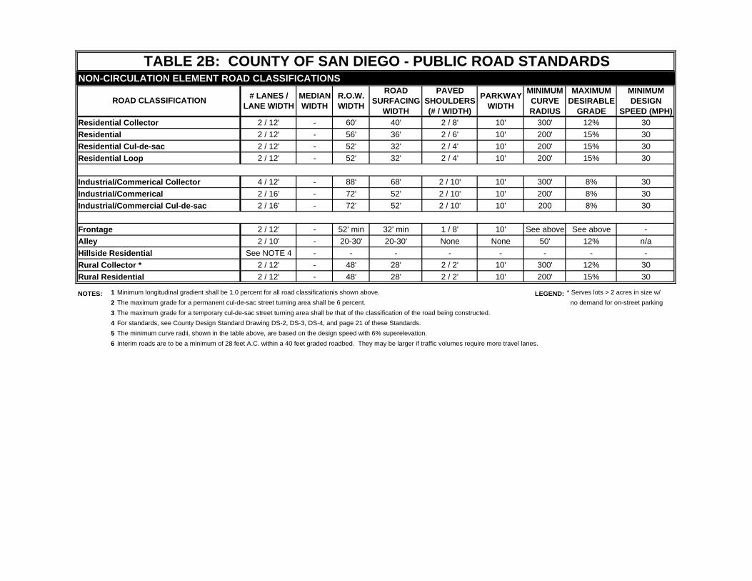
NON-CIRCULATION ELEMENT ROAD CLASSIFICATIONS
# LANES / LANE WIDTH
MEDIAN WIDTH
R.O.W. WIDTH
ROAD SURFACING
WIDTH
PAVED SHOULDERS (# / WIDTH)
PARKWAY WIDTH
MINIMUM CURVE RADIUS
MAXIMUM DESIRABLE
GRADE
MINIMUM DESIGN
SPEED (MPH)Residential Collector 2 / 12' - 60' 40' 2 / 8' 10' 300' 12% 30Residential 2 / 12' - 56' 36' 2 / 6' 10' 200' 15% 30Residential Cul-de-sac 2 / 12' - 52' 32' 2 / 4' 10' 200' 15% 30Residential Loop 2 / 12' - 52' 32' 2 / 4' 10' 200' 15% 30
Industrial/Commerical Collector 4 / 12' - 88' 68' 2 / 10' 10' 300' 8% 30Industrial/Commerical 2 / 16' - 72' 52' 2 / 10' 10' 200' 8% 30Industrial/Commercial Cul-de-sac 2 / 16' - 72' 52' 2 / 10' 10' 200 8% 30
Frontage 2 / 12' - 52' min 32' min 1 / 8' 10' See above See above -Alley 2 / 10' - 20-30' 20-30' None None 50' 12% n/aHillside Residential See NOTE 4 - - - - - - - -Rural Collector * 2 / 12' - 48' 28' 2 / 2' 10' 300' 12% 30Rural Residential 2 / 12' - 48' 28' 2 / 2' 10' 200' 15% 30
NOTES: 1 Minimum longitudinal gradient shall be 1.0 percent for all road classificationis shown above. LEGEND: * Serves lots > 2 acres in size w/2 The maximum grade for a permanent cul-de-sac street turning area shall be 6 percent. no demand for on-street parking3 The maximum grade for a temporary cul-de-sac street turning area shall be that of the classification of the road being constructed.4 For standards, see County Design Standard Drawing DS-2, DS-3, DS-4, and page 21 of these Standards.5 The minimum curve radii, shown in the table above, are based on the design speed with 6% superelevation.6 Interim roads are to be a minimum of 28 feet A.C. within a 40 feet graded roadbed. They may be larger if traffic volumes require more travel lanes.
TABLE 2B: COUNTY OF SAN DIEGO - PUBLIC ROAD STANDARDS
ROAD CLASSIFICATION
- 14 -
5. Collector Roads/Rural Collector Roads
Access is controlled with new development required to provide common driveways, access roads and, on occasion, signalized intersections. Residential lots are required to be served from interior residential roads.
6. Community Collector
Access is controlled with new development required to provide common driveways, access roads and, on occasion, signalized intersections. Residential lots are required to be served from interior residential roads.
7. Boulevard
Access is controlled with new development required to provide common driveways,
access roads and, on occasion, signalized intersections. Residential lots are required to be served from interior residential roads.
8. Town Collector Roads
Access is controlled with new development required to provide common driveways, access roads or signalized intersections. Residential lots are required to be served from interior residential roads. Commercial areas are required to provide driveway separation as identified in Section 6.1.C.2 as if the driveways were Non-Circulation Element roads.
9. Light Collector Roads/Rural Light Collector Roads
Access is generally controlled, with subdivisions and commercial developments required
to provide access roads and common driveways respectively. Residential lots are required to be served from interior residential roads, where possible.
10. Minor Collector
Access is generally controlled. Lots in subdivisions are required to be served from
interior residential roads. Commercial areas are required to be provided with common driveways for access.
10. Recreational Parkways/Rural Mountain Roads
Access is generally controlled. Lots in subdivisions are required to be served from
interior residential roads. Commercial areas are required to be provided with common driveways for access.
- 15 -
B. Intersections
Intersectional sight distance shall have priority over all other standards and shall be achieved within standard right-of-way.
In general, at the intersection of Circulation Element roads, the right-of-way and improvement requirements of each leg of the intersection may be changed to the next higher road classification or to a special intersection design based on a traffic analysis of the intersection.
In the event a subdivision creates traffic requiring the construction of additional turning
lanes and other safety features at a designated intersection, the subdivider shall construct or reconstruct such intersection.
C. Additional Turn Lanes
1. Prime Arterial and Expressway, if not grade separated Where the left turn traffic volume is estimated to exceed 300 vehicles at peak hour, an
additional 12 feet of right-of-way may be required for provision of a dual left turn lane. Minimum length of the additional left turn lane shall be 300 feet plus appropriate taper.
2. Major Road/Town Collector Road Where the left turn traffic volume at an intersection on the above Circulation Element
road is estimated to exceed 300 vehicles at peak hour, an additional 12 feet of right-of-way shall be required for provision of a dual left turn lane. Minimum length of the additional left turn lane shall be 300 feet plus appropriate taper.
3. Community Collector with raised medians/Boulevards with raised medians
Where the left turn traffic volume at an intersection on the above Circulation Element
road is estimated to exceed 300 vehicles at peak hour, an additional 12 feet of right-of-way shall be required for provision of a dual left turn lane. Minimum length of the additional left turn lane shall be 300 feet plus appropriate taper.
4. Community Collector without raised medians/Boulevards without raised medians
Where a the above Circulation Element road Collector road intersects another
Circulation Element road or where a left turn lane is specified, an additional 14 feet of right-of-way shall be required to provide a left turn lane. Minimum length of the additional left turn lane shall be 250 feet plus appropriate taper.
- 16 -
5. Rural Collector/Rural Mountain Roads
Where these roads intersect another Circulation Element road or where a left turn lane is
specified, an additional 14 feet of right-of-way shall be required to provide a left turn lane. Minimum length of the additional left turn lane shall be 250 feet plus appropriate taper.
6. Light Collector/Rural Light Collector Roads/Minor Collector Where these roads intersect another Circulation Element road or where a left turn lane is
specified, an additional 14 feet of right-of-way shall be required to provide a left turn lane. Minimum length of the additional left turn lane shall be 200 feet plus appropriate taper.
D. Boulevards Boulevards are four-lane roads with a wider parkway width (14 feet) that may be most
suitable in village and town center areas with a high demand for pedestrian travel or rural areas with steep topography.
DE. Town Collector Roads Town collector roads are two lane divided roads to control access and turning movements in
commercial or higher density residential areas. These roads are appropriate only in villages and rural villages country towns and other multi-residential and commercial areas as determined by the Director or by the Board of Supervisors. This determination may be based upon existing and/or future traffic volumes, the number of existing and/or future access points (such as driveways and private streets), length of road and other similar factors.
EF. Community Collector Community Collectors are two-lane roads with variable right-of-way and improvement
widths, as specified in Table 2. Variations for the Community Collector include the provision of raised medians, continuous two-way left turn lanes, intermittent turn lanes, passing lanes and undivided two lanes roads. A right-of-way width of up to 84 feet may be obtained and may be most suitable for two-lane State highways where future passing lanes may be provided.
G Minor Collector Minor Collectors are two-lane roads with variable right-of-way and improvement widths, as
specified in Table 2. Variations for the Minor Collector include the provision of raised medians, intermittent turn lanes, passing lanes and undivided two lanes roads. A right-of-way width of up to 82 feet may be obtained with a parkway width of 14 feet. The wider parkway width may be utilized in rural areas to improve visibility, improve tight curves
- 17 -
and/or grade slopes. In villages and town centers the wider parkway may be utilized for landscape buffers and/or to enhance pedestrian and bicycle circulation.
EH. Rural Collector and Rural Mountain Roads
Rural Collector and Rural Mountain roads are two lanes undivided roads preserving right-of-way of 84 feet and 100 feet respectively with additional right-of-way required at intersections. These roads are appropriate only in rural mountain areas with unique scenic and historic resources.
A Rural Collector road, or a Rural Mountain road, shall be designed with the traveled way placed within the right-of-way so as to minimize the physical impact on the terrain, vegetation, scenic features, and wildlife habitats. A developer shall construct, in accordance with standard drawings, any required dikes or curbs and gutters, and a minimum of 40 feet of pavement width. Where Rural Collector roads or Rural Mountain roads abut property zoned commercial, industrial, or multiple residential, appropriate commercial or industrial standards shall be constructed by the developer.
FI. Recreational Parkway
Recreational Parkway is a road which serves rural recreational traffic. Such a road is to be designed for pleasure travel in keeping with the rural or recreational setting that it traverses and serves.
Recreational Parkways shall be designed and improved as follows:
1. Right-of-way width for a Recreational Parkway shall be a minimum of 100 feet, except
where such a road is included in a publicly-owned recreational facility the right-of-way width will be adjusted to include only the roadbed width plus appurtenant facilities.
2. The pavement width shall be a minimum of 40 feet. When travel in opposite directions
is to be separated to accommodate terrain or other important natural features, the surfaced traveled way shall be a minimum width of 24 feet for each direction.
Increased pavement widths will be required in such cases where the Director finds that
such an increase is necessary to provide for the safe and free flow of traffic to enhance the recreational and pleasure driving aspects of the Recreational Parkway.
3. View site parking and roadside stopping areas shall be an integral part of the design and
function of a Recreational Parkway. Where appropriate, paved roadside stopping areas with parking shall be provided. Proposed parking and roadside stopping areas shall have been reviewed and approved by each appropriate public agency when such Recreational Parkway traverses a recreational facility possessed by such public agency.
- 18 -
GJ. Interim Road
Standards for this classification of road are specified in Table 2, Note 10. The exception to the standard is at intersections. A 40-foot pavement width instead of 28-foot pavement width will be required along the road and shall extend a minimum of 200 feet with appropriate taper in each direction from the centerline of the street intersection. Appropriate graded width shall be provided. Interim roads larger than 28 ft. A.C. within 40 ft. graded roadbed may be required if the anticipated traffic volumes are greater than can be safely accommodated on the minimum size road.
Section 4.5 NON-CIRCULATION ELEMENT ROADS A. Residential Collector Road
A residential collector road is provided to collect local traffic from adjacent residential lots. Such roads are not envisioned as providing for through traffic generating in one community and destined for another. They are designed to accommodate local traffic volumes of between 1,500 and 4,500 average daily trips. A residential collector shall be provided as follows:
1. Right-of-way width shall be 60 feet.
2. Pavement width between the curb faces shall be 40 feet.
3. Knuckles may not be used. B. Rural Residential Collector
A rural residential collector is intended to serve an area with lots sizes of 2 acres or more where there is little demand for on-street parking. A rural residential collector road is provided to collect local traffic from adjacent residential lots. Such roads are not envisioned as providing for through traffic generating in one community and destined for another. They are designed to accommodate local traffic volumes of between 1,500 and 4,500 average daily trips. A rural residential collector shall be provided as follows:
1. Right-of-way width shall be 48 feet.
2. Pavement width between the curb faces shall be 28 feet.
3. Knuckles may not be used.
- 19 -
C. Residential Road
A residential road shall provide access to the residential lots it passes by and abuts. It is not to be used in those instances where a road may be expected to serve in the future as a residential collector road. This road shall be used in those instances where the projected average daily vehicular traffic is not expected to exceed 1,500 trips. A residential road shall be provided as follows: 1. Right-of-way width shall be 56 feet.
2. Pavement width between the curb faces shall be 36 feet.
3. Knuckles may be used following the criteria shown on the County Standard Drawing.
4. Residential roads which are temporarily dead-ended shall end in a temporary cul-de-sac as shown on the County Standard Drawings unless the length is 200 feet or less, in which case no temporary cul-de-sac will be required.
D. Rural Residential Road
A rural residential road is intended to serve an area with lots sizes of 2 acres or more where there is little demand for on-street parking. A rural residential road shall provide access to the residential lots it passes by and abuts. It is not to be used in those instances where a road may be expected to serve in the future as a residential collector road. This road shall be used in those instances where the projected average daily vehicular traffic is not expected to exceed 1,500 trips. A residential road shall be provided as follows: 1. Right-of-way width shall be 56 feet.
2. Pavement width between the curb faces shall be 36 feet.
3. Knuckles may be used following the criteria shown on the County Standard Drawing.
4. Residential roads which are temporarily dead-ended shall end in a temporary cul-de-sac as shown on the County Standard Drawings unless the length is 200 feet or less, in which case no temporary cul-de-sac will be required.
E. Residential Cul-De-Sac Road
A residential cul-de-sac is a dead-end road which provides access to adjacent residential lots. Residential cul-de-sac roads are to provide vehicular access where the projected average daily vehicular trips arc below 400. Residential cul-de-sacs roads shall be provided as follows:
1. Right-of-way shall be 52 feet.
2. Pavement width between the curb faces shall be 32 feet.
- 20 -
3. Minimum radius of the cul-de-sac shall be 38 feet to curb within a 48- foot radius of
right-of-way.
4. Knuckles may be used following the criteria shown on the County Standard Drawing.
5 Residential cul-de-sacs roads are not to exceed 600 feet in length. F. Residential Loop Road
A residential loop road is a local purpose road which is to accommodate a maximum of 200 projected average daily vehicular trips. Residential loop roads shall be provided as follows:
1. Right-of-way shall be 52 feet.
2. Pavement width between the curb faces shall be 32 feet.
3. Knuckles may be used following the criteria shown on the County Standard Drawing.
5. Loop roads in excess of 600 feet shall be constructed to residential or residential
collector standards in accordance with projected average daily vehicle trips. E. Industrial/Commercial Collector Road
This road shall provide access to abutting lots zoned for industrial or commercial purposes and also collect traffic from intersecting industrial roads, commercial roads, or collector roads, or roads which provide access to property which has an area of more than five acres and is zoned for commercial purposes, or which will be required to carry more than 4,500 average daily vehicular trips. Industrial/Commercial collector roads shall be provided as follows:
1. Right-of-way shall be 88 feet.
2. Pavement width between the curb faces shall be 68 feet.
3. Knuckles may not be used.
F. Industrial/Commercial Road
This road shall provide access to abutting industrial/commercial lots where the projected average daily vehicular trips are less than 4,500. Industrial/Commercial roads shall be provided as follows:
1. Right-of-way width shall be 72 feet.
2. Pavement width between the curb faces shall be 52 feet.
3. Knuckles may be used following the criteria shown on the County Standard Drawing.
- 21 -
G. Industrial/Commercial Loop Road
An industrial/commercial loop road may be used in those instances where the projected average daily vehicular trips are less than 4,500. Industrial/Commercial loop roads shall be provided as follows:
1. Right-of-way width shall be 72 feet.
2. Pavement width between the curb faces shall be 52 feet.
3. Knuckles may be used following the criteria shown on the County Standard Drawing.
H. Industrial/Commercial Cul-De-Sac Road
An industrial/commercial cul-de-sac is a dead-end road which terminates in a cul-de-sac and provides access to abutting lots zoned for industrial or commercial purposes. Industrial/Commercial cul-de-sacs shall be used where the projected average daily vehicular trips do not exceed 1,000. Industrial/Commercial cul-de-sac roads shall be provided as follows:
1. Right-of-way width shall be 72 feet. 2. Pavement width between the curb faces shall be 52 feet.
3. The maximum length shall be 1,200 feet.
4. The cul-de-sac shall have a minimum 60 feet property line radius.
5. The cul-de-sac shall be paved to a radius of 50 feet.
6. Knuckles may be used following the criteria shown on the County Standard Drawing.
I. Half-Width Road (Boundary Road)
This road classification is for a road lying along a subdivision boundary for which only part of the right-of -way is to be presently dedicated and improved.
1. Right-of-Way
a. When the half-width road is a residential street, residential collector road,
industrial road, or commercial road, the minimum right-of-way width shall be 40 feet. In addition, the half-width road shall have a one-foot strip of land adjacent to and along the project boundary to which the access rights shall be waived.
b. For all other roads, minimum right-of-way shall be 40 feet or one-half of the
- 22 -
ultimate right-of-way width, whichever is greater. In addition, the half-width road shall have a one-foot strip of land adjacent to and along the project boundary to which access rights shall be waived.
2. Surfaced roadbed shall be 28 feet in width, or one-half of the surfaced improvement that
would be required for the development of the road at its ultimate width, whichever is greater.
J. Frontage Road
A frontage road is a road which is auxiliary to and located adjacent to a railroad, freeway, major highway, or arterial street, and which provides service to abutting property and adjacent areas and provides access control to the adjacent facility. A frontage road may be of any classification.
1. Right-of-way for the frontage road shall equal the standard right-of-way for whatever
classification the frontage road is, less 4 to 1 0 feet, but in no event shall it be less than 52 feet.
2. Pavement width of the frontage road shall be equal to the improved width for whatever
classification the frontage road is, less one eight-foot shoulder, but in no event shall the pavement width be less than 28 feet.
K. Alley
1. No new alleys shall be accepted into the County's maintained road system.
2. Alleys are to be privately maintained.
3. Existing alleys shall be as follows:
a. Right-of-way shall be a minimum of 20 feet and a maximum of 30 feet in width.
b. The intersection of an existing alley with a road shall provide adequate sight
distance.
c. Alleys shall not intersect.
d. Pavement width shall be the full width of the right-of-way, except at intersections of roads, where curb returns with radii equal to the curb-to-property-line dimension shall be constructed.
e. Pavement for alleys shall be portland cement concrete (P.C.C.).
- 23 -
L. Interim Road
Standards for this classification of road are specified in Table 2, Note 10. The exception to the standard is at intersections. A 40-foot pavement width instead of 28-foot pavement width will be required along the road and shall extend a minimum of 200 feet with appropriate taper in each direction from the centerline of the street intersection. Appropriate graded width shall be provided. Interim roads larger than 28 ft. A.C. within 40 ft. graded roadbed may be required if the anticipated traffic volumes are greater than can be safely accommodated on the minimum size road.
M. Split-Level Road
A split-level road is a road of any classification providing the improvements and capacity provided in a normal road of the same classification but with each direction of traffic provided for at different elevations and separated by a median. Right-of-way shall be as follows:
1. The typical right-of-way section for a split-level road shall provide for the same parkway
strip, parking lanes, traveled way, and turning lane area required for a normal road of the same classification and, in addition, shall provide:
a. A shoulder, at least two feet in width, along the median (edge nearest centerline) of
the lower roadway.
b. A strip at least four feet in width along the median edge of the upper roadway. In this strip the concrete curb or asphalt concrete dike, or approved barrier, shall be installed in those locations where they are required. Guardrail and/or retaining wall shall be required on the median side of the upper roadway when the difference in road level elevation exceeds 10 feet
c. An additional width sufficient to permit construction of the cut or fill slope without
exceeding the safe slope angle determined from soil tests. In the case of vertical or near vertical cuts in rock material, an approved barrier shall be required on the median side of upper roadway. A shoulder at least 10 feet wide or an approach barrier shall be required on the median side of the lower roadway.
2. The width of the dedicated right-of-way shall not be less than the sum of the foregoing
widths. N. Hillside Residential Street
To encourage the orderly development of steep areas, certain deviations from the normal standards for subdivision streets will be permitted as shown on County Design Standard Drawings or as specified herein.
The narrower roadway sections provided in the hillside standards outlined below for category 1 hillside standards and category 2 hillside standards have a reduced capacity for traffic and on-road parking. Their use is therefore limited to residential roads in areas where
- 24 -
the natural slope exceeds 15 percent and where at least 80 percent of the lots have a net area of not less than 20,000 square feet.
1. Category 1 hillside standards are identified as applying to those areas where the natural
slope is between 15 and 20 percent. The method of determining the percent slope for a category 1 hillside development is as
follows:
a. Tabulate the cross-sections with slopes which are 15 percent or less.
b. Tabulate the cross-sections with slopes which are l5 percent or greater but less than 20 percent.
c. Add the lengths (L1) for cross-sections computed in a. above.
d. Add the lengths (L2) for cross-sections computed in b. above.
e. Perform calculation: L2 - (L1 + L2) x 100 = "X" percent.
f. If the "X" is 50 or greater, this meets category 1 hillside standards.
2. Category 2 hillside standards are identified as applying to those areas where the natural slope exceeds 20 percent.
The method of determining the percent slope for a category 2 hillside development is as
follows:
a. Tabulate the cross-sections with slopes which are 20 percent or less.
b. Tabulate the cross-sections with slopes which are 2O percent or greater than 20 percent.
c. Add the lengths (L1) for cross-sections computed in a. above.
d. Add the lengths (L2) for cross-sections computed in b. above.
e. Perform calculation: L2 - (L1 + L2) x 100 = "X" percent.
f. If the "X" is 50 or greater, this meets category 2 hillside standards.
3. Calculation comments for 1 and 2 above are as follows:
a. Cross-sections shall be taken normal to the contour lines.
b. The cross-sections shall be taken at uniform 50-foot intervals.
c. Width of cross-sections shall be the limits of the proposed grading.
- 25 -
d. Only one set of standards will be used for a road between intersections.
4. Category 1 hillside standards are as follows:
a. Permissible street grades shall be increased to maximum of 20 percent grade.
b. The graded road width may be reduced a maximum of 5 feet in either or both
parkway areas.
c. Street grades in excess of 15 percent shall not exceed 600 feet in length.
5. Category 2 hillside standards will allow utilization of any of the alternatives set forth as follows:
a. Hillside residential two-way street alternatives 1, 2 and 3 are shown on County
Design Standard Drawings.
b. Minimum right-of-way for hillside streets is shown on the County Design Standard Drawings. Additional slope rights may be required to accommodate a particular situation.
c. Hillside residential one-way street:
(1) A section providing one 14-foot driving lane and one continuous 8-foot
parking lane. (2) Minimum pavement width shall be 22 feet curb to curb.
(3) Minimum graded area shall be 30 feet wide.
(4) Minimum right-of-way shall be 38 feet wide.
(5) Maximum length between connections to crossing two-way streets shall be
1,200 feet.
(6) Where one-way streets are allowed, street pattern shall provide for return to point of origin in less than one mile.
d. Hillside residential streets that require a cul-de-sac shall be designed and improved
by the developer in accordance with this section and the following:
(1) The minimum property line radius for the turning circle shall be 40 feet. (2) The turning circle shall be paved to a radius of at least 30 feet.
e. Minimum horizontal curve radius shall be sufficient to provide a safe speed of at
least twenty-five miles per hour in accordance with the current applicable section
- 26 -
or figure of the Highway Design Manual of Instructions. On minimum or near- minimum curves, pavement widening shall be provided in accordance with the
current applicable section or figure of the Highway Design Manual of Instructions.
7. Where a hillside residential street is authorized to serve a development meeting the definition of a residence district, Section 5.2 will be modified to provide for a 5-foot wide concrete sidewalk, concrete curb and gutter, and a two-foot wide graded area outside of the edge of the sidewalk.
- 27 -
SECTION 5 REQUIRED ROAD IMPROVEMENTS
Section 5.1 CURBS AND DIKES A. Portland cement concrete (P.C.C.) curbs and gutters and cross gutters conforming to San
Diego Area Regional Standard Drawings shall be provided on all roads constructed to their ultimate width and location. Where adequate right-of-way is provided, rolled curbs may also be considered.
B. Asphalt concrete (A.C.) dikes conforming to San Diego Area Regional Standard Drawings
shall be constructed by the developer on all of the following roads:
1. All roads with asphalt concrete paving where P.C.C. curbs and gutters are not constructed.
2. Along the exterior edge of any half-width road.
Section 5.2 SIDEWALKS A. P.C.C. sidewalks conforming to San Diego Area Regional Standard Drawings shall be
constructed in (a) areas designated for commercial, industrial, or multiple-residential uses, (b) in areas designated for single-family or two-family residential use where the lot size designator is less than 1/2 acre, and (c) in areas where the property is designated such that development or potential development qualifies it or will qualify it as a residence district except where a pathway is proposed on an adopted community or regional trails plan or would connect to an existing pathway.
(B) Sidewalks shall be contiguous to the curb except where guardrail is to be installed in line
with the face of curb. B. Sidewalks shall be 5.0 feet in width. A 1.5 feet wide by 0.5 feet thick P.C.C. maintenance
walkway shall be installed adjacent to the curb in those instances when non-contiguous sidewalks are approved.
C. Wheelchair ramps shall be constructed at all curb returns and other locations as required.
The ramps shall be constructed entirely within the right-of-way. D. In lieu of constructing P.C.C. sidewalks on those roads where the lots are 1/2 acre or larger,
a minimum 4-inch thick disintegrated granite (D.G.) walkway, 5 feet wide, unless shown on an adopted trails plan, shall be constructed contiguous to the A.C. dike or P.C.C curb. If shown on an adopted trails plan, then a minimum 10 foot wide pathway shall be provided and the pathway shall conform to the Community Trails Master Plan Design and Construction Guidelines as set forth in the Community Trails Master Plan.
- 28 -
Section 5.3 PATHWAYS A. Pathways conforming to Community Trails Master Plan Design and Construction Guidelines
San Diego Regional Standards Drawings may be constructed in public rights-of-way where shown on adopted trail plan maps. They may also be provided when nominated by Community Planning or Sponsor Group and selected by the Director of Public Works.
B. Pathways shall include a minimum 10 foot wide graded area between the back of road curb
or berm and the right-of-way line. Vertical (overhead) clearance shall be a minimum of 10 feet.
C. Where, per the Community Trails Master Plan, pathways are required to be greater than 10
feet wide, additional right-of-way may be necessary to provide the wider pathway. D. Pathways shall be constructed in lieu of P.C.C. sidewalks, and shall be a minimum of 5 feet
wide, unless shown on an adopted trails plan, comprised of a minimum 4-inch thick disintegrated granite (DG) tread contiguous to the A.C. dike or P.C.C. curb. . If shown on an adopted trails plan, then a minimum 10 foot wide pathway shall be provided and the pathway shall conform to the Community trails master Plan Design and Construction Guidelines as set forth in the Community Trails Master Plan.
D. Pathways shall be contiguous to the curb except where guardrail is to be installed in line with
the face of the curb. E. For sections of pathways with the following features, a fencing material acceptable to the
Director shall be installed along the right-of-way boundary:
1. The pathway is adjacent to down slope gradients of 1.5 horizontal to 1.0 vertical or greater, and
2. There is a vertical differential of at least 5 feet, and 3. The vertical differential continues parallel along the pathway for a distance greater
than or equal to 30 feet. F. Depending on site-specific conditions, the Director may require the installation of reflective
delineators (pathway markers) bearing a County trail decal along the right-of-way boundary. If required, markers will be placed at an equal distance from the face of curb and spaced at 300 foot intervals, unless specified otherwise.
G. In areas with parkway widths of 15 feet or greater, pathways will be constructed contiguous
to the outer limit of the right-of-way. Section 5.4 DRIVEWAYS All driveway construction shall conform to San Diego Area Regional Standard Drawings and San Diego County Design Standards. A. Residential Driveways are:
Driveways serving property used solely as a single-family or double-family residence,
- 29 -
including farms or ranches not used for retail outlets. B. Commercial Driveways are:
All driveways other than residential driveways. C. All commercial driveways or driveways serving multiple residences larger than duplex shall
provide for adequate sight distance. Section 5.5 ROAD NAME SIGNS A. The developer shall install road name signs as a part of the improvements. Installation shall
be in accordance with design standards. B. One sign at each intersection will be required, except on four-lane roads, where two signs
will be required. Section 5.6 TRAFFIC SIGNALS, REGULATORY AND WARNING SIGNS The developer shall install all necessary regulatory and warning signs at locations specified by the Director as a part of the road improvements. A developer may be required to install or participate in the installation of necessary traffic signals. Equestrian activated buttons shall be included during the installation of new traffic signals along pathway alignments. Section 5.7 HIGHWAY GUARDRAIL Guardrail is installed to reduce the severity of run-of-the road accidents. This is accomplished by redirecting a vehicle away from embankment slopes or fixed objects and dissipating the energy of the errant vehicle. Guardrail, however, will reduce accident severity only for those conditions where striking the guardrail is less severe than going down an embankment or striking a fixed object. Guardrail should only be used where it is clear that accident severity will be reduced. The developer shall install highway guardrail at locations described as follows: A. On embankments when it is determined that the installation of the guardrail will decrease the
potential accident severity at a particular location, as described in Chapter 7 of the CALTRANS Traffic Manual.
B. At locations where adverse conditions exist which may be alleviated by the installation of
guardrail. A minimum of 2 feet of fill shall be provided between guardrail posts and the hinge point of fill slopes. Guardrail, when installed, should be placed as far as possible from the edge of pavement. Guardrail adjacent to fixed objects should be placed no closer than 4 feet from the object unless guardrail
- 30 -
stiffening is provided. Guardrail near fixed objects should be located as identified in Figure 7.3 of the Caltrans Traffic Manual. If guardrails are to be placed adjacent to designated pathways, additional right-of-way may be necessary to provide the minimum 10-foot wide pathway. Guardrail returns (terminal sections) shall not protrude into the pathway. Section 5.8 ROADWAY LIGHTING A. GENERAL ROADWAY LIGHTING REQUIREMENTS
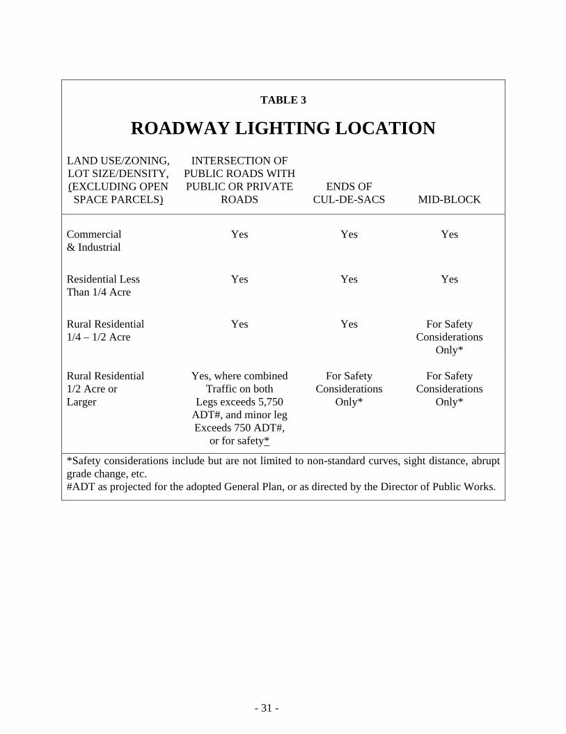
1. All developments shall provide street lighting at locations as indicated in Table 3 below:
2. All development projects will be required to transfer to Zone A of the San Diego County
Street Lighting District.
3. Tentative Maps may have off-site lighting requirements based on the above chart.
4. Tentative Parcel Maps will not have off-site lighting requirements.
- 31 -
TABLE 3
ROADWAY LIGHTING LOCATION LAND USE/ZONING, LOT SIZE/DENSITY, (EXCLUDING OPEN SPACE PARCELS)
INTERSECTION OF PUBLIC ROADS WITH PUBLIC OR PRIVATE
ROADS
ENDS OF CUL-DE-SACS
MID-BLOCK
Commercial & Industrial
Yes
Yes
Yes
Residential Less Than 1/4 Acre
Yes
Yes
Yes
Rural Residential 1/4 – 1/2 Acre
Yes
Yes
For Safety
Considerations Only*
Rural Residential 1/2 Acre or Larger
Yes, where combined
Traffic on both Legs exceeds 5,750
ADT#, and minor leg Exceeds 750 ADT#,
or for safety*
For Safety
Considerations Only*
For Safety
Considerations Only*
*Safety considerations include but are not limited to non-standard curves, sight distance, abrupt grade change, etc. #ADT as projected for the adopted General Plan, or as directed by the Director of Public Works.
- 32 -
B. ROAD LIGHTING STANDARDS
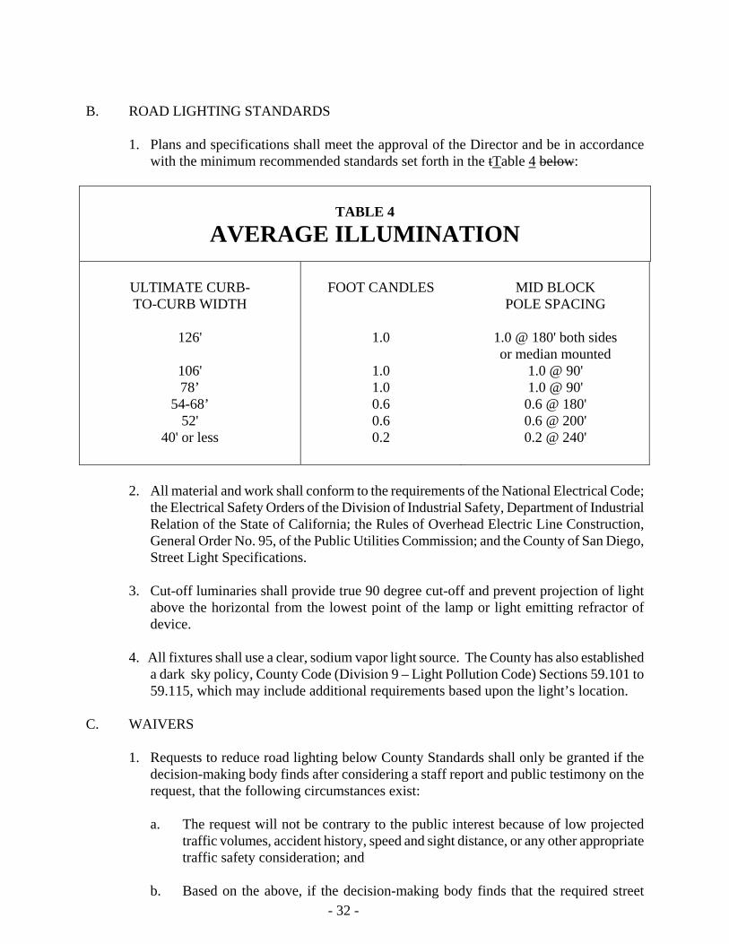
1. Plans and specifications shall meet the approval of the Director and be in accordance with the minimum recommended standards set forth in the tTable 4 below:
TABLE 4
AVERAGE ILLUMINATION
ULTIMATE CURB- TO-CURB WIDTH
126'
106' 78’
54-68’ 52'
40' or less
FOOT CANDLES
1.0
1.0 1.0 0.6 0.6 0.2
MID BLOCK
POLE SPACING
1.0 @ 180' both sides or median mounted
1.0 @ 90' 1.0 @ 90' 0.6 @ 180' 0.6 @ 200' 0.2 @ 240'
2. All material and work shall conform to the requirements of the National Electrical Code; the Electrical Safety Orders of the Division of Industrial Safety, Department of Industrial Relation of the State of California; the Rules of Overhead Electric Line Construction, General Order No. 95, of the Public Utilities Commission; and the County of San Diego, Street Light Specifications.
3. Cut-off luminaries shall provide true 90 degree cut-off and prevent projection of light
above the horizontal from the lowest point of the lamp or light emitting refractor of device.
4. All fixtures shall use a clear, sodium vapor light source. The County has also established
a dark sky policy, County Code (Division 9 – Light Pollution Code) Sections 59.101 to 59.115, which may include additional requirements based upon the light’s location.
C. WAIVERS
1. Requests to reduce road lighting below County Standards shall only be granted if the decision-making body finds after considering a staff report and public testimony on the request, that the following circumstances exist:
a. The request will not be contrary to the public interest because of low projected
traffic volumes, accident history, speed and sight distance, or any other appropriate traffic safety consideration; and
b. Based on the above, if the decision-making body finds that the required street
- 33 -
lighting is justified for the ultimate stage of development in an area, but may be premature for current development, it may determine that the facilities shall be required, deferred and secured by a cash deposit or an agreement to provide the
street lighting system at a future date. If the ultimate street improvements are to be installed, then the underground facilities and lights shall be installed.
D. ACCEPTANCE OF ROAD LIGHTING SYSTEM
The required lighting system shall be installed according to plan. The Public Works Department shall administer the compliance procedures to assure proper installation and continued operation.
Section 5.9 SURVEY MONUMENTS Survey monuments shall be installed as a part of a subdivision or road improvements in accordance with the San Diego Area Regional Standard Drawings. Section 5.10 MEDIANS A. Raised medians shall be constructed with P.C.C. curbs and shall be surfaced, unless
paragraph C applies. Painted medians, median openings, and related left-turn storage and acceleration lanes may be permitted under special circumstances.
B. All median strips shall be surfaced, and include appropriate structural section as specified by
the Director. C. Where landscaped medians are approved, an adequate drainage system shall be provided to
handle irrigation and surface water. Additionally, a 1.5 feet wide by 0.5 feet thick P.C.C. maintenance walkway shall be installed adjacent to the curbs.
D. Additional right-of-way must be provided for medians on roads which do not have medians
as part of their standard cross-section. E. The following warrants for median openings are established to facilitate traffic movement
and safety:
1. Median openings may be permitted at all intersections with public roads, except where such openings may impair the movement of traffic or are judged by the Traffic Engineer to create other traffic problems.
2. Mid-block median openings or other openings with turns permitted into adjacent
driveways or alleys shall not be permitted unless both the following conditions exist:
a. The property to be served is a major traffic generator.
b. The median opening will not interfere with an adjacent street intersection operation.
- 34 -
Section 5.11 DRAINAGE IMPROVEMENTS A. The following references are applicable:
1. The design standards and specifications applicable to flood control and drainage plans is the San Diego County Flood Control District Design & Procedure Manual.
2. The hydrologic procedures applicable to flood analysis is the San Diego County Flood
Control District Hydrology Manual.
3. The standard drawings of flood control and drainage facilities and appurtenances are the San Diego Area Regional Standard Drawings.
B. Standard Drainage System
The developer shall submit a drainage study, plans and specifications for improvements of all drainage easements, culverts, drainage structures, and drainage channels to the Department of Public Works for approval. Unless specifically waived herein, such plans and specifications shall provide a drainage system capable of handling and disposing of all surface waters originating within the subdivision and all surface waters that may flow onto the subdivision from adjacent lands. Said drainage system shall include any easements and structures required by the Department of Public Works to properly handle the drainage on-site and off-site.
C. Design Runoff
Design runoff shall be based on the criteria specified in the Flood Control District Design & Procedure Manual.
D. Type of Storm Drain System
1. Lots of one acre or less (as permitted by the General Plan): Open channels shall be concrete lined. Closed conduits are required to accommodate all flows which can be carried by a pipe of 48 inches or smaller diameter.
2. Lots over one acre (as permitted by the General Plan): Natural drainage channels are permitted where the channel does not create health, safety,
drainage, or flood problems. 3. Refer to the Resource Protection Ordinance and Flood Control Damage Prevention
Ordinance for other criteria that may be applicable.
- 35 -
E. Calculations
Hydrology and hydraulic calculations for determining the storm system design shall be provided to the satisfaction of the Director, Department of Public Works. When appropriate, water surface profiles and adequate field survey cross-section data may also be required.
F. Flood Free Sites
Each building lot shall have a flood-free site for each structure. The building site shall be safe from the peak flood flow of a 100-year frequency storm.
G. Floodway
No fill or structures shall be permitted in a floodway except as follows:
When the development of property requires a relocation of an established floodway line, the owner shall provide plans and hydraulic computations and a revised HEC-2 computer analysis (or equivalent) to reestablish the floodway lines. The supporting documents shall be submitted to the Department of Public Works for review and approval. The property owner shall provide a revised floodway map. See Board of Supervisors Policy I-68, "Proposed Development in Flood Plains with Defined Floodways", for specific procedures to be used when proposed development is in or near floodways. Refer to the Resource Protection Ordinance and Flood Control Damage Prevention Ordinance for other criteria that may be applicable.
H. Diverted Runoff
A developer who diverts or concentrates runoff, or otherwise changes a watercourse so as to adversely affect other property, shall obtain a Waiver and Release Agreement from each property owner affected.
I. Allowable Road Flooding Limits
1. Prime Arterial, Major, Collector, Commercial and Industrial roads:
The roadway flooding limit is the lower (outside) 20 feet or to the top of curb or dike, whichever is less.
2. All other roads:
The roadway flooding limit is the top of curb or dike.
J. Cross-Road Surface Drainage
Cross-road surface drainage shall not be allowed at mid-block locations and shall not normally be allowed at an intersection. Whenever surface drainage is permitted to be carried across a public road intersection, a P.C.C. cross gutter shall be required. The following shall
- 36 -
also apply:
1. Prime Arterial and Major Roads: Cross gutters are not allowed.
2. Collector Roads/Town Collector Road:
Cross gutters are allowed only at a "T" intersection with a road with an equal or higher
classification. The cross gutter shall be constructed across the collector road forming the stem of the "T".
3. All Other Roads:
Wherever practical, the cross gutter shall be constructed across the street with the lower
traffic volume. Cross gutters shall not be allowed where it is anticipated or planned to install a four-way traffic signal.
K. Dip Sections
Dip sections shall not be allowed in public roads. L. Debris, Retention, and Sedimentation Basins
These shall not be accepted into the public maintained system. The developer shall arrange for ongoing maintenance responsibilities by some means such as a Special District.
M. Sump Areas
Sump areas shall not be allowed, unless a drainage system is provided that is designed for a 100-year frequency storm.
N. Fencing
All open concrete lined channels shall be fenced according to San Diego County Regional Standard M-6 or other similar method subject to the approval of the Director of Public Works. (Drainage ditches meeting Drawing D-75 of San Diego Regional Standards, however, do not require fencing.)
0. Flowage Easements
A flowage easement shall be granted for those areas subject to inundation by a 100-year flood from a drainage area of one or more square miles whenever adequate channel improvements are not provided.
- 37 -
P. Bridges
Bridges shall have a minimum freeboard as specified in the San Diego County Flood Control District Design & Procedure Manual.
Q. Energy Dissipaters
Energy dissipaters shall be installed in accordance with the San Diego County Flood Control District Design & Procedure Manual.
- 38 -
SECTION 6
DESIGN STANDARDS Section 6.1 INTERSECTIONS A. Property line and curb return radii. The values below are provided for the majority of
situations:
1. Commercial and Industrial General Plan Areas:
a. Curb return radii shall be a minimum of 40 feet.
b. Property line radii shall be a minimum of 30 feet.
2. Other General Plan Areas:
a. Curb return radii shall be a minimum of 30 feet.
b. Property line radii shall be a minimum of 20 feet.
3. Special routes identified to accommodate interstate trucks:
a. Curb return radii shall be a minimum of 60 feet.
b. Property line radii shall be a minimum of 50 feet. B. Where the angle of intersection is less than 90 degrees, or where a sight distance problem
may be anticipated, an increased property line radius may be required. C. Minimum distance between roads entering into other roads shall be as follows:
1. Non-Circulation Element roads entering into other Non-Circulation Element roads shall have their centerlines separated by at least 200 feet.
2. Non-Circulation Element roads entering into a Circulation Element road shall have their
centerlines separated by at least 300 feet.
3. Circulation Element roads entering into other Circulation Element roads shall have their centerlines separated by at least 600 feet.
D. The angle between centerlines of intersecting roads shall be as nearly a right angle as
possible, but in no case less than 70 degrees or greater than 110 degrees. Where the angle between the centerlines is between 70 and 80 degrees or between 100 and 110 degrees, there shall be required on the acute angle corner of the intersection a taper to accommodate right- hand turning movements. Said taper shall be set back 5 feet at the exiting point of the curb return and extend 40 feet in such a manner as to safely allow completion of the right-hand
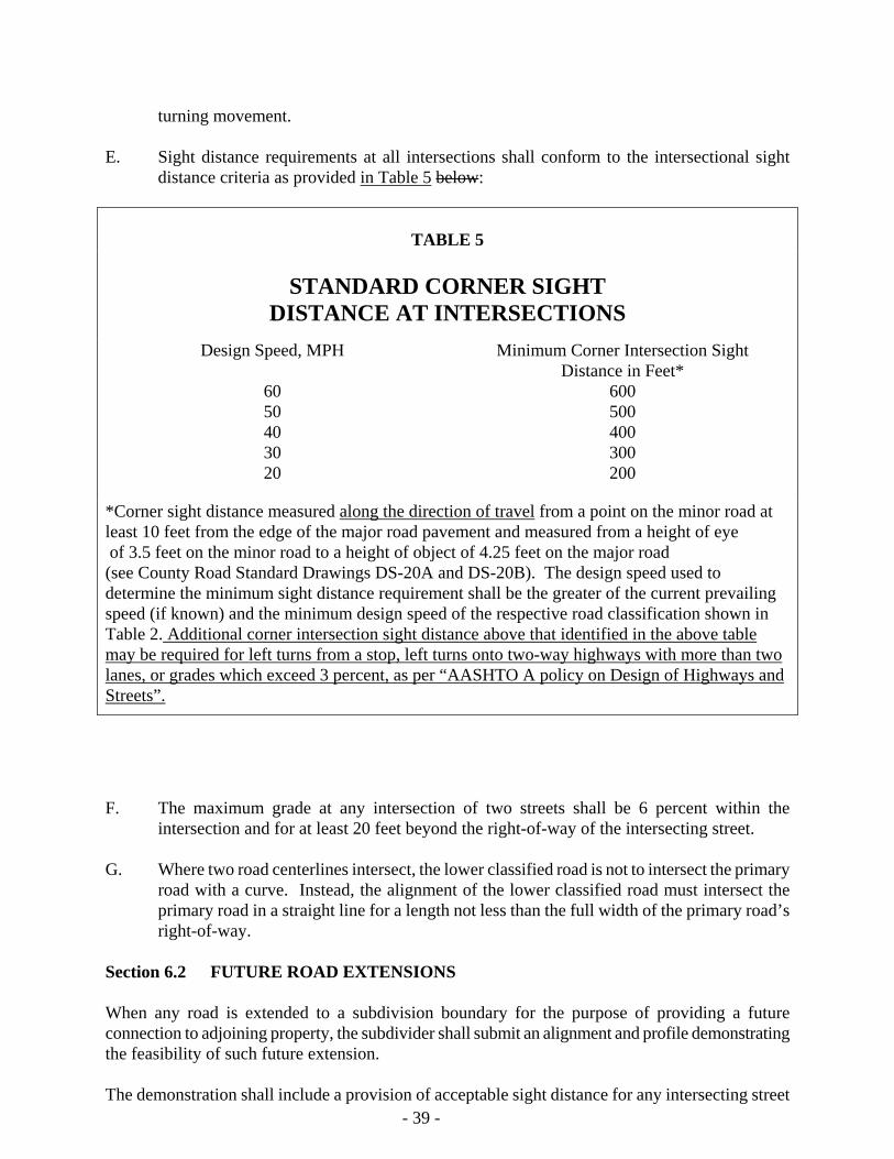
- 39 -
turning movement. E. Sight distance requirements at all intersections shall conform to the intersectional sight
distance criteria as provided in Table 5 below:
TABLE 5
STANDARD CORNER SIGHT
DISTANCE AT INTERSECTIONS Design Speed, MPH
60 50 40 30 20
Minimum Corner Intersection Sight Distance in Feet*
600 500 400 300 200
*Corner sight distance measured along the direction of travel from a point on the minor road at least 10 feet from the edge of the major road pavement and measured from a height of eye of 3.5 feet on the minor road to a height of object of 4.25 feet on the major road (see County Road Standard Drawings DS-20A and DS-20B). The design speed used to determine the minimum sight distance requirement shall be the greater of the current prevailing speed (if known) and the minimum design speed of the respective road classification shown in Table 2. Additional corner intersection sight distance above that identified in the above table may be required for left turns from a stop, left turns onto two-way highways with more than two lanes, or grades which exceed 3 percent, as per “AASHTO A policy on Design of Highways and Streets”.
F. The maximum grade at any intersection of two streets shall be 6 percent within the
intersection and for at least 20 feet beyond the right-of-way of the intersecting street. G. Where two road centerlines intersect, the lower classified road is not to intersect the primary
road with a curve. Instead, the alignment of the lower classified road must intersect the primary road in a straight line for a length not less than the full width of the primary road’s right-of-way.
Section 6.2 FUTURE ROAD EXTENSIONS When any road is extended to a subdivision boundary for the purpose of providing a future connection to adjoining property, the subdivider shall submit an alignment and profile demonstrating the feasibility of such future extension. The demonstration shall include a provision of acceptable sight distance for any intersecting street
- 40 -
shown on the plan which is within the design sight distance of the subdivision boundary. Such demonstration shall also extend for a distance of ¼ mile from the subdivision boundary or longer if specific circumstances so dictate. Section 6.3 GRADING A. Roads shall be graded by the developer to full width of right-of-way with the following
exceptions:
1. For Rural Collectors and Rural Mountain Roads, full grading may be required depending on expected ultimate traffic and/or special findings.
2. Grading for Recreational Parkways shall be minimized wherever possible. A11
embankments shall be contour graded to blend into the natural terrain and cut slopes are to be rounded. Graded slopes shall be as flat as possible and shall be planted in accordance with the surrounding natural flora.
3. The Director shall have the authority to modify full width grading requirements in areas
where such modification would not compromise driver, cyclist, or pedestrian or equestrian safety or in any way be detrimental to the public. In any such case, slope rights for future grading and drainage facilities shall be dedicated.
This requirement shall apply to all Circulation Element roads and to all other roads
where the County has a legal interest (fee, road easement, rejected offer of dedication, irrevocable offer of dedication) or where improvement plans are required as a condition of approval of acceptance of the project.
B. Grading or excavating in an existing County road right-of-way shall not be permitted unless
authorized by a valid permit. C. Where required improvements extend beyond the public right-of-way and onto private land,
the entity to provide such improvements shall acquire legal permission to trespass and construct the improvements. Permission is identified as a letter signed by the owner of the private land or other documents acceptable to the Department of Public Works.
Section 6.4 PAVEMENT AND STRUCTURAL SECTION A. Road Surface. The structural section shall be in accordance with San Diego County
Standards and as approved by the County Materials Laboratory. B. Design Criteria. Structural section design shall be based upon the highest Traffic Index (T.I.)
expected to occur during a period of 20 years following construction; except that minimum
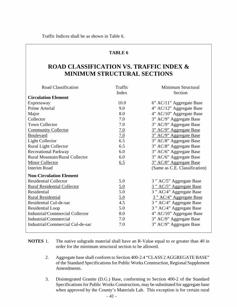
- 41 -
Traffic Indices shall be as shown in Table 6.
TABLE 6
ROAD CLASSIFICATION VS. TRAFFIC INDEX & MINIMUM STRUCTURAL SECTIONS
Road Classification
Traffic Index
Minimum Structural
Section Circulation Element Expressway Prime Arterial Major Collector Town Collector Community Collector Boulevard Light Collector Rural Light Collector Recreational Parkway Rural Mountain/Rural Collector Minor Collector Interim Road
10.0 9.0 8.0 7.0 7.0 7.0 7.0 6.5 6.5 6.0 6.0 6.5
6” AC/11” Aggregate Base 4” AC/12” Aggregate Base 4” AC/10” Aggregate Base 3” AC/9” Aggregate Base 3” AC/9” Aggregate Base 3” AC/9” Aggregate Base 3” AC/9” Aggregate Base 3” AC/8” Aggregate Base 3” AC/8” Aggregate Base 3” AC/6” Aggregate Base 3” AC/6” Aggregate Base 3” AC/8” Aggregate Base (Same as C.E. Classification)
Non-Circulation Element Residential Collector Rural Residential Collector Residential Rural Residential Residential Cul-de-sac Residential Loop Industrial/Commercial Collector Industrial/Commercial Industrial/Commercial Cul-de-sac
5.0 5.0 5.0 5.0 4.5 5.0 8.0 7.0 7.0
3 ” AC/5” Aggregate Base 3 ” AC/5” Aggregate Base 3 ” AC/4” Aggregate Base 3 ” AC/4” Aggregate Base 3 ” AC/4” Aggregate Base 3 ” AC/4” Aggregate Base 4” AC/10” Aggregate Base 3” AC/9” Aggregate Base 3” AC/9” Aggregate Base
NOTES 1. The native subgrade material shall have an R-Value equal to or greater than 40 in
order for the minimum structural section to be allowed. 2. Aggregate base shall conform to Section 400-2.4 “CLASS 2 AGGREGATE BASE”
of the Standard Specifications for Public Works Construction, Regional Supplement Amendments.
3. Disintegrated Granite (D.G.) Base, conforming to Section 400-2 of the Standard
Specifications for Public Works Construction, may be substituted for aggregate base when approved by the County’s Materials Lab. This exception is for certain rural
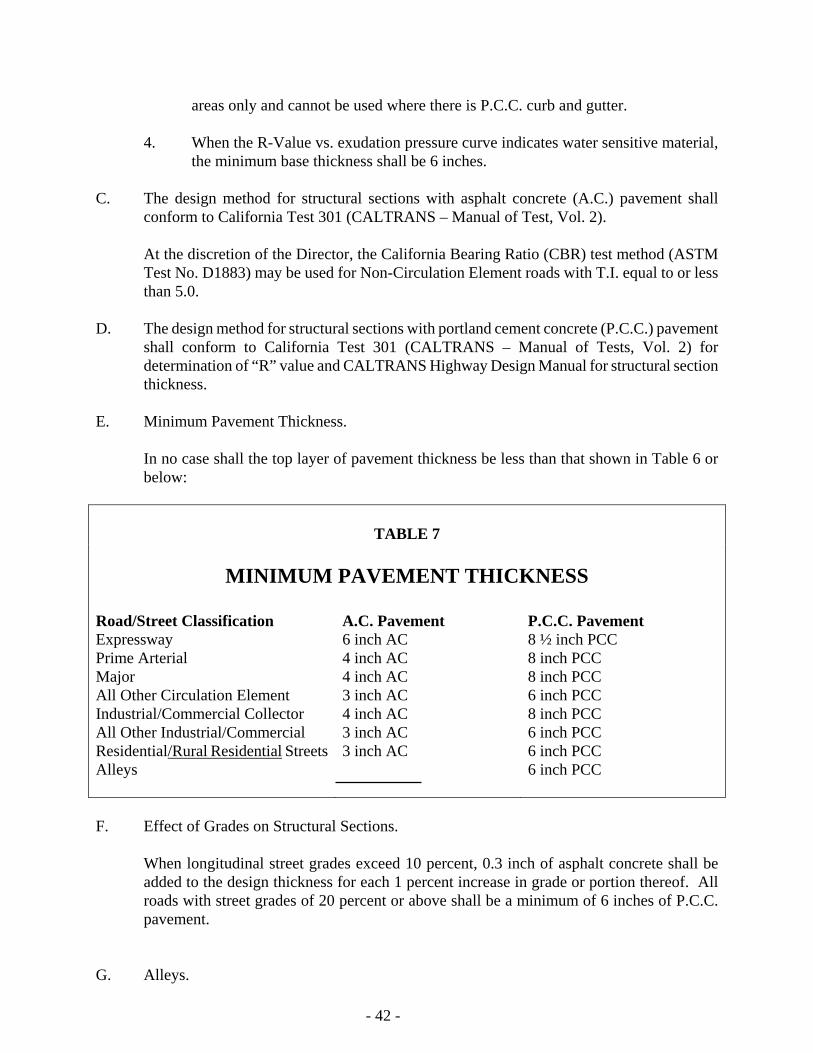
areas only and cannot be used where there is P.C.C. curb and gutter.
4. When the R-Value vs. exudation pressure curve indicates water sensitive material, the minimum base thickness shall be 6 inches.
C. The design method for structural sections with asphalt concrete (A.C.) pavement shall
conform to California Test 301 (CALTRANS – Manual of Test, Vol. 2).
At the discretion of the Director, the California Bearing Ratio (CBR) test method (ASTM Test No. D1883) may be used for Non-Circulation Element roads with T.I. equal to or less than 5.0.
D. The design method for structural sections with portland cement concrete (P.C.C.) pavement
shall conform to California Test 301 (CALTRANS – Manual of Tests, Vol. 2) for determination of “R” value and CALTRANS Highway Design Manual for structural section thickness.
E. Minimum Pavement Thickness.
In no case shall the top layer of pavement thickness be less than that shown in Table 6 or below:
TABLE 7
MINIMUM PAVEMENT THICKNESS
Road/Street Classification Expressway Prime Arterial Major All Other Circulation Element Industrial/Commercial Collector All Other Industrial/Commercial Residential/Rural Residential StreetsAlleys
A.C. Pavement 6 inch AC 4 inch AC 4 inch AC 3 inch AC 4 inch AC 3 inch AC 3 inch AC
P.C.C. Pavement 8 ½ inch PCC 8 inch PCC 8 inch PCC 6 inch PCC 8 inch PCC 6 inch PCC 6 inch PCC 6 inch PCC
F. Effect of Grades on Structural Sections.
When longitudinal street grades exceed 10 percent, 0.3 inch of asphalt concrete shall be added to the design thickness for each 1 percent increase in grade or portion thereof. All roads with street grades of 20 percent or above shall be a minimum of 6 inches of P.C.C. pavement.
G. Alleys. - 42 -
- 43 -
The developer shall use full width P.C.C. inverted section. H. Seal Coat.
All new asphalt concrete surfaces shall receive a seal coat consisting of a coat of asphalt emulsion and a sand cover. The type of materials and method of construction shall be as approved by the Director of Public Works.
I. Bikeways contiguous to the roadway shall have the same structural section as the roadway. J. Where irrigated landscaping is adjacent to the road, additional drainage, subdrainage and
erosion protective measures shall be required to prevent damage to the structural sections by removing surface water and seepage. When a concrete curb and gutter is not installed a subdrain at least 12 inches below subgrade shall be installed.
K. When proposed residential roads after completion of construction are to become temporary
haul roads for building material and equipment for existing or future development, the structural section thickness shall be increased based upon the expected traffic index generated by the proposed future construction.
Section 6.5 CROSS-FALL, CROWN, AND CROSS-SLOPE IN STREETS A. Maximum cross-fall, other than superelevation, shall not exceed 3 percent. B. An off-center crown shall not be permitted. C. Standard cross-slope shall be 2 percent; minimum cross-slope shall be 1 percent; maximum
cross-slope shall be 5 percent. For roads in elevations above 3,500 feet, the maximum cross-slope may be reduced to account for inclement weather conditions.
D. Cross-slope and grade shall not be minimum at the same location. The cross-slope shall be
no less than 2 percent where the street grade is no greater than 1 percent. E. In design of intersections and transition sections, cross-fall and cross -slope may deviate
from the above as necessary to meet the intersecting street. F. Where superelevation is necessary in a cut, provision for the retention of slope drainage shall
be accomplished to prevent cross-street flow. On the high side of the curve adjacent to the curb or berm, an adverse 10% cross-slope five feet wide shall be constructed.
Section 6.6 UTILITY PLACEMENT A. All utilities which are to be underground shall be constructed or installed prior to the
construction of any required improvements within the right-of-way including but not limited to, roads, curbing, sidewalks, pathways and driveways that may hinder or restrict the proper installation of said utility, except as may be otherwise approved by the Director.
B. The minimum cover of any underground utility within the pavement section shall be 30
- 44 -
inches, except that non-hazardous systems installed outside the traveled way may be at a lesser depth upon approval by the Director. Concrete encasement shall be required of water and sewer pipes with less than 3 feet of cover.
C. Underground utilities are to be installed in accordance with County specifications. D. In areas that include pathways, above ground utilities, including equipment, structures and
signs, shall be placed a minimum of 5 feet from back of the road curb or berm or on the opposite side of the street from the pathway. Additional right-of-way may be required to provide a clear, unobstructed 10-foot wide pathway.
E. Where pathways are included within a parkway width of 15 feet or greater, the outermost 5
feet shall remain unobstructed. Above ground utilities, including accessory equipment, structures, and signs shall be placed no more than 10 feet from the back of the road curb or berm.
Section 6.7 DRIVEWAYS A. All driveway construction and location shall be in conformance with San Diego Area
Regional Standard Drawings and San Diego County Design Standards. B. All construction to connect driveways to County roads, shall be first authorized by a valid
permit. C. Arrangements for the necessary removal or relocation of any public utilities, structures, trees
or plantings shall be made by the developer or permittee prior to commencing any work. Such removal or relocation shall be accomplished at no expense to the County.
D. For the purpose of these standards, a residential driveway is any driveway to any property
used solely as a private residence or a double-family dwelling unit, including farms or ranches not used as retail outlets. All other driveways shall be termed commercial driveways.
E. When an opening for a driveway, or any other purpose, is to be constructed through an
existing P.C.C. curb, the existing curb, or curb and gutter, shall be saw-cut at the limits of work or removed to the nearest construction joints and the opening replaced with standard curb and driveway.
F. When a driveway through a P.C.C. curb is abandoned, or is replaced by another driveway
serving the same property, the owner shall remove that portion of existing driveway opening which will not be used and construct full height curb across the superfluous opening and
shall fill the depression behind the curb to conform to surrounding improvements. G. If P.C.C. curb and gutter are existing driveway apron shall also be constructed with P.C.C. H. Stamp crete or other glazed materials are not permitted on driveways within the public right-
of-way.
- 45 -
I. Driveway Location
1. When the interior property line angle of an intersection between two streets is less than 70 degrees, no driveway curb opening encroachment into the curb radius shall be made.
2. No driveway curb opening shall be permitted within a curb return.
3. Curb returns on driveways will be allowed only where needed for on or off-site drainage.
4. The nearest edge of any driveway or curb opening shall be at least 3 feet from a fire
hydrant, utility pole, or traffic signal installation or safety lighting standard. 5. Along County maintained roads, driveway separation from other driveways and roads
shall conform to Section 6.1.C.1 and Section 6.1.C.2. The proposed driveway will be considered a non-Circulation Element road. If conformance with Section 6.1.C.1 and Section 6.1.C.2 can not be achieved because of factors such as limited property frontage, topography, or available sight distance, then a modification of this standard may be granted provided the proposed driveway is located at the location which would cause the least traffic impact.
J. Driveway Grading - Driveway grades shall conform to the cross-slope within the traveled
way and parking lanes of the ultimate section of the road. Outside this area, but within the right-of-way, driveway grades shall conform to sidewalk grades, if sidewalks or pathways are provided. In no event shall driveway grades exceed 10 percent within the right-of-way.
K. On paved roads where P.C.C. curbs are not installed, driveway approaches shall be
constructed of asphalt concrete or road oil mix and shall extend from the edge of the traveled way to the property line. Total driveway section thickness shall be equal to the structural section specified on the appropriate County Design Standard Drawing.
L. Portland cement concrete curb openings will be permitted only in those locations where
complete standard portland cement concrete driveways are to be constructed concurrently or are existing.
M. Driveway Culverts - Where driveways cross existing roadside ditches, a dip section
providing an unobstructed waterway equivalent to the full area of the ditch may be used. Where grades make the use of a dip section infeasible, a culvert pipe not less than 18 inches in diameter shall be installed. When a driveway culvert is to be used, the design shall be to the approval of the Director.
N. Angle of Departure - The angle of departure along the public road and the adjacent
driveway shall not exceed 7%. The angle of departure is the smallest angle made between the road surface and a line drawn from the front point of the ground contact of the front tire for a pumper fire apparatus (as per Standard NFPA 1901) to any projection of the apparatus in front of the front axle. The angle of approach affects the road clearance of the vehicle when going over short steep grades such as found in a driveway entrance or crossing a high crowned road at right angles. Too low an angle of approach will result in scraping the apparatus body.
- 46 -
Section 6.8 ROAD ALIGNMENTS A. Curves shall be separated by appropriate tangent sections as follows:
1. Tangent sections for Circulation Element roads shall be a minimum of 400 feet between curves.
2. Where superelevation is employed, tangent sections shall not be less than the
superelevation runoff length required between curves. B. Compound curves shall be prohibited.
- 47 -
SECTION 7 BIKEWAYS
Section 7.1 BIKEWAY DESIGN STANDARD The State of California, Department of Transportation publication, Chapter 1000 “Bikeway Planning and Design” of the California Highway Design Manual, Planning and Design Criteria for Bikeways in California, as amended, is the bikeway standard for San Diego County. Section 7.2 BIKEWAY DEFINITIONS The following definitions are taken from the above publication and are included in this document for convenience: A. BIKEWAY - is the generic term for all facilities that explicitly provides for bicycle travel. B. CLASS I BIKEWAY - (Bike Path or Bike Trail) provides a completely separated right-of-
way designated for the exclusive use of bicycles and pedestrians, with cross-flows by motorists minimized.
C. CLASS II BIKEWAY - (Bike Lane) provides a restricted right-of-way designated for the
semi-exclusive use of bicycles with through travel by motor vehicles or pedestrians prohibited, but with vehicle parking and cross-flows by pedestrians and motorists permitted.
D. CLASS III BIKEWAY - (Bike Route) provides a right-of-way designated by signs or
permanent markings and shared with pedestrians or motorists. Section 7.3 BIKEWAY REQUIREMENTS The developer shall offer to dedicate and construct, in accordance with San Diego County Standards, all bikeways shown on the San Diego County General Plan which pass through or abut the development. The structural section shall be the same as the contiguous roadway. Through traffic lanes adjacent to bike lanes on roads with high volume and/or high speed traffic (Collector Roads and above or as determined by the Director of Public Works) shall be 13 feet in width. Should the Director not require the construction of a bikeway as a condition of the development permit, the developer shall execute a covenant not to oppose a parking prohibition for the County's future implementation of a bike facility.
- 48 -
SECTION 8
PATHWAYS Section 8.1 PATHWAY DESIGN STANDARDS Board Policy (I-116), Policy Establishing Criteria for the Development and Operation of a Regional and Community Plan Non-Motorized Trails and Pathways System, The County Trails Master Plan includes goals for implementation of a pathways system. The County of San Diego, Department of Public Works publication, Regional Standard Drawings, Drawing Number G-7 (modified so that P.C.C. is replaced with D.G.) is the pathway standard for San Diego County. Section 8.2 PATHWAY DEFINITIONS The following definitions are included in this document for convenience: A. Pathway – is the generic term for soft-surfaced non-motorized transportation facilities
located within a parkway. B. Parkway – is the distance measured from the curb face, or edge of pavement where a curb is
nor provided, to the property line of a road right-of-way. Section 8.3 PATHWAY REQUIREMENTS When provided, pathways shall be improved, in accordance with section 5.3 of these standards and shall be consistent with the provisions of Board Policy I-116 and Chapter 3 of the Recreation Element of the County’s General Plan, which may also apply. The Community Trails Master Plan Design and Construction Guidelines. As outlined in section 9 of these standards, the Director may authorize necessary modifications to the improvements specified in Section 5.3, where existing road conditions, utility placement and other similar factors and where strict adherence to section 5.3 would make construction of the pathway infeasible.
- 49 -
SECTION 9
MODIFICATIONS Section 9.1 MODIFICATION PROCESSING PROCEDURES In recognition that strict adherence to these standards in every situation might result in impractical applications and unreasonable hardships, the following procedure is provided to properly respond to unique situations. A project proponent may request an modification by completing a “Request for an Modification to a Road Standard” form which details the location of the requested modification, alternatives considered, hardship of compliance with standard, and cost estimates. In some instances, it may be necessary for the applicant to provide an engineer’s sketch to properly describe the requested modification. In addition to engineering and regulatory concerns, the following factors may be considered: consistency with existing road characteristics in the project vicinity, likelihood of future public or private upgrades to the affected roads, access points to and from individual properties, established front-yard setbacks, potential environmental impacts, utility relocations, project and plan submittals made prior to the adoption of these standards, and established community character guidelines in the area. All requests for modifications involving road widths, grades, angle of departure and/or vertical clearance will require a letter from the Fire Authority having jurisdiction that approves such change, unless the Director determines that the Fire District requirements are excessive. County staff will assess the appropriateness of the requested modification. The Director will then review County staff’s assessment and make the final decision regarding the modification request. Prior to making his final decision, the Director may also obtain input from community planning and/or sponsor groups, the general public and/or other agencies. The Director’s final decision will be in the form of a letter to the applicant and project engineer explaining the decision and the justifications used in making that decision. A copy of the Director’s final decision, along with the completed application will be forwarded to the DPW Project Manager, the project inspector, the local fire authority and the project file. Modification requests associated with a discretionary permit application will be processed with that application. In cases where strict adherence to these standards will be extremely difficult to achieve, staff will prepare the draft conditions of approval so as to include a modification. In these cases, the specific modification will be identified in the draft conditions. Absence of any such specific modification in the conditions will mean that, unless a modification is later granted, the San Diego County Public Road Standards apply to all affected public roads. Modification requests which are not associated with a discretionary permit application will be processed separately according to applicable County guidelines. For instance, a modification request associated with a change to a condition of approval of a tentative map may require a resolution amendment or a map modification. A separate public hearing may then be required in order to process the modification request.
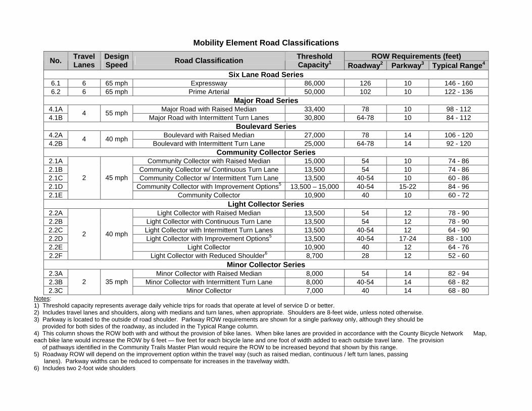
Mobility Element Road Classifications ROW Requirements (feet) No. Travel
Lanes Design Speed Road Classification Threshold
Capacity1 Roadway2 Parkway3 Typical Range4
Six Lane Road Series 6.1 6 65 mph Expressway 86,000 126 10 146 - 160 6.2 6 65 mph Prime Arterial 50,000 102 10 122 - 136
Major Road Series 4.1A Major Road with Raised Median 33,400 78 10 98 - 112 4.1B
4 55 mph Major Road with Intermittent Turn Lanes 30,800 64-78 10 84 - 112
Boulevard Series 4.2A Boulevard with Raised Median 27,000 78 14 106 - 120 4.2B
4 40 mph Boulevard with Intermittent Turn Lane 25,000 64-78 14 92 - 120
Community Collector Series 2.1A Community Collector with Raised Median 15,000 54 10 74 - 86 2.1B Community Collector w/ Continuous Turn Lane 13,500 54 10 74 - 86 2.1C Community Collector w/ Intermittent Turn Lane 13,500 40-54 10 60 - 86 2.1D Community Collector with Improvement Options5 13,500 – 15,000 40-54 15-22 84 - 96 2.1E
2 45 mph
Community Collector 10,900 40 10 60 - 72 Light Collector Series
2.2A Light Collector with Raised Median 13,500 54 12 78 - 90 2.2B Light Collector with Continuous Turn Lane 13,500 54 12 78 - 90 2.2C Light Collector with Intermittent Turn Lanes 13,500 40-54 12 64 - 90 2.2D Light Collector with Improvement Options5 13,500 40-54 17-24 88 - 100 2.2E Light Collector 10,900 40 12 64 - 76 2.2F
2 40 mph
Light Collector with Reduced Shoulder6 8,700 28 12 52 - 60 Minor Collector Series
2.3A Minor Collector with Raised Median 8,000 54 14 82 - 94 2.3B Minor Collector with Intermittent Turn Lane 8,000 40-54 14 68 - 82 2.3C
2 35 mph Minor Collector 7,000 40 14 68 - 80
Notes: 1) Threshold capacity represents average daily vehicle trips for roads that operate at level of service D or better. 2) Includes travel lanes and shoulders, along with medians and turn lanes, when appropriate. Shoulders are 8-feet wide, unless noted otherwise. 3) Parkway is located to the outside of road shoulder. Parkway ROW requirements are shown for a single parkway only, although they should be provided for both sides of the roadway, as included in the Typical Range column. 4) This column shows the ROW both with and without the provision of bike lanes. When bike lanes are provided in accordance with the County Bicycle Network Map, each bike lane would increase the ROW by 6 feet — five feet for each bicycle lane and one foot of width added to each outside travel lane. The provision of pathways identified in the Community Trails Master Plan would require the ROW to be increased beyond that shown by this range. 5) Roadway ROW will depend on the improvement option within the travel way (such as raised median, continuous / left turn lanes, passing lanes). Parkway widths can be reduced to compensate for increases in the travelway width. 6) Includes two 2-foot wide shoulders
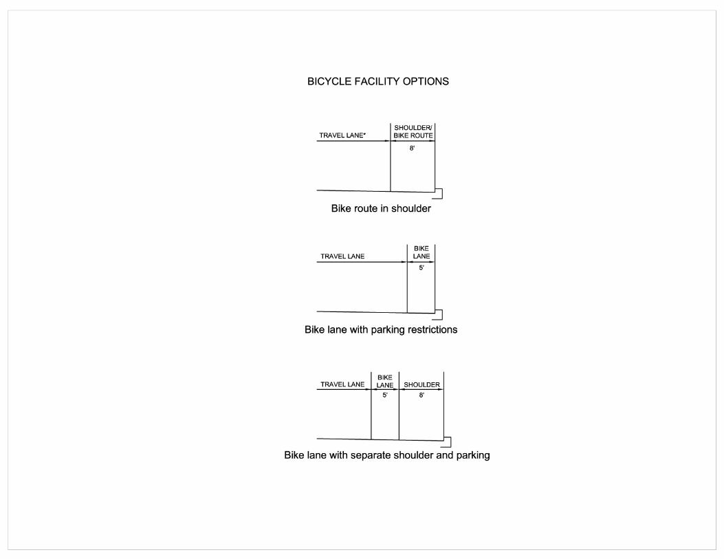
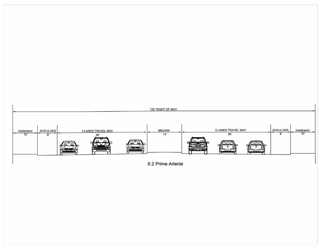
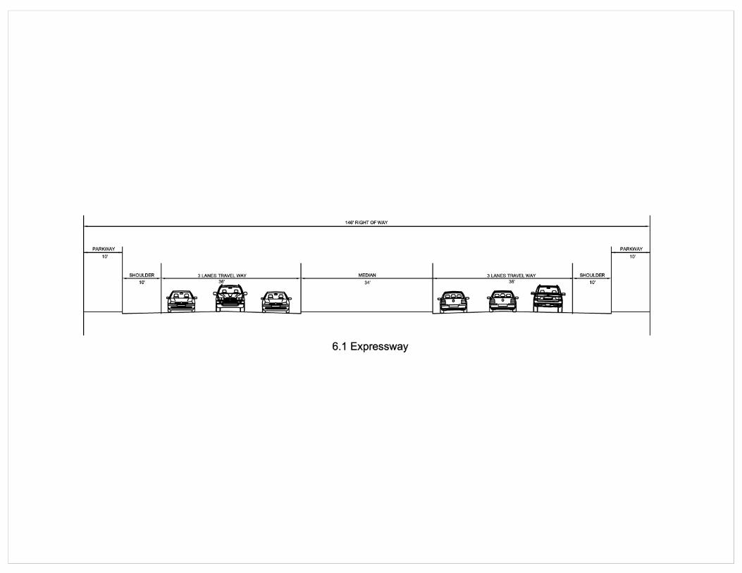
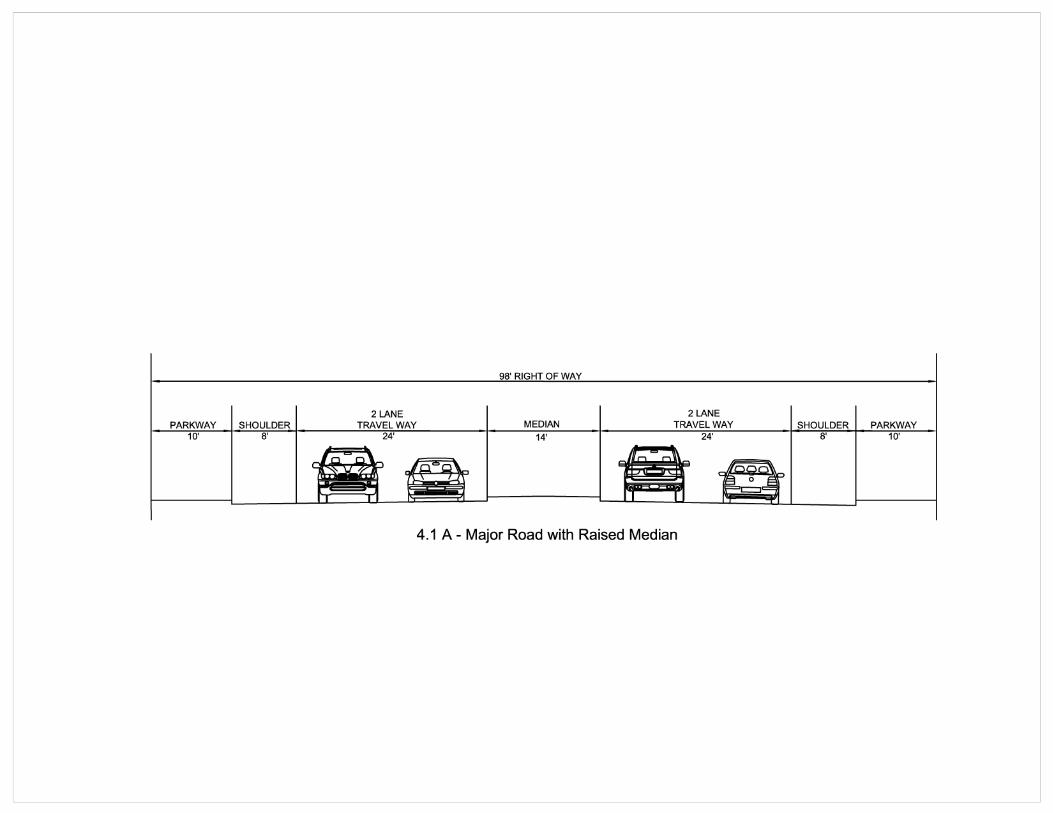
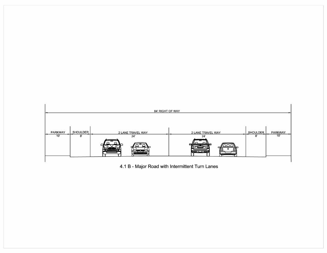
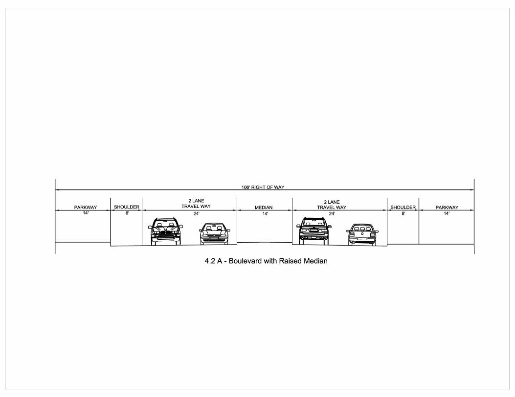
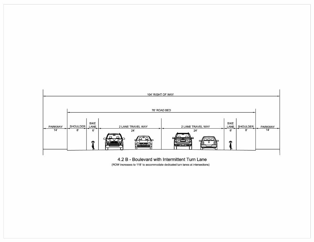
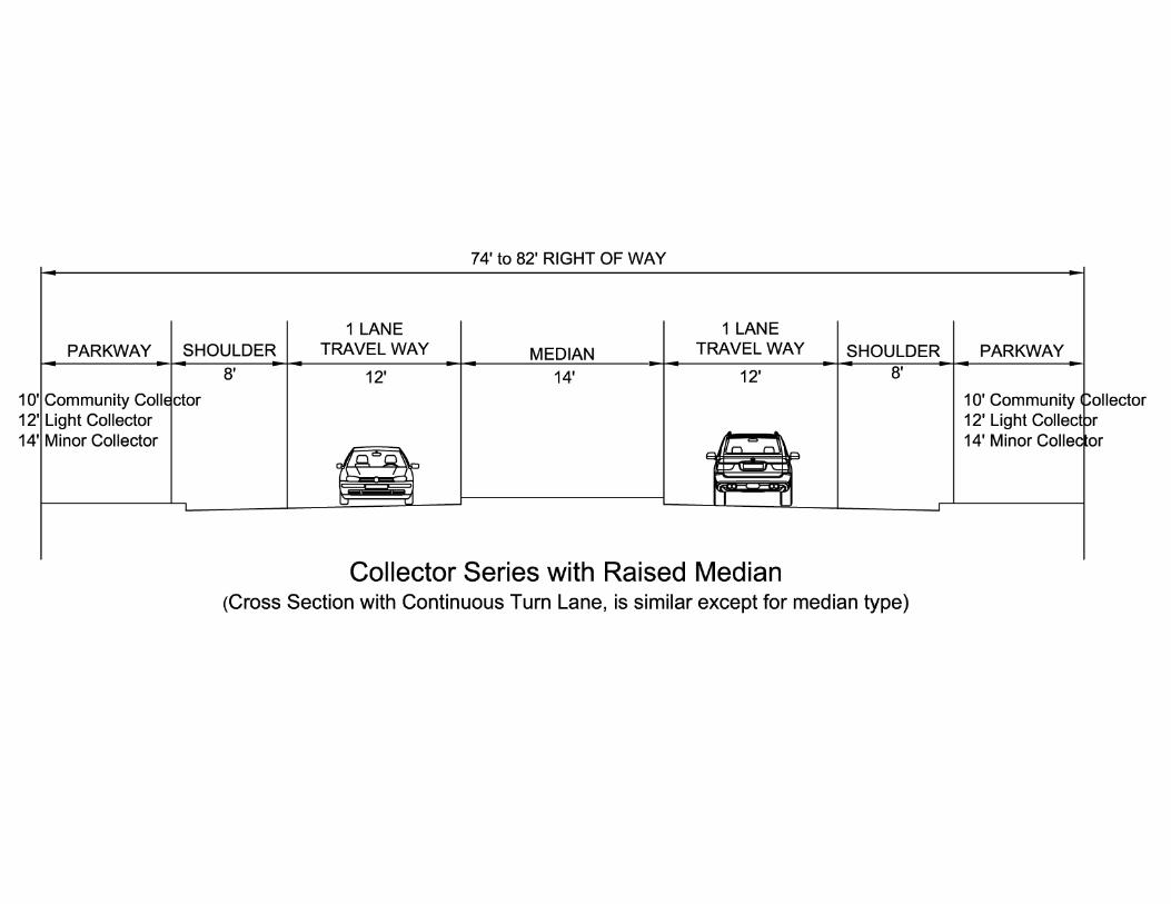
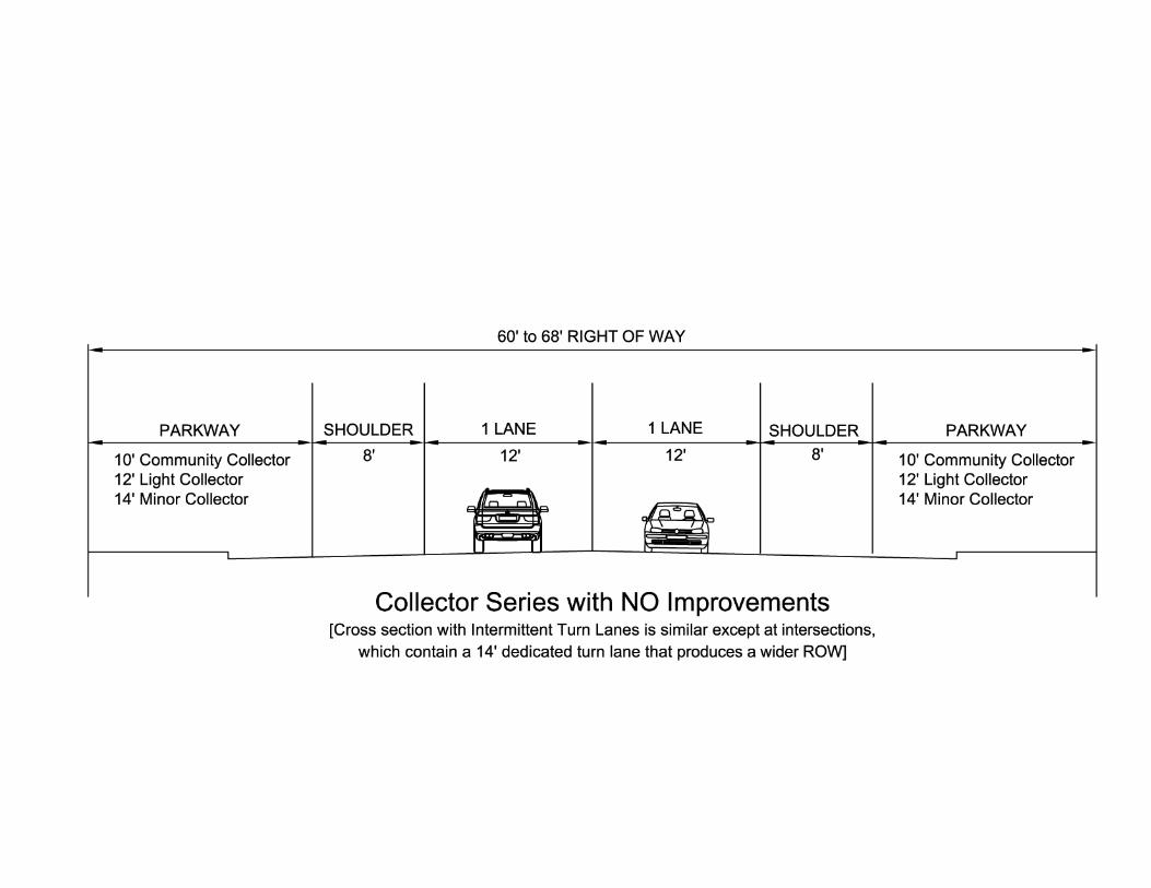
- 51 -
PUBLIC ROAD STANDARDS INDEX COUNTY OF SAN DIEGO
ACCESS (Circulation Element Rds) .............................................................................................10 ADDITIONAL TURN LANES.....................................................................................................13 ALIGNMENTS, Road ...................................................................................................................41 ALLEYS, Design...........................................................................................................................18 ALLEYS, Paving ......................................................................................................................20,37 ALLOWABLE ROAD FLOODING LIMITS...............................................................................30 ANGLES, Intersecting Road .........................................................................................................33 AS-BUILT PLANS (Record Plans).................................................................................................7 AVERAGE DAILY TRIPS .............................................................................................................9 BASE, Structural Section .........................................................................................................36,37 BIKEWAYS ..................................................................................................................................42 BOUNDARY ROAD (Half-width Rd)..........................................................................................18 BRIDGES ......................................................................................................................................32 CALCULATIONS.........................................................................................................................30 CENTERLINE SEPARATION .....................................................................................................34 CIRCULATION ELEMENT ROADS .......................................................................................8,10 CLASSIFICATIONS, Road ............................................................................................................8 COLLECTORS, Industrial/Commercial........................................................................................16 COLLECTORS, Residential..........................................................................................................15 COMMERCIAL CURB RETURNS .............................................................................................33 CROSS GUTTERS........................................................................................................................31 CROSS-ROAD DRAINAGE ........................................................................................................31 CROSS-SECTIONS, Road ..............................................................................................................8 CROSS-SLOPE .............................................................................................................................38 CROSS-FALL................................................................................................................................38 CROWN.........................................................................................................................................38 CUL-DE-SAC, Commercial ..........................................................................................................17 CUL-DE-SAC, Residential............................................................................................................16 CUL-DE-SAC, Turn around grade ................................................................................................12 CULVERTS, Driveway .................................................................................................................40 CURB RETURNS, Commercial....................................................................................................33 CURB RETURNS, Radius: ...........................................................................................................33 CURBS ..........................................................................................................................................23 CURVE RADIUS, Minimum (Table 2) ........................................................................................11 DEFINITIONS, General ..................................................................................................................2 DESIGN RUNOFF ........................................................................................................................29 DESIGN STANDARDS................................................................................................................33 DIKES............................................................................................................................................23 DIP SECTIONS.............................................................................................................................31 DIVERTED RUNOFF...................................................................................................................30 DOCUMENTS (References) ...........................................................................................................4 DRAINAGE IMPROVEMENTS ..................................................................................................29 DRAINAGE SYSTEM..................................................................................................................29 DRIVEWAY LOCATION ............................................................................................................40
- 52 -
DRIVEWAYS...........................................................................................................................24,39 ENERGY DISSIPATERS .............................................................................................................32 EXCEPTIONS .................................................................................................................................1 FENCING (Channels)....................................................................................................................31 FLOOD-FREE SITES ...................................................................................................................30 FLOODING LIMITS, Road ..........................................................................................................30 FLOODWAY.................................................................................................................................30 FLOWAGE EASEMENTS............................................................................................................31 FREEBOARD (Bridges)................................................................................................................32 FRONTAGE ROADS....................................................................................................................18 FUTURE ROAD EXTENSIONS ..................................................................................................34 GENERAL NOTES .........................................................................................................................8 GENERAL POLICY .......................................................................................................................6 GRADING .....................................................................................................................................35 GUARDRAIL ................................................................................................................................25 GUTTER, Cross.............................................................................................................................31 HALF-WIDTH ROADS................................................................................................................17 HANDICAPPED RAMPS.............................................................................................................23 HIGHWAY GUARDRAIL............................................................................................................25 HILLSIDE RESIDENTIAL STREET...........................................................................................20 HYDRAULIC PROCEDURES .....................................................................................................30 ILLUMINATION ..........................................................................................................................27 IMPROVEMENTS........................................................................................................................25 IMPROVEMENT PLANS...............................................................................................................7 INDUSTRIAL/COMMERCIAL COLLECTOR...........................................................................16 INDUSTRIAL/COMMERCIAL CUL-DE-SAC...........................................................................17 INDUSTRIAL/COMMERCIAL LOOP ROAD............................................................................17 INDUSTRIAL/COMMERCIAL ROADS.....................................................................................17 INTERIM ROADS ...................................................................................................................15,19 INTERSECTING ROAD ANGLES..............................................................................................33 INTERSECTION, Design: .......................................................................................................15,33 INTERSECTION, Improvements.............................................................................................15,33 INTERSECTION (Sight Distance)...........................................................................................12,34 INTERSTATE TRUCK ROUTES ................................................................................................33 INTRODUCTION ...........................................................................................................................1 LANE WIDTH...............................................................................................................................10 LEFT TURN LANES ....................................................................................................................13 LEVEL OF SERVICE (Table 1) .....................................................................................................9 LIGHTING, Street .........................................................................................................................26 LIGHTING, Street, Waivers..........................................................................................................27 LOOP ROADS...............................................................................................................................17 MEDIANS .....................................................................................................................................28 MEDIAN OPENINGS...................................................................................................................28 MINIMUM STANDARDS (Table 2)............................................................................................11 NON-CIRCULATION ELEMENT ROADS .............................................................................8,15 OFF-SITE IMPROVEMENTS........................................................................................................7 PARKWAYS, Recreational ...........................................................................................................14 PATHWAYS .........................................................................................................................3,23,43
- 53 -
PAVEMENT THICKNESS...........................................................................................................37 PAYMENTS....................................................................................................................................6 PLAN APPROVAL .........................................................................................................................6 PLAN CHANGES ...........................................................................................................................6 POLICY, General ............................................................................................................................6 PUBLIC ROAD IMPROVEMENTS .........................................................................................8,23 PURPOSE OF STANDARDS.........................................................................................................1 RADIUS, Curb Return...................................................................................................................33 RADIUS, Curve, Minimum (Table 2) ...........................................................................................11 RAMPS, Handicapped...................................................................................................................23 RECORD PLANS (As-built) ...........................................................................................................7 RECREATIONAL PARKWAY....................................................................................................14 REFERENCES (Other documents) .................................................................................................4 RELOCATION OF EXIST. FACILITIES ......................................................................................7 REMOVAL OF EXISTING FACILITIES......................................................................................7 REQUIRED IMPROVEMENTS................................................................................................9,25 RESIDENTIAL COLLECTOR ROAD.........................................................................................15 RESIDENTIAL CUL-DE-SAC.....................................................................................................16 RESIDENTIAL LOOP ROAD......................................................................................................16 RESIDENTIAL ROAD .................................................................................................................15 RETENTION BASINS..................................................................................................................31 ROAD ALIGNMENTS .................................................................................................................41 ROAD CLASSIFICATIONS...........................................................................................................8 ROAD CROSS-SECTIONS .........................................................................................................8,9 ROAD FLOODING LIMITS ........................................................................................................30 ROAD (STREET) NAME SIGNS.................................................................................................25 ROADWAY LIGHTING...............................................................................................................26 ROUTES, Interstate Truck ............................................................................................................33 RUNOFF, DESIGN .......................................................................................................................29 RURAL COLLECTORS ...............................................................................................................14 RURAL MOUNTAIN ROADS.....................................................................................................14 SEAL COAT..................................................................................................................................38 SEDIMENTATION BASINS........................................................................................................31 SEPARATION OF INTERSECTIONS.........................................................................................33 SIDEWALKS ................................................................................................................................23 SIGHT DISTANCE, Intersection .............................................................................................12,34 SIGNALS, Traffic..........................................................................................................................25 SIGNS, Road Name .......................................................................................................................25 SPLIT-LEVEL ROAD...................................................................................................................19 STANDARDS, Minimum (Table 2)..............................................................................................11 STORM DRAIN SYSTEM ...........................................................................................................29 STREET LIGHTS.....................................................................................................................25,26 STREET NAME SIGNS................................................................................................................25 STRUCTURAL SECTIONS ....................................................................................................35,36 SUMP AREAS...............................................................................................................................31 SUPPLEMENTAL INFORMATION ...........................................................................................10 SURFACE DRAINAGE, Cross-road ............................................................................................30 SURVEY MONUMENTS.............................................................................................................28
- 54 -
TANGENT LENGTH (Between curves).......................................................................................40 THICKNESS, Pavement................................................................................................................37 TOWN COLLECTOR ...................................................................................................................14 TRAFFIC INDEX..........................................................................................................................36 TRAFFIC SIGNALS .....................................................................................................................25 TRAFFIC VOLUMES (Table 1) .....................................................................................................9 TRAVEL LANES (width) .............................................................................................................10 TRUCKS, Interstate Routes...........................................................................................................33 TURN LANES, Additional............................................................................................................15 TWO-WAY LEFT TURN LANES ...............................................................................................29 TYPE OF STORM DRAIN SYSTEM ..........................................................................................29 TYPICAL CROSS-SECTION.........................................................................................................8 UTILITY PLACEMENT...............................................................................................................38 VOLUMES, Traffic (Table 1) .........................................................................................................9 WAIVERS (Road Lighting) ..........................................................................................................27 WARNING SIGNS........................................................................................................................25 WHEELCHAIR RAMPS...............................................................................................................23 WIDENING EXISTING ROADS, On-site .....................................................................................7 WIDENING EXISTING ROADS, Off-site.....................................................................................7

- 49 -