Embed Size (px)
Citation preview
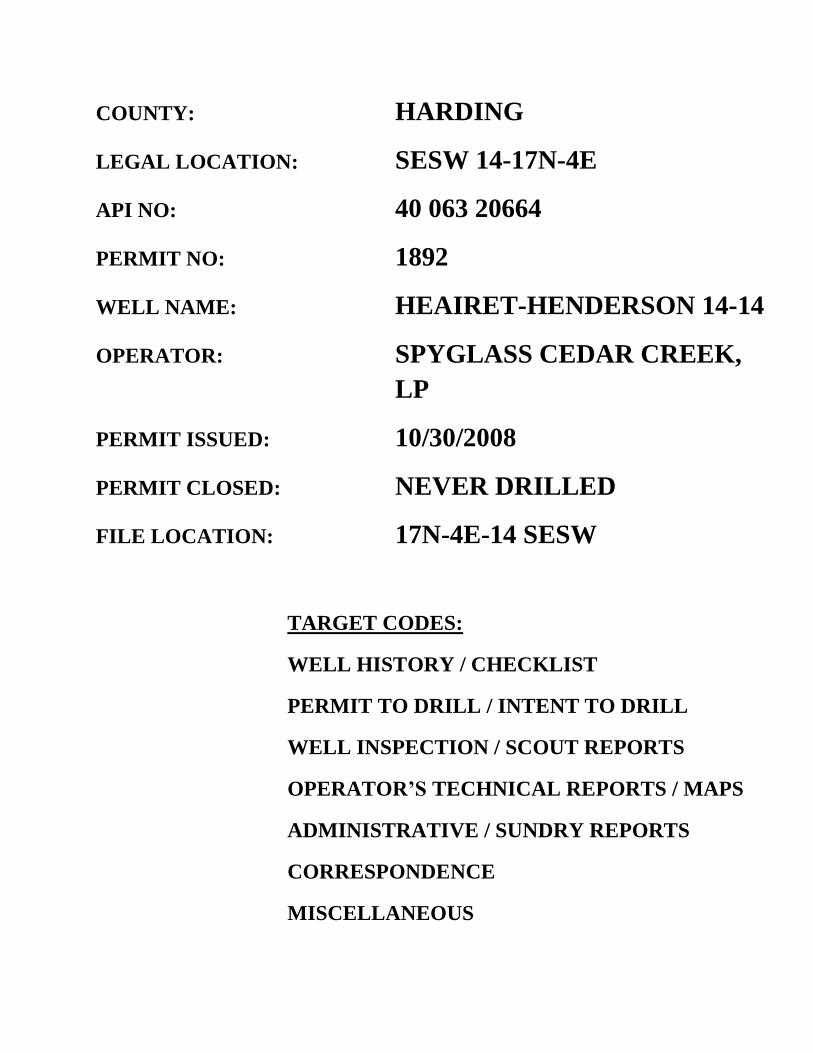
COUNTY: HARDING
LEGAL LOCATION: SESW 14-17N-4E
API NO: 40 063 20664
PERMIT NO: 1892
WELL NAME: HEAIRET-HENDERSON 14-14
OPERATOR: SPYGLASS CEDAR CREEK,
LP
PERMIT ISSUED: 10/30/2008
PERMIT CLOSED: NEVER DRILLED
FILE LOCATION: 17N-4E-14 SESW
TARGET CODES:
WELL HISTORY / CHECKLIST
PERMIT TO DRILL / INTENT TO DRILL
WELL INSPECTION / SCOUT REPORTS
OPERATOR’S TECHNICAL REPORTS / MAPS
ADMINISTRATIVE / SUNDRY REPORTS
CORRESPONDENCE
MISCELLANEOUS

WELL HISTORY / CHECKLIST

REVIEW OF PERMIT APPLICATIOyr Surface casing program: i-4hrough Fox Hillsequate as stated Spacing regyjrAments: 14!
SHL4-4fleVistatewide spacing agexception granted (Case # conforms to 5-- z4o4 Field spacing
il\rt\---(13HL: conforms to Order conforms to Field spacing
t'ERMIT and BOND RELEASE CHECKLI3
WELL NAME: Spyglass: 14-14 Heairet-Henderson LOCATION: T17N-R4E-14 SESW, Harding County
PERMIT NO: / c.1
FORMS RECEIVED /Application (Form 2) vrermit Fee of $100.00
fOil & Gas Leasing Agreement ✓ ermission to Inspect Form
& P Bond
API NO: "g0 :,-04761
_Plat Map ...Organization Report (Form 1) if not on file 1-.Certificate of Negotiation (Form 9)
,certification of Applicant V Surface Restore Bond
NOTIFICATION OF PENDING APPLICATION /State Archaeologist SD Dept. of Game, Fish Parks LA-Larding County Zoning Adm.
Fax 605-375-3318
REVIEW OF PIT LINER VARIANCE plans and specifications sent to staff engineer
Ipproved Disapproved _Variance granted _Variance denied 12 mil liner to be used as required by ARSD 74:10:03:13
PERMIT 4PPROVED
3T
ransmit check to Treasurer's Office with copy to our accounting personnel /Type Permit #, API # and date on Application for Permit, have supervisor sign two forms.
repare conditions to permit (O:\O&G\Reports\Apd\Conditions\ .doc) ail cover notice (O:\O&G\Reports\Misc Letters & Notices\OperPermitNote.doc), operator
z application, conditions, fee receipt, and pit liner application - if applicable 'Fax application copies to Harding Co. 605-375-3318 arrd the Anderson Reports ZAdd to New Permits List (010&G/New Permits/NewPermit.doc) ./Add to API and Permit No. Lists (010&G/Permits/API & Permit No.s/)
;dd to Bond Lists (O:\O&G\Reports\Bonds\Bondbalance.xls & BondList.doc) VAdd to database and Web site
Prepare file folder following established labeling and order of material. File.
PLUGGING AND PERFORMANCE BOND RELEASE _Well Logs _Geologist's Report _DST Chart and Reports _Results of coring and core analyses
_Set of 10-foot sample cuttings-Vermillion Completion/Recompletion Report
_Plugging Report
SURFACE RESTORATION BOND RELEASE Approved Scout Report _Approved letter from Surface Owner
BOND RELEASE NOTIFICATION Letter to bond carrier to release liability with copy to operator (O:\O&G\Reports\Bonds
\BondRelease.doc) _Enter information in Bond Lists (O:\O&G\Reports\Bonds\BondList.doc and Bondbalance.xls) and
database.

IIIII41 al, INIIINI / IIIIICI of IHAIllad

•■• VI I AI la -r•-.0 I
API No. 40 063 20664 Permit No. 1892 Conditions, if any. on attached page.
Date Issued: October 30, 2008
'4RTMENT of ENVIRONMENT and NATURAL RES' 'CES FORM 2 Mine. & Mining Program - Oil & Gas Section
2050 West Main, Suite #1, Rapid City, SD 57702-2493 RECEIVED Tel ne: 605-394-2229, FAX: 605-394-5317
OCT 1 4 2008
DEPT OF ENVIRONMENT& NATURAL
ATION FOR PERMIT TOVR1URAP►ocIry
GREAT ACES. ER FAIPLA
Ake044:toy se of wo• ON i It , ell r"- ente. ,‘,,.,
AN- 0 P v
Ty i of well: Drill Directional Well Oil Well
Other
y. Gas W ell Injection
# me and • -ss of Operator: Telephone
S Cedar Creek, LP. 595 S. Castell Ave., New Braunfels, Texas 78130 (830) 626-7100
Name and Address of Surface Owner:
Mike & Vicky Heairet P.O. Box 141 Buffalo, SD 57720
Name and Address of Drilling Contractor and Rig Number: Elenburg Exploration Rig 8 1910 N. Loop, Casper, WY 82602
Surface Location of well: Qtr-Qtr, Sec, Twp, Rge, County, feet from nearest lines of section, and latitude and longitude (if available):
SESW Sec 14 T17NR4E, Harding Cnty 990'FSL 1700'FWL Lat=45deg25'56.51"N Lon=103deg36'01.48"W
If Directional, top of pay and bottom hole location from nearest lines of section:
Acres in Spacing (Drilling) Unit Description of Spacing Unit
320 S/2 Sec 14 T17N R4E
Well Name and Number
Heairet-Henderson 14-14
Elevation
3169.7'
Field and Pool, or Wildcat
Wildcat
Proposed Depth and Formation
2200 Eagle/Shannon
Size of Hole 1) 9 7/8 2) 6 1/4 3) 4)
Size of Casing 7 4 1/2
Weight per Foot 17 10.5
Depth 400 2200
Cementing Program (amount, type, additives) Depth 200 sks, Class g 2% CaC12 surf .25#SK Celloflake, 100% excess 2200 105 SKS, Lite 1500, 2%CaCI. .25 to 125 sks G1% CaCi, 7%CFL, .25#/sk surf
Describe Proposed Operations (Clearly State all Pertinent Details, and Give Pertinent Dates, Including Estimated Date of Starting any Proposed Work). Use additional page(s) if appropriate.
Drill with fresh water mud to 2200'. 12 mil pit liner in place. Anticipated Spud Date October 15 2008.
I hereby c- ify that the foregoing as to any work or operation performed is a true and correct report of such work or operation.
Kevin Sellers Partner 10/10/2008 , Signatur Name (Print) Title Date
FOR OFFICE USE ONLY
Approve Title:

DEPARTMENT of ENVIRONMENT and NATURAL RESOURCES
Minerals & Mining Program Oil & Gas Office
2050 West Main Street, Suite #1 Rapid City, SD 57702-2493
Telephone: 605-394-2229 Fax: 605-394-5317
GREAT [REES. GU PLACES.
PERMIT CONDITIONS
Spyglass 14-14 Fleairet-Henderson
Permit: (1S92 I 7N-4F-14 SFSW, Harding County
API: 40 063 20664
Approval has been given to drill this location as detailed on the attached Application for Permit to Drill (Form 2) with the following additional conditions:
I A 12-mil woven, reinforced high-density polyethylene liner will be used. 2. Surface runoff will he diverted around the drill site. 3. The surface hole will be drilled with fresh water. 4. Cement will be circulated to the ground surface on the surtnce casing. 5. Cement will be circulated back into the surface easing on the long string. 6. A cement bond log is to be tiled if production casing is set. 7. If abandoned:
A. With long string, sufficient cement will he circulated to: 1. Squeeze approximately five sacks of cement into the perforations. 2. Place 100 feet of cement above perforations. 3. Fill casing with heavy mud. 4. Repair easing. if necessary. to hold a column of fluid. 5. Set 100-foot plug in the top of the casing. 6. Squeeze approximately five sacks of cement into the casing annulus.
B. Without long string. sufficient cement will be circulated to: 1. Set a 100-foot plug across the top of the Eagle formation. 2. Set a 100-foot plug across the base of the surface casing. 3. Fill the top 25 feet of the casing.
C. I leavy mud laden fluid will be used between all plugs.
S. A washed set of sample cuttings (or cores, if cut) is to be shipped to the state free of charge. 9. Please notify this office prior to plugging so that a witness can be on location. Alter hours,
call Fred V. Steece at 605.343.8617 or Mack McGillivray at 605.341.0207.

GREAT FACES. GREAT PLACES.
DEPARTMENT of ENVIRONMENT and NATURAL RESOURCES
Minerals & Mining Program Oil & Gas Office
2050 West Main Street, Suite #1 Rapid City, SD 57702-2493
Telephone: 605-394-2229 Fax: 605-394-5317
NOTICE
I. Please notify this office with the SPUD DATE of the well as soon as possible. Our office hours are Monday through Friday, 8:00 a.m. to 5:00 p.m. MT. We can be contacted during office
hours at (605) 394-2229.
2. Please notify this office 24 hours BEFORE proceeding to plug and abandon your test hole so that a witness can be present on location.
After hour telephone numbers are:
Fred V. Stecce - (605) 343-8617 Gerald (Mack) McGillivray — (605) 341-0207

WELL LOCATION PLAT SPYGLASS EXPLORATION
595 SOUTH CASTELL, NEW BRAUNFELS, TX, 78130 "HEAIRET-HENDERSON 14-14"
990 FEET FROM SOUTH LINE AND 1700 FEET FROM WEST LINE SEC. 14, T17N, R4E, B.H.P.M.
HARDING COUNTY, SOUTH DAKOTA
AZ 92'28'23" 5274.72' (GLO)
C)
M
N (.0
FOUND
STONE
FOUND
STONE
CD
N
0) N')
N
0 O co N U')
U')
N
HEAIRET-HENDERSON 14-14 GROUND ELEV. 3169.7' , LATITUDE 45'25'56.51"N '
LONGITUDE 103'36'01.48"W GPS SURVEY DATUM: WGS84
1700'
O rn
AZ 92'28'22" 2632.64' AZ 92'28'22" 2638.12' (GLO)
FOUND /STONE
© INTERSTATE ENGINEERING INC. 2008 STAKED ON 09/16/08 VERTICAL CONTROL DATUM WAS BASED UPON CONTROL POINT 2 WITH AN ELEVATION OF 3309.95'
THIS SURVEY AND PLAT IS BEING PROVIDED AT THE REQUEST OF COREY WELTER OF SPYGLASS EXPLORATION. 0.0 1.1168%, I CERTIFY THAT THIS PLAT CORRECTLY **** g•
GSSIO NA / •• #.4 REPRESENTS WORK PERFORMED BY ME .4ss,,,,(ftl-- - 4, -*., OR UNDER MY SUPERVISION AND IS 444.- Qom .• Olik.e.a...40..°•,4:74/4. -*11, TRUE AND CORRECT TO THE BEST OF : 45) MY KNOWLEDGE AND BELIEF. ct 4131 . IQ • • 13 : : '-... • E 6 : ROBERT L.
:,,,e6i PR CIVE ig i .o—dr--„,... •
.„,,,Isb — • •:
• 6. oNY- 0 • • .4* • ••••••••• . ., ss •,. * 00
., •
"•1481111,100-
ROBERT L. PROCIVE, RLS 2884 INTERSTATE ENGINEERING INC. P.O. BOX 266 110 2ND AVE. SW BELFIELD, NORTH DAKOTA 58622
0 I■11 NNE
1" = 1000'
1000 .1, 1, 5,.
WELL LOCATION
c 14
■■■
•
ACV!
VICINITY MAP
C SPYGLASS EXPLORATION Aev. No. Dote BY Description
SEC. 14, T17N R4E, B.H.P.M. HARDING COUNTY, SOUTH DAKOTA
Drorn By J.J.W. `necked By R.L.P.
binterstate engineering, Inc. Engineering - Surveying - Planning
P.O. Box 266 Belfield, North Dakota 701-575-2247 Protect No. P08 -15-017 Dot. OCT. 2008

HARDING COUNTY, SOUTH DAKOTA
COUNTY ROAD MAP
SEC. 14, T17N, R4E, B.H.P.M.
Drown By J.J.W. I PtqloCt NO. P08 —15 —017
"Y - R.L.P. _ Dote OCT. 2008
R 3 E
SPYGLASS EXPLORATION HEAIRET—HENDERSON 14-14
990 FSL/1700 FWL
"ENKE COUNTY ROAD MAP
SE1/4SW1/4 SEC. 14, T17N, R4E HARDING COUNTY, SOUTH DAKOTA
r Jay Amman 30
30
12
1 3
4113111111 Atirrinidni 12
111111101 :PI 11111'10 /Pw" „MI
25
T17N T16N
' "Itie —.4111
SCALE: 1" = 2 MILES
24
+F
T19N T18N
T18N T17N
r engineering, inc. Engineering - Surveying - Planning
P.O. Box 266 Belfield, North Dakota 701-575-2247

r.)
- - -s') • C'•-■ - )-. ' ' - . - - 4 - /,.......-- .? '
l ti 3 iGer4, \.\,
k \
\ -
( ir., ) ..
1 \ ..1
— .31;4° •
13
cc
li25
-\4
•
%'
r.
WELL LOCATION
14
SPYGLASS EXPLORATION HEAIRET—HENDERSON 14-14
990 FSL/1700 FWL TOPOGRAPHIC MAP
SE1/4SW1/4 SEC. 14, T17N, R4E HARDING COUNTY, SOUTH DAKOTA
• WM3 .114
r.
23
1-5 . -". • .
r)(
) t,-
e - • ;;•""T
) ) 5
F Jr---k- r -N • t-NIN
c v A t!
1" = 2000'
Cr,
SHEET C. Nr TOPOGRAPHIC MAP ao. 4 5 SEC. 14, T17N R4E, B.H.P.M.
OF inC. HARDING J.
COUNTY, SOUTH DAKOTA Engineering eSurveliinign Planning 9 IN. P.O. Box 266 Belfield, North Dakota 701-575-2247 \E
Proatc No P08-15-017 _ hec" OCT. 2008
By Desenation

HEAIRET-HENDERSON 14-14
4 3
ALL OF SEC 14 (RECORD 1995) LANDOWNER:
MARK HEAIRET 61 RODS
ACCESS ROAD LENGTH: 1007' 2
4 2
\\-- AZ 25'28'03" 1257.24'
60.12'
473.81'
508.65'
--- AZ 354'33'36" 1887.10'
AZ 310'29'18" 1
AZ 317'59'33"
AZ 286'25'21"
ALL OF SEC 23 (RECORD 1995) LANDOWNER:
MARK HEAIRET 493 RODS
ACCESS ROAD LENGTH: 8127'
AZ 325'46'11" 379.29'
2 2 2
3 6
5 2293.18' .69'
2 AZ 76'01'54"
AZ 340'27'56" 136
by Dote OPaiption
Omen ay J.J.W. I Project No PO8-15-01 7
vh.u.d By R.L.P. I cam OCT. 2008
SPYGLASS EXPLORATION SEC. 14, T17N, R4E, B.H.P.M.
HARDING COUNTY, SOUTH DAKOTA
ACCESS APPROACH SPYGLASS EXPLORATION
595 SOUTH CASTELL, NEW BRAUNFELS, TX, 78130 "HEAIRET-HENDERSON 14-14"
990 FEET FROM SOUTH LINE AND 1700 FEET FROM WEST LINE SEC. 14, T17N, R4E, B.H.P.M.
HARDING COUNTY, SOUTH DAKOTA
AZ 40'15'43" 316.1 AZ 355'37'42" 262.5
1 • 13
---- AZ 336'09'05" 259. • 0'
0.06' AZ 355'08'57" 11
AZ 301'45'08" 745.16' N1/2,W1/2SE1/4,SE1/4SE1/4 OF SEC 26
(RECORD 1995) LANDOWNER: MARK HEAIRET
438 RODS ACCESS ROAD LENGTH: 7233' AZ 3 15'39" 554.62'
AZ 3 '18'32" 1439.17'
262'01'23" 397.
EXISTING ROAD
2
0 2000
1" = 2000'
INC. 2008
sso 11111111118414 to*
it** 0._ sSIO NA t /
s 4* A) •
Z 142 • 4131 • 13 • .4. . • ROBERT L. :
CIVE •
• • • • •
Os's ••••sallsasssIs%
© INTERSTATE ENGINEERING
AZ 280'17'53" .66.58' 6 AZ 312'42'16" 1109.15'
4mainterstate engineering, inc. Engineering - Surveying - Planning
P.O. Box 266 Belfield, North Dakota 701-575-2247

RESERVE
PIT
•4- 0
to
6.1'
PAD LAYOUT SPYGLASS EXPLORATION
595 SOUTH CASTELL, NEW BRAUNFELS, TX, 78130 "HEAIRET-HENDERSON 14-14"
990 FEET FROM SOUTH LINE AND 1700 FEET FROM WEST LINE SEC. 14, T17N, R4E, B.H.P.M.
HARDING COUNTY, SOUTH DAKOTA
— 2.4' 50' 100'
HEAIRET— HENDERSON 14-14
GROUND ELEV. = — 3169.7'
FINISH PAD ELEV. = 3168'
F-0.8
0,11111111. .**s**
• .,,,,,, ss. FISSIONAL I '•
4.■oN ...c;),%.. G".. N. 0... ' • .40 ## • .• 9,0 ##
,t..) .. % CP
,• . ci% % C. • 4131 • 13 : i• i--. . • : 6 : ROBERT L. m E I ct.u-"t. PR LIVE : ,c3 :7
. - -
•
• • Al . . • • ..ro t-,.." ." 0 30
#• 47 1. DC;\:**. 1 ■11M
#.,.,,,
s1,s
1" = 30'
s,
'I
t
SIB. - 8 I I 2 I I SS
. . tOS -
CO INTERSTATE ENGINEERING INC. 2008
a) .El
o<
•—
C-1.7'
C-0.8
20X7X6 PITS
vn c75 ,.0
PROPOSED ACCESS ROAD
Desetiptioe SHEET *.\ /41111.11110
O F
1t SPYGLASS EXPLORATION Az3 Dote ay
SEC. 14, T17N, R4E, B.H.P.M. HARDING COUNTY, SOUTH DAKOTA
2 ID Interstate engineering, Inc. - - Planning 5 Engineering Surveying
Drawn By J.J.W. Project teoP08-15-017 P.O. Box 266 Be/field, North Dakota 701-575-2247 ./vh•o-i BY R.L.P. Do& OCT. 2008
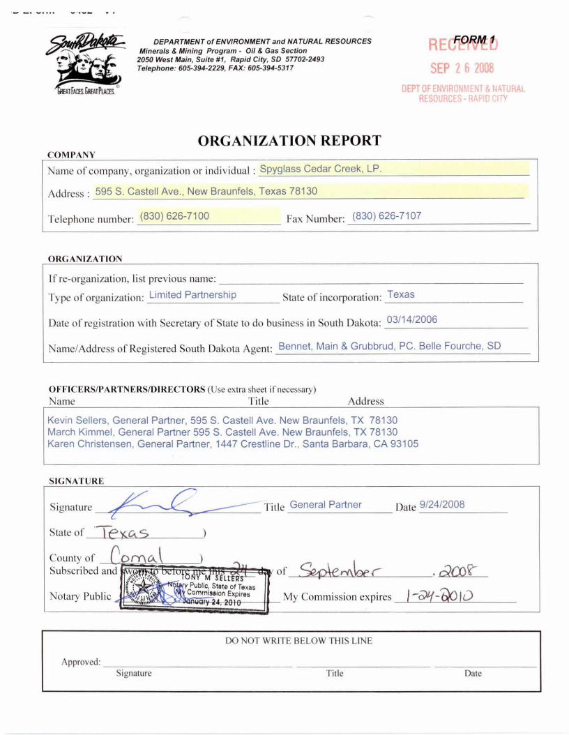
Name of company, organization or individual : Spyglass Cedar Creek, LP.
Address : 595 S. Castell Ave.. New Braunfels, Texas 78130
Telephone number: (830) 626-7100 Fax Number: (830) 626-7107
Approved: Signature Title Date
Signature Title General Partner Date 9/24/2008
State of ey,ctc-
M SEL lit Public, State of Texas
1 ‘‘ :ti 1 Commission Expires -'41LIEV: 1/4, immanzarals■j6,6;da, 11
County of Subscribed and
My Commission expires Notary Public
DO NOT WRITE BELOW THIS LINE
DEPARTMENT of ENVIRONMENT and NATURAL RESOURCES Minerals & Mining Program - Oil & Gas Section
2050 West Main, Suite #1, Rapid City, SD 57702-2493 Telephone: 605-394-2229, FAX: 605-394-5317
RECTM
SEP 2 6 2008
DEPT OF ENVIRONMENT & NATURAL RESOURCES - RAPID CITY
GREAT NIS. GREAT NAM.
ORGANIZATION REPORT COMPANY
ORGANIZATION
If re-organization. I I st previous name:
Type of organization: Limited Partnership State of incorporation: Texas
Date of registration with Secretary of State to do business in South Dakota: 03/14/2006
Name/Address of Registered South Dakota Agent: Bennet, Main & Grubbrud, PC. Belle Fourche, SD
OFFICERS/PARTNERS/DIRECTORS (Use extra sheet if necessary) Name Title
Address
Kevin Sellers, General Partner, 595 S. Castel! Ave. New Braunfels, TX 78130 March Kimmel, General Partner 595 S. Castell Ave. New Braunfels, TX 78130 Karen Christensen, General Partner, 1447 Crestline Dr.. Santa Barbara, CA 93105
SIGNATURE

3000 pi jVIP
al.-2k4P -
Kill Lizia (2"14orminit-11
Aruitter cOnir21 tibiro
C'vni:at VON%
• Plp• ?am Contrei VIOni
Arijua talpi Cbokc
8 lowoyi P1avoJj3107 Sv.0: 01Vact
To Pit
(iQ 2" ll'etainai
\Buterril,ine Ta Pit Nominal
,A4inatabla Cbolcs (ccPositive)
To Fit 2" Nominal
Apr 20 2007 11:42RM 8JOES7107
ATTA,NMENT 2 - EXhiBt7 'A" E09 DIWRAJM
RECEIVE1P-9
SEP 2 6 r. DEPT OF ENVIRONM EN1.
. RESOURCES. RAPID+ roppwwww.b..6.0.a.
H'YDPAI.JUC CLOSIVG LINT fAccnrrrailu:Ti
e, 10 Drilling poD1 Opth)n Le BOP hca ou
0103re. LAD (3" tvtiouctuni)
Choke Mualiald Reccuireirmat {3000 psi WP)
wAnr):21 3one 62 oaC

DEPARTMENT of ENVIRONMENT and NATURAL RESOURCES Minerals & Mining Program - Oil & Gas Section
0 West Main, Suite #1, Rapid City, SD 57702-2493 ephone: 605-394-2229, FAX: 605-394-5317
r
AT FMB. GREAT PLACES
Notary Publ.
TONY M SELLERS • 's Notary Public. State of Texas
My Commission Expires nuar 24 2
FORM 9 RECEIVED
SEP 2 6 2008
DEPT OF ENVIRONMENT & NATURAL RESOURCES - RAPID CITY
CERTIFICATE OF NEGOTIATION WITH SURFACE OWNER/LESSEE
Surface owner/lessees CO e \i f% L 14-e a i re +
Well Name ecx -c }-1- enae(- 3/N 141- H
Township Range i E Section 11 County }4-a rd n
In accordance with SDCL 45-5A, I hereby certify that to the best of my knowledge and belief, an agreement regarding compensation for damages to livestock and surface land resulting from drilling operations on the described property has been or is being negotiated with the surface landowners or lessees, as listed above.
Operator Name:
Sp) 455 Cedar CreeL, LP
ak (-41A e Title
9 i didaoofs
Date
State of
e)(65
Co awl
(Seal)
County of
Subscribed and s e this d day of Se , 20 ck
My Commission expires
ley'OS
CrY\r,t(
Subscribed and
State of
County of
e h* TONY M SELLERS
otary Public, State of Texas My Commission Expires
January 24, 2010 Notary Publ.
DEPARTMENT of ENVIRONMENT and NATURAL RESOURCES Minerals & Mining Program - Oil & Gas Section
2050 West Main, Suite #1, Rapid City, SD 57702-2493 Telephone: 605-394-2229, FAX: 605-394-5317
FORM 8
RECEIVED
SEP 2 b 10G8 AT FACES. 6REAT PLACES.
DEPT OF ENVIRONMENT & NATURAL RESOURCES - RAPID CITY
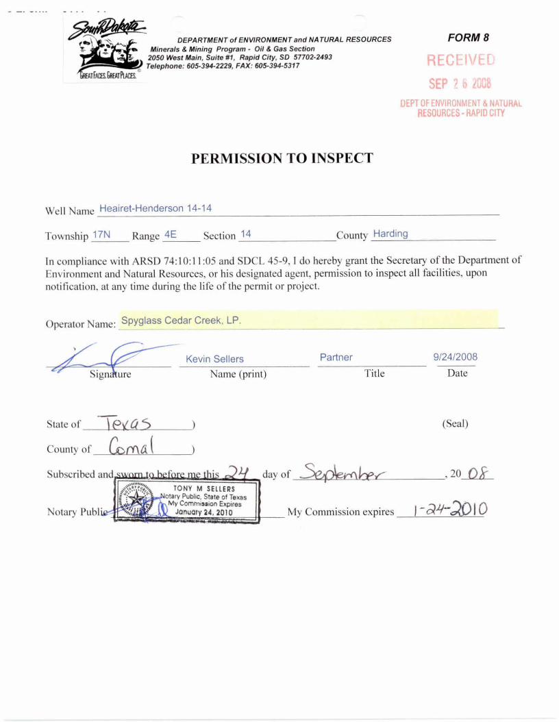
PERMISSION TO INSPECT
Well Name Heairet-Henderson 14-14
Township 17N
Range 4E
Section 14 County Harding
In compliance with ARSD 74:10:11:05 and SDCL 45-9, I do hereby grant the Secretary of the Department of Environment and Natural Resources, or his designated agent, permission to inspect all facilities, upon notification, at any time during the life of the permit or project.
Operator Name: Spyglass Cedar Creek, LP.
Kevin Sellers
Partner 9/24/2008
Name (print)
Title Date
(Seal)
day of
20 Ok
My Commission expires

FORM 13 tituttriEu
SEP 2 6 2008
DEPT OF ENVIRONMENT & NATURAL RESOURCES-RAPID CITY
DEPARTMENT of ENVIRONMENT and NATURAL RESOURCES Minerals & Mining Program - Oil & Gas Section
2050 West Main, Suite #1. Rapid City, SD 57702-2493 Telephone: 605-394-2229, FAX: 605-394-5317
STATE OF SOUTH DAKOTA BEFORE THE SECRETARY OF
THE DEPARTMENT OF ENVIRONMENT AND NATURAL RESOURCES
) )
IN THE MATTER OF THE APPLICATION OF Spyglass Cedar Creek, LP.
CERTIFICATION OF APPLICANT
)
STATE OF State of South Dakota
COUNTY OF Harding
) ) SS
)
I, Spyglass Cedar Creek, LP. , the applicant in the above matter after being duly sworn upon oath hereby certify the following information in regard to this application:
South Dakota Codified Laws Section 1-40-27 provides:
"The secretary may reject an application for any permit filed pursuant to Titles 34A or 45, including any application by any concentrated swine feeding operation for authorization to operate under a general permit, upon making a specific finding that:
(1) The applicant is unsuited or unqualified to perform the obligations of a permit holder based upon a finding that the applicant, any officer, director, partner, or resident general manager of the facility for which application has been made:
(a) Has intentionally misrepresented a material fact in applying for a permit:
(b) Has been convicted of a felony or other crime of moral turpitude;
(c) Has habitually and intentionally violated environmental laws of any state or the United States which have caused significant and material environmental damage;
(d) Has had any permit revoked under the environmental laws of any state or the United States;
(e) Has otherwise demonstrated through clear and convincing evidence of previous actions that the applicant lacks the necessary good character and competency to reliably carry out the obligations imposed by law upon the permit holder; or

.121.41before me this 24 day of September TONY M SELLERS
Notary Public, State of Texas My Commission Expires
anuary 24, 2010
Subscrib , 20 08
Notary Pu
CERTIFICATE OF APPLICATE — FORM 13 PAGE 2
(2) The application substantially duplicates an application by the same applicant denied within the past five years which denial has not been reversed by a court of competent jurisdiction. Nothing in this subdivision may be construed to prohibit an applicant from submitting a new application for a permit previously denied, if the new application represents a good faith attempt by the applicant to correct the deficiencies that served as the basis for the denial in the original application.
All applications filed pursuant to Titles 34A and 45 shall include a certification, sworn to under oath and signed by the applicant, that he is not disqualified by reason of this section from obtaining a permit. In the absence of evidence to the contrary, that certification shall constitute a prima facie showing of the suitability and qualification of the applicant. If at any point in the application review recommendation, or hearing process, the secretary finds the applicant has intentionally made any material misrepresentation of fact in regard to this certification, consideration of the application may be suspended and the application may be rejected as provided for under this section.
Applications rejected pursuant to this section constitute final agency action upon that application and may be appealed to circuit court as provided for under chapter 1-26."
Pursuant to SDCL 1-40-27, I certify that I have read the forgoing provision of state law, and that I am not disqualified by reason of that provision from obtaining the permit for which application has been made.
Dated this 24 day of September , 20 08
Applicant
My commission expires:
(SEAL)
PLEASE ATTACH SHEET DISCLOSING ALL FACTS PERTAINING TO SDCL 1-40-27 (1)(a) THROUGH (e).
ALL VIOLATIONS MUST BE DISCLOSED, BUT WILL NOT AUTOMATICALLY RESULT IN THE REJECTION OF AN APPLICATION.

SIII0da2l MODS / NOIIDadSICI TlaAk

NO WELL INSPECTION OR SCOUT REPORTS FOR THIS WELL
AS OF 8/1/2011

ScIVW / SIII0da2l
S GllOIVIlad0

NO OPERATOR'S TECHNICAL REPORTS OR MAPS FOR THIS WELL
AS OF 8/1/2011

ADMINISTRATIVE / SUNDRY REPORTS

April 24, 2012 Shari Mills Spyglass Cedar Creek, LP 1919 NW Loop 410, Suite 200 San Antonio, TX 78213 Dear Ms. Mills: The Minerals and Mining Program is in the process of updating oil and gas maps for the state. The Jumpoff Field has been defined as T17N, R3-5E and T18N, R3-5E for the purposes of tracking production data only. Please note that this determination has been made only for administrative purposes, and does not affect any board orders issued for the area. If you have any questions or concerns you would like to discuss, please feel free to contact me at 605.773.4201. Thank you for your attention to these issues. Sincerely,
Lucy Dahl Oil and Gas Geologist Minerals and Mining Program

Tit
2D 0 C Conditions, i an
DatVEC 1 6 ?Onn
/c 3e)
Approved by:
DE. .RTMENT of ENVIRONMENT and NATURAL RESCIUk -CS Minerals & Mining Program - Oil & Gas Section 2050 West Main, Suite #1, Rapid City, SD 57702-2493 Telephone: 605-394-2229, FAX: 605-394-5317
FORM 6
UEIh U r 2009
DEPTOFENVIRONMENT&NATURAt FATFACES.CREATNCES. RESOURCES - RAPID My
SUNDRY NOTICE AND REPORT ON WELLS Operator Name Telephone
Spyglass Cedar Creek, LP (830) 626 -7100
Address
595 S. Castell Ave. New Braunfels, TX 78130
Permit # API No. Well Name and Number Location (Qtr-Qtr, Sec, Twp, Rge, County)
1892 40 063 20664 Heairet-Henderson 14-14 SESW, Sec 14, T17N R4E, Harding
Notice
❑
Plug Pull, Perforate Acidize Fracture Squeeze Other
of Intention
Temporarily
To:
Abandon and Abandon Alter, or Test Casing
Treatment Cement
Extend Expir.
Subsequent Report of : Request for change of:
El Location Elevation
❑ Producing Method ❑ Producing Formation ❑ Injection Pressure
❑ Injection Volume
❑ Injection Fluid ❑ Other
Drilling Progress ❑ BOP Pressure Test/Program ❑ Gas/Oil Ratio ❑ Work-Over (Perf, Frac, Acidize)
❑ Shut-In Pressure
❑Spill
____ ❑ ❑ ❑
❑ Mechanical Integrity Test X Permit ❑ Other
Describe Proposed or Completed Operations (clearly state all pertinent details, and give pertinent dates, including estimated date of starting any proposed work). Use additional page(s) if appropriate.
The Heairet-Henderson 14-14 was permitted on 10/30/2008 and the permit is expired.
Please extend the expiration date on this permit so that we may have the opportunity
to drill it during our next drilling phase in 2010. .
I hereby certify that the foregoing as to any work or operation performed is a true and correct report of such work or operation.
7
7----1.---N___ Kevin Sellers Partner 12/04/2009 Signature Name (Print) Title Date
FOR OFFICE USE ONLY
CORRESPONDENCE

GrAI FACES. GflEAT PLACES.
September 29, 2008
DEPARTMENT of ENVIRONMENT and NATURAL RESOURCES
Minerals & Mining Program Oil & Gas Office
2050 West Main Street, Suite #1 Rapid City, SD 57702-2493
Telephone: 605-394-2229 Fax: 605-394-5317
Stan Michals Department of Game, Fish and Parks 4725 Jackson Boulevard
Rapid City. South Dakota 57701
Dear Mr. Michals:
The Department of Environment and Natural Resources has received tour applications from Spyglass Cedar Creek, LP to drill new gas wells in !larding County. The legal descriptions for
the wells are as tbllows:
SWNE Section 9, Township 17 North, Range 4 East SESW Section 14. Township 17 North. Range 4 East SENW Section 27, Township 17 North. Range 4 East NWNW Section 15. Township 18 North. Range 4 East
Please direct your regulatory requirements to the operator as follows:
Spyglass Cedar Creek, LP
595 S. Castell Avenue New Braunfels, Texas 78130
I plan to issue the permits after October 3 2008. If you have any questions, please do not hesitate to contact me.
SincA rely,
Fred V. Stet:cc Oil and Gas Supervisor

September 29, 2008
GREAT FACES. GREAT PLACES.
DEPARTMENT of ENVIRONMENT and NATURAL RESOURCES
Minerals & Mining Program Oil & Gas Office
2050 West Main Street, Suite #1 Rapid City, SD 57702-2493
Telephone: 605-394-2229 Fax: 605-394-5317
Michael Fosha Archaeological Research Center P. O. Box 1257 Rapid City, SD 57709-1257
Dear Mr. Fosha:
The Department of Environment and Natural Resources has received four applications from Spyglass Cedar Creek, LP to drill new gas wells in Harding County, South Dakota. The legal descriptions for the wells are as follows:
SW NE Section 9, Township 17 North, Range 4 East --SESW Section 14, Township 17 North, Range 4 East
SENW Section 27, Township 17 North, Range 4 East NWNW Section 15, Township 18 North, Range 4 East
Please direct your regulatory requirements to the operator as follows:
Spyglass Cedar Creek, LP 595 S. Castell Avenue New Braunfels, Texas 78130
I plan to issue the permits after October 3, 2008. If you have any questions, please do not hesitate to contact me.
Sin trely,
/Fred V. Steece Oil and Gas Supervisor

-cly,
Fred V. Steece Oil and Gas Supervisor
DEPARTMENT of ENVIRONMENT and NATURAL RESOURCES
Minerals & Mining Program Oil & Gas Office
2050 West Main Street, Suite #1 Rapid City, SD 57702-2493
Telephone: 605-394-2229 Fax: 605-394-5317
September 29, 2008
Kathy Glines Harding County Zoning Director P. O. Box 26 Buffalo, South Dakota 57720
Dear Ms. Glines:
The Department of Environment and Natural Resources has received four applications from Spyglass Cedar Creek, LP to drill new gas wells in Harding County. The legal descriptions for the wells arc as follows:
SWNE Section 9, Township 17 North, Range 4 East t/SESW Section 14, Township 17 North, Range 4 East
SENW Section 27, Township 17 North, Range 4 East NWNW Section 15, Township 18 North, Range 4 East
1 plan to issue the permits after October 3, 2008. If you have any questions, please do not hesitate to contact me.

MISCELLANEOUS

NO MISCELLANEOUS INFORMATION FOR THIS
WELL AS OF 8/25/2014