Embed Size (px)
Citation preview
Country profile – United Arab Emirates
Version 2008
Recommended citation: FAO. 2008. AQUASTAT Country Profile – United Arab Emirates.
Food and Agriculture Organization of the United Nations (FAO). Rome, Italy
The designations employed and the presentation of material in this information product do not imply the expression of any opinion whatsoever on the part of the Food and Agriculture Organization of the United Nations (FAO) concerning the legal or development status of any country, territory, city or area or of its authorities, or concerning the delimitation of its frontiers or boundaries. The mention of specific companies or products of manufacturers, whether or not these have been patented, does not imply that these have been endorsed or recommended by FAO in preference to others of a similar nature that are not mentioned. The views expressed in this information product are those of the author(s) and do not necessarily reflect the views or policies of FAO. FAO encourages the use, reproduction and dissemination of material in this information product. Except where otherwise indicated, material may be copied, downloaded and printed for private study, research and teaching purposes, or for use in non-commercial products or services, provided that appropriate acknowledgement of FAO as the source and copyright holder is given and that FAO’s endorsement of users’ views, products or services is not implied in any way. All requests for translation and adaptation rights, and for resale and other commercial use rights should be made via www.fao.org/contact-us/licencerequest or addressed to [email protected]. FAO information products are available on the FAO website (www.fao.org/ publications) and can be purchased through [email protected]. © FAO 2008

1
United Arab Emirates
GEOGRAPHY, CLIMATE AND POPULATION
Geography
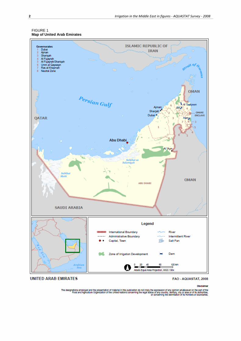
The United Arab Emirates (UAE) is a federation of seven emirates: Abu Dhabi, Dubai, Shariqah, Ras
Al Khaymah, Fujayrah, Umm Al Qaywayn and Ajman. By far the largest emirate is Abu Dhabi and Abu
Dhabi City is the capital of both the emirate and the whole country. The UAE is situated in the eastern
corner of the Arabian Peninsula and is bordered in the north by the Persian Gulf, in the east by the Gulf
of Oman and Oman and in the south and west by Saudi Arabia. Six of the seven emirates lie on the coast
of the Persian Gulf, while the seventh, Fujayrah, is situated on the eastern coast of the peninsula and has
direct access to the Gulf of Oman.
The total area of the UAE is about 83 600 km2 (Table 1), of which 77 700 km2 is the mainland surface
area, where the population lives. The Abu Dhabi Emirate represents almost 87 percent of the mainland
area (Table 2). The coast stretches over a shallow marine area, with many islands and coral reefs. The
total area of the many - and generally uninhabited - islands is about 5 900 km2. The UAE can be divided
into three ecological areas: the northeastern mountain areas, sandy/desert areas and marine coastal areas;
80 percent of the area of the UAE is desert, especially the western area (MOEW, 2006).
TABLE 1 Basic statistics and population
Physical areas
Area of the country 2005 8 360 000 ha
Cultivated area (arable land and area under permanent crops) 2003 254 918 ha
as % of the total area of the country 2003 3 %
arable land (annual crops + temp. fallow + temp. meadows) 2003 64 530 ha
area under permanent crops 2003 190 388 ha
Population
Total population 2005 4 496 000 inhabitants
of which rural 2005 14.5 %
Population density 2005 53.8 inhabitants/km2
Economically active population 2005 2 666 000 inhabitants
as % of total population 2005 59.3 %
female 2005 14.4 %
male 2005 85.6 %
Population economically active in agriculture 2005 103 000 inhabitants
as % of total economically active population 2005 3.9 %
female 2005 0 %
male 2005 100 %
Economy and development
Gross Domestic Product (GDP) (current US$) 2005 129 700 million US$/yr
value added in agriculture (% of GDP) 2005 2 %
GDP per capita 2005 28 848 US$/yr
Human Development Index (highest = 1) 2005 0.868
Access to improved drinking water sources
Total population 2006 100 %
Urban population 2006 100 %
Rural population 2006 100 %
2 Irrigation in the Middle East in figures - AQUASTAT Survey - 2008
FIGURE 1 Map of United Arab Emirates
United Arab Emirates 3
TABLE 2 Mainland area and farms by emirates
Emirate
Mainland area, excl. islands
Farms in 2003
Area (km²) % Number Area (ha)
Abu Dhabi 67 340 86.7 22 985 218 590
Dubai 3 885 5.0 1 326 6 176
Sharjah 2 590 3.3 4 392 13 275
Ras Al Khaimah 1 683.5 2.2 4 465 13 571
Fujairah 1 165.5 1.5 4 346 5 324
Umm Al Qaiwain 777 1.0 343 1 693
Ajman 259 0.3 691 2 104
Total 77 700 100.0 38 548 260 732
From 1994 to 2003, the agricultural area more than tripled to reach 260 732 ha (Table 2). In 2003 the
cultivated area was around 254 918 ha, of which 75, 16 and 9 percent consisted in permanent crops,
annual crops and shifting areas respectively (Table 3).
TABLE 3 Cultivated area by emirate in 2003 (Ministry of Environment and Water)
Emirate Abu
Dhabi Dubai Sharjah Ajman
Umm Al Quwain
Ras Al Khaimah
Fujairah Total
Palm tree 172 080 1 519 4 824 502 385 3 762 2 258 185 330
Other permanent crops 340 584 1 551 357 182 1 066 978 5 058
Crop and Fodder 24 719 804 1 599 248 289 2 419 359 30 437
Vegetables 3 826 750 1 667 184 176 2 446 721 9 769
Greenhouses 144 3 23 2 2 55 19 247
Shifting area 13 202 2 257 3 244 682 334 3 498 860 24 077
Cultivated area 214 311 5 917 12 909 1 975 1 367 13 246 5 193 254 918
Climate
The climate is arid with very high summer temperatures. The coastal area, where the bulk of the
population lives, has a hot and humid climate in the summer with temperatures and relative humidity
reaching 46°C and 100 percent respectively. Winters are generally mild with temperatures between 14°C
and 23°C. The interior desert region has hot summers with temperatures rising to about 50°C and cool
winters during which the lowest temperature can fall to around 4°C.
Mean annual rainfall is about 78 mm, ranging from less than 40 mm around Liwa in the southern desert
to 160 mm in the northeastern mountains. Precipitations cover a period of between 9 and 19 days over
the whole year. Over 80 percent of the annual rainfall occurs during the winter (December to March).
In spring (April–May) rainfall is infrequent and is usually associated with isolated thunderstorms. In
summer (June–September), rain is rare and occurs as a result of the afternoon thunderstorm over the
eastern highlands or isolated thunderstorms accompanying the rarely occurring sea breeze fronts. On a
very few occasions, the Inter-Tropical Convergence Zone (ITCZ) may move northwards and give some
rainfall over the area. The most settled weather conditions with very little rain prevail in the autumn
(October–November), especially in October (MOEW, 2006).
Population
Total population is almost 4.5 million (2005), of which 14.5 percent is rural (Table 1). The average
annual demographic growth rate was estimated at 6.7 percent during the period 2000–2005. The average
population density is about 54 inhabitants/km2.
Abu Dhabi has the largest population numerically, but it also has the lowest population density among
the emirates. Dubai, which has the highest population density, is considered the business capital and the
most important port in the country. Over two-thirds of the total population is concentrated in these two
4 Irrigation in the Middle East in figures - AQUASTAT Survey - 2008
emirates. The male population accounted for over 68 percent of the total population in 2005, mainly
because of the male immigrant labour force.
In 2006, 97 percent of the population had access to improved sanitation (98 and 95 percent in urban and
rural areas respectively) and the whole population had access to improved water sources.
ECONOMY, AGRICULTURE AND FOOD SECURITY
In 2005, the national Gross Domestic Product (GDP) of the United Arab Emirates was US$129.7 billion.
The main source of income is the revenue from oil exports. The total economically active population
was 2.7 million (59 percent of the total population), of which 86 percent was male and 14 percent female.
Agriculture employed an estimated 4 percent of the labour force and accounted for 2 percent of the
country’s GDP. The entire labour force working in agriculture is male.
For management purposes, the former Ministry of Agriculture and Fisheries (MAF) (current Ministry
of Environment and Water (MOEW)) has divided the area it covers (i.e. all the Emirates except Abu
Dhabi) into three zones or districts as follows: Eastern (Fujayrah and Shariqah), Central (Dubai, Part of
Shariqah, Umm Al Qaywayn, Ajman and part of Ras Al Khaymah), and Northern (most of Ras Al
Khaymah). This division is not related to the borders of the Emirates or any other administrative
partitioning. The total number of farms in the UAE is 38 548 (2003), of which 60 percent in Abu Dhabi,
16 percent in the Central and Eastern zones and the remainder in the Northern zone. Farms produce
primarily date palms, fodder and vegetable crops. The government purchases date production from
farmers at a maximum of 70 kg per tree and at a price depending on quality. Fodder production is also
purchased by the government but only in the Abu Dhabi Emirate. In the other emirates, fodder is sold
in the local market for local consumption or for export to neighbouring countries. The same applies to
vegetable crops throughout the country.
In each of the three zones it covers, the MAF has a centre staffed with engineers and technicians to
support farmers. The services to farmers focus on the provision of subsidies, for example for cultivation
(free of charge), crop protection (50 percent free with the exception of general campaigns which are
totally free), veterinary services and fertilizers (50 percent free). This system of subsidies does not
concern private companies specialized in the intensive production of vegetable crops. Some extension
advisory services are also provided, but they deal mainly with agricultural practices; advisory services
for irrigation are actually lacking for several reasons including the fact that the extension staff are not
qualified in this area. The number of extension agents is 46, 8, 13 and 13, respectively in Abu Dhabi,
the Eastern, the Central and the Northern zones (FAO, 2004).
In the UAE, traditional knowledge and traditions are very important. While creating a modern country,
the government aims to conserve the heritage of the past. Today’s UAE residents come from different
Arabian groups, some of which had a traditional nomadic lifestyle, breeding camels and goats; most of
them were settled in the Liwa Oasis to work in simple agriculture and palm plantations. In the coastal
area, groups used to work in fishing and pearl hunting. In the Al Ain Oasis, other groups work in
agriculture, especially in date plantations using underground water and aflaj irrigation. In the northern
emirates where, relatively, there is more rainfall, people can work in agriculture all year round. In the
Hajjar Mountains of Al Fujayrah, terrace farming is practised, while in Dubai, Shariqah & Galfar (Ras
Al Khaymah) people are trading with boats and modern ships (MOEW, 2006).
WATER RESOURCES
The total annual renewable water resources are about 150 million m3, but there are no perennial streams
(Table 4). Groundwater resources occur in the upper clastic and lower carbonate formations located in
the Bajada region in the eastern part of the country. The aquifers consist of alluvial fan deposits along
the base of the Oman and Ras Al Khaymah mountains extending over a large area. The upper aquifer is
composed of gravel sand and silt, the lower aquifer of limestone, dolomite and marl. Both aquifers range
United Arab Emirates 5
in thickness from 200 to 800 metres. In addition, the Dammam and Umm er Radhuma formations extend
into the western desert areas, with thicknesses ranging from 500 to 1 000 metres. Groundwater quality
in the two aquifer systems, particularly in the Bajada region, ranges from 600 to 2 000 ppm. The
Dammam and Umm er Radhuma aquifers contain highly saline water (ESCWA, 2001). Average annual
groundwater recharge may be estimated at about 120 million m3, most of which comes from infiltration
from the river beds.
TABLE 4 Water resources
Renewable freshwater resources
Precipitation (long-term average) - 78 mm/yr
- 6.521 109 m3/yr
Internal renewable water resources (long-term average) - 0.15 109 m3/yr
Total actual renewable water resources - 0.15 109 m 3/yr
Dependency ratio - 0 %
Total actual renewable water resources per inhabitant 2005 48.29 m3/yr
Total dam capacity 2006 118 106 m3
To increase the groundwater recharge, a number of dams have been built at various locations in the
country. In 2003, there were 114 dams and embankments of various dimensions with a total storage
capacity of 118 million m3, which is an increase of almost 48 percent compared to 1995, but total water
stored was only 12.3 million m3. While most of these dams are basically built for recharging purposes,
they also provide protection against damage caused by flash floods.
The first desalination plant was installed in Abu Dhabi in 1976 with a total capacity of 250 m3/day.
Because of a rapid increase in municipal and industrial water demand more plants were installed,
particularly in Abu Dhabi and Dubai. In 2002, the total installed gross desalination capacity (design
capacity) in the United Arab Emirates was 4 725 346 m3/day or 1 725 million m3/year (Wangnick
Consulting, 2002). In 2005, total desalinated water produced was 950 million m3, compared to
385 million m3 in 1995, meaning an increase of almost 150 percent in ten years. Desalination provides
most of the municipal supply.
In 1995 the total wastewater produced was about 500 million m3. About 289 million m3 of this water
was treated in 2006 of which around 86 percent was reused. The amount of sewage water increases
according to the size of the town and its population. The UAE have been pioneers in this field as regards
the Gulf Area. Sewage water is subjected to tertiary treatment and then used in landscaping work in and
around the towns. Due to the increase in the amount of such treated water, studies and research are being
done as to whether this kind of water can be used to irrigate vegetables and fruit trees or can even be
injected into the groundwater (MOEW, 2006)
WATER USE
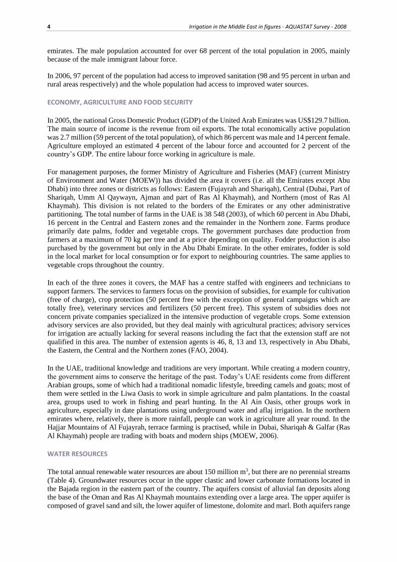
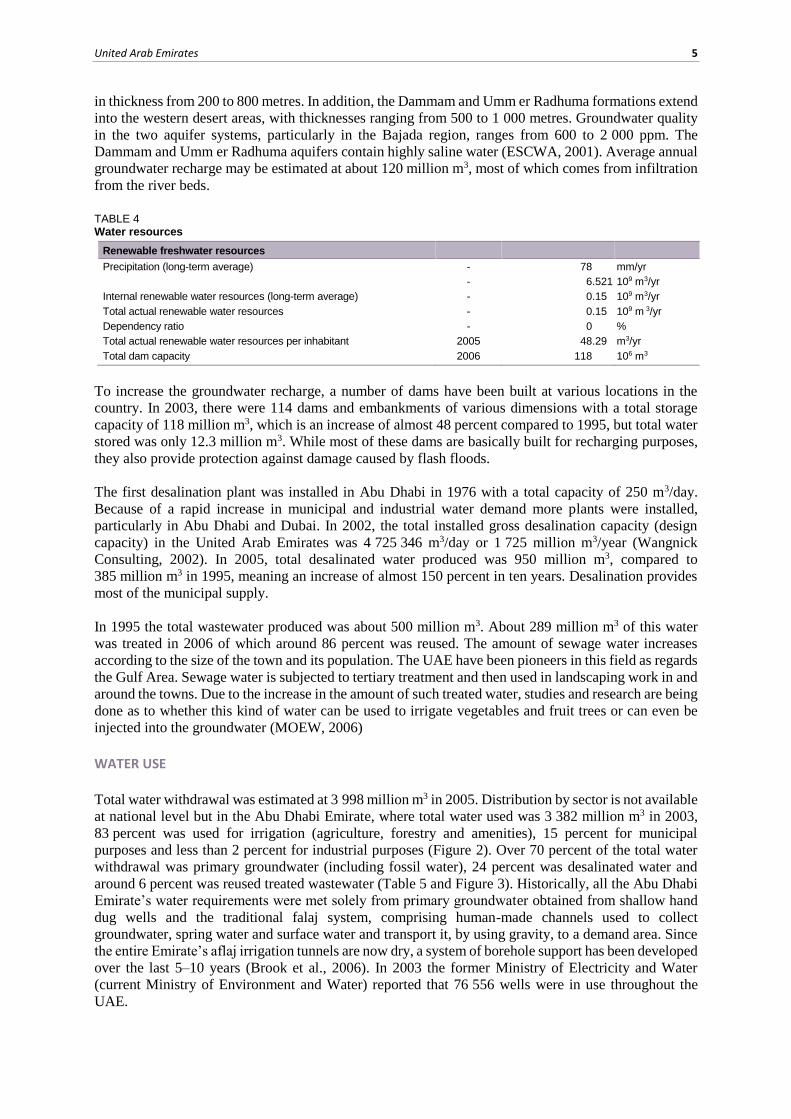
Total water withdrawal was estimated at 3 998 million m3 in 2005. Distribution by sector is not available
at national level but in the Abu Dhabi Emirate, where total water used was 3 382 million m3 in 2003,
83 percent was used for irrigation (agriculture, forestry and amenities), 15 percent for municipal
purposes and less than 2 percent for industrial purposes (Figure 2). Over 70 percent of the total water
withdrawal was primary groundwater (including fossil water), 24 percent was desalinated water and
around 6 percent was reused treated wastewater (Table 5 and Figure 3). Historically, all the Abu Dhabi
Emirate’s water requirements were met solely from primary groundwater obtained from shallow hand
dug wells and the traditional falaj system, comprising human-made channels used to collect
groundwater, spring water and surface water and transport it, by using gravity, to a demand area. Since
the entire Emirate’s aflaj irrigation tunnels are now dry, a system of borehole support has been developed
over the last 5–10 years (Brook et al., 2006). In 2003 the former Ministry of Electricity and Water
(current Ministry of Environment and Water) reported that 76 556 wells were in use throughout the
UAE.
6 Irrigation in the Middle East in figures - AQUASTAT Survey - 2008
TABLE 5 Water use
Water withdrawal
Total water withdrawal 2005 3 998 106 m3/yr
- irrigation + livestock 2005 3 312 106 m3/yr
- municipalities 2005 617 106 m3/yr
- industry 2005 69 106 m3/yr
per inhabitant 2005 889.2 m3/yr
Surface water and groundwater withdrawal 2005 3 048 106 m3/yr
as % of total actual renewable water resources 2005 2 032 %
Non-conventional sources of water
Produced wastewater 1995 500 106 m3/yr
Treated wastewater 2006 289 106 m3/yr
Reused treated wastewater 2005 248 106 m3/yr
Desalinated water produced 2005 950 106 m3/yr
Reused agricultural drainage water - 106 m3/yr
FIGURE 2 Water withdrawal by sector Total 3.998 km3 in 2005
FIGURE 3 Water withdrawal by source Total 3.998 km3 in 2005
United Arab Emirates 7
Groundwater depletion is hard to estimate because there is no information on the possible annual
recharge of groundwater entering from neighbouring countries (for example from the Eastern Arabia
Aquifer). In any case, the overextraction of groundwater resources is real and has led to a lowering of
the groundwater table, while sea water intrusion is increasing in the coastal areas.
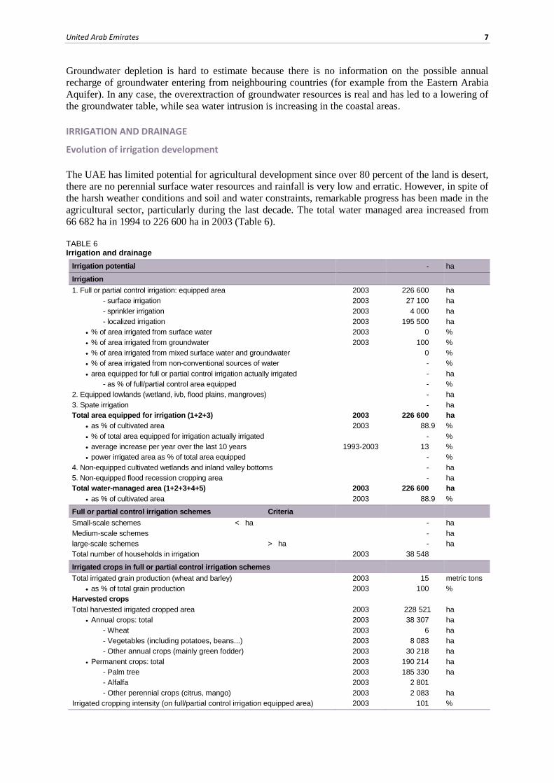
IRRIGATION AND DRAINAGE
Evolution of irrigation development
The UAE has limited potential for agricultural development since over 80 percent of the land is desert,
there are no perennial surface water resources and rainfall is very low and erratic. However, in spite of
the harsh weather conditions and soil and water constraints, remarkable progress has been made in the
agricultural sector, particularly during the last decade. The total water managed area increased from
66 682 ha in 1994 to 226 600 ha in 2003 (Table 6).
TABLE 6 Irrigation and drainage
Irrigation potential - ha
Irrigation
1. Full or partial control irrigation: equipped area 2003 226 600 ha
- surface irrigation 2003 27 100 ha
- sprinkler irrigation 2003 4 000 ha
- localized irrigation 2003 195 500 ha
% of area irrigated from surface water 2003 0 %
% of area irrigated from groundwater 2003 100 %
% of area irrigated from mixed surface water and groundwater 0 %
% of area irrigated from non-conventional sources of water - %
area equipped for full or partial control irrigation actually irrigated - ha
- as % of full/partial control area equipped - %
2. Equipped lowlands (wetland, ivb, flood plains, mangroves) - ha
3. Spate irrigation - ha
Total area equipped for irrigation (1+2+3) 2003 226 600 ha
as % of cultivated area 2003 88.9 %
% of total area equipped for irrigation actually irrigated - %
average increase per year over the last 10 years 1993-2003 13 %
power irrigated area as % of total area equipped - %
4. Non-equipped cultivated wetlands and inland valley bottoms - ha
5. Non-equipped flood recession cropping area - ha
Total water-managed area (1+2+3+4+5) 2003 226 600 ha
as % of cultivated area 2003 88.9 %
Full or partial control irrigation schemes Criteria
Small-scale schemes < ha - ha
Medium-scale schemes - ha
large-scale schemes > ha - ha
Total number of households in irrigation 2003 38 548
Irrigated crops in full or partial control irrigation schemes
Total irrigated grain production (wheat and barley) 2003 15 metric tons
as % of total grain production 2003 100 %
Harvested crops
Total harvested irrigated cropped area 2003 228 521 ha
Annual crops: total 2003 38 307 ha
- Wheat 2003 6 ha
- Vegetables (including potatoes, beans...) 2003 8 083 ha
- Other annual crops (mainly green fodder) 2003 30 218 ha
Permanent crops: total 2003 190 214 ha
- Palm tree 2003 185 330 ha
- Alfalfa 2003 2 801
- Other perennial crops (citrus, mango) 2003 2 083 ha
Irrigated cropping intensity (on full/partial control irrigation equipped area) 2003 101 %

8 Irrigation in the Middle East in figures - AQUASTAT Survey - 2008
TABLE 6 (continued) Irrigation and drainage
Drainage – Environment
Total drained area - ha
- part of the area equipped for irrigation drained - ha
- other drained area (non-irrigated) - ha
drained area as % of cultivated area - %
Flood-protected areas - ha
Area salinized by irrigation - ha
Population affected by water-related diseases - inhabitants
The main agricultural areas are located in the northeast (Ras Al Khaymah), in the east along the coast
from Kalba to Dibba (Fujayrah), in the southeast (Al Ain/Abu Dhabi) and in the central region
(Dhaid/Abu Dhabi).
Prior to the introduction of modern irrigation systems (sprinkler and localized irrigation), all agricultural
land was irrigated by traditional flood and furrow methods. Extensive research was carried out during
the period 1976–81 to select suitable irrigation systems, a pilot farm was established in 1983 to introduce
sprinkler and localized irrigation systems and a subsidy was given to the farmers. These irrigation
systems are believed to have saved about 60 percent of the irrigation water. In 2003, the total equipped
area for full or partial control irrigation was 226 600 ha, of which 195 500 ha used localized irrigation,
27 100 ha surface irrigation and only 4 000 ha sprinklers (Figure 4). All irrigation water is groundwater.
FIGURE 4 Irrigation techniques Total 226 600 ha in 2003
Apart from the government’s experimental farms, nurseries, afforestation schemes and public gardens,
all the agricultural land is owned and developed by private owners. In 2003, 61 percent of the farm
holdings (23 421 units) owned modern irrigation systems (Table 7). More than 86 percent of the farms
with modern irrigation systems are in the Abu Dhabi Emirate, and 9, 4 and 1 percent in the Central,
Northern and Eastern zones respectively (Environmental and Agricultural Information Centre, 2007). TABLE 7 Number and area of farms practicing sprinkler and localized irrigation in 2003 (Ministry of Environment and Water)
Region/Zone N˚ of farms Area
Drip Bubbler Sprinkler Other Total
Abu Dhabi 20 227 145 335 19 939 18 046 3 499 186 818
Central 2 015 1 444 2 231 1 424 821 5 919
Northern 842 1 651 1 110 1 724 1 061 5 546
Eastern 337 197 774 160 0 1 131
Total 23 421 148 627 24 053 21 354 5 380 199 414
United Arab Emirates 9
Role of irrigation in agricultural production, the economy and society
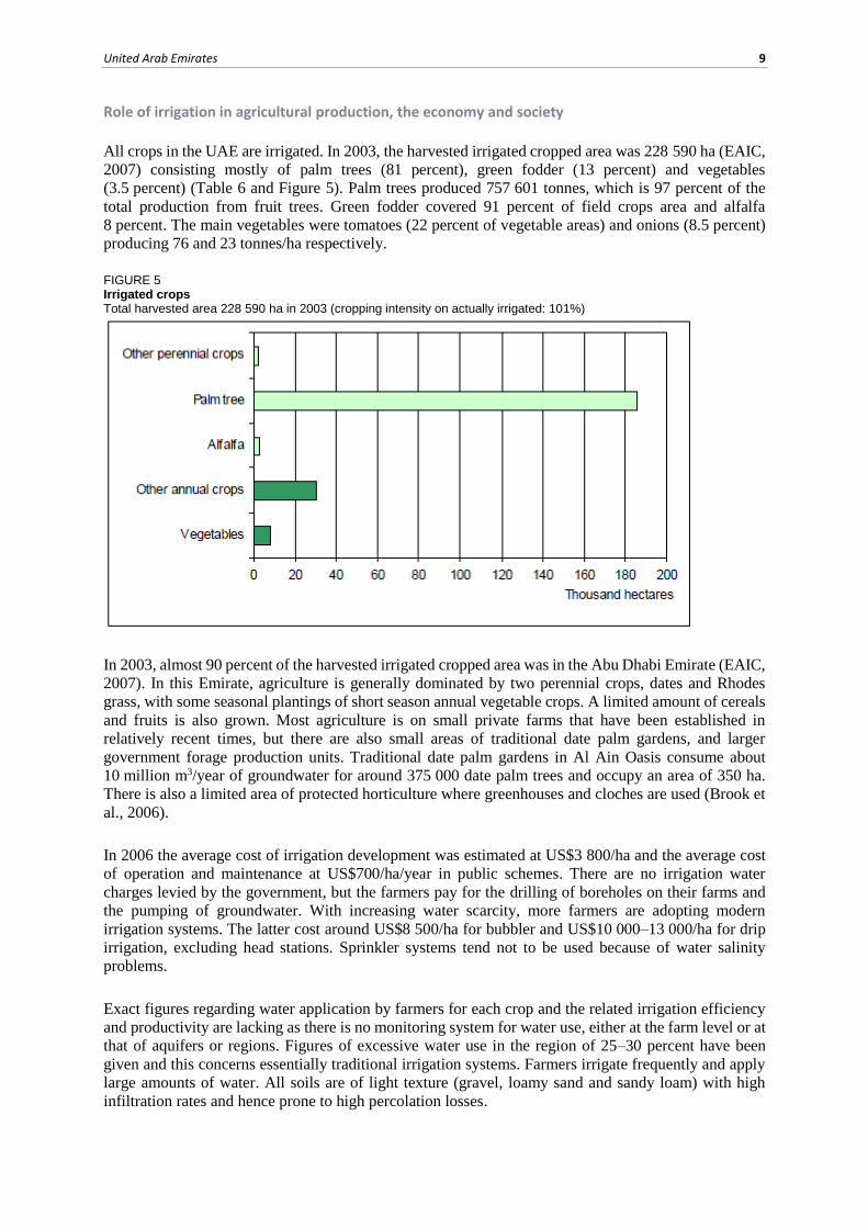
All crops in the UAE are irrigated. In 2003, the harvested irrigated cropped area was 228 590 ha (EAIC,
2007) consisting mostly of palm trees (81 percent), green fodder (13 percent) and vegetables
(3.5 percent) (Table 6 and Figure 5). Palm trees produced 757 601 tonnes, which is 97 percent of the
total production from fruit trees. Green fodder covered 91 percent of field crops area and alfalfa
8 percent. The main vegetables were tomatoes (22 percent of vegetable areas) and onions (8.5 percent)
producing 76 and 23 tonnes/ha respectively.
FIGURE 5 Irrigated crops Total harvested area 228 590 ha in 2003 (cropping intensity on actually irrigated: 101%)
In 2003, almost 90 percent of the harvested irrigated cropped area was in the Abu Dhabi Emirate (EAIC,
2007). In this Emirate, agriculture is generally dominated by two perennial crops, dates and Rhodes
grass, with some seasonal plantings of short season annual vegetable crops. A limited amount of cereals
and fruits is also grown. Most agriculture is on small private farms that have been established in
relatively recent times, but there are also small areas of traditional date palm gardens, and larger
government forage production units. Traditional date palm gardens in Al Ain Oasis consume about
10 million m3/year of groundwater for around 375 000 date palm trees and occupy an area of 350 ha.
There is also a limited area of protected horticulture where greenhouses and cloches are used (Brook et
al., 2006).
In 2006 the average cost of irrigation development was estimated at US$3 800/ha and the average cost
of operation and maintenance at US$700/ha/year in public schemes. There are no irrigation water
charges levied by the government, but the farmers pay for the drilling of boreholes on their farms and
the pumping of groundwater. With increasing water scarcity, more farmers are adopting modern
irrigation systems. The latter cost around US$8 500/ha for bubbler and US$10 000–13 000/ha for drip
irrigation, excluding head stations. Sprinkler systems tend not to be used because of water salinity
problems.
Exact figures regarding water application by farmers for each crop and the related irrigation efficiency
and productivity are lacking as there is no monitoring system for water use, either at the farm level or at
that of aquifers or regions. Figures of excessive water use in the region of 25–30 percent have been
given and this concerns essentially traditional irrigation systems. Farmers irrigate frequently and apply
large amounts of water. All soils are of light texture (gravel, loamy sand and sandy loam) with high
infiltration rates and hence prone to high percolation losses.
10 Irrigation in the Middle East in figures - AQUASTAT Survey - 2008
WATER MANAGEMENT, POLICIES AND LEGISLATION RELATED TO WATER USE IN AGRICULTURE
Institutions
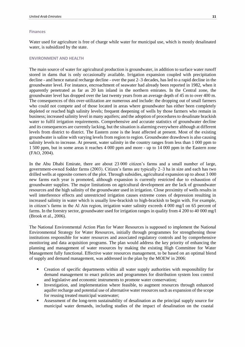
There are four main institutions involved in water resources management:
The Ministry of Environment and Water (MOEW) is responsible of protecting and developing
ecosystems and developing and sustaining water resources, livestock and agriculture.
Abu Dhabi is covered by the Abu Dhabi Administration of Municipalities and Agriculture
(ADAMA), which is directly under the Governor of Abu Dhabi. The Directorate of Irrigation
and Soils of the former Ministry of Agriculture and Fisheries (MAF) was in charge of
promoting irrigated agriculture and for the planning, investigation and management of
groundwater resources, the investigation of quality and salinization of soil due to irrigation,
the construction of dams for flood control and groundwater recharge, the operation and
maintenance of the hydro-meteorological network, the operation of laboratories and designing
of the irrigation networks.
Local government water departments and authorities especially in the emirates of Abu Dhabi,
Dubai and Shariqah are independently responsible for the supply of drinking water and all
water affairs in their respective emirates.
The Federal Environmental Agency has the power to control and regulate water pollution.
Table 8 shows the agencies and their responsibilities in the water sector in the Abu Dhabi Emirate.
TABLE 8 Current responsibilities in the water sector in Abu Dhabi Emirate (Brook et al., 2006)
Government Agency Responsibility
Abu Dhabi Water and Electricity Authority (ADWEA) Supply and distribution of drinking water
Environment Agency Abu Dhabi (EAD) Management, monitoring, assessment and regulation of groundwater and protection against pollution
Municipalities & Agriculture Development of agriculture irrigation
Municipalities & Agriculture (Abu Dhabi) Development of forestry irrigation
Diwan of Eastern Region Development of forestry irrigation
Municipalities & Agriculture (Al Ain) Management of sewerage and waste water treatment Eastern Region
Municipalities & Agriculture (Abu Dhabi) Sewage Projects Committee
Management of sewerage and waste water treatment Western Region
Regulation and Supervision Bureau Regulation of drinking water and sewerage / Waste water treatment
Ministry of Communications Meteorological monitoring and assessment
Ministry of Presidential Affairs Dept of Atmospheric Studies (formerly DWRS)
Meteorological monitoring and assessment
Abu Dhabi National Oil Company (ADNOC)/National Drilling Company (NDC)/USGS
Specialist groundwater research (Eastern Region)
Water management
The Directorate of Irrigation and Soils, both through its headquarters in the former Ministry of
Agriculture and Fisheries (MAF) and its decentralized centres in the three zones, supported farmers free
of charge for the survey and design of modern irrigation systems. Fifty percent of the costs of these
systems, which include bubbler, drip and sprinkler irrigation, are subsidized by the government. At
present, these systems cover 55, 21 and 75 percent of the total irrigated areas in the Central, Eastern and
Northern zones respectively. In the Abu Dhabi emirate however, the percentage is over 90 percent
(2003).
The Emirate of Al Sharja has recently decreed the mandatory conversion of its entire irrigated area to
modern irrigation. The Directorate of Irrigation and Soils also organized training sessions for its
technicians and volunteer farmers on pilot farms (FAO, 2004).
United Arab Emirates 11
Finances
Water used for agriculture is free of charge while water for municipal use, which is mostly desalinated
water, is subsidized by the state.
ENVIRONMENT AND HEALTH
The main source of water for agricultural production is groundwater, in addition to surface water runoff
stored in dams that is only occasionally available. Irrigation expansion coupled with precipitation
decline - and hence natural recharge decline - over the past 2–3 decades, has led to a rapid decline in the
groundwater level. For instance, encroachment of seawater had already been reported in 1982, when it
apparently penetrated as far as 20 km inland in the northern emirates. In the Central zone, the
groundwater level has dropped over the last twenty years from an average depth of 45 m to over 400 m.
The consequences of this over-utilization are numerous and include: the dropping out of small farmers
who could not compete and of those located in areas where groundwater has either been completely
depleted or reached high salinity levels; frequent deepening of wells by those farmers who remain in
business; increased salinity level in many aquifers; and the adoption of procedures to desalinate brackish
water to fulfil irrigation requirements. Comprehensive and accurate statistics of groundwater decline
and its consequences are currently lacking, but the situation is alarming everywhere although at different
levels from district to district. The Eastern zone is the least affected at present. Most of the existing
groundwater is saline with varying levels from region to region. Groundwater drawdown is also causing
salinity levels to increase. At present, water salinity in the country ranges from less than 1 000 ppm to
1 500 ppm, but in some areas it reaches 4 000 ppm and more - up to 14 000 ppm in the Eastern zone
(FAO, 2004).
In the Abu Dhabi Emirate, there are about 23 000 citizen’s farms and a small number of large,
government-owned fodder farms (2003). Citizen’s farms are typically 2–3 ha in size and each has two
drilled wells at opposite corners of the plot. Through subsidies, agricultural expansion up to about 3 000
new farms each year is promoted, although expansion is currently restricted due to exhaustion of
groundwater supplies. The major limitations on agricultural development are the lack of groundwater
resources and the high salinity of the groundwater used in irrigation. Close proximity of wells results in
well interference effects and unrestricted irrigation causes extreme cones of depression resulting in
increased salinity in water which is usually low-brackish to high-brackish to begin with. For example,
in citizen’s farms in the Al Ain region, irrigation water salinity exceeds 4 000 mg/l on 65 percent of
farms. In the forestry sector, groundwater used for irrigation ranges in quality from 4 200 to 40 000 mg/l
(Brook et al., 2006).
The National Environmental Action Plan for Water Resources is supposed to implement the National
Environmental Strategy for Water Resources, initially through programmes for strengthening those
institutions responsible for water resources and associated regulatory controls and by comprehensive
monitoring and data acquisition programs. The plan would address the key priority of enhancing the
planning and management of water resources by making the existing High Committee for Water
Management fully functional. Effective water resources management, to be based on an optimal blend
of supply and demand management, was addressed in the plan by the MOEW in 2006:
Creation of specific departments within all water supply authorities with responsibility for
demand management to enact policies and programmes for distribution system loss control
and legislative and economic instruments to promote water conservation;
Investigation, and implementation where feasible, to augment resources through enhanced
aquifer recharge and potential use of alternative water resources such as expansion of the scope
for reusing treated municipal wastewater;
Assessment of the long-term sustainability of desalination as the principal supply source for
municipal water demands, including studies of the impact of desalination on the coastal
12 Irrigation in the Middle East in figures - AQUASTAT Survey - 2008
environment and the possible use of solar power for the desalination of brackish groundwater
for rural areas.
PROSPECTS FOR AGRICULTURAL WATER MANAGEMENT
At present the total water demand for all uses is met almost entirely by overabstraction from the strategic
groundwater aquifer resource. The following sets out the main issues and defines the elements of a
sustainable water resource strategy (MOEW, 2006):
Provision of suitable baseline data;
Quantification of the sustainable yields of natural water resources;
Identification of desalinated water production and distribution;
Quantification of existing demands on the system;
Prediction of likely future demands on the system;
Assessment of additional water resource requirements and economic feasibility;
Development and implementation of a demand management policy;
Specification of water resources objectives and targets.
The first step in advancing the water resources strategy is to understand the present and probable future
water resources and demand situation. This requires a baseline data set incorporating information on all
of the factors influencing the resource-demand balance. The sustainable yield of the various natural
water resources must be determined. The groundwater aquifers are key to this process. Careful
consideration of the recharge capacity for all climate scenarios and any artificial recharge options will
be required and average and critical period demand provisions will be evaluated.
Having established the water resources situation, including natural resources and the potential use of
wastewater and desalinated water, a more detailed analysis of the existing demands is required. A
prediction of future demands should then include scenarios for progressive municipal, agricultural and
industrial development.
Within the national strategy for water management, priority is given to sustainable and economically
viable agricultural products and to research on the growth of salt tolerant crops. Utilizing all the possible
options, the ultimate aim is to maintain the present level of growth if further development is obstructed
because of water scarcity.
MAIN SOURCES OF INFORMATION
Brook, M.C., Al Houqani, H., Darawsha, T., Al Alawneh, M. & Achary, S. 2006. Groundwater resources:
development and management in the Emirate of Abu Dhabi, United Arab Emirates.
EAIC (Environmental and Agricultural Information Centre). 2007. Agriculture statistics year books 2003.
ESCWA (United Nations Economic and Social Commission for Western Asia). 2001. Implications of
groundwater rehabilitation on water resources protection and conservation: Artificial recharge and water quality
improvement in the ESCWA region.
FAO. 2004. Follow-up on a request from the Ministry of Agriculture and Fisheries for FAO assistance in
irrigation. Back-To-Office Report by M. Bazza (FAORNE).
MAF. (Ministry of Agriculture and Fisheries), Department of Statistics. 1993. Statistical Bulletin.
MAF. Department of Soil and Water. Annual hydrological reports 1982–1993.
MAF. Department of Soil and Water. 1993. Meteorological yearbook No. 3.

United Arab Emirates 13
Ministry of Planning. Annual Statistical Abstracts 1992–1993.
MOEW (Ministry of Environment and Water). 2006. United Arab Emirates: National report. Report submitted
to the International Conference on Agrarian Reform and Rural Development.
Mohammed Saqr Al Asam. 1995. United Arab Emirates water resources use in agriculture and conservation.
Wangnick Consulting. 2002. IDA Worldwide desalting plants inventory. Report No. 17. Sponsored by the
International Desalination Association (IDA).
Water and Electricity Department, Abu Dhabi. 1995. Development of desalination plants in the United Arab
Emirates.