Embed Size (px)
Citation preview

International Research Journal of Geology and Mining (IRJGM) (2276-6618) Vol. 2(6) pp. 141-147, August 2012 Available online http://www.interesjournals.org/IRJGM Copyright © 2012 International Research Journals
Full Length Research Paper
Correlation between quaternary stratigraphy units in different geological zones of Iran
Kaveh Khaksar1* and Keyvan Khaksar2
1Institute of Scientific Applied Higher Education of Jihad-e-Agriculture, Department of Soil Science, Education and
Extension Organization, Ministry of Agriculture, P.O.Box: 31845-136, Postal code 3177777411, Karaj-Iran 2Islamic Azad University – Qom, P. O. Box: 37195-1194. Qom – Irán.
Accepted 26 July, 2012
The Quaternary deposits have been covered half past of Iranian territory and in order to importance are alluvial, evaporate, eolian, beach sand, effusive activities, landslide-debris and glacial drift deposits. The late walachian minor events and pasadenian main pulsation vigorous were caused uplifting of mountains and subsidence of valleys. The Quaternary alluvial deposits have been composed of thick stratigraphic sediments, which formed by conglomerate, coarse gravels, boulders, pebbles, sand, silt and marls. Intervals of different stages have been distinct by changing in sedimentation. In the four distinguished areas of Iranian platform typically different, quaternary deposits had similar characters, which indicated mentioned factors influence contemporaneous all part of Iran. In the central part of Iran, the Quaternary and recent Formations are mainly presented by extensive gravel sheets, deposited salt-water, brackish-water and fresh water lakes (Lake deposits, Lut and Kavir deposits, Recent salts), and by Aeolian sand, loess occurs in the western foothills of the Alborz and in the western spurs of the Kopet-Dagh. In the north part of Alborz mountains, Mazandran-Gorgan plain has been formed by marine deposits. Keywords: Iran, Quaternary stratigraphy, Sediments, Alluvium and marine deposits.
INTRODUCTION A great part of the country is covered by Quaternary rocks comprising gravel fans, flood plains, salt playas, sand dunes; loess, freshwater deposits and Volcanic. Thus the southern half of the country is in the subtropical zone and the northern half of the country in the temperate zone with a desert zone in the middle of the country around 30º N. The country has on the north east side, the desert and steppe of Turkmenistan and on the south and south west side, the hot and arid Saudi Arabian peninsula. It borders with Iraq and Turkey in the west; Pakistan and Afghanistan in the east; Turkmenistan in the northeast; Azerbaijan and Armenia in the northwest. Iran enjoys sea borders in the north as well as the south. The mean altitude is over 1,200 meters above sea level. The lowest inland point is in Chale Lut, 56 meters be- low sea level and the highest point is Damavand Mount, *Corresponding Author E-mail: [email protected]
5,610 meters. The coast of the Caspian Sea is 28 meters below mean sea level. Iran is mountainous; more than half of the country is at altitudes between 1,000 – 2,000 meters and 16% is above 2,000 meters with some mountains of 3,000 - 4,000 meters. Damavand Mount at 5,670 meters is the highest in west Asia and Europe. Some 11,000 square kilometers equal to 0.9% of the land at the Caspian Sea coast is below sea level. In the Central Plateau the lowest point in the Dasht-e-Lut is 156 meters. The mean altitude of the country is approximately 1,250 meters and that of the Central Plateau 900 meters. In geology of Iran, generally, rocks and deposits related to after Pleistocene conglomeratic formations (Hezardarreh and Bakhtiari) have been attributed to Quaternary period, which have been covered older rocks as unconfirmed which alluvial – alluvial fan, eolian and desert – wilderness deposits have more portions among them. That is why there is this belief that after late Alpine tectonic event, Iranian plate has been emerged from water and it has formed its current morphology that one of its results is beginning of erosional cycles which have

142 Int. Res. J. Geol. Min.
Figure 1. Location of the studied areas (*). been imposed on Iran since that time to recent. Also, in some structural – sedimentary zones of Iran, such as Kopet Dagh mountains, mountains in east of Iran and even vast zones in Alborz and Central Iran, beginning of erosion phenomena is very older than Quaternary when Pyrenean event has more fundamental role in accomplishment of that. In addition to clastic accumulated strata in continental, lake and marine environments, magmatic activities in Quaternary period have created igneous rocks in this period. Regarded to factors just like sedimentary environment, origin, type of weathering processes and erosion, quaternary rocks of Iran can be as follow types. Unfortunately, data about Quaternary deposits of Iran are not sufficient because the principal geological study in Iran was begun to know more about minerals and hydrocarbourants materials. Therefore you may not find enough researches about the other geological periods. Another reason for lack of data
of Quaternary may be the narrow thickness of these deposits. The scale of the most published geological maps in Iran is 1/250000 and 1/100000; therefore to separate horizons and narrow thickness of the sediments in these maps is difficult. The difficulties of the study of Iranian Quaternary are: -Absence of glacial and interglacial phases -Absence of marine and alluvial trace corresponding to glacial stages -Deployment of great Alpian tectonic activities which distinct the Iranian Quaternary exceptionally from another part of the world -Impracticability of palinological witness with attention to desertic condition -Continuity evaporitic deposition of interior basin from Pliocene -Absence of suitability witness of human tools
A series of marine heavily eroded mountain ranges

surrounding Iran high interior basin. In sharp contrasts are the coastal regions outside the mountain rings.
The relative and absolute chronologies have been calculated based on the analysis of sedim- entation rates, climate stratigraphy, soil stratigraphy, archeology, and to some extent by biostratig- raphy, magnetostratigraphy, and radiometric dating (Pedrami, 1988, 1983). (Fattahi et al., 2006) According to (Pedrami, 1988), the absolute timetable, prefer- entially adopted by the author, is essentially based on sedimentation rates derived from varve and sedimentary-cycle analyses. In the Iranian land-based sections, the two data can generally be located with the combined use of climatostratigraphy, tectonostratigraphy, soil stratigraphy, and sedimentation-rate studies (Pedrami, 1983, Kelts et al., 1986, Kazancı et al., 2004, Pirazzoli et al. 2004, Djamali et al., 2006, Fattahi et al., 2006 and Mary et al. 2007).
The Quaternary deposits comprising semiconsolidated to unconsolidated gravel, sand, silt and clay, occupy the greatest part of Iranian platform.
These deposits have been used for example in construction aggregates for the residual, industrial and transportation segments of the population, ceramic clays, and laterites. MATERIALS AND METHODS Study area The Iranian territory, with a total land area of 1,648,195 square kilometers, lies between 25º 00´ and 39º 47´ N and 44º 02´ and 63º 20´ E, Figure 1. According to Stöcklin (STOKLIN, 1968, 1977) and Nabavi (NABAVI, 1976), Iran can be divided into ten major lithotectonic domains; Makran, the Lut Block, Eastern Iran, Kopet Dagh, the Alborz Mountains, the Central Iran Block, the Urumieh-Dokhtar zone, the Sanandaj-Sirjan zone, the Zagros fold belt, and the Khuzestan plain. The boundaries of these units are usually marked by faults or in some cases (mainly tectonic) depressions (NABAVI, 1976). Methods The Quaternary stratigraphy of Iran is discussed in some detail. The following procedures were adopted in the data analysis: -Preparation of geological maps. -Field studies: The base of this study was the original geological information’s of the upper plains including the properties of structure, petrology of geological outcrops in studied areas.
Khaksar and Khaksar 143 Laboratory and bibliotheca studies The collection of data for this study was carried out using resources review and filed study. Data collected in the field trips from different stratigraphical sections and from different outcrops have been used for stratigraphical analysis and diverse stratigraphical units have been correlated in base of them geochronologically and tectonostratigraphically (Table 1). RESULTS AND DISCUSSION Southern Alborz Range The Quaternary sediments of Tehran region were studied during the recent 15 years. On the basis of the stratigraphical and sedimentological development of the Quaternary deposits, the region can be divided into the following formations: Hezardarreh Formation The name of the formation, literally “Bad land morphology” has been inspired by the geomorphologic properties of its surface and the existence of the multitude of its erosional valleys of great density. This formation widens and rises and increases in bulk at Ghoochak defile in the northeast of the city. Its alluvial substances mainly consist of alluvial sediment and alluvial talus and volcanic rocks from Eocene age. The type section of Hezardarreh Formation is situated in the western part of Djajrud and eastern part of Tehran. The thickness of alluvial sediments of Hezardarreh Formation is ~1000 m and forming a long anticlines in the along to Alborz range.
The Hezardarreh Formation in the aspect of petrology has been composed of conglomerate. The distinguished characters of Hezardarreh Formation are:
High thickness, homogeneous, regular stratification, pebble with medial size, advanced grade of weathering, gray in color, high slope of layers, there are semi rounded grains resulted from Karaj Formation (90%) and another rocks (10%).
Alluvial Hezardarreh Formation overlaying Upper red Formation (Pliocene).
Gradually in the inanely region. In the upper part of Upper red Formation which is composed of marl and red sandstone, exists so much conglomeratic layers, which indicate existence of torrential environments and to come up Alborz mountains and beginning of deposition of Hezardarreh Formation. Hezardarreh Formation is divided in two members. The first member of Hezardarreh Formation has low porosity, high erosion of pebble and strongly cementation. The second member of it has more porosity than first member and less grade of

144 Int. Res. J. Geol. Min.
Table 1. Quaternary Chronostratigraphy of Iran.
erosion of pebbles Figure 2 and 3. Hezardarreh Formation after folding, faulting and intense alternation, overlaying by Kahrizak Formation. Kahrizak Formation Kahrizak Formation in the type section overlaying Hezardarreh Formation unconformity that corresponding to tectonic phase of Pasadena and has been covered by Tehran alluvium. The presence of great altered and heterogeneous fragments of rocks in the basal part of formation may be indicating influence of glacial transport. The environmental deposition of this formation probably is fluvioglacial. Some lateritized layers exist under this formation, which indicate climatic variation during the deposition. The thickness of Kahrizak Formation is 10 to 60 m. Kahrizak Formation has different characters from layer to layer because of heterogeneous, mechanical resistance and changeable porosity.
The distinguished characters from Hezardarreh Form-
ation are: -Unsolidificate, heterogeneous and poorly sorted conglomerate. -The gravel size is ranging from several cm to several m and has been situated in sandstone cement. -Having feeble cement and little mechanical resistance. -The slope of layers is few and reaches maximum to 15o. -The color of Hezardarreh Formation is dark. Tehran alluvial Formation Tehran alluvium Formation including younger alluvial fans which continue from southern pediments of Alborz Mountains to south and spread part of Tehran city.
This formation, in general, is created by alluvial and stream sedimentation. The thickness of them is up to 50 m. The homogeneous sediments are composed of gravel, sand, silt and boulders. Species of stratification has been seen on the unconsolidated sediments. The presence of conglomeratic layers laterizaed and weathering surface indicate the suspension of
Ch
ron
os
trati
gra
ph
y
LITHOSTRATIGRAPHY
Tec
ton
o-s
trati
gra
ph
y
Ca
sp
ian
Reg
ion
P i e d m o n t a r e a s
Q U
A T
E R
N A
R Y
Ho
loce
ne
Rec
en
t
Ca
sp
ian
dep
osit
s
Ho
loce
ne
all
uv
ium
Ho
loce
ne
sta
ge
Min
ab
all
uv
ium
Pas
ad
en
ian
main
Pu
lsati
on
Vig
oro
us
Up
per
Ple
isto
ce
ne
Baku
Fo
rmati
on
Tehran alluvial F. Young alluvial deposits
Sad
ich
allu
viu
m
Ka
hri
zak
Fo
rmati
on
Old
allu
via
l
de
po
sit
s
Lo
wer
Ple
isto
cen
e
Ap
sh
ero
n F
orm
ati
on
Hezard
are
h F
orm
ati
on
Ba
kh
tyari
Co
ng
lom
era
te
(Up
pe
r h
alf
)
Min
ab
Co
ng
lom
era
te
(Up
pe
r h
alf
)
Late
Wala
ch
ian
min
or
eve
nts

Khaksar and Khaksar 145
sedimentation. The layers of this Formation have horizontal aspect and have not supported by tectonic movements. Tehran alluvium Formation overlaying Kahrizak Formation and has been covered by Holocene alluvium. These alluvium sediments have been formed due to erosion and resedimentation of Kahrizak Formation. Holocene alluvium (Recent alluvium) Holocene alluvium has been composed of the youngest unit of stratigraphycal section of torrential and stream deposits of postglacial. This formation overlaying Tehran alluvial Formation and the boundary has been formed by a red laterized horizon. The thickness of Holocene alluvium is 1 to 5 m. The sedimentary process, which has been effectively in the formation of these alluvium sediments, is sheet flood. Northern Alborz range Thick marine deposits have formed the northern Alborz range Quaternary deposits. Apsheron Formation, Baku Formation and Holocene gravel and sand compose these deposits. Apsheron Formation Apsheron Formation in the type area is represented by a thick section of sands, marls and shell beds containing Cardiidae, Hyrcania, Monodacna, Pseudocatillus, Didacnomya, Apscheronia, Adacna, Dreissensia, etc., lying above the Akchagyl stage and below the Baku stage.
In Mazanderan and Gorgan plains, the Apsheron stage is represented by poorly consolidated clay, sands, marls and same limestone’s, and these deposits are conformable underlain and overlaying by similar ones.
The thickness of Apsheron Formation is about 600 m. Apsheron Formation should be placed in the Lower Quaternary in age. Khaksar et al. 2011 attribute this thick sediments to tectonic phase of Late Walachian and Upper Pleistocene corresponding to tectonic phase of Pasadenian, which had contemporaneous influence on Iranian basin. Baku stage Originally applied to high marine terraces in the Baku region, containing characteristic forms of Didacna and other fossils. Poorly consolidated marine and brackish clay and sands overlying the Apsheron F. and underlying the Caspian stage represent the stage. The thickness of Baku stage is about 600 m. The stage corresponds to the upper Pleistocene in age. Holocene stage Holocene stage deposits are composed of different meters of beach sands and gravel. Zagros Mountains At the southwest of Iran the Quaternary sediments belong to four main horizons: Bakhtyari Formation This name introduced as Bakhtyari series by G. E. Pilgrim (1908) and now formally adopted as Bakhtyari Formation in the nomenclature of south and southwest Iran. The thickness of Bakhtyari Formation is up to 500 m.
The Bakhtyari Formation consists of hard, massive and well-bedded conglomerate with occasional
Figure 2. Hezardarreh Formation, Tehran regione.
Figure 3. Hezardarreh Formation, East of Tehran, Iran.
146 Int. Res. J. Geol. Min.
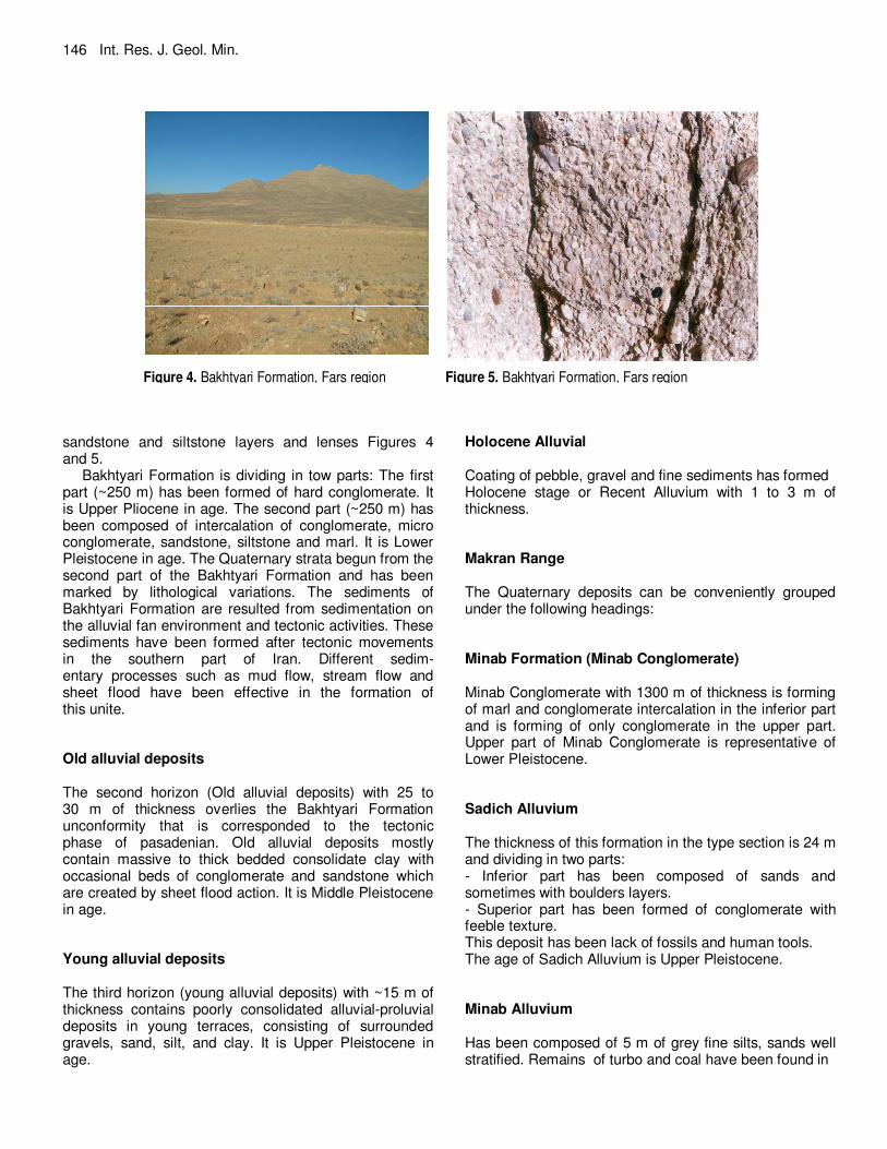
sandstone and siltstone layers and lenses Figures 4 and 5.
Bakhtyari Formation is dividing in tow parts: The first part (~250 m) has been formed of hard conglomerate. It is Upper Pliocene in age. The second part (~250 m) has been composed of intercalation of conglomerate, micro conglomerate, sandstone, siltstone and marl. It is Lower Pleistocene in age. The Quaternary strata begun from the second part of the Bakhtyari Formation and has been marked by lithological variations. The sediments of Bakhtyari Formation are resulted from sedimentation on the alluvial fan environment and tectonic activities. These sediments have been formed after tectonic movements in the southern part of Iran. Different sedim- entary processes such as mud flow, stream flow and sheet flood have been effective in the formation of this unite. Old alluvial deposits The second horizon (Old alluvial deposits) with 25 to 30 m of thickness overlies the Bakhtyari Formation unconformity that is corresponded to the tectonic phase of pasadenian. Old alluvial deposits mostly contain massive to thick bedded consolidate clay with occasional beds of conglomerate and sandstone which are created by sheet flood action. It is Middle Pleistocene in age. Young alluvial deposits The third horizon (young alluvial deposits) with ~15 m of thickness contains poorly consolidated alluvial-proluvial deposits in young terraces, consisting of surrounded gravels, sand, silt, and clay. It is Upper Pleistocene in age.
Holocene Alluvial Coating of pebble, gravel and fine sediments has formed Holocene stage or Recent Alluvium with 1 to 3 m of thickness. Makran Range The Quaternary deposits can be conveniently grouped under the following headings: Minab Formation (Minab Conglomerate) Minab Conglomerate with 1300 m of thickness is forming of marl and conglomerate intercalation in the inferior part and is forming of only conglomerate in the upper part. Upper part of Minab Conglomerate is representative of Lower Pleistocene. Sadich Alluvium The thickness of this formation in the type section is 24 m and dividing in two parts: - Inferior part has been composed of sands and sometimes with boulders layers. - Superior part has been formed of conglomerate with feeble texture. This deposit has been lack of fossils and human tools. The age of Sadich Alluvium is Upper Pleistocene. Minab Alluvium Has been composed of 5 m of grey fine silts, sands well stratified. Remains of turbo and coal have been found in
Figure 4. Bakhtyari Formation, Fars region
Figure 5. Bakhtyari Formation, Fars region

the interior of this alluvium, Using C14 indicated medium age of sedimentation of 1250 years. It is Holocene in age. CONCLUSION Beginning of Quaternary in the all parts of Iran was contemporaneous with tectonic phase of Late Walachian and Upper Pleistocene corresponding to tectonic phase of Pasadenian, which had contemporaneous influence on Iranian basin. These events produced many alluvial types of sediments, up filing mountains and covering valleys. In the Pliocene and Quaternary periods, the orogeny has been changed Iranian platform morphology and has been developed Alborz, Zagros, Makran and Kope-dagh ranges.
The sedimentary process has been effective in the formation of these alluviums, which created by alluvial, colluvial and proluvial actions. REFERENCES Djamali M, Soulié-Märsche I, Esu D, Gliozzi E, Okhravi (2006).
Palaeoenvironment of a Late Quaternary lacustrine–palustrine carbonate complex: Zarand Basin, Saveh, central Iran.Palaeogeography, Palaeoclimatology, Palaeoecology237, 315–334.
Fattahi M, Walker R, Hollingsworth J, Bahroudi A, Nazari H, Talebian M, Armitage S, Stokes S (2006). Holocene slip-rate on the Sabzevar thrust fault, NE Iran, determined using optically stimulated
Khaksar and Khaksar 147
luminescence (OSL) (2011). Earth and Planetary Science Letters 245, 673–684. Baku, Azerbaijan 203 Int. J. Academic Res. Vol. 3. No. 3. May, , I Part.
Kazancı N, Gulbabazadeh T, Leroy S, Ileri Ö (2004). Sedimentary and environmental characteristics of the Gilan–Mazenderan plain, northern Iran: influence of long- and short-term Caspian water level fluctuations on geomorphology. J. Marine Sys. 46, 145–168.
Kelts K, Shahrabi M (1986). Holocene sedimentology of hypersaline Lake Urmia, Northwestern Iran.Palaeogeography, Palaeoclimatology, Palaeoecology 54, 105–130.
Khaksar K, Rahmati M, Haghighi S (2011), Quaternary stratigraphy of northern Alborz range – Iran, Proceedings of the VII All - Russian Quaternary Conference “The Quaternary in all of its variety. Basic issues, results, and major trends of further research”, 12-17 September 2011.
Mary V, Heyvaert A, Baeteman C (2007). Holocene sedimentary evolution and palaeocoastlines of the Lower Khuzestan plain.Marine Geology 242, 83–108.
Nabavi MH (1976). An introduction to geology of Iran. (in Persian), Geological Survey of Iran, Tehran.
Pedrami M (1983). Plio–Pleistocene stratigraphy in Iran, prepared in cooperation with IGCP project 41; an internal report of the Geological Survey of Iran.
Pedrami M (1988). Quaternary geology and climatology of Arak area.Internal report of the Geological Survey of Iran, 3–11.
Pirazzoli PA, Reyss JL, Fontugne J, Haghipour M, Hilgers A, Kasper A, Nazari HU, Preusser F, Radtke U (2004). Quaternary coral-reef terraces from Kish and Qeshm Islands, Persian Gulf: new radiometric ages and tectonic implications. Quaternary International 120, 15–27.
Stoklin J (1968). Structural history and tectonics of Iran; a review. American Association of Petroleum Geologists Bulletin, 52(7):1229–1258.
Stoklin J (1977). Structural correlation of the Alpine ranges between Iran and central Asia. Mem. Hors-serie Soc. Geol. Fr., 8:333-353.