Embed Size (px)
Citation preview
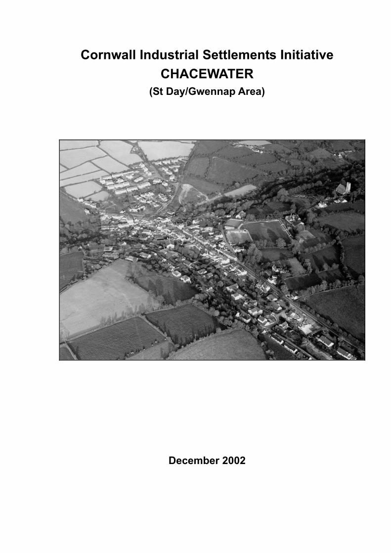
Cornwall Industrial Settlements Initiative CHACEWATER
(St Day/Gwennap Area)
December 2002

1
CORNWALL INDUSTRIAL SETTLEMENTS INITIATIVE Conservation Area Partnership
Name: Chacewater Study Area: St Day/Gwennap
Council: Carrick District Council NGR: SW 75 44
Location: Mid-west Cornwall, between Redruth and Truro on the B33298
Existing CA? Yes, designated 1991
Main period of industrial settlement growth:
1820s-30s Main industry:
Copper and tin mining; marketing and servicing
Industrial history and significance Inherent interest as part of one of the earliest and most significant mining areas in Cornwall; the growth of the 18th century copper industry here in particular was associated with innovation and the development of steam technology.
Chacewater is significant as an example of how the need to service a scattered mining population (here largely living in hamlets and smallholdings in the surrounding area) led to the creation of a deliberately planned and built service and market centre, fitted into an earlier, informally developed settlement.
Other comments This settlement will either form part of the proposed Cornish Mining World Heritage Site Bid, or will be considered an important part of the context for the Bid.
Recommendations Historic areas • Proposed alterations to the existing conservation area boundaries
• Prepare a full CA appraisal
• Article 4 Direction to control PD on single dwelling houses and alteration and partial demolition of small buildings in CA
• Article 4 Direction to control alteration and partial demolition of walls in CA Historic buildings • Review statutory list
• Prepare list of locally significant buildings Policy and management • Develop a co-ordinated policy for the conversion, restoration, retention and/or re-use of shops
and shop fronts in Chacewater
• Develop co-ordinated policy for the retention, recording and restoration of the historic leat system to its full extent
• Full survey of archaeological potential
2
• Recognise the importance to historic character of back-land areas and rear lanes
• Limit or restrict development on the outskirts, and particularly outside the development envelope
• Produce site-specific design guidance based on a detailed audit of materials, designs, details and character
• Undertake a fully integrated review of existing policies of traffic management
• Develop road improvement schemes and/or provision of street lighting and furniture that restore the sense of ‘street’ rather than ‘road’
• Develop a policy for landscaping treatment to address both hard and soft landscaping
• Undertake a full survey of existing trees and ornamental landscapes and implement appropriate protection measures
• Integrate and revise existing village trails and guides and other promotional initiatives and promote as a single package and develop partnerships
• Further study of the timing, scale and nature of smallholding development in the adjacent areas
3
Conservation Area Partnership
Cornwall Industrial Settlements Initiative CHACEWATER
(St Day/Gwennap area)
The Cahill Partnership and
Cornwall Archaeological Unit
December 2002
4
Acknowledgements This report presents the results of an assessment carried out by The Cahill Partnership following desktop research by Cornwall Archaeological Unit (Bryn Perry Tapper). Assistance was also provided by the conservation section at Carrick District Council. The report text was prepared by The Cahill Partnership and edited by Jeanette Ratcliffe (CAU CISI Project Manager). The report maps were produced by John Brinkhoff (CCC Technical Services Section) from roughs prepared by The Cahill Partnership.
Front cover illustration: Chacewater from the north-west; CAU F17/78/SW 750 445
©Cornwall County Council 2002 Cornwall Archaeological Unit, (Historic Environment Service), Planning, Transportation and Estates, Cornwall County Council, Kennall Building, Old County Hall, Station Road, Truro, Cornwall TR1 3AY. All rights reserved. No part of this document may be reproduced, stored in a retrieval system, or transmitted in any form or by any means without the prior permission of the publisher.
5
Contents Page
1 Introduction .................................................................................................................7 1.1 Background................................................................................................................................7 1.2 Project Aims ..............................................................................................................................7 1.3 Project methodology ................................................................................................................7 1.4 Date of assessment ...................................................................................................................7
2 Location and setting ....................................................................................................8 2.1 Geographical location ..............................................................................................................8 2.2 Landscape setting......................................................................................................................8
3 History and physical development (Fig 2) ..................................................................8 3.1 Pre-1809 .....................................................................................................................................8
3.1.1 Economic activity.................................................................................................................8 3.1.2 Extent of settlement.............................................................................................................8
3.2 1809-41 .......................................................................................................................................9 3.2.1 Economic activity.................................................................................................................9 3.2.2 Extent of settlement...........................................................................................................10
3.3 1841-1880.................................................................................................................................10 3.3.1 Economic activity...............................................................................................................11 3.3.2 Extent of settlement...........................................................................................................11
3.4 1880-1906.................................................................................................................................11 3.4.1 Economic activity...............................................................................................................11 3.4.2 Extent of settlement...........................................................................................................12
3.5 1906-1946.................................................................................................................................12 3.5.1 Economic activity...............................................................................................................12 3.5.2 Extent of settlement...........................................................................................................12
3.6 Post 1946..................................................................................................................................13 3.6.1 Economic activity...............................................................................................................13 3.6.2 Extent of settlement...........................................................................................................13
4 Current character (Figs 3 & 4) ................................................................................... 13 4.1 General .....................................................................................................................................13 4.2 Built environment ...................................................................................................................13
4.2.1 Streetscape and permeability.............................................................................................13 4.2.2 Public/ecclesiastical buildings ..........................................................................................14 4.2.3 Commercial buildings ........................................................................................................14 4.2.4 Housing................................................................................................................................15 4.2.5 Industrial remains ...............................................................................................................15 4.2.6 Paving/street ephemera.....................................................................................................16 4.2.7 Materials and local details..................................................................................................16
4.3 Views, vistas and green space................................................................................................17 4.3.1 Landscape setting and greenery........................................................................................17 4.3.2 Vistas and views..................................................................................................................17 4.3.3 Open spaces ........................................................................................................................17
5 Industrial significance................................................................................................ 18 6 Designations (Fig 4) .................................................................................................. 18
6.1 Scheduled monuments ...........................................................................................................18 6.2 Historic buildings....................................................................................................................18 6.3 Historic area designations ......................................................................................................19
6.3.1 Conservation areas .............................................................................................................19 6.3.2 Area of Great Historic Value............................................................................................19
6.4 Other designations..................................................................................................................19
6
7 Current issues and forces for change......................................................................... 19 8 Recommendations ..................................................................................................... 20
8.1 Historic areas .......................................................................................................................... 20 8.2 Historic buildings ................................................................................................................... 21 8.3 Policy and management......................................................................................................... 21
9 References .................................................................................................................. 23 9.1 Primary Sources...................................................................................................................... 23 9.2 Publications ............................................................................................................................. 24
Appendix: Gazetteer of archaeological sites and historic buildings................................. 25 List of figures 1. Location map
2. Historical development
3. Surviving historic components
4. Gazetteer sites, existing designations and recommendations
5. High Street/Fore Street – the planned market centre
6. Fore Street – shopfronts
7. Glimpses into the streetscape – Station Road and The Square
8. Riverside – intimate green corridors running through the village
9. Back lanes and countryside – East Bridge and The Terrace
10. Roofscape from The Terrace
Abbreviations in main text AGHV Area of Great Historic Value AGSV Area of Great Scientific Value AONB Area of Outstanding Natural Beauty CA Conservation Area CAU Cornwall Archaeological Unit (Historic Environment Service, CCC) CCC Cornwall County Council CISI Cornwall Industrial Settlements Initiative GPDO General Permitted Development Order HES Historic Environment Service, Cornwall County Council HERS Heritage Economic Regeneration Scheme (English Heritage) HLF Heritage Lottery Fund (ing) LB Listed Building OALS Open Areas of Local Significance to Settlement Character OS Ordnance Survey PD Permitted Development SPG Supplementary Planning Guidance THI Townscape Heritage Initiative (Heritage Lottery Fund) [1] Site number on Figure 4 and in the gazetteer (Appendix)
7
1 Introduction 1.1 Background Cornwall’s industrial settlements are the subject of a Conservation Area Partnership under the heading Cornwall Industrial Settlements Initiative (CISI). This partnership between English Heritage (with the Heritage Lottery Fund), Cornwall County Council, and the District Councils is intended to assess the character and significance of the County’s 112 industrial settlements. These include villages, ports and towns associated with Cornwall’s 19th century industrial revolution, based on metalliferous mining, slate and granite quarrying, and china clay extraction. The historic importance and distinctive character of such settlements has previously been undervalued, and their existing status does not adequately represent the industrial history of the county. CISI is aimed at redressing this imbalance.
The Cornish Mining World Heritage Site Bid is being prepared for submission to UNESCO by February 2004 (for inscription in June 2005). The bid areas will include the full range of 18th-20th century mining landscape components, including the settlements that were created or rapidly expanded as a result of mining and associated industries. All mining settlements are of significance to the World Heritage Site Bid - those that fall in the final Bid areas will be covered by the WHS Management Plan, while those that fall outside these areas will form part of the context for the World Heritage Site and will need to be sensitively managed in the light of this.
1.2 Project Aims The aim of CISI is to produce a settlement-by-settlement analysis in order to obtain an overview of the history, present character and importance of Cornwall’s industrial settlements. This will help determine where, for example, new Conservation Areas should be designated (and existing ones revised), and could provide the basis for Conservation Area Statements (to be drawn up subsequently by District Conservation Officers).
1.3 Project methodology The methodology involved historical research, followed by a site visit(s). For the historical research, a date range of 1750 to 1945 was chosen, as this represented the period of industrial growth and decline in Cornwall. Archaeological and historical sources housed at CCC (see Section 9.1) were consulted, together with Listed Building data supplied by the District Councils. Using this information, Ordnance Survey base maps were hand coloured to show: the different phases of historical development; surviving historic components from each development phase; archaeological sites, key historic buildings, and statutory designations. These maps (which formed the basis for Figures 2-4), together with copies of the primary sources consulted, were bound into a folder for each settlement, for use during site visits.
The focus of the site visits was to assess settlement character and consider ways in which this could be protected and enhanced in the future. This was achieved using a checklist drawn from Conservation Area Practice: English Heritage’s guidance on the management of Conservation Areas (1995) and Conservation Area Management - A Practical Guide (published by the English Towns Forum, 1998). The maps compiled during the historical phase were enhanced during the site visits, particularly with information relating to the survival and significance of historic buildings, and a general photographic record (colour prints) was made of each settlement. Meetings on site were arranged with the District Conservation Officers in order to discuss current initiatives and recommendations for future management.
1.4 Date of assessment Chacewater was assessed as part of CISI during Summer 2002
8
2 Location and setting 2.1 Geographical location Chacewater is located in mid-west Cornwall between Truro and Redruth on the B3298, in the parish of Chacewater (Fig 1). The B3298 was until the mid 20th century the principal road from Truro to Redruth and West Cornwall.
2.2 Landscape setting Chacewater sits just over the hill from the great mining area of the Poldice Valley. Yet this connection is hard to find today when the village sits tucked down in the well-wooded and secluded atmosphere of the upper Carnon Valley and its tributary valley that runs eastward towards Salem. This latter valley forms the principal axis of the village – following the line of the old turnpike road (Fore Street/High Street), which forms the spine of the settlement.
Immediately to both the north and south Chacewater is neighbour to the higher land of extensive mining waste dumps at Wheal Busy and Creegbrawse, but again the lush valley sides screen the physical connection.
3 History and physical development (Fig 2) This section should be read in conjunction with the mapped historical development in Figure 2.
3.1 Pre-1809 ‘I don’t know whether it be worthwhile to take notice of a place to the south of it (Kelly-freth) called Chace Water, which being on the great road between Truro and Redruth, and very near to the Great Works, hath now general
houses built on it.’ (Tonkin 1736, quoted in Acton 1997) 3.1.1 Economic activity The area in and around Chacewater was a focus of mining and tin-streaming activity from the earliest times. The ‘Great Works’ or Chasewater Mine (Wheal Busy) was active in the 16th century, was one of Cornwall’s major mines from at least 1718, first produced copper about 1724, and became the focus of early innovation in mining technology:
• 1725: Joseph Hornblower (whose family lived at Chacewater from the 1760s) erected some of the earliest Newcomen engines at Wheal Rose (Scorrier) and Wheal Busy. His son Jonathan became a leading engineer at Chacewater;
• 1775: Smeaton (of Eddystone Lighthouse fame) erected the most powerful engine then built in Cornwall at Wheal Busy;
• 1768: Great County Adit driven through Wheal Busy northwards to Wheal Peevor;
• most significantly, in 1778, Watt wrote to Boulton, ‘The Chacewater (Wheal Busy) engine is our capital card for, should it succeed in ‘forking’ this mine, all doubts will be removed’. This was the first Watt engine to be installed in a Cornish mine and, as such, it is of international significance.
From 1788 there was a temporary decline in copper production here as elsewhere in Cornwall because of the competition from the Parys Mountain mines in Anglesey, but there was rapid expansion in the 1800s when the Anglesey copper was worked out and the Napoleonic wars increased demand. 3.1.2 Extent of settlement Although with semi-legendary origins as a medieval, or even Arthurian hunting ground (‘chace’), more prosaically, Chacewater has been the property of the Boscawen family since 1335 when John de Boscawen married Joan of Tregothnan. The continuous ownership of the settlement
9
and most of the surrounding land and mineral rights by the Lords Falmouth throughout the industrial period had considerable consequences on the ways in which it developed.
Tonkin’s testimony points to a late 17th/early 18th century origin for Chacewater. It is absent on Norden’s detailed map of Kerrier Hundred (1597), but is shown on Gascoyne’s map of 1699 as a hamlet just to the north of the main road, with what appear to be some enclosures shown along the roadside itself. By the first relatively detailed evidence, the 1809 OS survey drawings, there is clearly a well-established centre, stretching east west along the main road more or less to its modern extent.
With tin streaming activity dominating the river valleys, most of what is now the centre of Chacewater remained free of building. The settlement formed a sort of elongated doughnut around this core; scattered buildings on both sides of the river in two separate parishes give the impression of an informally developing ‘squatter’ settlement. The 1791 British Directory noted that there was no market here, and the place was principally inhabited by tinners.
The earliest phase of settlement was along the tracks from Redruth and the Wheal Busy workings following the higher ground of the valley sides (The Terrace), to crossing points over the Carnon stream, or south down the valley itself (Falmouth Road). There were some small clusters of buildings along the main road and near the bridging point, but no continuous roadside development.
Beyond the main area of settlement, the earliest of a series of smallholdings had already started to be taken in from the large areas of open moorland to both the north (Wheal Busy) and south (Creegbrawse) of the village.
3.2 1809-41 ‘ its situation on the great thoroughfare between Redruth and Truro, with the advantages it derives from the mines, combine to render this little place one of some business and consequence’ (Pigot’s 1830 Directory of Cornwall). 3.2.1 Economic activity Mining was steadily expanding locally in the early 19th century and this had a major impact on the landscape around as well as the settlement. In 1818 700 people were employed on the Wheal Busy setts, 400 at Treskerby, although only 25 at Creegbrawse, which had seen its glory days in the previous century and was now in a decline from which it was not to recover. From 1826, Killifreth developed as a major copper producer.
The importance of the area is reflected in the name of the Redruth and Chasewater Railway set up in 1824, with the intention of linking the local mines to a new port at Devoran (although Chacewater never did receive its branch line).
As well as mining, there were elvan quarries at Creegbrawse in operation throughout the 19th century; although locally well known for the quality of the stone, this was only a minor local employer.
As the settlement grew, it clearly developed economic functions on its own account, particularly as a market and servicing centre for the surrounding industrial area, which gave it some independent economic role beyond being a purely industrial residential settlement. Pigot’s 1830 directory makes the point that it was the combination of its situation on the great road from Truro to Redruth and the west of Cornwall as much as the intensity of the surrounding mining industry which led to the development of the village.
10
3.2.2 Extent of settlement The 1841 Tithe Map shows that the village had not extended much beyond the bounds of the 1809 area. However, within that extent, there is evidence of re-building and restructuring and a change in the nature of the settlement.
Originally probably a rather ramshackle collection of squatters’ cottages, smallholdings and industrial buildings around the tin-stream workings and the river crossing, Chacewater had something of a rough frontier character. There were 13 pubs in Chacewater and fighting was evidently rife, to go by the comment of the West Briton in 1829, after a brawl outside the Britannia Arms: ‘It is high time that effective means were taken to preserve tranquillity in this village.’ The Tithe Map shows just how Chacewater was still shaped by the local topography and tin streaming activity at its heart. It was very much contained in the valley floor with the central area concentrated on the High Street and market area, while to the north and west there was a line of early 19th century smallholdings clearly related to the tin streaming works as well as the open moors on the hills around.
However, in the 1820s and the 1830s in particular, there was both informal change, and some clear elements of planned development within the village - along the main road regular rows of shops and houses were built, slotting into what had been roadside waste – a process probably associated with the straightening and improvement of the road itself (perhaps including the surviving bridge), and not yet complete by the time of the Tithe Map (1841). A completely new market house and yard were constructed, while the church was built in 1828 to the south of the village (suggesting that there was no land in the village centre for such an ambitious project, whether because of the tin-streaming works or because land was needed for Chacewater’s growing importance as a market centre). The church was designed for 1500 people; by 1837 Chacewater had grown sufficiently that to become a separate parish from its mother parishes of Kenwyn and Kea.
The two principal chapels both date from the same period (on Chacewater Hill, dated 1830, and in Station Road, rebuilt 1860s), and not only give further pointers as to what was probably the key period of settlement development - the 1820s and 1830s - but also reflect developing stability in the social and economic character of the village. It was being added to and ‘gentrified’, especially by the locally prominent Harvey and Moyle families. As a result of the wealth being generated from Wheal Busy, Samuel Harvey (the mine’s assayer, unrelated to the Harveys of Hayle) built The Terrace on land leased from Lord Falmouth; the Harveys also built Buckingham House (now The Latchetts & Little Latchetts).
While contemporary records (church registers for instance) show miners living in Chacewater, contemporary trade directories suggest that most of the inhabitants were not actually miners as such, but earned their living from managing (mine agents, managers, assayers and pursers), marketing and servicing the surrounding mining industry (publicans, smiths, bootmakers, grocers and drapers etc.) – even the rows of ‘industrial’ cottages along Station Road may be linked to the large brewery that was already well established in Chacewater in the 1830s rather than directly to mining. The intensely settled surrounding landscape may well have provided most of the working population for the mines – in 1851, for instance, Creegbrawse’s population was 866.
3.3 1841-1880 ‘When the mines were in their palmy days, Chacewater was a place of considerable importance as a mining village; a capital market-house was built for the convenience of the people, but has since been almost deserted…..Scarcely a
family is to be found one member at least of whom has not been out either to Mexico, California, Brazil, New Zealand, Australia, Africa, Spain, or some mining district of less account.’
Henwood, late 1850s (quoted in Acton 1990).
11
3.3.1 Economic activity By the 1850s, the first signs of the long-term decline of mining around Chacewater were becoming clear. The opening of the West Cornwall Railway in 1852, running less than half a mile north of Chacewater and on the northern edge of the Wheal Busy sett, was clearly not enough to save the ailing mines. Despite production of copper ore at Wheal Busy reaching an all time high in 1861 of over 6000 tons, worth nearly £19000, Henwood’s testimony makes it clear that the Chacewater area was already suffering from decline; by 1867, only 99 tons were produced at Wheal Busy, returning £158. It was a similar story for tin, from about 1860 a major product at Wheal Busy, Killifreth and some other local mines. Although the tin market rallied weakly in the 1870s, it never fully recovered locally to the rewarding levels of 1865. Wheal Busy was finally abandoned in 1873, only months after a huge capital investment programme.
Emigration was not only overseas - in 1867, a representative of the Earl of Durham attended the National School-room for ‘engaging men and boys for His Lordship’s collieries’. Many signed up on a one-year renewable contract at Little Town collieries near Durham.
Despite Henwood’s comments about the state of the market at Chacewater, it continued to be mentioned in trade directories throughout the late 19th century, while the brewery continued to be an important employer throughout the period. 3.3.2 Extent of settlement
‘well built colour-washed cottages.... bow-windowed Georgian shops.... and up the valley slopes the tidy villas built in the last century by tin mine captains.’
Sir John Betjeman, writing in the 1960s; quoted in Acton 1997, 155).
The 1880 OS map shows Chacewater on the edge of a much reduced mining area, particularly to the south where Creegbrawse, which once was only a field away from encroaching on the village centre, had shrunk back to tiny proportions, its waste dumps reclaimed for agriculture. Creegbrawse’s population, 866 in 1851, fell to 535 by 1881. The small amount of new building in Chacewater reflected the continuing growth in population and wealth up to the 1860s, with little built after the collapse of the local mining industry:
• 1847: erection of village school, Church Hill.
• 1852 main line railway and station opened
• 1860s: re-construction of chapel in Station Road.
• 1870: the Harveys built Exmouth House in The Terrace (so named because of the family’s connection with Sir Edward Pellew, hero of the Napoleonic Wars and Earl of Exmouth).
Chacewater had become a favoured residential area for a number of professional and private residents – especially those who had advance from mining, brewing, and service industries into the ranks of ‘gentility’, while, by 1881, trade directories show a marked decline in the number of craft trades in the village (smithying etc.), and a greater trend towards simple shop keeping of the butcher, baker and grocery type.
3.4 1880-1906 3.4.1 Economic activity The local mines continued to decline - Killifreth mine carried on relatively active until it closed in 1897 after a dispute between owners and shareholders; there is little evidence that any other major economic activity or employer took their place, apart from temporary works, such as when, in 1888, the Chacewater viaduct was rebuilt. Although statistics are not forthcoming, the
12
market, shop keeping, brewing and service role which was the mainstay of economic activity within Chacewater itself must inevitably have suffered during this period.
The surrounding area became more notable for market gardening and fruit production – which had become increasingly economically viable after the creation of the through-line from west Cornwall to Plymouth and London in 1859 - and became known for its Long Stem apple and its gardens, a sign if ever there was one that its industrial glory days were over.
The railway station saw further development in 1903, when it became part of a new holiday line (officially the Truro and Newquay Railway), which increased passenger numbers (and led to a newsagents and bookshop business being established at the railway station). 3.4.2 Extent of settlement Given the lack of employment opportunities it is not surprising that the parish population fell from 3558 in 1881 to 2053 in 1891. The two significant building projects in the village relate to public munificence and not demand from an increasing population:
• In 1892 the church was almost completely remodelled. Significantly, the new church seated a reduced number of 500 people, reflecting the continued decline in local population.
• 1893: Passmore Edwards Literary Institute donated by John Passmore Edwards, but perhaps of more personal significance here as he was a native of nearby Blackwater.
3.5 1906-1946 3.5.1 Economic activity The early 20th century saw a significant revival in the local mining industry:
• In 1907 Wheal Busy re-opened primarily for arsenic production for the Anglo-Belgian Company. The celebrations were such that Lord Falmouth gave a whole bullock to roast for the party. Arsenic was roasted on site until World War II; shortly after this the engine was broken up for scrap.
• Killifreth Mine re-opened in 1911. Arsenic was produced here too and the Killifreth Company owned Wheal Busy in the mid-1920s; in the end Killifreth also failed and the plant was broken up for scrap in World War II.
Apart from the brewery, which continued into the early/mid 20th century, agriculture continued to be as important, if not more so, to the economy of the village; as well as the continuing market, the annual Chacewater horse and cattle show was one of the largest and most popular in Cornwall according to contemporary trade directories. 3.5.2 Extent of settlement The re-emergence of mining had little effect on population size in Chacewater and there was, unsurprisingly, little development during this period, with only the recreation ground, donated by Lord Falmouth and the Harvey family in 1925, and a pair of houses in the High Street. However, there may have been some stimulation of economic activity (a number of buildings in the village, including shops and public houses, show signs of re-modelling and expansion in the early 20th century).
The social make-up revealed by trade directories shows a high proportion of ‘private residents’ (35 in 1906), the biggest single economic group locally were farmers, and the range of shops and trades was much more typical of an agricultural market centre than an industrial village.
13
3.6 Post 1946 3.6.1 Economic activity Chacewater has become very much a dormitory settlement servicing Truro and, as such, has little or no industrial base of its own. Even the Saturday market and the annual fair/show have now ceased. The High Street shops provide some employment and the village has developed a small specialist market. The railway station closed in 1964, sealing Chacewater’s fate as an economic backwater. 3.6.2 Extent of settlement The slopes of the valley below The Terrace have been developed with detached housing and some flats. Elsewhere, the village has expanded to the east and south-east in the form of modestly sized housing estates, although the often large, detached, houses on them to some degree perpetuate the middle-class character of late 19th/early 20th century Chacewater.
4 Current character (Figs 3 & 4) 4.1 General The church, vicarage and National school (i.e. Church of England sponsored) are at a distance from the village centre and on the opposite side from the typical industrial institutions of chapels, Institute, Masonic Lodge and much of the workers’ housing. This is perhaps more than a coincidence, and is certainly symbolic of the two divergent influences in the development of Chacewater – the ‘organic’ industrial settlement, and the formal, planned market town sponsored by the Tregothnan Estate.
In general, the quality of both built and natural environment in and around Chacewater is good, with a high proportion of listed buildings and many others of interest, set in a gently decaying industrial landscape, marked by the sound of running water through the old leats in an increasingly well-wooded valley.
Indeed, although the relatively short and contained ‘urban’ stretch of Fore Street/High Street is the part of the village most often seen from vehicles passing through, once off this main road Chacewater is overwhelmingly characterised by its sheer quantity of trees, overgrown hedges, rough verges, mature gardens, informal and semi-rural stream banks and a direct visual and physical link with the surrounding countryside.
However, the impact of traffic noise and fumes on this otherwise idyllic scene can be hugely detrimental. Chacewater is unfortunate in being well positioned as a short cut between the A30 and the A390; as such, Fore Street is often uncomfortable and at times unsafe for the pedestrian, and noise, fumes and parking problems permeate much of the rest of the village.
4.2 Built environment 4.2.1 Streetscape and permeability The setting of the village within two relatively deep and narrow valleys allows for a great quality and scale of outlook in the outer, upper streets, and provides for an important roofscape throughout the village; there is a contrast between these informal, entirely residential outer streets and the busy, tight, almost urban scale and grain of the main roads. The two areas were historically separated by the continuing presence of the streams, leats, tin streaming, walled gardens and back-land areas which have today to some extent been developed and infilled, but there remains an almost immediate transition from busy street-frontage to back street throughout Chacewater which is one of its most distinctive features.
This contrast is made all the more apparent because the buildings along the main road were largely built as part of a single planned phase of development, with an overall similarity in scale, material, detailing and function (urban rather than ‘village’ in character). They were fitted into an
14
older settlement morphology and therefore have in many cases virtually no rear yards. Fore Street is a small, planned, regular element in an otherwise spreading, somewhat amorphous and organic settlement structure.
Another consequence of this is that most of the public buildings in Chacewater do not stand along this main frontage – the chapels and market are just set back from the frontage, the school and church are at some distance, the railway station even further out; only the Passmore Edwards Institute is on Fore Street, and that is a late insertion.
The corollary of this, then, is that Chacewater is very different seen, as most often it is, from the inside of a car passing through, compared to a pedestrian walk around. The historic settlement spreads along the valleys and up the hills, fortunately contained by an overall intimacy of scale, and linked by an unrivalled network of paths, alleys, lanes; once away from the main road (in itself good quality townscape) a different Chacewater reveals itself, and something of the qualities that attracted so many professional and private residents in the 19th century are revealed. 4.2.2 Public/ecclesiastical buildings The church [54], originally designed by Charles Hutchens and extensively rebuilt by Edmund H Sedding, loftily stands apart from the village, separated by fields and a short steep hill. There is a delightful sense of seclusion here only five minutes from Fore Street. One of the younger Sedding’s best ecclesiastical achievements (Betjeman comments: ‘A satisfying sense that Sedding, here, knew what effect he wanted to get, and got it.’), its setting is uncompromised and an important foil to the village below.
The nearby school [52] is a particularly neat example of Victorian Tudor style school architecture in a wonderfully secluded setting on the hill towards the church, surrounded by open ground.
The older of the two surviving chapels [79] (conveniently dated 1830 on the front) is now used as workshops, a use that has led to its forecourt being affected by parking, although it is otherwise in reasonable condition on the outside. The second chapel in Station Road [100] appears to have a more complicated history and may well incorporate fragments of an earlier 1830s meeting house in its more grandiose mid-late 19th century frame. Both dominate their immediate surroundings, giving a sense of scale and strong historical character to what might otherwise be rather downgraded roadside areas, the roof of the Station Road chapel with its banded slates, is one of the most prominent features of the conservation area views into it.
The Passmore Edwards’ Literary Institute [26] of 1893 is one of the few buildings in Chacewater from this late Victorian period and makes a strong statement in the street scene. Its close neighbour, the later 19th century Masonic Hall [28], attached to the rear of the much earlier Britannia Inn [25], is also of interest. 4.2.3 Commercial buildings The market [61] probably dates from about 1830, although it first makes its appearance on the tithe map of 1841; it was part of the measured expansion of Chacewater at this time into the valley bottom. The present structure is largely a 20th century rebuild, but is of interest both architecturally and in terms of its historical function, as a hub of the village’s commercial life. It is appropriate that it currently has a commercial use.
Fore Street is remarkable for the amount of good surviving shop fronts [20][24][27][33][38][40] [41][42][43][47], many of which are part of listed buildings. They exhibit a good range of dates and detail, although they are almost entirely of timber construction, and do exhibit some general characteristics – especially the use of curved transoms and projecting bays. Although many are now converted to residential use, there has been very limited loss of shop fronts as a whole, of their historic detail, of instances of conversion to double-glazed or domestic-style windows,
15
despite being located on a busy road. This is in marked contrast to some similar shop fronts in nearby St Day. This must be a function of their being listed and therefore protected, and a study in the contrasting fortunes of two apparently similar settlements could provide useful data and design guidance for the widespread problem of retention of historic shop fronts throughout the county.
Public houses are still well represented, from the once infamous Britannia Inn [25] and The Rambling Miner [16] to the interesting (but strangely unlisted) King’s Head [63]. These hostelries are as equally important for their historical significance – recording Chacewater’s role as a miners’ settlement and market, and a resting place along a major turnpike road – as for their interesting architectural detail. The survival of their outbuildings – for example the now-demolished stables (themselves perhaps converted from an earlier alternative use) to the King’s Head [69]– adds depth to the historic fabric in the village. 4.2.4 Housing The earliest cottages are those on the outer edges of Chacewater which tell of its history as a mining/smallholding settlement; examples to the south-east [74] and to the west [103] are set between the tin streaming valley floor and mine waste dumps; others, now in a sad state of dereliction [96][97], are on the route to Wheal Busy – historic map evidence indicates that there were yet others scattered around the valley sides that are now lost.
Rows of workers’ cottages are well represented in Chacewater [80][83] (Station Road has one of the longest and most interesting [89]) - all date from the early/mid 19th century boom years.
The expansion of the village in the peak period of the early/mid 19th century also led to some more genteel architecture. This is most evident in The Terrace, where the Harveys created large detached houses [102] from old cottages, or built from new, set in their own grounds with magnificent views across the valley towards Creegbrawse, the church and the Carnon Valley. Other large houses in the village, which point to its dominant middle class character in the 19th century, include the stuccoed villas overlooking Station Road [95][94], 18 Chacewater Hill [85] with its mature gardens, the listed ‘Woodside’ [13] set in its own extensive grounds and the grand former vicarage, Chacewater House [55]. 4.2.5 Industrial remains Chacewater was largely a service centre for the surrounding industrial areas, rather than a location for heavy industry itself. However, the two valleys in which it sits were extensively worked for tin streaming from the earliest times until at least the mid 19th century, and as sources of power for milling. The most obvious and all pervasive industrial remnant now is that of running water – the river and leats [114] running through the village, although sadly overgrown and not functioning in places. The leats follow roughly the same courses as the streams first shown on early 19th century mapping, but they have often been straightened, re-aligned, lined with stone and, more recently, concrete, bridged and culverted. The dating and sequence of all these changes is not apparent from current knowledge, nor from a cursory site investigation, and requires much fuller research. Other features associated with the watercourses are the several bridges of varying dates and scale (itemised with the leats on the gazetteer), the listed bridge [70] and the listed wash place [72]. There may be considerable archaeological potential along the leats and streams for evidence of tin-streaming, processing, milling and other water-related activities, for instance those associated with the brewery site [87].
Although the village is surrounded by mile upon mile of mining waste and is only hundreds of yards from one of the most important mines in Cornish if not national history, the steep valley sides and heavy tree growth have screened all this from the village itself. With the valley floor now largely built on, it is hard to imagine the scale of works that must have gone on here. There were several recorded stamping mills and flourmills in the valley floor, all now apparently
16
demolished. One possible 18th/19th century mill complex [69] immediately adjoining the listed bridge [70] survived until 2002; the buildings were demolished, unrecorded, during the production period of this report.
Chacewater’s other major industrial site, also reflecting its waterside location, is that of the Brewery [87], now sadly reduced to a remnant of boundary wall [88], the site having been developed for housing without benefit of any recording or archaeological investigation.
Little of interest survives at the railway station, apart from the layout of former sidings; the present building (not used in association with the railway) is a 1950s replacement of the former station buildings. 4.2.6 Paving/street ephemera There is a limited amount of surviving original paving, which is of interest and provides wonderful texture – examples include the paving outside the market [68], cobbling outside no. 2 The Square [64], the flush curved granite doorstep [30] to no. 1 Fore Street, as well as granite kerbs to the pavements; some of the rough paved surfaces of the tracks leading away from the village centre may represent original 19th century or earlier surfacing [113].
Another local characteristic is the number of standing granite stones and posts through the village, whether post and rail fences along the roads such as adjacent to the car park [67] and to the rear of Riverside [92], boundary stones [1] or the listed milestone [22].
Walls are tremendously important to Chacewater’s character and range from those between front gardens [80] to the remnants of the Great Walled Garden [6][7], giving a strong boundary line along the highway and back lanes. The Great Walled Garden, indeed, remains one of the most significant elements of the morphology and structure of the village, fortunately having been used as a boundary to infill development in its area, and still framing both main road and back lanes. Its age, history and use remain something of an enigma. 4.2.7 Materials and local details Chacewater is not a granite-built settlement; the predominant stone is the local brownish killas, laid as random rubble, or sometimes roughly squared and coursed, typically with brick dressings for lintels, arched door and window heads and stacks (especially the early 19th century buildings in the centre). Brick rarely appears as the main building material (the late 19th century pair in The Square [60] is a notable and interesting exception). Later 19th century buildings use more dressed granite for lintels, cills, quoins etc. Many of the mid 19th century buildings and shops along Fore Street make extensive use of stucco and other moulded and enriched composition materials (including rare imitation wood effects associated with some of the shopfronts). There is, indeed, something of a paradox that many buildings throughout Chacewater are now either rendered over, or painted, which were originally and, more appropriately, left with exposed stonework, while other buildings, especially in the centre, show signs of stuccoed facades having been inappropriately stripped to reveal the underlying stone face. Much subtlety in both the artistic and historical character of the village is thus eroded.
Local elvan from Creegbrawse is used in the church, and ascertaining the extent and date of its use in the village could be a useful piece of research.
Roofing was throughout of natural slate, and although much has now been replaced, most damagingly along the main road, the views over the centre and of the rear elevations of the core area actually reveals much surviving around the village. There are scattered individual examples of the use of slate hanging, only occasionally for a main elevation, but it is not a particular local feature or tradition.
17
It is not surprising, given the quality of surviving shop fronts, that high quality timber joinery is a noticeable feature in Chacewater – it also appears on many of the domestic and other buildings in the village.
4.3 Views, vistas and green space 4.3.1 Landscape setting and greenery The importance of trees to Chacewater’s character cannot be overstated; they form the setting of the village and permeate nearly every street. They dominate all the views in and out of the village and serve to screen its outer streets from the often noisy and unpleasant traffic environment of the centre. The greenery is to be found in hedgerows; in the surprisingly large, and very important, garden areas; along the undeveloped stream banks and in public open spaces (the recreation ground etc.).
From the higher streets, the roofscape is set in a wooded landscape, and within the streets, the glimpses into the overgrown land at the heart of both valleys is one of the most singular aspects of the character of the village, notwithstanding the tendency in the late 20th century to view these highly picturesque, secluded and often enchanting places merely as derelict land suitable for all-too-often inappropriate development.
Chacewater has a unique quality of the countryside being immediately accessible from the hard, traffic-filled core of the settlement. Roads and footpaths, often intimately secluded, lead directly into quiet, hedgerow dominated countryside. These roads and paths are often historic tracks to the old mine sites, and of great historic interest in themselves, and usually are rough–paved and suitably informally edged, an important part of their attraction. New developments (as to the south of the village) have tended to interrupt this enclosed feeling, which could be maintained or restored with sensitive landscaping.
The mature ornamental planting and hedgerows in the valleys is a contrast to the more open farmland, and the scrubby moorland and mine waste beyond that, which surrounds the settlement. 4.3.2 Vistas and views The church is highly visible in the long views down the valley from both the A30 and the railway. There are views up and down Fore Street/High Street, which demonstrate the historic development of the central core; within these streets it is the chapels (especially the large chapel in Station road [100]) which form the focal points of intermediate views. From The Terrace there are wonderful views across to the church and also down on to the rooftops, which are mostly in original slate in the historic core, giving important texture to the village.
Within the village there are many intimate views of townscape value. For instance, the walk up Riverside along the leat is particularly delightful, with glimpses of houses through the trees. This is a particularly intimate series of spaces, which gives interest to the eye. By the same token there are numerous glimpses back into the ‘urban’ core of the settlement, often focusing on extremely well-detailed and important historic buildings. These glimpses reinforce the sense of the organic overlain by the planned which is an essential part of the settlement history of Chacewater. 4.3.3 Open spaces Chacewater has made good use of its open spaces in the name of community enjoyment; the recreation ground [50] and the more recent Millennium Park across the road play vital roles in the village. These areas are on the edge of the settlement; appropriately treated open spaces within the ‘urban’ core are harder to find; even the rough ground on the lower valley sides has been developed. The main car park remains a scruffy tarmac area, former gardens and enclosed grounds to the rear of the main streets have little sense of quality or place (for instance on the east side of Station Road) while potential urban spaces, as in The Square, or around the Chapel
18
lack definition, or a fixed identity within the wider streetscape. This makes it all the more important to retain the sense of the rural landscape coming up to the village centre.
5 Industrial significance Chacewater’s relationship with Wheal Busy places it at the heart of early mining innovation; the early Newcomen and Watt engines tested there were to have a huge impact around the world. Sandwiched between Wheal Busy and Creegbrawse, Chacewater’s early significance was connected with tin streaming; then, as Wheal Busy became even more significant, the village assumed a connected accommodation and market function. Its position on the main Redruth-Truro road was clearly one of the main factors in its growth, and helped to sustain it after mining had declined.
Herein lies its significance; although tin streaming seems to have continued into the 19th century, and a relatively large brewery had developed by the 1830s, it was ‘industrial’ not in the sense that industrial activity took place here (unlike Redruth), nor even that it housed large numbers of miners (as did Camborne), but it was largely a market and service centre (as with St Day, for instance). It also found particular favour as a residential area for senior managers and other ‘private residents’. Its sheltered position, hidden from the mines themselves, no doubt accounted in large measure for that.
As a settlement in itself, it has significance as one of those places where some element of planning and control can be seen on the ground, although as yet insufficient research has been done to trace the development in the written records. The role of the Boscawen family interest (The Tregothnan Estate) may well turn out to be crucial – as the principal landowner it must have had some role in the laying out of Fore Street, the creation of a purpose-built market and the improvement of the roads on which this development took place.
Chacewater is significant in the way that the surviving settlement morphology and built fabric reveals this deliberate layering of, in effect, a new town over an older, organic settlement – in this sense, it is no less a planned settlement (although on an even smaller scale) than the better-known mineral ports of Cornwall. The location of church, vicarage and National school on one side of the valley, seemingly in opposition to the chapels, Institute, Masonic Lodge and much of the workers’ housing on the other, is symbolic of these two divergent influences– the ‘organic’ industrial settlement, and the formal, planned market town.
Chacewater is one of a number of industrial and market settlements in Cornwall that stand partway between being villages and ‘proper’ towns. There is a clear attempt at urban scale and character in the core, which included in its conception a relatively grand market complex. Many historic boroughs and towns in the county were little bigger, and indeed sometimes smaller, than Chacewater in its mid 19th century heyday, but its dependence upon the strength of the local mining industry ensured that when that industry stagnated and declined, Chacewater would never in itself continue to progress to a truly urban character.
6 Designations (Fig 4) (All policy numbers refer to the Carrick District Wide Local Plan adopted April 1998)
6.1 Scheduled monuments There are no scheduled monuments in the study area.
6.2 Historic buildings There are 34 listed buildings in Chacewater, all of which are listed Grade II.
19
6.3 Historic area designations 6.3.1 Conservation areas A conservation area was designated in 1991 and covers the heart of Chacewater, but excludes The Terrace to the north and The Great Walled Garden to the west. 6.3.2 Area of Great Historic Value An AGHV (Policy 4Y) touches and lies to the west of Chacewater, covering the large mining area of Wheal Busy and Creegbrawse and, further afield, United Downs and the Poldice Valley.
6.4 Other designations The recreation ground has been designated as Protected Open Space (Policy 10D).
Chacewater School and its playing field have been designated as Educational Land (Policies 12A & 12B).
7 Current issues and forces for change There is some pressure for new build on the south-east side of the village within the development envelope, and this is being constructed at the time of writing. There is very little other available land in Chacewater, opportunity sites are few, and further development can only compromise the interest and setting of the village’s historic character, particularly as it would be likely to require the loss of important and historic ornamental and garden space (the grounds of Woodside [13] have recently been considered for housing provision) or the demolition of existing historic buildings - for instance, the very interesting former mill/outbuildings [69] in Fore Street were demolished, with planning permission for redevelopment, at the time of writing this report.
This affects not only structures, but also areas of great historic and archaeological importance which should at least be studied, investigated and recorded before redevelopment as in the areas along the valley floors, around the Great Walled Garden and in the area yards and alleys of the main streets. Development in these areas also has potential to change the distinct contrast between the hard streetscape of the built-up core, and the softer, quieter, less densely packed, greener, more informal outer streets – issues of scale, materials, form and enclosure are important in this context.
Some other important historic buildings in the village have recently been ‘at risk’, either through structural failure (the recently repaired and restored no. 2 The Square for instance), or because of declining use – the Literary Institute has only recently secured a future through conversion to residential use, while the unlisted Methodist Chapel [100] in Station Road has had applications for demolition and replacement by a smaller structure refused, but the issue of declining congregation numbers and expense of maintenance remains critical.
This reflects to some extent the lack of full appreciation of the worth of many of the historic structures in Chacewater. In such a relatively small settlement and with an unusually large number of listed buildings, there is always a temptation to view those that are not listed as of less significance, rather than simply as not meeting a specific set of criteria such as listing requires. Other small outbuildings, and particularly walls, which are so much a feature of the distinctive local historic character, also show signs of neglect, decay and lack of recognition of their true interest.
As with so many other settlements in the study, the greatest threat is from incremental change, whether it is replacing roofs with modern materials of an inferior quality or replacement uPVC windows. In terms of the justification for such change (due largely to the need to reduce traffic noise and fumes), it is an interesting feature of Chacewater that along Fore Street, where most change would be expected, listed buildings are concentrated and alterations as a consequence not
20
as prevalent as they might otherwise be. The incidence of replacement is, therefore, greater in the quieter outlying areas of the village (or on the outer reaches of the main road, where fewer buildings are listed), in both cases less justifiable in terms of the perceived problems.
The third, but by no means least important threat, is this of traffic. At rush hour Chacewater is a busy rat run, a short cut between the A30 and A390 for commuters to and from Truro. The approaches, both east and west, into the village do not encourage traffic to slow to an appropriate speed with the result that there is inevitably some speeding through the main street and much disruption to the historic environment as a result of noise and fumes. While parking is allowed along the main road, and performs a valuable function in traffic calming, there is pressure in the tightly packed streets and lanes around the village for parking spaces, inevitably placing pressure on existing gardens and yards for hard standing, and, perhaps more damaging, leading to a loss of a sense of enclosure in many of the newer developments in and around the village (for instance in the area of the Great Walled Garden) as they are forced to meet required parking provisions.
Some recent improvements in the streetscape have been achieved by the partial under grounding of some power cables and removal of redundant timber posts along Fore Street and High Street. Much more remains to be done by other commercial and statutory operators.
With current re-appraisal of the rail network, and proposals throughout the country to re-open small stations, or establish new ones, it may be apposite to review the practicality of re-establishing Chacewater Station on the main line, the site of which is still accessible from the village. This could be timely in the light of continued growth of the village as a commuting outpost of Truro (and to a lesser extent Redruth), also on the main line.
Chacewater has a good range of commercial and community facilities, better indeed than many settlements of its size, which helps to preserve a positive sense of local identity despite the pressures of commuter-type development.
8 Recommendations 8.1 Historic areas
Recommendation 1: Conservation area extension
It is recommended that the conservation area be extended northwards to include The Terrace and North Hill; westwards to include the Great Walled Garden and as far as the sett boundary stone [1] which marks the end of the historic village, and southwards to include the church. Suggested boundaries are shown in Figure 4.
Reason: To recognise the full extent of the areas of special architectural and historic importance in Chacewater, and to promote policies and schemes for the preservation and enhancement of those areas. Recommendation 2: Conservation area appraisal
Prepare a full and detailed conservation area appraisal to accompany CA designation/extension, which will subsequently guide proposals for the area’s preservation and enhancement.
Reason: To accord with statutory requirements and departmental policy advice, to ensure a full and adequate understanding of the special historic and architectural importance of the CA, the range of historic fabric and archaeological potential, and to establish effective parameters for management and policy proposals.
The integrity of Chacewater’s historic character is at risk, from incremental changes; Article 4 Directions to control the erosion of this character through the loss of, for example, roof materials, original window patterns and boundary walls are strongly recommended.
21
Recommendation 3: Article 4 directions (walls)
Article 4 Directions to control the demolition of walls and hedges, especially for the creation of hard standings.
Reason: To protect the character of Chacewater against inappropriate incremental alterations and demolition. Recommendation 4: Article 4 directions (buildings)
Article 4 Directions to control demolition and alterations to individual houses, to prevent the loss of such features as unlisted shop fronts, especially when now in residential use, and to prevent demolition of free-standing outbuildings.
Reason: To protect the character of Chacewater against inappropriate incremental alterations and demolition.
8.2 Historic buildings Although with an unusually large list for a relatively small settlement, and only recently reviewed, there are certain inconsistencies which might be addressed, particularly in the listing of some of the outlying early cottages and workers’ housing/smallholdings [3][74][110][111], which appear to be identical in date and degree of survival to others that are currently listed. Also worth review are some of the early-mid 19th century middle class houses, associated in many cases with identifiable local figures of some interest (like the Harvey family) [55][102][81][95]. An individual structure of note, which may already be protected by virtue of its relationship to the Britannia Hotel, but which merits individual listing, is the Masonic Hall [28]. Finally, some of the walls and other structures may be worth further consideration – in particular the Great Walled Garden [6][7].
Recommendation 5: Statutory listed building review
Review the statutory list of buildings of special architectural or historic interest.
Reason: To update the statutory list to reflect changes in understanding of the historic environment, in order to preserve or enhance the special character of the buildings and the area. Recommendation 6: Non-statutory historic buildings survey (local list)
Prepare a list of locally significant structures which contribute substantially to the character of the settlement, based on the combined criteria of both listing and Article 4 Directions, and backed up by a Buildings-at-Risk survey, detailed Article 4 Directions and substantive and enforceable policies in the local plan. This could also back up applications for grant aid.
Reason: To ensure a full and accurate record of the historic fabric of the settlement, to strengthen existing Local Plan commitments to prevent proposals that would harm the historic heritage of the village and guide development and promote change that will preserve and enhance the character of the village.
8.3 Policy and management Recommendation 7: Shops and shop fronts strategy
Develop a co-ordinated policy for the conversion, restoration, retention and/or re-use of shops and shop fronts in Chacewater (including design guidance), coupled with an extensive program of shop front restoration and/or improvement.
Reason: To preserve and enhance this most important element of the special character and appearance of the conservation area, enrich the character of the existing townscape, and act as a catalyst for drawing down regeneration grants from schemes such as English
22
Heritage’s Heritage Economic Regeneration Scheme (HERS) or the Heritage Lottery Fund’s Townscape Heritage Initiative (THI). Recommendation 8: The leats
Develop a co-ordinated policy for the retention, recording and restoration of the historic leat system to its full extent.
Reason: To enhance the character of Chacewater by restoring an important surviving element of its industrial past. Recommendation 9: Archaeology
Undertake a full survey of archaeological potential in Chacewater to give weight to Policy 4T of the Local Plan, ensuring that proper recording of archaeologically sensitive sites is carried out before development commences (the demolition of the brewery [87] and fine outbuildings [69] by the bridge without any recording points to the need for such a survey).
Reason: To comply with and strengthen existing Local Plan commitments to prevent proposals that would harm the archaeological heritage of the village and mining remains in general, and thereby preserve the special character of Chacewater. Recommendation 10: Back-lands and rear lanes
Recognise the importance to historic character of back-land areas and rear lanes of Chacewater, enhance their informal qualities, at the same time preserve the important buildings that survive.
Reason: To preserve and enhance the special character of Chacewater, especially in areas unlikely to attract private investment and attention. Recommendation 11: Limit or restrict development
Limit or restrict development on the outskirts of Chacewater, and particularly outside the development envelope.
Reason: To retain both the discrete identity of Chacewater and the historic interest of its mining remains. Recommendation 12: Design guidance
Produce site-specific design guidance based on a detailed audit of materials, designs, details and character, both of standing buildings and of street paving materials. Separate guidance is required for shop fronts.
Reason: In order to build on the expertise already demonstrated, and guidance on general principles already produced, and to preserve and enhance the special character of Chacewater, and promote change that will preserve and enhance the character of the village. Recommendation 13: Traffic calming
Undertake a fully integrated review of existing policies of traffic management, investigating existing traffic calming measures; prepare landscaping schemes appropriate to historic character, scale and detailing to emphasise the historic core of the settlement, and to enhance the main car park (the setting of a number of historic buildings).
Reason: To reduce the impact of heavy traffic on the character of Chacewater and to restore and enhance the setting of its historic townscape.
23
Recommendation 14: Road improvements
Develop road improvement schemes and/or provision of street lighting and furniture that respect the historical building line and reflect differences in the local townscape, and restore the sense of ‘street’ rather than ‘road’.
Reason: To address Chacewater‘s individuality as a settlement. Recommendation 15: Landscaping policies
Develop a policy for landscaping treatment to address both hard and soft landscaping issues around Chacewater with the dual aims of maximising the potential of existing landscaping schemes of historical importance and of developing a consistent approach to future schemes.
Reason: To ensure that the existing landscaping is maintained and future schemes respect the historic grain of Chacewater. Recommendation 16: Trees
Undertake a full survey of existing trees and ornamental landscapes and implement appropriate protection measures.
Reason: To recognise the contribution made to Chacewater’s character by its well-treed setting. Recommendation 17: Interpretation and promotion
Integrate and revise existing village trails and guides and other promotional initiatives and promote as a single package, developing partnerships with bodies like the National Trust, Trevithick Society, the railway operators etc. This should go beyond promotional activity, and seek to acquire, re-use, enhance and promote sites in Chacewater as both an end result of and a stimulus to regeneration investment, and, by integration with existing initiatives such as the Mineral Tramways trails and the Mining Villages regeneration scheme (St Day/Gwennap) help develop completely new economic activities, such as specialist tourism.
Reason: To present Chacewater’s heritage to a wider audience and to attract new visitors and associated regeneration initiatives. Recommendation 18: Further study: smallholdings
A study to research further some of the questions of the timing, scale and nature of smallholding development and its relationship to industry and the main settlement at Chacewater.
Reason: To further a county wide understanding of this little researched area of settlement pattern development.
9 References 9.1 Primary Sources 1809 OS drawings
1835 Plan of Tin Bounds by Whitley
1841 Tithe Map
1870 Mining Map by Symons and Son
1879 OS 25 inch map
1907 OS 25 inch map
24
1946 RAF air photographs
Cornwall Sites and Monuments Record (computerised database of archaeological sites maintained by CCC HES)
9.2 Publications Acton B, 1990, The Landfall Book of the Poldice Valley, Landfall
Acton B, 1997, Exploring Cornwall’s Tramway Trails, vol. 2 Landfall
Cornwall County Council, 1997, Cornwall Structure Plan
Carrick District Council, 1998, Carrick District Wide Local Plan
Gore, D, 1997, A Cornish Inheritance, The Harveys of Chacewater. Hamilton Jenkin, A K, 1963, Mines and Miners of Cornwall Vol. 6, Truro Bookshop
Polsue, J, 1974 edn., Lake’s Parochial History of Cornwall, vol. II
Stengelhofen, J, 1991 edn., Cornwall’s Railway Heritage, Twelveheads Press
Trounson, J, 1980, Mining in Cornwall Vol. 2, Dyllansow Truran

25
Appendix: Gazetteer of archaeological sites and historic buildings Codes: PRN: Primary Record Number in Cornwall Sites & Monuments Record. NGR: National Grid Reference. LB: Listed Building. SM: Scheduled Monument. Date: PA = palaeolithic, ME = mesolithic, NE = neolithic, BA = bronze age, IA = iron age, RB = romano-british, EM = early medieval, MD = medieval, PM = post-medieval, PX = prehistoric undated, HX = historic undated, UX = unknown, C = century, c = approximately.
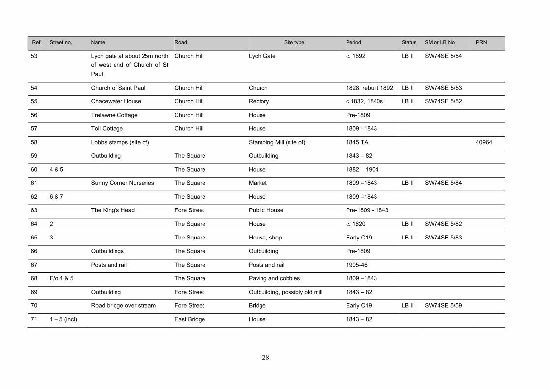
Ref. Street no. Name Road Site type Period Status SM or LB No PRN
1 Sett boundary stone inscribed CB on one side, WB on the other
High Street Sett boundary stone C18/ early C19
2 Lantern Cottage High Street House 1809 -1843
3 Greensleeves High Street House Pre-1809
4 1 – 3 Rose Cottages High Street House 1843 – 82
5 F/o 1-3 Rose Cottages High Street Gate, wall and railings 1843 – 82
6 The Great Walled Garden High Street Garden wall Early C19
7 F/o Doon Brae & Bostrase High Street Foundations of wall Early C19
8 High Street Outbuilding 1882 – 1904
9 7 High Street House 1809 –1843
10 8 High Street Post Office (now house) 1843 - 82
11 9 Formerly Crown Inn High Street Inn (now house) 1809 –1843
12 The Stables High Street House 1843 – 82
13 Woodside High Street House c. Mid - Late C18 LB II SW74SW 4/56
14 10 & 11 High Street House (2) 1809 -1843 LB II SW74SW 4/75
15 12 High Street House c. Early C19 LB II SW74SW 4/190
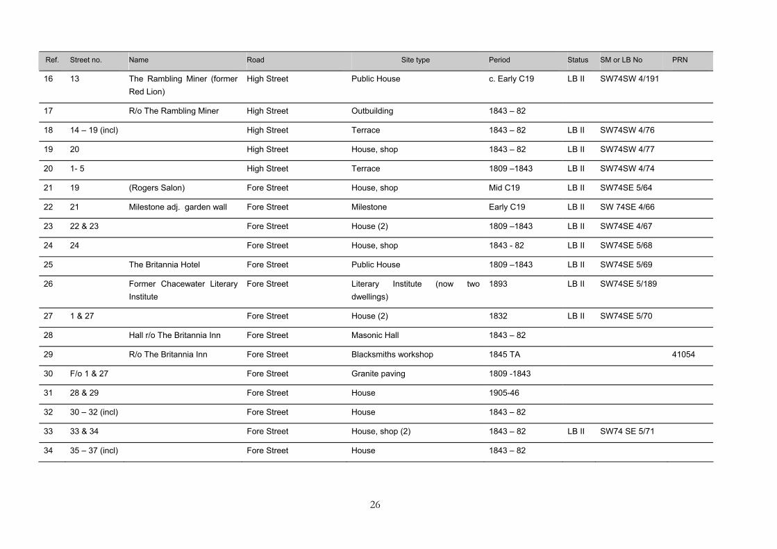
26
Ref. Street no. Name Road Site type Period Status SM or LB No PRN
16 13 The Rambling Miner (former Red Lion)
High Street Public House c. Early C19 LB II SW74SW 4/191
17 R/o The Rambling Miner High Street Outbuilding 1843 – 82
18 14 – 19 (incl) High Street Terrace 1843 – 82 LB II SW74SW 4/76
19 20 High Street House, shop 1843 – 82 LB II SW74SW 4/77
20 1- 5 High Street Terrace 1809 –1843 LB II SW74SW 4/74
21 19 (Rogers Salon) Fore Street House, shop Mid C19 LB II SW74SE 5/64
22 21 Milestone adj. garden wall Fore Street Milestone Early C19 LB II SW 74SE 4/66
23 22 & 23 Fore Street House (2) 1809 –1843 LB II SW74SE 4/67
24 24 Fore Street House, shop 1843 - 82 LB II SW74SE 5/68
25 The Britannia Hotel Fore Street Public House 1809 –1843 LB II SW74SE 5/69
26 Former Chacewater Literary Institute
Fore Street Literary Institute (now two dwellings)
1893 LB II SW74SE 5/189
27 1 & 27 Fore Street House (2) 1832 LB II SW74SE 5/70
28 Hall r/o The Britannia Inn Fore Street Masonic Hall 1843 – 82
29 R/o The Britannia Inn Fore Street Blacksmiths workshop 1845 TA 41054
30 F/o 1 & 27 Fore Street Granite paving 1809 -1843
31 28 & 29 Fore Street House 1905-46
32 30 – 32 (incl) Fore Street House 1843 – 82
33 33 & 34 Fore Street House, shop (2) 1843 – 82 LB II SW74 SE 5/71
34 35 – 37 (incl) Fore Street House 1843 – 82
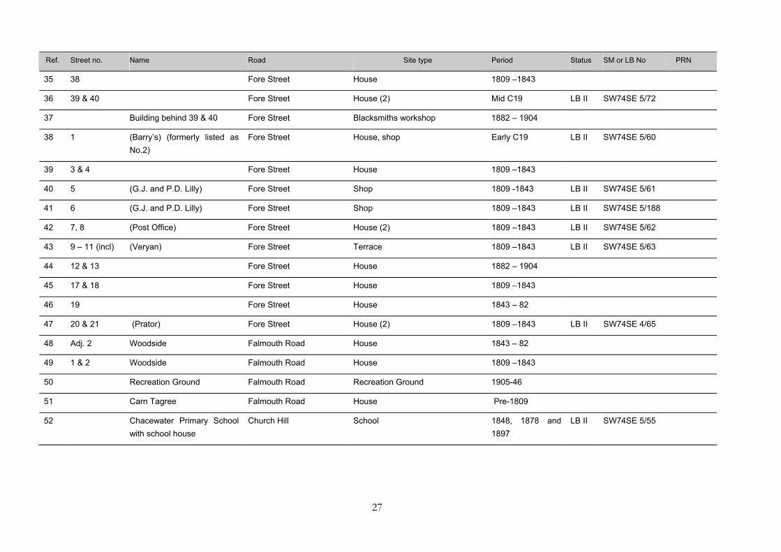
27
Ref. Street no. Name Road Site type Period Status SM or LB No PRN
35 38 Fore Street House 1809 –1843
36 39 & 40 Fore Street House (2) Mid C19 LB II SW74SE 5/72
37 Building behind 39 & 40 Fore Street Blacksmiths workshop 1882 – 1904
38 1 (Barry’s) (formerly listed as No.2)
Fore Street House, shop Early C19 LB II SW74SE 5/60
39 3 & 4 Fore Street House 1809 –1843
40 5 (G.J. and P.D. Lilly) Fore Street Shop 1809 -1843 LB II SW74SE 5/61
41 6 (G.J. and P.D. Lilly) Fore Street Shop 1809 –1843 LB II SW74SE 5/188
42 7, 8 (Post Office) Fore Street House (2) 1809 –1843 LB II SW74SE 5/62
43 9 – 11 (incl) (Veryan) Fore Street Terrace 1809 –1843 LB II SW74SE 5/63
44 12 & 13 Fore Street House 1882 – 1904
45 17 & 18 Fore Street House 1809 –1843
46 19 Fore Street House 1843 – 82
47 20 & 21 (Prator) Fore Street House (2) 1809 –1843 LB II SW74SE 4/65
48 Adj. 2 Woodside Falmouth Road House 1843 – 82
49 1 & 2 Woodside Falmouth Road House 1809 –1843
50 Recreation Ground Falmouth Road Recreation Ground 1905-46
51 Carn Tagree Falmouth Road House Pre-1809
52 Chacewater Primary School with school house
Church Hill School 1848, 1878 and 1897
LB II SW74SE 5/55
28
Ref. Street no. Name Road Site type Period Status SM or LB No PRN
53 Lych gate at about 25m north of west end of Church of St Paul
Church Hill Lych Gate c. 1892 LB II SW74SE 5/54
54 Church of Saint Paul Church Hill Church 1828, rebuilt 1892 LB II SW74SE 5/53
55 Chacewater House Church Hill Rectory c.1832, 1840s LB II SW74SE 5/52
56 Trelawne Cottage Church Hill House Pre-1809
57 Toll Cottage Church Hill House 1809 –1843
58 Lobbs stamps (site of) Stamping Mill (site of) 1845 TA 40964
59 Outbuilding The Square Outbuilding 1843 – 82
60 4 & 5 The Square House 1882 – 1904
61 Sunny Corner Nurseries The Square Market 1809 –1843 LB II SW74SE 5/84
62 6 & 7 The Square House 1809 –1843
63 The King’s Head Fore Street Public House Pre-1809 - 1843
64 2 The Square House c. 1820 LB II SW74SE 5/82
65 3 The Square House, shop Early C19 LB II SW74SE 5/83
66 Outbuildings The Square Outbuilding Pre-1809
67 Posts and rail The Square Posts and rail 1905-46
68 F/o 4 & 5 The Square Paving and cobbles 1809 –1843
69 Outbuilding Fore Street Outbuilding, possibly old mill 1843 – 82
70 Road bridge over stream Fore Street Bridge Early C19 LB II SW74SE 5/59
71 1 – 5 (incl) East Bridge House 1843 – 82
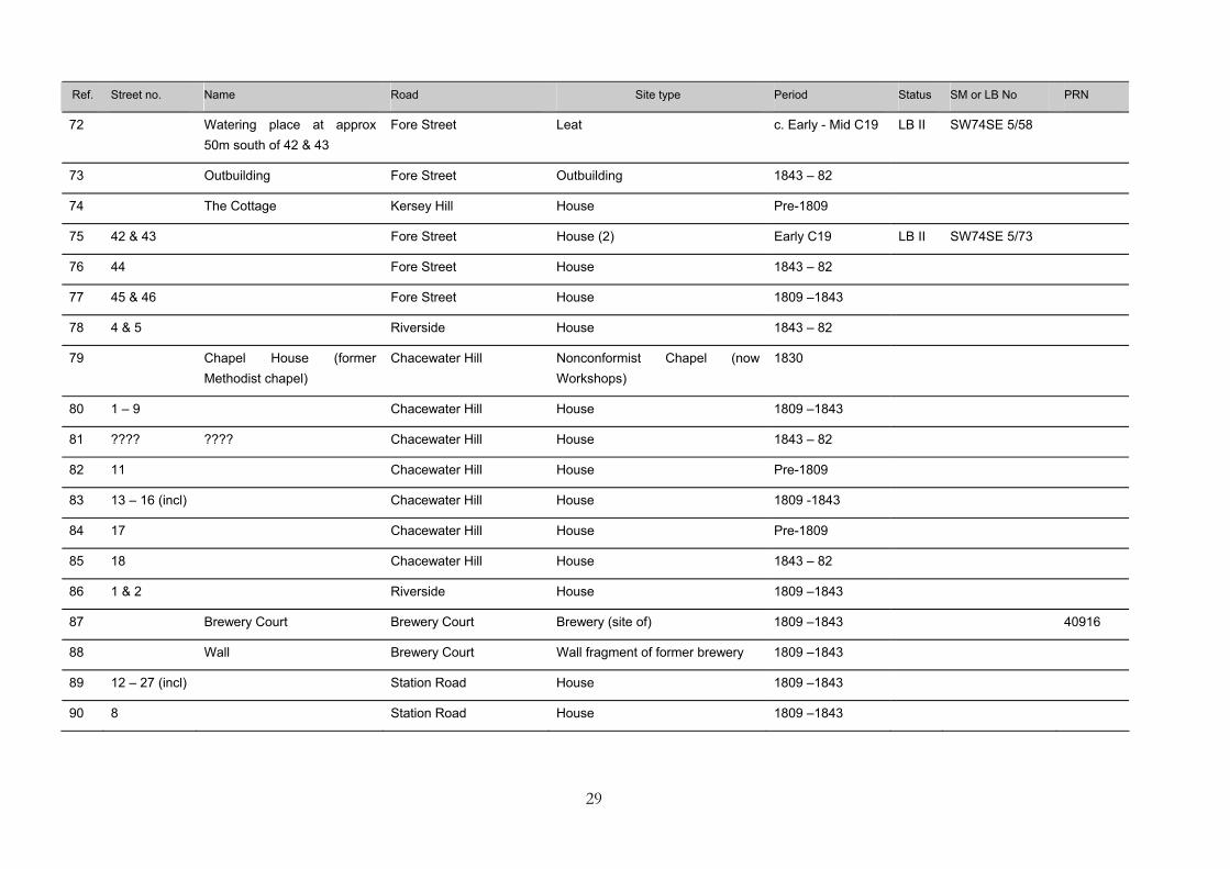
29
Ref. Street no. Name Road Site type Period Status SM or LB No PRN
72 Watering place at approx 50m south of 42 & 43
Fore Street Leat c. Early - Mid C19 LB II SW74SE 5/58
73 Outbuilding Fore Street Outbuilding 1843 – 82
74 The Cottage Kersey Hill House Pre-1809
75 42 & 43 Fore Street House (2) Early C19 LB II SW74SE 5/73
76 44 Fore Street House 1843 – 82
77 45 & 46 Fore Street House 1809 –1843
78 4 & 5 Riverside House 1843 – 82
79 Chapel House (former Methodist chapel)
Chacewater Hill Nonconformist Chapel (now Workshops)
1830
80 1 – 9 Chacewater Hill House 1809 –1843
81 ???? ???? Chacewater Hill House 1843 – 82
82 11 Chacewater Hill House Pre-1809
83 13 – 16 (incl) Chacewater Hill House 1809 -1843
84 17 Chacewater Hill House Pre-1809
85 18 Chacewater Hill House 1843 – 82
86 1 & 2 Riverside House 1809 –1843
87 Brewery Court Brewery Court Brewery (site of) 1809 –1843 40916
88 Wall Brewery Court Wall fragment of former brewery 1809 –1843
89 12 – 27 (incl) Station Road House 1809 –1843
90 8 Station Road House 1809 –1843
30
Ref. Street no. Name Road Site type Period Status SM or LB No PRN
91 10 Station Road House 1809 –82
92 Station Road Post and rail Early –mid C19
93 4 – 7 (incl) North Hill House 1809 –1843
94 Greenbank North Hill House 1809 – 1882
95 North Hill House North Hill House 1809 –1843
96 Outbuilding North Hill House (now outbuilding) Pre-1809
97 Outbuilding North Hill House (now outbuilding) 1809-43
98 29 – 32 Station Road House 1843 – 82
99 33 – 35 (incl) Station Road House 1843 – 82
100 Chapel Station Road Nonconformist Chapel 1843 - 82
101 The Terrace Wall fragment 1843 – 82
102 3, 4 & 5 The Terrace House 1809 –1843
103 6 The Terrace House Pre-1809
104 Pitsleweren Stamps (site of) The Terrace Stamping Mill (site of) 1845 TA 41045
105 7 & 8 The Terrace House 1882 – 1904
106 Brookside - Stamping Mill (site of)
The Terrace Stamping Mill (site of) 1845 TA 41044
107 The Willows The Terrace House 1809 –1843
108 9 & 10 The Terrace House 1843 – 82
109 12 The Terrace House 1809 –1843
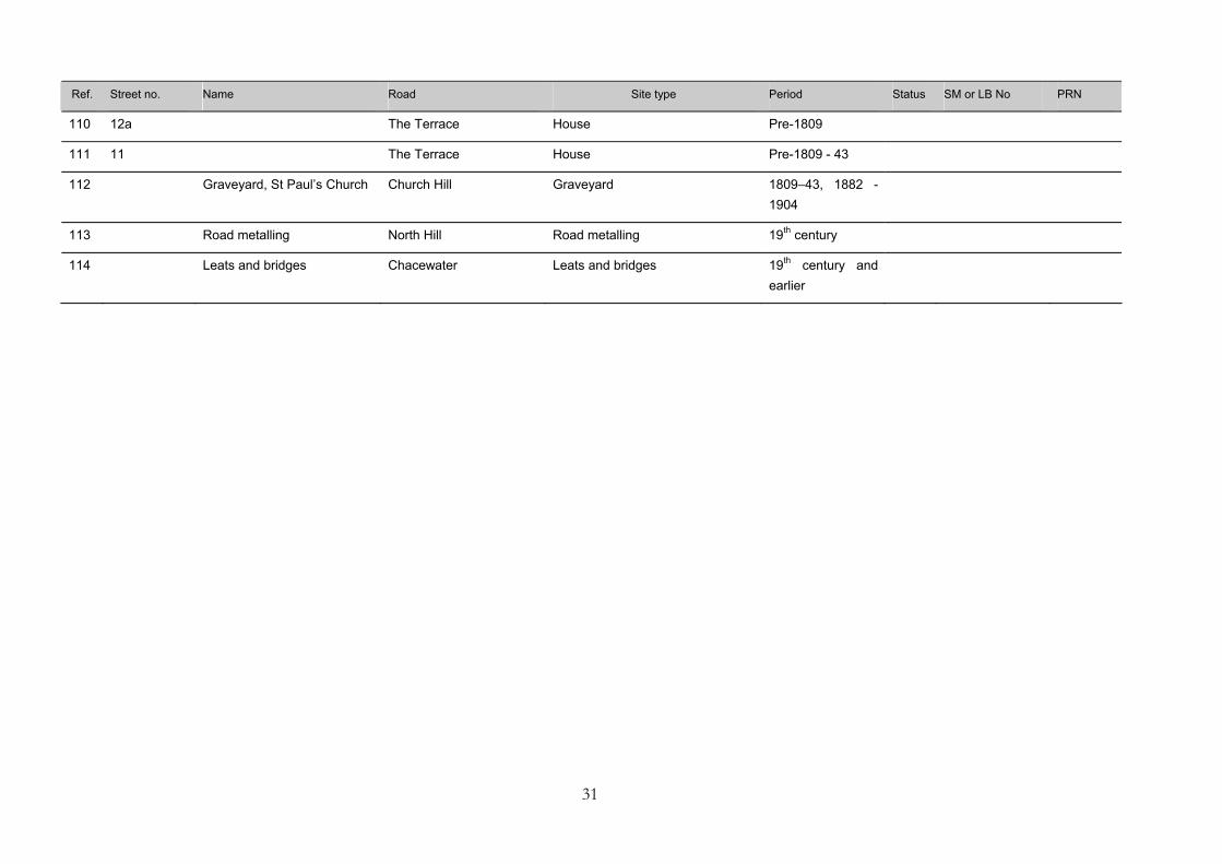
31
Ref. Street no. Name Road Site type Period Status SM or LB No PRN
110 12a The Terrace House Pre-1809
111 11 The Terrace House Pre-1809 - 43
112 Graveyard, St Paul’s Church Church Hill Graveyard 1809–43, 1882 - 1904
113 Road metalling North Hill Road metalling 19th century
114 Leats and bridges Chacewater Leats and bridges 19th century and earlier

32
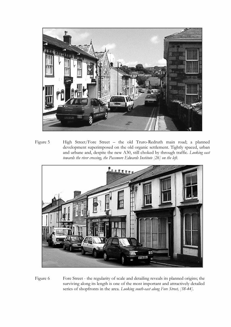
Figure 5 High Street/Fore Street – the old Truro-Redruth main road; a planned development superimposed on the old organic settlement. Tightly spaced, urban and urbane and, despite the new A30, still choked by through traffic. Looking east towards the river crossing, the Passmore Edwards Institute [26] on the left.
Figure 6 Fore Street - the regularity of scale and detailing reveals its planned origins; the surviving along its length is one of the most important and attractively detailed series of shopfronts in the area. Looking south-east along Fore Street, [38-44].
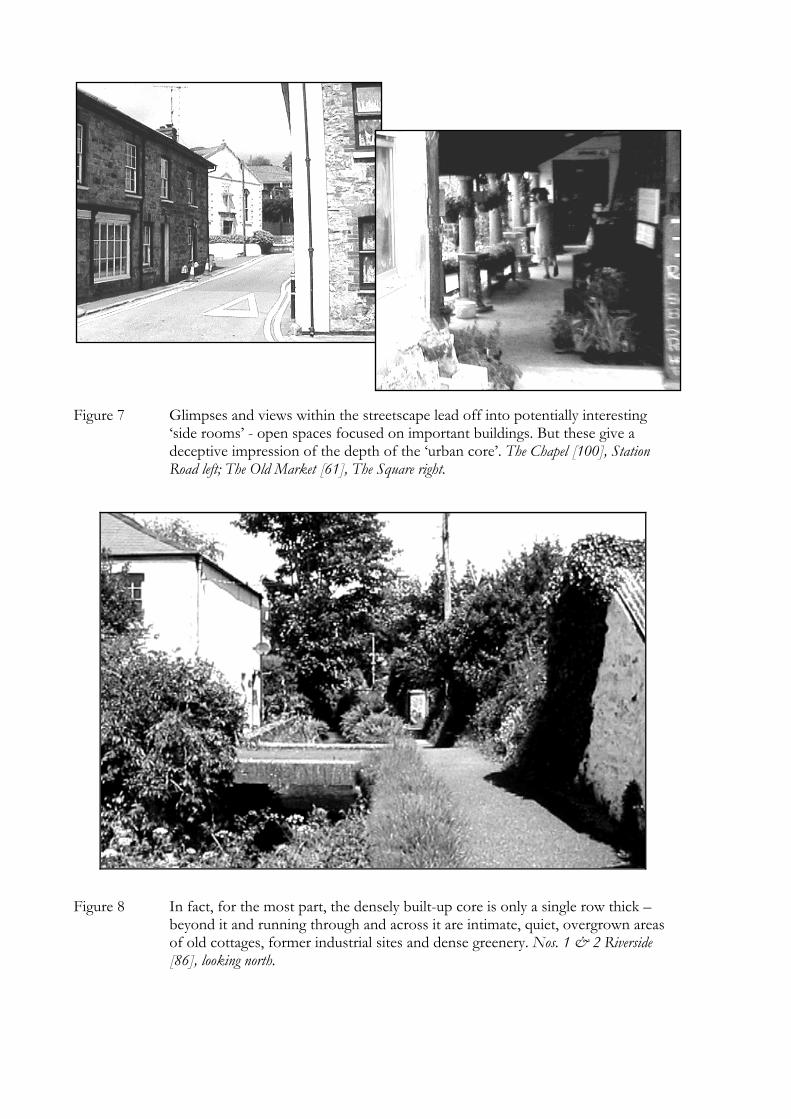
Figure 7 Glimpses and views within the streetscape lead off into potentially interesting ‘side rooms’ - open spaces focused on important buildings. But these give a deceptive impression of the depth of the ‘urban core’. The Chapel [100], Station Road left; The Old Market [61], The Square right.
Figure 8 In fact, for the most part, the densely built-up core is only a single row thick –beyond it and running through and across it are intimate, quiet, overgrown areas of old cottages, former industrial sites and dense greenery. Nos. 1 & 2 Riverside [86], looking north.
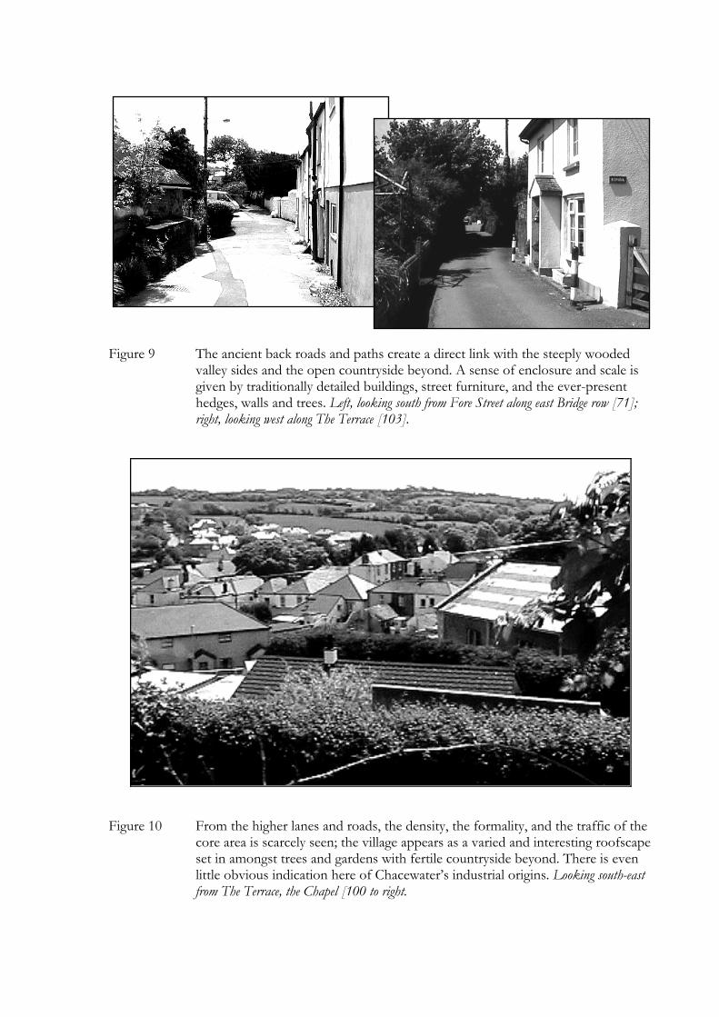
Figure 9 The ancient back roads and paths create a direct link with the steeply wooded valley sides and the open countryside beyond. A sense of enclosure and scale is given by traditionally detailed buildings, street furniture, and the ever-present hedges, walls and trees. Left, looking south from Fore Street along east Bridge row [71]; right, looking west along The Terrace [103].
Figure 10 From the higher lanes and roads, the density, the formality, and the traffic of the core area is scarcely seen; the village appears as a varied and interesting roofscape set in amongst trees and gardens with fertile countryside beyond. There is even little obvious indication here of Chacewater’s industrial origins. Looking south-east from The Terrace, the Chapel [100 to right.