Embed Size (px)
Citation preview
Chacewater Conservation Area Appraisal
March 2010
This Conservation Area Appraisal was commissioned by Carrick District Council. At the Carrick Cabinet meeting on 17 March 2009 Members resolved to recommend to the Joint Implementation Executive that the Chacewater Conservation Area Appraisal be adopted. It was subsequently endorsed by Cornwall Council as a material consideration within the emerging Cornwall Council Local Development Framework on 24 April 2010. The recommended changes to the boundaries of Chacewater Conservation Area were authorised by Cornwall Council and came into effect on 24 April 2010.
Contents
1. Statement of the special interest of the conservation area 1
2. Introduction 3
2.1 Background 32.2 Planning policy context 32.3 Purpose of the appraisal 52.4 Community involvement 5
3. The Chacewater Conservation Area 7
3.1 Designation 73.2 Geographic location & setting 73.3 Activities 7
4. Evolution of the area 9
4.1 Archaeological significance and potential 94.2 Historical development 10
5. Landscape character 13
5.1 Landscape and settlement edges 135.2 Topography 145.3 Geology 145.4 Views and vistas 165.5 Trees 165.6 Planting and green spaces 175.7 Biodiversity 17
6. Spatial analysis 19
6.1 Layout and spaces 196.2 Relationship of buildings to spaces 206.3 Landmarks, focal points and connections 21
CHACEWATER CONSERVATION AREA CHARACTER APPRAISAL
Chacewater DTP.indd 4 10/12/2008 10:17:56
March 2010
7. Streetscape character 22
7.1 Public spaces 227.2 Signage and Street furniture 227.3 Lighting 227.4 Paving 247.5 Boundary treatments 257.6 Traffic and parking 257.7 Pedestrians and movement 25
8. The buildings of the conservation area 27
8.1 Building types 278.2 Building form 288.3 Building uses 288.4 Listed buildings 298.5 Locally listed buildings 308.6 Positive buildings 308.7 Building materials 308.8 Local details 31
9. Character Areas 37
9.1 Summary of character areas 379.2 Character Area 1: High Street / Fore Street 379.3 Character Area 2: South side 379.4 Character Area 3: The east end 399.5 Character Area 4: Riverside 40
10. Issues 43
10.1 Definition of issues 4310.2 Conservation area boundary review 4310.3 Education and information 4310.4 Buildings-at-risk 4310.5 Alterations to buildings 4310.6 New development 4410.7 Uses/vitality 4410.8 Locally listed buildings 4510.9 Enforcement 4510.10 Highways and traffic management 4510.11 Archaeological potential 4510.12 Enhancement potential 4610.13 Trees 4610.14 Sustainable development 46
Appendices:
Appendix 1 Historical development of Chacewater 49
Appendix 2 Maps: 54
Map 1 Character areas ecological designations 55Map 2 Townscape appraisal map 56
Appendix 3 References 57
CHACEWATER CONSERVATION AREA CHARACTER APPRAISAL
Chacewater DTP.indd 5 10/12/2008 10:17:56
March 2010
STATEMENT OF THE SPECIAL INTEREST OF THE CONSERVATION AREA
Chapter 1
CHACEWATER CONSERVATION AREA CHARACTER APPRAISAL
Chacewater DTP.indd 8 10/12/2008 10:17:56
March 2010
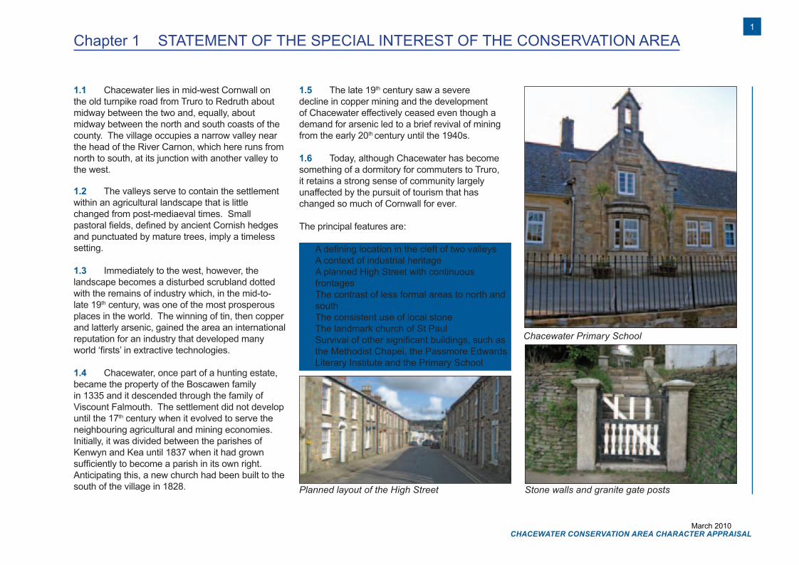
Chacewater Primary School
Stone walls and granite gate postsPlanned layout of the High Street
Chapter 1 STATEMENT OF THE SPECIAL INTEREST OF THE CONSERVATION AREA
1.1 Chacewater lies in mid-west Cornwall on the old turnpike road from Truro to Redruth about midway between the two and, equally, about midway between the north and south coasts of the county. The village occupies a narrow valley near the head of the River Carnon, which here runs from north to south, at its junction with another valley to the west.
1.2 The valleys serve to contain the settlement within an agricultural landscape that is little changed from post-mediaeval times. Small pastoral fields, defined by ancient Cornish hedges and punctuated by mature trees, imply a timeless setting.
1.3 Immediately to the west, however, the landscape becomes a disturbed scrubland dotted with the remains of industry which, in the mid-to-late 19th century, was one of the most prosperous places in the world. The winning of tin, then copper and latterly arsenic, gained the area an international reputation for an industry that developed many world ‘firsts’ in extractive technologies.
1.4 Chacewater, once part of a hunting estate, became the property of the Boscawen family in 1335 and it descended through the family of Viscount Falmouth. The settlement did not develop until the 17th century when it evolved to serve the neighbouring agricultural and mining economies. Initially, it was divided between the parishes of Kenwyn and Kea until 1837 when it had grown sufficiently to become a parish in its own right. Anticipating this, a new church had been built to the south of the village in 1828.
1.5 The late 19th century saw a severe decline in copper mining and the development of Chacewater effectively ceased even though a demand for arsenic led to a brief revival of mining from the early 20th century until the 1940s.
1.6 Today, although Chacewater has become something of a dormitory for commuters to Truro, it retains a strong sense of community largely unaffected by the pursuit of tourism that has changed so much of Cornwall for ever.
The principal features are:
• A defining location in the cleft of two valleys• A context of industrial heritage• A planned High Street with continuous
frontages• The contrast of less formal areas to north and
south• The consistent use of local stone• The landmark church of St Paul• Survival of other significant buildings, such as
the Methodist Chapel, the Passmore Edwards Literary Institute and the Primary School
1
CHACEWATER CONSERVATION AREA CHARACTER APPRAISAL
Chacewater DTP.indd 1 10/12/2008 10:18:06
March 2010

INTRODUCTIONChapter 2
CHACEWATER CONSERVATION AREA CHARACTER APPRAISAL
2
Chacewater DTP.indd 2 10/12/2008 10:18:06
March 2010
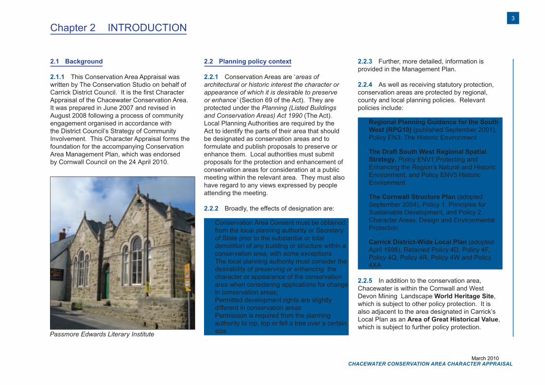
Passmore Edwards Literary Institute
Chapter 2 INTRODUCTION
2.1 Background
2.1.1 This Conservation Area Appraisal was written by The Conservation Studio on behalf of Carrick District Council. It is the first Character Appraisal of the Chacewater Conservation Area. It was prepared in June 2007 and revised in August 2008 following a process of community engagement organised in accordance with the District Council’s Strategy of Community Involvement. This Character Appraisal forms the foundation for the accompanying Conservation Area Management Plan, which was endorsedby Cornwall Council on the 24 April 2010.
2.2 Planning policy context
2.2.1 Conservation Areas are ‘areas of architectural or historic interest the character or appearance of which it is desirable to preserve or enhance’ (Section 69 of the Act). They are protected under the Planning (Listed Buildings and Conservation Areas) Act 1990 (The Act). Local Planning Authorities are required by the Act to identify the parts of their area that should be designated as conservation areas and to formulate and publish proposals to preserve or enhance them. Local authorities must submit proposals for the protection and enhancement of conservation areas for consideration at a public meeting within the relevant area. They must also have regard to any views expressed by people attending the meeting.
2.2.2 Broadly, the effects of designation are:
• Conservation Area Consent must be obtained from the local planning authority or Secretary of State prior to the substantial or total demolition of any building or structure within a conservation area, with some exceptions
• The local planning authority must consider the desirability of preserving or enhancing the character or appearance of the conservation area when considering applications for change in conservation areas;
• Permitted development rights are slightly different in conservation areas
• Permission is required from the planning authority to lop, top or fell a tree over a certain size
2.2.3 Further, more detailed, information is provided in the Management Plan.
2.2.4 As well as receiving statutory protection, conservation areas are protected by regional, county and local planning policies. Relevant policies include:
• Regional Planning Guidance for the South West (RPG10) (published September 2001), Policy EN3: The Historic Environment
• The Draft South West Regional Spatial Strategy, Policy ENV1 Protecting and Enhancing the Region’s Natural and Historic Environment, and Policy ENV5 Historic Environment
• The Cornwall Structure Plan (adopted September 2004), Policy 1. Principles for Sustainable Development, and Policy 2. Character Areas, Design and Environmental Protection
• Carrick District-Wide Local Plan (adopted April 1998), Retained Policy 4D, Policy 4F, Policy 4Q, Policy 4R, Policy 4W and Policy 4XA
2.2.5 In addition to the conservation area, Chacewater is within the Cornwall and West Devon Mining Landscape World Heritage Site, which is subject to other policy protection. It is also adjacent to the area designated in Carrick’s Local Plan as an Area of Great Historical Value, which is subject to further policy protection.
3
CHACEWATER CONSERVATION AREA CHARACTER APPRAISAL
Chacewater DTP.indd 3 10/12/2008 10:18:09
March 2010
Chapter 2
Track
Hillside
kenw
ith
NO
RTH
HILL
Tre-Bron
Chymen
eth
Try-Golva
Chy-an
-Brec
3
Brockenhurst
5
Cheverney
6
17 to 28
Brookside
9 to 16
1 to 8
Willows
THE TERRACE
7
8
9
12
La Caprice
12a
Rose
Cottages
74.6m
Stone GP
69.4m
67.1m
The Great Walled
Garden
65.5m
Tremarner
64.2m
BM 64.83m
71.5m
89
6
HIGH STREET
10
PH
13
14
20
20
22
MS
1959.4m
1a
1b
5
21
Woodside
Cottages
Recreation
Ground
Pavilion
Track
78.3m
Path
(um
)
BM 88.81m
93.0m
Anzac
Cottages
99.7m
BM 104.46m
Meadowmist
108.2m
105.9m
Track
7
A 390
Track
1
FALMOUTH ROAD
Astega
Sundown
Cottage
Trewin
Chybean
The
Cedar Wood
BUCK
ING
HA
M N
IP
SERG
EAN
TS H
ILL
Kerley
Torre
Carn Lea
High
April
7172
7361
6359
6751
7753
8652
5314
5406
5600 6100 6600 7100 9600
9506
9912
9517
8311
8421
7918
8231
5928
5950
1 to 3
Greensleeves
Bostrase
Am
berley
Cottage
Menhegy
House
View
12
The
Barn
Cottage
Lantern
Melbury
1
2
Doon Brae
The Stables
Creegbrawse Cottage
Woodside
Bow
ling
Gre
en
34
13
9
13
17
2
3
7
1
27
24
19
1
9
1
13
718
17
16
13
11
10
6
12
27
2014
1559
2412
0307
0104
2009
2700
9
1
2
4
45
46
44
42
28
34
33
40
32
35
Trenessa
North Hill
House
Estrella
NORTH
HILL
Seasons
St Jay's
Lodge
Church
Hall
PH
Inst
57.1m
PO
PH
54.9m
BM 55.76m
60.9m
67.8m
The
Cot
tage
Westering
Crossw
ays
ROSELAND CR
Vidill
East Bridge
55.2m
55.9m
50.8m
BM 52.98m
Lower
Chancewood
BM 82.02m
War Meml
St Paul's Church
Path
54.3m
Glenm
or
Umina
86.5m
91.3m
80.4m
Trelawne
Track
BM 72.23m
70.2m
64.9m
Hall
59.0m
BM 60.86m
Toll
Cottage
PC
TCB
Car Park
PlayArea
Trewlawne
Cottage
CH
URC
HH
ILL
Pavilion
Chacewater
Chapel
House
FB
Riverside
THE TERRACE
FORE STREET
THE SQ
UA
RE
1
5
BM 65.20m
Eckla Vue
Hetherlee
1
2
Brewery
Ct
FB
12
35
6
54
JAKE
'S LA
NE
Inst
Chacewater Junior
& Infant School
Vicarage
Lych Gate
4
28
32
35
33
Post
Recreation
Ground
3
1
Hod
ges
Cou
rt
FB
Lower
Chacewood
Cottage
LOW
ER
MEAD
OW
4
1
Truran
Ho
5
Rose
vean
Meadow
Springs
Tresco
Pine
View
Bremar
Glenhaven
Kenwith
Chapel
Ct
12
Carn
Tagree
Robern
7
1
19
18
16
14
10
1
4
KERLEY
KERLEY
VALE
VALE
27
22
20
Greenbank
1
3
Health C
entre
Regeana
20
22
31
26
25
23
27
28
The Thimble
The
Yard
1
Bowling
Green
BaddonCottage
3
4
1
2Cornwall
Cornwall Council
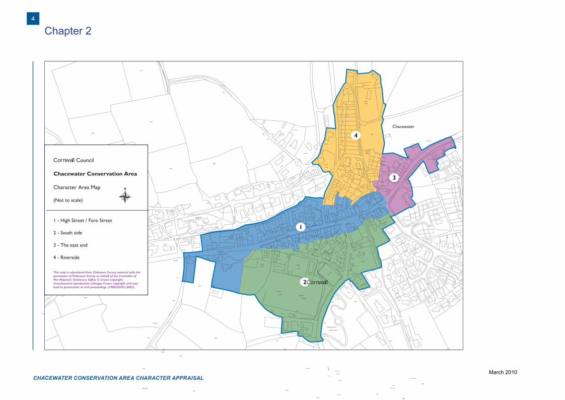
Chacewater Conservation Area
Character Area Map
(Not to scale)
1 - High Street / Fore Street
2 - South side
3 - The east end
4 - Riverside
This map is reproduced from Ordnance Survey material with the permission of Ordnance Survey on behalf of the Controller of Her Majesty's Stationery Office © Crown copyright. Unauthorised reproduction infringes Crown copyright and may lead to prosecution or civil proceedings. (100023554) (2007).
CHACEWATER CONSERVATION AREA CHARACTER APPRAISAL
4
Chacewater DTP.indd 4 10/12/2008 10:18:10
March 2010
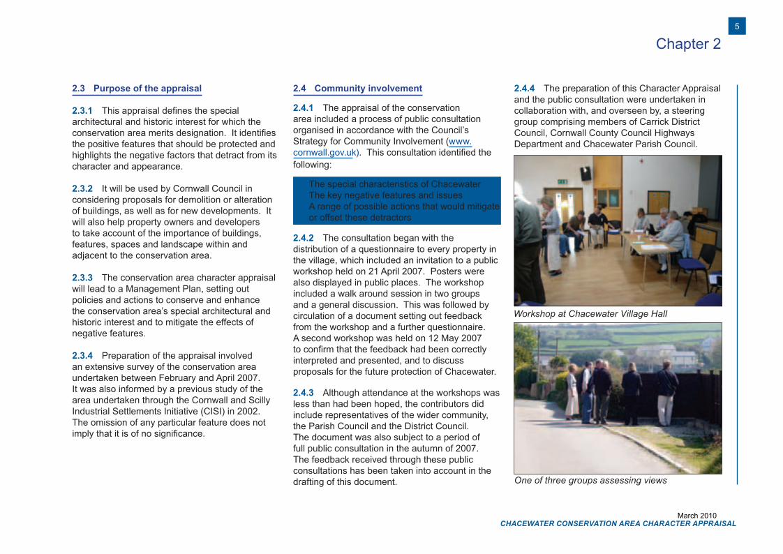
Workshop at Chacewater Village Hall
One of three groups assessing views
Chapter 2
2.3 Purpose of the appraisal
2.3.1 This appraisal defines the special architectural and historic interest for which the conservation area merits designation. It identifies the positive features that should be protected and highlights the negative factors that detract from its character and appearance.
2.3.2 It will be used by Cornwall Council in considering proposals for demolition or alteration of buildings, as well as for new developments. It will also help property owners and developers to take account of the importance of buildings, features, spaces and landscape within and adjacent to the conservation area.
2.3.3 The conservation area character appraisal will lead to a Management Plan, setting out policies and actions to conserve and enhance the conservation area’s special architectural and historic interest and to mitigate the effects of negative features.
2.3.4 Preparation of the appraisal involved an extensive survey of the conservation area undertaken between February and April 2007. It was also informed by a previous study of the area undertaken through the Cornwall and Scilly Industrial Settlements Initiative (CISI) in 2002. The omission of any particular feature does not imply that it is of no significance.
2.4 Community involvement
2.4.1 The appraisal of the conservation area included a process of public consultation organised in accordance with the Council’s Strategy for Community Involvement (www.cornwall.gov.uk). This consultation identified the following:
• The special characteristics of Chacewater• The key negative features and issues• A range of possible actions that would mitigate
or offset these detractors
2.4.2 The consultation began with the distribution of a questionnaire to every property in the village, which included an invitation to a public workshop held on 21 April 2007. Posters were also displayed in public places. The workshop included a walk around session in two groups and a general discussion. This was followed by circulation of a document setting out feedback from the workshop and a further questionnaire. A second workshop was held on 12 May 2007 to confirm that the feedback had been correctly interpreted and presented, and to discuss proposals for the future protection of Chacewater.
2.4.3 Although attendance at the workshops was less than had been hoped, the contributors did include representatives of the wider community, the Parish Council and the District Council. The document was also subject to a period of full public consultation in the autumn of 2007. The feedback received through these public consultations has been taken into account in the drafting of this document.
2.4.4 The preparation of this Character Appraisal and the public consultation were undertaken in collaboration with, and overseen by, a steering group comprising members of Carrick District Council, Cornwall County Council Highways Department and Chacewater Parish Council.
5
CHACEWATER CONSERVATION AREA CHARACTER APPRAISAL
Chacewater DTP.indd 5 10/12/2008 10:18:13
March 2010

THE CHACEWATER CONSERVATION AREAChapter 3
CHACEWATER CONSERVATION AREA CHARACTER APPRAISAL
6
Chacewater DTP.indd 6 10/12/2008 10:18:14
March 2010
3.1 Designation
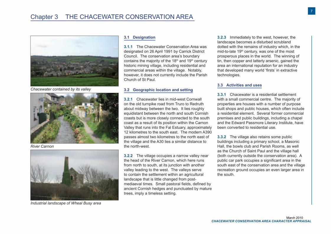
3.1.1 The Chacewater Conservation Area was designated on 26 April 1991 by Carrick District Council. The conservation area’s boundary contains the majority of the 18th and 19th century historic mining village, including residential and commercial areas within the village. Notably, however, it does not currently include the Parish Church of St Paul.
3.2 Geographic location and setting
3.2.1 Chacewater lies in mid-west Cornwall on the old turnpike road from Truro to Redruth about midway between the two. It lies roughly equidistant between the north and south Cornish coasts but is more closely connected to the south coast as a result of its position within the Carnon Valley that runs into the Fal Estuary, approximately 12 kilometres to the south east. The modern A390 passes almost two kilometres to the north east of the village and the A30 lies a similar distance to the north-west.
3.2.2 The village occupies a narrow valley near the head of the River Carnon, which here runs from north to south, at its junction with another valley leading to the west. The valleys serve to contain the settlement within an agricultural landscape that is little changed from post-mediaeval times. Small pastoral fields, defined by ancient Cornish hedges and punctuated by mature trees, imply a timeless setting.
3.2.3 Immediately to the west, however, the landscape becomes a disturbed scrubland dotted with the remains of industry which, in the mid-to-late 19th century, was one of the most prosperous places in the world. The winning of tin, then copper and latterly arsenic, gained the area an international reputation for an industry that developed many world ‘firsts’ in extractive technologies.
3.3 Activities and uses
3.3.1 Chacewater is a residential settlement with a small commercial centre. The majority of properties are houses with a number of purpose built shops and public houses, which often include a residential element. Several former commercial premises and public buildings, including a chapel and the Edward Passmore Literary Institute, have been converted to residential use.
3.3.2 The village also retains some public buildings including a primary school, a Masonic Hall, the bowls club and Parish Rooms, as well as the Church of Saint Paul and the village hall (both currently outside the conservation area). A public car park occupies a significant area in the south east of the conservation area and the village recreation ground occupies an even larger area in the south.
Chapter 3 THE CHACEWATER CONSERVATION AREA
Chacewater contained by its valley
River Carnon
Industrial landscape of Wheal Busy area
7
CHACEWATER CONSERVATION AREA CHARACTER APPRAISAL
Chacewater DTP.indd 7 10/12/2008 10:18:26
March 2010
EVOLUTION OF THE AREAChapter 4
CHACEWATER CONSERVATION AREA CHARACTER APPRAISAL
8
Chacewater DTP.indd 8 10/12/2008 10:18:26
March 2010
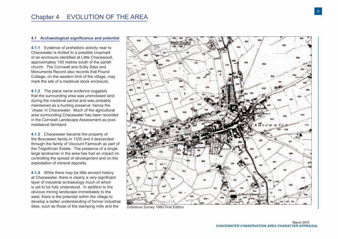
4.1 Archaeological significance and potential
4.1.1 Evidence of prehistoric activity near to Chacewater is limited to a possible cropmark of an enclosure identified at Little Chacewood, approximately 100 metres south of the parish church. The Cornwall and Scilly Sites and Monuments Record also records that Pound Cottage, on the western limit of the village, may mark the site of a medieval stock enclosure.
4.1.2 The place name evidence suggests that the surrounding area was unenclosed land during the medieval period and was probably maintained as a hunting preserve: hence the ‘chase’ in Chacewater. Much of the agricultural area surrounding Chacewater has been recorded in the Cornwall Landscape Assessment as post-mediaeval farmland.
4.1.3 Chacewater became the property of the Boscawen family in 1335 and it descended through the family of Viscount Falmouth as part of the Tregothnan Estate. The presence of a single large landowner in the area has had an impact on controlling the spread of development and on the exploitation of mineral deposits.
4.1.4 While there may be little ancient history at Chacewater, there is clearly a very significant layer of industrial archaeology much of which is yet to be fully understood. In addition to the obvious mining landscape immediately to the west, there is the potential within the village to develop a better understanding of former industrial sites, such as those of the stamping mills and the
Chapter 4 EVOLUTION OF THE AREA
Ordnance Survey 1880 First Edition
9
CHACEWATER CONSERVATION AREA CHARACTER APPRAISAL
Chacewater DTP.indd 9 10/12/2008 10:18:28
March 2010
brewery, and the network of watercourses that linked them. It is thought, for instance, that much of the space between High Street and the Terrace was once colonised by industry, the demise of which explains the relatively modern housing that stands there now.
4.2 Historical development
4.2.1 A more detailed account of the history of Chacewater is provided in Appendix 1 – Historical development of Chacewater, and in the Cornwall Industrial Settlements Initiative (CISI) report of 2002 (www.historic-cornwall.org.uk/cisi).
4.2.2 The first possible record of the village appears on Joel Gascoyne’s map of Cornwall of 1699. A tin mine, named the Great Works, had also been recorded in the vicinity of Chacewater in the 16th century. This later became known as Wheal Busy and, by the early 18th century, it had become one of Cornwall’s most significant mines producing large amounts of copper.
4.2.3 It appears that the original settlement comprised a loose grouping of smallholdings, reflecting the mixed economy practiced by the early tin miners. However, the first Ordnance Survey one inch map of 1809 records that a village centre had been established by that date following the east-west alignment of the main road.
4.2.4 During the 19th century Chacewater developed as an economic and civic centre for the farming and industrial communities, becoming
a parish in its own right in 1837. The Tithe map of 1841 shows the areas of more scattered housing along the Terrace, North Hill, High Street and Falmouth Road, as well as the planned development of terraces along Fore Street, the Square and Station Road, the latter being housing for the adjacent brewery.
4.2.5 As mining declined during the 19th century, the character of the area changed through the increasing presence of market gardens and fruit growing. This process was stimulated by the opening of the railway line in 1852 and improved access it gave to urban markets.
4.2.6 Demand for arsenic led to a brief revival of mining in the early 20th century, but by then, Chacewater continued to function more as an agricultural centre. After the closure of the mines and with the increasing use of motorcars from 1946, the village began to function as a dormitory settlement for Truro. The railway station was closed in 1964 ‘sealing Chacewater’s fate as an economic backwater’. (CISI report - 2002)
Chapter 4
Milestone in Fore Street
River Carnon
Leat to west of High Street
CHACEWATER CONSERVATION AREA CHARACTER APPRAISAL
10
Chacewater DTP.indd 10 10/12/2008 10:18:44
March 2010
Chapter 4
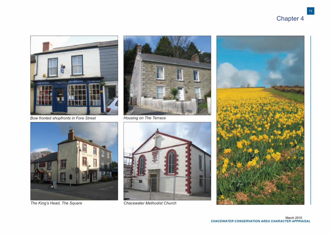
Bow fronted shopfronts in Fore Street Housing on The Terrace
The King’s Head, The Square Chacewater Methodist Church
11
CHACEWATER CONSERVATION AREA CHARACTER APPRAISAL
Chacewater DTP.indd 11 10/12/2008 10:19:02
March 2010

LANDSCAPE CHARACTERChapter 5
CHACEWATER CONSERVATION AREA CHARACTER APPRAISAL
12
Chacewater DTP.indd 12 10/12/2008 10:19:02
March 2010
Chapter 5 LANDSCAPE CHARACTER
5.1 Landscape and settlement edges
5.1.1 The Countryside Agency’s Landscape Characterisation defines the area surrounding Chacewater as Cornish Killas with the following key characteristics:
• Undulating slate plateau with little woodland and few hedgerow trees
• Numerous broadleaved wooded valleys, varying greatly in size. Northern valleys generally narrow and densely wooded. In the south there are drowned valleys (rias) with wide estuaries
• Rugged coastal scenery. Exposed and windswept cliffs in the north with limited access to the sea, more sheltered and wooded in the south
• Outstanding historic parks, mainly in the sheltered valleys in the south
• Generally a dispersed settlement pattern of hamlets, farmsteads and small fishing villages
• Variable field pattern dominated by stone-built Cornish hedges
• Important archaeological and industrial-archaeological sites
5.1.2 The landscape surrounding Chacewater has been studied through the Cornwall Historic Landscape Characterisation, which defined smaller areas of landscape character, based on their historic development, their current appearance and use. This identifies the village as a 20th century settlement (perhaps in error), while the hillsides and valley to the north and north west are classed as post-medieval farmland with
some 20th century farmland. Medieval farmland is located to the south west of the village and on the hillsides to the east and north east, whilst further post-medieval farmland lies to the south-east and within the valley to the south.
5.1.3 Chacewater is very much contained by its surrounding landscape. The steeply sloping hillsides foreshorten views out of the village, whilst the east-west alignment of the main street and its compact development prevent views to the north or south along the Carnon Valley. The south, west and north settlement edges are well treed, further reducing views but providing them with a rural feel. The hillside to the east, beyond the post-war housing development, is more open drawing the eye out of the village over the gentle slope to the farmstead at Killiewheries Barton.
5.1.4 Immediately to the north and west of the conservation area, post-war housing mostly comprising bungalows, covers the floor and lower slope of the valley, while late 19th century housing, in-filled with modern housing, lies along the north side of The Terrace. Further to the west, a former walled garden has been developed with bungalows, although much of the garden wall has been retained. Beyond this, the landscape is formed of small fields mostly in permanent pasture as well as some small areas of woodland.
Jakes Lane and countryside beyondNorth Hill - one of many routes radiating from Chacewater
13
CHACEWATER CONSERVATION AREA CHARACTER APPRAISAL
Chacewater DTP.indd 13 10/12/2008 10:19:09
March 2010
5.1.5 The former industrial landscape of the Wheal Busy and Creegbrawse Mines further to the west and south west are hidden from view, although they are accessible via the narrow lanes and bridle paths that lead from the village into the countryside. The importance of this industrial landscape is reflected in its designation in the Local Plan as an Area of Great Historic Value.
5.1.6 To the north, Station Road leads out of the village along the narrow, steep sided valley which is heavily treed. The slopes of the hillside to the east of the village are covered by larger fields, more suited to arable cultivation than those to the west, although an interesting row of small fields, bounded by a narrow track, flank the road out of the village up Chacewater Hill. The post-war and modern housing developments to the east and south east of the conservation area break the connection between the historic village and the countryside.
5.1.7 To the south, access to the landscape of small fields and the Carnon Valley, which widens slightly at this point, is provided by Church Hill and Falmouth Road. The settlement pattern gradually loses cohesion and disperses into the countryside without a hard edge. Indeed it is difficult to define where the village ends along Falmouth Road or Church Hill. Elsewhere, the boundary between development and open fields is more distinct, although this happens to the west and southeast only after the intervention of modern development.
5.1.8 The Cornwall and West Devon Mining Landscape World Heritage Site covers all of the village and the land adjacent to it. The characterisation undertaken in support of the nomination of the World Heritage Site identified much of the post-medieval farmland surrounding Chacewater as former miners’ smallholdings, whilst the village itself was classified as a 19th century mining settlement.
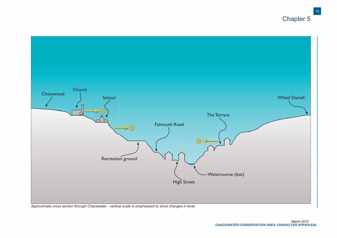
5.2 Topography
5.2.1 The village occupies the floor and sides of two valleys. One from the west joins the north-south Carnon Valley in the village centre. The valley sides are fairly steep, rising from approximately 45 metres above sea level in the village centre to over 100 metres on all sides. The valleys enclose the village preventing long vistas other than those along them as they curve gently out of view. Longer views are available where the streets follow the contours of the hills or run along the valley floor, whilst the development of buildings up the sides of the valleys creates
interesting roofscapes in views across the valleys from the higher ground. The Church of St Paul stands out in particular as a result of its isolated position on the hillside overlooking the village.
5.2.2 The old toll road between Truro and Falmouth runs from east to west through the centre of the village and along the valley towards St Day. A distinctive feature is the number of lanes that radiate from the village confirming its historical relationship with its hinterland. Some follow the valley floors whilst others climb to the former hilltop industrial sites, such as Wheal Busy, Creegbrawse and Killifreth.
5.2.3 The Carnon River runs down the valley from the north, joining a smaller leat from the west near the village centre, and then continues to the south. The Truro-Redruth road crosses the River Carnon in the village centre.
5.2.4 The abundance of trees creates a sense of enclosure within the village, with panoramic views restricted to locations on higher ground in the outskirts of the village.
5.3 Geology
5.3.1 Chacewater lies within an area of upper Devonian sedimentary rocks, characterised as “predominantly sandstone and slates, with subordinate breccias” (Stapelton and Pethick in Ratcliffe, 1997), which are divided by glacial interfluves. These contain periglacial gravels, including ore bearing deposits. The presence of these minerals as alluvial deposits had an
Chapter 5
View across Chacewater from St Paul’s Churchyard
CHACEWATER CONSERVATION AREA CHARACTER APPRAISAL
14
Chacewater DTP.indd 14 10/12/2008 10:19:13
March 2010
Chapter 5
ChacewoodSchool
Falmouth Road
High Street
Watercourse (leat)
Wheal Daniell
Recreation ground
The Terrace
Church
vO
vO
vO
Approximate cross section through Chacewater - vertical scale is emphasised to show changes in level
15
CHACEWATER CONSERVATION AREA CHARACTER APPRAISAL
Chacewater DTP.indd 15 10/12/2008 10:19:13
March 2010
Chapter 5
important influence on the development of tin extraction through the streaming process and later mining activity.
5.3.2 The local building stone is the Middle Devonian Killas shale and slate, which is a semi-Metamorphic rubble stone with a light silvery grey colouring. It is not suited to fine work, so it is often covered with a lime render. Dressings for door and window openings tend to use granite or elvan stone, which are found as igneous intrusions among the Middle Devonian sedimentary rocks. Elvan was quarried nearby at Creegbrawse.
5.3.3 The killas is also poorly suited to making roofing slates. Slates were therefore traditionally imported from the Delabole quarry in north-west Cornwall where the younger carboniferous sedimentary rocks provide distinctively silvery grey slates.
5.4 Views and vistas
5.4.1 Viewed from outside, Chacewater is contained with the bowl of the Carnon Valley and the valley to the west, although this impression is slightly diminished by the sprawl of 20th century development up the hillside to the east. The view of the St. Paul’s Church across the conservation area from Chacewater Hill is particularly fine.
5.4.2 Views from within the village centre tend to be channelled along Fore Street and High Street, taking in the terraces of shops and houses on either side. Views out of the village centre along the streets leading off The Square and High Street
are largely blocked by the bends in the street and the surrounding buildings and trees.
5.4.3 The views across the conservation area, for instance from The Terrace, reveal the jumbled roofscape of the buildings below, in particular the banded slate on the roof of the Methodist Chapel. A similar impression is gained northwards from Falmouth Road. However, the numerous tall television aerials and satellite dishes on these roofs detract considerably from the value of this view.
5.5 Trees
5.5.1 The abundance of tall tree growth around the village is readily apparent and it makes an important contribution to framing views into the village.
5.5.2 Some self seeded trees along the banks of the stream in the east of the conservation area provide a background to buildings along High Street/Fore Street, although they may also detract from views across the conservation area.
5.5.3 Perhaps the most significant trees are the Monterey Pines surrounding the village recreation ground, which are echoed in the grounds of North Hill House across the valley. Trees also make an important contribution along the riverside to the north of the village centre and along the western side of Station Road where tall trees create drama on this route into and out of the village. There is also a line of conifers that provide a backdrop to the village car park.
Boundary wall of Killas stone
Roofscapes from The Terrace
Monterey Pines on Church Hill
CHACEWATER CONSERVATION AREA CHARACTER APPRAISAL
16
Chacewater DTP.indd 16 10/12/2008 10:19:25
March 2010
Chapter 5
5.6 Planting and green spaces
5.6.1 While the core of Chacewater is entirely built up, the buildings quickly give way to gardens and then the green landscape beyond. Indeed, a tall evergreen hedge runs along the south side of High Street at the western end of the village where it helps to continue the sense of enclosure. There are also green ‘fingers’ reaching into the village along the riverside or following the leat that leads in from the west.
5.6.2 In common with most settlements with a functional industrial history, there is no formal green space at the heart of Chacewater, in the sense of a village green. This makes the recreation ground on the south side of Falmouth Road, all the more important. The recreation ground was given to the people of Chacewater in 1925 by Lord Falmouth. More recently, Chacewater Parish Council has laid out the Millennium Green between Paul’s Church and the village hall. Extensive tree planting means that the field will play an important part in the succession of tree cover as it matures in future years.
5.7 Biodiversity
5.7.1 While there are no formal designations, such as Sites of Special Scientific Interest, in the vicinity of Chacewater, the village and its immediate surroundings provide a number of significant habitats. Two streams run through the village, which converge to form the upper reaches of the Carnon River, whilst numerous hedgerows delimit properties throughout the village. These are
increasingly rich in wildlife in the outer areas of the village where there is also a greater abundance of mature trees.
5.7.2 Farmland in the immediate vicinity of the village is largely permanent pasture, with areas of arable farming on the higher ground. The fields are divided by characteristic Cornish hedges, which support an abundance of wild plants and attendant wildlife.
5.7.3 Some invasive non-native plants including self seeding sycamores and, more worryingly, Japanese Knot Weed, are notable within the conservation area.
The Millennium Green behind the Village Hall Wild flowers in dry stone wall
17
CHACEWATER CONSERVATION AREA CHARACTER APPRAISAL
Chacewater DTP.indd 17 10/12/2008 10:19:37
March 2010

SPATIAL ANALYSISChapter 6
CHACEWATER CONSERVATION AREA CHARACTER APPRAISAL
18
Chacewater DTP.indd 18 10/12/2008 10:19:37
March 2010
Chapter 6 SPATIAL ANALYSIS
6.1 Layout and spaces
6.1.1 Chacewater’s layout has been influenced by a range of factors, including the line of the toll road and other routes radiating from the settlement, the shapes of the valleys, courses of rivers and streams and the location and nature of industrial activities both within and outside the settlement. The layout of streets, property boundaries and buildings has developed in response to these various influences resulting in a plan that includes several apparently unrelated elements.
6.1.2 Chacewater’s busy main street – The Square, Fore Street and High Street – retains the long linear form that is the result of the rapid 19th century development on the pre-existing 18th century turnpike road from Truro to Redruth. After the gently curving descent from Chacewater Hill, it follows a very straight course across the Carnon valley and to the west along the subsidiary valley towards Salem. Roads leading off this course provide access to areas to the north and south, which are of very different character.
6.1.3 To the north of the village centre the scramble of new development on the former Brewery site has been developed around a number of small culs-de-sac but retains the brewery’s former association with the course of the River Carnon. Station Road, connected the village with the former railway station to the north, whilst the late 19th century terrace to the west of it fills the space between the courses of the road and the riverside path which leads southward
to join Fore Street at the bridge over the River Carnon.
6.1.4 Outside the conservation area, former miners’ smallholdings are scattered along The Terrace, which provided a route to the mining area beyond the village, following the contour of the hillside with a long, straight road. Later, genteel housing on The Terrace perhaps reflects a desire to achieve a distance from the commercial area and public houses of the village centre.
6.1.5 To the south, Church Street, which runs uphill south-westwards from The Square, links the village centre to the Creegbrawse mining area just over a kilometre to the south west. It is linked back to the High Street by Falmouth Road exposing the backs of the High Street properties. Falmouth Road continues as a minor route following the river downstream to Wheal Prosper and the mines at Twelveheads.
One of the many radial routes
The straight line of Fore Street
The Terrace following the upper contour
19
CHACEWATER CONSERVATION AREA CHARACTER APPRAISAL
Chacewater DTP.indd 19 10/12/2008 10:19:47
March 2010
Chapter 6
6.2 Relationship of buildings to spaces
6.2.1 In the centre of the village the buildings are either built at the back of the pavement or, occasionally, with very narrow intervening gardens. The buildings along High Street are clearly planned as terraces, while Fore Street is more piecemeal. Their long, low blocks and the uniformity of their construction give the area a definite urban feel with a strong sense of enclosure.
6.2.2 There are, however, some significant gaps:
• To the right of the Rambling Miner PH• Between Nos.20&22 High Street where No.21
is set back• Between Nos.40&42 Fore Street where the
former smithy is set back• The forecourt of the Kings Head PH• Either side of Nos.17/18 High Street
6.2.3 Few of the buildings on Fore Street have significant plots to the rear although those on the north side of High Street have longer narrow plots extending down to the leat. The houses within the planned terraces have narrow frontages, while many of the buildings along Fore Street, which may be earlier, have relatively broad frontages better suited to their current or former use as shop premises. The planned, straight and uniform frontages channel views along the street to the land beyond or towards the slight opening out of the The Square.
6.2.4 The buildings surrounding the Square are also built directly behind the pavement giving definition to this small area of open space with their broad frontages. They include some of the village’s grander buildings including Nos.2 and 3 The Square, The King’s Head public house with Nos.6 and 7 The Square, and also the former Market (now sunny corner Nurseries). Together they provide a sense of the centre of the village. 6.2.5 Outside the village centre, at the western end of High Street, the buildings become more dispersed. The Rambling Miner Inn forms part of a short terrace built up against the pavement, but the buildings to the west of this are either set back or have sufficient foliage around them to provide an element of increased privacy. To the east, as the road climbs Chacewater Hill, gaps in the street frontage are created by lanes leading away from the road, yards and some larger gardens.
6.2.6 Along Station Road and around the bend to Riverside, both the modern and older buildings, including the Methodist Chapel, are built around yards or culs-de-sac, which create open areas on both sides of the street. The terraced cottages at Riverside appear to relate to Station Road but in fact are constructed well below the road with their primary frontages facing east. A narrow pavement runs along the front of several of them, with long narrow gardens extending eastwards. The northern part of the terrace is more private with access through each garden from the riverside path. To the north of the row is a group of three larger detached houses and a semi-detached pair of cottages (previously a single dwelling
but subdivided in the 20th century). They are scattered among large gardens and have a rural character, very unlike the village centre.
No.21 High Street set back from the frontage
Jakes Lane
CHACEWATER CONSERVATION AREA CHARACTER APPRAISAL
20
Chacewater DTP.indd 20 10/12/2008 10:19:51
March 2010
Chapter 6
6.2.7 Several small side streets, including East Bridge, Jake’s Lane and the southern part of Riverside, lead away from the main street into narrow, well enclosed spaces. Chacewater Primary School, further to the south, is hidden away by the tall trees growing on the west side of Church Street and is set back from the street with a stone wall defining the play ground to the front.
6.3 Landmarks, focal points and connections
6.3.1 Within the conservation area, the Passmore Edwards Literary Institute in Fore Street and the recently repainted Methodist Chapel in Station Road are the main landmarks. The red and white frontage of the chapel and its great expanse of roof make it identifiable from a great distance and it stands out in views from Falmouth Road to the south and The Terrace to the north. On the hillside to the south of the conservation area, the Church of St Paul is a more widely perceived landmark, which was clearly sited to make the most of its landscape setting.
6.3.2 The Square and a portion of Fore Street either side of it act as the main focal point of the village. The village’s remaining shops are grouped within this area and all of the main routes into the village converge at this point.
6.3.3 Other focal points include junction of Fore Street and Kerley Hill Road, where the recently rebuilt garden wall defines the street corner and views to this point from the west are stopped by the elevated siting of Roseland House. Views westwards along Fore Street are punctuated by
the former shop at No.20, which appears to jut out because No.21 is set back.
6.3.4 The streets and spaces within the conservation area are closely connected by a system of narrow lanes and alleys which supplement the main routes. Jake’s Lane is typical of this. Ironically, however, the interconnection is less prevalent in the centre of the village where the planned terraces prevent access from the main frontage to spaces to the rear.
St Paul’s Church Tower
The Square is the focus of the Village
21
CHACEWATER CONSERVATION AREA CHARACTER APPRAISAL
Chacewater DTP.indd 21 10/12/2008 10:19:57
March 2010

STREETSCAPE CHARACTERChapter 7
CHACEWATER CONSERVATION AREA CHARACTER APPRAISAL
22
Chacewater DTP.indd 22 10/12/2008 10:19:57
March 2010
Chapter 7 STREETSCAPE CHARACTER
7.1 Public space
7.1.1 Urban spaces occur more by good fortune than design. They include The Square and the forecourts of the King’s Head, the Methodist church and the former smithy (now the launderette).
7.1.2 The more formal public open spaces within the village are located to the south of the main spine. They include the car park, which was formerly a recreation ground, the current large recreation ground and bowling green to the south west of Falmouth Road, the Millennium Green, to the east of Church Street and the extensive churchyard beyond it. The latter two are currently outside the conservation area boundary.
7.2 Signage and street furniture
7.2.1 Street signs are generally modern with the exception of the listed milestone in Fore Street that reads ‘Truro 5 miles’. Street furniture, in the form of telephone kiosks, bus shelters and grit bins, is equally modern but sparingly used. In the car park, the lack of co-ordination of signage is evident. In some parts, such as Chacewater Hill, the poles and wirescape of electricity distribution are positively intrusive.
7.3 Lighting 7.3.1 The village was not lit in the past, so there is no historical precedent for street lighting. Light fittings were introduced as attachments to the wooden poles that distribute electricity. Some of these survive, but recently the centre of the village has been lit using plain swan-necked lanterns on independent modern columns with cast bases. In the peripheral areas, lighting is provided by more utilitarian downlighters on steel columns.Space beside the King’s Head Public House
The car park
23
CHACEWATER CONSERVATION AREA CHARACTER APPRAISAL
Chacewater DTP.indd 23 10/12/2008 10:20:04
March 2010
Chapter 7
7.4 Paving
7.4.1 The public realm in Chacewater reflects its rural setting and simplicity. Historically, street surfaces were no more than rammed earth and stone until the mid-20th century when tarmac was introduced. Now, tarmac and concrete kerbs are almost universal, but there is some surviving evidence for the use of stone. Indeed, the CISI report suggests that an example of an original metalled surface still survives on North Hill just outside the conservation area.
7.4.2 Where pavements existed, they had stone kerbs and a surface of rammed stone, cobbles or granite slabs. Until responsibility was assumed by local government in the mid-19th century, paving was maintained by the frontagers and standards varied. For instance, the semi-circular granite slab outside the shop doorway on the return side of No.27 Fore Street was evidently set into the street, which was later formalised with a narrow pavement and granite kerb. In contrast, the rectangular slab outside the Baker’s shop at No.4 Fore Street is likely to have been part of a wider scheme of paving such as those that still exist outside the Britannia Hotel on Fore Street and the King’s Head in The Square.
7.4.3 Cobbles tend to be irregular river cobbles, although it is possible that beach cobbles were imported as a return cargo for the copper ore transporters. Setting out lines can still be seen in the cobbled surface at No.2 The Square. Cobbles also survive on the east side of The Square and on Wheal Busy Lane. Further examples may survive beneath later tarmac.
Doorstep at 27 Fore Street Doorstep at The Bakery, Fore Street
Cobbles in The Square Granite paving, Fore Street
CHACEWATER CONSERVATION AREA CHARACTER APPRAISAL
24
Chacewater DTP.indd 24 10/12/2008 10:20:17
March 2010
Chapter 7
7.5 Boundary treatments
7.5.1 Boundaries tend to be defined by low walls of local killas rubble or Cornish hedges enclosing domestic gardens or former fields.
7.5.2 Granite was used for post and rail fencing on Station Road at Riverside Terrace and beside the village car park. It was also suited for elegant gate piers, as at Woodside or Roseland House. The corner of Station Road at No.28 Fore Street is also protected by a granite rubbing stone.
7.6 Traffic and parking 7.6.1 Traffic is very heavy through the centre of the village along High Street, Fore Street and the Square. This is particularly the case at peak commuting times as Chacewater is used as a short cut alternative to the A30/A390 route between Redruth and Truro. The road also serves as a busy bus route to and from Truro. The village does not have a controlled crossing and the traffic creates difficulties especially for older people crossing the road.
7.6.2 There is a demand for on-street parking on Fore Street/High Street to maintain the vitality of the shops. This has the useful side-effect of traffic calming, but it also increases congestion as parts of the street are effectively reduced to a single track. Yellow line markings in areas of restricted parking are not well maintained and this said to have hampered the ability to control problem parking.
7.6.3 Traffic speeds are also problematic through the main street, with drivers accelerating to climb Chacewater Hill or failing to slow down at the entry points to the village. Outside the village centre, traffic is a less significant problem. The village centre car park provides an amenity for residents and visitors and is also an important resource for local businesses. The car park surface is in need of renewal, although this is awaiting planned excavations for cable laying.
7.6.4 On-street parking is in demand along Station Road, for Riverside Terrace. There is also some problem with movement of heavy vehicles along Station Road despite the weight restriction.
7.7 Pedestrians and movement 7.7.1 A network of footpaths supplements the main routes through the village. Notable among these is Riverside, which follows the Carnon from Fore Street to the north of the conservation area crossing the river on a distinctive bridge formed of two massive granite beams with simple iron handrails.
7.7.2 Other paths link High Street with The Terrace and East Bridge with the village car park. Notable too are the radial paths that lead out into the countryside often as ‘hollow lanes’ between Cornish hedges. These connections are important reminders of Chacewater’s historical relationship with its hinterland.
Riverside path and footbridge
Granite post and rail fence, Church Hill
Hollow Lane
25
CHACEWATER CONSERVATION AREA CHARACTER APPRAISAL
Chacewater DTP.indd 25 10/12/2008 10:20:28
March 2010
THE BUILDINGS OF THE CONSERVATION AREAChapter 8
CHACEWATER CONSERVATION AREA CHARACTER APPRAISAL
26
Chacewater DTP.indd 26 10/12/2008 10:20:28
March 2010
Chapter 8 THE BUILDINGS OF THE CONSERVATION AREA
8.1 Building types
8.1.1 The historic buildings in the conservation area are typical of a small settlement with a variety of uses, resulting in a range of architectural styles, building form, details and materials. Surprisingly, the surviving buildings provide few obvious links to the mines and metal processing works which once took place both in the village and on its outskirts. The early 19th century maps show squatters’ cottages, smallholdings and industrial buildings which surrounded the tin streaming sites that focussed on the river and bridge. However, from the 1820s the principal landowners, the Tregothnan Estate, began adding more houses along the main road, as well as the church, built on the outskirts of the settlement perhaps because of the industrial activity in the village centre. This created the densely packed houses along High Street and Fore Street which we see today and which provide a strong urban character.
8.1.2 As a result, Chacewater retains a splendid, though late, church; a fine former rectory and village school; a former market hall; a Masonic Lodge; the Edward J. Passmore Literary Institute (recently converted for housing); two chapels; and a variety of mainly terraced houses and shops, some arranged in well ordered and matching terraces, some more individual. It appears that only two squatter’s cottages still remain, one in Kerley Hill and one on The Terrace. A new village hall on Church Hill is a popular and well used local facility.
8.1.3 The late 19th century parish church (St Paul’s) is the largest and most prestigious building, although it is currently outside the conservation area. Close by, and also outside the boundary, is Chacewater House, the former rectory and the highest status house in the village. Within the conservation area boundary, but not far away from the church, Chacewater Primary School provides educational facilities for the local children. Otherwise, the remaining buildings are mainly in residential uses, with several along Fore Street and High Street (the commercial ‘core’ of the village) retaining ground floor shops. In addition, there are three public houses – the King’s Head, the Britannia, and the Rambling Miner – all in Fore Street or High Street. A former chapel in Fore Street has now been converted into residential accommodation, but another 19th century chapel remains in Station Road and is still in use. The early 19th century former market building in The Square was rebuilt in the 1970s and is now a nursery and garden centre.
8.1.4 Many of the buildings are in residential uses but pleasingly the settlement retains the more varied character of a commercially and socially active village with mixed uses that provide a range of different buildings. In the 1960s John Betjeman described Chacewater as…”well built colour-washed cottages….bow-windowed Georgian shops… and up the valley slopes the tidy villas built in the last century by tin mine captains”. These remain the defining building types in the village, although some have regrettably been spoilt by modern alterations and extensions.
Houses in High Street
The Rambling Miner
27
CHACEWATER CONSERVATION AREA CHARACTER APPRAISAL
Chacewater DTP.indd 27 10/12/2008 10:20:34
March 2010
Chapter 8
8.2 Building form
8.2.1 The historic buildings of Chacewater are mainly grouped in terraces in the commercial core of the village, particularly along Fore Street, High Street and The Square, where most of the buildings are listed and a more urban character is prevalent. Some of these terraces, such as Nos.1-5 and Nos.14-19, were built as single developments confirming that they form part of the more planned streetscape. Other buildings have individual details, although they might share a common building line and a similar eaves or ridge height. These buildings tend to sit tight on the back of the pavement with few front gardens or yards.
8.2.2 Further out, the buildings tend to be detached or arranged in pairs, with more spacious gardens. Another long terrace of cottages runs up Station Road, and shorter terraces can also be seen at the eastern end of Fore Street towards the edges of the conservation area where a more informal rural character predominates.
8.2.3 The principal features of the built form of the High Street/Fore Street area are:
• Urban character with some examples of planned development
• Cohesive qualities with mainly listed two storey terraced houses, dating to the 18th and 19th centuries
• Buildings mainly arranged in terraces, with a common building line on the back of the pavement
• Shallow pitched roofs covered in slate, corrugated asbestos or artificial slate, facing the road
• Roofs have similar ridge and eaves height, but there is variety, with some buildings having hipped ends
• Short brick axial stacks, simply detailed• Plain ridges and eaves details• Few rooflights or dormers, leaving roofs
uninterrupted• Use of elvan stone, granite, and killas rubble
stone, which is sometimes rendered or painted• Some stucco/render on concealed timber
studwork• Simple rectangular shapes, usually flat fronted
but with some historic shopfronts, either flat or bow fronted;
• Mainly sash windows, some retaining their original glazing pattern and divided into small panes;
• Nos. 33 and 34, and 39 and 40, Fore Street are taller, more prestigious properties, which were designed as stand-alone houses with hipped roofs
• The use of local stone, and the variety of sash windows and shopfronts, all add interest
8.3 Building uses
8.3.1 Historically, Chacewater has supported the range of uses that define a commercial centre. However, this variety has been reduced in modern times by the demolition of industrial buildings, such as the stamping mills and the brewery, and by the conversion of others, such as the literary institute, into domestic use. The former smithy, near the bridge in Fore Street, is now the launderette.
8.3.2 While most property is now residential, the houses are still served by a range of shops, a church, a chapel, a school, three public houses, a nursery garden and, most recently, by the parish council’s Millennium Hall.
Nos.39 and 40 Fore Street Chapel converted to housing
CHACEWATER CONSERVATION AREA CHARACTER APPRAISAL
28
Chacewater DTP.indd 28 10/12/2008 10:20:40
March 2010
Chapter 8
8.4 Listed buildings
8.4.1 There are 47 listed buildings or structures within the Chacewater Conservation Area, all of them listed grade II. These include Chacewater Primary School, and the public houses as well as a number of houses and shops. In addition to buildings, the early 19th century bridge that carries Fore Street over the Carnon is also listed grade II, as are the village watering place in East Bridge and the milestone in Fore Street.
8.4.2 The parish church of St Paul, its lychgate, and its adjoining former rectory, are also listed (grade II) but currently lie outside the conservation area. Because of this, the largest and most dominant of the listed buildings in the conservation area is Chacewater Primary School, built as a National School in 1846 and enlarged in 1878 and again in 1897. This building is notable for its use of local materials including the elvan ashlar blocks to the principal elevation, with granite dressings,
which provide a finely detailed frontage to the street. The school, church and former rectory form a group, which will be more obvious once the conservation area boundary is extended as discussed in the Management Plan.
8.4.3 Otherwise, the listed buildings are all located in High Street and Fore Street, where they form an almost continuous group on both sides of the street. The highest status building is Woodside, the only truly detached listed house which is located on the south side of High Street in a large garden. This dates from the 18th century but has been altered and extended in the late 19th century. Its very fine elvan stone front elevation, arranged symmetrically with five windows to the first floor, surprisingly has an off-centre front door, possibly because it was originally two properties. This must be one of the houses of the ‘tin mine captains’ referred to by John Betjeman.
8.4.4 The listed buildings are shown on the Townscape Appraisal Map at Appendix 2.
Chacewater Village Hall
East Bridge: The watering place Lychgate at St Paul’s Church
29
CHACEWATER CONSERVATION AREA CHARACTER APPRAISAL
Chacewater DTP.indd 29 10/12/2008 10:20:50
March 2010