Embed Size (px)
Citation preview

i
Contents Introduction............................................................................................................................. 3
1. Site description .................................................................................................................... 3
2. Instrumentation.................................................................................................................... 4
2.1. Tacheometers, EDMI, Theodolites ............................................................................. 4
2.1.1. Description ......................................................................................................... 4
2.1.2 Calibrations ......................................................................................................... 5
2.1.3 Auxiliary Equipment............................................................................................ 5
2.2 GPS units ................................................................................................................... 5
2.2.1 Receivers............................................................................................................. 5
2.2.2 Antennas ............................................................................................................. 5
2.2.3 Analysis software, mode of operation ................................................................... 5
2.3 Leveling..................................................................................................................... 5
2.3.1 Leveling instruments............................................................................................ 5
2.3.2 Leveling rods....................................................................................................... 5
2.4 Tripods ...................................................................................................................... 6
2.5 Forced centering devices............................................................................................. 7
2.6 Targets, reflectors....................................................................................................... 8
3. Measurement Setup ............................................................................................................. 8
3.1 Ground network ......................................................................................................... 8
3.1.1 Listing ................................................................................................................10
3.1.2 Map of Network .................................................................................................14
3.2 Representation of Technique Reference Points ...........................................................15
3.2.1 VLBI/VLBA ......................................................................................................15
3.2.2 SLR....................................................................................................................16
3.2.3 GPS....................................................................................................................17
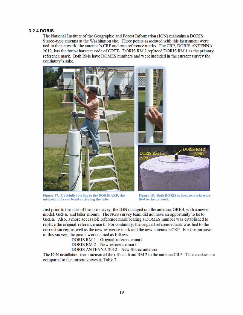
3.2.4 DORIS ...............................................................................................................19
3.2.5 GLONASS (N/A) ...............................................................................................20
4. Observations.......................................................................................................................20
4.1 Conventional Survey .................................................................................................20
4.2 Leveling....................................................................................................................20
4.3 GPS ..........................................................................................................................20
4.4 General Comments ....................................................................................................21
ii
5. Data Analysis and Results ...................................................................................................22
5.1 Terrestrial Survey ......................................................................................................22
5.1.1 Analysis software ...............................................................................................22
5.1.2 Topocentric coordinates and covariance...............................................................23
5.1.3 Correlation matrix...............................................................................................23
5.1.4 Reference temperature of radio telescopes [for thermal expansion] .......................23
5.2 GPS Observations .....................................................................................................24
5.2.1 Analysis Software ...............................................................................................24
5.2.2 Results ...............................................................................................................25
5.3 Additional Parameters ...............................................................................................26
5.4 Transformation..........................................................................................................26
5.5 Description of SINEX generation...............................................................................27
5.6 Discussion of Results ................................................................................................28
5.7 Comparison with Previous Surveys ............................................................................33
6. Planning Aspects ................................................................................................................35
7. References..........................................................................................................................35
7.1 Name of person responsible for observations ..............................................................35
7.2 Name of person(s) responsible for analysis.................................................................35
7.3 Location of observation data and results archive .........................................................36
ATTACHMENTS...........................................................................................................37
A. GPS Geocentric Coordinates and Covariances........................................................37
B. SINEX File NGSWASH0712GA.snx.....................................................................45
C. IERS ITRS Product Center SINEX File (retrieval) .................................................58
3
Introduction In the spirit of scientific cooperation, the U.S. National Oceanic and Atmospheric Administration’s (NOAA) National Geodetic Survey (NGS) contributes to future realizations of the International Terrestrial Reference Frame (ITRF) by providing the International Earth Rotation and Reference Systems Service (IERS) with local tie information for geodetic techniques co-located at IERS Network Sites considered a priority by that service. Within NOAA, these types of surveys are the responsibility of the NGS’s IERS Site Survey (ISS) program.
During June, July and August of 2012, the NGS ISS program conducted a local tie vector survey at IERS network site WASHINGTON. Eight space geodetic technique instruments are co-located at this site, consisting of two very long baseline interferometry (VLBI) radio telescopes, two satellite laser ranging (SLR) systems and three GNSS antennas, all owned by the U.S. National Aeronautics and Space Administration (NASA). Prior to the survey, the French National Institute of Geographic and Forest Information (IGN) installed a new Doppler Orbitography and Radiopositioning Integrated by Satellite (DORIS) antenna, replacing GREB (DOMES# 40451S176).
This report documents the instrumentation, procedures, data analysis, and local tie information results associated with this survey.
1. Site description IERS network site WASHINGTON is located in the United States of America at NASA’s Goddard Geophysical and Astronomic Observatory (GGAO), , near the town of Greenbelt, MD. Eight instruments representing four space geodetic techniques are co-located at this site.
4
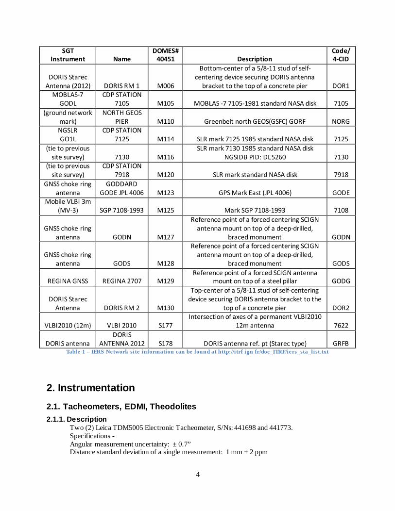
SGT Instrument Name
DOMES# 40451 Description
Code/ 4-CID
DORIS Starec Antenna (2012) DORIS RM 1 M006
Bottom-center of a 5/8-11 stud of self-centering device securing DORIS antenna
bracket to the top of a concrete pier DOR1 MOBLAS-7
GODL CDP STATION
7105 M105 MOBLAS -7 7105-1981 standard NASA disk 7105 (ground network
mark) NORTH GEOS
PIER M110 Greenbelt north GEOS(GSFC) GORF NORG NGSLR GO1L
CDP STATION 7125 M114 SLR mark 7125 1985 standard NASA disk 7125
(tie to previous site survey) 7130 M116
SLR mark 7130 1985 standard NASA disk NGSIDB PID: DE5260 7130
(tie to previous site survey)
CDP STATION 7918 M120 SLR mark standard NASA disk 7918
GNSS choke ring antenna
GODDARD GODE JPL 4006 M123 GPS Mark East (JPL 4006) GODE
Mobile VLBI 3m (MV-3) SGP 7108-1993 M125 Mark SGP 7108-1993 7108
GNSS choke ring antenna GODN M127
Reference point of a forced centering SCIGN antenna mount on top of a deep-drilled,
braced monument GODN
GNSS choke ring antenna GODS M128
Reference point of a forced centering SCIGN antenna mount on top of a deep-drilled,
braced monument GODS
REGINA GNSS REGINA 2707 M129 Reference point of a forced SCIGN antenna
mount on top of a steel pillar GODG
DORIS Starec Antenna DORIS RM 2 M130
Top-center of a 5/8-11 stud of self-centering device securing DORIS antenna bracket to the
top of a concrete pier DOR2
VLBI2010 (12m) VLBI 2010 S177 Intersection of axes of a permanent VLBI2010
12m antenna 7622
DORIS antenna DORIS
ANTENNA 2012 S178 DORIS antenna ref. pt (Starec type) GRFB Table 1 – IERS Network site information can be found at http://itrf ign fr/doc_ITRF/iers_sta_list.txt
2. Instrumentation
2.1. Tacheometers, EDMI, Theodolites 2.1.1. Description
Two (2) Leica TDM5005 Electronic Tacheometer, S/Ns: 441698 and 441773. Specifications - Angular measurement uncertainty: ± 0.7” Distance standard deviation of a single measurement: 1 mm + 2 ppm
5
2.1.2 Calibrations Instruments calibrated by , Switzerland. Inspection date: 08/15/2008 / 08/20/2008 Both instruments were found to be within factory specifications (see Attachment A).
2.1.3 Auxiliary Equipment Wild NL4 Collimator, S/N: 40145 pointing accuracy, 1: 200,000 Thermometer/hygrometer: Omega RH83, checked against thermistors maintained at the Instrumentation and Methodologies Branch (IMB) of NGS’s Geodetic Services Division (GSD). Barometer: Leitz AIR-HB-1L, S/N: 1L1890
2.2 GPS units 2.2.1 Receivers Four (4) Trimble NetR5 GPS L1 C/A Code, L2C, L1/L2/L51 Full Cycle Carrier, GLONASS L1 C/A Code, L1 P Code, L2 P Code, L1/L2 Full Cycle Carrier with Maxwell™ Custom Survey GNSS Chip. P/N: 62800-00, S/Ns: 4619K01307, 4624K01584, 4624K01631 and 4624K01648
Specifications for Static GPS Surveying: Horizontal: +/- 5 mm + 0.5 ppm RMS Vertical: +/- 5 mm + 1 ppm RMS
2.2.2 Antennas Four (4) TPSCR.G3, Topcon GPS/GLONASS/Galileo choke ring antenna, model CR-G3, P/N: 1-044301-01, S/Ns 383-1613, -1614, -1626 and -1628
2.2.3 Analysis software, mode of operation Post-processing and adjustment were undertaken using NGS’s beta version of Online Positioning User Service (OPUS) Projects, an interactive web page. Data is tagged with a project identifier and on the OPUS web page and uploaded normally. OPUS Projects sorts the data into sessions. User must log in, select a session and reconfigure it if desired before starting the processing. Processing reports are generated and interactive tables display a summary of results. Processed base lines are made available for the adjustment phase. The user is allowed limited flexibility in setting adjustment parameters. Processing and adjustment results are automatically forwarded to user via email.
2.3 Leveling 2.3.1 Leveling instruments
Leica DNA03 digital level, P/N: 723289, S/N: 332228. Height measurement accuracy, +/-0.3 mm per km, double-run.
2.3.2 Leveling rods Single-piece Leica 2-meter invar rod, P/N: 563660 S/N: 30721
2.3.3 Checks carried out before measurements Daily instrument collimation test procedures were undertaken on-site prior to data collection. Leveling rod bubbles were checked daily, prior to use.
6
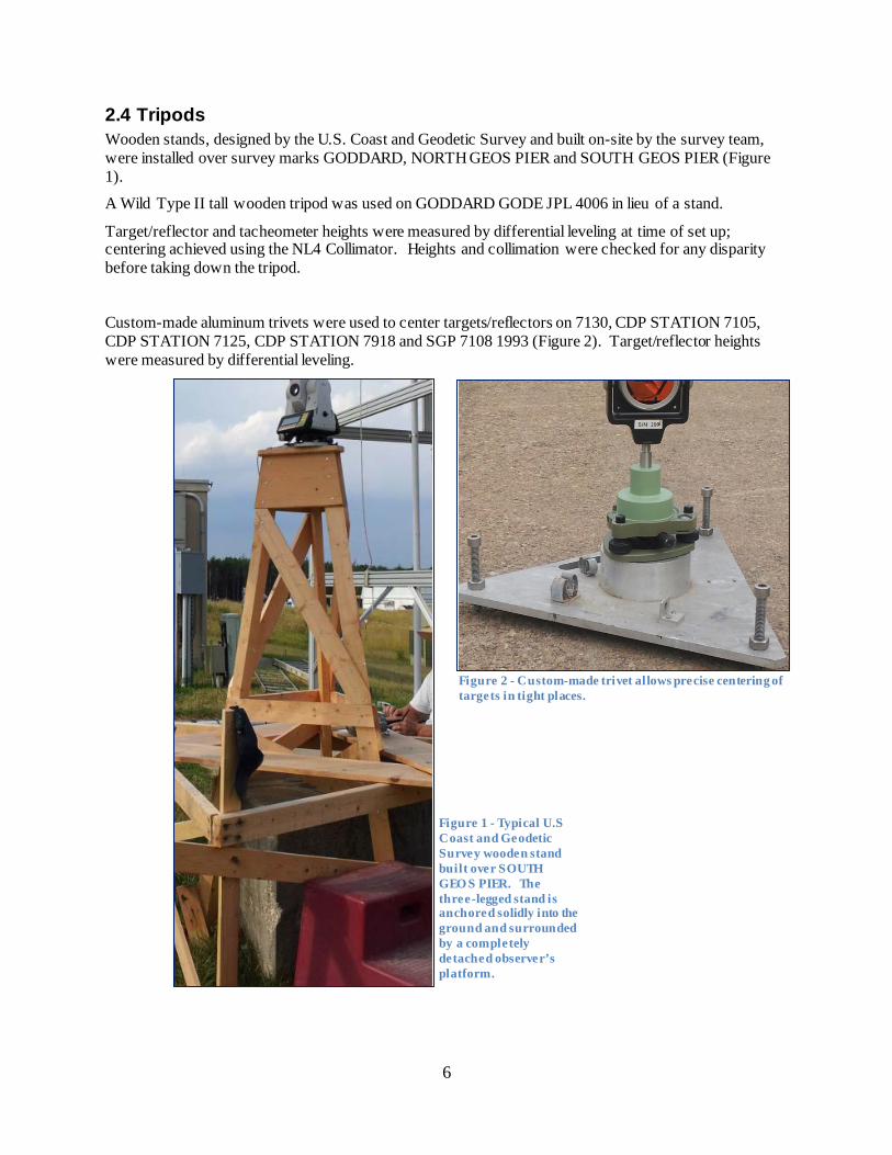
2.4 Tripods Wooden stands, designed by the U.S. Coast and Geodetic Survey and built on-site by the survey team, were installed over survey marks GODDARD, NORTH GEOS PIER and SOUTH GEOS PIER (Figure 1).
A Wild Type II tall wooden tripod was used on GODDARD GODE JPL 4006 in lieu of a stand.
Target/reflector and tacheometer heights were measured by differential leveling at time of set up; centering achieved using the NL4 Collimator. Heights and collimation were checked for any disparity before taking down the tripod.
Custom-made aluminum trivets were used to center targets/reflectors on 7130, CDP STATION 7105, CDP STATION 7125, CDP STATION 7918 and SGP 7108 1993 (Figure 2). Target/reflector heights were measured by differential leveling.
Figure 1 - Typical U.S Coast and Geodetic Survey wooden stand built over SOUTH GEO S PIER. The three-legged stand is anchored solidly into the ground and surrounded by a completely detached observer’s platform.
Figure 2 - Custom-made trivet allows precise centering of targets in tight places.
7
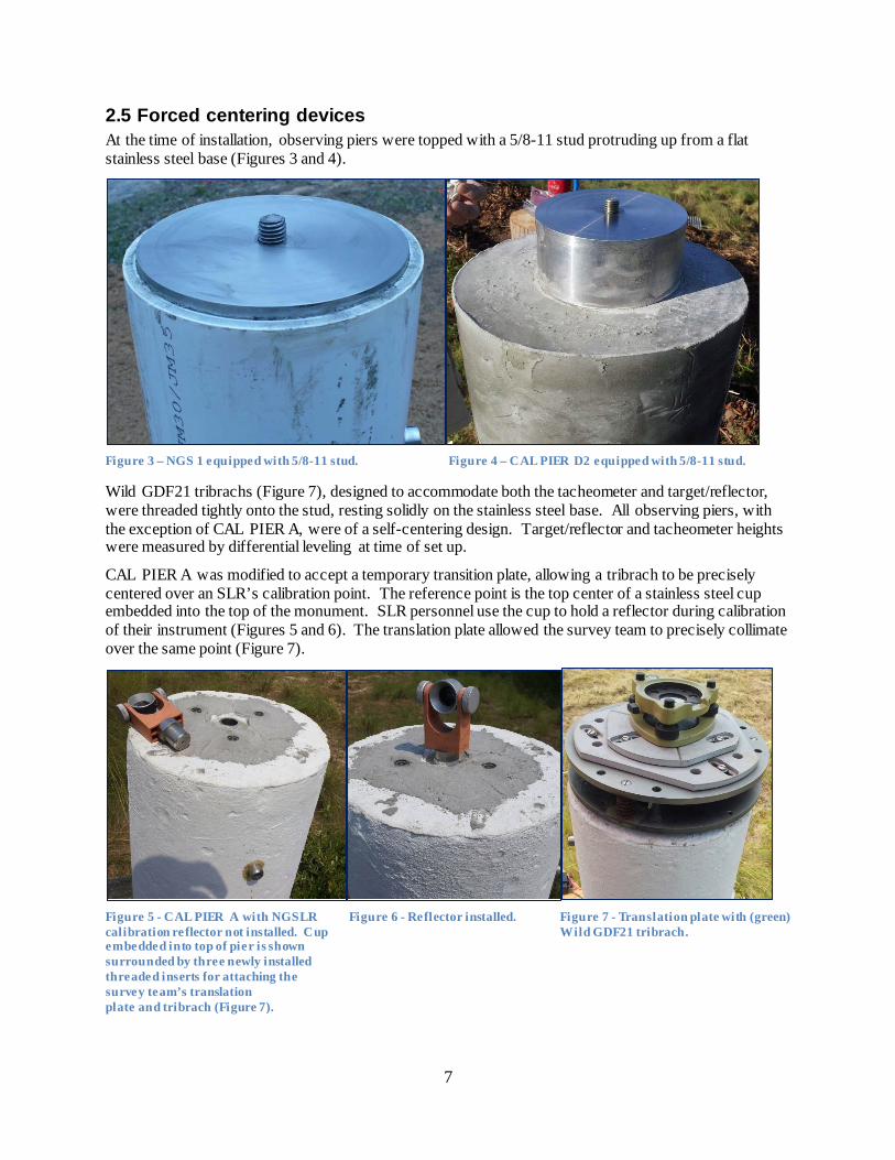
2.5 Forced centering devices At the time of installation, observing piers were topped with a 5/8-11 stud protruding up from a flat stainless steel base (Figures 3 and 4).
Figure 3 – NGS 1 equipped with 5/8-11 stud. Figure 4 – CAL PIER D2 equipped with 5/8-11 stud.
Wild GDF21 tribrachs (Figure 7), designed to accommodate both the tacheometer and target/reflector, were threaded tightly onto the stud, resting solidly on the stainless steel base. All observing piers, with the exception of CAL PIER A, were of a self-centering design. Target/reflector and tacheometer heights were measured by differential leveling at time of set up.
CAL PIER A was modified to accept a temporary transition plate, allowing a tribrach to be precisely centered over an SLR’s calibration point. The reference point is the top center of a stainless steel cup embedded into the top of the monument. SLR personnel use the cup to hold a reflector during calibration of their instrument (Figures 5 and 6). The translation plate allowed the survey team to precisely collimate over the same point (Figure 7).
Figure 5 - CAL PIER A with NGSLR Figure 6 - Reflector installed. Figure 7 - Translation plate with (green) calibration reflector not installed. Cup Wild GDF21 tribrach. embedded into top of pier is shown surrounded by three newly installed threaded inserts for attaching the survey team’s translation plate and tribrach (Figure 7).
8
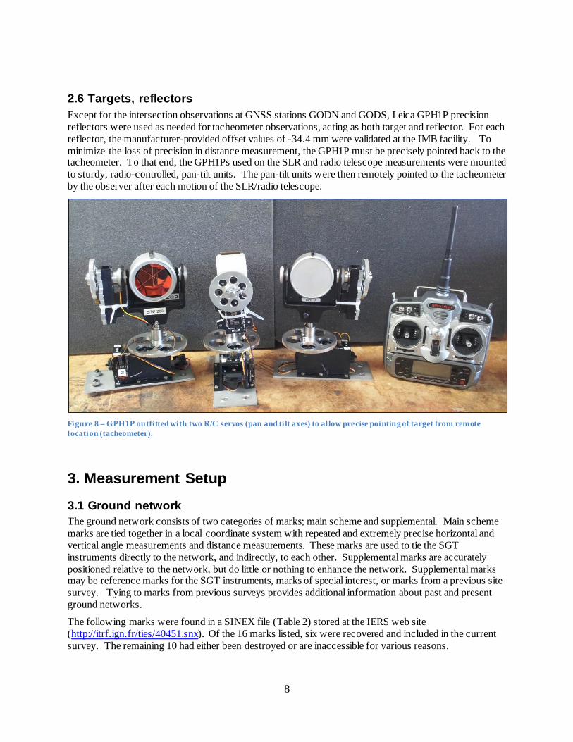
2.6 Targets, reflectors Except for the intersection observations at GNSS stations GODN and GODS, Leica GPH1P precision reflectors were used as needed for tacheometer observations, acting as both target and reflector. For each reflector, the manufacturer-provided offset values of -34.4 mm were validated at the IMB facility. To minimize the loss of precision in distance measurement, the GPH1P must be precisely pointed back to the tacheometer. To that end, the GPH1Ps used on the SLR and radio telescope measurements were mounted to sturdy, radio-controlled, pan-tilt units. The pan-tilt units were then remotely pointed to the tacheometer by the observer after each motion of the SLR/radio telescope.
Figure 8 – GPH1P outfitted with two R/C servos (pan and tilt axes) to allow precise pointing of target from remote location (tacheometer).
3. Measurement Setup
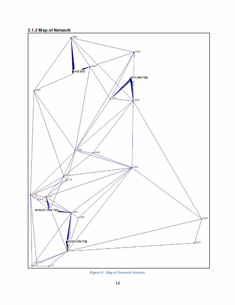
3.1 Ground network The ground network consists of two categories of marks; main scheme and supplemental. Main scheme marks are tied together in a local coordinate system with repeated and extremely precise horizontal and vertical angle measurements and distance measurements. These marks are used to tie the SGT instruments directly to the network, and indirectly, to each other. Supplemental marks are accurately positioned relative to the network, but do little or nothing to enhance the network. Supplemental marks may be reference marks for the SGT instruments, marks of special interest, or marks from a previous site survey. Tying to marks from previous surveys provides additional information about past and present ground networks.
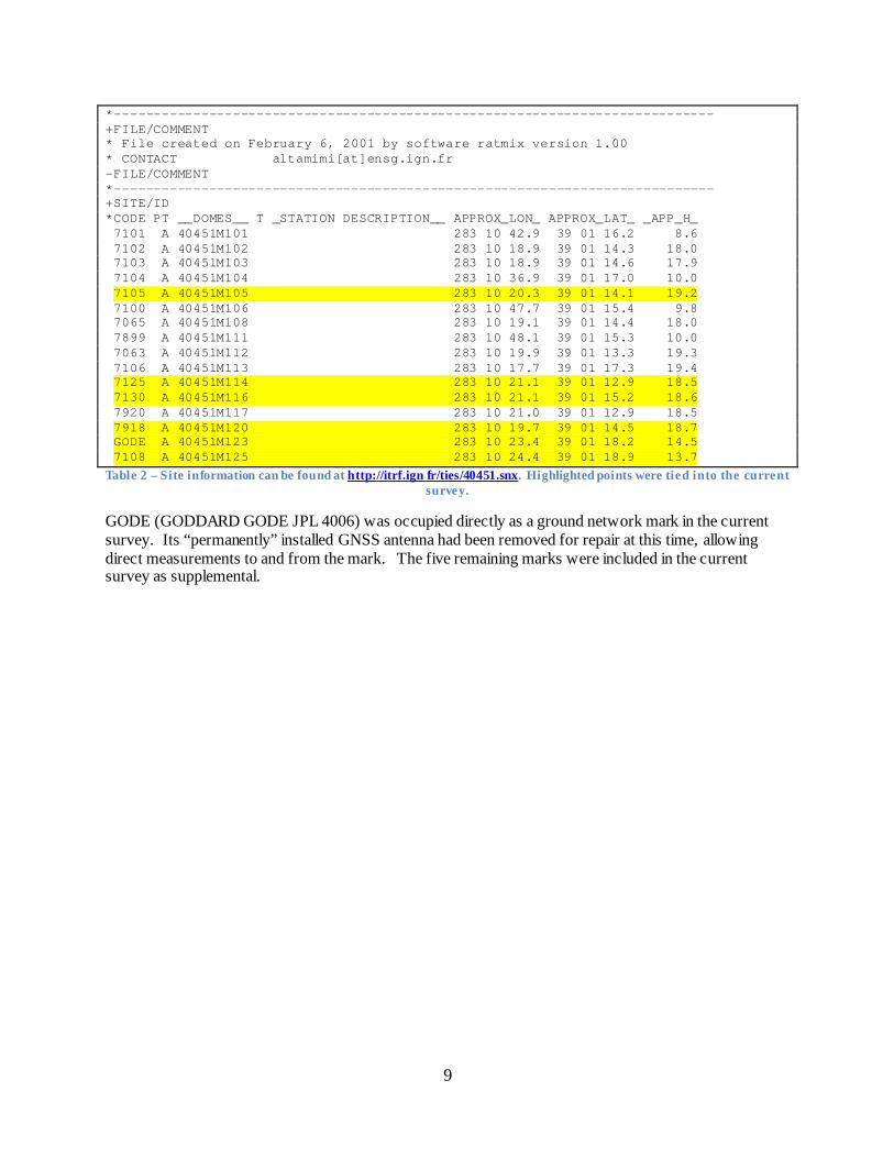
The following marks were found in a SINEX file (Table 2) stored at the IERS web site (http://itrf.ign.fr/ties/40451.snx). Of the 16 marks listed, six were recovered and included in the current survey. The remaining 10 had either been destroyed or are inaccessible for various reasons.
9
*---------------------------------------------------------------------------- +FILE/COMMENT * File created on February 6, 2001 by software ratmix version 1.00 * CONTACT altamimi[at]ensg.ign.fr -FILE/COMMENT *---------------------------------------------------------------------------- +SITE/ID *CODE PT __DOMES__ T _STATION DESCRIPTION__ APPROX_LON_ APPROX_LAT_ _APP_H_ 7101 A 40451M101 283 10 42.9 39 01 16.2 8.6 7102 A 40451M102 283 10 18.9 39 01 14.3 18.0 7103 A 40451M103 283 10 18.9 39 01 14.6 17.9 7104 A 40451M104 283 10 36.9 39 01 17.0 10.0 7105 A 40451M105 283 10 20.3 39 01 14.1 19.2 7100 A 40451M106 283 10 47.7 39 01 15.4 9.8 7065 A 40451M108 283 10 19.1 39 01 14.4 18.0 7899 A 40451M111 283 10 48.1 39 01 15.3 10.0 7063 A 40451M112 283 10 19.9 39 01 13.3 19.3 7106 A 40451M113 283 10 17.7 39 01 17.3 19.4 7125 A 40451M114 283 10 21.1 39 01 12.9 18.5 7130 A 40451M116 283 10 21.1 39 01 15.2 18.6 7920 A 40451M117 283 10 21.0 39 01 12.9 18.5 7918 A 40451M120 283 10 19.7 39 01 14.5 18.7 GODE A 40451M123 283 10 23.4 39 01 18.2 14.5 7108 A 40451M125 283 10 24.4 39 01 18.9 13.7
Table 2 – Site information can be found at http://itrf.ign fr/ties/40451.snx. Highlighted points were tied into the current survey.
GODE (GODDARD GODE JPL 4006) was occupied directly as a ground network mark in the current survey. Its “permanently” installed GNSS antenna had been removed for repair at this time, allowing direct measurements to and from the mark. The five remaining marks were included in the current survey as supplemental.
10
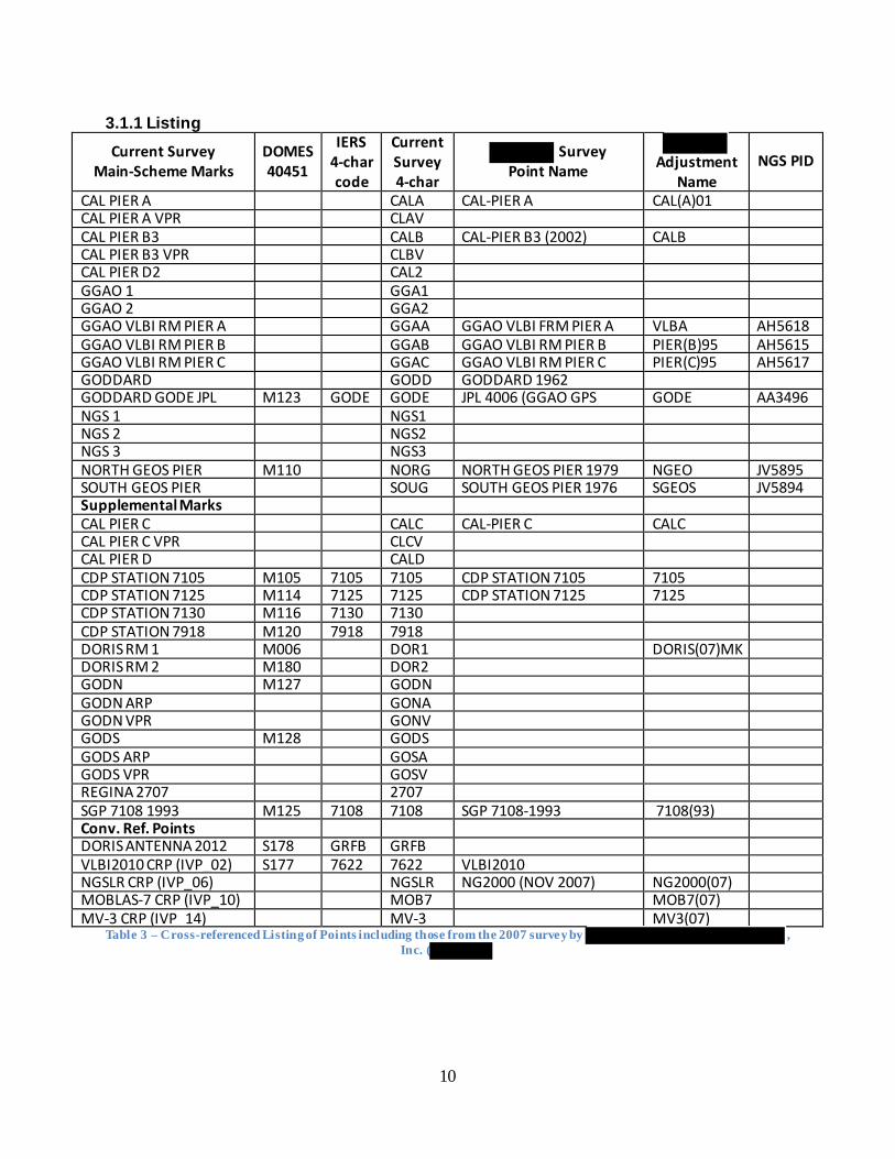
3.1.1 Listing Current Survey
Main-Scheme Marks DOMES 40451
IERS 4-char code
Current Survey 4-char
Survey Point Name
Adjustment
Name NGS PID
CAL PIER A CALA
CAL-PIER A CAL(A)01 CAL PIER A VPR CLAV CAL PIER B3 CALB CAL-PIER B3 (2002) CALB CAL PIER B3 VPR CLBV CAL PIER D2 CAL2 GGAO 1 GGA1 GGAO 2 GGA2 GGAO VLBI RM PIER A GGAA GGAO VLBI FRM PIER A VLBA AH5618 GGAO VLBI RM PIER B GGAB GGAO VLBI RM PIER B PIER(B)95 AH5615 GGAO VLBI RM PIER C GGAC GGAO VLBI RM PIER C PIER(C)95 AH5617 GODDARD GODD GODDARD 1962 GODDARD GODE JPL
M123 GODE GODE JPL 4006 (GGAO GPS
GODE AA3496
NGS 1 NGS1 NGS 2 NGS2 NGS 3 NGS3 NORTH GEOS PIER M110 NORG NORTH GEOS PIER 1979 NGEO JV5895 SOUTH GEOS PIER SOUG SOUTH GEOS PIER 1976 SGEOS JV5894 Supplemental Marks CAL PIER C CALC CAL-PIER C CALC CAL PIER C VPR CLCV CAL PIER D CALD CDP STATION 7105 M105 7105 7105 CDP STATION 7105 7105 CDP STATION 7125 M114 7125 7125 CDP STATION 7125 7125 CDP STATION 7130 M116 7130 7130 CDP STATION 7918 M120 7918 7918 DORIS RM 1 M006 DOR1 DORIS(07)MK DORIS RM 2 M180 DOR2 GODN M127 GODN GODN ARP GONA GODN VPR GONV GODS M128 GODS GODS ARP GOSA GODS VPR GOSV REGINA 2707 2707 SGP 7108 1993 M125 7108 7108 SGP 7108-1993 7108(93) Conv. Ref. Points DORIS ANTENNA 2012 S178 GRFB GRFB VLBI2010 CRP (IVP_02) S177 7622 7622 VLBI2010 NGSLR CRP (IVP_06) NGSLR NG2000 (NOV 2007) NG2000(07) MOBLAS-7 CRP (IVP_10) MOB7 MOB7(07) MV-3 CRP (IVP 14) MV-3 MV3(07)
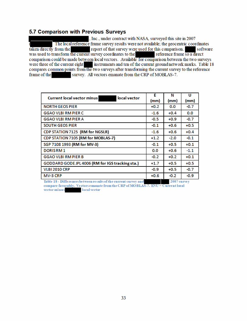
Table 3 – Cross-referenced Listing of Points including those from the 2007 survey by , Inc. (
11
Main-Scheme Marks CAL PIER A is defined by the top center of a stainless steel cup set into the top of a 30-cm (dia.) concrete observing pier. A temporary self-centering device was fabricated to allow survey equipment to be attached securely to the top of the pier and plumbed directly over the center of the cup. To expedite tacheometer/target tribrach set up, a socket-head bolt, CAL PIER A VPR, was drilled and epoxied into the southeast side of the pier. It is 0.13004 meter lower than CAL PIER A.
CAL PIER B3 is defined horizontally by a self-centering device (stainless steel plate w/5/8-11 stud) embedded in the top of a 30-cm (dia.) concrete observing pier. To expedite tacheometer/target tribrach set up, a socket-head bolt, CAL PIER B3 VPR, was drilled and epoxied into the west side of the pier. It is 0.14295 meter lower than CAL PIER B3.
CAL PIER D2 is defined horizontally by a self-centering device (stainless steel plate w/5/8-11 stud) embedded in the top of a 30-cm (dia.) concrete observing pier. The vertical point of reference is the head of a socket-head bolt protruding from the south side of the pier and about 20 cm below the top.
GGAO 1 is defined horizontally by a self-centering device (stainless steel plate w/5/8-11 stud) embedded in the top of a 30-cm (dia.) concrete observing pier. The vertical point of reference is the top surface of the plate at the base of the stud. The pier and its buried base, a 60 cm (dia.) x 3 m, is a steel reinforced monolith installed about two months prior to the start of the current survey.
GGAO 2 is defined horizontally by a self-centering device (stainless steel plate w/5/8-11 stud) embedded in the top of a 30-cm (dia.) concrete observing pier. The vertical point of reference is the top surface of the plate at the base of the stud. The pier and its buried base, a 60 cm (dia.) x 3 m, is a steel reinforced monolith installed about two months prior to the start of the current survey.
GGAO VLBI RM PIER A is defined horizontally by a self-centering device (stainless steel plate w/5/8-11 stud) embedded in the top of a 30-cm (dia.) concrete observing pier. The vertical point of reference is the top surface of the plate at the base of the stud.
GGAO VLBI RM PIER B is defined horizontally by a self-centering device (stainless steel plate w/5/8-11 stud) embedded in the top of a 30-cm (dia.) concrete observing pier. The vertical point of reference is the top surface of the plate at the base of the stud.
GGAO VLBI RM PIER C is defined horizontally by a self-centering device (stainless steel plate w/5/8-11 stud) embedded in the top of a 30-cm (dia.) concrete observing pier. The vertical point of reference is the top surface of the plate at the base of the stud.
GODDARD is defined horizontally and vertically by a small divot in the top-center of a brass disk stamped GODDARD 1962, set into the top of a 30-cm (dia.) concrete post recessed 5 cm below ground level.
GODDARD GODE JPL 4006 is defined horizontally and vertically by a small divot in the top-center of a stainless steel plate stamped GODDARD GORF EAST FLYNN GPS STATION MARK JPL 4006 1992, set into the top of a 60-cm (dia.) concrete post projecting about 30 cm above ground level.
NGS 1 is defined horizontally by a self-centering device (stainless steel plate w/5/8-11 stud) anchored in the top of a 15-cm (dia.) concrete observing pier encased in PVC pipe. The vertical point of reference is the head of a socket-head bolt protruding from the east side of the pier and about 20 cm below the top. The pier and its buried base, a 45 cm (dia.) x 1 m, is a monolith installed about two months prior to the start of the current survey.
12
NGS 2 is defined horizontally by a self-centering device (stainless steel plate w/5/8-11 stud) anchored in the top of a 15-cm (dia.) concrete observing pier encased in PVC pipe. The vertical point of reference is the head of a socket-head bolt protruding from the south side of the pier and about 20 cm below the top. The pier and its buried base, a 45 cm (dia.) x 1 m, is a monolith installed about two months prior to the start of the current survey.
NGS 3 is defined horizontally by a self-centering device (stainless steel plate w/5/8-11 stud) anchored in the top of a 15-cm (dia.) concrete observing pier encased in PVC pipe. The vertical point of reference is the head of a socket-head bolt protruding from the southeast side of the pier and about 20 cm below the top. The pier and its buried base, a 45 cm (dia.) x 1 m, is a monolith installed about two months prior to the start of the current survey.
NORTH GEOS PIER is defined horizontally and vertically by a cross etched into the top-center of a brass disk stamped NORTH GEOS PIER 1979, set into the top of a 90-cm (on side) triangular concrete monument projecting 40 cm above ground level.
SOUTH GEOS PIER is defined horizontally and vertically by a cross etched into the top-center of a brass disk stamped SOUTH GEOS PIER 1976, set into the top of a 90-cm (on side) triangular concrete monument projecting 40 cm above ground level.
Supplemental Marks
CAL PIER C is defined horizontally by the center of a stainless steel cup set into the top of a 30-cm (dia.) concrete observing pier. A 5/8-11 self-centering adapter for the cup held the survey target during measurements. To expedite tacheometer/target tribrach set up, a socket-head bolt, CAL PIER C VPR, was drilled and epoxied into the west side of the pier. It is 0.15116 meter lower than CAL PIER C.
CDP STATION 7105 is defined horizontally and vertically by a small divot in the top-center of a brass disk stamped MOBLAS STA 7105, set into a drill hole in the concrete pad currently occupied by MOBLAS 7’s trailer. It is the reference mark for MOBLAS 7.
CDP STATION 7125 is defined horizontally and vertically by a small divot in the top-center of a brass disk stamped GORF-MTLRS 7125 1985, set into a drill hole in the concrete pad occupied by the building housing NGSLR. It is the reference mark for NGSLR and is located east of the building.
CDP STATION 7130 is defined horizontally and vertically by a small divot in the top-center of a brass disk stamped 7130 1985, set into a drill hole in a concrete pad. The mark formed part of the ground network from a previous survey on file at the ITRF web site (see Table 2).
CDP STATION 7918 is defined horizontally and vertically by a small divot in the top-center of a brass disk stamped MOBLAS STA. 7918 1985, set into a drill hole in a concrete pad. The mark formed part of the ground network from a previous survey on file at the ITRF web site (see Table 2).
DORIS RM 1 is defined horizontally by a self-centering device (stainless steel plate w/5/8-11 stud) embedded in the top of a 30-cm (dia.) concrete support pier for the DORIS antenna. The vertical point of reference is the top surface of the plate at the base of the stud.
DORIS RM 2 is defined horizontally by a self-centering device (stainless steel plate w/5/8-11 stud) embedded in the top of a 30-cm (dia.) concrete support pier for the DORIS antenna. The vertical point of reference is the top surface of the stud. It is the reference mark for the DORIS antenna. GODN is defined horizontally by a self-centering device (SCIGN GNSS antenna mount) attached to the head block of a DDBM. The vertical point of reference is typical with the SCIGN mounts; a divot (8.3 mm) below the top plate. It is the reference mark for GODN GNSS antenna.
13
GODS is defined horizontally by a self-centering device (SCIGN GNSS antenna mount) attached to the head block of a DDBM. The vertical point of reference is typical with the SCIGN mounts; a divot (8.3 mm) below the top plate. It is the reference mark for GODS GNSS antenna.
REGINA 2707 RM is defined horizontally by a self-centering device (SCIGN GNSS antenna mount) attached to the head block of a DDBM. The vertical point of reference is typical with the SCIGN mounts; a divot (8.3 mm) below the top plate. It is the reference mark for REGINA GNSS antenna. The antenna had not yet been installed at the time of the survey allowing direct measurements to the SCIGN mount.
SGP 7108 1993 is defined horizontally and vertically by a small divot in the top-center of a brass disk stamped GGAO VLBI SGP 7108 1993, set into a drill hole in a concrete pad. The mark formed part of the ground network from a previous survey on file at the ITRF web site (see Table 2).
15
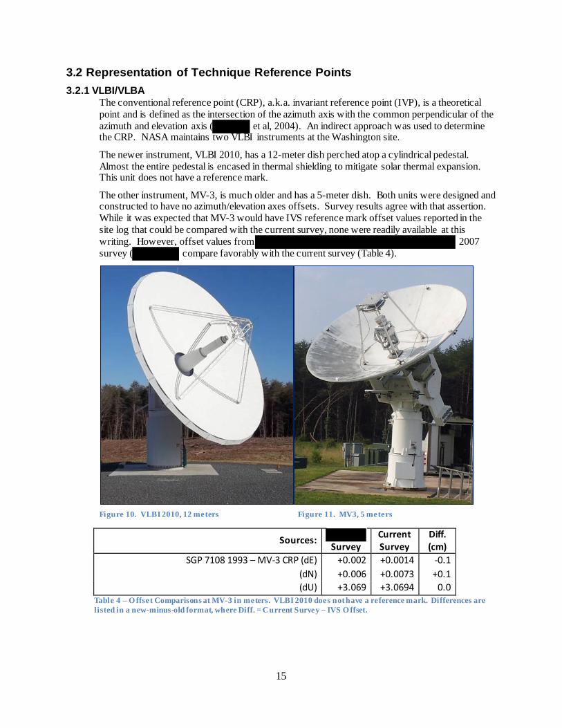
3.2 Representation of Technique Reference Points 3.2.1 VLBI/VLBA
The conventional reference point (CRP), a.k.a. invariant reference point (IVP), is a theoretical point and is defined as the intersection of the azimuth axis with the common perpendicular of the azimuth and elevation axis ( et al, 2004). An indirect approach was used to determine the CRP. NASA maintains two VLBI instruments at the Washington site.
The newer instrument, VLBI 2010, has a 12-meter dish perched atop a cylindrical pedestal. Almost the entire pedestal is encased in thermal shielding to mitigate solar thermal expansion. This unit does not have a reference mark.
The other instrument, MV-3, is much older and has a 5-meter dish. Both units were designed and constructed to have no azimuth/elevation axes offsets. Survey results agree with that assertion. While it was expected that MV-3 would have IVS reference mark offset values reported in the site log that could be compared with the current survey, none were readily available at this writing. However, offset values from 2007 survey ( compare favorably with the current survey (Table 4).
Figure 10. VLBI 2010, 12 meters Figure 11. MV3, 5 meters
Sources: Survey
Current Survey
Diff. (cm)
SGP 7108 1993 – MV-3 CRP (dE) +0.002 +0.0014 -0.1 (dN) +0.006 +0.0073 +0.1 (dU) +3.069 +3.0694 0.0
Table 4 – O ffset Comparisons at MV-3 in meters. VLBI 2010 does not have a reference mark. Differences are listed in a new-minus-old format, where Diff. = Current Survey – IVS O ffset.
16
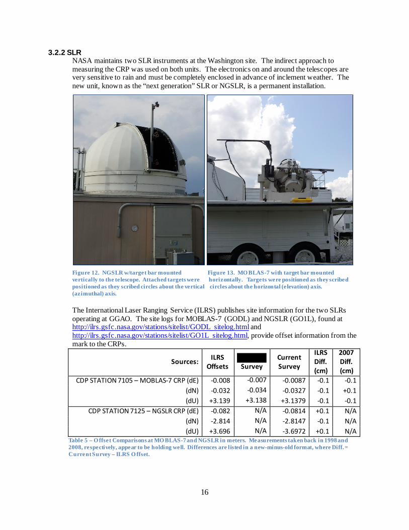
3.2.2 SLR NASA maintains two SLR instruments at the Washington site. The indirect approach to measuring the CRP was used on both units. The electronics on and around the telescopes are very sensitive to rain and must be completely enclosed in advance of inclement weather. The new unit, known as the “next generation” SLR or NGSLR, is a permanent installation.
Figure 12. NGSLR w/target bar mounted Figure 13. MO BLAS-7 with target bar mounted vertically to the te lescope. Attached targets were horizontally. Targets were positioned as they scribed positioned as they scribed circles about the vertical circles about the horizontal (e levation) axis. (azimuthal) axis.
The International Laser Ranging Service (ILRS) publishes site information for the two SLRs operating at GGAO. The site logs for MOBLAS-7 (GODL) and NGSLR (GO1L), found at http://ilrs.gsfc.nasa.gov/stations/sitelist/GODL sitelog.html and http://ilrs.gsfc.nasa.gov/stations/sitelist/GO1L sitelog.html, provide offset information from the mark to the CRPs.
Sources: ILRS Offsets Survey
Current Survey
ILRS Diff. (cm)
2007 Diff. (cm)
CDP STATION 7105 – MOBLAS-7 CRP (dE) -0.008 -0.007 -0.0087 -0.1 -0.1 (dN) -0.032 -0.034 -0.0327 -0.1 +0.1 (dU) +3.139 +3.138 +3.1379 -0.1 -0.1
CDP STATION 7125 – NGSLR CRP (dE) -0.082 N/A -0.0814 +0.1 N/A (dN) -2.814 N/A -2.8147 -0.1 N/A (dU) +3.696 N/A -3.6972 +0.1 N/A
Table 5 – O ffset Comparisons at MO BLAS-7 and NGSLR in meters. Measurements taken back in 1998 and 2008, respectively, appear to be holding well. Differences are listed in a new-minus-old format, where Diff. = Current Survey – ILRS O ffset.
17
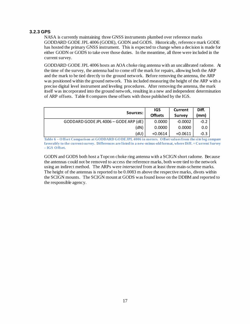
3.2.3 GPS NASA is currently maintaining three GNSS instruments plumbed over reference marks GODDARD GODE JPL 4006 (GODE), GODN and GODS. Historically, reference mark GODE has hosted the primary GNSS instrument. This is expected to change when a decision is made for either GODN or GODS to take over those duties. In the meantime, all three were included in the current survey.
GODDARD GODE JPL 4006 hosts an AOA choke ring antenna with an uncalibrated radome. At the time of the survey, the antenna had to come off the mark for repairs, allowing both the ARP and the mark to be tied directly to the ground network. Before removing the antenna, the ARP was positioned within the ground network. This included measuring the height of the ARP with a precise digital level instrument and leveling procedures. After removing the antenna, the mark itself was incorporated into the ground network, resulting in a new and independent determination of ARP offsets. Table 8 compares these offsets with those published by the IGS.
Sources: IGS
Offsets Current Survey
Diff. (mm)
GODDARD GODE JPL 4006 – GODE ARP (dE) 0.0000 -0.0002 -0.2 (dN) 0.0000 0.0000 0.0 (dU) +0.0614 +0.0611 -0.3
Table 6 – O ffset Comparison at GODDARD GO DE JPL 4006 in meters. O ffset values from the site log compare favorably to the current survey. Differences are listed in a new-minus-old format, where Diff. = Current Survey – IGS O ffset.
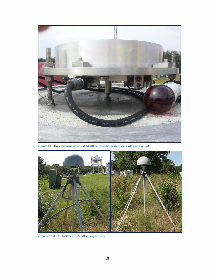
GODN and GODS both host a Topcon choke ring antenna with a SCIGN short radome. Because the antennas could not be removed to access the reference marks, both were tied to the network using an indirect method. The ARPs were intersected from at least three main-scheme marks. The height of the antennas is reported to be 0.0083 m above the respective marks, divots within the SCIGN mounts. The SCIGN mount at GODS was found loose on the DDBM and reported to the responsible agency.
18
Figure 14. The centering device at GODE with antenna in place, radome removed.
Figures 15 & 16. GO DS and GODN, respectively.
20
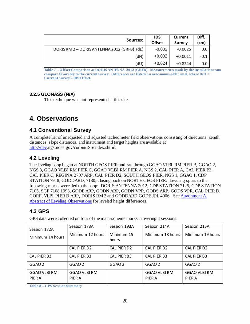
Sources: IDS
Offset Current Survey
Diff. (cm)
DORIS RM 2 – DORIS ANTENNA 2012 (GRFB) (dE) -0.002 -0.0025 0.0 (dN) +0.002 +0.0011 -0.1 (dU) +0.824 +0.8244 0.0
Table 7 – O ffset Comparison at DO RIS ANTENNA 2012 (GRFB). Measurements made by the installation team compare favorably to the current survey. Differences are listed in a new-minus-old format, where Diff. = Current Survey – IDS O ffset.
3.2.5 GLONASS (N/A) This technique was not represented at this site.
4. Observations 4.1 Conventional Survey A complete list of unadjusted and adjusted tacheometer field observations consisting of directions, zenith distances, slope distances, and instrument and target heights are available at http://dev.ngs.noaa.gov/corbin/ISS/index.shtml.
4.2 Leveling The leveling loop began at NORTH GEOS PIER and ran through GGAO VLBI RM PIER B, GGAO 2, NGS 3, GGAO VLBI RM PIER C, GGAO VLBI RM PIER A, NGS 2, CAL PIER A, CAL PIER B3, CAL PIER C, REGINA 2707 ARP, CAL PIER D2, SOUTH GEOS PIER, NGS 1, GGAO 1, CDP STATION 7918, GODDARD, 7130, closing back on NORTH GEOS PIER. Leveling spurs to the following marks were tied to the loop: DORIS ANTENNA 2012, CDP STATION 7125, CDP STATION 7105, SGP 7108 1993, GODE ARP, GODN ARP, GODN VPR, GODS ARP, GODS VPR, CAL PIER D, GORF, VLBI PIER B ARP, DORIS RM 2 and GODDARD GODE JPL 4006. See Attachment A. Abstract of Leveling Observations for leveled height differences.
4.3 GPS GPS data were collected on four of the main-scheme marks in overnight sessions.
Session 172A
Minimum 14 hours
Session 173A
Minimum 12 hours
Session 193A
Minimum 15 hours
Session 214A
Minimum 18 hours
Session 215A
Minimum 19 hours
CAL PIER D2 CAL PIER D2 CAL PIER D2 CAL PIER D2
CAL PIER B3 CAL PIER B3 CAL PIER B3 CAL PIER B3 CAL PIER B3
GGAO 2 GGAO 2 GGAO 2 GGAO 2 GGAO 2
GGAO VLBI RM PIER A
GGAO VLBI RM PIER A
GGAO VLBI RM PIER A
GGAO VLBI RM PIER A
Table 8 – GPS Session Summary
21
4.4 General Comments Data collection software GeoObs v1.04.02 was used for recording field measurements and for data quality checks.
Star*Net least-squares software was used to analyze thousands of extremely precise tacheometer measurements made to precision targets from the 15 main-scheme marks. The result is a very tight, very clean network of marks based in a local coordinate system.
As noted earlier, determining the local coordinates of the SLR and radio telescopes’ CRP requires an indirect approach. The principle is straight-forward. A point, as it revolves about an axis, scribes an arc. An arc defines a circle and a circle defines an axis. Assigning coordinates to the points along the arc defines the parameters of the axis. Tacheometer measurements from the ground network to a target attached to a telescope will generate coordinates on the points along the arc.
The minimum number of points needed to define a circle, and therefore an axis, is three. The minimum number of measurements needed to extend local coordinates to three points is ten (four horizontal directions, three vertical angles, and three slope distances). Twenty measurements will define two axes and provide local coordinates for the CRP.
In practice, a complex system of observations involving three targets secured to the telescope, measurements from two ground network marks, and at least 1,080 total measurements per axis ensure sub-millimeter results. At least 2,160 measurements are run through Star*Net and into AXIS software to determine one CRP. CRPs for the two VLBI instruments and two SLR instruments were determined in this manner
Another indirect approach, intersection, allows certain SGT instruments to continue uninterrupted operation while the tie to their reference mark is made. This approach was used on GODN, GODS, DORIS ANTENNA 2012, DORIS RM1 and RM 2. The horizontal ties to these four marks and the DORIS antenna were made by intersection from at least three ground network marks. At GODN, GODS and DORIS ANTENNA 2012, left and right tangents to the antennas were measured as close to the ARP as possible. Tangent observations were later reduced to the center of the antenna. The horizontal ties to DORIS RMs 1 and 2 were accomplished by intersection, also. But the mark could be observed directly and did not require tangent observations. All heights for these intersection stations were determined by differential leveling.
Differential leveling was also conducted through all ground network marks. Leveled height differences were used in conjunction with GPS-derived ellipsoid heights to learn more about the local geoid, and also check the quality of trigonometric leveling observations between network stations. The ability to compare trig leveling against a standard while observing the SLR and radio telescope targets in the same data set provided quality assurance for those observations.
22
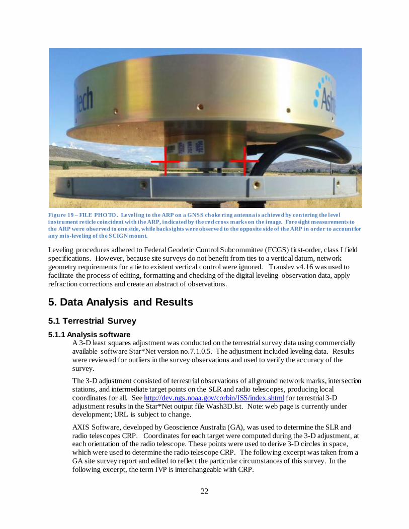
Figure 19 – FILE PHO TO . Leveling to the ARP on a GNSS choke ring antenna is achieved by centering the level instrument reticle coincident with the ARP, indicated by the red cross marks on the image. Foresight measurements to the ARP were observed to one side, while backsights were observed to the opposite side of the ARP in order to account for any mis-leveling of the SCIGN mount.
Leveling procedures adhered to Federal Geodetic Control Subcommittee (FCGS) first-order, class I field specifications. However, because site surveys do not benefit from ties to a vertical datum, network geometry requirements for a tie to existent vertical control were ignored. Translev v4.16 was used to facilitate the process of editing, formatting and checking of the digital leveling observation data, apply refraction corrections and create an abstract of observations.
5. Data Analysis and Results 5.1 Terrestrial Survey 5.1.1 Analysis software
A 3-D least squares adjustment was conducted on the terrestrial survey data using commercially available software Star*Net version no.7.1.0.5. The adjustment included leveling data. Results were reviewed for outliers in the survey observations and used to verify the accuracy of the survey.
The 3-D adjustment consisted of terrestrial observations of all ground network marks, intersection stations, and intermediate target points on the SLR and radio telescopes, producing local coordinates for all. See http://dev.ngs.noaa.gov/corbin/ISS/index.shtml for terrestrial 3-D adjustment results in the Star*Net output file Wash3D.lst. Note: web page is currently under development; URL is subject to change.
AXIS Software, developed by Geoscience Australia (GA), was used to determine the SLR and radio telescopes CRP. Coordinates for each target were computed during the 3-D adjustment, at each orientation of the radio telescope. These points were used to derive 3-D circles in space, which were used to determine the radio telescope CRP. The following excerpt was taken from a GA site survey report and edited to reflect the particular circumstances of this survey. In the following excerpt, the term IVP is interchangeable with CRP.
23
The StarNet .dmp file, generated by the 3-D adjustment, included the full variance-covariance matrix required by AXIS. The .dmp file was placed into a directory with the AXIS software along with a setup.axs file. The setup file was edited repeatedly to derive estimates of circle parameters for each target and each rotation sequence. Once initial estimates were refined for all target rotation sequences, geometric constraints were added. Initial constraints introduced included:
CDIST – used to constrain target coordinates so that target-to-target distances remain constant over all rotational sequences. ;
ENORMAL, NNORMAL, UNORMAL – used to constrain normal parameters together; CENTRE – used to constrain together centre to centre distances (azimuth axis only) RADIUS – used to constrain circle arc radius parameters together
With updated circle parameter estimates for each target rotation sequence, IVP coordinates were derived. Additional constraints were introduced to constrain separate IVP realizations. Constraints applied included:
OFFSET – used to constrain the computed offset to be identical for independent IVP estimates;
ORTHOG – used to constrain the orthogonality between three axes; UIVP – used to constrain the individual IVP determination in the UP component together.
CRP computation results can be found at http://dev.ngs.noaa.gov/corbin/ISS/index.shtml in the AXIS file output.axs, Section 4.18 COMPUTED SOLUTION PARAMETER SUMMARY.
5.1.2 Topocentric coordinates and covariance For topocentric coordinates and covariance information used in CRP computations, go to http://dev.ngs.noaa.gov/corbin/ISS/index.shtml, AXIS file output.axs, Section 2. INPUT SOLUTION.
5.1.3 Correlation matrix For computed correlation matrix information, see Attachment F. SINEX File NGSWASH1207GA.SNX.
5.1.4 Reference temperature of radio telescopes [for thermal expansion] A height correction for the CRP of MV-3 and VLBI2010 was computed based on the following procedure:
i) Compute a [30-day] temperature average and see to what extent it differs from the reference.
ii) Multiply the CRP height by 0.000012 and by the temperature difference iii) Correct the CRP height if it is needed.
• Telescope reference temperatures: +13.4OC for MV-3 from Antenna Information File Format Version of 2008.04.22 (A. Nothnagel, 2009) provided to NGS by the working group chair. See http://vlbi.geod.uni-bonn.de/IVS-AC/Conventions/antenna-info.txt. Because no reference temperature is provided for VLBI2010 at this time, the same value is used in computations for both telescopes
• 30-day temperature average. Continuous 30-day range consists of average daily temperatures. It concludes on second (final) day of survey measurements to each respective telescope.
o VLBI2010 (2012/05/24 – 2012/06/22): +21.5O C o MV-3 (2012/07/05 – 2012/08/03): +25.2O C
• Temperature difference (reference – observed) o VLBI2010: -8.1O C o MV-3: -11.8O C
24
• Total height of elevation axis (foundation + length of fixed axis) o VLBI2010: 6.8 meters o MV-3: 4.4 meters
VLBI2010 corr’n. = 6.8 m × 0.000012 m/m OC × -8.1O C = -0.0007 m
MV-3 corr’n. = 4.4 m × 0.000012 m/m OC × -11.80O C = -0.0006 m Note: The 30-day temperature average is the best available approximation of the temperature of the structure at the time of observations. The correction is provided for informational purposes and was not applied to either telescope.
5.2 GPS Observations 5.2.1 Analysis Software
NGS’s beta version of Online Positioning User’s Service (OPUS) Projects was used to post-process and perform a least-squares 3-D adjustment of GPS data.
OPUS Projects uses NGS’s PAGE5 v1203.27 for post-processing. Default settings were used with two exceptions; 1) GODN was set as a hub and 2) the cutoff elevation for processing was lowered to 10o. The remaining default settings resulted in the:
• use of IGS08.atx absolute antenna calibration file • use of IGS orbits (+/- 2 cm) • use of IGS08solution coordinate reference system with coordinates updated to date of
observations using velocities • use of default (modeled) meteorological values • use of dual-frequency ionospheric correction • time parameters solved in data reduction • double-difference, ionosphere-free (IF) combination solution, where
IF = {f21/(f21 – f22)}L1 – {f1f2/(f21 – f22)}L2
• not all integer biases were determinable resulting in partial, fixed integer estimate of biases
Intended accuracy of vectors is 0.1 ppm plus 0.5 cm (A-order). All base lines were measured at least twice, once on each of two days. Redundant vectors were checked against each other to ensure accuracy was met. See Attachment B. Redundant GPS Vectors.
OPUS Projects uses the program GPSCOM v1203.15, a simple Helmert Blocking normal equation processor which combines multiple GPS data sets that have initially been processed by the program PAGES, to form and partially reduce normal equations eliminating numerous nuisance parameters which are not generally of interest in a large global adjustment. The normal equation elements for the global parameters, those to be passed on to a combined adjustment, are written by PAGES into a normal equation file which becomes the basic input data for the program GPSCOM. One or more of these files as well as its own output normal equation files can then be processed by GPSCOM to provide a combined adjustment of the global parameters. This program was written in FORTRAN. Predominantly ANSI standard FORTRAN, a few isolated routines query the operating system for time and date, user and system identification. These “system” routines are inherently non-portable but, should be easily modified or disabled. For more information, go to http://www.ngs.noaa.gov/GRD/GPS/DOC/gpscom/gpscom.html
25
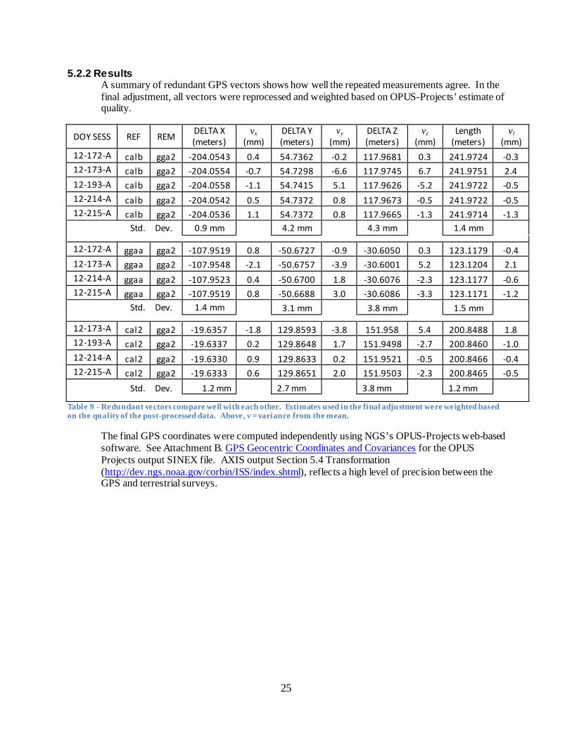
5.2.2 Results A summary of redundant GPS vectors shows how well the repeated measurements agree. In the final adjustment, all vectors were reprocessed and weighted based on OPUS-Projects’ estimate of quality.
DOY SESS REF REM DELTA X (meters)
vx (mm)
DELTA Y (meters)
vy (mm)
DELTA Z (meters)
vz (mm)
Length (meters)
vl (mm)
12-172-A calb gga2 -204.0543 0.4 54.7362 -0.2 117.9681 0.3 241.9724 -0.3 12-173-A calb gga2 -204.0554 -0.7 54.7298 -6.6 117.9745 6.7 241.9751 2.4 12-193-A calb gga2 -204.0558 -1.1 54.7415 5.1 117.9626 -5.2 241.9722 -0.5 12-214-A calb gga2 -204.0542 0.5 54.7372 0.8 117.9673 -0.5 241.9722 -0.5 12-215-A calb gga2 -204.0536 1.1 54.7372 0.8 117.9665 -1.3 241.9714 -1.3
Std. Dev. 0.9 mm 4.2 mm 4.3 mm 1.4 mm
12-172-A ggaa gga2 -107.9519 0.8 -50.6727 -0.9 -30.6050 0.3 123.1179 -0.4 12-173-A ggaa gga2 -107.9548 -2.1 -50.6757 -3.9 -30.6001 5.2 123.1204 2.1 12-214-A ggaa gga2 -107.9523 0.4 -50.6700 1.8 -30.6076 -2.3 123.1177 -0.6 12-215-A ggaa gga2 -107.9519 0.8 -50.6688 3.0 -30.6086 -3.3 123.1171 -1.2
Std. Dev. 1.4 mm 3.1 mm 3.8 mm 1.5 mm
12-173-A cal2 gga2 -19.6357 -1.8 129.8593 -3.8 151.958 5.4 200.8488 1.8 12-193-A cal2 gga2 -19.6337 0.2 129.8648 1.7 151.9498 -2.7 200.8460 -1.0 12-214-A cal2 gga2 -19.6330 0.9 129.8633 0.2 151.9521 -0.5 200.8466 -0.4 12-215-A cal2 gga2 -19.6333 0.6 129.8651 2.0 151.9503 -2.3 200.8465 -0.5 Std. Dev. 1.2 mm 2.7 mm 3.8 mm 1.2 mm
Table 9 - Redundant vectors compare well with each other. Estimates used in the final adjustment were weighted based on the quality of the post-processed data. Above, v = variance from the mean.
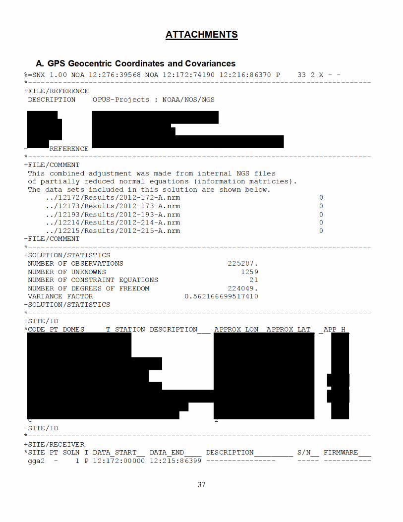
The final GPS coordinates were computed independently using NGS’s OPUS-Projects web-based software. See Attachment B. GPS Geocentric Coordinates and Covariances for the OPUS Projects output SINEX file. AXIS output Section 5.4 Transformation (http://dev.ngs.noaa.gov/corbin/ISS/index.shtml), reflects a high level of precision between the GPS and terrestrial surveys.
26
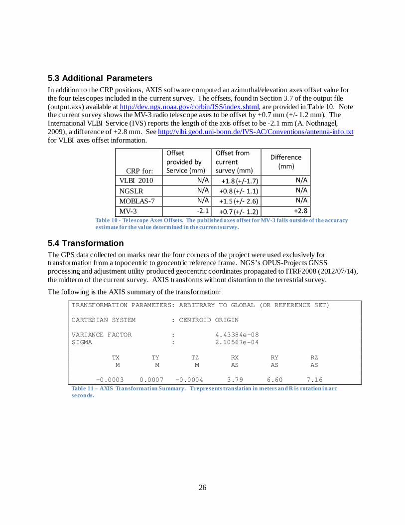
5.3 Additional Parameters In addition to the CRP positions, AXIS software computed an azimuthal/elevation axes offset value for the four telescopes included in the current survey. The offsets, found in Section 3.7 of the output file (output.axs) available at http://dev.ngs.noaa.gov/corbin/ISS/index.shtml, are provided in Table 10. Note the current survey shows the MV-3 radio telescope axes to be offset by +0.7 mm (+/- 1.2 mm). The International VLBI Service (IVS) reports the length of the axis offset to be -2.1 mm (A. Nothnagel, 2009), a difference of +2.8 mm. See http://vlbi.geod.uni-bonn.de/IVS-AC/Conventions/antenna-info.txt for VLBI axes offset information.
CRP for:
Offset provided by Service (mm)
Offset from current survey (mm)
Difference (mm)
VLBI 2010 N/A +1.8 (+/-1.7) N/A NGSLR N/A +0.8 (+/- 1.1) N/A MOBLAS-7 N/A +1.5 (+/- 2.6) N/A MV-3 -2.1 +0.7 (+/- 1.2) +2.8
Table 10 - Telescope Axes Offsets. The published axes offset for MV-3 falls outside of the accuracy estimate for the value determined in the current survey.
5.4 Transformation The GPS data collected on marks near the four corners of the project were used exclusively for transformation from a topocentric to geocentric reference frame. NGS’s OPUS-Projects GNSS processing and adjustment utility produced geocentric coordinates propagated to ITRF2008 (2012/07/14), the midterm of the current survey. AXIS transforms without distortion to the terrestrial survey.
The following is the AXIS summary of the transformation:
TRANSFORMATION PARAMETERS: ARBITRARY TO GLOBAL (OR REFERENCE SET) CARTESIAN SYSTEM : CENTROID ORIGIN VARIANCE FACTOR : 4.43384e-08 SIGMA : 2.10567e-04 TX TY TZ RX RY RZ M M M AS AS AS -0.0003 0.0007 -0.0004 3.79 6.60 7.16 Table 11 – AXIS Transformation Summary. T represents translation in meters and R is rotation in arc seconds.
27
5.5 Description of SINEX generation The SINEX file was directly generated by AXIS. For details, see AXIS output file, output.axs, Section 6.1 USER INPUT SINEX INFORMATION at http://dev.ngs.noaa.gov/corbin/ISS/index.shtml. The following SINEX naming convention, adopted by GSA for local survey data, was also used for this survey. XXXNNNNYYMMFV.SNX
Where:
XXX is a three-character organization designation NNNN is a four-character site designation YY is the year of the survey MM is the month of the survey F is the frame code (G for global, L for local) V is the file version
See Attachment C. for SINEX file NGSWASH1207GA.SNX.
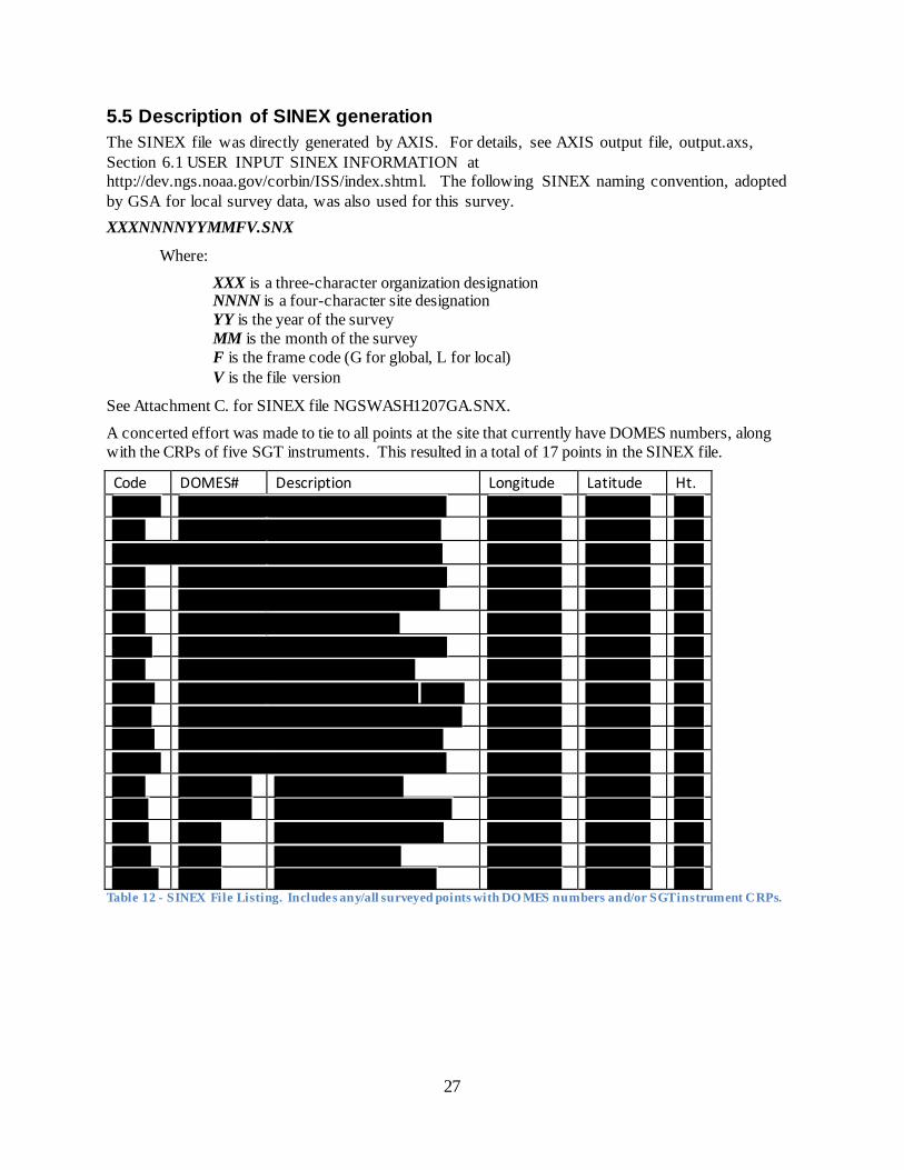
A concerted effort was made to tie to all points at the site that currently have DOMES numbers, along with the CRPs of five SGT instruments. This resulted in a total of 17 points in the SINEX file.
Code DOMES# Description Longitude Latitude Ht.
Table 12 - SINEX File Listing. Includes any/all surveyed points with DO MES numbers and/or SGT instrument CRPs.
28
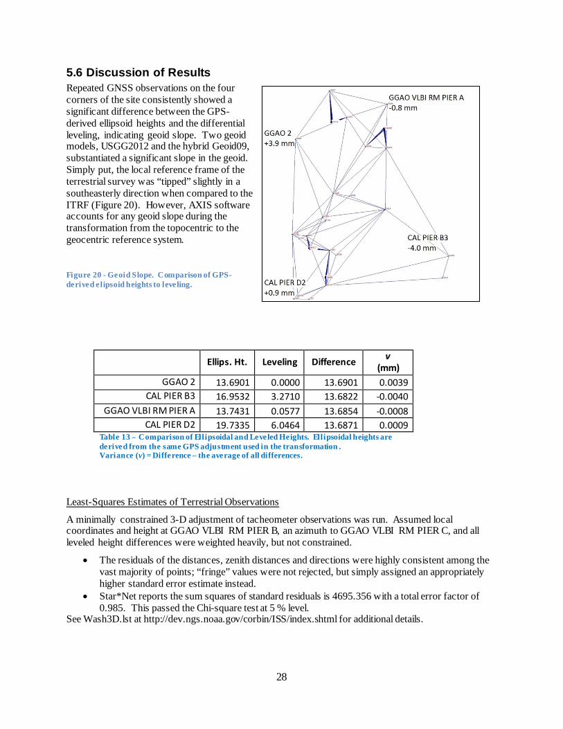
5.6 Discussion of Results Repeated GNSS observations on the four corners of the site consistently showed a significant difference between the GPS-derived ellipsoid heights and the differential leveling, indicating geoid slope. Two geoid models, USGG2012 and the hybrid Geoid09, substantiated a significant slope in the geoid. Simply put, the local reference frame of the terrestrial survey was “tipped” slightly in a southeasterly direction when compared to the ITRF (Figure 20). However, AXIS software accounts for any geoid slope during the transformation from the topocentric to the geocentric reference system.
Figure 20 - Geoid Slope. Comparison of GPS-derived elipsoid heights to leveling.
Ellips. Ht. Leveling Difference v (mm)
GGAO 2 13.6901 0.0000 13.6901 0.0039 CAL PIER B3 16.9532 3.2710 13.6822 -0.0040
GGAO VLBI RM PIER A 13.7431 0.0577 13.6854 -0.0008 CAL PIER D2 19.7335 6.0464 13.6871 0.0009
Table 13 – Comparison of Ellipsoidal and Leveled Heights. Ellipsoidal heights are derived from the same GPS adjustment used in the transformation . Variance (v) = Difference – the average of all differences.
Least-Squares Estimates of Terrestrial Observations
A minimally constrained 3-D adjustment of tacheometer observations was run. Assumed local coordinates and height at GGAO VLBI RM PIER B, an azimuth to GGAO VLBI RM PIER C, and all leveled height differences were weighted heavily, but not constrained.
• The residuals of the distances, zenith distances and directions were highly consistent among the vast majority of points; “fringe” values were not rejected, but simply assigned an appropriately higher standard error estimate instead.
• Star*Net reports the sum squares of standard residuals is 4695.356 with a total error factor of 0.985. This passed the Chi-square test at 5 % level.
See Wash3D.lst at http://dev.ngs.noaa.gov/corbin/ISS/index.shtml for additional details.
29
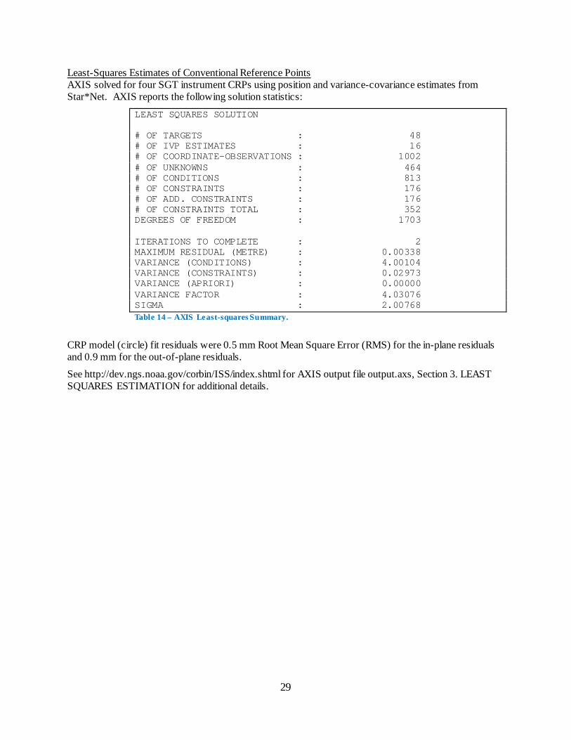
Least-Squares Estimates of Conventional Reference Points AXIS solved for four SGT instrument CRPs using position and variance-covariance estimates from Star*Net. AXIS reports the following solution statistics:
LEAST SQUARES SOLUTION # OF TARGETS : 48 # OF IVP ESTIMATES : 16 # OF COORDINATE-OBSERVATIONS : 1002 # OF UNKNOWNS : 464 # OF CONDITIONS : 813 # OF CONSTRAINTS : 176 # OF ADD. CONSTRAINTS : 176 # OF CONSTRAINTS TOTAL : 352 DEGREES OF FREEDOM : 1703 ITERATIONS TO COMPLETE : 2 MAXIMUM RESIDUAL (METRE) : 0.00338 VARIANCE (CONDITIONS) : 4.00104 VARIANCE (CONSTRAINTS) : 0.02973 VARIANCE (APRIORI) : 0.00000 VARIANCE FACTOR : 4.03076 SIGMA : 2.00768 Table 14 – AXIS Least-squares Summary.
CRP model (circle) fit residuals were 0.5 mm Root Mean Square Error (RMS) for the in-plane residuals and 0.9 mm for the out-of-plane residuals.
See http://dev.ngs.noaa.gov/corbin/ISS/index.shtml for AXIS output file output.axs, Section 3. LEAST SQUARES ESTIMATION for additional details.
30
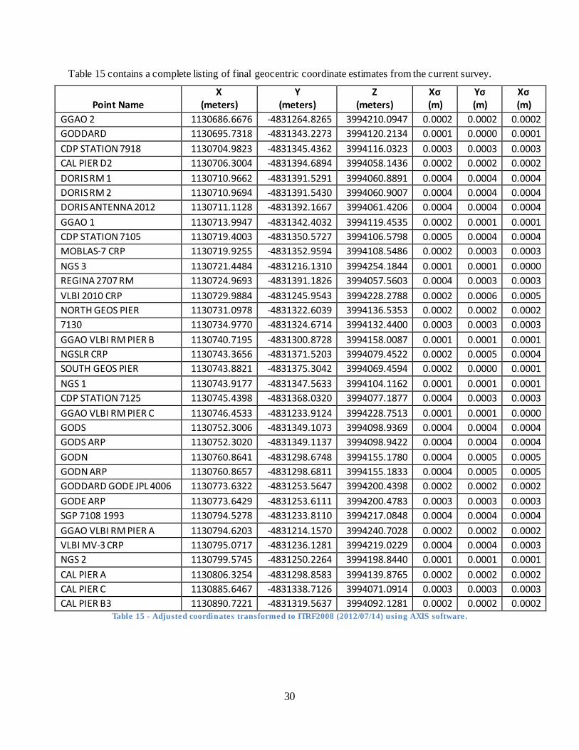
Table 15 contains a complete listing of final geocentric coordinate estimates from the current survey.
Point Name X
(meters) Y
(meters) Z
(meters) Xσ (m)
Yσ (m)
Xσ (m)
GGAO 2 1130686.6676 -4831264.8265 3994210.0947 0.0002 0.0002 0.0002 GODDARD 1130695.7318 -4831343.2273 3994120.2134 0.0001 0.0000 0.0001 CDP STATION 7918 1130704.9823 -4831345.4362 3994116.0323 0.0003 0.0003 0.0003 CAL PIER D2 1130706.3004 -4831394.6894 3994058.1436 0.0002 0.0002 0.0002 DORIS RM 1 1130710.9662 -4831391.5291 3994060.8891 0.0004 0.0004 0.0004 DORIS RM 2 1130710.9694 -4831391.5430 3994060.9007 0.0004 0.0004 0.0004 DORIS ANTENNA 2012 1130711.1128 -4831392.1667 3994061.4206 0.0004 0.0004 0.0004 GGAO 1 1130713.9947 -4831342.4032 3994119.4535 0.0002 0.0001 0.0001 CDP STATION 7105 1130719.4003 -4831350.5727 3994106.5798 0.0005 0.0004 0.0004 MOBLAS-7 CRP 1130719.9255 -4831352.9594 3994108.5486 0.0002 0.0003 0.0003 NGS 3 1130721.4484 -4831216.1310 3994254.1844 0.0001 0.0001 0.0000 REGINA 2707 RM 1130724.9693 -4831391.1826 3994057.5603 0.0004 0.0003 0.0003 VLBI 2010 CRP 1130729.9884 -4831245.9543 3994228.2788 0.0002 0.0006 0.0005 NORTH GEOS PIER 1130731.0978 -4831322.6039 3994136.5353 0.0002 0.0002 0.0002 7130 1130734.9770 -4831324.6714 3994132.4400 0.0003 0.0003 0.0003 GGAO VLBI RM PIER B 1130740.7195 -4831300.8728 3994158.0087 0.0001 0.0001 0.0001 NGSLR CRP 1130743.3656 -4831371.5203 3994079.4522 0.0002 0.0005 0.0004 SOUTH GEOS PIER 1130743.8821 -4831375.3042 3994069.4594 0.0002 0.0000 0.0001 NGS 1 1130743.9177 -4831347.5633 3994104.1162 0.0001 0.0001 0.0001 CDP STATION 7125 1130745.4398 -4831368.0320 3994077.1877 0.0004 0.0003 0.0003 GGAO VLBI RM PIER C 1130746.4533 -4831233.9124 3994228.7513 0.0001 0.0001 0.0000 GODS 1130752.3006 -4831349.1073 3994098.9369 0.0004 0.0004 0.0004 GODS ARP 1130752.3020 -4831349.1137 3994098.9422 0.0004 0.0004 0.0004 GODN 1130760.8641 -4831298.6748 3994155.1780 0.0004 0.0005 0.0005 GODN ARP 1130760.8657 -4831298.6811 3994155.1833 0.0004 0.0005 0.0005 GODDARD GODE JPL 4006 1130773.6322 -4831253.5647 3994200.4398 0.0002 0.0002 0.0002 GODE ARP 1130773.6429 -4831253.6111 3994200.4783 0.0003 0.0003 0.0003 SGP 7108 1993 1130794.5278 -4831233.8110 3994217.0848 0.0004 0.0004 0.0004 GGAO VLBI RM PIER A 1130794.6203 -4831214.1570 3994240.7028 0.0002 0.0002 0.0002 VLBI MV-3 CRP 1130795.0717 -4831236.1281 3994219.0229 0.0004 0.0004 0.0003 NGS 2 1130799.5745 -4831250.2264 3994198.8440 0.0001 0.0001 0.0001 CAL PIER A 1130806.3254 -4831298.8583 3994139.8765 0.0002 0.0002 0.0002 CAL PIER C 1130885.6467 -4831338.7126 3994071.0914 0.0003 0.0003 0.0003 CAL PIER B3 1130890.7221 -4831319.5637 3994092.1281 0.0002 0.0002 0.0002
Table 15 - Adjusted coordinates transformed to ITRF2008 (2012/07/14) using AXIS software.
31
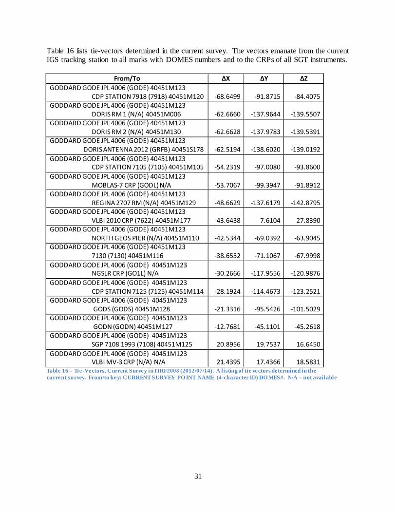
Table 16 lists tie-vectors determined in the current survey. The vectors emanate from the current IGS tracking station to all marks with DOMES numbers and to the CRPs of all SGT instruments.
From/To ΔX ΔY ΔZ GODDARD GODE JPL 4006 (GODE) 40451M123 CDP STATION 7918 (7918) 40451M120 -68.6499 -91.8715 -84.4075 GODDARD GODE JPL 4006 (GODE) 40451M123 DORIS RM 1 (N/A) 40451M006 -62.6660 -137.9644 -139.5507 GODDARD GODE JPL 4006 (GODE) 40451M123 DORIS RM 2 (N/A) 40451M130 -62.6628 -137.9783 -139.5391 GODDARD GODE JPL 4006 (GODE) 40451M123 DORIS ANTENNA 2012 (GRFB) 40451S178 -62.5194 -138.6020 -139.0192 GODDARD GODE JPL 4006 (GODE) 40451M123 CDP STATION 7105 (7105) 40451M105 -54.2319 -97.0080 -93.8600 GODDARD GODE JPL 4006 (GODE) 40451M123 MOBLAS-7 CRP (GODL) N/A -53.7067 -99.3947 -91.8912 GODDARD GODE JPL 4006 (GODE) 40451M123 REGINA 2707 RM (N/A) 40451M129 -48.6629 -137.6179 -142.8795 GODDARD GODE JPL 4006 (GODE) 40451M123 VLBI 2010 CRP (7622) 40451M177 -43.6438 7.6104 27.8390 GODDARD GODE JPL 4006 (GODE) 40451M123 NORTH GEOS PIER (N/A) 40451M110 -42.5344 -69.0392 -63.9045 GODDARD GODE JPL 4006 (GODE) 40451M123 7130 (7130) 40451M116 -38.6552 -71.1067 -67.9998 GODDARD GODE JPL 4006 (GODE) 40451M123 NGSLR CRP (GO1L) N/A -30.2666 -117.9556 -120.9876 GODDARD GODE JPL 4006 (GODE) 40451M123 CDP STATION 7125 (7125) 40451M114 -28.1924 -114.4673 -123.2521 GODDARD GODE JPL 4006 (GODE) 40451M123 GODS (GODS) 40451M128 -21.3316 -95.5426 -101.5029 GODDARD GODE JPL 4006 (GODE) 40451M123 GODN (GODN) 40451M127 -12.7681 -45.1101 -45.2618 GODDARD GODE JPL 4006 (GODE) 40451M123 SGP 7108 1993 (7108) 40451M125 20.8956 19.7537 16.6450 GODDARD GODE JPL 4006 (GODE) 40451M123 VLBI MV-3 CRP (N/A) N/A 21.4395 17.4366 18.5831
Table 16 – Tie-Vectors, Current Survey in ITRF2008 (2012/07/14). A listing of tie vectors determined in the current survey. From/to key: CURRENT SURVEY PO INT NAME (4-character ID) DO MES#. N/A – not available
32
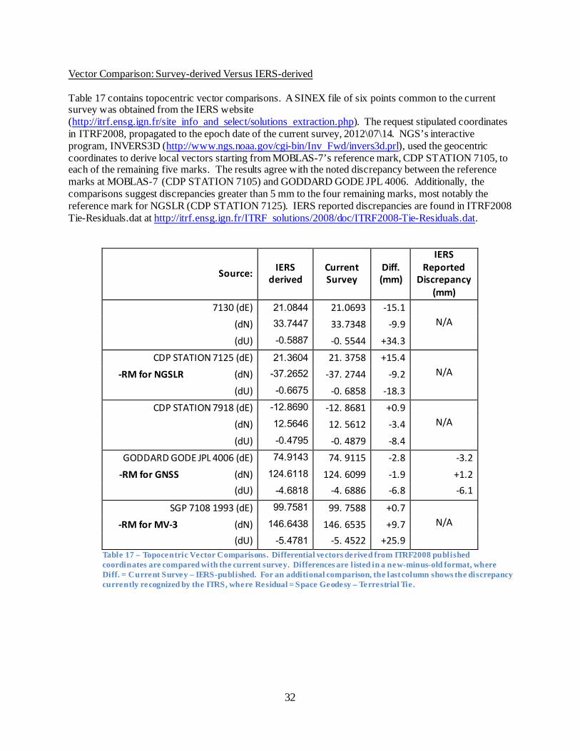
Vector Comparison: Survey-derived Versus IERS-derived Table 17 contains topocentric vector comparisons. A SINEX file of six points common to the current survey was obtained from the IERS website (http://itrf.ensg.ign.fr/site info and select/solutions extraction.php). The request stipulated coordinates in ITRF2008, propagated to the epoch date of the current survey, 2012\07\14. NGS’s interactive program, INVERS3D (http://www.ngs.noaa.gov/cgi-bin/Inv Fwd/invers3d.prl), used the geocentric coordinates to derive local vectors starting from MOBLAS-7’s reference mark, CDP STATION 7105, to each of the remaining five marks. The results agree with the noted discrepancy between the reference marks at MOBLAS-7 (CDP STATION 7105) and GODDARD GODE JPL 4006. Additionally, the comparisons suggest discrepancies greater than 5 mm to the four remaining marks, most notably the reference mark for NGSLR (CDP STATION 7125). IERS reported discrepancies are found in ITRF2008 Tie-Residuals.dat at http://itrf.ensg.ign.fr/ITRF solutions/2008/doc/ITRF2008-Tie-Residuals.dat.
Source: IERS derived
Current Survey
Diff. (mm)
IERS Reported
Discrepancy (mm)
7130 (dE) 21.0844 21.0693 -15.1
(dN) 33.7447 33.7348 -9.9 N/A
(dU) -0.5887 -0. 5544 +34.3
CDP STATION 7125 (dE) 21.3604 21. 3758 +15.4
-RM for NGSLR (dN) -37.2652 -37. 2744 -9.2 N/A
(dU) -0.6675 -0. 6858 -18.3
CDP STATION 7918 (dE) -12.8690 -12. 8681 +0.9
(dN) 12.5646 12. 5612 -3.4 N/A
(dU) -0.4795 -0. 4879 -8.4
GODDARD GODE JPL 4006 (dE) 74.9143 74. 9115 -2.8 -3.2 -RM for GNSS (dN) 124.6118 124. 6099 -1.9 +1.2
(dU) -4.6818 -4. 6886 -6.8 -6.1
SGP 7108 1993 (dE) 99.7581 99. 7588 +0.7
-RM for MV-3 (dN) 146.6438 146. 6535 +9.7 N/A
(dU) -5.4781 -5. 4522 +25.9 Table 17 – Topocentric Vector Comparisons. Differential vectors derived from ITRF2008 published coordinates are compared with the current survey. Differences are listed in a new-minus-old format, where Diff. = Current Survey – IERS-published. For an additional comparison, the last column shows the discrepancy currently recognized by the ITRS, where Residual = Space Geodesy – Terrestrial Tie .
34
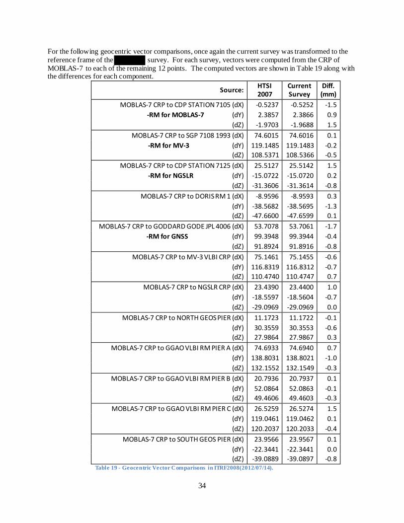
For the following geocentric vector comparisons, once again the current survey was transformed to the reference frame of the survey. For each survey, vectors were computed from the CRP of MOBLAS-7 to each of the remaining 12 points. The computed vectors are shown in Table 19 along with the differences for each component.
Table 19 - Geocentric Vector Comparisons in ITRF2008(2012/07/14).
Source: HTSI 2007
Current Survey
Diff. (mm)
MOBLAS-7 CRP to CDP STATION 7105 (dX) -0.5237 -0.5252 -1.5 -RM for MOBLAS-7 (dY) 2.3857 2.3866 0.9
(dZ) -1.9703 -1.9688 1.5 MOBLAS-7 CRP to SGP 7108 1993 (dX) 74.6015 74.6016 0.1
-RM for MV-3 (dY) 119.1485 119.1483 -0.2 (dZ) 108.5371 108.5366 -0.5
MOBLAS-7 CRP to CDP STATION 7125 (dX) 25.5127 25.5142 1.5 -RM for NGSLR (dY) -15.0722 -15.0720 0.2
(dZ) -31.3606 -31.3614 -0.8 MOBLAS-7 CRP to DORIS RM 1 (dX) -8.9596 -8.9593 0.3
(dY) -38.5682 -38.5695 -1.3 (dZ) -47.6600 -47.6599 0.1
MOBLAS-7 CRP to GODDARD GODE JPL 4006 (dX) 53.7078 53.7061 -1.7 -RM for GNSS (dY) 99.3948 99.3944 -0.4
(dZ) 91.8924 91.8916 -0.8 MOBLAS-7 CRP to MV-3 VLBI CRP (dX) 75.1461 75.1455 -0.6
(dY) 116.8319 116.8312 -0.7 (dZ) 110.4740 110.4747 0.7
MOBLAS-7 CRP to NGSLR CRP (dX) 23.4390 23.4400 1.0 (dY) -18.5597 -18.5604 -0.7 (dZ) -29.0969 -29.0969 0.0
MOBLAS-7 CRP to NORTH GEOS PIER (dX) 11.1723 11.1722 -0.1 (dY) 30.3559 30.3553 -0.6 (dZ) 27.9864 27.9867 0.3
MOBLAS-7 CRP to GGAO VLBI RM PIER A (dX) 74.6933 74.6940 0.7 (dY) 138.8031 138.8021 -1.0 (dZ) 132.1552 132.1549 -0.3
MOBLAS-7 CRP to GGAO VLBI RM PIER B (dX) 20.7936 20.7937 0.1 (dY) 52.0864 52.0863 -0.1 (dZ) 49.4606 49.4603 -0.3
MOBLAS-7 CRP to GGAO VLBI RM PIER C (dX) 26.5259 26.5274 1.5 (dY) 119.0461 119.0462 0.1 (dZ) 120.2037 120.2033 -0.4
MOBLAS-7 CRP to SOUTH GEOS PIER (dX) 23.9566 23.9567 0.1 (dY) -22.3441 -22.3441 0.0 (dZ) -39.0889 -39.0897 -0.8

39
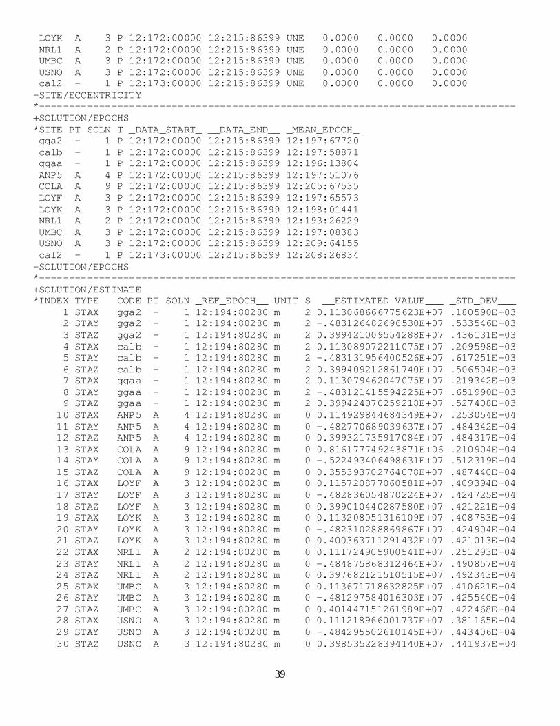
LOYK A 3 P 12:172:00000 12:215:86399 UNE 0.0000 0.0000 0.0000 NRL1 A 2 P 12:172:00000 12:215:86399 UNE 0.0000 0.0000 0.0000 UMBC A 3 P 12:172:00000 12:215:86399 UNE 0.0000 0.0000 0.0000 USNO A 3 P 12:172:00000 12:215:86399 UNE 0.0000 0.0000 0.0000 cal2 - 1 P 12:173:00000 12:215:86399 UNE 0.0000 0.0000 0.0000 -SITE/ECCENTRICITY *------------------------------------------------------------------------------- +SOLUTION/EPOCHS *SITE PT SOLN T _DATA_START_ __DATA_END__ _MEAN_EPOCH_ gga2 - 1 P 12:172:00000 12:215:86399 12:197:67720 calb - 1 P 12:172:00000 12:215:86399 12:197:58871 ggaa - 1 P 12:172:00000 12:215:86399 12:196:13804 ANP5 A 4 P 12:172:00000 12:215:86399 12:197:51076 COLA A 9 P 12:172:00000 12:215:86399 12:205:67535 LOYF A 3 P 12:172:00000 12:215:86399 12:197:65573 LOYK A 3 P 12:172:00000 12:215:86399 12:198:01441 NRL1 A 2 P 12:172:00000 12:215:86399 12:193:26229 UMBC A 3 P 12:172:00000 12:215:86399 12:197:08383 USNO A 3 P 12:172:00000 12:215:86399 12:209:64155 cal2 - 1 P 12:173:00000 12:215:86399 12:208:26834 -SOLUTION/EPOCHS *------------------------------------------------------------------------------- +SOLUTION/ESTIMATE *INDEX TYPE CODE PT SOLN _REF_EPOCH__ UNIT S __ESTIMATED VALUE___ _STD_DEV___ 1 STAX gga2 - 1 12:194:80280 m 2 0.113068666775623E+07 .180590E-03 2 STAY gga2 - 1 12:194:80280 m 2 -.483126482696530E+07 .533546E-03 3 STAZ gga2 - 1 12:194:80280 m 2 0.399421009554288E+07 .436131E-03 4 STAX calb - 1 12:194:80280 m 2 0.113089072211075E+07 .209598E-03 5 STAY calb - 1 12:194:80280 m 2 -.483131956400526E+07 .617251E-03 6 STAZ calb - 1 12:194:80280 m 2 0.399409212861740E+07 .506504E-03 7 STAX ggaa - 1 12:194:80280 m 2 0.113079462047075E+07 .219342E-03 8 STAY ggaa - 1 12:194:80280 m 2 -.483121415594225E+07 .651990E-03 9 STAZ ggaa - 1 12:194:80280 m 2 0.399424070259218E+07 .527408E-03 10 STAX ANP5 A 4 12:194:80280 m 0 0.114929844684349E+07 .253054E-04 11 STAY ANP5 A 4 12:194:80280 m 0 -.482770689039637E+07 .484342E-04 12 STAZ ANP5 A 4 12:194:80280 m 0 0.399321735917084E+07 .484317E-04 13 STAX COLA A 9 12:194:80280 m 0 0.816177749243871E+06 .210904E-04 14 STAY COLA A 9 12:194:80280 m 0 -.522493406498631E+07 .512319E-04 15 STAZ COLA A 9 12:194:80280 m 0 0.355393702764078E+07 .487440E-04 16 STAX LOYF A 3 12:194:80280 m 0 0.115720877060581E+07 .409394E-04 17 STAY LOYF A 3 12:194:80280 m 0 -.482836054870224E+07 .424725E-04 18 STAZ LOYF A 3 12:194:80280 m 0 0.399010440287580E+07 .421221E-04 19 STAX LOYK A 3 12:194:80280 m 0 0.113208051316109E+07 .408783E-04 20 STAY LOYK A 3 12:194:80280 m 0 -.482310288869867E+07 .424904E-04 21 STAZ LOYK A 3 12:194:80280 m 0 0.400363711291432E+07 .421013E-04 22 STAX NRL1 A 2 12:194:80280 m 0 0.111724905900541E+07 .251293E-04 23 STAY NRL1 A 2 12:194:80280 m 0 -.484875868312464E+07 .490857E-04 24 STAZ NRL1 A 2 12:194:80280 m 0 0.397682121510515E+07 .492343E-04 25 STAX UMBC A 3 12:194:80280 m 0 0.113671718632825E+07 .410621E-04 26 STAY UMBC A 3 12:194:80280 m 0 -.481297584016303E+07 .425540E-04 27 STAZ UMBC A 3 12:194:80280 m 0 0.401447151261989E+07 .422468E-04 28 STAX USNO A 3 12:194:80280 m 0 0.111218966001737E+07 .381165E-04 29 STAY USNO A 3 12:194:80280 m 0 -.484295502610145E+07 .443406E-04 30 STAZ USNO A 3 12:194:80280 m 0 0.398535228394140E+07 .441937E-04
40
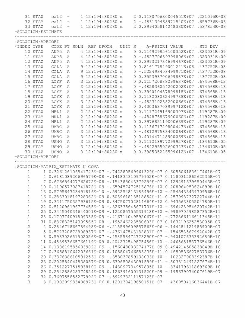
31 STAX cal2 - 1 12:194:80280 m 2 0.113070630004551E+07 .221095E-03 32 STAY cal2 - 1 12:194:80280 m 2 -.483139468971540E+07 .659736E-03 33 STAZ cal2 - 1 12:194:80280 m 2 0.399405814248330E+07 .537854E-03 -SOLUTION/ESTIMATE *------------------------------------------------------------------------------- +SOLUTION/APRIORI *INDEX TYPE CODE PT SOLN _REF_EPOCH__ UNIT S __A-PRIORI VALUE____ _STD_DEV___ 10 STAX ANP5 A 4 12:194:80280 m 0 0.114929856100352E+07 .323031E+09 11 STAY ANP5 A 4 12:194:80280 m 0 -.482770689399806E+07 .323031E+09 12 STAZ ANP5 A 4 12:194:80280 m 0 0.399321734699467E+07 .323031E+09 13 STAX COLA A 9 12:194:80280 m 0 0.816177849001241E+06 .437752E+08 14 STAY COLA A 9 12:194:80280 m 0 -.522493408499971E+07 .437752E+08 15 STAZ COLA A 9 12:194:80280 m 0 0.355393700699887E+07 .437752E+08 16 STAX LOYF A 3 12:194:80280 m 0 0.115720888299637E+07 .674568E+13 17 STAY LOYF A 3 12:194:80280 m 0 -.482836054200202E+07 .674568E+13 18 STAZ LOYF A 3 12:194:80280 m 0 0.399010437899818E+07 .674568E+13 19 STAX LOYK A 3 12:194:80280 m 0 0.113208062499738E+07 .674568E+13 20 STAY LOYK A 3 12:194:80280 m 0 -.482310288200066E+07 .674568E+13 21 STAZ LOYK A 3 12:194:80280 m 0 0.400363708999712E+07 .674568E+13 22 STAX NRL1 A 2 12:194:80280 m 0 0.111724916900307E+07 .119287E+09 23 STAY NRL1 A 2 12:194:80280 m 0 -.484875867900060E+07 .119287E+09 24 STAZ NRL1 A 2 12:194:80280 m 0 0.397682119000639E+07 .119287E+09 25 STAX UMBC A 3 12:194:80280 m 0 0.113671729800447E+07 .674568E+13 26 STAY UMBC A 3 12:194:80280 m 0 -.481297583400064E+07 .674568E+13 27 STAZ UMBC A 3 12:194:80280 m 0 0.401447148900069E+07 .674568E+13 28 STAX USNO A 3 12:194:80280 m 0 0.111218977299927E+07 .134610E+05 29 STAY USNO A 3 12:194:80280 m 0 -.484295502600323E+07 .134610E+05 30 STAZ USNO A 3 12:194:80280 m 0 0.398535226599612E+07 .134610E+05 -SOLUTION/APRIORI *------------------------------------------------------------------------------- +SOLUTION/MATRIX_ESTIMATE U COVA 1 1 0.326126106541743E-07 -.742280569961329E-07 0.605506183617461E-07 1 4 0.618108920696579E-08 -.141834310979952E-07 0.118031286562535E-07 1 7 0.676659427762672E-08 -.154385043379259E-07 0.129291339650443E-07 1 10 0.119057308741872E-09 -.659457472513876E-10 0.208964050624899E-10 1 13 0.579564723491816E-10 -.592254813186496E-10 -.254543343970956E-10 1 16 0.283301819728362E-09 0.508961818518854E-11 0.257998732722744E-10 1 19 0.321175035793615E-09 0.847507702814664E-12 0.943563805504780E-11 1 22 0.512096196773455E-10 -.326335645671731E-10 -.696428954620742E-11 1 25 0.344504034644001E-09 -.122085755531918E-10 -.998970598587352E-11 1 28 0.170774091809335E-09 -.416714049592067E-11 -.772366116611345E-11 1 31 0.837882514309565E-08 -.195246228580603E-07 0.163219625258005E-07 2 2 0.284671866789498E-06 -.215599609857563E-06 -.144284121985900E-07 2 5 0.572320872808937E-07 -.436147548182831E-07 -.154658567992042E-07 2 8 0.598302651502056E-07 -.458558472773290E-07 -.940107635392680E-10 2 11 0.453953665766119E-09 0.204232549875456E-10 -.446565153776546E-10 2 14 0.138619585603982E-09 -.156048003274177E-09 0.494214505838849E-10 2 17 0.365881064203661E-09 0.105804766883236E-11 0.465053662753736E-10 2 20 0.337638610591253E-09 -.358037859138033E-10 -.102827008392387E-10 2 23 0.202584044838087E-09 0.630650843091599E-11 -.803812491227674E-11 2 26 0.351227751593810E-09 -.148097734957895E-10 -.334179311869369E-10 2 29 0.254288628374824E-09 0.126391600131520E-09 -.195679074007619E-07 2 32 0.769755855277992E-07 -.592933211157123E-07 3 3 0.190209983408973E-06 0.120130419650151E-07 -.436950416036441E-07
41
3 6 0.388703200951053E-07 0.129355386608921E-07 -.458073949653717E-07 3 9 0.412262939346219E-07 0.270431598129605E-10 -.358587617979498E-10 3 12 0.401444768083981E-09 -.100474202173869E-11 -.411119758086707E-11 3 15 0.296918636400308E-09 -.268173928649521E-10 -.884503271587307E-11 3 18 0.347663101382862E-09 -.228530345325104E-10 0.244085770674472E-11 3 21 0.367714657253190E-09 -.186004412141959E-10 -.843015192377737E-11 3 24 0.193698513158057E-09 0.178512738182714E-10 -.259634079111815E-10 3 27 0.323890335876917E-09 0.390555890348441E-10 0.315344570680065E-10 3 30 0.180170589934011E-09 0.163457149138339E-07 -.592976173337845E-07 3 33 0.523096878061062E-07 4 4 0.439314440094967E-07 -.103221207555567E-06 0.842847713319807E-07 4 7 0.636500604896828E-08 -.147410917402099E-07 0.121129271944090E-07 4 10 0.126938449713084E-09 -.741346236256100E-10 0.121008383185656E-10 4 13 0.599609151578516E-10 -.645962408133997E-10 -.304957988791970E-10 4 16 0.303302701787929E-09 0.938430809468778E-12 0.200356359759034E-10 4 19 0.324862628611401E-09 -.314416884258999E-12 0.913864287574281E-11 4 22 0.542297784839399E-10 -.373903528898630E-10 -.764029500801063E-11 4 25 0.310808869105062E-09 -.859565866465398E-11 0.256903590425660E-12 4 28 0.150066717173227E-09 0.821270459181086E-11 0.746419744939179E-12 4 31 0.649339914305516E-08 -.151690897796207E-07 0.124292915900983E-07 5 5 0.380998747263623E-06 -.292289148037615E-06 -.145787861973610E-07 5 8 0.587405276174421E-07 -.443615936604074E-07 -.103216267217896E-09 5 11 0.486673568891564E-09 0.438675198089366E-10 -.484548545157095E-10 5 14 0.151899406622046E-09 -.146961660365897E-09 0.442420190042463E-10 5 17 0.392300983635869E-09 0.133300356881226E-10 0.802681853743737E-10 5 20 0.358676712639763E-09 -.357098400346832E-10 -.132737287004469E-10 5 23 0.217862043228859E-09 0.487845407282991E-11 0.163456854865687E-10 5 26 0.346749929727905E-09 -.923902554118100E-11 -.556041661778736E-10 5 29 0.161803843255224E-09 0.780492263316168E-10 -.149932009263161E-07 5 32 0.605041396736730E-07 -.458119736241543E-07 6 6 0.256546741269770E-06 0.119843695542396E-07 -.443606434478729E-07 6 9 0.390942126415774E-07 0.306250705921708E-10 -.441639300142482E-10 6 12 0.404679197981784E-09 0.147021642651311E-11 -.166241755291272E-10 6 15 0.288482784771572E-09 -.223538329346677E-10 -.158238425338332E-10 6 18 0.355255498763055E-09 -.528692132087787E-10 -.171254667630087E-12 6 21 0.384415199274167E-09 -.178373310451589E-10 -.136846841982248E-10 6 24 0.204254918538821E-09 0.102500461819323E-10 -.167975828547725E-10 6 27 0.320906626879194E-09 0.578013784340231E-10 0.497896196269722E-10 6 30 0.154369942003433E-09 0.122993663599486E-07 -.458109477063805E-07 6 33 0.403289224139873E-07 7 7 0.481110880814724E-07 -.109888210486550E-06 0.887012542104586E-07 7 10 0.126730046406148E-09 -.723813949387058E-10 0.208612745940962E-10 7 13 0.564190129293371E-10 -.556148355691351E-10 -.261767339540670E-10 7 16 0.295356608612111E-09 0.298752451740888E-11 0.252803045074208E-10 7 19 0.341721355313405E-09 -.150538423239776E-11 0.583303797379314E-11 7 22 0.459102500602195E-10 -.308057852004864E-10 -.646080596279013E-11 7 25 0.353679628111598E-09 -.123606582174217E-10 -.927387410928617E-11 7 28 0.135454274967566E-09 0.390032613798530E-11 -.392123528557919E-11 7 31 0.650322415704679E-08 -.149227617431378E-07 0.123346689434799E-07 8 8 0.425091591175560E-06 -.317397827684054E-06 -.980492321166505E-10 8 11 0.481661873586159E-09 0.133596748227586E-10 -.458234268842256E-10 8 14 0.133929212651794E-09 -.134245397395590E-09 0.745004358814750E-10 8 17 0.390294090924205E-09 -.615423517400365E-11 0.275842703254606E-10 8 20 0.355419788427285E-09 -.268554998489073E-10 -.652718692867284E-11
42
8 23 0.194218442306572E-09 0.858878952294566E-11 -.852532799525794E-11 8 26 0.380102528878800E-09 0.613157509069255E-11 -.352596288573840E-10 8 29 0.162694312346881E-09 0.870685604743757E-10 -.149568979941020E-07 8 32 0.575264009352838E-07 -.440860556540102E-07 9 9 0.278158913402644E-06 0.258479027305134E-10 -.384696189216328E-10 9 12 0.433329837400980E-09 0.661782001478918E-12 -.285503914615876E-11 9 15 0.274902065406042E-09 -.501192924179074E-10 -.143374008343041E-10 9 18 0.371572676704628E-09 -.100956438220458E-10 0.184430144295800E-11 9 21 0.377518124897075E-09 -.181719605629592E-10 -.151853909975521E-10 9 24 0.172644440727561E-09 0.282128338261504E-10 -.236046357772283E-10 9 27 0.333898847370228E-09 0.379697055194115E-10 0.442064861194384E-10 9 30 0.142096390366655E-09 0.123593060498219E-07 -.441180928758274E-07 9 33 0.391263994416634E-07 10 10 0.640362628717524E-09 -.429232035287910E-09 0.552859731914659E-10 10 13 0.258078374673972E-11 -.351035152489205E-11 -.650242080725356E-11 10 16 0.165017787193551E-10 -.773083023912897E-12 -.589527646232878E-11 10 19 0.142519972452370E-10 -.619446149134531E-12 -.488497411043663E-11 10 22 0.262237224352875E-11 -.185453338461919E-11 -.342913203982409E-11 10 25 0.133152473881725E-10 -.423470118150443E-13 -.371637235303410E-11 10 28 0.580828653776156E-11 -.806244077498504E-12 -.262197794056934E-11 10 31 0.126015608684828E-09 -.103074131972127E-09 0.279315010314383E-10 11 11 0.234587345605682E-08 -.212597709029622E-09 -.261999927785971E-11 11 14 0.680670129738107E-11 0.890939077707891E-11 -.775025634983118E-12 11 17 0.197191566676432E-10 0.219363134869928E-10 0.325778298425762E-12 11 20 0.184639916322471E-10 0.204684783942235E-10 -.179021536127231E-11 11 23 0.105063028590756E-10 0.120396519735676E-10 0.780666360952330E-12 11 26 0.169010477919028E-10 0.181124194963883E-10 0.182050764765586E-12 11 29 0.112948926255362E-10 0.130956658271195E-10 -.726851217037276E-10 11 32 0.489557632538740E-09 -.427117389690108E-10 12 12 0.234562769093905E-08 -.398606099239557E-11 0.885727975443015E-11 12 15 0.159255674144391E-10 -.803518328439376E-11 0.213139184447266E-10 12 18 0.307833748209623E-10 -.572420618162091E-11 0.203827822623904E-10 12 21 0.286689161001924E-10 -.326243884991731E-11 0.119537451882791E-10 12 24 0.167310896390198E-10 -.438609323754262E-11 0.182191200411540E-10 12 27 0.251568924653691E-10 -.188758583661816E-11 0.131445970928352E-10 12 30 0.172351431413585E-10 0.160393696037772E-10 0.425489279464944E-10 12 33 0.411015029225263E-09 13 13 0.444806005719883E-09 -.338853757772713E-09 0.777622971406071E-10 13 16 0.610653501818567E-11 -.114866045811883E-11 -.324045121451245E-11 13 19 0.687594662714172E-11 -.111266750237274E-11 -.348735170564361E-11 13 22 0.161808504638627E-11 -.144808823302050E-11 -.245265403294305E-11 13 25 0.593567165459582E-11 -.117208590516859E-11 -.320368298223153E-11 13 28 0.188554226813759E-10 -.458333966360529E-11 -.100574698183380E-10 13 31 0.543503381250420E-10 -.380914803602423E-10 -.407458042753271E-11 14 14 0.262471049698893E-08 -.372156609004147E-09 -.768133846774534E-11 14 17 0.450329526865411E-11 0.754213481090119E-11 -.526043648930606E-11 14 20 0.414498377472796E-11 0.604003998947139E-11 -.161504001081257E-11 14 23 0.466960427217837E-11 0.584572553396959E-11 -.515001481120766E-11 14 26 0.279994220036388E-11 0.448005366432688E-11 -.145965859289968E-10 14 29 0.225495540325331E-10 0.271122688007657E-10 -.560246571424537E-10 14 32 0.130856265894678E-09 -.460671764788167E-11 15 15 0.237597687979776E-08 -.166007182948010E-10 0.497880523679456E-11 15 18 0.136710166095503E-10 -.127664661957180E-10 0.468388926231252E-11 15 21 0.114774241693486E-10 -.337636084939900E-11 0.666552168780978E-11
43
15 24 0.110971206418847E-10 -.116323099652911E-10 0.266268284880733E-11 15 27 0.840469036265217E-11 -.294740692187962E-10 0.233150641384296E-10 15 30 0.394991182820052E-10 -.296307030923974E-10 -.142251766795373E-09 15 33 0.272523726182749E-09 16 16 0.167603290558383E-08 -.313092721421324E-10 0.270684539610838E-10 16 19 0.408196514358301E-10 0.820524517562381E-11 -.361170056957822E-11 16 22 0.685569483725714E-11 -.160924995081593E-12 -.439033369279696E-11 16 25 0.382208953302082E-10 0.101924963494092E-10 0.304199705882156E-12 16 28 0.169817266484633E-10 0.333990853481716E-11 -.114376678174953E-11 16 31 0.293470657525045E-09 0.408422947960905E-10 -.328294356597121E-10 17 17 0.180391705708817E-08 -.690016838623609E-10 0.809564884782152E-11 17 20 0.168530501968571E-10 0.164074618236967E-10 -.300910221748259E-12 17 23 0.873970923227473E-11 0.941129025451847E-11 0.817436418022548E-11 17 26 0.155359384919378E-10 0.145811569213541E-10 0.318260076384407E-11 17 29 0.100503502658987E-10 0.108401832696577E-10 0.338051001850599E-11 17 32 0.383024196302407E-09 -.864039350409473E-11 18 18 0.177426936015828E-08 -.388895530883202E-11 0.163186456758245E-10 18 21 0.228851334266055E-10 -.264900705755956E-11 0.971539697226154E-11 18 24 0.137064263105295E-10 -.248918345796496E-11 0.139085634023729E-10 18 27 0.189406901484886E-10 -.142272552501703E-11 0.106113587519365E-10 18 30 0.138795914323026E-10 0.250566976300957E-10 0.970612976705195E-11 18 33 0.362276328565245E-09 19 19 0.167103140012172E-08 -.283241950076075E-10 0.318537211268451E-10 19 22 0.727755432519814E-11 -.364139378814474E-12 -.499266403576795E-11 19 25 0.432320459327354E-10 0.511343716792611E-11 -.801618821721620E-11 19 28 0.173177175253203E-10 0.298217273493540E-11 -.176729992685592E-11 19 31 0.351288430013320E-09 0.384398268829379E-10 -.176129008070694E-10 20 20 0.180543695066912E-08 -.689773825680811E-10 -.389242260949212E-12 20 23 0.854777559167510E-11 0.937323495779579E-11 0.613341319155201E-11 20 26 0.158974047944196E-10 0.159545151238396E-10 0.290519080038526E-11 20 29 0.973538170039615E-11 0.105460591560840E-10 -.595093527095955E-12 20 32 0.358122080896454E-09 0.470843206440948E-11 21 21 0.177252240517372E-08 -.293811751992948E-11 0.969290406253190E-11 21 24 0.140466427271483E-10 -.653273842473807E-11 0.164093617978488E-10 21 27 0.238815995145500E-10 -.178643493207363E-11 0.105121818818390E-10 21 30 0.138745325719009E-10 0.750438101995367E-11 -.415426138645891E-10 21 33 0.396607557822672E-09 22 22 0.631483701973833E-09 -.431573613793754E-09 0.448013625137790E-10 22 25 0.590028171287968E-11 -.331964170911757E-12 -.234019671306123E-11 22 28 0.332583941112720E-11 -.470618164813233E-12 -.160622429940077E-11 22 31 0.544150019175905E-10 -.651980159799467E-11 -.225642856532271E-10 23 23 0.240940907380684E-08 -.173926289435715E-09 -.106209780498891E-12 23 26 0.708296219984625E-11 0.781378894858281E-11 -.350398127256697E-12 23 29 0.559287492678891E-11 0.662566132259832E-11 -.358413197340915E-10 23 32 0.231054536590046E-09 -.165120773756983E-10 24 24 0.242401648313643E-08 -.364729211910215E-11 0.770374569993254E-11 24 27 0.111778117712449E-10 -.197334173478179E-11 0.653478522625417E-11 24 30 0.887367608962409E-11 -.570358750302930E-11 0.623213819068811E-11 24 33 0.211052788919240E-09 25 25 0.168609853603492E-08 -.284267491672444E-10 0.255087386989173E-10 25 28 0.164190480754754E-10 0.309381122993007E-11 -.119789178777896E-11 25 31 0.330777625734738E-09 -.448796220181936E-10 0.561416381601578E-10 26 26 0.181084145504680E-08 -.618835077862994E-10 0.285023333815978E-11 26 29 0.926633040872639E-11 0.997681053320182E-11 -.150741197512371E-10
44
26 32 0.340650276575960E-09 -.196499087725697E-10 27 27 0.178479453095015E-08 -.155095116961245E-11 0.980232875445124E-11 27 30 0.128597508117204E-10 -.100659009184315E-10 -.302888324001179E-11 27 33 0.308470059159608E-09 28 28 0.145286771064256E-08 -.110922307297716E-09 0.345011934131534E-10 28 31 0.136936241686177E-09 -.222183030712641E-10 0.346450885940431E-10 29 29 0.196609245278950E-08 -.727291402878385E-10 0.726488560343245E-11 29 32 0.168534570683107E-09 0.412356195718167E-10 30 30 0.195307929310445E-08 0.182883390516614E-11 0.792466948443945E-10 30 33 0.148272986965625E-09 31 31 0.488831827403483E-07 -.111668557685972E-06 0.914496580395287E-07 32 32 0.435251497296869E-06 -.329376934888241E-06 33 33 0.289286606002522E-06 -SOLUTION/MATRIX_ESTIMATE U COVA *------------------------------------------------------------------------------- +SOLUTION/MATRIX_APRIORI U COVA 10 10 0.665183367298142E-09 -.449223048427103E-09 0.231278202731983E-10 11 11 0.244523165011945E-08 -.971499684278990E-10 12 12 0.250979610936856E-08 13 13 0.458441374768705E-09 -.355847049560726E-09 0.482490506039108E-10 14 14 0.268088422283841E-08 -.308876361175211E-09 15 15 0.248590935501676E-08 16 16 0.187421183198801E-08 -.543288234581729E-26 0.886537286555959E-26 17 17 0.187421183198801E-08 -.686498103948461E-25 18 18 0.187421183198801E-08 19 19 0.187421183198801E-08 -.138436207054508E-25 0.207881627834724E-25 20 20 0.187421183198801E-08 -.781971350192949E-26 21 21 0.187421183198801E-08 22 22 0.644744268052091E-09 -.442176795808727E-09 0.258146791967988E-10 23 23 0.246186435234369E-08 -.112033315294180E-09 24 24 0.251336998805192E-08 25 25 0.187421183198801E-08 -.854712871141130E-26 -.411444227863150E-25 26 26 0.187421183198801E-08 -.189127954465271E-25 27 27 0.187421183198801E-08 28 28 0.158595670465253E-08 -.107907947830699E-09 0.101065235661785E-25 29 29 0.203105329387286E-08 0.195584773376348E-24 30 30 0.205583447312080E-08 -SOLUTION/MATRIX_APRIORI U COVA *------------------------------------------------------------------------------- %ENDSNX

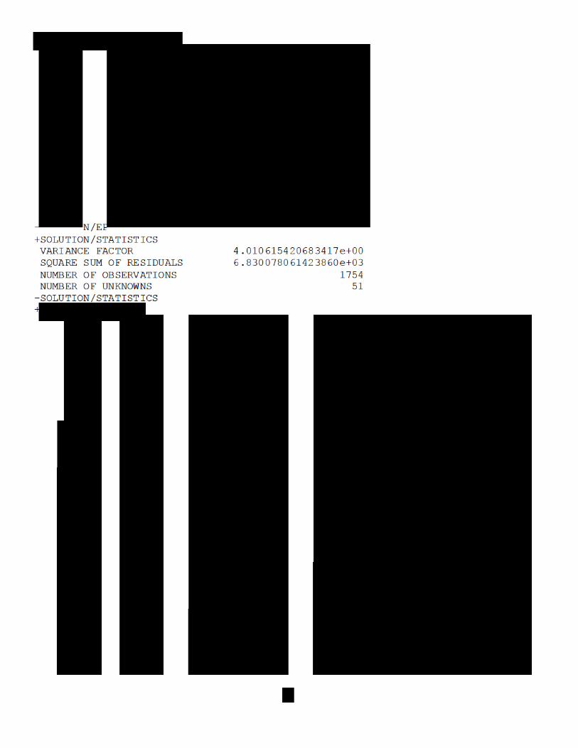


51
+SOLUTION/MATRIX_ESTIMATE U COVA (cont.) 9 30 0.00000000000000e+00 0.00000000000000e+00 0.00000000000000e+00 9 33 0.00000000000000e+00 0.00000000000000e+00 0.00000000000000e+00 9 36 0.00000000000000e+00 0.00000000000000e+00 0.00000000000000e+00 9 39 0.00000000000000e+00 0.00000000000000e+00 0.00000000000000e+00 9 42 0.00000000000000e+00 0.00000000000000e+00 0.00000000000000e+00 9 45 0.00000000000000e+00 0.00000000000000e+00 0.00000000000000e+00 9 48 0.00000000000000e+00 0.00000000000000e+00 0.00000000000000e+00 9 51 0.00000000000000e+00 10 10 3.37256519961041e-08 1.66270101605384e-09 -1.66270589012745e-09 10 13 0.00000000000000e+00 0.00000000000000e+00 0.00000000000000e+00 10 16 0.00000000000000e+00 0.00000000000000e+00 0.00000000000000e+00 10 19 0.00000000000000e+00 0.00000000000000e+00 0.00000000000000e+00 10 22 0.00000000000000e+00 0.00000000000000e+00 0.00000000000000e+00 10 25 0.00000000000000e+00 0.00000000000000e+00 0.00000000000000e+00 10 28 0.00000000000000e+00 0.00000000000000e+00 0.00000000000000e+00 10 31 0.00000000000000e+00 0.00000000000000e+00 0.00000000000000e+00 10 34 0.00000000000000e+00 0.00000000000000e+00 0.00000000000000e+00 10 37 0.00000000000000e+00 0.00000000000000e+00 0.00000000000000e+00 10 40 0.00000000000000e+00 0.00000000000000e+00 0.00000000000000e+00 10 43 0.00000000000000e+00 0.00000000000000e+00 0.00000000000000e+00 10 46 0.00000000000000e+00 0.00000000000000e+00 0.00000000000000e+00 10 49 0.00000000000000e+00 0.00000000000000e+00 0.00000000000000e+00 11 11 2.31596753724408e-08 1.82793857522098e-09 0.00000000000000e+00 11 14 0.00000000000000e+00 0.00000000000000e+00 0.00000000000000e+00 11 17 0.00000000000000e+00 0.00000000000000e+00 0.00000000000000e+00 11 20 0.00000000000000e+00 0.00000000000000e+00 0.00000000000000e+00 11 23 0.00000000000000e+00 0.00000000000000e+00 0.00000000000000e+00 11 26 0.00000000000000e+00 0.00000000000000e+00 0.00000000000000e+00 11 29 0.00000000000000e+00 0.00000000000000e+00 0.00000000000000e+00 11 32 0.00000000000000e+00 0.00000000000000e+00 0.00000000000000e+00 11 35 0.00000000000000e+00 0.00000000000000e+00 0.00000000000000e+00 11 38 0.00000000000000e+00 0.00000000000000e+00 0.00000000000000e+00 11 41 0.00000000000000e+00 0.00000000000000e+00 0.00000000000000e+00 11 44 0.00000000000000e+00 0.00000000000000e+00 0.00000000000000e+00 11 47 0.00000000000000e+00 0.00000000000000e+00 0.00000000000000e+00 11 50 0.00000000000000e+00 0.00000000000000e+00 12 12 2.29208317380224e-08 0.00000000000000e+00 0.00000000000000e+00 12 15 0.00000000000000e+00 0.00000000000000e+00 0.00000000000000e+00 12 18 0.00000000000000e+00 0.00000000000000e+00 0.00000000000000e+00 12 21 0.00000000000000e+00 0.00000000000000e+00 0.00000000000000e+00 12 24 0.00000000000000e+00 0.00000000000000e+00 0.00000000000000e+00 12 27 0.00000000000000e+00 0.00000000000000e+00 0.00000000000000e+00 12 30 0.00000000000000e+00 0.00000000000000e+00 0.00000000000000e+00 12 33 0.00000000000000e+00 0.00000000000000e+00 0.00000000000000e+00 12 36 0.00000000000000e+00 0.00000000000000e+00 0.00000000000000e+00 12 39 0.00000000000000e+00 0.00000000000000e+00 0.00000000000000e+00 12 42 0.00000000000000e+00 0.00000000000000e+00 0.00000000000000e+00 12 45 0.00000000000000e+00 0.00000000000000e+00 0.00000000000000e+00 12 48 0.00000000000000e+00 0.00000000000000e+00 0.00000000000000e+00 12 51 0.00000000000000e+00 13 13 2.61475469663190e-08 1.50845769954185e-09 -1.41254813859631e-09 13 16 0.00000000000000e+00 0.00000000000000e+00 0.00000000000000e+00 13 19 0.00000000000000e+00 0.00000000000000e+00 0.00000000000000e+00
52
+SOLUTION/MATRIX_ESTIMATE U COVA (cont.) 13 22 0.00000000000000e+00 0.00000000000000e+00 0.00000000000000e+00 13 25 0.00000000000000e+00 0.00000000000000e+00 0.00000000000000e+00 13 28 0.00000000000000e+00 0.00000000000000e+00 0.00000000000000e+00 13 31 0.00000000000000e+00 0.00000000000000e+00 0.00000000000000e+00 13 34 0.00000000000000e+00 0.00000000000000e+00 0.00000000000000e+00 13 37 0.00000000000000e+00 0.00000000000000e+00 0.00000000000000e+00 13 40 0.00000000000000e+00 0.00000000000000e+00 0.00000000000000e+00 13 43 0.00000000000000e+00 0.00000000000000e+00 0.00000000000000e+00 13 46 0.00000000000000e+00 0.00000000000000e+00 0.00000000000000e+00 13 49 0.00000000000000e+00 0.00000000000000e+00 0.00000000000000e+00 14 14 2.01516022842364e-08 3.54870485949648e-09 0.00000000000000e+00 14 17 0.00000000000000e+00 0.00000000000000e+00 0.00000000000000e+00 14 20 0.00000000000000e+00 0.00000000000000e+00 0.00000000000000e+00 14 23 0.00000000000000e+00 0.00000000000000e+00 0.00000000000000e+00 14 26 0.00000000000000e+00 0.00000000000000e+00 0.00000000000000e+00 14 29 0.00000000000000e+00 0.00000000000000e+00 0.00000000000000e+00 14 32 0.00000000000000e+00 0.00000000000000e+00 0.00000000000000e+00 14 35 0.00000000000000e+00 0.00000000000000e+00 0.00000000000000e+00 14 38 0.00000000000000e+00 0.00000000000000e+00 0.00000000000000e+00 14 41 0.00000000000000e+00 0.00000000000000e+00 0.00000000000000e+00 14 44 0.00000000000000e+00 0.00000000000000e+00 0.00000000000000e+00 14 47 0.00000000000000e+00 0.00000000000000e+00 0.00000000000000e+00 14 50 0.00000000000000e+00 0.00000000000000e+00 15 15 2.26144380224738e-08 0.00000000000000e+00 0.00000000000000e+00 15 18 0.00000000000000e+00 0.00000000000000e+00 0.00000000000000e+00 15 21 0.00000000000000e+00 0.00000000000000e+00 0.00000000000000e+00 15 24 0.00000000000000e+00 0.00000000000000e+00 0.00000000000000e+00 15 27 0.00000000000000e+00 0.00000000000000e+00 0.00000000000000e+00 15 30 0.00000000000000e+00 0.00000000000000e+00 0.00000000000000e+00 15 33 0.00000000000000e+00 0.00000000000000e+00 0.00000000000000e+00 15 36 0.00000000000000e+00 0.00000000000000e+00 0.00000000000000e+00 15 39 0.00000000000000e+00 0.00000000000000e+00 0.00000000000000e+00 15 42 0.00000000000000e+00 0.00000000000000e+00 0.00000000000000e+00 15 45 0.00000000000000e+00 0.00000000000000e+00 0.00000000000000e+00 15 48 0.00000000000000e+00 0.00000000000000e+00 0.00000000000000e+00 15 51 0.00000000000000e+00 16 16 2.74840569247744e-08 -3.04128592632355e-11 -2.32004929752815e-09 16 19 0.00000000000000e+00 0.00000000000000e+00 0.00000000000000e+00 16 22 0.00000000000000e+00 0.00000000000000e+00 0.00000000000000e+00 16 25 0.00000000000000e+00 0.00000000000000e+00 0.00000000000000e+00 16 28 0.00000000000000e+00 0.00000000000000e+00 0.00000000000000e+00 16 31 0.00000000000000e+00 0.00000000000000e+00 0.00000000000000e+00 16 34 0.00000000000000e+00 0.00000000000000e+00 0.00000000000000e+00 16 37 0.00000000000000e+00 0.00000000000000e+00 0.00000000000000e+00 16 40 0.00000000000000e+00 0.00000000000000e+00 0.00000000000000e+00 16 43 0.00000000000000e+00 0.00000000000000e+00 0.00000000000000e+00 16 46 0.00000000000000e+00 0.00000000000000e+00 0.00000000000000e+00 16 49 0.00000000000000e+00 0.00000000000000e+00 0.00000000000000e+00 17 17 2.08275667504701e-08 3.64156044382999e-09 0.00000000000000e+00 17 20 0.00000000000000e+00 0.00000000000000e+00 0.00000000000000e+00 17 23 0.00000000000000e+00 0.00000000000000e+00 0.00000000000000e+00 17 26 0.00000000000000e+00 0.00000000000000e+00 0.00000000000000e+00 17 29 0.00000000000000e+00 0.00000000000000e+00 0.00000000000000e+00
53
+SOLUTION/MATRIX_ESTIMATE U COVA (cont.) 17 32 0.00000000000000e+00 0.00000000000000e+00 0.00000000000000e+00 17 35 0.00000000000000e+00 0.00000000000000e+00 0.00000000000000e+00 17 38 0.00000000000000e+00 0.00000000000000e+00 0.00000000000000e+00 17 41 0.00000000000000e+00 0.00000000000000e+00 0.00000000000000e+00 17 44 0.00000000000000e+00 0.00000000000000e+00 0.00000000000000e+00 17 47 0.00000000000000e+00 0.00000000000000e+00 0.00000000000000e+00 17 50 0.00000000000000e+00 0.00000000000000e+00 18 18 2.37076033284918e-08 0.00000000000000e+00 0.00000000000000e+00 18 21 0.00000000000000e+00 0.00000000000000e+00 0.00000000000000e+00 18 24 0.00000000000000e+00 0.00000000000000e+00 0.00000000000000e+00 18 27 0.00000000000000e+00 0.00000000000000e+00 0.00000000000000e+00 18 30 0.00000000000000e+00 0.00000000000000e+00 0.00000000000000e+00 18 33 0.00000000000000e+00 0.00000000000000e+00 0.00000000000000e+00 18 36 0.00000000000000e+00 0.00000000000000e+00 0.00000000000000e+00 18 39 0.00000000000000e+00 0.00000000000000e+00 0.00000000000000e+00 18 42 0.00000000000000e+00 0.00000000000000e+00 0.00000000000000e+00 18 45 0.00000000000000e+00 0.00000000000000e+00 0.00000000000000e+00 18 48 0.00000000000000e+00 0.00000000000000e+00 0.00000000000000e+00 18 51 0.00000000000000e+00 19 19 1.22238145056833e-08 -5.80109822146928e-10 -3.86782335559721e-10 19 22 0.00000000000000e+00 0.00000000000000e+00 0.00000000000000e+00 19 25 0.00000000000000e+00 0.00000000000000e+00 0.00000000000000e+00 19 28 0.00000000000000e+00 0.00000000000000e+00 0.00000000000000e+00 19 31 0.00000000000000e+00 0.00000000000000e+00 0.00000000000000e+00 19 34 0.00000000000000e+00 0.00000000000000e+00 0.00000000000000e+00 19 37 0.00000000000000e+00 0.00000000000000e+00 0.00000000000000e+00 19 40 0.00000000000000e+00 0.00000000000000e+00 0.00000000000000e+00 19 43 0.00000000000000e+00 0.00000000000000e+00 0.00000000000000e+00 19 46 0.00000000000000e+00 0.00000000000000e+00 0.00000000000000e+00 19 49 1.23217047611783e-08 2.55974207892751e-10 -1.61470113153305e-09 20 20 1.22940864110389e-08 -9.29304468089578e-10 0.00000000000000e+00 20 23 0.00000000000000e+00 0.00000000000000e+00 0.00000000000000e+00 20 26 0.00000000000000e+00 0.00000000000000e+00 0.00000000000000e+00 20 29 0.00000000000000e+00 0.00000000000000e+00 0.00000000000000e+00 20 32 0.00000000000000e+00 0.00000000000000e+00 0.00000000000000e+00 20 35 0.00000000000000e+00 0.00000000000000e+00 0.00000000000000e+00 20 38 0.00000000000000e+00 0.00000000000000e+00 0.00000000000000e+00 20 41 0.00000000000000e+00 0.00000000000000e+00 0.00000000000000e+00 20 44 0.00000000000000e+00 0.00000000000000e+00 0.00000000000000e+00 20 47 0.00000000000000e+00 0.00000000000000e+00 4.13246073612486e-11 20 50 8.12336131783601e-09 2.43646888477646e-09 21 21 1.23639488797906e-08 0.00000000000000e+00 0.00000000000000e+00 21 24 0.00000000000000e+00 0.00000000000000e+00 0.00000000000000e+00 21 27 0.00000000000000e+00 0.00000000000000e+00 0.00000000000000e+00 21 30 0.00000000000000e+00 0.00000000000000e+00 0.00000000000000e+00 21 33 0.00000000000000e+00 0.00000000000000e+00 0.00000000000000e+00 21 36 0.00000000000000e+00 0.00000000000000e+00 0.00000000000000e+00 21 39 0.00000000000000e+00 0.00000000000000e+00 0.00000000000000e+00 21 42 0.00000000000000e+00 0.00000000000000e+00 0.00000000000000e+00 21 45 0.00000000000000e+00 0.00000000000000e+00 0.00000000000000e+00 21 48 0.00000000000000e+00 -1.26864922041239e-09 2.68080604776848e-09 21 51 9.93817708453892e-09 22 22 4.00379278045372e-08 1.06767425952734e-09 -2.86678915546673e-09
54
+SOLUTION/MATRIX_ESTIMATE U COVA (cont.) 22 25 0.00000000000000e+00 0.00000000000000e+00 0.00000000000000e+00 22 28 0.00000000000000e+00 0.00000000000000e+00 0.00000000000000e+00 22 31 0.00000000000000e+00 0.00000000000000e+00 0.00000000000000e+00 22 34 0.00000000000000e+00 0.00000000000000e+00 0.00000000000000e+00 22 37 0.00000000000000e+00 0.00000000000000e+00 0.00000000000000e+00 22 40 0.00000000000000e+00 0.00000000000000e+00 0.00000000000000e+00 22 43 0.00000000000000e+00 0.00000000000000e+00 0.00000000000000e+00 22 46 0.00000000000000e+00 0.00000000000000e+00 0.00000000000000e+00 22 49 0.00000000000000e+00 0.00000000000000e+00 0.00000000000000e+00 23 23 3.05372546353731e-08 6.33016728130800e-09 0.00000000000000e+00 23 26 0.00000000000000e+00 0.00000000000000e+00 0.00000000000000e+00 23 29 0.00000000000000e+00 0.00000000000000e+00 0.00000000000000e+00 23 32 0.00000000000000e+00 0.00000000000000e+00 0.00000000000000e+00 23 35 0.00000000000000e+00 0.00000000000000e+00 0.00000000000000e+00 23 38 0.00000000000000e+00 0.00000000000000e+00 0.00000000000000e+00 23 41 0.00000000000000e+00 0.00000000000000e+00 0.00000000000000e+00 23 44 0.00000000000000e+00 0.00000000000000e+00 0.00000000000000e+00 23 47 0.00000000000000e+00 0.00000000000000e+00 0.00000000000000e+00 23 50 0.00000000000000e+00 0.00000000000000e+00 24 24 3.28356430055351e-08 0.00000000000000e+00 0.00000000000000e+00 24 27 0.00000000000000e+00 0.00000000000000e+00 0.00000000000000e+00 24 30 0.00000000000000e+00 0.00000000000000e+00 0.00000000000000e+00 24 33 0.00000000000000e+00 0.00000000000000e+00 0.00000000000000e+00 24 36 0.00000000000000e+00 0.00000000000000e+00 0.00000000000000e+00 24 39 0.00000000000000e+00 0.00000000000000e+00 0.00000000000000e+00 24 42 0.00000000000000e+00 0.00000000000000e+00 0.00000000000000e+00 24 45 0.00000000000000e+00 0.00000000000000e+00 0.00000000000000e+00 24 48 0.00000000000000e+00 0.00000000000000e+00 0.00000000000000e+00 24 51 0.00000000000000e+00 25 25 4.09468748691871e-08 -5.79602986438699e-09 1.12726420415325e-08 25 28 0.00000000000000e+00 0.00000000000000e+00 0.00000000000000e+00 25 31 0.00000000000000e+00 0.00000000000000e+00 0.00000000000000e+00 25 34 0.00000000000000e+00 0.00000000000000e+00 0.00000000000000e+00 25 37 0.00000000000000e+00 0.00000000000000e+00 0.00000000000000e+00 25 40 0.00000000000000e+00 0.00000000000000e+00 0.00000000000000e+00 25 43 0.00000000000000e+00 0.00000000000000e+00 0.00000000000000e+00 25 46 0.00000000000000e+00 0.00000000000000e+00 0.00000000000000e+00 25 49 0.00000000000000e+00 0.00000000000000e+00 0.00000000000000e+00 26 26 7.01904593798533e-08 -4.11219238399588e-08 0.00000000000000e+00 26 29 0.00000000000000e+00 0.00000000000000e+00 0.00000000000000e+00 26 32 0.00000000000000e+00 0.00000000000000e+00 0.00000000000000e+00 26 35 0.00000000000000e+00 0.00000000000000e+00 0.00000000000000e+00 26 38 0.00000000000000e+00 0.00000000000000e+00 0.00000000000000e+00 26 41 0.00000000000000e+00 0.00000000000000e+00 0.00000000000000e+00 26 44 0.00000000000000e+00 0.00000000000000e+00 0.00000000000000e+00 26 47 0.00000000000000e+00 0.00000000000000e+00 0.00000000000000e+00 26 50 0.00000000000000e+00 0.00000000000000e+00 27 27 5.32200501398669e-08 0.00000000000000e+00 0.00000000000000e+00 27 30 0.00000000000000e+00 0.00000000000000e+00 0.00000000000000e+00 27 33 0.00000000000000e+00 0.00000000000000e+00 0.00000000000000e+00 27 36 0.00000000000000e+00 0.00000000000000e+00 0.00000000000000e+00 27 39 0.00000000000000e+00 0.00000000000000e+00 0.00000000000000e+00 27 42 0.00000000000000e+00 0.00000000000000e+00 0.00000000000000e+00
55
+SOLUTION/MATRIX_ESTIMATE U COVA (cont.) 27 45 0.00000000000000e+00 0.00000000000000e+00 0.00000000000000e+00 27 48 0.00000000000000e+00 0.00000000000000e+00 0.00000000000000e+00 27 51 0.00000000000000e+00 28 28 3.35657780000256e-08 2.61084508112119e-09 1.72936111642470e-09 28 31 0.00000000000000e+00 0.00000000000000e+00 0.00000000000000e+00 28 34 0.00000000000000e+00 0.00000000000000e+00 0.00000000000000e+00 28 37 0.00000000000000e+00 0.00000000000000e+00 0.00000000000000e+00 28 40 0.00000000000000e+00 0.00000000000000e+00 0.00000000000000e+00 28 43 0.00000000000000e+00 0.00000000000000e+00 0.00000000000000e+00 28 46 0.00000000000000e+00 0.00000000000000e+00 0.00000000000000e+00 28 49 0.00000000000000e+00 0.00000000000000e+00 0.00000000000000e+00 29 29 3.13845982051817e-08 3.03867378968025e-09 0.00000000000000e+00 29 32 0.00000000000000e+00 0.00000000000000e+00 0.00000000000000e+00 29 35 0.00000000000000e+00 0.00000000000000e+00 0.00000000000000e+00 29 38 0.00000000000000e+00 0.00000000000000e+00 0.00000000000000e+00 29 41 0.00000000000000e+00 0.00000000000000e+00 0.00000000000000e+00 29 44 0.00000000000000e+00 0.00000000000000e+00 0.00000000000000e+00 29 47 0.00000000000000e+00 0.00000000000000e+00 0.00000000000000e+00 29 50 0.00000000000000e+00 0.00000000000000e+00 30 30 3.15358682742791e-08 0.00000000000000e+00 0.00000000000000e+00 30 33 0.00000000000000e+00 0.00000000000000e+00 0.00000000000000e+00 30 36 0.00000000000000e+00 0.00000000000000e+00 0.00000000000000e+00 30 39 0.00000000000000e+00 0.00000000000000e+00 0.00000000000000e+00 30 42 0.00000000000000e+00 0.00000000000000e+00 0.00000000000000e+00 30 45 0.00000000000000e+00 0.00000000000000e+00 0.00000000000000e+00 30 48 0.00000000000000e+00 0.00000000000000e+00 0.00000000000000e+00 30 51 0.00000000000000e+00 31 31 3.51996686459344e-08 2.80968694149376e-10 -3.42003309194295e-09 31 34 0.00000000000000e+00 0.00000000000000e+00 0.00000000000000e+00 31 37 0.00000000000000e+00 0.00000000000000e+00 0.00000000000000e+00 31 40 0.00000000000000e+00 0.00000000000000e+00 0.00000000000000e+00 31 43 0.00000000000000e+00 0.00000000000000e+00 0.00000000000000e+00 31 46 0.00000000000000e+00 0.00000000000000e+00 0.00000000000000e+00 31 49 0.00000000000000e+00 0.00000000000000e+00 0.00000000000000e+00 32 32 2.13427564894343e-08 -1.59305670902080e-10 0.00000000000000e+00 32 35 0.00000000000000e+00 0.00000000000000e+00 0.00000000000000e+00 32 38 0.00000000000000e+00 0.00000000000000e+00 0.00000000000000e+00 32 41 0.00000000000000e+00 0.00000000000000e+00 0.00000000000000e+00 32 44 0.00000000000000e+00 0.00000000000000e+00 0.00000000000000e+00 32 47 0.00000000000000e+00 0.00000000000000e+00 0.00000000000000e+00 32 50 0.00000000000000e+00 0.00000000000000e+00 33 33 2.23659033190205e-08 0.00000000000000e+00 0.00000000000000e+00 33 36 0.00000000000000e+00 0.00000000000000e+00 0.00000000000000e+00 33 39 0.00000000000000e+00 0.00000000000000e+00 0.00000000000000e+00 33 42 0.00000000000000e+00 0.00000000000000e+00 0.00000000000000e+00 33 45 0.00000000000000e+00 0.00000000000000e+00 0.00000000000000e+00 33 48 0.00000000000000e+00 0.00000000000000e+00 0.00000000000000e+00 33 51 0.00000000000000e+00 34 34 4.97188313627986e-08 9.65013868169275e-09 5.73819502498763e-09 34 37 0.00000000000000e+00 0.00000000000000e+00 0.00000000000000e+00 34 40 0.00000000000000e+00 0.00000000000000e+00 0.00000000000000e+00 34 43 0.00000000000000e+00 0.00000000000000e+00 0.00000000000000e+00 34 46 0.00000000000000e+00 0.00000000000000e+00 0.00000000000000e+00
56
+SOLUTION/MATRIX_ESTIMATE U COVA (cont.) 34 49 0.00000000000000e+00 0.00000000000000e+00 0.00000000000000e+00 35 35 3.73872125591970e-08 7.89387316581598e-09 0.00000000000000e+00 35 38 0.00000000000000e+00 0.00000000000000e+00 0.00000000000000e+00 35 41 0.00000000000000e+00 0.00000000000000e+00 0.00000000000000e+00 35 44 0.00000000000000e+00 0.00000000000000e+00 0.00000000000000e+00 35 47 0.00000000000000e+00 0.00000000000000e+00 0.00000000000000e+00 35 50 0.00000000000000e+00 0.00000000000000e+00 36 36 3.65954291605269e-08 0.00000000000000e+00 0.00000000000000e+00 36 39 0.00000000000000e+00 0.00000000000000e+00 0.00000000000000e+00 36 42 0.00000000000000e+00 0.00000000000000e+00 0.00000000000000e+00 36 45 0.00000000000000e+00 0.00000000000000e+00 0.00000000000000e+00 36 48 0.00000000000000e+00 0.00000000000000e+00 0.00000000000000e+00 36 51 0.00000000000000e+00 37 37 8.18403520130405e-09 -2.20402729426811e-08 1.91734201929704e-08 37 40 0.00000000000000e+00 0.00000000000000e+00 0.00000000000000e+00 37 43 0.00000000000000e+00 0.00000000000000e+00 0.00000000000000e+00 37 46 0.00000000000000e+00 0.00000000000000e+00 0.00000000000000e+00 37 49 0.00000000000000e+00 0.00000000000000e+00 0.00000000000000e+00 38 38 1.01359967861880e-07 -8.16528930729892e-08 0.00000000000000e+00 38 41 0.00000000000000e+00 0.00000000000000e+00 0.00000000000000e+00 38 44 0.00000000000000e+00 0.00000000000000e+00 0.00000000000000e+00 38 47 0.00000000000000e+00 0.00000000000000e+00 0.00000000000000e+00 38 50 0.00000000000000e+00 0.00000000000000e+00 39 39 7.09675727450631e-08 0.00000000000000e+00 0.00000000000000e+00 39 42 0.00000000000000e+00 0.00000000000000e+00 0.00000000000000e+00 39 45 0.00000000000000e+00 0.00000000000000e+00 0.00000000000000e+00 39 48 0.00000000000000e+00 0.00000000000000e+00 0.00000000000000e+00 39 51 0.00000000000000e+00 40 40 4.99907403473670e-08 8.46487756155133e-09 6.72978337095067e-09 40 43 0.00000000000000e+00 0.00000000000000e+00 0.00000000000000e+00 40 46 0.00000000000000e+00 0.00000000000000e+00 0.00000000000000e+00 40 49 0.00000000000000e+00 0.00000000000000e+00 0.00000000000000e+00 41 41 4.24638197444933e-08 3.67532210434000e-09 0.00000000000000e+00 41 44 0.00000000000000e+00 0.00000000000000e+00 0.00000000000000e+00 41 47 0.00000000000000e+00 0.00000000000000e+00 0.00000000000000e+00 41 50 0.00000000000000e+00 0.00000000000000e+00 42 42 4.01130904245325e-08 0.00000000000000e+00 0.00000000000000e+00 42 45 0.00000000000000e+00 0.00000000000000e+00 0.00000000000000e+00 42 48 0.00000000000000e+00 0.00000000000000e+00 0.00000000000000e+00 42 51 0.00000000000000e+00 43 43 6.64990838832821e-09 -1.33757505771841e-08 1.01334243859420e-08 43 46 0.00000000000000e+00 0.00000000000000e+00 0.00000000000000e+00 43 49 0.00000000000000e+00 0.00000000000000e+00 0.00000000000000e+00 44 44 6.07661822559411e-08 -4.43333485194568e-08 0.00000000000000e+00 44 47 0.00000000000000e+00 0.00000000000000e+00 0.00000000000000e+00 44 50 0.00000000000000e+00 0.00000000000000e+00 45 45 4.50371748419833e-08 0.00000000000000e+00 0.00000000000000e+00 45 48 0.00000000000000e+00 0.00000000000000e+00 0.00000000000000e+00 45 51 0.00000000000000e+00 46 46 5.63040997012904e-09 -4.66224682955069e-09 3.08576968990022e-09 46 49 0.00000000000000e+00 0.00000000000000e+00 0.00000000000000e+00 47 47 2.33275650555910e-08 -1.64612456675990e-08 0.00000000000000e+00 47 50 0.00000000000000e+00 0.00000000000000e+00
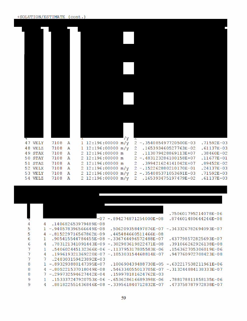
61
+SOLUTION/MATRIX_ESTIMATE L COVA (cont.) *PARA1 PARA2 ____PARA2+0__________ ____PARA2+1__________ ____PARA2+2__________ 19 19 .213213638545624E-05 20 1 -.963982703683532E-07 .971568084042687E-06 -.647061214298981E-06 20 4 -.864656633017267E-08 .525727936889298E-07 -.323890657352015E-07 20 7 -.108710634826358E-06 .105604361992354E-05 -.635561733800245E-06 20 10 -.864676362146940E-08 .527030826745019E-07 -.323879927835408E-07 20 13 -.940034516443555E-07 .919113399473517E-06 -.656469899549192E-06 20 16 -.864663641976182E-08 .528329103068561E-07 -.323876928928241E-07 20 19 -.633966666291032E-07 .223441414981916E-05 21 1 .152250239949836E-06 -.659018534122933E-06 .762123223264226E-06 21 4 .867037128849919E-08 -.342691874114821E-07 .458728740977419E-07 21 7 .155063448096067E-06 -.626811924896319E-06 .828197705033729E-06 21 10 .867023369945012E-08 -.342691410507295E-07 .460039129196952E-07 21 13 .155503236345388E-06 -.682817035884504E-06 .717348519422349E-06 21 16 .866981039892762E-08 -.342685634541973E-07 .461356366526707E-07 21 19 -.224372096689881E-07 -.164886260589808E-06 .180692704400701E-05 22 1 .157169423356815E-07 -.894259510596844E-08 .874586881798111E-08 22 4 .140681294050520E-08 -.815216364542433E-09 .783107250502123E-09 22 7 .201715312421969E-07 -.805216912209794E-08 .881807427701101E-08 22 10 .141458439109970E-08 -.815218900493033E-09 .783099439188189E-09 22 13 .135585490259809E-07 -.954269464843543E-08 .892543436307251E-08 22 16 .142234705906530E-08 -.815211832934370E-09 .783111735525907E-09 22 19 .183563449958596E-07 -.864631898210292E-08 .866886932501856E-08 22 22 .143787362689215E-08 23 1 -.940582292868666E-08 .506207005067424E-07 -.343326951477147E-07 23 4 -.815234953399386E-09 .445483020375192E-08 -.302983904074788E-08 23 7 -.105304992987150E-07 .548430370054176E-07 -.339561386786658E-07 23 10 -.815254642216114E-09 .446260773262421E-08 -.302981344167186E-08 23 13 -.897715671859589E-08 .481606098108236E-07 -.347114760628029E-07 23 16 -.815246880916305E-09 .447034138609520E-08 -.302985940141796E-08 23 19 -.962133574442320E-08 .530934112971428E-07 -.342683505225832E-07 23 22 -.815221586545958E-09 .448588746860929E-08 24 1 .905418657853765E-08 -.336765041992967E-07 .437796457136603E-07 24 4 .783123922946637E-09 -.302984209274085E-08 .391065090551492E-08 24 7 .947769996630330E-08 -.313244988525373E-07 .475852325967141E-07 24 10 .783141245213979E-09 -.302985747667696E-08 .391839267372256E-08 24 13 .916042696165395E-08 -.356114363839979E-07 .410008540126823E-07 24 16 .783133988320713E-09 -.302982505686009E-08 .392619488094326E-08 24 19 .881808785867601E-08 -.323859223281967E-07 .463980896458257E-07 24 22 .783109799839332E-09 -.302984419845434E-08 .394171153307314E-08 25 1 .205236790216571E-06 -.247118990115517E-06 .220000327968499E-06 25 4 .143540530509958E-07 -.889101109252036E-08 .865879487342832E-08 25 7 .250937319436679E-06 -.237031358736578E-06 .222195883663565E-06 25 10 .143540928951806E-07 -.889103403726355E-08 .865871790925392E-08 25 13 .182119640807929E-06 -.252895395359328E-06 .221252682977428E-06 25 16 .143540045894240E-07 -.889095706297100E-08 .865884549825850E-08 25 19 .225461903080647E-06 -.243995159109810E-06 .219626794098427E-06 25 22 .143538923330453E-07 -.889105937605803E-08 .865881040404516E-08 25 25 .527944619044075E-06 26 1 -.195610850983823E-07 .748368810477448E-06 -.511172859887893E-06 26 4 -.950191965497477E-08 .504509528445222E-07 -.349404503303732E-07 26 7 -.350270239564814E-07 .794939019362509E-06 -.507574906689904E-06 26 10 -.950215010334005E-08 .504510547980744E-07 -.349401583174590E-07
62
+SOLUTION/MATRIX_ESTIMATE L COVA (cont.) *PARA1 PARA2 ____PARA2+0__________ ____PARA2+1__________ ____PARA2+2__________ 26 13 -.139958118057662E-07 .718994957258890E-06 -.514810499477564E-06 26 16 -.950205768854084E-08 .504506440446383E-07 -.349406703339660E-07 26 19 -.244751567109460E-07 .769547656134325E-06 -.510063625208311E-06 26 22 -.950177694200628E-08 .504507454045062E-07 -.349404909923356E-07 26 25 -.153897853427100E-06 .114108026782715E-05 27 1 .151172103743533E-06 -.632216822618826E-06 .692873208291583E-06 27 4 .925337307593235E-08 -.348889027941589E-07 .428961146404375E-07 27 7 .158330483469872E-06 -.608754735748951E-06 .731912676026269E-06 27 10 .925356807844771E-08 -.348890674063489E-07 .428958081267299E-07 27 13 .152693961241359E-06 -.649421445976222E-06 .662281215147411E-06 27 16 .925349017373805E-08 -.348887018357155E-07 .428961888372419E-07 27 19 .149227140765385E-06 -.620044367720140E-06 .714061041986957E-06 27 22 .925322056143853E-08 -.348889069265016E-07 .428959553745490E-07 27 25 .267334030670525E-06 -.588392073645151E-06 .977987421171784E-06 28 1 .150836242816109E-07 -.904762316012595E-08 .876761537458994E-08 28 4 .135168432017892E-08 -.825941091976405E-09 .786032663264631E-09 28 7 .190082887738934E-07 -.815434689472539E-08 .884911732007017E-08 28 10 .135168734748473E-08 -.825943699470900E-09 .786024808049281E-09 28 13 .129159396647770E-07 -.964079278573879E-08 .894246880352153E-08 28 16 .135168188271767E-08 -.825936595379677E-09 .786037175994723E-09 28 19 .171044211296989E-07 -.875364652307599E-08 .869720564601068E-08 28 22 .135167163667591E-08 -.825946182984708E-09 .786035236024255E-09 28 25 .146978080317961E-07 -.963151638086639E-08 .929755486787141E-08 28 28 .138432990295196E-08 29 1 -.932214300496595E-08 .501001971783616E-07 -.342103750987662E-07 29 4 -.807571087890405E-09 .440901513923929E-08 -.301669392484082E-08 29 7 -.104567149832808E-07 .538732228339796E-07 -.339091424244408E-07 29 10 -.807590645611340E-09 .440902436693964E-08 -.301666863983047E-08 29 13 -.888465729893295E-08 .476452332943500E-07 -.345524308316087E-07 29 16 -.807582853173490E-09 .440899014349574E-08 -.301671450242598E-08 29 19 -.953890467304442E-08 .519691062536467E-07 -.341747360015541E-07 29 22 -.807557691424703E-09 .440899976399877E-08 -.301669965714979E-08 29 25 -.882196069012601E-08 .509338961065863E-07 -.347834808981910E-07 29 28 -.818268528616095E-09 .445090438401679E-08 30 1 .904663964069070E-08 -.338306777188100E-07 .433839620767172E-07 30 4 .781851097538094E-09 -.304279520928032E-08 .387731892597905E-08 30 7 .946944562115804E-08 -.316022999911416E-07 .467240885305572E-07 30 10 .781868379175137E-09 -.304281072421440E-08 .387729302659495E-08 30 13 .914445949838239E-08 -.356993480941098E-07 .406394791162239E-07 30 16 .781861235823564E-09 -.304277854632464E-08 .387732761663613E-08 30 19 .881909373756650E-08 -.325909143710244E-07 .453748050493316E-07 30 22 .781837075314013E-09 -.304279796702755E-08 .387730899394833E-08 30 25 .867332003992506E-08 -.351027427727497E-07 .434871328356320E-07 30 28 .784672898681686E-09 -.302975229991071E-08 .393023332498107E-08 31 1 .203028221163304E-06 -.245690962478632E-06 .218262637133094E-06 31 4 .141585441008094E-07 -.876467525637109E-08 .850143527809970E-08 31 7 .247852257701592E-06 -.234965046030293E-06 .219980365326113E-06 31 10 .141585836270523E-07 -.876469868602054E-08 .850136006870470E-08 31 13 .180126959216436E-06 -.251708380470373E-06 .219796495823627E-06 31 16 .141584967384845E-07 -.876462410283812E-08 .850148810078193E-08 31 19 .222988866929713E-06 -.242371228449151E-06 .217692332848576E-06 31 22 .141583860398818E-07 -.876472726582773E-08 .850145583592026E-08
63
+SOLUTION/MATRIX_ESTIMATE L COVA (cont.) *PARA1 PARA2 ____PARA2+0__________ ____PARA2+1__________ ____PARA2+2__________ 31 25 .511832404057029E-06 -.131785896738755E-06 .249714349127525E-06 31 28 .144902967799441E-07 -.868763071733716E-08 .850516735127809E-08 31 31 .511393125591161E-06 32 1 -.148764741843984E-07 .739994408577949E-06 -.502863704326600E-06 32 4 -.907413900205471E-08 .497019837926377E-07 -.341794124197492E-07 32 7 -.291345389717418E-07 .783244515233335E-06 -.497137115246669E-06 32 10 -.907436646683830E-08 .497020876219983E-07 -.341791290510458E-07 32 13 -.945169714161076E-08 .711975468791266E-06 -.507758836462767E-06 32 16 -.907427677120068E-08 .497016889759273E-07 -.341796420543230E-07 32 19 -.194330644728439E-07 .760111845275145E-06 -.500862214582584E-06 32 22 -.907400042023584E-08 .497017963404763E-07 -.341794757828235E-07 32 25 -.128984313065617E-06 .103058826285068E-05 -.508685074747895E-06 32 28 -.919389460393713E-08 .501387915857634E-07 -.342933575948302E-07 32 31 -.129881836015149E-06 .103330004711931E-05 33 1 .147732568444725E-06 -.627036761483243E-06 .685769738146516E-06 33 4 .893695194203065E-08 -.344212155720115E-07 .422553017142392E-07 33 7 .153966863813056E-06 -.601732729358085E-06 .722433788681970E-06 33 10 .893714477612400E-08 -.344213812720662E-07 .422550025364682E-07 33 13 .149350341589168E-06 -.644935442381415E-06 .656539448744779E-06 33 16 .893706921992461E-08 -.344210241696373E-07 .422553854733112E-07 33 19 .145534448720320E-06 -.614306931322837E-06 .705972538769393E-06 33 22 .893680280091576E-08 -.344212329663640E-07 .422551640179693E-07 33 25 .248377961363621E-06 -.511778209743296E-06 .904171726726204E-06 33 28 .897352598199131E-08 -.342887549507573E-07 .427945021801498E-07 33 31 .248384512447420E-06 -.510957792678270E-06 .904104295741770E-06 34 1 .150836264336594E-07 -.904762276659837E-08 .876761534472480E-08 34 4 .135168449350699E-08 -.825941067246415E-09 .786032666903196E-09 34 7 .190082919326107E-07 -.815434653198069E-08 .884911732288799E-08 34 10 .135168752081237E-08 -.825943674740567E-09 .786024811687544E-09 34 13 .129159415212131E-07 -.964079240490077E-08 .894246876196692E-08 34 16 .135168205604396E-08 -.825936570649178E-09 .786037179632445E-09 34 19 .171044235894835E-07 -.875364612488900E-08 .869720560769747E-08 34 22 .135167181000109E-08 -.825946158254375E-09 .786035239661174E-09 34 25 .146914727125746E-07 -.963151693940582E-08 .929755517339798E-08 34 28 .138390629579059E-08 -.818268504060519E-09 .784672903211841E-09 34 31 .144902975915755E-07 -.919389420567830E-08 .897352587895630E-08 34 34 .138390647496787E-08 35 1 -.932214308349758E-08 .501001984628875E-07 -.342103753426018E-07 35 4 -.807571100450637E-09 .440901525852761E-08 -.301669395865678E-08 35 7 -.104567149960289E-07 .538732247261802E-07 -.339091424755177E-07 35 10 -.807590658172023E-09 .440902448622750E-08 -.301666867364548E-08 35 13 -.888465740806033E-08 .476452343045038E-07 -.345524311716356E-07 35 16 -.807582865734377E-09 .440899026278205E-08 -.301671453624115E-08 35 19 -.953890475798004E-08 .519691077504324E-07 -.341747361325123E-07 35 22 -.807557703985449E-09 .440899988328374E-08 -.301669969096376E-08 35 25 -.882196000666318E-08 .509275540957045E-07 -.347834790772035E-07 35 28 -.818268540747179E-09 .445048072059819E-08 -.302975233241880E-08 35 31 -.868763089234212E-08 .501387919883204E-07 -.342887552235888E-07 35 34 -.818268516455036E-09 .445048084460647E-08 36 1 .904663962761704E-08 -.338306771603065E-07 .433839629474749E-07 36 4 .781851100837084E-09 -.304279516917835E-08 .387731900359683E-08 36 7 .946944561966816E-08 -.316022990967998E-07 .467240900248624E-07
64
+SOLUTION/MATRIX_ESTIMATE L COVA (cont.) *PARA1 PARA2 ____PARA2+0__________ ____PARA2+1__________ ____PARA2+2__________ 36 10 .781868382474093E-09 -.304281068411295E-08 .387729310421283E-08 36 13 .914445950169561E-08 -.356993477032378E-07 .406394796413744E-07 36 16 .781861239122160E-09 -.304277850622350E-08 .387732769425388E-08 36 19 .881909368664045E-08 -.325909136819691E-07 .453748062409545E-07 36 22 .781837078612382E-09 -.304279792692739E-08 .387730907156607E-08 36 25 .867331875540464E-08 -.351027385655006E-07 .434807900827601E-07 36 28 .784672902062614E-09 -.302975225870516E-08 .392980962409259E-08 36 31 .850516733124003E-08 -.342933571810442E-07 .427945022873193E-07 36 34 .784672906751975E-09 -.302975229197241E-08 .392980971025266E-08 37 1 .202770988667733E-06 -.243676700439092E-06 .216688636290352E-06 37 4 .141490630121878E-07 -.863074217801613E-08 .839918077484284E-08 37 7 .247708144408502E-06 -.233007082329867E-06 .218472362256328E-06 37 10 .141491017870570E-07 -.863076502895488E-08 .839910625843793E-08 37 13 .179841422057490E-06 -.249678564619053E-06 .218183896868154E-06 37 16 .141490150096521E-07 -.863069150612881E-08 .839923254960472E-08 37 19 .222766708827511E-06 -.240374991419608E-06 .216146469895945E-06 37 22 .141489050316503E-07 -.863079397753567E-08 .839920043503996E-08 37 25 .511781136786575E-06 -.129843504162537E-06 .248347581771010E-06 37 28 .144815829821909E-07 -.855457953173261E-08 .840431344277691E-08 37 31 .510143225095127E-06 -.126291297224794E-06 .245756287390301E-06 37 34 .144815835707927E-07 -.855457971304812E-08 .840431342114016E-08 37 37 .510780564156479E-06 38 1 -.157539765930031E-07 .742244357164841E-06 -.504908002352628E-06 38 4 -.914633552259323E-08 .498823682640087E-07 -.343461584113064E-07 38 7 -.301567150073962E-07 .785886186023688E-06 -.499438199203867E-06 38 10 -.914656382997462E-08 .498824722092186E-07 -.343458734351126E-07 38 13 -.103098045789924E-07 .714071415884402E-06 -.509656203609887E-06 38 16 -.914647363311078E-08 .498820712984023E-07 -.343463873650501E-07 38 19 -.203521367564886E-07 .762489180690494E-06 -.503015035793942E-06 38 22 -.914619618358886E-08 .498821783480696E-07 -.343462192097656E-07 38 25 -.130063317145524E-06 .103447617634525E-05 -.511766756194624E-06 38 28 -.926723731322690E-08 .503240587196696E-07 -.344660861167357E-07 38 31 -.129303509667101E-06 .102956485623203E-05 -.508796340971447E-06 38 34 -.926723686809006E-08 .503240589527911E-07 -.344660856817960E-07 38 37 -.128513457395822E-06 .103923705516519E-05 39 1 .147919683674540E-06 -.626544018458307E-06 .685767727173777E-06 39 4 .896027023707383E-08 -.344051626804225E-07 .422776328322819E-07 39 7 .154273898975842E-06 -.601440396080946E-06 .722744944829025E-06 39 10 .896046295644127E-08 -.344053280054178E-07 .422773331505768E-07 39 13 .149520941395263E-06 -.644375272024399E-06 .656362979466946E-06 39 16 .896038724398415E-08 -.344049705136316E-07 .422777149640855E-07 39 19 .145753607673566E-06 -.613875581434289E-06 .706101474207646E-06 39 22 .896012086393135E-08 -.344051785861598E-07 .422774921951375E-07 39 25 .248692760615815E-06 -.512217038899840E-06 .905151659639888E-06 39 28 .899780584901887E-08 -.342760133921314E-07 .428228204303025E-07 39 31 .247431597250364E-06 -.506160566588522E-06 .900119704589879E-06 39 34 .899780570563213E-08 -.342760136279129E-07 .428228204053704E-07 39 37 .246905615101991E-06 -.513194760025559E-06 .904663329497973E-06 40 1 .150472728735311E-07 -.890029808930235E-08 .864545588438416E-08 40 4 .134853979735633E-08 -.813079865294950E-09 .775355002430484E-09 40 7 .189710772074605E-07 -.800623507428537E-08 .872699086514652E-08 40 10 .134854275594179E-08 -.813082426943180E-09 .775347226549149E-09
65
+SOLUTION/MATRIX_ESTIMATE L COVA (cont.) *PARA1 PARA2 ____PARA2+0__________ ____PARA2+1__________ ____PARA2+2__________ 40 13 .128796795652043E-07 -.949370577196132E-08 .882033025325688E-08 40 16 .134853731872662E-08 -.813075439389697E-09 .775359448081665E-09 40 19 .170679017005078E-07 -.860617064381335E-08 .857511587824265E-08 40 22 .134852715333219E-08 -.813084972483141E-09 .775357552598161E-09 40 25 .146552177970765E-07 -.948216143875860E-08 .917522077773790E-08 40 28 .138075874464056E-08 -.805402523973347E-09 .773992492297952E-09 40 31 .144558483091745E-07 -.904450799580123E-08 .885117759460375E-08 40 34 .138075892353206E-08 -.805402536365063E-09 .773992495926936E-09 40 37 .144512449573436E-07 -.911753795468518E-08 .887579636758056E-08 40 40 .137808411667420E-08 41 1 -.934376698645542E-08 .501918333940874E-07 -.342869979407302E-07 41 4 -.809441506165563E-09 .441701669972474E-08 -.302338729331183E-08 41 7 -.104783806443715E-07 .539647565330908E-07 -.339859356711350E-07 41 10 -.809461107060673E-09 .441702595667722E-08 -.302336195860408E-08 41 13 -.890636261237334E-08 .477369830719962E-07 -.346289472526600E-07 41 16 -.809453297900125E-09 .441699166113873E-08 -.302340791280731E-08 41 19 -.956047470037708E-08 .520606363137488E-07 -.342513879157942E-07 41 22 -.809428086237500E-09 .441700131662733E-08 -.302339303951106E-08 41 25 -.884289734234912E-08 .510195765024212E-07 -.348602778580476E-07 41 28 -.820137683044043E-09 .445848036489912E-08 -.303644733333576E-08 41 31 -.870852655819083E-08 .502324054179796E-07 -.343654726362062E-07 41 34 -.820137658771811E-09 .445848048875910E-08 -.303644729304785E-08 41 37 -.857509842162909E-08 .504213825693257E-07 -.343525603392315E-07 41 40 -.807239973224631E-09 .446692334136255E-08 42 1 .903013119611858E-08 -.337608076691051E-07 .433248343633506E-07 42 4 .780420458781646E-09 -.303669354978328E-08 .387215346185861E-08 42 7 .945292547438640E-08 -.315323761985940E-07 .466643473847280E-07 42 10 .780437707405495E-09 -.303670904267006E-08 .387212760129258E-08 42 13 .912785447004906E-08 -.356294302211758E-07 .405807055906748E-07 42 16 .780430576889504E-09 -.303667692039064E-08 .387216212268450E-08 42 19 .880263919993661E-08 -.325210910889724E-07 .453154584647415E-07 42 22 .780406454374551E-09 -.303669631511069E-08 .387214352337352E-08 42 25 .865740611640970E-08 -.350319305995208E-07 .434206128248598E-07 42 28 .783242979134273E-09 -.302364880183074E-08 .392463483736656E-08 42 31 .848922727947683E-08 -.342223785009340E-07 .427358912889228E-07 42 34 .783242983870442E-09 -.302364883527415E-08 .392463492328902E-08 42 37 .838867190505972E-08 -.343949874046424E-07 .427678584199750E-07 42 40 .772586887938163E-09 -.303032931385947E-08 .391989435426744E-08 43 1 .283437403610238E-06 -.214295598552899E-06 .210491797678914E-06 43 4 .136818368905192E-07 -.994603700844821E-08 .950786119561460E-08 43 7 .317955685970411E-06 -.204874883881304E-06 .213576851414453E-06 43 10 .136818912015137E-07 -.994605334173256E-08 .950777532100400E-08 43 13 .268255920675107E-06 -.218896667886113E-06 .210879804657628E-06 43 16 .136818082989237E-07 -.994597814029945E-08 .950792648369188E-08 43 19 .299883009284566E-06 -.210908961319838E-06 .209684239458673E-06 43 22 .136817077944260E-07 -.994608312688894E-08 .950789149976926E-08 43 25 .377923966195014E-06 -.144717475654121E-06 .246517431472090E-06 43 28 .139583958637901E-07 -.987495611415012E-08 .949968966157708E-08 43 31 .378319398613528E-06 -.144183215334839E-06 .246192098037640E-06 43 34 .139583953922277E-07 -.987495631108605E-08 .949968967526526E-08 43 37 .377797099740590E-06 -.144525332243380E-06 .245995556481487E-06 43 40 .139215149641014E-07 -.989845256186272E-08 .948176976906393E-08
66
+SOLUTION/MATRIX_ESTIMATE L COVA (cont.) *PARA1 PARA2 ____PARA2+0__________ ____PARA2+1__________ ____PARA2+2__________ 43 43 .170418007828418E-04 44 1 .461069832990536E-07 .599837316455380E-06 -.389276017688437E-06 44 4 -.661781496316281E-08 .411925008748602E-07 -.276867756673270E-07 44 7 .326707036867833E-07 .636882467883233E-06 -.390124406664188E-06 44 10 -.661800061669100E-08 .411925783704067E-07 -.276865473862355E-07 44 13 .494951503082904E-07 .573679517412287E-06 -.392426157022215E-06 44 16 -.661791384343280E-08 .411922657015207E-07 -.276869762224323E-07 44 19 .423055821202946E-07 .616230162218156E-06 -.385978094861511E-06 44 22 -.661768369287366E-08 .411923560213849E-07 -.276868422825568E-07 44 25 -.112308070010866E-06 .673836075208694E-06 -.321882428315948E-06 44 28 -.671445292776976E-08 .415862533327224E-07 -.277660218263526E-07 44 31 -.114564333578200E-06 .683918622440526E-06 -.329152263676273E-06 44 34 -.671445240789178E-08 .415862523714521E-07 -.277660215699187E-07 44 37 -.112760892270138E-06 .683698265863696E-06 -.327522490331076E-06 44 40 -.659258659358251E-08 .416641497386090E-07 -.277080144429347E-07 44 43 -.316276216766921E-04 .147839124909943E-03 45 1 .130300148472198E-06 -.559215186298230E-06 .629623093507129E-06 45 4 .759630819125607E-08 -.311954520730870E-07 .397151167354390E-07 45 7 .134149535752427E-06 -.535769304833230E-06 .667489760006402E-06 45 10 .759648176725590E-08 -.311956113607527E-07 .397148524535027E-07 45 13 .134212199000864E-06 -.575195455871727E-06 .601002727926590E-06 45 16 .759641515667066E-08 -.311952812413028E-07 .397152145074415E-07 45 19 .127462157933469E-06 -.545979800661071E-06 .645882103407039E-06 45 22 .759616388544539E-08 -.311954804383334E-07 .397150367498811E-07 45 25 .231818519039742E-06 -.356763026805963E-06 .723110775141528E-06 45 28 .760767163693063E-08 -.310612795182802E-07 .401796728148275E-07 45 31 .232801905462428E-06 -.360894251195086E-06 .727640179269055E-06 45 34 .760767144098915E-08 -.310612798403061E-07 .401796716032656E-07 45 37 .231203419282693E-06 -.361285554044157E-06 .726336410832755E-06 45 40 .749401688525873E-08 -.311325427663343E-07 .401266727208227E-07 45 43 .260468471081205E-04 -.115908200843487E-03 .109632661209053E-03 46 1 .155100499601547E-07 -.102170190755726E-07 .984670126132282E-08 46 4 .132497952555604E-08 -.873910059026273E-09 .825521624974119E-09 46 7 .190082848384902E-07 -.923386133578172E-08 .997095258844447E-08 46 10 .132498319752714E-08 -.873912316275713E-09 .825513369339224E-09 46 13 .135389982828622E-07 -.108002203469981E-07 .100192973472167E-07 46 16 .132497751037132E-08 -.873905442832905E-09 .825526933368078E-09 46 19 .173673172521648E-07 -.987445455390733E-08 .974179697263069E-08 46 22 .132496759954491E-08 -.873915563318389E-09 .825525028823808E-09 46 25 .139585081985621E-07 -.101875613831465E-07 .981761536572829E-08 46 28 .135402635369139E-08 -.865361686391522E-09 .822584464549976E-09 46 31 .139926587220243E-07 -.100844348393036E-07 .974302863385921E-08 46 34 .135402625277112E-08 -.865361712718549E-09 .822584470128397E-09 46 37 .139478636115946E-07 -.101212269398573E-07 .973231177909905E-08 46 40 .135077025285080E-08 -.867437917926746E-09 .820991750302030E-09 46 43 .967326916978199E-06 -.183554407934167E-05 .150132410032031E-05 46 46 .582594394296625E-07 47 1 -.849364560932173E-08 .473806271435213E-07 -.320608672355241E-07 47 4 -.607290739107144E-09 .372688745023465E-08 -.245368165320475E-08 47 7 -.941396850314059E-08 .506318432850892E-07 -.319969654146237E-07 47 10 -.607307070945706E-09 .372689445517555E-08 -.245366095074483E-08 47 13 -.819770831560953E-08 .450025096825604E-07 -.324198454254777E-07
67
+SOLUTION/MATRIX_ESTIMATE L COVA (cont.) *PARA1 PARA2 ____PARA2+0__________ ____PARA2+1__________ ____PARA2+2__________ 47 16 -.607299944853449E-09 .372686761306973E-08 -.245370047739182E-08 47 19 -.863089179217439E-08 .489833321550595E-07 -.318912840312558E-07 47 22 -.607279021187037E-09 .372687582701217E-08 -.245368866103297E-08 47 25 -.817218822332341E-08 .430934538355679E-07 -.300619497318679E-07 47 28 -.615679528559400E-09 .376318181501965E-08 -.246110524238896E-08 47 31 -.837976858522269E-08 .440252011941246E-07 -.307337535675470E-07 47 34 -.615679480506443E-09 .376318171906282E-08 -.246110522454333E-08 47 37 -.822340688907804E-08 .439972193440607E-07 -.305887413224590E-07 47 40 -.604945975736201E-09 .377004534490776E-08 -.245599847488191E-08 47 43 -.183701514773597E-05 .860385375510323E-05 -.672708325569815E-05 47 46 -.109028286779545E-06 .512545381576762E-06 48 1 .892750851352292E-08 -.349417386714903E-07 .441939407280503E-07 48 4 .670594862774889E-09 -.278373252105338E-08 .366929781452995E-08 48 7 .918303148453195E-08 -.328477261006389E-07 .473005033346152E-07 48 10 .670610709270315E-09 -.278374770997922E-08 .366927513553046E-08 48 13 .914874636008858E-08 -.367128267003854E-07 .415551372375083E-07 48 16 .670604446200688E-09 -.278371790575496E-08 .366930870675827E-08 48 19 .866643938853257E-08 -.336807017593436E-07 .458225008138612E-07 48 22 .670581643069957E-09 -.278373687325978E-08 .366929451038209E-08 48 25 .865721973599513E-08 -.325894704806770E-07 .418454943199130E-07 48 28 .671665859891783E-09 -.276886772752335E-08 .371334614934117E-08 48 31 .874118273428911E-08 -.329362259656807E-07 .422439137948334E-07 48 34 .671665837795731E-09 -.276886776995938E-08 .371334602478292E-08 48 37 .860810169068252E-08 -.329691746970363E-07 .421326471167967E-07 48 40 .661610222283829E-09 -.277516599538359E-08 .370866382670333E-08 48 43 .150193971637445E-05 -.672343206692633E-05 .632787392961243E-05 48 46 .888458549069270E-07 -.397682868204909E-06 .373777762663218E-06 49 1 .281004673108819E-06 -.207664223161207E-06 .204743971733435E-06 49 4 .137911284708569E-07 -.102314078626107E-07 .974004284012077E-08 49 7 .315078299740488E-06 -.198136916010297E-06 .206341819597632E-06 49 10 .137911848006603E-07 -.102314263346875E-07 .973995695035492E-08 49 13 .265676401909341E-06 -.212806212383644E-06 .205488471898888E-06 49 16 .137911020509048E-07 -.102313485658739E-07 .974011381236575E-08 49 19 .297500531793584E-06 -.204342980211161E-06 .203916389957011E-06 49 22 .137910002222947E-07 -.102314566049304E-07 .974008211719490E-08 49 25 .376611728326971E-06 -.145086126293077E-06 .244734843040087E-06 49 28 .140681746534800E-07 -.101530911776431E-07 .972593116409482E-08 49 31 .376958260965092E-06 -.144311790109488E-06 .244223353929564E-06 49 34 .140681741867645E-07 -.101530913958422E-07 .972593119812058E-08 49 37 .376447785329647E-06 -.144682415570395E-06 .244054866217272E-06 49 40 .140301573829870E-07 -.101772861478797E-07 .970745640733100E-08 49 43 .756722314435239E-05 -.129018700724236E-04 .106782505294686E-04 49 46 .423982953141914E-06 -.764337091372701E-06 .624014752947401E-06 49 49 .147918556219056E-04 50 1 .544994902663121E-07 .564598261828048E-06 -.359014958095350E-06 50 4 -.714454579563204E-08 .424181295449879E-07 -.286100888683452E-07 50 7 .405456779720188E-07 .599896267371208E-06 -.354029537921702E-06 50 10 -.714473860232527E-08 .424182161692228E-07 -.286098563787618E-07 50 13 .595333534685858E-07 .541118276535982E-06 -.364043366635988E-06 50 16 -.714465218845035E-08 .424178933122354E-07 -.286103061024110E-07 50 19 .505399445790352E-07 .581237100211063E-06 -.355834678109688E-06 50 22 -.714441426399263E-08 .424179964939570E-07 -.286101788434157E-07
68
+SOLUTION/MATRIX_ESTIMATE L COVA (cont.) *PARA1 PARA2 ____PARA2+0__________ ____PARA2+1__________ ____PARA2+2__________ 50 25 -.102384711191754E-06 .673448334609642E-06 -.309634019214046E-06 50 28 -.724806112735056E-08 .427768984256147E-07 -.286634560454541E-07 50 31 -.104422318705796E-06 .682422723859696E-06 -.316047449043774E-06 50 34 -.724806062762186E-08 .427768975674929E-07 -.286634558757479E-07 50 37 -.102676005302594E-06 .682332587705174E-06 -.314549075638787E-06 50 40 -.712144764241508E-08 .428577085169004E-07 -.286031233800686E-07 50 43 -.128282463704021E-04 .603708106431923E-04 -.467401884021603E-04 50 46 -.759220402908904E-06 .358449761315646E-05 -.277074367844906E-05 50 49 -.264701586650437E-04 .136368520310246E-03 51 1 .123859882104012E-06 -.529580689056885E-06 .602922881229270E-06 51 4 .808813934562526E-08 -.322204027165576E-07 .403756705814664E-07 51 7 .127708193122772E-06 -.504530535885089E-06 .635695061288489E-06 51 10 .808831848439640E-08 -.322205690005821E-07 .403754019440685E-07 51 13 .126227906943106E-06 -.547639433967118E-06 .576114511825563E-06 51 16 .808825325608641E-08 -.322202307749089E-07 .403757807086187E-07 51 19 .121192355659643E-06 -.516543278120711E-06 .619294532028622E-06 51 22 .808799591354649E-08 -.322204396729749E-07 .403756075128615E-07 51 25 .224142434756829E-06 -.355183858264014E-06 .712809621596231E-06 51 28 .810464703083422E-08 -.320570977460358E-07 .408192828504682E-07 51 31 .224944682038977E-06 -.358400280458516E-06 .716633157449451E-06 51 34 .810464685338636E-08 -.320570981528975E-07 .408192817124753E-07 51 37 .223396674022700E-06 -.358897304415686E-06 .715439405735758E-06 51 40 .798714679784038E-08 -.321307185353327E-07 .407644002436100E-07 51 43 .106936577822633E-04 -.470671696022785E-04 .449898161627036E-04 51 46 .624413629104873E-06 -.279085376985322E-05 .264140205773328E-05 51 49 .194954086820740E-04 -.920866259003301E-04 .800181013426298E-04 52 1 .155100497833771E-07 -.102170191584331E-07 .984670129641943E-08 52 4 .132497950865963E-08 -.873910059041963E-09 .825521622805111E-09 52 7 .190082847004012E-07 -.923386143336187E-08 .997095261610136E-08 52 10 .132498318063067E-08 -.873912316291526E-09 .825513367170320E-09 52 13 .135389980939946E-07 -.108002204246046E-07 .100192973809717E-07 52 16 .132497749347490E-08 -.873905442848635E-09 .825526931199058E-09 52 19 .173673170936268E-07 -.987445464271354E-08 .974179700139845E-08 52 22 .132496758264841E-08 -.873915563333984E-09 .825525026654790E-09 52 25 .139585081101516E-07 -.101875614900551E-07 .981761540408019E-08 52 28 .135402633706196E-08 -.865361686532972E-09 .822584462436664E-09 52 31 .139926586349914E-07 -.100844349501834E-07 .974302867531045E-08 52 34 .135402623614169E-08 -.865361712860000E-09 .822584468015087E-09 52 37 .139478635241942E-07 -.101212270504134E-07 .973231182008790E-08 52 40 .135077023624488E-08 -.867437918054139E-09 .820991748199686E-09 52 43 .967326858145842E-06 -.183554406367409E-05 .150132408630973E-05 52 46 .582594358952038E-07 -.109028285863569E-06 .888458540713055E-07 52 49 .423991444462760E-06 -.759220287886176E-06 .624413583890648E-06 52 52 .582606131218558E-07 53 1 -.849364565079624E-08 .473806271019432E-07 -.320608673536354E-07 53 4 -.607290741356978E-09 .372688744538371E-08 -.245368166702130E-08 53 7 -.941396853050373E-08 .506318432648028E-07 -.319969655055851E-07 53 10 -.607307073195586E-09 .372689445032468E-08 -.245366096456152E-08 53 13 -.819770836428945E-08 .450025096413662E-07 -.324198455435163E-07 53 16 -.607299947103271E-09 .372686760821871E-08 -.245370049120860E-08 53 19 -.863089183489150E-08 .489833321249568E-07 -.318912841242302E-07 53 22 -.607279023436850E-09 .372687582216127E-08 -.245368867485002E-08
69
+SOLUTION/MATRIX_ESTIMATE L COVA (cont.) *PARA1 PARA2 ____PARA2+0__________ ____PARA2+1__________ ____PARA2+2__________ 53 25 -.817218822171663E-08 .430934537936189E-07 -.300619498314824E-07 53 28 -.615679530760964E-09 .376318181014603E-08 -.246110525591255E-08 53 31 -.837976858249724E-08 .440252011477916E-07 -.307337536631747E-07 53 34 -.615679482708007E-09 .376318171418918E-08 -.246110523806692E-08 53 37 -.822340688623941E-08 .439972192983851E-07 -.305887414184756E-07 53 40 -.604945977914180E-09 .377004534004884E-08 -.245599848839366E-08 53 43 -.183701515847509E-05 .860385374922961E-05 -.672708329712663E-05 53 46 -.109028287408144E-06 .512545381111962E-06 -.397682870622323E-06 53 49 -.764337037853310E-06 .358450595475272E-05 -.279085361144988E-05 53 52 -.109028286492190E-06 .512546561408339E-06 54 1 .892750850856895E-08 -.349417386608704E-07 .441939405499166E-07 54 4 .670594865635938E-09 -.278373252762818E-08 .366929779977898E-08 54 7 .918303148426182E-08 -.328477260590878E-07 .473005031845904E-07 54 10 .670610712131336E-09 -.278374771655392E-08 .366927512077928E-08 54 13 .914874634807269E-08 -.367128266930663E-07 .415551370616359E-07 54 16 .670604449061763E-09 -.278371791232983E-08 .366930869200705E-08 54 19 .866643937693597E-08 -.336807017337372E-07 .458225006669193E-07 54 22 .670581645931059E-09 -.278373687983459E-08 .366929449563055E-08 54 25 .865721975523426E-08 -.325894704947657E-07 .418454941807443E-07 54 28 .671665862735724E-09 -.276886773405542E-08 .371334613489085E-08 54 31 .874118275421476E-08 -.329362259826790E-07 .422439136585836E-07 54 34 .671665840639673E-09 -.276886777649144E-08 .371334601033261E-08 54 37 .860810171091655E-08 -.329691747134795E-07 .421326469803610E-07 54 40 .661610225144540E-09 -.277516600190497E-08 .370866381226173E-08 54 43 .150193970258909E-05 -.672343201129585E-05 .632787381898590E-05 54 46 .888458541172131E-07 -.397682865066272E-06 .373777756185183E-06 54 49 .624014740936901E-06 -.277074351673431E-05 .264141049673769E-05 54 52 .888458532815966E-07 -.397682867483731E-06 .373778930468292E-06 -SOLUTION/MATRIX_ESTIMATE L COVA %ENDSNX