Embed Size (px)
Citation preview

© North America CCP5750-13
Contents..................
TEACHER GUIDE• Assessment Rubric ...................................................................................... 4
• How Is Our Resource Organized? ................................................................. 5
• Bloom’s Taxonomy for Reading Comprehension ............................................ 6
• Vocabulary .................................................................................................... 6
STUDENT HANDOUTS• Reading Comprehension – Five Themes of Geography
1. Location ................................................................................................. 7
2. Place .............................................................................................................
3. Human and Environmental Interactions .......................................................
4. Movement ......................................................................................................
5. Regions .........................................................................................................
• Crossword .................................................................................................. 11
• Word Search ............................................................................................... 12
• Comprehension Quiz .................................................................................. 13
EASY MARKING™ ANSWER KEY ............................................................ 15
STUDENT BLACKLINE MAPS ................................................................. 17
MINI POSTERS ......................................................................................... 29
EZ
4 6 BONUS Activity Pages! Additional worksheets for your students
• Go to our website: www.classroomcompletepress.com/bonus
• Enter item CC5750
• Enter pass code CC5750D
FREE!
© North America CC5750
NAME:
...................Student Worksheet
6A
Creating My Own State, Province, or Country
If you could live ANYWHERE in North America, think about where you would like to live. Do you prefer warm places or cold? Would you prefer to live in the north, south, east, or west of the continent? Do you like big cities, small
towns, or rural areas? What kind of physical features do you like?
Next, follow these steps:
1. Choose a location in North America.
2. Create your own state, province, or country, in this location and give it a name.
3. Draw a map of your state, province or country showing its town and cities, its vegetation, and its physical features. Include a legend to show the various features.
4. Think of other items for your place (i.e., climate, precipitation, tourist attractions, etc.).
5. Show where it can be found in North America.
6. Display your completed map, fully colored and labeled.
Attach to your map a chart like the following example that gives more details about your invented place.
Geographic Details about Your Invented State, Province, or Country
Theme
Location
Place
Human/EnvironmentalInteractions
Movement
Regions
©© North America CC5750
NAME:
...................Student Worksheet
5A
Movement - Products We Use DailyChoose an object that interests you from the list below and circle it. If you wish to research an object of your own, then write it on the blank.
orange automobile computer MP3-type player
baseball bat basketball egg surfboard
skateboard pair of jeans backpack notebook paper
My choice:
Conduct some research into the product you have chosen to find answers to the following questions. Write your answers in complete sentences.
1. Where is this product manufactured?
2. How is this product transported from where it is manufactured to my city or town?
3. How long does it take to transport it to my city or town?
Present your findings in both written form, such as a short report, and on a map showing the journey the product takes. You may use a map your teacher
provides, or you may create your own.
Display your findings, and share your information with your class.
© North America CC5750
NAME:
...................Student Worksheet
4A
Human and Environmental Interactions - Endangered Animals
For this activity you will conduct some research to find which animalsin North America are considered threatened or endangered.
List a few of them here:
Next, choose your favorite animal from the list and circle it.
Here are some important questions to think about as you conduct your research on this animal:
a) Why is this animal endangered?b) How many of these creatures remain in the wild?c) Have human activities contributed to its threatened state?d) How are people working to preserve this species?e) Any other important facts you might wish to include
Once you have collected all your information, present your findings on a display board, or as a booklet. On your display or in your booklet, include as much detail as you can about questions c) and d) above.
As you create your display or booklet, consider the following:• What will I choose to show?
• How can I locate illustrations for this display, or will I make my own drawings?
• Which labels, captions, or charts could I include to show my understanding of the endangered animal I have chosen?
• How will I present my project to my class?
As an alternative to these presentation methods, you may wish to create a PowerPoint presentation on the computer, and present it to your class. You will be able to use a variety of clip art illustrations if you choose this format.
©© North America CC5750
NAME:
...................Student Worksheet
3A
Regions - Creating a Model or a Diorama
1. Choose a region from the list that you have not researched before. If there is one listed that you would rather study, then you may choose that one instead.
Great Plains Tundra Rocky Mountains Canadian Shield
Yucatan Peninsula (rainforest) Sonora desert St. Lawrence lowlands
Florida Everglades
2. Collect information on your chosen region that shows why it is unique from all others. For this activity, focus on physical features and vegetation.
3. After you have collected your information, design and create a model or a diorama of the region you have chosen. Label the items on your model, perhaps providing captions on small pieces of paper. Display your model or diorama for your class to see. You may even want to present it to your classmates.
When designing your model/diorama, think about these things:
• What will I choose to show?
• How can I create these items?
• Which labels, and possibly captions, could I include to show my understanding of the region I have chosen?
• How will I present my model to my class?
You can use a variety of things to help create your model. Here are some suggestions:
plasticine or clay paper popsicle sticks paint old, small toys from home (i.e., animal figurines, people, trees, etc.) markers
Enjoy sharing your model with your class!
© North America CC5750
NAME:
...................Student Worksheet
2A
Place - Writing a Short Essay
Choose one state from the Northern United States (i.e., Montana), and one from the southern United States (i.e., Florida). You may choose any two states you wish.
1. Use the chart like this one to collect information about the two states you have chosen:
State Physical Vegetation Animal Where Name Characteristics Species People Live
Montana
Florida
2. Next, write a five-paragraph essay, using each of the column titles as the topic of the paragraph. In each paragraph, compare the two states.
3. You may choose to present your information in an alternate form, such as a booklet. In that case, each column title would be the topic for each page. If you are choosing a booklet, then be sure to illustrate your work with drawings, cut-outs, clippings, etc., that help reinforce your message.
4. Share your work with the class.
©© North America CC5750
NAME:
...................Student Worksheet
1A
Location - A Matching Game
City Name Latitude Longitude Boston 42° N 71° W
This activity is designed to help you develop your skills with location and using an atlas.
Choose five to ten major cities in North America. List them in a chart like the one below, giving their approximate latitude and longitude. You may use an atlas to help find their absolute, or exact, locations. An example has been provided for you. While you are doing this, also think about how you could describe the city’s relative location, by looking at the features around it.
After choosing your five to ten cities, and completing the chart, create three cards for each city following the example below. Each card provides some information about a particular city.
- on the Atlantic Ocean Boston Latitude: 42°N - Northwest of Cape Cod Longitude: 71°W - in Massachusetts - east of Springfield
Name Card Absolute Location Card Relative Location Card
Once you have completed all the cards, write your own rules for a matching game. Think about these things:
How will you decide who goes first?What will one turn mean? How long will each turn last?What points will be awarded for correctly matching three cards?
Put all your cards in a pile and mix them about. Then, with three or four friends, play your game. Be sure to have your atlases handy to help you as you play.
When you’re finished, mix in a partner’s cards to make the game even more challenging!
Step 1
Step 2
Step 3
Step 4
NAME:
...................Before You Read
North America CCP5750-17
1. Using a straight line, match the word on the left to its definition on the right. You may use an atlas or a dictionary to help.
hemisphere
latitude
longitude
climate
equator
Lines we have drawn on a map to find the location of a place north or south of the equator.
A word that is used to describe the usual temperature, the rain or snowfall, and the winds found in a certain place.
One of the two shapes made by cutting a sphere in half.
Lines we have drawn on a map to find the location of a place east or west of the prime meridian.
An imaginary line running around the middle of the Earth in an east-west direction. It is half way between the North and South poles.
1
2
3
4
5
A
B
C
D
E
2. On the map, show the equator as a red line. Color the lines of latitude yellow, and the lines of longitude green.
North America – Location
NAME:
...................After You Read
North America CCP5750-1
9
a) North America is in the eastern hemisphere.
b) A place’s location can be described by its absolute location only.
c) Latitude and longitude help us to find relative location.
d) The oceans around North America help create links to other parts of the Earth.
e) Because it is so large, it is best to describe North America’s relative location when trying to figure out where it is.
f) Because it is so large, North America has many different climates.
g) The southern part of North America is very cold.
h) We can find a tropical rainforest in Panama.
T FT F
T F
T F
T F
North America – Location
T F
T F
T F
When we describe a place’s we can describe it in
different ways. A place’s location describes where it is by using the
things around it. When we describe a place’s location, we use
and to describe where it can be found. It is easier to
use relative location when describing where we can find a because it is
so large. North America is found in the Western . It is north of the
. The of North America is very cold in the north, more
moderate in the middle, and very hot in the south.
a b
f
d
c
e
g
h
2. Fill in each blank with a word from the list. location climate absolute latitude Equator
longitude relative hemisphere two continent
i j
1. Circle if the statement is true or if it is false. T = TrueF = False
T F
NAME:
...................ReadinG PassaGe
North America CCP5750-18
hen we talk about a place’s location, we can describe it in two different ways. A place’s
absolute location tells exactly where it is. When we describe a place’s relative location, we describe the things around it and the things that connect it to other places.
We can easily describe the absolute location of a city like San Francisco. We do this by using latitude and longitude. San Francisco has an exact location of 37° N latitude and 122° W longitude. This makes it very easy to find on a map. However, while this works well for cities, it does not work as well for a continent like North America. Because North America is so large, it is easier to describe its location by looking at features and places around it.
North America’s relative location is in the Western Hemisphere, north of the Equator. North America is east of Europe, west of Asia, and north of South America. Several oceans surround North America. To the north lies the Arctic Ocean, the Pacific Ocean to the west, and the Atlantic Ocean to the east. These oceans provide links between North America and the other continents.
W
North America – Location
North America’s location gives it many different climates. In its most northerly point, in the Canadian territory of Nunavut, the temperatures rarely go above 32° F (0° C). In its most southerly point, in the country of Panama, the climate is that of a tropical rainforest! And in between these two extremes, a wide variety of different climates can be found.
What is North America’s relative location?
STOP
NAME:
...................After You Read
North America CCP5750-110
Answer the questions in complete sentences.
Research & Application
North America – Location
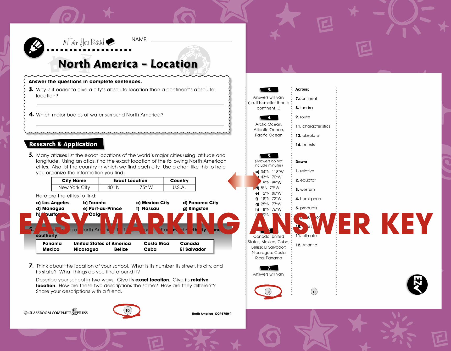
3. Why is it easier to give a city’s absolute location than a continent’s absolute location?
4. Which major bodies of water surround North America?
5. Many atlases list the exact locations of the world’s major cities using latitude and longitude. Using an atlas, find the exact location of the following North American cities. Also list the country in which we find each city. Use a chart like this to help you organize the information you find.
Here are the cities to find:
a) Los Angeles b) Toronto c) Mexico City d) Panama City d) Managua e) Port-au-Prince f) Nassau g) Kingston h) Houston i) Calgary
City Name Exact Location Country New York City 40° N 75° W U.S.A.
6. Using your map of North America, list these countries from most northerly to most southerly.
Panama United States of America Costa Rica Canada Mexico Nicaragua Belize Cuba El Salvador
7. Think about the location of your school. What is its number, its street, its city, and its state? What things do you find around it?
Describe your school in two ways. Give its exact location. Give its relative location. How are these two descriptions the same? How are they different? Share your descriptions with a friend.
PREA
SSES
SMEN
T
CO
MPR
EHEN
SIO
N
QUE
STIO
NS
READ
ING
PAS
SAG
E
SHO
RT A
NSW
ER
QUE
STIO
NS
NAME:
...................After You Read
North America CCP5750-111
Crossword Puzzle!
Across7. North America is the third largest
_____ in the world8. A region in the most northerly parts
of Alaska and Canada9. A path taken from one place to
another11. A place can be described by
physical and human _____13. _____ location descibes exactly
where a place is14. many people live along the ____
because they need water for transportation
6
13
7
1
2
6
9
11 12
4 5
7
8
13
3
10
14
Down1. North America is best described by
its _____ location2. North America is north of this
imaginary line 3. North America is found in the _____
hemisphere4. One of the shapes made by cutting
a sphere in half5. Things people use at home, work
and school6. The ____ in North America is growing10. The Mississippi is one of North
America’s great _____11. The temperature, rain and/or
snowfall found in a place12. The ____ Ocean lies to the east of
North America
Word ListtundrapopulationcharacteristicshemispherecontinentrelativecoastsriversrouteproductsabsoluteequatorAtlanticwesternclimate
NAME:
...................After You Read
North America CCP5750-113
Comprehension Quiz30
SUBTOTAL: /14
8
Label the map by doing the following:
1. Show the following features on the map by writing the letter on the map in the correct location. a) North America b) Atlantic Ocean c) Pacific Ocean d) Arctic Ocean e) South America
2. Color the Equator red.
6
Part A
Part B
T FT F
T FT F
a) North America is in the eastern hemisphere.
b) Lines of latitude are used to find the location of a place north or south of the Equator.
c) The plants that grow in a place are called vegetation.
d) The Great Plains is a cold and mountainous region.
e) The Equator is an imaginary line that runs from the North Pole to the South Pole.
f) A rainforest has a dry, dusty climate.
g) Latitude and longitude are used to find a place’s absolute location.
h) Oceans provide links between the continents.
T FT F
T F
T F
Circle if the statement is true or if it is false. T = TrueF = False
T F
NAME:
...................After You Read
North America CCP5750-112
Word Search
hemispherelocation
populationcommunication
featuretundra
link
netahttmelicamnnasycersoenaoddthgeghctwe
hrelaanchoyooetremobdutigerecretsernoita
lnoittlrlniocc mo
m oal
b apn
na
g
ornea
luoi
o
r a
sd
e
mi
m
e
i
a
f
ol
i
c
to
uu
el
a
u
i
i
yai
m
v
os
nl
nn
ttfqaagfeh
rx
a
gntn
ouu
iaditsu
w
rmtsbemhee
euoprdumsescoihcivmarteusdcieee
e
eegaratvuttoseluparnrhrenetnhc
lldrpstcudetamioit
fnoitcaret
atvdhigiehup
virtdn
ufe
ne
me
tag
popgg
iv
co
hu
lu
niraenhlsacorplceegehwande
nnuitlrnantknrevlubmywoenrwbto
rnblosoiugtp
balursallinyeovlrpsn
Find all of the words in the Word Search. Words may be horizontal, vertical, or diagonal. A few may even be backwards! Look carefully!
countrycoast
latitudeEquator
environmentriver
movement
productslanguagerainforestabsolutelongitudeclimate
interaction
continenthighwayregion
vegetationrelative
characteristic
CRO
SSW
ORD
ASSE
SSM
ENT
WO
RD S
EARC
H
CO
LOR
POST
ERS
EZ
No
rth Am
eric
a C
CP
5750-1 8 9 10
1.
2.
7
1
2
3
4
5
C
A
D
B
E
western hemisphere, north of the equator,
etc.
a)
b)
c)
d)
e)
f)
g)
h)
FF FT
T
T
FT
a) location
b) two
c) relative
d) absolute
e) latitude
f) longitude
g) continent
h) hemisphere
i) Equator
j) climate
1.
2.
Answers will vary (i.e. It is smaller than a
continent…)
Arctic Ocean,Atlantic Ocean,Pacific Ocean
(Answers do not include minutes)
a) 34°N 118°Wb) 43°N 70°Wc) 19°N 99°Wd) 8°N 79°We) 12°N 86°Wf) 18°N 72°Wg) 25°N 77°Wh) 18°N 76°Wi) 29°N 95°W
Canada; United States; Mexico; Cuba;
Belize; El Salvador; Nicaragua; Costa
Rica; Panama
Answers will vary
3.
4.
5.
6.
7.
Latitude are the horizontal grid lines, Longitude are the vertical grid lines.
11
Across:
7.continent
8. tundra
9. route
11. characteristics
13. absolute
14. coasts
Down:
1. relative
2. equator
3. western
4. hemisphere
5. products
6. population
10. rivers
11. climate
12. Atlantic
NAME:
...................After You Read
North America CCP5750-110
Answer the questions in complete sentences.
Research & Application
North America – Location
3. Why is it easier to give a city’s absolute location than a continent’s absolute location?
4. Which major bodies of water surround North America?
5. Many atlases list the exact locations of the world’s major cities using latitude and longitude. Using an atlas, find the exact location of the following North American cities. Also list the country in which we find each city. Use a chart like this to help you organize the information you find.
Here are the cities to find:
a) Los Angeles b) Toronto c) Mexico City d) Panama City d) Managua e) Port-au-Prince f) Nassau g) Kingston h) Houston i) Calgary
City Name Exact Location Country New York City 40° N 75° W U.S.A.
6. Using your map of North America, list these countries from most northerly to most southerly.
Panama United States of America Costa Rica Canada Mexico Nicaragua Belize Cuba El Salvador
7. Think about the location of your school. What is its number, its street, its city, and its state? What things do you find around it?
Describe your school in two ways. Give its exact location. Give its relative location. How are these two descriptions the same? How are they different? Share your descriptions with a friend.
EASY MARKING ANSWER KEY