Embed Size (px)
Citation preview

Episodes, Vol. 37, no. 4
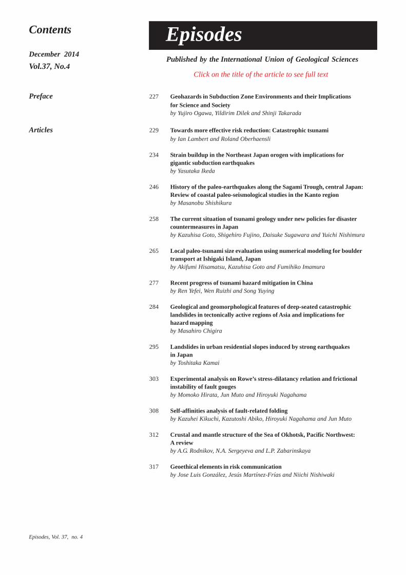
225Contents
December 2014
Vol.37, No.4
Preface 227 Geohazards in Subduction Zone Environments and their Implicationsfor Science and Societyby Yujiro Ogawa, Yildirim Dilek and Shinji Takarada
Articles 229 Towards more effective risk reduction: Catastrophic tsunamiby Ian Lambert and Roland Oberhaensli
234 Strain buildup in the Nor theast Japan orogen with implications forgigantic subduction earthquakesby Yasutaka Ikeda
246 History of the paleo-earthquakes along the Sagami Tr ough, central Japan:Review of coastal paleo-seismological studies in the Kanto regionby Masanobu Shishikura
258 The current situation of tsunami geology under new policies for disastercountermeasures in Japanby Kazuhisa Goto, Shigehiro Fujino, Daisuke Sugawara and Yuichi Nishimura
265 Local paleo-tsunami size evaluation using numerical modeling for bouldertransport at Ishigaki Island, Japanby Akifumi Hisamatsu, Kazuhisa Goto and Fumihiko Imamura
277 Recent progress of tsunami hazard mitigation in Chinaby Ren Yefei, Wen Ruizhi and Song Yuying
284 Geological and geomorphological features of deep-seated catastrophiclandslides in tectonically active regions of Asia and implications forhazard mappingby Masahiro Chigira
295 Landslides in urban residential slopes induced by strong earthquakesin Japanby Toshitaka Kamai
303 Experimental analysis on Rowe’s stress-dilatancy relation and frictionalinstability of fault gougesby Momoko Hirata, Jun Muto and Hiroyuki Nagahama
308 Self-affinities analysis of fault-related foldingby Kazuhei Kikuchi, Kazutoshi Abiko, Hiroyuki Nagahama and Jun Muto
312 Crustal and mantle structure of the Sea of Okhotsk, Pacific Northwest:A reviewby A.G. Rodnikov, N.A. Sergeyeva and L.P. Zabarinskaya
317 Geoethical elements in risk communicationby Jose Luis González, Jesús Martínez-Frías and Niichi Nishiwaki
Published by the International Union of Geological Sciences
Episodes
Click on the title of the article to see full text
December 2014
Contents
December 2014
Vol.37, No.4
321 Global earthquake and volcanic eruption risk management activities,volcanic hazard assessment support system and Asia-Pacific regionhazard mapping project in G-EVERby Shinji Takarada, Joel C. Bandibas, Yuzo Ishikawa andG-EVER Promotion Team
329 Report of the 2nd G-EVER International Symposium and the 1st IUGSand SCJ International Workshop on Natural Hazards and the“Sendai Agreement”by Eikichi Tsukuda and G-EVER Promotion Team
Conference Report 332 Pursuing the evolution of the Asian Tethyan realm – Third InternationalSymposium of IGCP-589
Obituary 333 David Oldroyd (1936-2014)
334 Calendar
335 Index
Cover
Front: Largest Porites coral boulder in eastern Ishigaki Island, Okinawa, Japan, which wastransported and deposited by the 1771 Meiwa tsunami based on the sedimentologicalobservationand radiocarbon dating. This was designated as a national monument inJapan in 2013. Refer to the paper of Goto et al. in this issue. (Photo taken by KazuhisaGoto)
Back: Northern view of Ontake Volcano summit area, where thickly covered by grey phreaticash and ballistics. (Photo courtesy: Shun Nakano, GSJ, AIST on Sep.28, 2014).Phreatic eruption occurred at the southern part (upstream area of Jigokudani Valley;white plume area) of Ontake Volcano, central Japan at 11:52 on Sep. 27, 2014. Thephreatic eruptions were continued for more than one hour and associated pyroclasticsurges were observed. Thick accumulation of phreatic ash (up to 30 cm -1m in thickness)and a lot of ballistics (a few cm to m size) were observed at the summit area. The totaldischarged mass was about 1 million ton. This is the almost same discharged mass ofthe previous 1979 eruption. More than 500 climbers and hikers were on the summitarea at the time of eruption, because it was noon of Saturday weekend. Totally 57people, who were within about 1 km from the vent area, were killed mainly by theimpact of ballistics. Six people are still missing (as of Nov 14. 2014). 69 people wereinjured. The number of victims is the worst volcanic disaster in Japan after the WorldWar II. The front crater with a small pond is Ninoike and central crater is Ichinoike.The summit of Ontake Volcano, Kengamine (3,067 m a.s.l.), is seen at the left side ofIchinoike, where many people were dead and injured. (Shinji Takarada, GSJ, AIST)
Episodes
Episodes Vol. 37, no. 4
277
by Ren Yefei, Wen Ruizhi and Song Yuying
Recent progress of tsunami hazard mitigation inChinaInstitute of Engineering Mechanics, China Earthquake Administration, Harbin 150080, China. E-mail: [email protected]
the statistical analysis shows that 25% of the Chinese GDP is producedalong the coastal areas at elevations below 5 meters (Chen et al.,2007).
The lessons from the 2004 Sumatra Tsunami and 2011 TohokuTsunami have increased the awareness of tsunami risks in China. Inthis paper, we briefly review the recent progress of tsunami hazardmitigation in the Chinese mainland, not including Taiwan and HongKong. This study focuses on a Chinese historical tsunami eventcatalogue, a numerical tsunami model, and tsunami early warningsystem as well as the tsunami hazard analysis methodology.
Chinese tsunami research before 2004China is located at the eastern edge of Asia adjacent to the
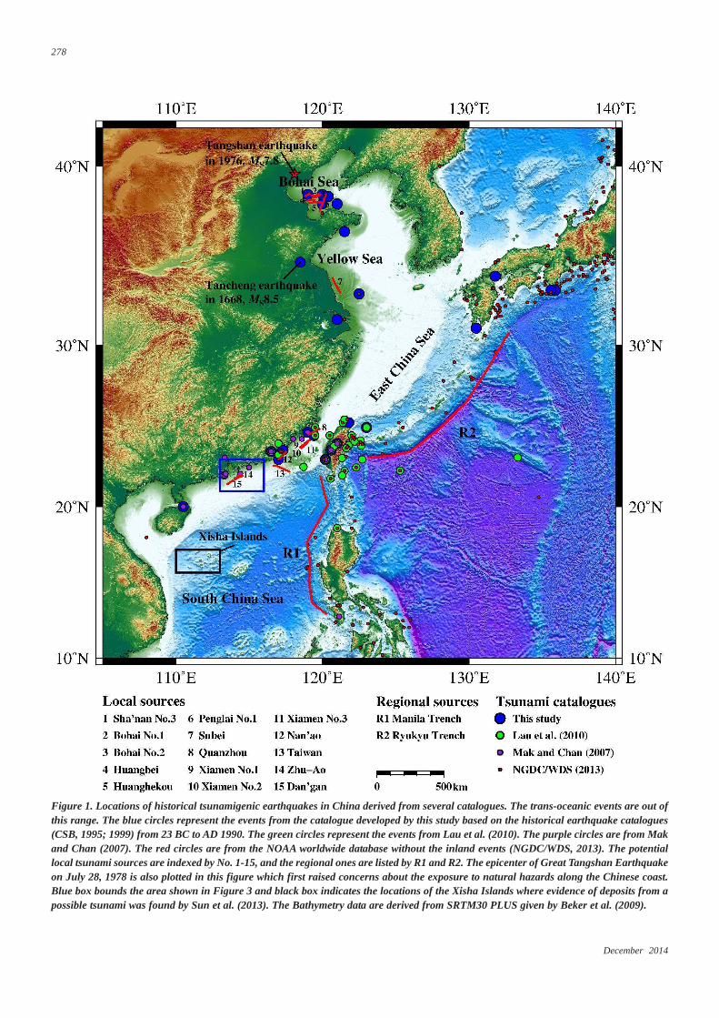
northwestern segment of the circum-Pacific earthquake belt. Fromnorth to south, the seas bordering China are the Bohai Sea, the YellowSea, the East China Sea and the South China Sea. In the Bohai andYellow Seas, the average depth is 18 m and 44 m, with a maximumdepth of only 100 m. However, in the East China Sea and the SouthChina Sea, the average depth is 340 m and 1200 m, respectively, asshown in Figure 1.
The Great Tangshan Earthquake (epicenter is shown in Figure 1)on July 28, 1978, raised concerns about the exposure to natural hazardsalong the Chinese coast. In 1982, it was commonly suggested thatthe Chinese coast would be little affected by a tsunami (Li, 1982),and this advice was regarded by the China Seismological Bureau(CSB), which is now the China Earthquake Administration (CEA).In fact, from 1904 to 1968 approximately 350 earthquakes withmagnitudes greater than 7.0 occurred in the northwest Pacific Ocean;33 of these earthquakes, approximately 10% of the total number,occurred off the Chinese coast, but only two of them generatedtsunamis with low wave amplitudes (Zhou and Adams, 1986; 1988;Wang et al., 2005).
In 1986, a book named Earthquake Countermeasure waspublished. One of the chapters of this book reconsiders the tsunamidisaster countermeasures that should be used in China (Guo, 1986).In the same year, Zhou and Adams (1986) investigated the historicalevents of Chinese tsunamigenic earthquakes and suggested that thehistorical data could provide a basis for the development of Chinesetsunami hazard zonation maps considering the geological andgeophysical characteristics of three prominent seismic zones forChina.
Zhou and Adams (1986) paper could be the first in which Chineseresearchers showed their opinions in an international journal. Later,a preliminary tsunami risk analysis was performed for the coast ofChina, stating that the ratio of risk among the East Taiwan Coast,Continental Shelf and Bohai Sea was approximately 16:4:1, and the
Since the disastrous aftermath of the 2004 SumatraTsunami (Indonesia) and the 2011 Tohoku Tsunami(Japan), China has made much effort to mitigate tsunamihazards. We briefly reviewed the progress of cataloguing,modeling, early warning and hazard analysis fortsunamis in China. Compiling a Chinese tsunamicatalogue is a challenge at present due to a largenumber of inconsistent research results. In China, thenumerical models widely used in engineering and relatedstudies are developed by other countries, and thedevelopment of a domestic model is being funded by theChinese government. The tsunami early warning systemhas been set up and used during the recent tsunamievents, such as the Chile earthquake on February 27,2010, and the Tohoku earthquake on March 11, 2011.Probabilistic tsunami hazard analysis (PTHA) in Chinahas been used for the national zonation map. A test caseof PTHA at Mirs Bay of South China was demonstrated.The test case supported the general view that a regionaltsunami could be a great hazard to the south Chinacoast.
Introduction
Recently, many large infrastructures have emerged along theChinese coast, necessitating a rigorous tsunami risk assessment,because the Chinese coast cannot be immune to tsunami hazards.Therefore, China began to keep track of the potential tsunami hazardsemanating from the Pacific Ocean after the 2004 Sumatra Tsunami.On March 11, 2011, the Japanese Tohoku Earthquake triggered adestructive tsunami that swept over cities and farmlands along thenorthern part of Japan and threatened coastal areas throughout thePacific. This event led to a reconsideration of the safety of coastalnuclear power plant (NPP) sites and other infrastructures. There are13 NPP sites along the coast of the Chinese mainland at present, with15 nuclear units in operation and 26 units under construction (Changet al., 2013). After the Japanese Fukushima NPP accident in 2011,which was caused by an earthquake and tsunami, Chinese NPP safetyfrom extreme external events, including events beyond the designbasis, such as tsunamis, was reevaluated. In addition, the coastal areais the most economically developed zone in China. Based on 1:100m digital elevation models (DEM) and national GDP data in 2004,
December 2014
278
Figure 1. Locations of historical tsunamigenic earthquakes in China derived from several catalogues. The trans-oceanic events are out ofthis range. The blue circles represent the events from the catalogue developed by this study based on the historical earthquake catalogues(CSB, 1995; 1999) from 23 BC to AD 1990. The green circles represent the events from Lau et al. (2010). The purple circles are from Makand Chan (2007). The red circles are from the NOAA worldwide database without the inland events (NGDC/WDS, 2013). The potentiallocal tsunami sources are indexed by No. 1-15, and the regional ones are listed by R1 and R2. The epicenter of Great Tangshan Earthquakeon July 28, 1978 is also plotted in this figure which first raised concerns about the exposure to natural hazards along the Chinese coast.Blue box bounds the area shown in Figure 3 and black box indicates the locations of the Xisha Islands where evidence of deposits from apossible tsunami was found by Sun et al. (2013). The Bathymetry data are derived from SRTM30 PLUS given by Beker et al. (2009).
Episodes Vol. 37, no. 4
279
tsunami hazard zonation of China with three levels was then suggested(Zhou and Adams, 1988). At the end of 1990, the State OceanicAdministration of China (SOA) launched a research program forcollecting historical tsunami data, developing teletsunami and localtsunami propagation models. Both models were then applied to thetsunami hazard assessment in five early NPP sites: Dayawan, Qinshan,Sanmen, Lianyungang and Hui’an (Yu et al., 2001).
The knowledge of tsunami hazards at that time was not completelyrecognized, and the research was only limited to meet the constructionof certain NPP sites. Most of the opinions at that time stated thatthere was an extremely low probability of the recurrence frequencyfor tsunamigenic earthquakes near the Chinese coast. On December26, 2004, the tsunami event in the Indian Ocean became known tothe public, leading to a new round of tsunami research and hazardmitigation in China.
Chinese tsunami catalogueHistorical tsunami catalogues have been compiled for many
regions in the world, highlighting the occurrence and geographicalextent of several large tsunamis. These catalogues may also supportan elementary statistical analysis of the recurrence intervals of tsunamisof different magnitudes. Throughout Chinese history overapproximately the past 3,000 years, tsunami events and runup datacould be found in the literature. To identify a tsunami event, a catalogueneeds to collect the information on the location, date and time, eventmagnitude, maximum water height, total number of deaths andinjuries, and total damage. However, many written records seem tobe inconsistent and fragmented. As a result, different studies developedtsunami catalogues based on the different data sources and obtaineddifferent results. Lu (1984) compiled the historical documents withdescriptions of marine disasters, including approximately 227 possibletsunami events, covering the years from 47 BC to AD 1978. However,Chau (2008) believed that this catalogue had been overlooked orignored by previous authors, and the total number of tsunamiassociated with definite earthquake events was only four, the numberof tsunami induced by meteorological impact was only one, and theremaining 222 events were of unknown origin. Mak and Chan (2007)documented the historical tsunamis of South China, and only twoevents had been identified as credible reports of tsunamis, and certainevents that were previously considered as tsunamis, including a fewwith many reported casualties, were found to be unsubstantial. Basedon 15 previously published regional databases incorporating morethan 100 sources for the northeastern region of the South China Sea,Lau et al. (2010) built a database identifying 58 recorded tsunamievents between AD 1076 and 2009.
These two catalogues focused on the South China Sea. In thepresent study, we attempt to develop a tsunami catalogue characteri-zing the whole Chinese coast. As we know, tsunamis are mainlytriggered by large earthquakes, and a simple way to find the historicaltsunami events is to search statements about the inundationphenomenon in currently recognized earthquake catalogues. We tooka closer look into the Chinese Historical Strong Earthquake Cataloguefrom 23 BC to AD 1911 and the Chinese Modern EarthquakeCatalogue from 1912 to 1990 (CSB, 1995; 1999). We have indentified25 events as the tsunamigenic earthquakes during approximately thepast 2000 years along the Chinese coast, as shown in Figure 1.However, some of the events are still arguable, such as the Tanchengearthquake in 1668, which had an epicenter located inland (Figure
1), but some studies stated that this giant earthquake caused a tsunamithat affected the Korean Peninsula (Li et al, 2003). Note that fourevents generated in Japan also affected the Chinese coast. These arethe Meio Earthquake in 1498, Hoei Earthquake in 1707, Ansei-NankaiEarthquake in 1854, and Ryukyu Earthquake in 1923. Many Chinesehistorical documents recorded the phenomena of rising tide at differentlocations for each event. However, the flood and inundation associatedwith injuries and deaths were recorded only in the Ansei-NankaiEarthquake. In general, tsunamis generated in Japan have little effecton the Chinese coast.
Figure 1 shows the event locations of the three above mentionedcatalogues. The events from the NOAA tsunami database, which is alist of historical tsunami events and runup locations throughout theworld that range in date from 2000 BC to the present, are also shownin Figure 1 (NGDC/WDS, 2013). Until now, there has been noevaluation of the different tsunami catalogues in China. Figure 1clearly shows that there is still not a consistent list of events along theChinese coast due to the different literature and identification rules.The compilation of a Chinese tsunami catalogue is still a greatchallenge.
Furthermore, paleo-tsunami research, which is the investigationof geological deposits, is another way to identify past tsunami events.For a major tsunami that causes extensive inundation and reachesmultiple kilometers inland, a unique geological deposit would beproduced. The identification of paleo-tsunami deposits in China wasperformed in recent years. Shi et al. (2012) surveyed 55 coastal siteson the Chinese coast to look for evidence of tsunami-generatedgeological deposits. Unfortunately, no visual evidence was found.Considering the tectonic setting, the study concluded that “the sea-overflow” described in Chinese ancient books could be not consideredas tsunami events (Shi et al., 2012). However, Sun et al. (2013) recentlyreported preliminary research results from the Xisha Islands (locationis shown in Figure 1) in the South China Sea, investigating a largetsunami that may have occurred around AD 1024. Sand layers in lakesediment cores and the geochemical characteristics indicate a suddendeposition event around AD 1024, which is temporally consistentwith the written record of a disastrous event, characterized by highwaves in AD 1076. This study presents evidence of deposits from apossible tsunami in this area and calls for awareness of the potentialrisk of tsunamis in the South China Sea.
Paleo-tsunami information could help to expand the time span ofthe tsunami catalogue. Studies on historical documents and tsunamideposits are the two key ways to understand much more about themagnitude and return period of great events in the past. Results fromthese two topics will help to improve the later studies such as PTHA.Therefore, we suggest a complete tsunami catalogue should beauthoritatively published, and many more field surveys on theidentification of tsunami geological deposits should be performedalong the whole Chinese coast.
Tsunami modeling and its applicationThe National Marine Environmental Forecasting Center
(NMEFC) of SOA is an early institution in China to develop numericalmodels for simulating the process of tsunami generation andpropagation in the 1980s with reference to the TUNAMI (TohokuUniversity’s Numerical Analysis Model for Investigation of near andfar field tsunamis) code (Yu et al., 2001; Imamura et al., 1988). TheChinese Tsunami Model (CTM) was established and has run since
December 2014
280
2005, just after the 2004 Sumatra Tsunami. For this model, thegeometrical displacement of the seafloor is assumed to be the sameas the initial tsunami wave field, and the formula of fault dislocationin elastic anisotropic half-space is deployed (Mansinha and Smylie,1971). The finite difference method is used to solve linear and non-linear shallow-water equations, and the leap-frog scheme is used toimprove the model’s high-speed computation. After 2009, this modelwas updated to a parallel version based on the OPENMP (Open Multi-Processing) system and was used to estimate the probable maximumtsunami waves for several NPP sites. Recently, several researchersfrom universities and institutions have become interested in studieson tsunami simulation that emphasize the fundamental physical theory(Zhu et al., 2006).
Most engineers and scientists in the Chinese mainland prefer touse popular international models for engineering applications andscientific studies related to tsunami hazards. For instance, Pan et al.(2009) used the COMCOT (Cornell Multi-grid Coupled TsunamiModel) to simulate scenario tsunamis in the South China Sea andshowed that there would be an approximate 0.3-0.5 m tsunami waveheight along the coastline where the water depth is 20 m in the caseof an M8.0 earthquake, and above 3 m in the case of an M9.0earthquake. Wen et al. (2008) also used the COMCOT to simulatethe tsunami propagation generated by a scenario M8.5 earthquakenear the Okinawa Trough and showed that the maximum initialtsunami wave height was estimated to be 4.3 m. It would takeapproximately 4 hours for a tsunami wave to propagate from the sourceto the coast of Zhejiang Province in this case, with a maximum heightof approximately 2.0 m, and 8 hours to reach to the shoreline ofShanghai. Using the TUNAMI-N2-NUS model, Dao et al. (2008)studied various tsunami scenarios in the South China Sea, and themaximum tsunami wave height reached 8 m in the coastal area ofGuangdong Province for the worst-case scenario. Yu et al. (2011a)used the GeoClaw model to simulate the propagation process andcharacteristics of the 2010 Chile Tsunami around China coastal areasand quantitatively analyzed the impact of this tsunami on Chinesecoast.
In general, engineers and scientists in China apply commonlyused numerical tsunami models to accomplish their engineering orresearch tasks. However, we hope a domestic model will be developedin the future supported by more funds from the Chinese government.
Chinese tsunami early warning systemIn 1994, when tsunami waves were observed by tide gauges
around Hainan Island in China, the development of a Chinese tsunamiwarning service system was proposed (Ye et al., 1994). After the 2004Sumatra earthquake, Wen et al. (2006) suggested the integration ofthe Chinese seismic monitoring network and the tsunami simulationmodel to build the tsunami early warning system in China. Liu et al.(2009) proposed a procedure to establish a tsunami early warningsystem for the South China Sea region focusing on the characteristicsof tsunamis generated from earthquakes along the Manila subductionzone. In 2010, the Regional South China Tsunami System (RSCTS)was established by the Earthquake Administration of GuangdongProvince, which is in charge of backing up the data of the Chineseseismic monitoring network. The seismic monitoring data can be easilyintegrated into RSCTS, and this system is mainly responsible fortsunami warning for the coast of the Guangdong and Hainan Provinces(Chen and Ye, 2010).
The China Tsunami Early Warning Center (CTEWC) wasestablished in 2013 and is the only national agency responsible forproducing and issuing tsunami warnings. Based on the earthquakeinformation provided by the Chinese Earthquake Networks Centre(CENC) and the tsunami information provided by the Pacific TsunamiWarning Center (PTWC), CTEWC has the ability to evaluate themaximum wave height in the Chinese coastal area using a CTM modeland to release tsunami warning information to the public in 20 minutesafter the earthquake occurs. CTEWC releases the tsunami earlywarning to their local agencies first; then the agencies release it tolocal people who may be affected by the coming tsunami waves.Meanwhile, the warning information would be pasted on theCTEWC’s webpage where anyone can access it. The Chinese TsunamiTravel Time Model (CTTTM) can also provide an estimation of thewave arrival time after a tsunami event. This model was implementedin 2005 by CTEWC, covering the entire Chinese sea with the2´ resolution bathymetry data.
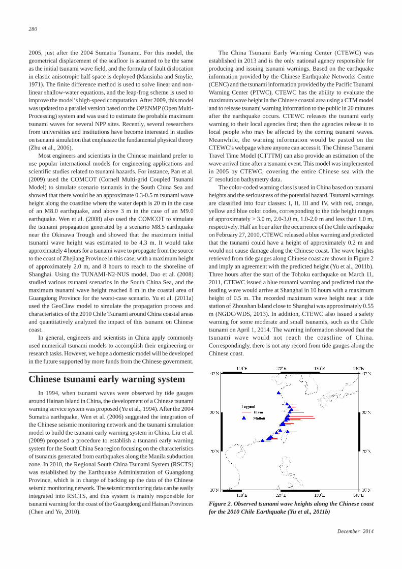
The color-coded warning class is used in China based on tsunamiheights and the seriousness of the potential hazard. Tsunami warningsare classified into four classes: I, II, III and IV, with red, orange,yellow and blue color codes, corresponding to the tide height rangesof approximately > 3.0 m, 2.0-3.0 m, 1.0-2.0 m and less than 1.0 m,respectively. Half an hour after the occurrence of the Chile earthquakeon February 27, 2010, CTEWC released a blue warning and predictedthat the tsunami could have a height of approximately 0.2 m andwould not cause damage along the Chinese coast. The wave heightsretrieved from tide gauges along Chinese coast are shown in Figure 2and imply an agreement with the predicted height (Yu et al., 2011b).Three hours after the start of the Tohoku earthquake on March 11,2011, CTEWC issued a blue tsunami warning and predicted that theleading wave would arrive at Shanghai in 10 hours with a maximumheight of 0.5 m. The recorded maximum wave height near a tidestation of Zhoushan Island close to Shanghai was approximately 0.55m (NGDC/WDS, 2013). In addition, CTEWC also issued a safetywarning for some moderate and small tsunamis, such as the Chiletsunami on April 1, 2014. The warning information showed that thetsunami wave would not reach the coastline of China.Correspondingly, there is not any record from tide gauges along theChinese coast.
Figure 2. Observed tsunami wave heights along the Chinese coastfor the 2010 Chile Earthquake (Yu et al., 2011b)
Episodes Vol. 37, no. 4
281
CTEWC, which is now attached to NMEFC, is collaborating withthe U.S. Pacific Marine Environmental Laboratory (PMEL) to builda real-time tsunami forecasting system in the South China Sea. Tomonitor potential tsunami waves generated by a submarine earthquakein the Manila Trench and to provide early warning for the southernChina coast, SOA deployed two buoys in the South China Sea thatcan monitor tsunami waves within 15-30 min if the tsunami isgenerated by an earthquake in the Manila Trench, and the real-timebuoy data could also be accessed (Zhao et al., 2013).
The Chinese seismic monitoring network consists of manyseismic stations, and SOA manages more than 100 marine gauges,most of which collect and transmit real-time data. Recent advancednumerical modeling technologies are being integrated with bothearthquake and tsunami monitoring networks to create a more effectivetsunami early warning system. Automatic collection of earthquakeinformation data could be processed. We believe that the tsunamiwarning bulletin could also be automatically generated in the futurebased on predefined templates.
Probabilistic Tsunami Hazard Analysis (PTHA)in China and a test case
Deterministic Tsunami Hazard Analysis (DTHA) is a simple wayto qualitatively assess the tsunami hazard for a site of interest and hasbeen widely used in China (e.g., Zhou and Adams, 1988; Yang andWei, 2005; Wen et al., 2008; Ren et al., 2010). However, the preferredmethod for evaluating the tsunami hazard in China is starting to shiftfrom DTHA to Probabilistic Tsunami Hazard Analysis (PTHA). Liuet al. (2007) performed a PTHA for the southern China coast affectedby the potential sources in the Manila Trench. The results show thatthe probability that a tsunami wave with a height over 2.0 m will hit
coastal areas in Hong Kong and Macau is approximately 10%, andthe cities in Taiwan are less vulnerable than those on the mainlandcoast. The authors of this paper are devoted to pushing the PTHAforward in China under the funding supported by the National NaturalScience Foundation of China (NSFC). We have proposed a ChinesePTHA method by following the regular seismic hazard analysismethods in China and gave a detailed description of the framework(Wen et al., 2011).
PTHA is derived from Probabilistic Seismic Hazard Analysis(PSHA). If we assume a Poisson time process, the probability that atsunami with amplitude H greater than a given height h (i.e., H ≥ h)occurs per year at a coastal site is given by the function:
1
( ) 1 (1 ( ))N
nn
P H h P H h=
≥ = − − ≥∏ (1)
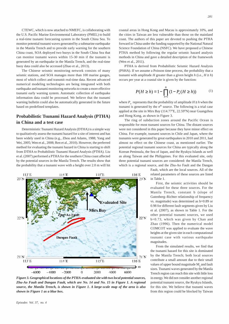
where Pn represents that the probability of amplitude H ≥ h when thetsunami is generated by the nth source. The following is a trial caseapplied at the site in Mirs Bay (114.77oE, 22.59oN) near Guangzhouand Hong Kong, as shown in Figure 3.
The ring of subduction zones around the Pacific Ocean isresponsible for most tsunami sources for China. The distant sourceswere not considered in this paper because they have minor effect onChina. For example, tsunami sources in Chile and Japan, where thetsunamis were generated by great earthquakes in 2010 and 2011, hadalmost no effect on the Chinese coast, as mentioned earlier. Thepotential regional tsunami sources for China are typically along theKorean Peninsula, the Sea of Japan, and the Ryukyu Islands as wellas along Taiwan and the Philippines. For this evaluated site, onlythree potential tsunami sources are considered: the Manila Trench,which is a regional source, and the Zhu-Ao Fault and the Dangan
Figure 3. Geographical locations of the PTHA-evaluated site with two local potential sources,Zhu-Ao Fault and Dangan Fault, which are No. 14 and No. 15 in Figure 1. A regionalsource, the Manila Trench, is shown in Figure 1. A large-scale map of the area is alsoshown in Figure 1 as a blue box.
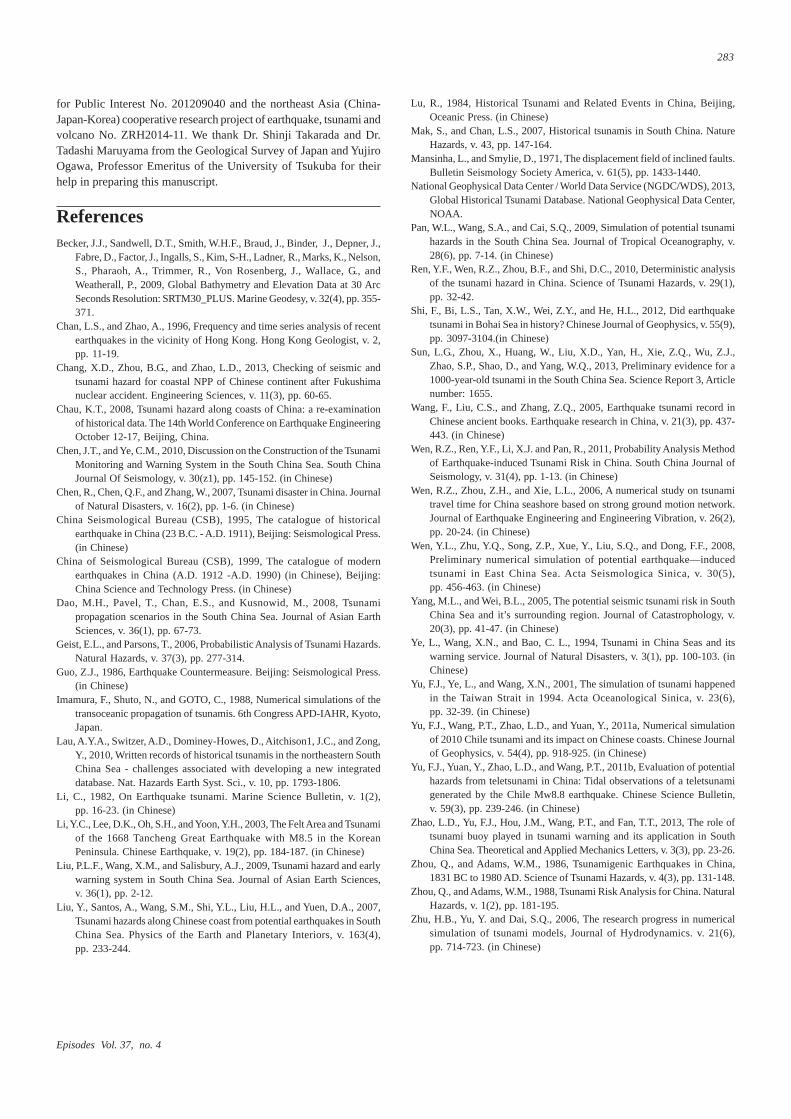
Fault, which are the local sources. All of therelated parameters of these sources are listedin Table 1.
First, the seismic activities should beevaluated for these three sources. For theManila Trench, constant b (slope ofGutenberg–Richter relationship of frequencyvs. magnitude) was determined as b=0.89 or0.98 for different fault segments given by Liuet al. (2007), as shown in Table 1. For theother potential tsunami sources, we usedb=0.73, which was given by Chan andZhao (1996). Then the numerical modelCOMCOT was applied to evaluate the waveheights at the given site in each computationaltsunami case with various earthquakemagnitudes.
From the simulated results, we find thatthe tsunami hazard for this site is dominatedby the Manila Trench; both local sourcescontribute a small amount due to their smallvalues of upper bound magnitude Mu and faultsizes. Tsunami waves generated by the ManilaTrench region can reach this site with little lossin energy. We did not consider another regionalpotential tsunami source, the Ryukyu Islands,for this site. We believe that tsunami wavesfrom this region could be blocked by Taiwan
December 2014
282
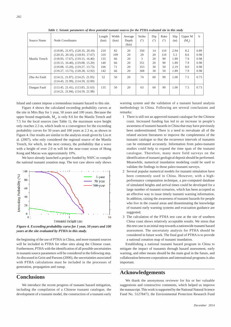
Island and cannot impose a tremendous tsunami hazard to this site.Figure 4 shows the calculated exceeding probability curves at
the site in Mirs Bay for 1 year, 50 years and 100 years. Because theupper bound magnitude, Mu, is only 8.6 for the Manila Trench and7.5 for the local sources (see Table 1), the maximum wave heightonly reaches 2.3 m, which leads to a convergence for the exceedingprobability curves for 50 years and 100 years at 2.3 m, as shown inFigure 4. Our results are similar to the analysis result given by Liu etal. (2007), who only considered the regional source of the ManilaTrench, for which, in the next century, the probability that a wavewith a height of over 2.0 m will hit the near-coast ocean of HongKong and Macau was approximately 10%.
We have already launched a project funded by NSFC to compilethe national tsunami zonation map. The test case above only shows
warning system and the validation of a tsunami hazard analysismethodology in China. Following are several conclusions andremarks:
1 There is still not an approved tsunami catalogue for the Chinesecoast. Increased funding has led to an increase in people’sawareness of tsunami hazards in China that may have previouslybeen underestimated. There is a need to reevaluate all of therelated ancient literatures to improve the completeness of thetsunami catalogue so that the recurrence intervals of tsunamiscan be estimated accurately. Information from paleo-tsunamistudies could help to expand the time span of the tsunamicatalogue. Therefore, many more field surveys on theidentification of tsunami geological deposit should be performed.Meanwhile, numerical inundation modeling could be used tovalidate the findings in those paleo-tsunami surveys.
2 Several popular numerical models for tsunami simulation havebeen commonly used in China. However, with a high-performance computation technique, a pre-computed databaseof simulated heights and arrival times could be developed for alarge number of tsunami scenarios, which has been accepted asan effective way to issue timely tsunami warning information.In addition, raising the awareness of tsunami hazards for peoplewho live in the coastal areas and disseminating the knowledgeof tsunami early warning systems and evacuation guidance aresuggested.
3 The calculation of the PTHA test case at the site of southernChina coast shows relatively acceptable results. We stress thatthis test case is an initial step towards a nationwide tsunami hazardassessment. The uncertainty analysis for PTHA should beconsidered in future work. The final goal of PTHA is to providea national zonation map of tsunami inundation.
Establishing a national tsunami hazard program in China tomitigate the impact of tsunamis through hazard assessment, earlywarning, and other means should be the main goal in the future, andcollaboration between corporations and international programs is alsoimportant.
AcknowledgementsWe thank the anonymous reviewer for his or her valuable
suggestions and constructive comments, which helped us improvethe manuscript. This work is supported by the National Natural ScienceFund No. 51278473, the Environmental Protection Research Fund
Table 1. Seismic parameters of three potential tsunami sources for the PTHA evaluated site in this study
Length Width Average Strike Dip Rake Slip Upper M bSource Name Node Coordinates (km) (km) Depth (°) (°) (°) (m) (Mu)
(km)
(119.85, 21.97), (120.35, 20.10) 210 82 20 350 14 110 2.94 8.2 0.89(120.35, 20.10), (118.93, 17.67) 310 109 20 29 20 110 5.3 8.6 0.98
Manila Trench (118.93, 17.67), (119.15, 16.40) 135 66 20 3 20 90 1.89 7.9 0.98(119.15, 16.40), (119.08, 15.20) 140 66 20 351 20 90 1.89 7.9 0.98(119.08, 15.20), (119.27, 13.73) 166 71 20 353 30 50 2.19 8.0 0.98(119.27, 13.73), (120.28, 12.92) 142 66 20 308 30 50 1.89 7.9 0.98
Zhu-Ao Fault (114.11, 21.87), (114.25, 21.95) 52 50 20 74 60 90 1.00 7.5 0.73(114.43, 21.99), (114.59, 22.00)
Dangan Fault (113.45, 21.41), (113.83, 21.63) 135 50 20 63 60 90 1.00 7.5 0.73(114.21, 21.84), (114.59, 21.98)
Figure 4. Exceeding probability curve for 1 year, 50 years and 100years at the site evaluated by PTHA in this study.
the beginning of the use of PTHA in China, and more tsunami sourceswill be included in PTHA for other sites along the Chinese coast.Furthermore, PTHA with the identification of all possible uncertaintiesin tsunami source parameters will be considered in the following step.As discussed in Geist and Parsons (2006), the uncertainties associatedwith PTHA calculations must be included in the processes ofgeneration, propagation and runup.
ConclusionsWe introduce the recent progress of tsunami hazard mitigation,
including the compilation of a Chinese tsunami catalogue, thedevelopment of a tsunami model, the construction of a tsunami early
Episodes Vol. 37, no. 4
283
for Public Interest No. 201209040 and the northeast Asia (China-Japan-Korea) cooperative research project of earthquake, tsunami andvolcano No. ZRH2014-11. We thank Dr. Shinji Takarada and Dr.Tadashi Maruyama from the Geological Survey of Japan and YujiroOgawa, Professor Emeritus of the University of Tsukuba for theirhelp in preparing this manuscript.
ReferencesBecker, J.J., Sandwell, D.T., Smith, W.H.F., Braud, J., Binder, J., Depner, J.,
Fabre, D., Factor, J., Ingalls, S., Kim, S-H., Ladner, R., Marks, K., Nelson,S., Pharaoh, A., Trimmer, R., Von Rosenberg, J., Wallace, G., andWeatherall, P., 2009, Global Bathymetry and Elevation Data at 30 ArcSeconds Resolution: SRTM30_PLUS. Marine Geodesy, v. 32(4), pp. 355-371.
Chan, L.S., and Zhao, A., 1996, Frequency and time series analysis of recentearthquakes in the vicinity of Hong Kong. Hong Kong Geologist, v. 2,pp. 11-19.
Chang, X.D., Zhou, B.G., and Zhao, L.D., 2013, Checking of seismic andtsunami hazard for coastal NPP of Chinese continent after Fukushimanuclear accident. Engineering Sciences, v. 11(3), pp. 60-65.
Chau, K.T., 2008, Tsunami hazard along coasts of China: a re-examinationof historical data. The 14th World Conference on Earthquake EngineeringOctober 12-17, Beijing, China.
Chen, J.T., and Ye, C.M., 2010, Discussion on the Construction of the TsunamiMonitoring and Warning System in the South China Sea. South ChinaJournal Of Seismology, v. 30(z1), pp. 145-152. (in Chinese)
Chen, R., Chen, Q.F., and Zhang, W., 2007, Tsunami disaster in China. Journalof Natural Disasters, v. 16(2), pp. 1-6. (in Chinese)
China Seismological Bureau (CSB), 1995, The catalogue of historicalearthquake in China (23 B.C. - A.D. 1911), Beijing: Seismological Press.(in Chinese)
China of Seismological Bureau (CSB), 1999, The catalogue of modernearthquakes in China (A.D. 1912 -A.D. 1990) (in Chinese), Beijing:China Science and Technology Press. (in Chinese)
Dao, M.H., Pavel, T., Chan, E.S., and Kusnowid, M., 2008, Tsunamipropagation scenarios in the South China Sea. Journal of Asian EarthSciences, v. 36(1), pp. 67-73.
Geist, E.L., and Parsons, T., 2006, Probabilistic Analysis of Tsunami Hazards.Natural Hazards, v. 37(3), pp. 277-314.
Guo, Z.J., 1986, Earthquake Countermeasure. Beijing: Seismological Press.(in Chinese)
Imamura, F., Shuto, N., and GOTO, C., 1988, Numerical simulations of thetransoceanic propagation of tsunamis. 6th Congress APD-IAHR, Kyoto,Japan.
Lau, A.Y.A., Switzer, A.D., Dominey-Howes, D., Aitchison1, J.C., and Zong,Y., 2010, Written records of historical tsunamis in the northeastern SouthChina Sea - challenges associated with developing a new integrateddatabase. Nat. Hazards Earth Syst. Sci., v. 10, pp. 1793-1806.
Li, C., 1982, On Earthquake tsunami. Marine Science Bulletin, v. 1(2),pp. 16-23. (in Chinese)
Li, Y.C., Lee, D.K., Oh, S.H., and Yoon, Y.H., 2003, The Felt Area and Tsunamiof the 1668 Tancheng Great Earthquake with M8.5 in the KoreanPeninsula. Chinese Earthquake, v. 19(2), pp. 184-187. (in Chinese)
Liu, P.L.F., Wang, X.M., and Salisbury, A.J., 2009, Tsunami hazard and earlywarning system in South China Sea. Journal of Asian Earth Sciences,v. 36(1), pp. 2-12.
Liu, Y., Santos, A., Wang, S.M., Shi, Y.L., Liu, H.L., and Yuen, D.A., 2007,Tsunami hazards along Chinese coast from potential earthquakes in SouthChina Sea. Physics of the Earth and Planetary Interiors, v. 163(4),pp. 233-244.
Lu, R., 1984, Historical Tsunami and Related Events in China, Beijing,Oceanic Press. (in Chinese)
Mak, S., and Chan, L.S., 2007, Historical tsunamis in South China. NatureHazards, v. 43, pp. 147-164.
Mansinha, L., and Smylie, D., 1971, The displacement field of inclined faults.Bulletin Seismology Society America, v. 61(5), pp. 1433-1440.
National Geophysical Data Center / World Data Service (NGDC/WDS), 2013,Global Historical Tsunami Database. National Geophysical Data Center,NOAA.
Pan, W.L., Wang, S.A., and Cai, S.Q., 2009, Simulation of potential tsunamihazards in the South China Sea. Journal of Tropical Oceanography, v.28(6), pp. 7-14. (in Chinese)
Ren, Y.F., Wen, R.Z., Zhou, B.F., and Shi, D.C., 2010, Deterministic analysisof the tsunami hazard in China. Science of Tsunami Hazards, v. 29(1),pp. 32-42.
Shi, F., Bi, L.S., Tan, X.W., Wei, Z.Y., and He, H.L., 2012, Did earthquaketsunami in Bohai Sea in history? Chinese Journal of Geophysics, v. 55(9),pp. 3097-3104.(in Chinese)
Sun, L.G., Zhou, X., Huang, W., Liu, X.D., Yan, H., Xie, Z.Q., Wu, Z.J.,Zhao, S.P., Shao, D., and Yang, W.Q., 2013, Preliminary evidence for a1000-year-old tsunami in the South China Sea. Science Report 3, Articlenumber: 1655.
Wang, F., Liu, C.S., and Zhang, Z.Q., 2005, Earthquake tsunami record inChinese ancient books. Earthquake research in China, v. 21(3), pp. 437-443. (in Chinese)
Wen, R.Z., Ren, Y.F., Li, X.J. and Pan, R., 2011, Probability Analysis Methodof Earthquake-induced Tsunami Risk in China. South China Journal ofSeismology, v. 31(4), pp. 1-13. (in Chinese)
Wen, R.Z., Zhou, Z.H., and Xie, L.L., 2006, A numerical study on tsunamitravel time for China seashore based on strong ground motion network.Journal of Earthquake Engineering and Engineering Vibration, v. 26(2),pp. 20-24. (in Chinese)
Wen, Y.L., Zhu, Y.Q., Song, Z.P., Xue, Y., Liu, S.Q., and Dong, F.F., 2008,Preliminary numerical simulation of potential earthquake—inducedtsunami in East China Sea. Acta Seismologica Sinica, v. 30(5),pp. 456-463. (in Chinese)
Yang, M.L., and Wei, B.L., 2005, The potential seismic tsunami risk in SouthChina Sea and it’s surrounding region. Journal of Catastrophology, v.20(3), pp. 41-47. (in Chinese)
Ye, L., Wang, X.N., and Bao, C. L., 1994, Tsunami in China Seas and itswarning service. Journal of Natural Disasters, v. 3(1), pp. 100-103. (inChinese)
Yu, F.J., Ye, L., and Wang, X.N., 2001, The simulation of tsunami happenedin the Taiwan Strait in 1994. Acta Oceanological Sinica, v. 23(6),pp. 32-39. (in Chinese)
Yu, F.J., Wang, P.T., Zhao, L.D., and Yuan, Y., 2011a, Numerical simulationof 2010 Chile tsunami and its impact on Chinese coasts. Chinese Journalof Geophysics, v. 54(4), pp. 918-925. (in Chinese)
Yu, F.J., Yuan, Y., Zhao, L.D., and Wang, P.T., 2011b, Evaluation of potentialhazards from teletsunami in China: Tidal observations of a teletsunamigenerated by the Chile Mw8.8 earthquake. Chinese Science Bulletin,v. 59(3), pp. 239-246. (in Chinese)
Zhao, L.D., Yu, F.J., Hou, J.M., Wang, P.T., and Fan, T.T., 2013, The role oftsunami buoy played in tsunami warning and its application in SouthChina Sea. Theoretical and Applied Mechanics Letters, v. 3(3), pp. 23-26.
Zhou, Q., and Adams, W.M., 1986, Tsunamigenic Earthquakes in China,1831 BC to 1980 AD. Science of Tsunami Hazards, v. 4(3), pp. 131-148.
Zhou, Q., and Adams, W.M., 1988, Tsunami Risk Analysis for China. NaturalHazards, v. 1(2), pp. 181-195.
Zhu, H.B., Yu, Y. and Dai, S.Q., 2006, The research progress in numericalsimulation of tsunami models, Journal of Hydrodynamics. v. 21(6),pp. 714-723. (in Chinese)