Embed Size (px)
Citation preview

Oteake Conservation ParkOTAGO / CANTERBURY
Traverse the tops of mountains
CONTACT USFor gate combination details and other information—Department of Conservation43 Dunstan Rd, ALEXANDRA 03 440 [email protected]
Department of Conservation Wairepo Rd, TWIZEL 03 435 0802 [email protected]
Your safety is your responsibilityOteake is subject to flooding, snowfall events and weather extremes. Take clothing for all weather. Topographical maps are essential for all backcountry trips.
Cell phone coverage is not reliable in the park. Satellite phones, mountain radios and personal locator beacons increase personal safety.River crossing: Be aware of weather conditions in the catchment headwaters. Do not attempt to cross swollen rivers or streams. Check fords before entry.Avalanches: Avalanches can occur from May to November. See the "Be Avalanche Alert" page on the DOC website www.doc.govt.nz.Fire: Fire restrictions apply to all conservation land. Check with local information centres or DOC offices for the current fire status.
Published by: Department of Conservation P O Box 176 Alexandra, 9340 New Zealand June 2014
Editing and design: Publishing Team, DOC National Office
Before your trip, ensure you: • Visit your local DOC office or the DOC website www.doc.govt.nz to see all huts and tracks are open • Check the weather forecast• Leave your intentions with
someone or register on www.adventuresmart.org.nz
Check, Clean, Dry Stop the spread of didymo and other aquatic pests. Remember to Check, Clean, Dry all items before entering, and when moving between waterways.
This publication is produced using paper sourced from well-managed, renewable and legally logged forests.
Cover photo: Gilbert van Reenan
HistoryKāi Tahu believe that Oteake, 'place of the ake', is named for the ake ake: Olearia avicenniaefolia, a conspicuous shrub daisy found in the park. Oteake is also the indigenous name for both the Kye Burn and a stream on the other side of the range.Oteake was important to tangata whenua from coastal Otago kāika/settlements as mahika kai—places where food was obtained. Weka were hunted and plants gathered. Stone quarries in the upper Manuherikia are further evidence of iwi activity. Oteake’s European history began when pastoral leases were issued throughout the South Island’s high country in the 1850s, creating large lease holdings such as Hawkdun, Omarama, Otekaike and Morven Hill stations. Over time they were subdivided, and more recently, through tenure review and property purchase, have become Oteake Conservation Park.The park shows evidence of gold mining with a network of water races, prospecting pits, hut sites and alluvial mining sluicings. Buster Diggings, a spectacular sculptural landform created by alluvial gold mining, was once New Zealand’s highest altitude goldfield at 1200 m.
Explore and experience Oteake, a vast landscape of golden tussock and changing light. Oteake is 65,000 hectares of mountainous high country, tussock plateaus, scree slopes, shrubland and wetland. The distinctive flat-topped Hawkdun Range is the park’s centrepiece; often featured in painting, photography, poetry and prose. Oteake Conservation Park and adjoining public conservation land covers large sections of the St Bathans, Ewe, Hawkdun, Ida and St Marys ranges and parts of the upper Manuherikia basin. The park offers spectacular 4WD opportunities and tramping, mountain biking, fishing, backcountry skiing, horse riding, photography and hunting opportunities. There are many significant gold mining sites to explore, including Buster Diggings and the Scandinavian Water Race.
Oteake highlights• 4WD along the tops via Mt Buster Rd to
Johnstones Creek Track and experience the landscape of changing light.
• Travel in your 4WD up backcountry tracks linking St Bathans with Omarama.
• Stay overnight in Ida Railway, a high-country mustering hut.
• Walk the Little Kye Burn, a track that takes you through unique native shrubland with views of waterfalls.
• Explore Buster Diggings, spectacular quartz gravel sculptures created by gold mining.
• Mountain bike the Ida Water Race Track with your family.
Plants and animalsOteake’s landscape comprises rounded tussock-covered hills, grey shrubland on the valley floors, and alpine herb fields and fell fields in the hilltops. The park is where Otago species reach their northern limits and Canterbury species reach their southern limits. The park protects numerous communities, including cypress hebe, native coral broom and scree pea. The New Zealand falcon/kārearea, geckos such as the Otago large gecko (Woodworthia sp.) and rare native fish, including roundhead galaxias (G. anomalus) and flathead galaxias (G. depressiceps) are found here.
NZ falcon/kārearea Photo: K Lange
Scree pea Photo: G Crowcroft
Coral broomPhoto: K McKinleyBu
ster
Dig
ging
s Ph
oto:
Am
anda
War
e
Things to see and doOteake offers spectacular 4WD journeys and more . . .
All marked tracks are suitable for horse riding, mountain biking and walking (with the exception of Little Kye Burn Track, which is for walking only). There are many unmarked tracks in the park for those on foot, horse or mountain bike. These require good route-finding and backcountry skills.Several access routes cross private land on registered easements. Please respect this by keeping to the formed tracks and leaving gates as you find them.
Walking and trampingAll tracks in the park are suitable for walking/tramping and many offer views, and picnic and swimming spots. Little Kye Burn Track is a great summer day walk along Kye Burn stream through native shrubland with a steady climb up to Buster Diggings. Picnic beside the scenic waterfalls and swim in one of the charming rock pools. For more walking tracks, see the ‘Track descriptions’ section inside.
4WDrive and motorbike tracks
All vehicles are to stay on the formed marked tracks shown on the map. 4WD experience on steep terrain and in rough conditions is essential.The park’s 4WD tracks are open to vehicles between Labour weekend and 30 April, but may be closed at any time as tracks are susceptible to damage. Do not attempt routes you are unsure about. It may be difficult to reverse or pass other traffic. Visitors should be self reliant, with recovery equipment appropriate for the conditions and terrain.
Horse ridingOteake is great for multi-day horse expeditions, with holding paddocks situated at some huts.
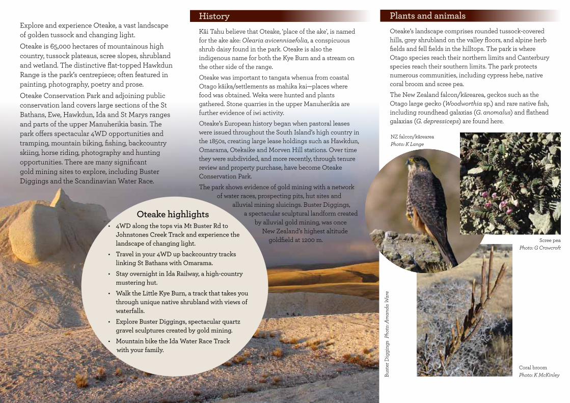
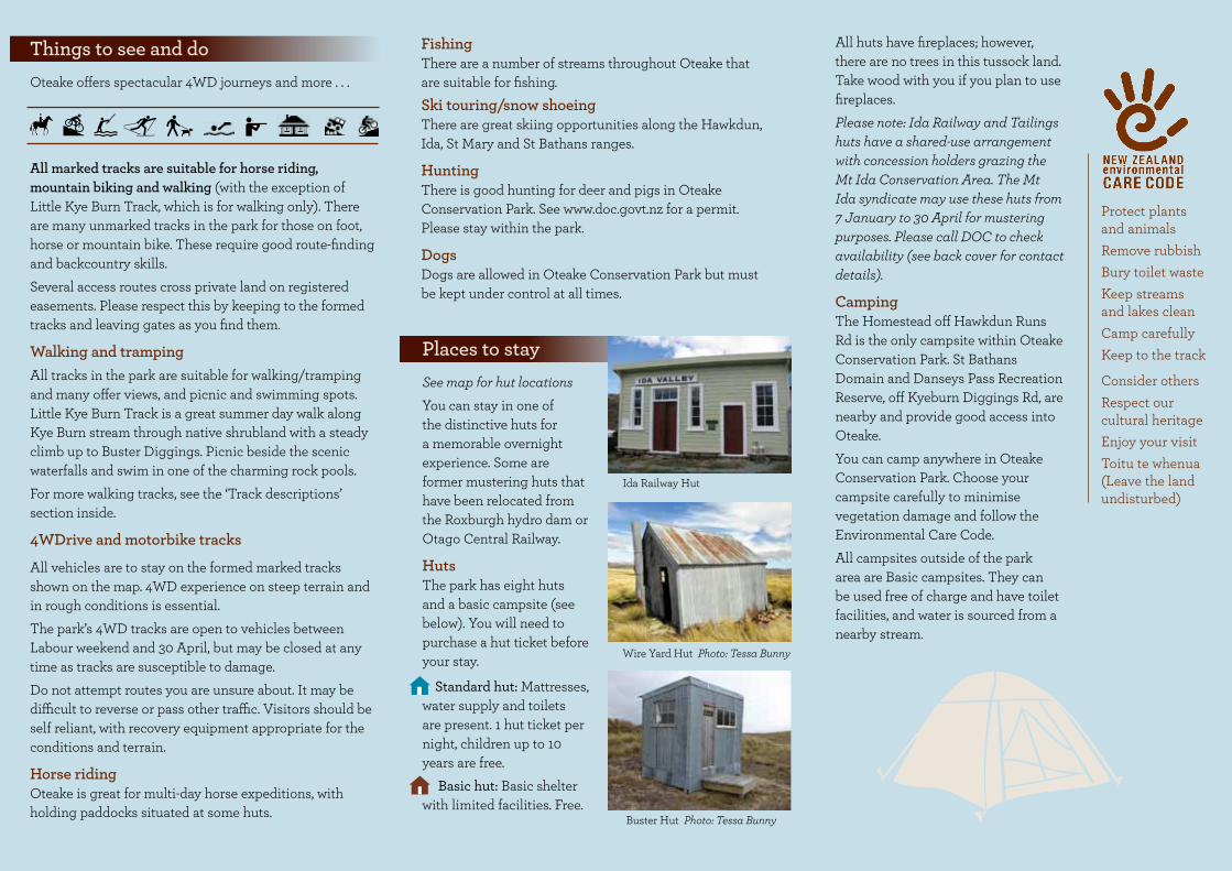
Places to stay See map for hut locationsYou can stay in one of the distinctive huts for a memorable overnight experience. Some are former mustering huts that have been relocated from the Roxburgh hydro dam or Otago Central Railway.
Huts The park has eight huts and a basic campsite (see below). You will need to purchase a hut ticket before your stay.
Standard hut: Mattresses, water supply and toilets are present. 1 hut ticket per night, children up to 10 years are free. Basic hut: Basic shelter with limited facilities. Free.
All huts have fireplaces; however, there are no trees in this tussock land. Take wood with you if you plan to use fireplaces.Please note: Ida Railway and Tailings huts have a shared-use arrangement with concession holders grazing the Mt Ida Conservation Area. The Mt Ida syndicate may use these huts from 7 January to 30 April for mustering purposes. Please call DOC to check availability (see back cover for contact details).
CampingThe Homestead off Hawkdun Runs Rd is the only campsite within Oteake Conservation Park. St Bathans Domain and Danseys Pass Recreation Reserve, off Kyeburn Diggings Rd, are nearby and provide good access into Oteake. You can camp anywhere in Oteake Conservation Park. Choose your campsite carefully to minimise vegetation damage and follow the Environmental Care Code.All campsites outside of the park area are Basic campsites. They can be used free of charge and have toilet facilities, and water is sourced from a nearby stream.
FishingThere are a number of streams throughout Oteake that are suitable for fishing.Ski touring/snow shoeingThere are great skiing opportunities along the Hawkdun, Ida, St Mary and St Bathans ranges.
Hunting There is good hunting for deer and pigs in Oteake Conservation Park. See www.doc.govt.nz for a permit. Please stay within the park.
DogsDogs are allowed in Oteake Conservation Park but must be kept under control at all times.
Ida Railway Hut
Wire Yard Hut Photo: Tessa Bunny
Buster Hut Photo: Tessa Bunny
Protect plants and animalsRemove rubbishBury toilet wasteKeep streams and lakes cleanCamp carefullyKeep to the track
Consider othersRespect our cultural heritageEnjoy your visitToitu te whenua(Leave the land undisturbed)

Mountain biking Oteake offers tracks for the beginner through to the adventurous. Some popular mountain bike tracks are:
Half dayMt Ida Water Race Track 18 km (GRADE: Easy) A great family trip with views and opportunities for smaller loops.
Full dayEast/West Manuherikia Track Loop 44 km from Hawkdun Runs Rd (31 km via Saddle Ridge Track. GRADE: advanced) 41 km starting from Broken Hut Rd (GRADE: intermediate) There are many river crossings on West Manuherikia, and a steady climb after Top Hut. Saddle Ridge track is steep; for an easier gradient but longer ride take Broken Hut Rd.
For more tracks suitable for mountain biking, and details on track grades, see the ‘Track descriptions’ section inside.
East
Man
uher
ikia
Tra
ck
Phot
o: P
hil O
liver
1200
1100
1000
9000
800
700
600
Ele
vatio
n (m
)
Distance (km)0 2 4 6 8 10 12 14 16 18 20 22 24 26
Bou
ndar
y C
reek
Hut
Top
Hut
Omarama Saddle
The
Hom
este
ad c
amp
site
(H
awkd
un R
uns
Roa
d)
Bro
ken
Hut
Roa
d c
ar p
ark
West Manuherikia Track
1600
1400
1200
1000
800
600
Ele
vatio
n (m
)
0 5 10 15 20 25 30 35 40 45 50 Distance (km)
Taili
ngs
Hut Id
a R
ailw
ay H
ut
Bus
ter
Dig
ging
s
Mt
Bus
ter
Roa
d c
ar p
ark
Hom
e H
ills
Run
s R
oad
car
par
k
Mt Buster – Johnstones Creek Track

N
Oteake Conservation Park
Other public conservation land
Locked gate
Basic hut
Standard hut
Derelict hut
Camping area
Information
Parking
(Please contact DOC for combination)
Public foot / mountain bike access
4 wheel drive access
85
83
8
83
83
82
)(
)(
1 2
3
6
4
5
1 2
4
6
7
5
8
3
LAKEBENMORE
Hidden Lake
LAKEWAITAKI
LAKEAVIEMORE
WaitakiRiver
FallsDam
Man
uher
ikia
Hut
Duc
k
Blue
Hut
HutShepherds
Johnstones
Dunstan
seiffuG
Boundary
Otemata
ta
Burn
Kye
Ota
mat
apai
o
Kurow
Awak
ino
Rock
Parsons
Clear
Gle
n
Manuka
Ck
Ck
Otekaieke
Otiake
Omarama
Stm
Riv
er
Creek
Ck
Creek
Ck
Ck
Creek
Ck
CkR
iver
Rive
r
Riv
er
River
Riv
er
Stm
maert
S
River
HU
TBR
OKE
N
ST B
ATHA
NS
MT
DANSEYS
HAW
KDU
N
LOOP
BUSTER
PASS
HOME HILLS RUN RD
RU
NS
RD
RD
RD
ROAD
RO
AD
LittleOmarama SaddleOmarama
Saddle
Mt BusterMt Ida
Mt BitternessMt St Bathans
Kohurau
Mt St Cuthbert
Mt Weta
Mt Kyeburn
Blackstone Hill
Mt Domet
OtekaiekeHill
Mt Misery
1333 m1690 m
1902 m2088 m
2015 m
1558 m
1435 m
1636 m
990 m
1942 m
1172 m
1448 m
1357 m1273 m
(8 bunks)
(8 bunks)
(4 bunks)
(12 bunks)(12 bunks)
(Historic)
(3 bunks)
(2 bunks)
(4 bunks)
Ida Railway Hut
Wire YardsHut
Chimney CreekHut
Green GullyHut
Tailings Hut
Hut Creek Hut
Brown Hut
BusterHut
BoundaryCreekHut
Top HutOtamatapaioHut
0 5kilometres
ST
BA
TH
AN
S
DU
NS
TAN
RA
NG
E
WE
TH
ER
R
AN
GE
HA
WK
DU
N
I DA
WALKING SPUR
ST
MA
RY
S
EW
E
RA
NG
E
RA
NG
E
RANGE
RA
NG
E
RA
NG
E
Becks
St Bathans
Hills Creek
Wedderburn
OturehuaNaseby
Kurow
SailorsCutting
Aviemore
Hakataramea
Otematata
BusterDiggings
Pierces Gorge
to Omaramato Omarama
to Oamaru
to Palmerstonto Alexandra
Danseys PassRecreation Reserve
HomesteadCamping Site
St Bathans Domain
Ford
Ford
Ford
AwakinoSki-field
Rel
ief m
ap b
ase
supp
lied
by G
eogr
aphy
x (N
Z) L
td
Otago
Rail
Centra
l
Trail
Access permissionrequired
May 2014
Lauder BasinConservation
Area
KillermontConservation
Area
Michael PeakConservationArea
OtamatapaioScenic Reserve
KirklistonConservation
Area
KakanuiConservation
Area
OteakeConservation
Park OteakeConservation
Park
Timber CreekConservation
Area
Ewe Range Track
Otamatapaio Hut Track
Saddle Ridge Track
Mutton CreekTrack
Berwen Track
Homestead Track
Mt Ida Water Race Track
Little Kye Burn Track87
6
5
4
3
2
1
1
2
3
6
4
5
West Manuherikia Track
East Manuherikia Track
Johnstones Creek Track
Mt Buster Track
Hut Creek Track
Mt Kyeburn Track
SHORTCUT
ROAD
BROKEN HUT ROAD
8
8
83Omarama
Manuka CreekTrack
Access to Broken Hut Road
Ahuriri Rive
r
NZTopo50 map index
CA14
CB14
CA15
CB15
CA16
CB16
CA17
CB17
8
82
83
85

Track descriptions
Please note: While most tracks are suitable for tramping and horse riding, they are also 4WD tracks and cover vast country.
Access from Broken Hut Rd car park (660 m)
NZTopo50 maps CA15 CB15
East Manuherikia Track 19 km Steady 5 km climb from the car park to Little Omarama Saddle (1357 m) and then a long descent to Hawkdun Runs Rd.
West Manuherikia Track 25 km The track travels along the flat before a steady climb to the Omarama Saddle (9.5 km from the car park), providing an easier gradient than the East Manuherikia Track. The track descends steeply to the valley with numerous river crossings to Hawkdun Runs Rd.
Saddle Ridge Track 7 km A rough and steep climb that links the East and West Manuherikia tracks with spectacular views of Aoraki/Mt Cook. Also accessed from Hawkdun Runs Rd.
Ewe Range Track 6 km This track climbs steadily through private farmland. You will encounter rocky outcrops and then a view towards Lake Ohau from the top of Ewe Range (1350 m). From the saddle, this track provides access for experienced trampers and backcountry skiers (in winter) to explore the Hawkdun Range.
Access from Otamatapaio Station car park
NZTopo50 map CA15
Otamatapaio Hut 20 km Off SH83. There is no formed track for the first 8 km up the riverbed. After a bridge over the Otamatapaio River, the marked track begins and follows the river. Stay on the marked track. As a courtesy, please contact Bog Roy Station 03 438 9400, as their property is beside the river.
Track grades
Walking track—easy to moderate walking from a few minutes to a day.Track is mostly well formed, some sections may be steep, rough or muddy.Suitable for people with low to moderate fitness and abilities.Clearly sign posted. Stream and river crossings are bridged.Walking shoes or light tramping/hiking boots required.
Tramping track—challenging day or multi-day tramping/hiking.Track is mostly unformed with steep, rough or muddy sections.Suitable for people with good fitness. Moderate to high-level backcountry skills and experience, including navigation and survival skills required.Mountain bike gradesEasy—mostly flat with some gentle climbs on smooth track with easily avoidable obstacles such as rocks and potholes.Intermediate—steep slopes and/or avoidable obstacles possibly on narrow track and/or with poor traction. There may be exposure at track's outer edge.Advanced—a mixture of long, steep climbs, narrow track, poor traction and difficult obstacles to avoid or jump over. Generally exposed at the track outside edge. Most riders will find some sections easier to walk.
Access from Hawkdun Runs Rd
NZTopo50 maps CB15, CA15
Homestead Track 1.7 kmShort track that follows an old water race and starts at The Homestead campsite.
Manuherikia tracks From Hawkdun Runs Rd, a 4WD track crosses open grassland for 3 km to a junction. From here you can go up either Manuherikia River East or West branch to the Omarama Saddle and into the Mackenzie country. West Manuherikia Track 25 km Rough track with many river crossings. It is a steady and scenic climb up to Omarama Saddle (1260 m) then down to Broken Hut Rd. See the extensive stone work on the Scandinavian Water Race that provided water to the gold mine at St Bathans.
East Manuherikia Track 19 km Popular, well-formed track, climbs steadily to Little Omarama Saddle and down to Broken Hut Rd.
Mutton Creek Track 6 km Links the lower sections of the West and East Manuherikia tracks. A shorter loop option for cyclists and trampers, this is a rough track with a very steep climb at both ends.
Saddle Ridge Track 7 km A rough and steep climb that links the East and West Manuherikia tracks with spectacular views of Aoraki/Mt Cook. Also accessed from Broken Hut Rd.
Berwen Track 4 km The track crosses private farmland and links the East Manuherikia Track with the Hawkdun Range.

Access from Home Hills Runs Rd
NZTopo50 map CB15
Mt Ida Water Race Track 18 km A well-formed track with a gentle gradient. The track can be accessed from three 4WD tracks: Shepherds Hut Creek Track, Hut Creek Track and Pierces Gorge.
Johnstones Creek Track 33 km Recommended for experienced 4WDrivers. From Home Hills Runs Rd (720 m), the narrow, rough track climbs steeply onto the Hawkdun Range (1620 m). The track follows along the crest of the range, then follows Walking Spur with two steep climbs and a river-crossing before the Mt Buster and Hut Creek Track junction.
Mt Kyeburn Track* 14 km Recommended for experienced 4WDrivers. From Buster Diggings (1200 m), the track follows the ridge below Mt Kyeburn (1560 m) where the track becomes narrow and exposed, and drops steeply to Danseys Pass Rd.
Access from Danseys Pass Rd
NZTopo50 map CB16
Mt Kyeburn Track 14 kmA narrow and exposed, steep climb to Mt Kyeburn. Also accessed from Mt Buster Rd.IMPORTANT NOTE: Vehicle access on Mt Kyeburn Track is restricted to protect the historic gold workings from damage. Access can be obtained by contacting the DOC Kā Moana Haehae/Alexandra Office (see cover).
Access from Awakino
Permission is required to drive up Awakino Skifield Road. Contact the DOC office in Twizel for access information.
Access from Mt Buster Rd
NZTopo50 map CB16
Mt Buster Track 28 km After crossing the Little Kye Burn (660 m), the well-formed track climbs steeply to the Buster Diggings (1200 m). The track then descends into Guffies Creek with numerous river crossings.
Hut Creek Hut Track 15 km It is 8 km from the track junction to Hut Creek Hut. Beyond the hut, the track becomes rocky, steep and narrow. The track ends at the park boundary with no access to the Waitaki valley.
Little Kye Burn Track 5 km Popular walking track (600 m climb) that travels up the Little Kye Burn through remnant tōtara and native shrubland to the spectacular Buster Diggings and Buster Hut. A great trip in summer, view the scenic waterfall and swim in the rock pools. From the Oteake Conservation Park entrance, travel along the flats to the start of the gorge and marked trail.
Along Kye Burn Photo: Tessa Bunny
Mt Kyeburn Track Photo: Malcolm Langley Photo: Matt Sole
Manuherikia tracks Photo: John Robinson
Photo: R Wardle
Berwen Track Photo: John Robinson

![project appraisal document (pad) - P166538 (Final)...s^> s o µ } ( ^ ] ] o > ] ( t t ( ] } o Z ] o ] v / v À u v W } i t t } o v l t,K t } o , o Z K P v ] Ì ] } v z>> z } ( o ]](https://img.pdfslide.us/doc/110x75/5fe39b73ebe5ce13dc01d30f/project-appraisal-document-pad-p166538-final-s-s-o-o.jpg)