Embed Size (px)
Citation preview
The following file is part of the
Arizona Department of Mines and Mineral Resources Mining Collection
ACCESS STATEMENT
These digitized collections are accessible for purposes of education and research. We have indicated what we know about copyright and rights of privacy, publicity, or trademark. Due to the nature of archival collections, we are not always able to identify this information. We are eager to hear from any rights owners, so that we may obtain accurate information. Upon request, we will remove material from public view while we address a rights issue.
CONSTRAINTS STATEMENT
The Arizona Geological Survey does not claim to control all rights for all materials in its collection. These rights include, but are not limited to: copyright, privacy rights, and cultural protection rights. The User hereby assumes all responsibility for obtaining any rights to use the material in excess of “fair use.”
The Survey makes no intellectual property claims to the products created by individual authors in the manuscript collections, except when the author deeded those rights to the Survey or when those authors were employed by the State of Arizona and created intellectual products as a function of their official duties. The Survey does maintain property rights to the physical and digital representations of the works.
QUALITY STATEMENT
The Arizona Geological Survey is not responsible for the accuracy of the records, information, or opinions that may be contained in the files. The Survey collects, catalogs, and archives data on mineral properties regardless of its views of the veracity or accuracy of those data.
CONTACT INFORMATION Mining Records Curator
Arizona Geological Survey 1520 West Adams St.
Phoenix, AZ 85007 602-771-1601
http://www.azgs.az.gov [email protected]

PRINTED: 11/21/2002
ARIZONA DEPARTMENT OF MINES AND MINERAL RESOURCESAZMILS DATA
PRIMARY NAME: ARMISTICE GROUP
ALTERNATE NAMES: SHORT KELLY
COCHISE COUNTY MILS NUMBER: 112
LOCATION: TOWNSHIP 23 S RANGE 20 E SECTION 25 QUARTER NW LATITUDE: N 31 DEG 24MIN 27SEC LONGITUDE: W 110DEG 16MIN 53SEC TOPO MAP NAME: MILLER PEAK - 7.5 MIN
CURRENT STATUS: PAST PRODUCER
COMMODITY: LEAD SILVER COPPER GOLD LODE
BIBLIOGRAPHY: ADMMR ARMISTICE GROUP FILE KEITH, S.B., 1973, AZBM BULL. 187, P. 64 WILSON, E.D.,1951, HUACHUCA MOUNTAINS IN ARIZONA LEAD & ZINC DPSTS, AZ BUR MINES BULL 158, P 40

ARMISTICE GROUP REFERENCES
Cochise County MILS Index #112
ABM Bull. 187, p. 64
Miller Peak, AZ 7.5' Topo (included in file)
COCHISE COUNTY HARTFORD DISTRICT T23S R20E Sec. 25 NW

Medium-duty
8 QUADRANGLE LOCATION
ROAD CLASSIFICATION
Light-duty
Unimproved dirt_
) State Route 25-8 -.lYl!.I±ER PEAK, hI:?
N E/ 4 S OrrnYStBE=I~'=QtfA'DRANG-6E_ N3122.5-WII015/7.5 r'
1958

Mr. Lon l.el1y J
Heref'ord, Arizona..
My d.eer Mr .. Kelly:
\ I am. returning berewi th co.p;;.!' or engineering Report -Lead-Bullion Mins in the Hartford Mining District. Hu.achuca Mounta'ina, Cocblse,County:, Arizona, which· ftS sent to us to be filed with the iALOOBTICE GROUP.
This report has been copied and 00P1 att8ched to mine owners re.p<:>rt in ou.r tiles.
At any time in the future tb.eJ.t you b.av'8 additional information on this property. I shall be glad to· have you 'send it to me - the more detailed informa tion I have on fil$ the more ·in·tor.rne.. t10n I. am able to pr~~~t top1"Ospective buyers.
" ':. ;,: \: ~~;; '.~ .
Assn ri·n.g you of my desl re to be hel pful J
and with be~~t w1ahes l I am.
JSC-jrf encla.
REGI~}TERED MAIL
Yours very truly.
1 .. s ... Coupal Director'
RETURN RECEIPT RE<tU'h"STED.
a~_ .... ~w:~~~w . ifa.ll'rER.
U »~4S<) . . :::'U U ~C/II'lIJeC/ f:l .... ·1-rZ"'· ~
I1known ••••• ""Ii ~ It~ 0 InSult. '. se(f
M, (Ciant a'"' . • • . . . .' ••••• • OVed. L I1dr.3Ss ••.• '"
IVa ' eft fi:~ .".,!, . . • • • •• O
such 01,. '''~<'0!:l.'''' ~ ••• () 'tUfe' · .. a;). • . no r re . III :''fate •.•••••
tnalf 't Ni' •••• '. • "-,$ eI1V~' • <i'OPS
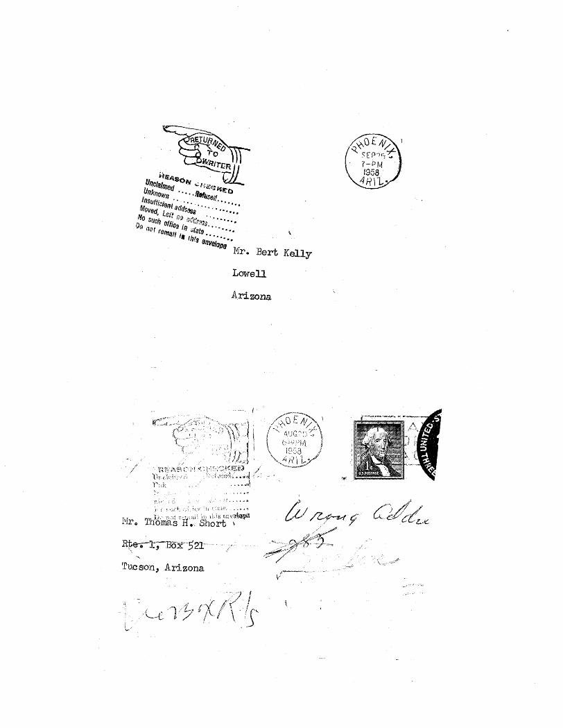
}fIr. Bert Kelly
Lm-rell
Arizon.a
i
.'~:
Tucson, Arizona
, ,~. .'

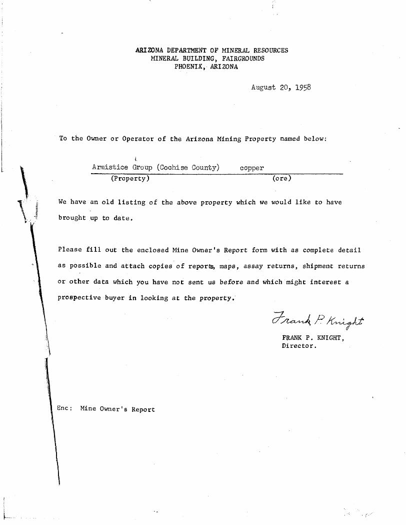
ARIZONA DEPARTMENT OF MINERAL RESOURCES MINERAL BUILDING, FAIRGROUNDS
PHOENIX, ARIZONA
August 20, 1958
To the Owner or Operator of the Arizona Mining Property named below:
t Armistice Group (Cochise County) copper
(Property) (ore)
We have an old listing of the above property which we would like to have
brought up to date.
Please fill out the enclosed Mine Owner's Report form with as complete detail
as possible and attach copies of repor~, maps, assay returns, shipment returns
or other data which you have not sent us before and which mi8ht interest a
prospective buyer in looking at the property"
Ene: Mine Owner's Report
FRANK P. KNIGHT, Director.
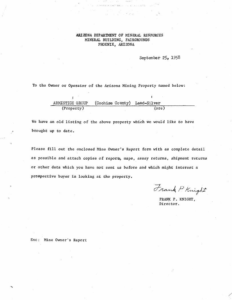
ARIZONA DEPARTMENT OF MINERAL RESOURCES MINERAL BUILDING, FAIRGROUNDS
PHOENIX, ARIZONA
September 25, 1958
To the Owner or Operator of the Arizona Mining Property named below:
f
ARJYIISTICE GROUP (Property)
(Cochise County) Lead-Silver (ore)
We have an old listing of the above property which we would like to have
brought up to date.
Please fill out the enclosed Mine Owner's Report form with as complete detail
as possible and attach copies of repor~, mapa, assay returns, shipment returns
or other data which you have not sent us before and which might interest a
prospective buyer in looking at the property.
Ene: Mine Owner's Report
FRAN!< P. KNIGHT, Director.
/
\ , ...•.. j
'f, )t'.~ ,
ARIZONA DEPARTMENT OF MINERAL RESOURCES MINERAL BUILDING, FAIRGROUNDS
PHOENIX, ARIZONA
August 20, 1958
To the Owner or Operator of the Arizona Mining Property named below:
l.
Armistice Group (Cochise County) copper (Property) (ore)
We have an old listing of the above property which we would like to have
brought up to date.
Please fill out the enclosed Mine Owner's Report form with as complete detail
as possible and attach copies of repor~, maps, assay returns, shipment returns
or other data which you have not sent us before and which might interest a
proapectivebuyer in looking at the property.'
Ene: Mine Owner's Report
."
FRANK P. KNIGHT, Director.
.,',
.:r~J ~r"l.> co. ~ ,~ 'I, 1/ r ¥ 1../ .


n }!; T URN 'r 0 ~ - ._ ...... ~ .. ....-_....-.... "..--.... ""'iI!'._, .. -. _l. ......
:~~linir~,g Bl'ar .. ch War :~~I'oduction BOf'..:cd
Washington, D. C.
N:lfllC of' Cmn:C;c,l.ny
MINING BRANCH SOCLflL B}~CUHITY BUILDING
WISHINGS;()N i ,D. C.
~!IE'T.!U.J II/LiN J1-::8
W' __ "' ..... _~ ................ _ ..... _,._ ..... , .. __ ._ .. __ .. " .. 'of{_ ...................... _.~ ........ ,_ ............ _ .... _,..._ •. ,., ..... : ...... __ : .... "l. ......... ~~ ..
INS T RUe T ION S .. _ .................... ;.o...~ __ ........ , ._' .......... _._ ... .,. ... _ • ..--................ ~, .. , ...... ..
To be filled o~t fo~ 08Ch r;·.etel m: .. n:Lng un] t :('i):C wl~.~,.c:j:!.
r;.;:3 Ej ~i. s·t [tD. c; Ci l Jl11Cl fj~:· I:Jx~t;:[' ~.~ 11;. ~~,: .. .;.. (; ~.\.J.
r2~ing or~er P-56 is 10-s.i:.cecl t.
j\,1 e:t cl()11ar ,
tJ"IJJ:lbcH: years in I)roducti::ll1
sr.·j.:ppod In 191+1 ~i_.J:'_Z_'f()_.;2::~ .. 1.- no.f ~
, "
6.
rt ( . In
A, B.
r'< \.,.1 b
_;'~-::._:">_.~.~_)" ___ ...... __ . __ . __ •... _._ ._ .. « •••••. ~ •.• _._ •• _____ • __ ~ •. ". "~~_~ __ "~_'''_'h __ ._. _. _____ .• __ ... _____ ~ __ •. __ •. ~ ____ .' .••
I "i) (':1;:-',.1 . (J6·'t 11 ~r ) ~--~-- ..... --~.-- .... ,--.-.-.-... -.- .. -~-- ....... - .... --... -'~----'--.'- ---.... -.. '".-... ~,.----.- ~--.-.--.-.. -.- .. --.-----'., D. _.J, .. r __ ,,, ___ ,~._,,_. ~ ___ .;. __ ... _ '.'''~ __ ''' __ '' __ ..... _ ..... -~_ ..... _ .. ~ .. _ ... -., .. _""".~_"_. __ ._..,,._ ......... ~_~ ..... __ •• ____ .... __ • __ •• "" __ • .....- ..... ____ _
9 ~ Numocl"' of shifts op~rated at I}reeont _..,...l_ .. ,,,~j)C~~L.' day
IS 0 e t i orl)5~A) ·-of"---:Cl-io-U;"1.i t 'OQ- \ Istutos Criminal C)do, 18 ,U.S.C.A. 80, makes it a I
I criminal offense ·to rtla.ko 0.
fo.loe f;1tatomor:t OI' roprosontnI tion to any dG})ur-:;mcnt 01'
I~goncy of tho Uni~ed states as
Ito Hny mattor wi thi.n ltH juris-' . di ct ipn "-____ .
~{li:j.e anclorn:lgrwd COT"c;j.fios that tho ath)VO lnformation 1.d com~;Jlote und ccJIl, ... or;"t; to tho bost of his k:::lovJlodgo

R~ IT: T U Ii. N T 0 ~-. ·-·3r{l;:~1·;~g·-ir,;ill: ch'" War :~:;~coduction Bon:;:d
W&Ghington, D. C.
MINING BRANCH SOCIAL BEGURi.~~Y BUIIJDING
WISHINGTON;; D. C.
Ml::'I'AL MIN F,s
.I~ .~! '".~?~ ... T:.}1~}L.Q. .... :l~L ... 9 _ ,~~~'" ,:~~ 'I'() be fLLl Gll. 01i"\; fo~:' Cl~;, ch :::'.etcl m~.nt::'1.g unJt fo:c wt~:
.N flGlC 0 f C om:JaD.;~l CS8ist~ncs unde~ p~3f8rs~c0
rating or(er P-56 is desi:.c"edo
... ____ ..... ..:,_ .... ··~· .... _AJ ........... ""_ •• _ ... ~~· __ •• __ ..... ",.-... - __ .:_,_ ... _...__ ... ~ .... _ ... " ... _ ..... _~t_ .......... ~ ... ·_ .. · ..... :_4_._..-...
Not dollar v~luGof matori[~s stippod in 1941 1l;,J- 7 J.{ 0 • b-O .1 ....... .- _ ....... _ ..... ___ .~ iM_ .. -. .....
I" ) . Hew is tho mino 1evelQ~2(: L.Lc~,}Tt •. O·l.·r.> ct'l'.o+ C! '\ 'OT lO 11 Tt'-'c U .. ,-1 ... 1 ... \) .... )~ ....... '!~ __ .JI JJ_ . 0._ • of Drifts I j-O ._ ... --_._-........
6.
t"1 ( . In
[I J:l.',1
B. _ ... ..--_-.. ,.~~_ .... _ .......... "' ....... __ ._. ........... ..-._ ........ __ ........... .,.. .............. _ ....... ,,_ .. ______ ....... _ ........... ~::.. .. __ o,...-._. ___ ,_ ....... ~ ... ,~ ......... _ .. ~ .. ___ ~ __ , . ..-.004_ ... _____ ~_. __ .... _. __ , .. ~ ... ...
Cn D.
(~Ivlut r:.1. ) _. ___ ..... _.~ __ ..... , ___ ._.,._ .... _~ .... ,_, __ ... , __ ,_. __ ~. ___ ~ ____ ._._ ......... ~' ...... ' .. 4_.~ ........ _ ... _._ , ___ "' __ ._._ .• _. __ ... ~ __ ~, \ 0 t:h c.r ) _ ...... __ ..... _ .... _ .. __ .... ,. ___ .. __ ' ___ '0'''' ..... ___ .• --____ •. _._ ... ,. __ .. _._ •• __ . __ ~"_._._.,._. __ ._ .. _. ____ .... _0 •• __
8. l\!'l.mbor Of 0I)1-o10··'·(·~'8ct >"It n .... C;qoI·lt I J..~ \... - ....... ~"J; J .... ... ,,- L. 1:"·1. .... v ............ _ ..... _ .. .;. ..... ___ .-.. ......... ___ ._ .. ___
9. Num.bor of sbif.ts oporated at t)rElFJOnt
1.11:1.0 '..lndot'EJ:Lgnc;d COT'Gi.fios that tho abovo informati.on IS0ction j""5"rA)"of-:-Lho U11.i f(JQ-'\ id com~;)lc·t;(J ancl cOlree-c, to ttw best of his knuvJluc1gc 'l-) \_4. VU .... 1. ~ ... U... J t~l, _ 0 \",l.. I. )..,.If,::!.,!. ... ; .. 0 ~
U.S.C.A. 80, Irla.kes it a I ~7- .. __--I1 Ic,tr'tn(":l Cr'im;nr'l (;-)d"" lQ 'l'lli hr 'lO ('F l. ~
1 crimincl offense "GO m2,lu) n I _ ... _ ....... .pr~~~ .. _~__ ., _. .~~. fnloe stutcmer"t o:c roproscntn- ~ fj .j:)GJ~':;tM)
I tion to nny department or ."?::i..:_--,~t:L/z4I:::)~.!..-/Ji.~ .. _.' _. .. ____
I,-,g,.=mcy of tho U~li-:.::;d [?tat~s .. ~s 0... . ".. . (Slgnat~n.>3 Of.· ~Cio.l) to 8.n'] matti)r wltllln J.ts Jurls-o ~~",~ .. 1..J.J..!:L~_. ___ . __ . _. _ _ __ _
Idic:tiQn. _______ ' ___ . __ . (Date)' (Title

\
U
Mr,. Thos:jf flo Short, Route 1~ Box 521. ·Tucson jri Ar1zo:n.a.
November 2, 1942
! have your le·tter of October 27 together wi, th neopy of your application for 0. serial nUlnber~ I arri vel"':! muoh afraid. that; there would be no opportunity whatsoeV(ilr for gettins a serial number for a mine employing only Qua lUan., OJ11y working one shift e. day) and only produoing one ton a. d.~l.y~ .
Vlhil~ thoro is no arb! trary rule ~3.S to the number of men employed to qualify for a seI¢ial number, it is not oust()lnary '1;0 151 va ·one for lasel th8.l1 7 or g Inen!t and sometimes 10. As to whether or not a serial number f.;hould be granted depends upon the qU~ltlti"ty of strategic l1letti":l.l produced"
or course, you automatioally op0'rste under P .... l00 \,lhio11 anti tIes you to put in PD l~a rQQ.u.este for any s1!~30inl t1quipmont that you n.eed tb:at you Cal1Ilot :puroh~!se 'Und.er trH) 'Ole.Met P-100 order.
I ap:prceiats lf of courge~ that until you. gBt a serial number ;1011 are unzlolo to buy th{:~ tools and equipment to employ mo:r;*'Q men. It goes round and rou.nd <!oj you canllot~lJ)loy:i;4o.li'lon until you get the tools alia you oannot hire the man (~~~l yqu. geii. .t~e tQorus:· and aquip.:''11ent Q
If~ hO't'1ever~ it is your intention to ernploy more men and need more tools alld equiprnetrt it 'will be possible to gfrt a serinl number if you. express your intontion and pla.ns~
..:: -' ~ .
III tho meantime ! ~nould suggest that you fulfill your re"", quil"t=Jmonts by~t~~e .u,aool:· PD.':l~a'·fortn:~.~· YOtlOan get the blank forms from Mrs Wa.lsh e.-b the War ·Production Boal~d o:efj;ce in Tt).cson~
It" yO~.~trG·· ma!Cin,!];p.l~nE f't)'P .. : tnoreaS'ingyOtl;r :prodtiotiorf'and . :the nuxnJJ0r of men employed, I would su.ggest that :rou conret' with George Balla.lil ft
fi~31d engineer 01'> the Deprll~t:merd~ C,)f Mineral Resources~ Box 1..,95. Tllcson~ re.:lav'l:v0to 1th~ .application rora~erial number based· upon, yohr:·;t)r.crposed aotivities.


rI!
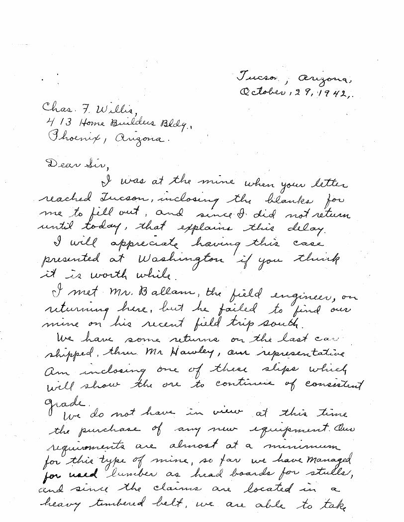
Mr. Lon Kelly l Hereford, Arizona..
My deer Mr. Kelly:
\! am returning herewith oopy of engineering Report -Lead-Bullion Mine in the Hartford Mining District, Hu.a.chuca Mounta-ins, Coehise1
CountY.J Arizona., which was sent to us to be filed. with thelAHMISTICE GROUP.
This report has been copied and copy att~ched to mine owners report in our tiles.
At any tirne in the future that you have additional informatlonon. this property, I shall be glad to have yOU. send it to me - the. more detailed information I have on fils the more information I am able to pr~~9.1!t to prospective buyers.
: .;':::':: ·~;·~~r~.' ..
Assuring you of my desire to be helpful, and ~'1th best )1isbes l I am
JBO .... jrf encls.
REGISTERED MAIL
Yours very truly.
1. S. Ooupal Direetor'
RETURN RECEIPT REQ;UESTED.

" .. - - .•.. - ... ~ -.-.--.------ . __ . __ ._- - ----.-
""

il
ABM Bull. 187, p. 18
~e . ~l I
NAM$ OF },UNW.: ARMISTICE
DAT.Jll: i 1.. .' t-. '.-
5/1/44 : Thomas H. Short,Rt. 1, ! Box 521, Tucson i
I j
I I I I
I
. I
\'
t
it
OOUNTY: OOOHISE DISTIllOT:
. , .. Mlll~;qu lID'1m STATLTS-
5/1/44 Sh1p:ping 6/46 Idle
5
/ I (

Chase H. Dunning Ariz. Dept. of Mineral Resources Phoenix, Arizona
Dea.r Sir:
Superior, Arizona July 26, 1949
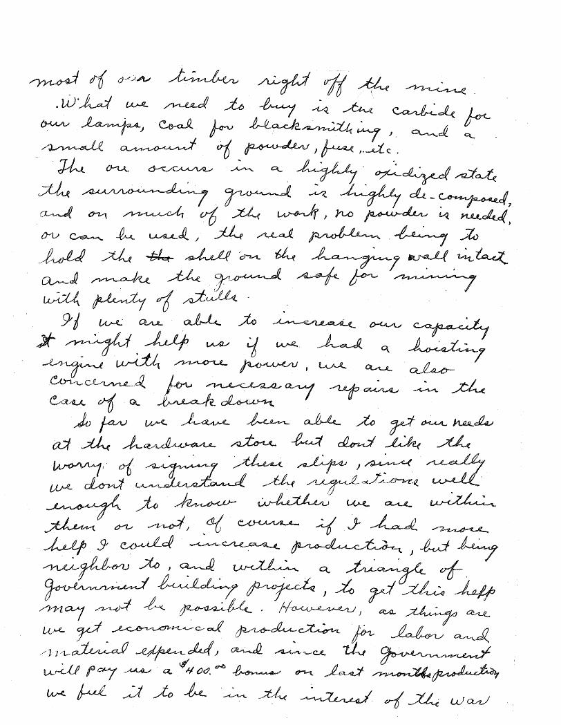
We are sending you a brief description and map of the t
Armistice claims located in the Huachuca Mountains. lNe stoppe:i
operation there in April and would 11ke to lease or sell this
property. We would appreciate any help you could give us. We·
will be glad to answer any questions you may have about the mine.
For the next sixty days our address will be P.O.Hox 698
Superior, Arizona.
Our more permanent address is 156 E. Roger Road, Tucson, Ariz.
Sincerely Yours ., f\ d '~di 0-. 1'3. lA'v{lO\); -
;..../~-4 0 jl -I Vi. vI"~' 4A'~~ A.B. Short V.T. Short
f
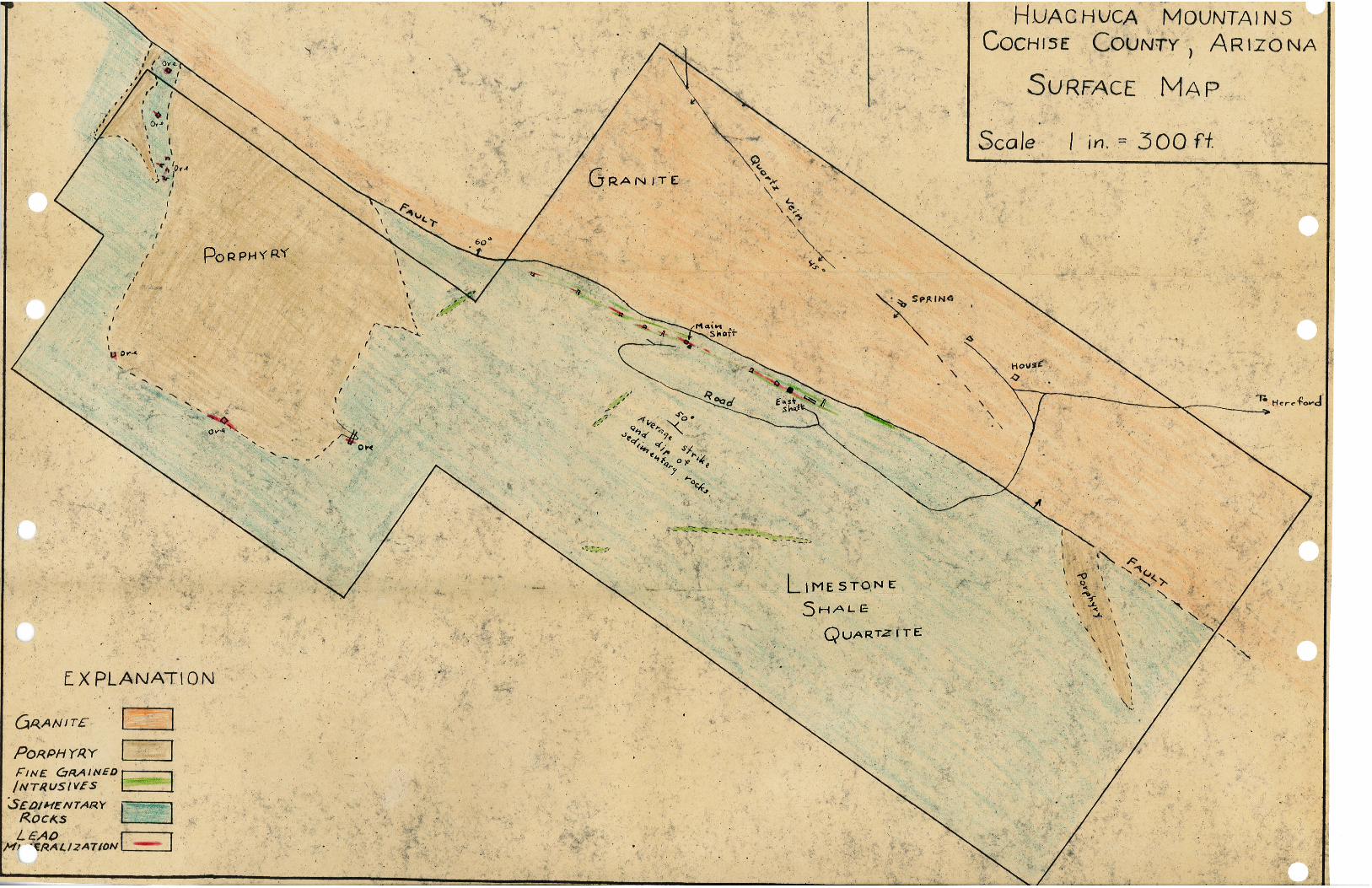
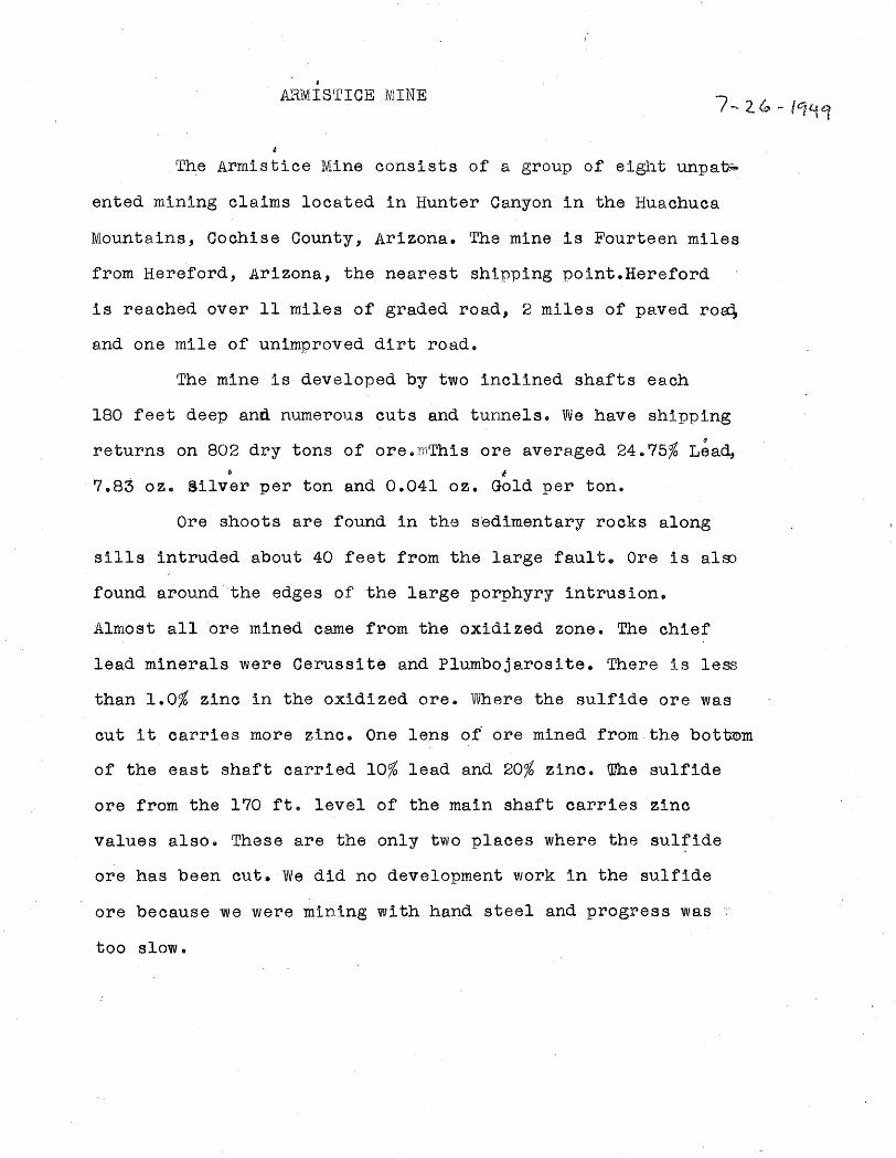
ARlVIISrrICE :lVlINE
,The Armistice Mine consists of a group of eight unpa~
ented mining claims located in Hunter Canyon in the Huachuca
Mountains, Cochise County, Arizona. The mine is Fourteen miles
from Hereford, Arizona, the nearest shipping point.Hereford
is reached over 11 miles of graded road, 2 miles of paved ro~
and one mile of unimproved dirt road.
The mine is developed by two inclined shafts each
180 feet deep and numerous cuts and tunnels. We have shipping IJ
returns on 802 dry tons of are. rnThis are avera.ged 24.75% Lead, ~ f
7.83 oz. Silver per ton and 0.041 oz. Gold per ton.
Ore shoots are found in the s'edimentary rocks along
sills intruded about 40 feet from the large fault. Ore is alro
found around "the edges of the large porphyry intrusion.
Almost all ore mined came from the oxidized zone. The chief
lead minerals were Cerussite and Plumbojarosite. There is less
than 1.0% zinc in the oxidized ore. Where the sulfide ore was
cut it carries more zinc. One lens of ore mined from the bottmm
of the east shaft carried 10% lead and 20% zinc. IDhe sulfide
are from the 170 ft. level of the main shaft carries zinc
values also. These are the only two places where the sulfide
are has been cut. We did no development work in the sulfide
are because we were mining with hand steel and progress was
too slow"

FORM ZA ~OM 11·47 CAIRNS AP"~RICAN SMELTING AND REFINING COMP)' ~'Y
EL PASO SMELTIN@ WORKS
ORE SETTLEMENT EL PASO, TEX.~S. ~i~~:~Jl·tl*£t·f~ 8M EL TER' LOT __ -"<P....,~7~.~~'""ii;=~·}_· _____ _
SOU G HT 0 F ___ -"'l""';~m. .. ""'.1*!:.l· ... ~.,--"'i;~t~""~s"""~"":r .... ts",,·,'---,,,~~,:r,,,,.--,,·~~-,·'ltll!-'J'X~,-,'l>_;:.,.::.w;@'-",~~"",lI"".1'....!~t",,·~,--______ . __________ _ S H I PP E R'S LOT----w~~l------ADD R ESS ______ ~-_--"~'-"{!2lo@>l>;r-':'~""(.)=f'-"¢~··~~"'-~"i.:;.,~""l,lil_. -",-;~~~rr....;.~t,w .. t;'~';~n~r.5:!*!;;"",;t=--_______________ _ CLASSI FICATI ON_""!f; .... \l,..,,"'it .... :'f ____ _
SHIPPING POINT !it; 1:~ NA M E 0 F MIN E~~,,b.'::-i·l (~·tt~JM~
CAR WEIGHT IN AVOIRDUPOIS POUNDS N Y. METAL Q'UOTATIONS
NO. INITIAL GROSS SACKS NET WEIGHT .MOISTURE DRY WEIGHT ______________ , ___________ If _______________ :· __ ~N~O~· ___ I, ___ VV __ E_IG __ h_T __ .~---_____________ % ________ ~-------"
S~ttl~nv~nt Date .ll"""z9<u~4.g B/L Da_t_e-: ___ ....;;i;~l .... .sw:. -=:: .. ~:;:..;,t..;.;: -="lIi;~~L;,;;.·1:---_
EL.EMENTS
Gold
Silver
Lead
Copper
ASSAY PER TON 2000 LBS.
fiOj !~i .• ~~,;;
2{).~)
4JJ/Z'~l
oz.
oz.
%
%
Silver 1t\.)o~) Cts. per oz
F'gn Silver: i,',{} ~Q
Lead ~~ __ ~~~E:~1~9~~~t~a~~ ___ P __ er __ Io~o~l~bs E. & M.J.
Copp~r Cts. per lb
PREMIUM MEfAL CONTENT
bead ________ --.:~ __ J.bs
Copper lbs
PAYMENTS FOR METALS VALUE
DEDUCTED NHT ASSAY
:t.t;· J.,o~~
]j;:~~
l~6f; lir~'1i!$ P~;it
EQUIVALENT PE.RCENT NET PAID FOR RATE AMOUNT AMOUNT IN LBS. PAID FOR . PER TON TOTAL
-------I------------.------I-----------~I----------I~--~~-oz.
oz.
lbs.
lbs.
~~,.;~ ~':1(~·.5 ,.~~i;~:
..1'9')
TOTAL PAYMENTS FOR METALS
DEDUCTIONS DEBITS CREDITS
BASE CHARGE: F. O. B. El Pase, for Metal Payments, net exceeding ~ ______ per ton
____ % of $ _______ exc~ss over $ _______ per ton
Handling Sacks
~b 'GIDlR~D~ficiency ·1n .. ~~ 'Bullion. Freight Tax
ANALYSIS DEDUCTION NET"
Insoluble
Silica
Iron
Mn
Lime
Zinc
Sulphur
Alumina
As
Sb
Bi
Total Value on .
Less Freight on
~j5 • .J~~ 2?4 J,).~.l~
"'J -¥'Ii
~~~.~J t~.~.i7 5.·!,r~·
fflJ? lJJ~fiJ .,..,
%
%
%
%
%
%
%
%
%
%
%
Amount withheld pending receipt of Silver Affidavit
Royalty
%
%
%
%
%
%
%
%
% %-
%
Dry Tons @ 5~:5 ~£~~~ Wet Tons @ ~ i.'!'
. ;;Q'~ii'~ Hauling Charge
Swit&:hing
Umpires
@
@
@
@
@
@
@
@
@
@
@
RATE
<:its.
Cts.
Ct:s.
Cta.
Cts.
Cts.
Cts.
Cts.
Cts.
eta.
Cts.
1.1; .10
Per Ton
Per Ton ~~, :~;~~. at ~JJ~ ·it ~l •. :~ i~ '$~,t1;r~~
BALJ.~NCE DUE SHIPPER
Valuation for freight per wet ton $ $:~ A .<'(/.
DEBITS
!'1$i5{}
~3~:~ ~!;:l
--Z?t)lll ~:;~; -1/.-------'~~J .... -"lM: .. :A ~ If
Made by ___________ 8-aecked. _____________ Cor,rect _______ ._ ... _____ Appro.ved ___________ -,... __
. ~ ."-{: ... :
.~
", w. E~rf.;;,V\HriY
'~~~~l~~:~ ELP-AS?O. T~XAS
J~QX: 4
----_._----_ .... _-_ ...• -_._ ... -'-'--' .. ,~. .
F. L.HAWiLI;Y
&H'~!i!x!Z~V~S I.d '; t;A:~i'I, :'-'- '. . . . ...., .< '. '". .. 191~'v;j,;[i~;I1¥ &·,.rt;A.:)W~L;EY
W;:'E,;H~WkE,t.,MAN'A~~ER
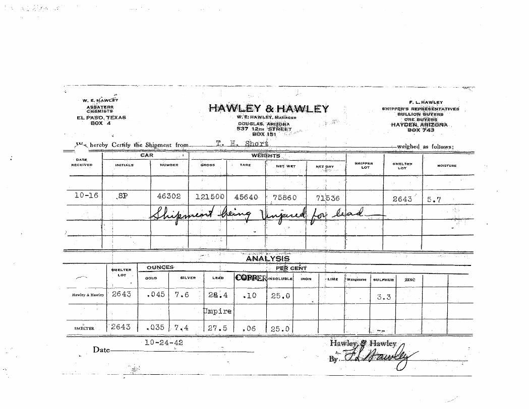
~=~.T rV1~. hereby Certify €li)~e S'h,i~,~ent . from T~:.. R.; .. ·shori '.:,'reiigl1eqa's follo.cw$;
.. :., \AI!~~r.~Ji4;T$ D'A''J',E,
REeEIVED
10-16
... ""----.....
I·
INITIALS'
)3P
$MELTER
LOT
Hawley & Hawley I' 26 4 ~
S:.~fELT:ER '2643
CAR j
·NUM·BER
46302
.~ -. ':.' .• ,1_
1f
9':lJ'N.9ES'
G'Ol:D SiI:LVER
.045 ?Q6
., Q35 r ? *,4
10-24-42
GROSS TAR:;;: Ni;·:rj WET
121t5·00 45640 l' 75860
U ... ··:··,v:.;·,·,· ~: , .. ~-~~.I:l-~--) ,;: -:'," . ;-': \ I· . ;.
.'{ 1!J '.~
,.;
-
'1 ;!-.--.:-::.::~.:;~~-:.; .:t-.:~.
A4N,A:Ikc'Y?,liP '.r.'~"'~" .
.. t·.: ~~~i~··.,€E~1
1
N;ET:~av .. ";:~:":::
r::"
?1~36 ., ..
SHtPPER LOT
1.'; _\ t,: ~ __ ~ ~
SM'ELTEf/ Lo.'I'
2643
LE~P (!&fl.~~.I~SQLU-~LEt IRON LiH.':E M:anltanesel SU'LPHU'R' ,ZINC
"
2g).~ 4 .10 25.0 3 .. 3
Ompir@
27.5 .. 06 25.0 . , ..
D,ate-----:------..:.-----'-----:--__ ~ __ _ :~~ .-----'-"'-~- .. -----.- ..
M·O.-STURE
5.7
~~:-

PORM 210. 20M 7·"2· CAIRNS AME~"f.lCAN SMELTING AND REFINING COMPA~'''I
EL PASO SMELTING ,WORKS
ORE SETTLEMENT EL PASO. TEXAS.IO .... 27~A2 SM EL TER LOT ___ 2_6_4.t..=3'---___ _
BOUGHT OF __ ~_ .• =-·_f.=I:...::.~S=1:.::..10_=:_· =r-=t=---_____ . ___________ _ ADDRESS ________ --~H~!e~r=-e __ f~·o~r~d~'~2-=A=r~1~·=Z=O~n=a~·. ________________________ _ SHIPPING POINT t1 n
SH I P PE R'S LOT _________________ _
CLASSIFICATION Ore NAME OF MINE Armistice
CAR
I WEIGHT IN AVOIRDUPOIS POUNDS N. Y. METAL QUOTATIONS
NO. INITIAL SACKS
NET WEIGHT MOISTURE
DRY WEIGHT Settlement Date lO-16-Jt2.'
GROSS NO. WEIGHT % BIL Date J O-J :3-Lj 2 .
Silver . • 7062, Cts. per oz ..
46302 SP 75860 5.7 71536 F'gn Silver • 4475 Lead ~ 6e~O Per 100 Ibs,
E. & M.J. .11650 Copper Cts. per rb,
PROVIS IONAL PAYABLE METAL CONiENT
Lead lbs,
Copper lbs.
PAYMENTS FOR METALS VALUE
ELEMENTS ASSAY PER TON EQUIVALENT PERCENT
NET PAID FOR RATE AMOUNT
I AMOUNT
2000 LBS. DEDUCTED NET ASSAY IN LBS. PAID FOR PER TON TOTAL
Gold ~O35 oz. .035 oz. 32.3+825 1.13 Silver 7.4 oz. 1.0 6~4 6.4 oz. .69125 4·42 Lead 27., % 1.5 26.0 520.0 90 468.0 Ibs. " 0.4,9 22.93 Copper, ~o6 % Ibs.
TOTAL PAYMENTS FOR METALS 28.48 DEDUCTIONS DEBITS CREDITS
BASE CHARGE: F. O. B. EI Paso, for Metal Payments, not exceeding 15.00 per ton· 3.50 ]0 % of ~ 13.4 B excess over ~ 15~QO per ton 1~35
Handling Sacks . . Copper Deficiency
ANALYSIS DEDUCTION NET RATE
Insoluble 25.,0 % % @ Cts.
Silica '19.0 % % @ Cts.
Iron 15.5 % % @ Cts.
Mn % % @ Cts.
Lime .4- % % @ Cts.
Zinc 1.0 % % @ Cts.
Sulphur 3.4 % 200 1.4 % @ 025 Cts, .35 Alumina 3.4 % % @ Cts.
As .72 % % @ Cts. Sb .12 % % @ Cts. Bi % % @ Cts.
TOTAL DEDUCTIONS 5.20 5.20 NET VALUE PER TON I 23.2S
DEBITS CREDITS
Total Value on .35.768 Dry Tons @ 23.28 Per Ton 832.6$ Less Freight on 37.9.30 Wet Tons @ 3.29 Per Ton 124.79 Less Demurrage Hauling Charge . . . -LeiS Representation Switching 2,63 Less Du~y and Brokerage Umpires
Amount withheld pending receipt of Silver Affidavit 59.02 Royalty
BALANCE DUE SHIPPER 646 t! 2LI• Valuation for freight per wet ton ~ 21.25 632.68 8.'22.6$
Made by _______________ Chedced _____________ Correct ____________ Appl'Oved, __________ c--

c-o-:p ... y
ENGn~1!;ERING REPORT
t LEAD--BULLION M[NE
IN THE
liOUHISE COUN1~-, ARIZONA
BY
E. L. Me ELVENNY
MO·fLi ~UIN'l!;ERING 00. JjI~JjEE, ARIZ9NA
__ .. .., ..... : _-a __ ..

" '''-'~~
MOTZ El\jGIN~~ING COMPANY El'JGINEERS & ABS.P:iERS
P. O. Box 919 BISBEE, Arizona
:,! Ralph L. Motzl
Linden T. MCElvennyl i~ Registered Professional Engineers .:,:i,
Bisbee, Arizona·.:
--::------------------------------------;--------------------------~-----------:..-------i l:tjfAj)-B~UI1!~j)vlll1$.I,.':~~ __________________ d
------------------ ~
Examined and sampled between ~anuary 5th and 12th, ~928, by L. T. Mc.l!:lvenny, E. M.
'l'he Lead-Bullion group of mining claims lies in the
Har.t:eord Mining District, hJuachuca Mountains, COG;b.ise
County, Arizona at 11 miles west of Hereford, a station
on the Southern Pacific Hailroad. Douglas, the smelting
center of the southwest, at which is the lead smelter of
the Phelps Dodge Corporation, is about 40 miles by rail
from Hereford.
The claims cover the north fork of Hunter uanyon
and reach, at their wester'extremity, the divide between
Hunter Canyon and Miller uanyon.
Elevation above sea level at the eastern end of the
group is 5200 feet, at the western end is 6000 feet, and
at the main shaft is 5700 feet.
Good county roads connect the mine with Hereford, the
-shipping pOint, excepting the first one and one-half miles
below the mine. If he mad is all doWn grade from the mine
to Hereford e An erpenditure of $200.00 will make a good
road throughout.
A fresh water spring on the Spring claim provides
enough water for domestic and ordinary mining purposes.
~
'! "~
.... ~. .
".
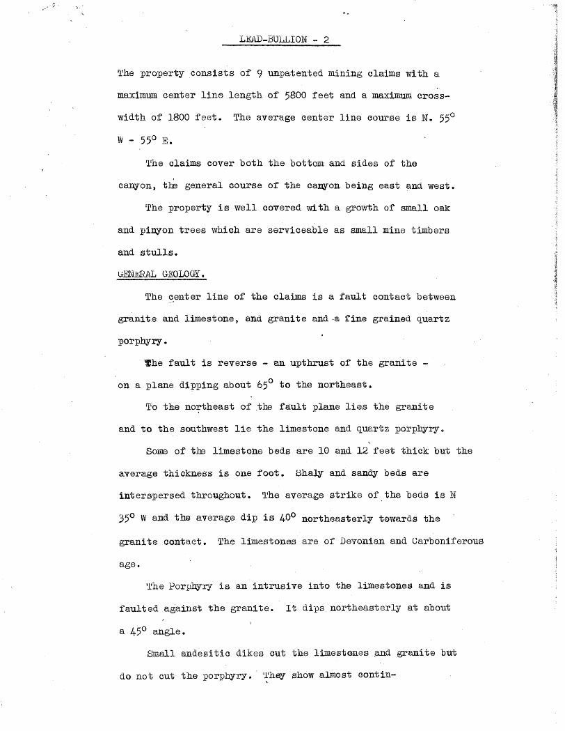
LEAD-BULLION - 2
l l he property consists of 9 unpatented mining claims with a ,.
maximum center line length of 5800 feet and a maximum cross-
width of 1800 feet. The average center line course is N. 55°
sr1he claims cover both the bottom. and sides of the
canyon, the general course of the canyon being east and west.
The property is well covered with a growth of small oak
and pinyon trees which are serviceable as small mine timbers
and stulls.
(;EN.Iilli~ G],'OLOGY.
The center line of the claims is a fault contact between
granit.e and limestone, and granite and a fine grained quartz
porphyry.
~he fault is reverse - an upthrust of the granite -
on a plane dipping about 650 to the northeast.
To the northeast of .the fault plane lies the granite
and to the southwest lie the limestone and quartz porphyry.
Some of the limestone beds are 10 and 12 feet thick but the
average thiokness is one foot. Bhaly and sandy beds are
interspersed throughout. ~he average strike of the beds is N
35° Wand the average dip is 400 northeasterly towards the
granite contact. The limestones are of Devonian and Carboniferous
age.
Irhe Porphyry is an intrusi va into the limestones and. is
faulted against the granite. It dips northeasterly at about
a 45° angle.
Small andesitic dikes cut the limestones ~ granite but
do not cut the porphyry. l~lhey show almost contin-

.' .. ~. . ~\ .
L~-BU~LION - 3
uously along the granite-limestone contact and are older than the
are.
The granite is a batholith accounting for the elevation of
the whole of the Huachuca Mountains.
iVllNHilV.
A shaft haS'been sunk at about the center of the Bullion
Ulaim, an inclined distance of 182 feet or a vertical distance of' 134
feet below the collar • 'fhe inclined angle is 450 to the northeast.
The shaft is in good repair. Water level rests at 114 feet vertically
below the collar.
The footwall is limestone and the hanging wall is a green
andesitic dike.
From thC? shaft, work has been done on the 50 foot, 100 foot,
140 foot and 180 foot levels, for the details of which see the attached
map.
Ifhe shaft followed down on an 8 inch str8ak of lead corbonate
ore which widened at the 100 foot level to over 24 inches. At this
point about 20 tons of ore were taken out and the shoot passed into the
footwall 01'· the shaft at a dip angle of' 65°. It was again picked up
on the 140 foot level in the crosscut back under the shei't where it
is 21 inohes wide with iron and lead sulphides along side of it.
ORB;S
tfhe or'e 1"8, as encountered so f'ar, lead in the form. of
carbonate and sulphide together with gold and silver. No zinc nor
manganese has been found. Iron Oxide accompaiies the ores down to a
depth of 104 feet below the s~face at which point pyrite begins to
come in.

:,.'
LEAl) - BULLION - 4
The ore oocurs in ~hoots along the strike of the limestone
beds with dips grading from the 450 dip of the limestones to a dip
of 650 corresponCling to too granite contact.
These shoots have been found at the granite contact and at
pOints almost 100 feet fran the contact. N~~o-l'~:~,has been f'ound in
the granite.
A lim! ted amount of prospecting has opened shoots v8.rying from
8 inches to 4 feet in thickness of u~nown but rather short lengths.
One shoot opened'on the surface is 4 feet 2 inches wide and is un-
covered for 65 feet in length. One end of this ore is still under
the ground-soil overburden.
Surface gouging has uncovered ore values for a length of 1200
feet along the contact.
PORPHYHY
The p~~phyry in places is mineralized extensively with iron,
and, at several points on the limestone-porphyry contact are found
lead ore stringers of commercial grade in wide iron mineralized
zones.
The limestone-porphyry contact on the Lead Bullion property has
not been prospected and the showings above mentioned are exposed on
claims belonging to George Dunn adjoining the Lead Bullion.
The following samples were all taken from the ore zone
immediately southwest of and parallel to the granite-limestone contact:
From the various shallow pits northwest of the main shaft on the
Bullion C-1aim, none of which exceed 5 feet in depth, I took out samples
L~ - BULLION - 5
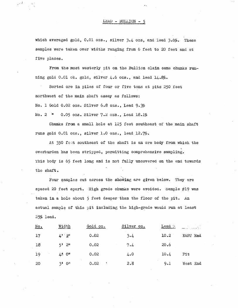
which averaged gold, 0.01 ozs., silver 3.4 ozs, and ·'lead 3.6%. These
samples were taken over widths ranging from 6 feet to 20 feet and at
f'ive places.
From the most westerly pit on the Bullion claim came chunks run-
ning gold 0.01 oz. gold, silver 4.6 OZS., and lead 14.8%-
Sorted ore in piles of four or five tons at pits 250 feet
northwest elf the main shaft assay as follows:
No.1 Gold 0.02 ozs. Silv-er 6.8 OZ8., Lead 9.Jfo
No.2" 0.05 ozs. Silver 7.2 OZS., Lead 18.1%
Chunks from a small hole at 125 feet southeast of the main shaft
runs gold O.Ql ozs.) silver 1.0 ozs., lead 12.7%.
At 350 fa .;;:t southeast of the shaft is an ore body from which the l
overburden has been stripped, permitting comprehensive sampling.
'l'his body is 65 feet long and is not fully uncovered on the end towards
the shaft.
]lour ~ample s cut across the sho~ing are given below.. They are
spaced 20. feet apart •. High. grade chunks were avoided. f:3am.ple #19 was
taken in a hole about 5 feet deeper than the floor of the pit. An
actual samplE? of this :pit including the high-g~ade would run at least
2-5% lead.
No. Wid:!ih Gold oz. Silver oz. Lead '/~
17 4 t : aU 0.02 3.4 10 .. 2 EAST End
18 5' 2" 0.02 7 .. 4· 20.6
19 4:t., Oll 0.02 4.0 10.4 Pit
20 3- on 0.02 2.-8 9 .. 1 West End

· ... r$'
LEAD - BULLION - 6
At 67 feet east of sample #17 is the beginning of another streak which is 37
feet long as exposed in a trench.
Samples taken at regular intervals from west to east show:
'No. Width Gold oz~ Silver oz. Leas ~
12 I' 0;1 0.01 2.6 10.6 West End
13 It 4" 0.01 2.6 9.4
14 l' 1" 0.01 1.8 5.2
·15 l' 4" Trace 0.6 O~-7
16 It 2tt 0.01 2.4 9.4 East End
The trench at samples 17 and 20 is 54 feet below the collar of the
shaft, and from 12 to 16 is at 83 f.eet below the collar of the shaft ..
Sample No.9, at 92 feet east of sample No. 16, taken in a shallow
hole 2 feet· wide runs: Gold 0.02 oz., Silver 2.2 ozs. and lead 6.0%. The
main ore shoot has not been cut.lat this pOint.
Between 25 and 30 tons of ore were sorted from the trenches covered by
samples ,12 and :ff20 which will ~ssay,~.· 25% lead and 10 oz. silver.
There has been on prospecting east of sample #9.
Samples in the shaft are as numbered on the map:
No. Width Gold S ilver Lead
1 gil 0.01 0.2 0.3 100' Level Xeut to Granite
2 4' ~n 0.01 0.2 0.2 Same
"'~\
3 19' olt 0.01 0.2 0./+ same
4 I1t all O.ria ffi.«$ 1.3 Same \"'~'.
5 Sit 0.01 0.1+ 1.3 ~t;~9?ns·t Limestone . ~ " 6 21tf o.at'S 6.2 22.4 Ore Shoot 14°- level
\'\~\ 4~'\"~~ll,,:
.\~~\'.
7 rrrace 0.2 0·3 Face i'"
8 lOU 0.10 8.0 19·9 Ore Shoot 50' level
\~~$)
9 12' ;ti)rt 0.01 0.4 0.4· Shaly limestone.
.":""f ,. ,
.,' ~I; .
LEAD - BULLION - 7.
Sample #6 is the downward extension of the ore which was mined in t'he shaft
at" the 100 foat"~ l~vel and which seems to have an eastwardly rake.. The 21
inches of ore at this point is on the footwall wide of the mineralized break.
'rhe hanging wall is here flattening and is producing a wider m.ineralized zone,
including 24 inches pf leached material running 5% lead and a 12 inch streak
. of iron and lead sulphides of about the same lead values. The sulphide ore
shows only in the bottom of the crosscut. No attempt was made to cut this
ore on the 180 foot level, but some galena and :pyrite were picked up.. 'l'he
main ore streak would be back of and to the east of the shaft at this level.
'l'he v'art-ieal extent of the pay ore below the 100 foot level is 34
feet. The lateral extent is unknown. On the 100 foot level the streak was
followed westerly for about 30 feet, the are showing diminishing width ..
The 100 foot level crosscut, cutting through the altered shaly lime
beds and eventually reaching the gra¢ te, failed to ex-pose any further oommer-
cial ore but show a width of 55 feet of leached ma:terial containing much
iron oxide and some lean lead values throughout.
In May, 1926, the company shipped 38.3 dry tons of are to the
American S1llelting &. Refining Company at El Paso. This shipment netted !\p1ge31
per ton after freight dedu.ctions at the smelter. The smel-tier returns showed:
Gold 0.05 OZ .. , Silver $.9 ozs. lead 20.12%. All of this ore was mined from
the shaft.
The drift on the 50 foot level exposes a 10 inch streak of carbonate
ore assaying 19 .. 9% lead, 8 ounces silver and 0 •. 10 ounces gold. (See Sample tl8) ..
It lies in the hanging wall of a divergent fracture which has been encountered
also on the 100 foot level in open and caved. ground and where the hanging wall
streak also carries good values. This streak was n0t cut on the 140 foot
level, and has perhaps raked to the eastward above this level.
·.' . ,," . ~" .
. .
~ bULL10N ---8
The exploration work done in the shaft and levels there off shows
that the main ore streak is getting wider and more persistent with depth.
Xt appears tbat the 100 foot level is the top of an are shoot.
The extent of this ore shoot is not known but the fact that it was picked
up in the first fandum crosscut driven from the 140 f'oot level shows that
it must be of greater extent laterally t.han on the 100 foot leve1.
I believe that this ore will persist eastwardly to connect with the
shoots shown by sampfues #12 to 20.
DEPJlH lU\fD EXTENT.
A cross section of the property shows that the limestone will reach
a minimum depth of 800 feet and will undoubtedly be cut by many tongues of the
mineralized porphyry which outcrops on the Dunn Claims.
This porphyry intrusion I believe to be a source of mineralization
for the whole area. 'Ilhis assumption cannot be sho.wn at the present time,
'but if it be true,. there is a possibiiity of greatly extending the ore zone
when these porphyry tongues are cut at depth.
The contact fault between the limestone and granite is of great
lateral extent, being traceable for several miles both northwesterly and
southeasterly, and at many.points along it lead ores are found, and at
several places the quartz porphyry is close to the fault and ore is found on
the porphyry-limestone contact.
EQUIPM~N""T :
The equipment on the ground consists 01':
1- 8 i1 x2.H gasoline driven air compressor --(Belt driven, ovmer L. J. Cox)
1- Jack Harnmer
1- Bullivan Tugger Hoist
1 Mine car
2 Mine bucket s
I I /, i

· .
LEAD - B,ULLION ~-'O " . t
also~ a drill steel, mine rails, pipe, and enough tools for 4 unaergottnd workers.
The water in the present shaft flows at about 15 ga.llons per minu.te.
TITLE:
The claims belong to Lon Kelly, L. J. Cox and '1'. o. McGrath, a part-
, nership.
They have surveyed and monumented the claims and location holes have
been dug to conform with the law, and assessment work has been. kept up.
However, a law suit has been brought against the owners by Max R.
VOIl Baumklrchner, claiming :prior location rights over a portion of the claims.
I have examined the case th.oroughly and can fin.d no grounds for his
contention and am positive that the case will be wen by the defendants.
FOR. SALE:.
Given a two year period for p~ents and a priviledge to stope
ore on a royalty basis to apply on purchase price, the property is worth from
'50; GOO to ,'iN)., 000.
It is of especial.appeal beoause of the faot that ore will be
encountered whic];i can be shipped direot to the smelter, 50 miles di,stant,
thus paying P8l"t of the cost of developm81t.
Should it become necessary to erect a mill, 80me souroe of water must
be sought. Probably the mine i taell will provide a eonsiderable f10w at
depth.
The equipment on tlB ground can be made to serve, Gut for economical
work, I would reeo:mrn.and aoquiring a new eompressor with engin.e, and 2 new
jack hammers. The new equipment would cost about i>5000 set up.
A prospective purchaser of this property would do.well to consider
also the property of George ]hmn and William Kelly ,comprising 10 claims
and a fraction.,
Some of these clailns are shown on the map. The other lie to south
, of' ... and adjoin the Black Oat claim.. I did not make a eOlllPlete examination of .--.. ,- .

,,' t--- ~,,'
LEAD - BULLION - 10
tlais property J but have shown OR the map the quartz porphyry body and the
various workings on the contaot -V1i th the limestone. In. these werkings,
considerable high-grade ore has been uncovered.. No hQle is over '20 feet
d'eep. George Dunn wants a tunnel about 220 feet long driven in under the
shwoing in the oenter of the Black Cat olaim to cut the ore at a.bout 150
feet belowth.e surface. Six months time will be given to do this work.
The purchase price is ,25)000. This property can be worked in. oonjuno,tion
Wi th' the Lead-Bullion.
OONCLUSION:
This area is well werth p'r.a§peating and will, I believe, develop
into a good mine.
Respeotful.ly submitted,
By L. T. I1cElvelUll
Dated at Bisbee, Ariz.
Jan. 14, 1928

~ ... :..,., ;';: ~\ .. ..
ASSAY REPORT
SHArrruGK-DEtm MINING OORPORATI0N
controls Bisb se, Arizona 1-20 . .1 '36
-, n
Description Au Ag Ph% CUjb
Oz. per ton Q.z. ;per ton
Monroe 0 tr 0
Blind Ledge .15 Oa 2a California 0 tr 6
San Bernardino .68 ~ 51
. (Signed) H. R. Iien.dricks Assa¥er

".
News Items
Location
Owner
Address
\
~O~p~er~a_ti_n~g_C~o~;_· ~~~.~.=~~ .. =~~~ .. ~. ________________ _ Address
Pres .
. Genl. Mgr.
Mine S:..:u.::=:P..:;t._~
lw:m Supt. . \
VriIlcipalM..etals Le4ld..,. Stll/.·~ . Meii Employed I Production Rate; ..
Mill, Type & dC~pacity. h
Power,Amt.· &, Type
1lt~12·~i~l:CJ: Gfl)llP,. ]3"ni:;eUv 1 Lo.well . .;~1zona
Your .... ·Qd·.tdH$.a.s,tieea ~~l'l~1.hG4.~tQ-:""
._a:rdsru'ttl,P.O.aox 1,23. Phoen1X,4rlzona
. Whe ·hu made req\1(.g$t t~r the s~m.e wl'h re:fe~reliloe 'to .1'.laB »1"01U1"' 118'ed with ilheDepa1"tnwnt of _ine-ral 2.eouro$ ••
'DIPARm~T or ~I~!!ti~R1£:~~ORCES 1.. 1!,. OOl.1pal. lli reotor

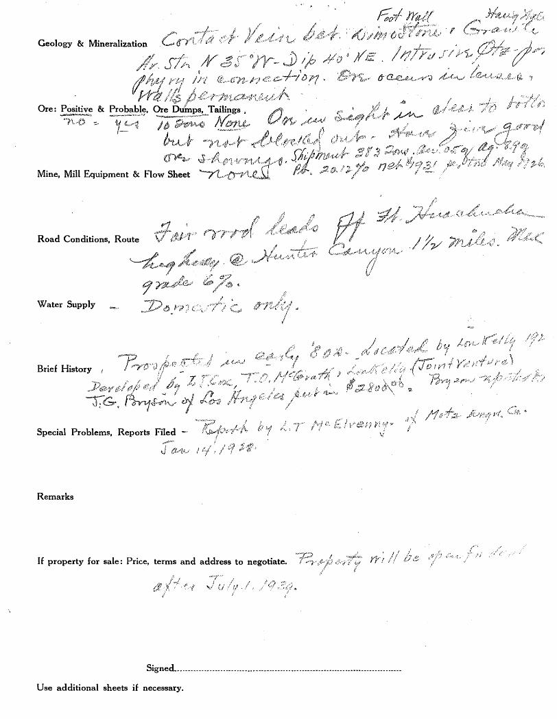
i Mine Armistice Group
DEPARTMENT OF MINERAL RESOURCES STATE OF ARIZONA
OWNERS MINE REPORT.
Date June 16, 1939
District Hartford, CoelLi·se Co" Location 11 mi. west from Hereford I}
Former name Lead Bullion (1926-29)
Owner ·1 Be~t Kelly Address
Operator Lo~ Kelly Address Hereford, tt
President No corp.
Mine Supt.
~ ! lJ ~ Principal Metals Lead-Silver (gold, scheel
Production Rate Cochise' 2- 5 . T 238, R 20 E
Power: Amt. & Type Not Bert Kelly,lLowell '42
Operations: Present Assessment work 0
Operations Planned Depends on financing
Number Claims, Title, etc. l1'i ve unpatented lode claim.s - on Coronado National Forest
Description: Topog. & Geog. North ]'ork, Hunter Canyon on south slope of divide between Miller Canyon. :~lev" of li1B.in shaft 5,7000
:.-..... , . . '
Mine Workings: Amt. & Condition 1 shaft (400 incl.) 186.1 300' dfts, . Shaft"· in fair condition and accessible eq;;cept 30' water in bottom. Numerous shallow workings
(over)

· f'oot ,'Vall hanging wall Geology & Mineralization Contact vein between ·limestone" - granite - Av.. str 0 N.. 35° W"
Dip 40' N.}~c> Intrusive Q,t~=p6rphyry in connectiono Ore occurs in lenses - walls permanento
Ore: Positive & Probable, Ore Dumps, Tailings ---- ---no . Yes 10 -~ons nOlle
Mine, Mill Equipment & 'Flow Sheet
Ore.in sight in clear to bottom but not blocked out. Have five good ore sho.wings ..... Shigment383 tons. An ,,05 oz. ag. 8.9 oz.. Pb. 20.12% net $19 .. 31 peT ton .May 1926.
Road Conditions, Route Fair wood leads off 1ft. lIuachucha Highway @ Hunter Canyon It miles. Most grade 6%
Water Supply Domestic only
~ e Brief History Prospe~ted in early \,80s 0 Located by Lon Kelly 1925. Developed by L.. fr.. Cos,
T.. 0 .. :McGrath, Lone Kelly ( Joint venture) J. G. "Bryson of Los Angeles put in ~~2,800 - Bryson re.ported O .. }{.
Special Problems, Reports Filed Report by L. fl1. 'III Ire rl:lvemlY -, ~I- t li' C J 14 1928 LV! ~ 01 1~10 Z .J.;Jngr.. 0.. an.., e
Remarks
If property for sale: Price, terms and address "to negotiate .. ' Property will be open for deal after
ATTACHED TO REPORT: July 1, 1939 .. Engineering Report Lead-Bullion Mine in Hereford Mg.Dist .. ,Huachuca Mts<!>>> Cochise County, Arizona, By E.,L.McElvenny,Motz EAgineering .Co:. l)
Bisbee, Ar,izona, date Jan .. 14, 1928.
Signed ___ .. _ . ___ . _____________________ . __________________________________ ... ________ . _____ _
Vl?e additional sheets if necessary,

DEPA~TMENT OF MINERAL RESOURCE5 , STATE OF ARIZONA
Mine
Former
Owner
Operator i (;) '-1
President - ~
Mine Supt.
Principal Metals
Production Rate
Power: Amt. & Type
Operati~~s:, Present ",~
Operations' Planned 3)e'i) -t:,'-~t,/ !
Number Claims, Title, etc.
,1\ ,/,,,-Description: Topog. & Geog. ~/ / l'f'''';J
Mine Workings: Amt. & Condition
OWNERS MINE REPORT
Date 0/( 6/.!Y(
'Address
Gen. Mgr.
Mill Supt.
,) Men, Employed
Mill: Type & Cap.
(j 1~)}/~~~f:~~Yl~'>" j
! ~I
r ,/ .l:. ~~ ~/ {./
Geology & Mineralization
Road Conditions, Route
Water Supply
Brief History
Special Problems, Reports Filed --..,.~ • ..'.:.l.'
t-,..i Ct~:,11.jtJ
Remarks
,(
~'fi"''J'~t,,;(~,:':{;/ /'
(i
J
1/ j,,;l ,.
If property for sale: Price, terms and address to negotiate.
'~'"l'''
'-!)' i:/ '/;l ' ./
r:ic;?f ira-t~/ ~j >~/;?,;;? ·c/ (f~{'~r;;;:i,::{>, ' !
.(J
::tl ."A~i~,~,~(/~('A .~<:,.?"."1,,; .. ,,,"" ~':J. ..• .'j
?It,.l/:;~,·'"~) "
~:d'
, 1./ / rJr( 1/ l? 1.;-;
./':,.
/'
Signed._. _______ .. ______________ .. ___ . ______ . ___________________________ . _____________ ... __
Use additional sheets if necessary.