Embed Size (px)
Citation preview

Considerations for Navigational Safety in the Marine Planning Process
1
Emile Benard ACPARS Project Manager
USCG Atlantic Area (LANT-54) 26 AUG 2014
15th Biennial Harbor Safety Committee and Area Maritime Security Committee
Conference

Coast Guard’s Role as a Cooperating Agency
2
• CG responsible to waterways users for safe and efficient operation of the Marine Transportation System (MTS)
• BOEM consultation w/ Coast Guard ‒ Safety of Navigation ‒ Traditional uses ‒ Impact to CG missions
• Navigational Safety Risk Assessment required of the developer
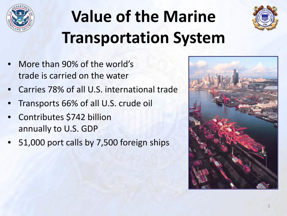
Value of the Marine Transportation System
• More than 90% of the world’s trade is carried on the water
• Carries 78% of all U.S. international trade • Transports 66% of all U.S. crude oil • Contributes $742 billion
annually to U.S. GDP • 51,000 port calls by 7,500 foreign ships
3

Impacts to Navigation Safety
• ∆ Vessel Density (collisions)
• ∆ Allisions w/ fixed objects
• ∆ Weather & Environs
4

Safety • Mixing Vessel Types • Complexity of vessel
interactions • Decreased Sea Room
5
Impacts to Navigation

6

UK Maritime Guidance Note MGN-371
7
Distance Factors Risk
< 0.25 NM Inter-turbine spacing = only small craft recommended Very High
0.5 NM Mariner’s high traffic density domain High
1.0 NM Minimum distance to parallel boundary of TSS Medium
1.5 NM S band radar interference - ARPA affected Medium
2.0 NM Compliance with COLREGS becomes less challenging Medium
> 2.0 NM But not near a TSS Low
5.0 NM Adjacent wind farm introduces cumulative effect. Distance from TSS entry/exit
Very Low
10.0 NM No other wind farms Very Low
RED
YELLO
W
GR
EEN

UK Maritime Guidance Note MGN-371
8
Distance Factors Risk
< 0.25 NM Inter-turbine spacing = only small craft recommended Very High
0.5 NM Mariner’s high traffic density domain High
1.0 NM Minimum distance to parallel boundary of TSS Medium
1.5 NM S band radar interference - ARPA affected Medium
2.0 NM Compliance with COLREGS becomes less challenging Medium
> 2.0 NM But not near a TSS Low
5.0 NM Adjacent wind farm introduces cumulative effect. Distance from TSS entry/exit
Very Low
10.0 NM No other wind farms Very Low
RED
YELLO
W
GR
EEN
> > 2 NM from route would be low risk except near a TSS

UK Maritime Guidance Note MGN-371
9
Distance Factors Risk
< 0.25 NM Inter-turbine spacing = only small craft recommended Very High
0.5 NM Mariner’s high traffic density domain High
1.0 NM Minimum distance to parallel boundary of TSS Medium
1.5 NM S band radar interference - ARPA affected Medium
2.0 NM Compliance with COLREGS becomes less challenging Medium
> 2.0 NM But not near a TSS Low
5.0 NM Adjacent wind farm introduces cumulative effect. Distance from TSS entry/exit
Very Low
10.0 NM No other wind farms Very Low
RED
YELLO
W
GR
EEN
5 NM is the minimum distance to the entry/exit of a TSS

UK Maritime Guidance Note MGN-371
10
Distance Factors Risk
< 0.25 NM Inter-turbine spacing = only small craft recommended Very High
0.5 NM Mariner’s high traffic density domain High
1.0 NM Minimum distance to parallel boundary of TSS Medium
1.5 NM S band radar interference - ARPA affected Medium
2.0 NM Compliance with COLREGS becomes less challenging Medium
> 2.0 NM But not near a TSS Low
5.0 NM Adjacent wind farm introduces cumulative effect. Distance from TSS entry/exit
Very Low
10.0 NM No other wind farms Very Low
RED
YELLO
W
GR
EEN
> At 2 NM from route COLREGS becomes less challenging

Other Guidelines • German Guidelines- A distance of at least 2
nautical miles plus a 500 m safety zone is necessary between the traffic separation areas and the wind generators.
• World Shipping Council- A minimum distance of 2NM from traffic lanes. Increase distance as vessel speeds increase.
• CESMA- Minimum distance equals distance to comply with COLREG 0.3NM+ 2NM+ 500m
11

International Regulations and Guidelines
1. General Provisions on Ships’ Routeing of International Marine Organization (GPSR)
2. United Nations Convention on the Law of the Sea (UNCLOS)
3. International Regulations for Preventing Collisions at Sea, 1972, as amended: (COLREG)
12

Confederation of European Shipmasters' Associations (CESMA)
Required Room for a Full Round Turn 13

14
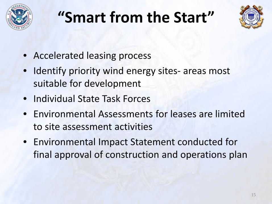
“Smart from the Start”
• Accelerated leasing process • Identify priority wind energy sites- areas most
suitable for development • Individual State Task Forces • Environmental Assessments for leases are limited
to site assessment activities • Environmental Impact Statement conducted for
final approval of construction and operations plan
15

16
Wind Criteria using proven technology 1. < 30 meter water depth 2. Near population (load) centers 3. Within 30 miles of tie-in point
Maryland WEA
Delaware WEA
New Jersey WEA

17

18

Remaining Conflicts
19
Tugs and Towing
Ongoing Challenges
• WEAs moving forward without addressing navigation
• State by State approach • Inconsistent process from one state to the next • Developers are under impression all conflicts are
addressed prior to leasing • Lack the modeling and analysis tools to calculate
changes in risk and cumulative impacts
20

Recommendations
• Address navigation early in the process along with other conflicts…consistent with the “Smart from the Start” approach.
• Identify navigation corridors necessary to ensure safety of navigation for all vessels along the coast.
• Better engage industry to identify areas compatible for both wind and navigation. 21

ACPARS Status
• Modeling and Analysis • Marine Planning Guidelines • Continue engagement with BOEM regarding
addressing navigation in leasing process • Navigation Safety Corridors
22

For More Information Contact:
Emile Benard ACPARS Project Manager
(757) 398-6221 [email protected]
http://www.uscg.mil/lantarea/ACPARS/
Proceedings Magazine http://www.uscg.mil/proceedings/
23

Backup Slides
24

Future Considerations Marine Highways
25
Maritime = Safer, More Efficient, Greener

Future Considerations Panama Canal Expansion
26

BOEM Four Stage Process
27
Planning and Analysis Leasing Site
Assessment
Construction and
Operations - Identify priority wind energy sites -Request for Information -Call for Information and Nominations
- Determine Competitive Interest - Proposed Sale Notice - Final Sale Notice
- Site Assessment Plan - Site Assessment and Site Characterization - Draft NSRA
- Construction and Operations Plan - NSRA Evaluation -Suitability Recommendation - Environmental Impact Statement
Intergovernmental Task Force Engagement