Embed Size (px)
Citation preview

Conservation Blueprint
for the
Donner Summit Royal Gorge Property
Prepared for
Sierra Watch
408 Broad Street, #12 Nevada City, CA 95959
September 2012

Conservation Blueprint for the Donner Summit Royal Gorge Property
Conservation Biology Institute ii August 2012
Table of Contents Page
1. Introduction 1
2. Regional Conservation Values 4
2.1 Natural Heritage 4
2.2 Biological Resources 9
2.3 Water Quality and Watershed Health 16
2.4 Forests 19
2.5 Cultural Importance 19
2.6 Sierra Recreation 22
3. Threats and Vulnerability 24
3.1 Habitat Loss and Fragmentation 24
3.2 Climate Change 24
3.3 Effects of Regional Land Use Changes 25
4. Protecting Our Investments 27
5. Literature Cited 33
Appendix A: Data Sources and Methods 37
Appendix B: Special Status Species 42
B-1 Special Status Animals with Known or Potential Occurrence at the Royal Gorge Property, Nevada and Placer Counties, California
B-2 Special Status Plants with Known or Potential Occurrence at the Royal Gorge Property, Nevada and Placer Counties, California
B-3 List of Vascular Plants Potentially Occurring on the Royal Gorge Property
B-4 Vertebrate Species with Known or Potential Occurrence at the Royal Gorge Property, Nevada and Placer Counties, California

Conservation Blueprint for the Donner Summit Royal Gorge Property
Conservation Biology Institute iii August 2012
List of Figures Page 1. The Sierra Nevada Ecoregion. 1
2. Ecological subsections of the Sierra Nevada. 4
3. Location of the Royal Gorge property in the Donner Summit area of the north-central Sierra Nevada. 6
4. Essential Habitat Connectivity in the Donner Summit area. 7
5. Importance of intact elevational gradients in accommodating adaptations to climate change. 8
6. Diversity of vegetation communities on the Royal Gorge property. 10
7. Riparian habitats and montane meadows in the Donner Summit area. 11
8. Potential habitat for the Pacific marten and California spotted owl. 13
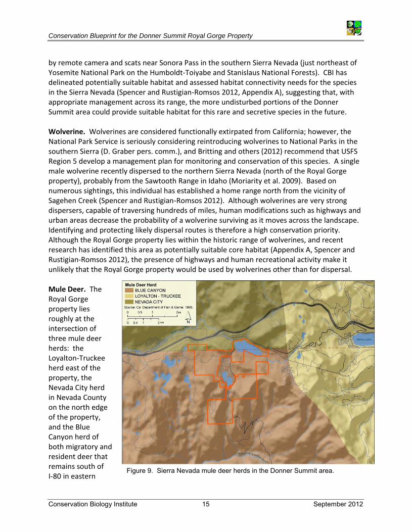
9. Sierra Nevada mule deer herds in the Donner Summit area. 15
10. Watersheds of the American, Truckee, and Yuba River hydrologic units. 16
11. Relative landscape integrity of Donner Summit area watersheds. 18
12. Royal Gorge forest inventory map. 20
13. Cultural importance of the Donner Summit area. 21
14. Major trails in the Donner Summit area. 23
15. Historic, current, and projected housing density in the Donner Summit area. 27
16. Land uses surrounding the Royal Gorge property. 29
List of Tables Page
1. America’s legacy of conserved lands in the Donner Summit area of the Sierra Nevada. 5
2. Vegetation communities of the Royal Gorge property. 9
3. Wetland habitats of the Royal Gorge property. 12
4. USFS rankings. 19

Conservation Blueprint for the Donner Summit Royal Gorge Property
Conservation Biology Institute 1 September 2012
1. Introduction The almost 3,000-acre Royal Gorge property on Donner Summit in the Sierra Nevada has long been a target of conservationists. Sitting at the cross-roads of the Sierra Nevada ecoregion−along the east-west Emigrant Trail and the north-south Pacific Crest Trail−and surrounded by protected and intact lands, this iconic property fills a significant piece of the conservation puzzle in the north-central Sierra (Figure 1). Scenery and history alone, along with opportunities for hiking and cross-country skiing, make this property a coveted target for development, as well as for conservation.
Background The history of the entire Sierra Nevada has been one of competing uses for resource values, ranging from wilderness to rural residential, from timber harvest to hiking, from solitude to ski resorts, with high political stakes and public visibility at the core of its saga. Nowhere is this more apparent than in the central and northern Sierra, where in the 1860s the U.S. government granted alternate square miles to the Central Pacific Railroad during the building of the transcontinental railroad, thus establishing a checkerboard pattern of public-private ownership, conflicting visions and land uses, and disparate management goals.
Figure 1. The Sierra Nevada Ecoregion.

Conservation Blueprint for the Donner Summit Royal Gorge Property
Conservation Biology Institute 2 September 2012
The 7,200-ft Donner Pass has been the gateway to California for inhabitants and visitors worldwide−beginning as a major trade route for Native Americans, replaced by an overland wagon trail first used in 1844, a transcontinental railroad, and eventually transformed into the first transcontinental highway in 1918 (now Interstate-80), facilitating further influx of commercial, residential, and recreational land uses along its path. Fast-forward to the 21st century, and land use battles are still being waged. The Royal Gorge property was slated for major resort development with a 950-unit subdivision and extensive other development in 2007, but after forceful opposition to the development and subsequent bank foreclosure on the loan for the project, an unparalleled partnership of conservation groups and local residents seized the opportunity to protect the land in perpetuity. Sierra Watch, in collaboration with the Northern Sierra Partnership (NSP), a cooperative initiative by five conservation groups−The Nature Conservancy, The Trust for Public Land (TPL), Truckee Donner Land Trust, Sierra Business Council, and Feather River Land Trust−are now actively pursuing funding to purchase the property to ensure that its long-term stewardship is compatible with conservation goals for the area. This conservation effort follows in the legacy of Sierra Nevada stewardship established by the Sierra Nevada Ecosystem Project (1996), Sierra Nevada Forest Protection Campaign in 1999 (later becoming Sierra Forest Legacy in 2007), Sierra Nevada Forest Plan Amendment (2001), creation of a new state-chartered conservancy in 2004−the Sierra Nevada Conservancy, TPL’s Sierra Nevada Checkerboard Initiative (2005), signing of the North Fork American River Conservation and Research Agreement in 2006, formation of the Northern Sierra Partnership in 2007, and the successful defeat of the proposed Royal Gorge resort by Sierra Watch and others. All of these efforts have had the goal of recognizing the natural heritage of the region, establishing land uses compatible with protection and sustainable management of biodiversity, protecting watershed health, and providing recreational opportunities through consolidated protection and management of public and private lands.
Goals Sierra Watch has identified the following six principles to guide planning among conservation partners for conservation of the Royal Gorge property:
1. Natural Heritage: Ensure protection of on-site resources and support the role of Donner Summit in broader Sierra ecosystems.
2. Biological Resources: Enhance the wide array of habitat and the incredible range of biodiversity on the Royal Gorge property.
3. Water Quality and Watershed Health: Protect the wetlands and waterways of the American River and Yuba River watersheds.
4. Forests: Expand permanent protection of Donner Summit forest resources and ensure future forest health and fire safety.

Conservation Blueprint for the Donner Summit Royal Gorge Property
Conservation Biology Institute 3 September 2012
5. Cultural Importance: Preserve the rich history of Donner Summit as the portal to California.
6. Sierra Recreation: Ensure opportunities for future generations to enjoy the unique, low-impact recreational opportunities on Donner Summit
This document elaborates on the conservation values inherent in these principles to support decisions on land use and management options compatible with these values. We relied on existing, publicly-available digital data from the U.S. Forest Service (USFS), CBI unpublished data, local knowledge of our science advisor T. Beedy, and other available documentation (Literature Cited and Appendix A), and we make recommendations for additional studies needed to inform development of a long-term management plan for the property.
Conservation Blueprint for the Donner Summit Royal Gorge Property
Conservation Biology Institute 4 September 2012
2. Regional Conservation Values
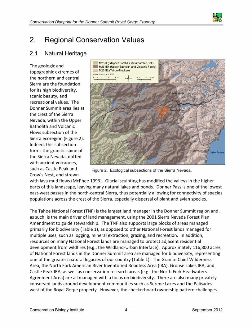
2.1 Natural Heritage The geologic and topographic extremes of the northern and central Sierra are the foundation for its high biodiversity, scenic beauty, and recreational values. The Donner Summit area lies at the crest of the Sierra Nevada, within the Upper Batholith and Volcanic Flows subsection of the Sierra ecoregion (Figure 2). Indeed, this subsection forms the granitic spine of the Sierra Nevada, dotted with ancient volcanoes, such as Castle Peak and Crow’s Nest, and strewn with lava mud flows (McPhee 1993). Glacial sculpting has modified the valleys in the higher parts of this landscape, leaving many natural lakes and ponds. Donner Pass is one of the lowest east-west passes in the north-central Sierra, thus potentially allowing for connectivity of species populations across the crest of the Sierra, especially dispersal of plant and avian species. The Tahoe National Forest (TNF) is the largest land manager in the Donner Summit region and, as such, is the main driver of land management, using the 2001 Sierra Nevada Forest Plan Amendment to guide stewardship. The TNF also supports large blocks of areas managed primarily for biodiversity (Table 1), as opposed to other National Forest lands managed for multiple uses, such as logging, mineral extraction, grazing, and recreation. In addition, resources on many National Forest lands are managed to protect adjacent residential development from wildfires (e.g., the Wildland-Urban Interface). Approximately 116,800 acres of National Forest lands in the Donner Summit area are managed for biodiversity, representing one of the greatest natural legacies of our country (Table 1). The Granite Chief Wilderness Area, the North Fork American River Inventoried Roadless Area (IRA), Grouse Lakes IRA, and Castle Peak IRA, as well as conservation research areas (e.g., the North Fork Headwaters Agreement Area) are all managed with a focus on biodiversity. There are also many privately conserved lands around development communities such as Serene Lakes and the Palisades west of the Royal Gorge property. However, the checkerboard ownership pattern challenges
Figure 2. Ecological subsections of the Sierra Nevada.

Conservation Blueprint for the Donner Summit Royal Gorge Property
Conservation Biology Institute 5 September 2012
the effectiveness of regional land management by allowing private lands to be managed differently, and at times incompatibly, with regional resource values on adjacent public lands (Figure 3). Table 1. America’s legacy of conserved lands in the Donner Summit area of the Sierra Nevada.
Designation Rule Definition
Inventoried Roadless Areas (IRA) Roadless Rule of 2001 Lands without existing roads that could be suitable for
wilderness conservation
Wilderness Areas 1964 Wilderness Act Lands without roads or development, conserved to protect natural processes, watersheds, and recreation
Wild and Scenic Rivers 1968 Wild and Scenic Rivers Act
Free-flowing reaches of rivers that possess at least one outstandingly remarkable value, such as scenic, recreational, geologic, fish, wildlife, historic, cultural, etc.
Research Natural Areas
2006 Agreement between TNF, research stations, and private landowners
Lands that maintain biological diversity, support research, and provide natural history education.
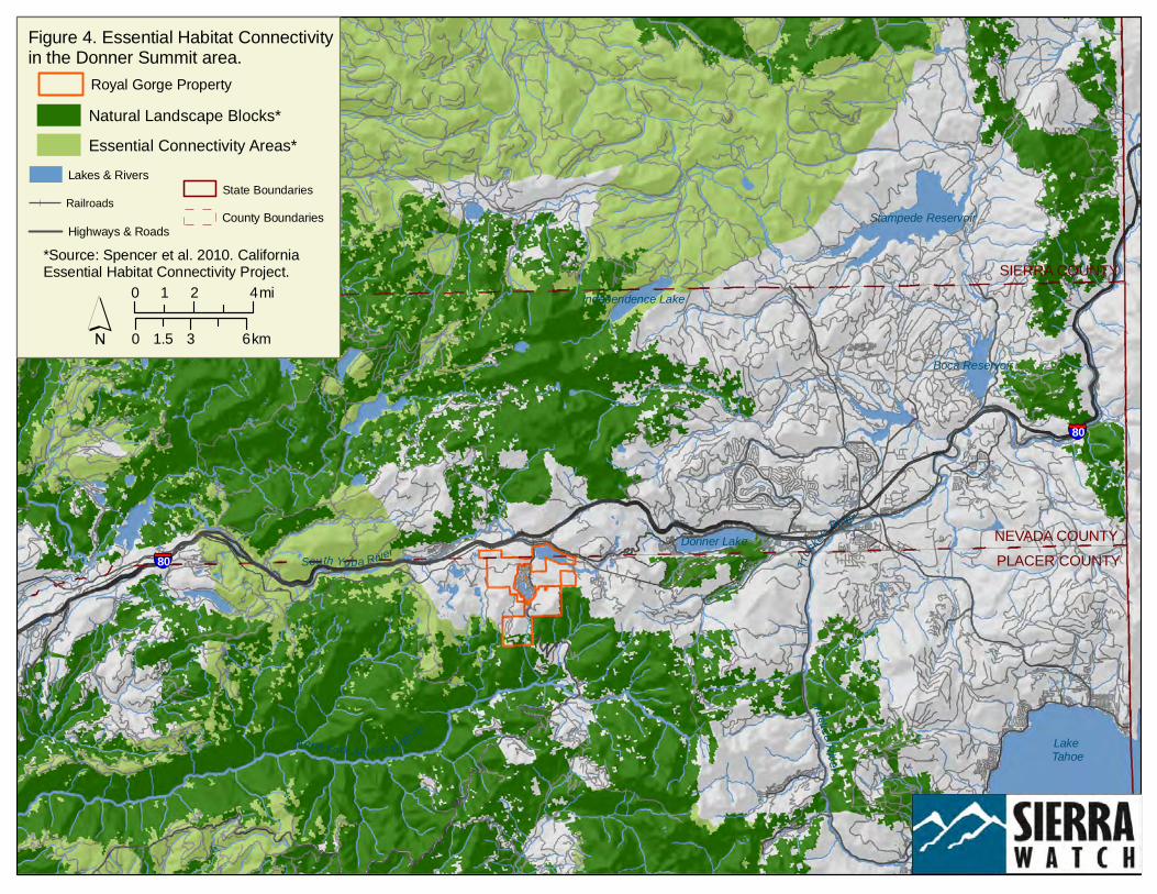
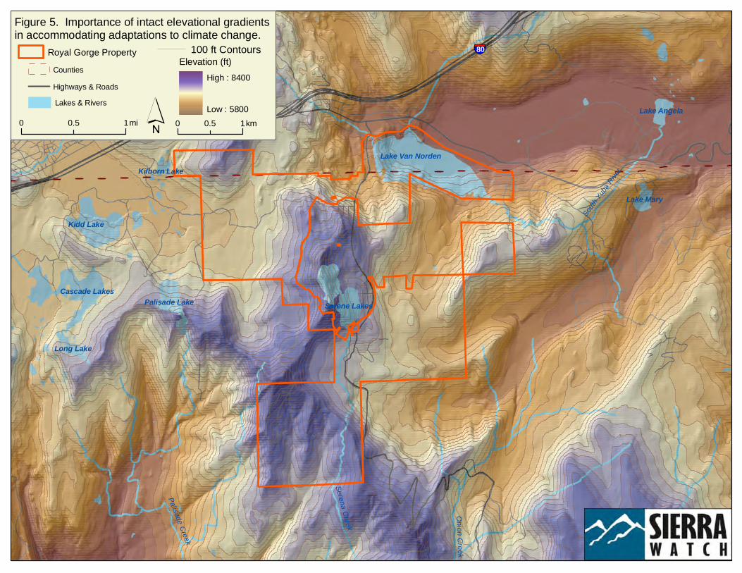
The Royal Gorge property, ranging from 6,500 to 8,000 ft, sits strategically between conserved areas protected and managed for their biodiversity, adding to the landscape-scale connectivity between existing conservation. In fact, conservation of the Royal Gorge property would add to the landscape currently identified as a Natural Landscape Block by the California Essential Habitat Connectivity Project (Figure 4, Spencer et al. 2010) and contribute to carnivore connectivity in the Tahoe and Eldorado National Forests and Lake Tahoe Basin Management Unit (Britting et al. 2012). Maintaining landscape-scale connectivity, north-south and east west, as well as linking alpine communities with downslope ecosystems, is critical for maintaining functional food chains and diverse ecological communities as well as for maintaining dynamic populations, dispersal, and gene flow for neotropical migratory birds, spotted owl, and wide-ranging species such as mountain lion and other carnivores, black bear, and mule deer. Moreover, conservation in this part of the Sierra spans dramatic elevational gradients important in allowing shifts in species distributions in response to climate change (Figure 5). This network of conserved lands is part of the Sierra’s essential infrastructure, providing services on which our economic, social, cultural, and political systems depend. Chan and colleagues (2006) demonstrate the overlap between protecting biodiversity and conserving ecosystem services, such as water quality and water supply, carbon sequestration, provisioning of forest products, and recreation. Biodiversity and ecosystem services are maintained by dynamic processes that function across very large landscapes, including disturbances from fire, floods, transport of organic and inorganic materials, and fluvial erosion and deposition, as well as nutrient and energy flow through food webs, population dynamics, gene flow, and species interactions such as predation and competition. Like any infrastructure, the conservation network needs continual investment in its foundation, as well as regular management and monitoring to ensure it is functioning effectively.

Truck
ee River
North Fork American River
South Yuba River
North Yuba R iver
Truckee River
Lake Tahoe
Stampede Reservoir
Donner Lake
Boca Reservoir
Independence Lake
TOIYABENATIONAL
FOREST
Donner MemorialState Park
§̈¦80
TAHOE NATIONAL
FOREST
TAHOE NATIONAL
FOREST
§̈¦80
TAHOE NATIONAL
FOREST
Granite ChiefWilderness
Area
Castle PeakIRAGrouse
LakesIRA
North ForkAmerican River
IRA
PLACER COUNTYNEVADA COUNTY
SIERRA COUNTY
Highways & RoadsRailroads State Boundaries
County BoundariesLakes & Rivers
Royal Gorge Property
Figure 3. Location of the Royal Gorge property in the Donner Summit area of the north-central Sierra Nevada.
Lake Tahoe
Wilderness Areas, Inventoried Roadless Areas,and Conservation Research Areas*Other Forest Service and Protected Lands**
North Fork Headwaters
Agreement Area
Emigrant Trail PCT - Pacific Crest Trail
Sources:*USDA Forest Service 2008**Conservation Biology Institute 2010 ´
0 2 41 mi
0 3 61.5 km
Truck
ee River
North Fork American River
South Yuba River
North Yuba R iver
Truckee River
Lake Tahoe
Stampede Reservoir
Donner Lake
Boca Reservoir
Independence Lake
§̈¦80
§̈¦80
PLACER COUNTYNEVADA COUNTY
SIERRA COUNTY
Figure 4. Essential Habitat Connectivityin the Donner Summit area.
Royal Gorge Property
Lake Tahoe
Natural Landscape Blocks*Essential Connectivity Areas*
*Source: Spencer et al. 2010. California Essential Habitat Connectivity Project.
State BoundariesCounty Boundaries
Highways & RoadsRailroads
Lakes & Rivers
´0 2 41 mi
0 3 61.5 km
South
Yuba
River
Onion Creek
Serena Creek
Palisade Creek
South
Yuba
River
Lake Van Norden
Kidd Lake
Serene LakesCascade Lakes
Palisade Lake
Lake Mary
Lake Angela
Long Lake
Kilborn Lake
§̈¦80
Figure 5. Importance of intact elevational gradients in accommodating adaptations to climate change.
Royal Gorge Property 100 ft Contours
0 10.5 mi 0 10.5 km´
Elevation (ft)High : 8400
Low : 5800
Highways & RoadsCounties
Lakes & Rivers

Conservation Blueprint for the Donner Summit Royal Gorge Property
Conservation Biology Institute 9 September 2012
2.2 Biological Resources The Sierra Nevada ecological region is one of the most floristically diverse regions in North America, with habitats ranging from alpine meadows and crystalline lakes to rare old-growth forests, mixed conifer and hardwood forests, montane chaparral, grasslands and meadows, and riparian communities along streams and in broader valleys (Figure 6). White fir, red fir, and lodgepole pine comprise half of the Royal Gorge property (Table 2, Appendix A). Lodgepole pines are the dominant trees in moist areas along meadows, as well as rocky areas, while the other conifers are typically found on deeper well-drained soils. These forest communities provide nesting and roosting sites for birds, cover and shelter, and food sources for a diversity of animals. The downed logs and woody debris support insects and smaller mammals that are
a source of food for larger animals, and snags of dead trees provide nesting cavities for owls and woodpeckers. Montane chaparral and small patches of juniper woodland are embedded within the conifer forests, particularly in the southern areas of the property on the granitic outcrops overlooking the Royal Gorge of the North Fork American River (NFA 2006a). Serena Creek flows south from Serene Lakes through a steep canyon to the American River. This diversity of vegetation communities, wetlands and perennial water, and elevational gradients, in turn, supports a diverse flora and fauna, including more than 80 special status animals and plants (Appendices B-1 and B-2). The Royal Gorge property has the potential to support more than 200 species of vascular plants (Appendix B-3), 13 species of amphibians and reptiles, 20 species of mammals, and over 100 species of birds (Appendix B-4).
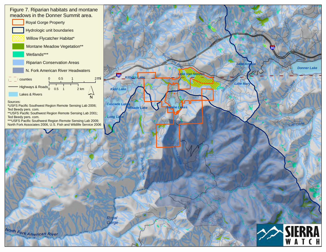
Wetlands
Montane Meadows and Riparian Conservation Areas designated by the USFS are abundant on the Royal Gorge property (Figure 7, Appendix A). North Fork Associates conducted wetland delineations over the Royal Gorge property and described seven wetland types (Table 3, NFA 2006b). These habitats comprise 9% of the Royal Gorge property, adding immensely to its overall species richness and wildlife habitat values.
Table 2. Vegetation communities of the Royal Gorge property.
Vegetation Community Acres % of site
Barren/rock outcrops 66.6 2.3%
Montane chaparral 185.0 6.5%
Sierran mixed conifer 805.7 28.4%
Lodgepole pine 363.7 12.8%
Jeffrey pine 3.2 0.1%
Red fir 952.1 33.6%
White fir 83.1 2.9%
Montane hardwood-conifer 7.6 0.3%
Montane riparian 5.2 0.2%
Grassland (dry meadow) 67.3 2.4%
Wet meadow* 246.7 8.7%
Lacustrine 48.8 1.7%
Urban 18.2 0.6%
Total 2,835.2 100%
*includes montane wetland scrub, seasonal marsh, and wetland swale.

Lake Van Norden
Kidd Lake
Serene LakesCascade Lakes
Palisade Lake
Lake Mary
Lake Angela
Long Lake
Kilborn Lake
§̈¦80
§̈¦80
Figure 6. Diversity of vegetation communities on the Royal Gorgeproperty.
Vegetation Community*
countiesHighways & RoadsLakes and Rivers
Wet MeadowMontane ChaparralSierran Mixed ConiferWhite FirRed FirLodgepole PineBarrenLacustrine
Grasslands
*Sources: USFS Pacific Southwest Region Remote Sensing Lab 2009; North Fork Associates 2006, U.S. Fish and Wildlife Service 2006; USGS GAP Program 2008.
Royal Gorge Property
´0 10.5 mi
0 10.5 km
Developed
South Yuba River
Cold Creek
Palisade Creek
Onion Creek
Serena Creek
Donner C
reek
South Y
uba River
North Fork American River
Donner LakeLake Van Norden
Kidd Lake
Serene LakesCascade Lakes
Palisade Lake
Lake Mary
Lake Angela
Long Lake
Kilborn Lake§̈¦80
§̈¦80
countiesHighways & RoadsLakes & Rivers
Figure 7. Riparian habitats and montane meadows in the Donner Summit area.
RoyalGorge
Royal Gorge Property
Riparian Conservation Areas
Montane Meadow Vegetation**Willow Flycatcher Habitat*Hydrologic unit boundaries
N. Fork American River Headwaters
Wetlands***
Sources:*USFS Pacific Southwest Region Remote Sensing Lab 2006; Ted Beedy pers. com.**USFS Pacific Southwest Region Remote Sensing Lab 2001; Ted Beedy pers. com.***USFS Pacific Southwest Region Remote Sensing Lab 2009; North Fork Associates 2006, U.S. Fish and Wildlife Service 2006
0 1 20.5 mi
0 1 20.5 km ´
Conservation Blueprint for the Donner Summit Royal Gorge Property
Conservation Biology Institute 12 September 2012
Lake Van Norden was created originally by damming the headwaters of the South Yuba River about 100 years ago. The dam was breached in 1972 (Beedy and Brussard 2002, Jones & Stokes 2004), and it now consists of a notched concrete spillway that holds water in the reservoir at a depth of less than 10 ft (NFA 2006b). Also known as Summit Valley, it supports one of the largest wetlands in the Sierra, covering over 200 acres of lacustrine and wet meadow habitat, with emergent vegetation around its shores. Migratory waterfowl, songbirds, wading birds, and shore birds use the lake and its willow-lined shoreline as wintering areas or temporary stopover resting and foraging sites during migration. The lake has been stocked with a variety of nonnative fish that support recreational fishing and provide prey for predatory birds such as bald eagles and ospreys (T. Beedy pers. comm.). Wet, mesic, and dry meadow systems network throughout the Royal Gorge property (Figure 7, NFA 2006b). These montane meadows are keystones of the Sierra Nevada ecosystem. They reduce peak water flow after storms and during runoff, recharge groundwater supplies as they release water into the ground, filter sediments, and provide food and shelter for a variety of wildlife including special status species like willow flycatchers and Sierra Nevada yellow-legged frogs. Management Indicator Species
The 2001 Sierra Nevada Framework Plan required that the U.S. Forest Service (USFS) focus management on improving habitat conditions for and develop a monitoring program for keystone and important wildlife species−Management Indicator Species−within the National Forests of the Sierra Nevada. Management Indicator Species for the Tahoe National Forest include the Sierra Nevada yellow-legged frog, bald eagle, California spotted owl, northern goshawk, willow flycatcher, Pacific marten1, Sierra Nevada red fox, wolverine, and mule deer, included here as potential conservation targets for management planning on the Royal Gorge property. Sierra Nevada Yellow-Legged Frog. Once the most abundant frog in the Sierra Nevada, 94% of historical populations of yellow-legged frog are now extirpated (CDFG 2011), primarily due to pesticides, disease, and predation by nonnative trout stocked in high elevation lakes that historically did not contain fish (Davidson and Knapp 2007). This amphibian is adapted to the cold temperatures of glaciated lakes above 6,000 ft; tadpoles typically require 2-3 summers before metamorphosing and thus must overwinter. The Sierra Nevada Framework Plan (USFS
1 Taxonomic review has identified martens west of the Rocky Mountain crest as a separate species (Pacific marten,
Martes caurina) from those to the east (Martes americana) (Dawson and Cook In press).
Table 3. Wetland habitats on the Royal Gorge property.
Type Acres
Wet meadow 163.7 Montane wetland scrub* 6.7 Seasonal marsh* 1.9 Wetland swale* 2.3 Intermittent stream 13.5 Ephemeral stream 5.0 Open water 63.5
Total 256.5
Source: NFA 2006b *Combined on Figure 7 as wet meadow.
Conservation Blueprint for the Donner Summit Royal Gorge Property
Conservation Biology Institute 13 September 2012
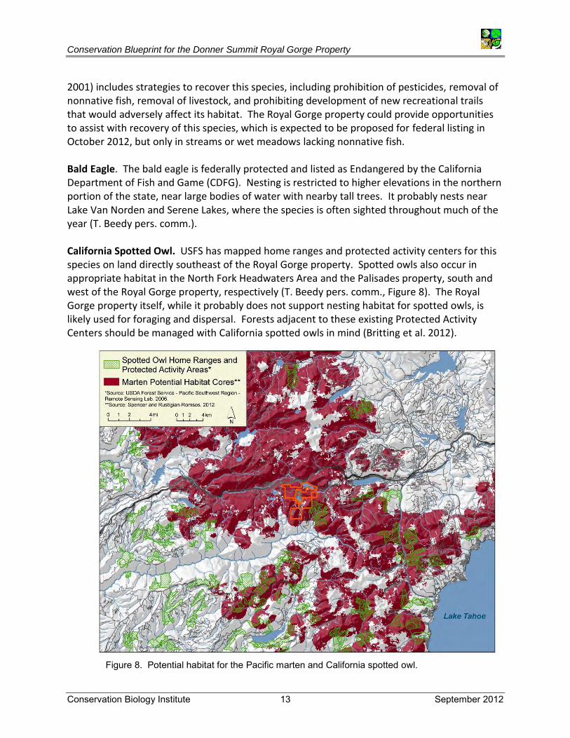
2001) includes strategies to recover this species, including prohibition of pesticides, removal of nonnative fish, removal of livestock, and prohibiting development of new recreational trails that would adversely affect its habitat. The Royal Gorge property could provide opportunities to assist with recovery of this species, which is expected to be proposed for federal listing in October 2012, but only in streams or wet meadows lacking nonnative fish. Bald Eagle. The bald eagle is federally protected and listed as Endangered by the California Department of Fish and Game (CDFG). Nesting is restricted to higher elevations in the northern portion of the state, near large bodies of water with nearby tall trees. It probably nests near Lake Van Norden and Serene Lakes, where the species is often sighted throughout much of the year (T. Beedy pers. comm.). California Spotted Owl. USFS has mapped home ranges and protected activity centers for this species on land directly southeast of the Royal Gorge property. Spotted owls also occur in appropriate habitat in the North Fork Headwaters Area and the Palisades property, south and west of the Royal Gorge property, respectively (T. Beedy pers. comm., Figure 8). The Royal Gorge property itself, while it probably does not support nesting habitat for spotted owls, is likely used for foraging and dispersal. Forests adjacent to these existing Protected Activity Centers should be managed with California spotted owls in mind (Britting et al. 2012).
Figure 8. Potential habitat for the Pacific marten and California spotted owl.

Conservation Blueprint for the Donner Summit Royal Gorge Property
Conservation Biology Institute 14 September 2012
Northern Goshawk. Like spotted owls, goshawks prefer dense, mature forests for nesting, especially those near ponds, creeks, or ephemeral streams. Northern goshawks are known from the Palisades property due west of Royal Gorge, and also use the Royal Gorge property (Beedy and Chainey-Davis 2008, Beedy pers. comm.). There is suitable nesting habitat throughout the property, particularly on north-facing slopes in the vicinity of Lake Van Norden, South Yuba River, and near Serene Lakes (NFA 2006a). According to the USFS management guidelines, the nest area for one pair is approximately 30 acres, while its foraging area ranges across 5,400 acres (Reynolds et al. 1992). Willow Flycatcher. According to the USFS, the Sierra subspecies of the willow flycatcher has the highest priority for conservation because of its high potential for extirpation from the Sierra Nevada. Willow flycatcher populations have declined precipitously in the Sierra Nevada since the mid-20th century, largely due to habitat loss and degradation of meadow habitats and nest parasitism by brown-headed cowbirds, which are often attracted by livestock grazing. The dense stands of willows and wet meadows upstream of Lake Van Norden support a thriving breeding population of willow flycatchers, a state-listed Endangered Species (Figure 7, Beedy and Brussard 2002, Beedy and Chainey-Davis 2008, Beedy and Pandolfino in press). Pacific Marten. Martens are strongly associated with high-elevation forests, especially unmanaged red fir forests (Spencer and Rustigian-Romsos 2012), and riparian areas near mature forests are important for foraging (Spencer et al. 1983). Therefore, maintaining and improving connectivity of mature forests is a key conservation objective for managing martens in this region. CBI has identified potential summer habitat for this species across much of the Donner Summit region (Figure 8, Appendix A), and martens have been sighted in the Headwaters of the North Fork American River, south of the Royal Gorge property, and on the Palisades property, west of the Royal Gorge property (Beedy pers. comm., Beedy and Chainey-Davis 2008). Although much of marten core habitat is within national parks and wilderness areas, significant portions are on USFS multiple-use lands subject to timber harvest and other vegetation treatments, which can fragment habitat and reduce or eliminate use by martens (Slauson and Zielinski 2008, Moriarty et al. 2011). Also, ski area development fragments marten habitat, reducing local marten populations due to avoidance of smaller fragments (especially by females) and decreased survival and reproduction within larger fragments (K. Slauson, unpublished data). Increases in housing development, roads, and ski areas could isolate martens, and extensive vegetation treatments on USFS lands, or large, severe wildfires, could potentially fragment marten populations. Thus, conserving the Royal Gorge property without these multiple land uses will contribute to marten persistence in the area. However, I-80 and Old Highway 40 are significant barriers to carnivore movement in the Donner Summit area (Spencer and Rustigian-Romsos 2012). Sierra Nevada Red Fox. This subspecies of the red fox is listed as Threatened by the CDFG. It almost certainly occurred in the Donner Summit area historically but is considered locally extirpated. Schempf and White (1977) show 2-5 observations near the Truckee River and Sierra/Nevada County line from 1960-1974. Very recently, at least two red foxes were detected
Conservation Blueprint for the Donner Summit Royal Gorge Property
Conservation Biology Institute 15 September 2012
by remote camera and scats near Sonora Pass in the southern Sierra Nevada (just northeast of Yosemite National Park on the Humboldt-Toiyabe and Stanislaus National Forests). CBI has delineated potentially suitable habitat and assessed habitat connectivity needs for the species in the Sierra Nevada (Spencer and Rustigian-Romsos 2012, Appendix A), suggesting that, with appropriate management across its range, the more undisturbed portions of the Donner Summit area could provide suitable habitat for this rare and secretive species in the future. Wolverine. Wolverines are considered functionally extirpated from California; however, the National Park Service is seriously considering reintroducing wolverines to National Parks in the southern Sierra (D. Graber pers. comm.), and Britting and others (2012) recommend that USFS Region 5 develop a management plan for monitoring and conservation of this species. A single male wolverine recently dispersed to the northern Sierra Nevada (north of the Royal Gorge property), probably from the Sawtooth Range in Idaho (Moriarity et al. 2009). Based on numerous sightings, this individual has established a home range north from the vicinity of Sagehen Creek (Spencer and Rustigian-Romsos 2012). Although wolverines are very strong dispersers, capable of traversing hundreds of miles, human modifications such as highways and urban areas decrease the probability of a wolverine surviving as it moves across the landscape. Identifying and protecting likely dispersal routes is therefore a high conservation priority. Although the Royal Gorge property lies within the historic range of wolverines, and recent research has identified this area as potentially suitable core habitat (Appendix A, Spencer and Rustigian-Romsos 2012), the presence of highways and human recreational activity make it unlikely that the Royal Gorge property would be used by wolverines other than for dispersal. Mule Deer. The Royal Gorge property lies roughly at the intersection of three mule deer herds: the Loyalton-Truckee herd east of the property, the Nevada City herd in Nevada County on the north edge of the property, and the Blue Canyon herd of both migratory and resident deer that remains south of I-80 in eastern
Figure 9. Sierra Nevada mule deer herds in the Donner Summit area.
Conservation Blueprint for the Donner Summit Royal Gorge Property
Conservation Biology Institute 16 September 2012
Placer County (CDFG Region 2, Figure 9). The Blue Canyon herd includes three sub-species: the Columbian black-tailed deer, California mule deer, and Rocky Mountain mule deer (Fowler and Wagner 1982). The first heavy snows typically trigger fall migration, with major seasonal movement corridors documented to the north of Foresthill Divide and to the south along the Middle Fork of the American River. The Royal Gorge property occurs within the known summer range, and wet meadows on the property could support fawning areas for mule deer. The Blue Canyon deer herd plan (Fowler and Wagner 1982), although dated, cites the checkerboard pattern of land ownership over much of its range as a challenge to consistent habitat management. One of the cited objectives of the plan is for the CDFG to work cooperatively with the USFS and private land owners to fund and perform habitat alterations at selected sites, concentrating on key winter ranges and fawning habitats, while limiting residential development and roads, which are not compatible with forage and cover requirements for deer. Royal Gorge could qualify as one of these deer management sites.
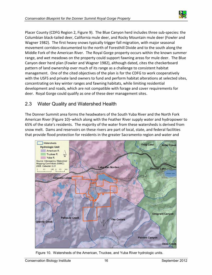
2.3 Water Quality and Watershed Health The Donner Summit area forms the headwaters of the South Yuba River and the North Fork American River (Figure 10)−which along with the Feather River supply water and hydropower to 65% of the state’s residents. The majority of the water from these watersheds is derived from snow melt. Dams and reservoirs on these rivers are part of local, state, and federal facilities that provide flood protection for residents in the greater Sacramento region and water and
Figure 10. Watersheds of the American, Truckee, and Yuba River hydrologic units.
Conservation Blueprint for the Donner Summit Royal Gorge Property
Conservation Biology Institute 17 September 2012
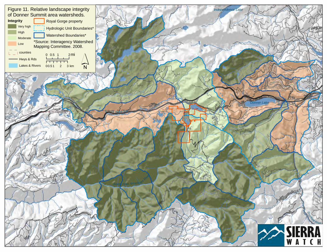
power for urban and agricultural users throughout the Central Valley. Intact watersheds are important for maintaining adequate supplies of clean runoff and for providing land managers with greater flexibility to optimize watershed management actions and reservoir operations, thus achieving biological objectives, securing water supplies, and maintaining power generation capacity. These river systems also sustain diverse aquatic and terrestrial flora and fauna (e.g., Wright et al. 2004), which depend on natural hydrological cycles to replenish nutrients, create openings, and recruit individuals into riparian vegetation communities. Approximately 54% of the Royal Gorge property is in the American River watershed, with 46% in the Yuba River watershed. The ridge between Lake Van Norden and Serene Lakes forms the divide between these watersheds. South of this divide water flows into Onion Creek, Serena Creek, and Palisade Creek, which are tributaries of the North Fork of the American River. These river systems are also focal points for human recreation. TPL’s Sierra Nevada Checkerboard Initiative targets the upper watershed of the North Fork American River as the largest of five high quality resource areas (White et al. 2005, 2009). The North Fork has been federally designated as Wild and Scenic and supports a USFS Inventoried Roadless Area that has been proposed as a Wilderness Area. The Checkerboard Initiative targets the South Yuba River as one of five river corridors that support human recreation, scenic beauty, and human water supplies. Reaches of the South Yuba River are designated as Wild and Scenic and associated with hiking on the South Yuba Trail, water rafting, and fishing. The Checkerboard Initiative proposes conservation objectives for these resource areas that are complementary to protecting recreational and visual resources as well as buffering and connecting existing and proposed Wilderness Areas, with an emphasis on maintaining natural ecosystem processes by preventing new development, road-building, and large-scale timber plantations. Watershed basins are good units for conservation analyses because they integrate conditions over relatively large areas and support geographically distinct ecological processes, dependent on their position in the landscape. Because individual watershed basins have varying topography and geology, they support mosaics of forest community composition and structure and thus can serve as useful units for framing landscape-scale forest conservation objectives (White et al. 2005, 2009). Loss of natural vegetative cover and attendant increases in impervious surface cover, as a result of development, can adversely affect natural flow regimes, sediment dynamics, and riparian habitat quality. We measured watershed integrity in the Donner Summit area, using watershed sub-basins (hydrologic subareas) as the analytical unit. In this analysis, we calculated and ranked the area of land cover change for each watershed sub-basin, with higher integrity basins having lower levels of land cover change. Figure 11 shows how watershed integrity has been compromised along I-80 and in areas supporting housing and associated roads. Areas without roads, such as the southern portions of the Royal Gorge property, have the highest watershed integrity, and new roads or development activities should be prohibited in this part of the property.
North Fork American River
South Yuba River
Truckee River
Donner Lake
Independence LakeFigure 11. Relative landscape integrity of Donner Summit area watersheds.Integrity
Very highHIghModerateLow *Source: Interagency Watershed
Mapping Committee. 2008.
Royal Gorge propertyHydrologic Unit Boundaries*Watershed Boundaries*
counties
Lakes & RiversHwys & Rds
0 1 20.5 mi
0 1 2 30.5 km ´

Conservation Blueprint for the Donner Summit Royal Gorge Property
Conservation Biology Institute 19 September 2012
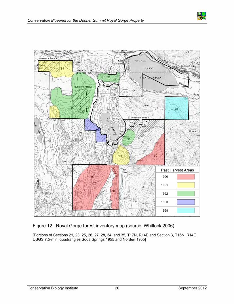
2.4 Forests Due to historic forest management practices, mature forests are under-represented in the Sierra Nevada (Franklin and Fites-Kaufmann 1996). Thus, conservation and management for mature forest values has become a regional conservation priority. TPL’s Sierra Checkerboard Initiative identifies the Yuba and American rivers as two of four resource areas emphasizing mature forests, and the Sierra Nevada Ecosystem Project (SNEP) (Franklin and Fites-Kaufmann 1996) also ranked the Donner Summit region as contributing to mature forest functions. Logging in this area dates back to the railroad era (1860s). Kevin Whitlock, a registered forester, conducted an inventory of the Royal Gorge property in 2006 (Figure 12), showing that most of the accessible areas were last harvested in the 1990s, resulting in maturing, even-aged forests (category 2, Table 4). While the Royal Gorge property itself does not support significant stands of mature forests, surrounding areas such as the Onion Creek Experimental Forest and the North Fork Headwaters Area lie within a USFS-designated Area of Late Successional Emphasis. Therefore, long-term stewardship goals for the property should include management for mature forest characteristics (i.e., a mosaic of stands with large-diameter trees, snags, and down logs), particularly in areas adjacent to Onion Creek Experimental Forest and the North Fork Headwaters Area. The desired condition for future management should be to achieve stands with rankings 4 and 5 (K. Whitlock pers. comm.).
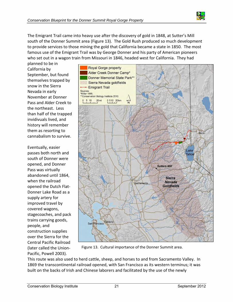
2.5 Cultural Importance The history of the Donner Summit area is synonymous with that of California and colonization of the West. The 88-mile Emigrant Trail, dating from 1841, opened up California not only to Americans from the rest of the U.S., but also to people from abroad. This overland wagon trail, which crossed the historic Donner Pass, at 7,085 ft, is one of the lowest elevation passes in the Sierra Nevada. This route across the Royal Gorge property was a major pre-historic trade route for Native Americans. The Donner Summit area was the summer home of the Martis tribe, hunter-gatherers named after arrow points found in the Martis Valley near Truckee. They have left their imprints behind in the form of petroglyphs and bedrock mortars throughout the Donner Summit area (Powell 2003).
Table 4. USFS rankings.
1. Structurally simple forests, such as young plantations, areas recently burned and salvaged
2. Maturing even-aged forests lacking large-diameter trees, snags, and logs
3. Selectively logged or burned areas that retained significant numbers of large trees and snags or second-growth forests approaching maturity
4. Old growth mixed conifer forests with open, park-like structures often produced by frequent low-intensity fire
5. Forests with the highest levels of structural complexity, including many large trees
(Source: USFS 1996 Table 115 - Sierra Nevada Old Growth Significance)
Conservation Blueprint for the Donner Summit Royal Gorge Property
Conservation Biology Institute 20 September 2012
Figure 12. Royal Gorge forest inventory map (source: Whitlock 2006).
[Portions of Sections 21, 23, 25, 26, 27, 28, 34, and 35, T17N, R14E and Section 3, T16N, R14E USGS 7.5-min. quadrangles Soda Springs 1955 and Norden 1955]
Past Harvest Areas 1990 1991 1992 1993 1998
Conservation Blueprint for the Donner Summit Royal Gorge Property
Conservation Biology Institute 21 September 2012
The Emigrant Trail came into heavy use after the discovery of gold in 1848, at Sutter’s Mill south of the Donner Summit area (Figure 13). The Gold Rush produced so much development to provide services to those mining the gold that California became a state in 1850. The most famous use of the Emigrant Trail was by George Donner and his party of American pioneers who set out in a wagon train from Missouri in 1846, headed west for California. They had planned to be in California by September, but found themselves trapped by snow in the Sierra Nevada in early November at Donner Pass and Alder Creek to the northeast. Less than half of the trapped invidivuals lived, and history will remember them as resorting to cannabalism to survive. Eventually, easier passes both north and south of Donner were opened, and Donner Pass was virtually abandoned until 1864, when the railroad opened the Dutch Flat-Donner Lake Road as a supply artery for improved travel by covered wagons, stagecoaches, and pack trains carrying goods, people, and construction supplies over the Sierra for the Central Pacific Railroad (later called the Union-Pacific, Powell 2003). This route was also used to herd cattle, sheep, and horses to and from Sacramento Valley. In 1869 the transcontinental railroad opened, with San Francisco as its western terminus; it was built on the backs of Irish and Chinese laborers and facilitated by the use of the newly
Figure 13. Cultural importance of the Donner Summit area.
Conservation Blueprint for the Donner Summit Royal Gorge Property
Conservation Biology Institute 22 September 2012
discovered explosive nitroglycerine. Eventually, this trade route became the location of the first continental roadway−Highway 40−also called the Lincoln Highway, eventually becoming part of the interstate highway system (I-80) in 1960. The Donner Memorial State Park, Emigrant Trail Museum, Pioneer Monument, and the new High Sierra Crossing Museum were established to commemorate the site of the ill-fated Donner Party, and the history of the Donner Pass itself, as well as to showcase the extraordinary geologic history of the Sierra, its natural resources, Native American history, and the history of railroad development through Donner Pass. The Alder Creek Donner Camp northeast of the Royal Gorge property is a National Historic Landmark (Figure 13).
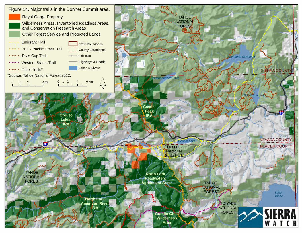
2.6 Sierra Recreation The topographic extremes in the Donner Summit area produce some of the most dramatic views in the Sierra, ranging from peaks over 9,000 ft elevation down to river gorges below 4,000 ft. This most iconic of California landscapes is a readily accessible recreation destination for millions of Californians. Recreational opportunities include hiking, camping, fishing, skiing, biking, equestrian activities, and nature study. The extensive trail system traversing this part of the Sierra includes the well-known Pacific Crest and Emigrant trails, as well as the Rubicon Trail, South Yuba Trail, Tevis Cup/Western States Trail, Palisades Creek Trail, Cascade Lake OHV, Mt. Judah Loop, Summit Lake Trail, the Truckee Donner Land Trust’s Donner Rim Trail, and others (selected trails shown on Figure 14). Conservation of the Royal Gorge property will allow consolidated management of recreational trail use, compatible with resource protection goals. Downhill skiing in North America began in the gold fields of the Sierra in the early 1850s, and construction of the railroad played an important role in development of the ski industry on Donner Summit (Powell 2003). The Sugar Bowl Corporation was founded in 1938, and the second chair lift in the country, to the top of Mt. Disney, was installed at Sugar Bowl in 1939. Walt Disney was one of Sugar Bowl’s original investors. The Royal Gorge cross-country ski trails were opened in 1971 and today represent the largest cross-country ski area in the U.S., with over 200 miles of maintained trails (Powell 2003). The Sierra Checkerboard initiative emphasizes conservation of recreational and visual resources in the Donner Summit area, with a focus on areas bordering the Grouse Lakes proposed wilderness area, the Granite Chief Wilderness Area, and Independence Lake.
Truck
ee River
North Fork American River
South Yuba River
North Yuba R iver
Truckee River
Lake Tahoe
Stampede Reservoir
Donner Lake
Boca Reservoir
Independence Lake
TOIYABENATIONAL
FOREST
Donner MemorialState Park
§̈¦80
TAHOE NATIONAL
FOREST
TAHOE NATIONAL
FOREST
§̈¦80
TAHOE NATIONAL
FOREST
Granite ChiefWilderness
Area
Castle PeakIRAGrouse
LakesIRA
North ForkAmerican River
IRA
PLACER COUNTYNEVADA COUNTY
SIERRA COUNTY
Figure 14. Major trails in the Donner Summit area.
Lake Tahoe
North Fork Headwaters
Agreement Area
Royal Gorge PropertyWilderness Areas, Inventoried Roadless Areas,and Conservation Research AreasOther Forest Service and Protected Lands
Highways & RoadsRailroads
State BoundariesCounty Boundaries
Lakes & Rivers
PCT - Pacific Crest TrailTevis Cup TrailWestern States TrailOther Trails*
Emigrant Trail
*Source: Tahoe National Forest 2012.0 2 41 mi 0 2 4 61 km ´
Conservation Blueprint for the Donner Summit Royal Gorge Property
Conservation Biology Institute 24 September 2012
3. Threats and Vulnerability In 2005 developers purchased Royal Gorge’s almost 3,000 acres and proposed a massive development comprising 950 new residential units, new ski lifts, equestrian facilities, and over 85,000 square ft of various commercial buildings. Such a large development would have brought thousands of new residents and recreational visitors to the Donner Summit area. Removing the threat of inappropriate development from the Royal Gorge property will ensure that habitat on the property remains intact, management for biodiversity can be coordinated among conservation partners, ecosystem processes remain intact so that the area is more resilient to changes in climate, and water quality and water supply are managed as an ecosystem service. This section emphasizes the threats that remain and the importance of regional management and vigilance in abating and mitigating these threats. Because the conservation values are so inextricably linked, any impacts to one of them will have cascading effects on the others.
3.1 Habitat Loss and Fragmentation The principal causes of species endangerment are the loss and degradation of habitat, fragmentation of remaining habitat areas into smaller, more isolated blocks, and edge effects that permeate the remaining habitat. Roads and increased residential densities put more pressure on native habitat as a recreational resource, often leading to inappropriate uses. Fragmentation also disrupts interactions among species, for example, between plants and their pollinators, plants and their dispersers, plants and their herbivores, predators and their prey. Fragments are more susceptible to invasive plant and animal species, including pathogens and their hosts. A break in the food web or a change in population dynamics can have cascading and compounding consequences that result in ecological collapse of the community. Although fire has always been an important ecological process in the Sierra Nevada, catastrophic fires can burn larger contiguous areas at higher intensities than is typical under historic fire regimes, and they release large amounts of carbon into the atmosphere. Catastrophic wildfires can cause severe ecological damage by consuming larger trees, sterilizing and mineralizing soils, and prolonging normal recovery time. Conversely, development in and adjacent to wildlands forces fire managers to be more aggressive in protecting human lives and property than would otherwise be required by allowing more natural fire regimes.
3.2 Climate Change The Sierra Nevada has been identified as one of ten ecosystems in the U.S. where climate change impacts could have the greatest effects on Threatened, Endangered, and other special status species, and where intervention can have the most impact if we restore resilience to these ecosystems (Endangered Species Coalition 2011). Climate change will likely produce ecosystem-level changes in the Sierra Nevada, with significant implications to water supply and
Conservation Blueprint for the Donner Summit Royal Gorge Property
Conservation Biology Institute 25 September 2012
power generation systems dependent on Sierra rivers, as well as to species adapted to historic hydrologic regimes. There is already evidence of hydrologic alterations of river systems associated with warming. The loss of snowpack during warmer climates will further alter runoff patterns in streams and rivers, with a relatively greater proportion of stream flow likely to occur as a result of rain, rather than snow, in fall and winter, and relatively less rain in spring and summer than currently occurs. A shift in winter precipitation from snowfall to rainfall could also produce more flood events associated with individual winter storms rather than spring floods associated with snow melt. Nonetheless, there are several actions that can ameliorate the effects of climate change, and conservation and sustainable management of the Royal Gorge property can contribute to some of these by restoring structure and process to forest systems, including:
Reducing habitat fragmentation.
Limiting the disruption of ecological processes (e.g., hydrologic cycles) and allowing natural disturbance processes (e.g., fire).
Reducing human-induced habitat degradation.
Integrating science into management.
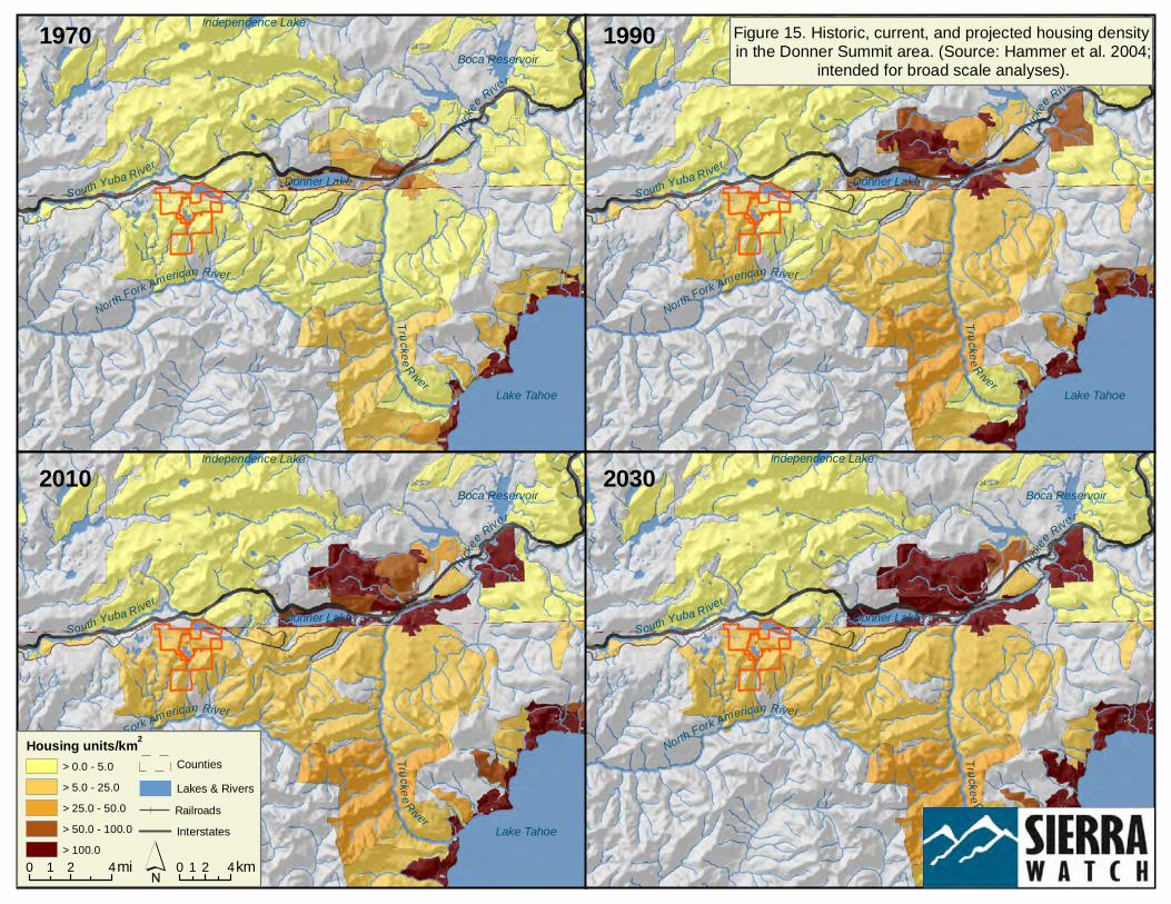
3.3 Effects of Regional Land Use Changes Population growth brings with it the corresponding need for open space and recreation areas, a larger strain on land management resources due to unauthorized uses (e.g., vandalism, arson, off-road vehicle use, and dumping), greater consumption of surface and groundwater in the region (e.g., by homes and golf courses), and the ever dwindling supply of land for siting housing and infrastructure for a growing population. Unauthorized uses of public and private lands have damaged property (e.g., gates and signs), eliminated habitat for rare species, caused erosion that eventually leads to sedimentation in drinking water, and introduced nonnative species that displace and destroy habitat of native species. Subdivision and rural residential development continue to expand in the region, particularly along major transportation corridors, such as I-80 and on privately-owned lands in larger, well-watered valleys (Figure 15). Private developments and land use changes in otherwise contiguous public lands pose conflicts in public access, land use, and management and limit the ability of public land managers to achieve natural resource conservation objectives that require landscape-scale management actions. For example, fire suppression in the Wildland-Urban Interface has had profound effects on conserved lands. The increasing demand for water resources by California’s cities, agriculture, and hydroelectric facilities also threatens the resource values of aquatic and wetland habitats of the Sierra. Land use changes, impoundments, and diversions alter riverine flow regimes and water quality. These, in turn, affect the structure of aquatic and riparian communities. Inappropriate

Conservation Blueprint for the Donner Summit Royal Gorge Property
Conservation Biology Institute 26 September 2012
management of forests, groundwater overdraft, and overgrazing of meadows are incompatible with biodiversity conservation objectives. Inappropriate development also constrains natural resources management options for the region. Conservation and socioeconomic challenges can be addressed only through a comprehensive, ecosystem-wide approach that integrates management of environmental resources with a sustainable tourism industry.
Trucke
e River
North Fork American River
South Yuba River
Truc k ee R iverLake Tahoe
Donner Lake
Boca Reservoir
Independence Lake
Est # housing units by 1989> 0 - 56 - 1011 - 2526 - 5051 - 100101 - 500501 - 10001001 - 5000
Trucke
e River
North Fork American River
South Yuba River
Truc k ee R iverLake Tahoe
Donner Lake
Boca Reservoir
Independence Lake
Trucke
e River
North Fork American River
South Yuba River
Tru ck ee RiverLake Tahoe
Donner Lake
Boca Reservoir
Independence Lake
Trucke
e River
North Fork American River
South Yuba River
Truc k ee R iverLake Tahoe
Donner Lake
Boca Reservoir
Independence Lake
1970 1990
20302010
Figure 15. Historic, current, and projected housing density in the Donner Summit area. (Source: Hammer et al. 2004;
intended for broad scale analyses).
Housing units/km2
> 5.0 - 25.0> 25.0 - 50.0> 50.0 - 100.0> 100.0
> 0.0 - 5.0
0 2 41 mi 0 2 41 km´RailroadsLakes & RiversCounties
Interstates
Conservation Blueprint for the Donner Summit Royal Gorge Property
Conservation Biology Institute 28 September 2012
4. Protecting Our Investments Californians have the privilege to enjoy and appreciate the conservation vision of our predecessors—our federal, state, locally, and privately protected lands. These privileges, however, are accompanied by very real obligations. We have the responsibility to sustain and enhance those investments in the face of recreational pressures and land use change. Existing public conservation investments—Wilderness Areas, Wild and Scenic Rivers, and Inventoried Roadless Areas—form the cornerstone for conserving north-south and east-west cross-sections of the north-central Sierra landscape. The integrity of the Donner Summit area is important also to ensure landscape connectivity between conserved lands in the northern Sierra (e.g., Lassen National Park, Feather River Land Trust) and conserved areas to the south (e.g., Yosemite National Park). Without additional conservation investment, this landscape is at risk of degradation from incompatible land uses. The stakeholders of the Donner Summit area have the potential to enhance core resource values through conservation and management of the Royal Gorge property and thereby further the return on investment in land acquisition, management, monitoring, and research previously established, as described below. The Onion Creek Experimental Forest, bordering the southeast portion of the Royal Gorge property (Figure 16), was established in 1958 to develop techniques for increasing water yields from forested lands in the Sierra Nevada snow zone. The facility is now managed by the University of California at Berkeley. Long-term climatic data have been monitored since 1976, and continuous stream discharge has been recorded from five hydrologic sub-basins. The Central Sierra Snow Lab at Norden and Sagehen Creek Field Station also conduct long-term studies in the area to inform resource management. Private conservation has also been important in the region. TPL has conserved almost 10,000 acres of private checkerboard lands in the Donner Summit area, as part of its Sierra Checkerboard Initiative. The Truckee Donner Land Trust, in partnership with TPL, has acquired over 2,100 acres of private lands adjacent to Donner Memorial State Park since 1995, making it one of the largest state parks in the Sierra. The Serene Lakes Property Owners Association (420 acres) and the 878-acre Palisades community (Figure 16) are invested in maintaining the intactness of the Donner Summit landscape, and the resorts in the area are interested in maintaining natural open space for cross-country skiing and other recreation. The 2006 Conservation and Research Agreement among the TNF, Pacific Southwest Research Station, University of California, North Fork Association, and the Chickering Partnership establishes a public-private partnership to (1) preserve the character of the North Fork American River headwaters basin, (2) facilitate coordinated research and management efforts on the lands subject to the agreement (19,670 acres), and (3) facilitate communication among the parties. The goals of the agreement are consistent with the TNF Plan and represent an excellent example of collaborative landscape-scale management and monitoring.
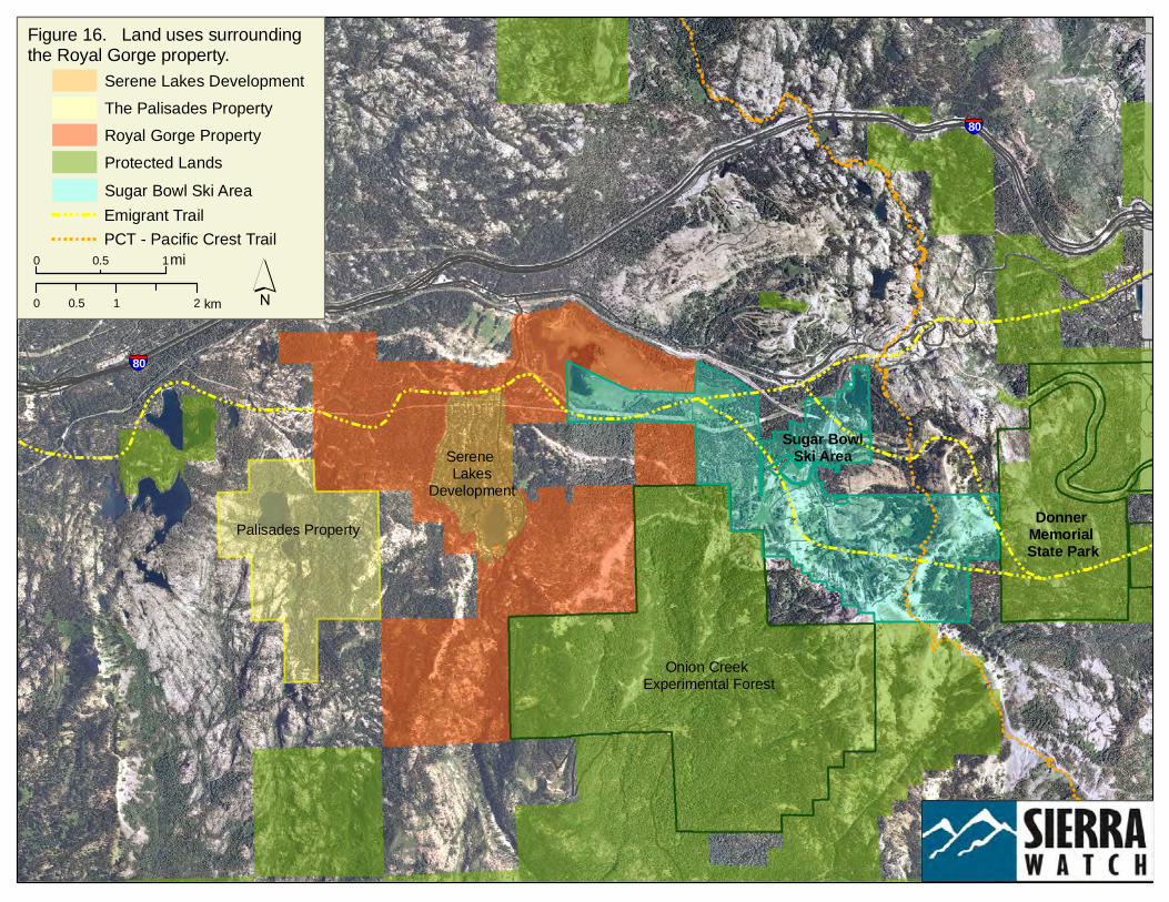
§̈¦80
§̈¦80
Figure 16. Land uses surrounding the Royal Gorge property.
Donner Memorial State Park
Onion Creek Experimental Forest
PCT - Pacific Crest TrailEmigrant Trail
Sugar BowlSki Area
Sugar Bowl Ski Area
Palisades Property
Serene Lakes
Development
0 10.5 mi
0 1 20.5 km ´
The Palisades PropertySerene Lakes Development
Royal Gorge PropertyProtected Lands
Conservation Blueprint for the Donner Summit Royal Gorge Property
Conservation Biology Institute 30 September 2012
Vision for the Royal Gorge Property on Donner Summit Conservation and management of the Donner Summit area, and the Royal Gorge property in particular, should consider a range of issues across multiple spatial and temporal scales to achieve future desired conservation values for the broader landscape. The USFS (2011) National Report on Sustainable Forests identifies 64 indicators of forest sustainability and related policy recommendations, reflecting environmental, social, and economic concerns. The Sierra Forest Legacy has identified high priority issues to be addressed during the process of revising forest plans (Britting et al. 2012), and land managers for the Donner Summit area in general and the Royal Gorge property specifically should engage in this process for revision of the Tahoe National Forest plan. Planning for disposition and stewardship of the Royal Gorge property should include the following science-informed actions, implemented within a regional framework of ecological sustainability−meeting human needs without compromising the health of ecosystems (Callicott and Mumford 1997). Management in the northeast quadrant of the Royal Gorge property (sections 23, 24, 25, and 26) should focus on management of wetland habitats around Lake Van Norden. The southeast and southern quadrants (sections 25, 35, and 3) should focus on management for characteristics of old growth forests, consistent with management in the Onion Creek Experimental Forest and conservation of montane meadows. Management priorities in the northeastern quadrant (sections 27, 28, and 21), where watershed integrity is lowest, should focus on management of montane meadows, old growth forest characteristics, and riparian conservation areas.
Prevent further subdivision and exurban development of private lands outside of existing development clusters, and limit building of new roads, thus reducing the threat of fire.
Develop a resource management framework that identifies the specific investigations, including mapping of vegetation communities, assessment of forest stand heterogeneity (North 2012), mapping of topographic and microclimate variables (North et al. 2009), and surveys for conservation target species, needed to inform preparation of an adaptive management and monitoring plan for the Donner Summit region that accommodates natural ecological succession across a dynamic landscape and that produces forest structure heterogeneity based on differences in aspect and slope shape and position.
Develop goals for maintaining a landscape mosaic of structural diversity, with patches of forests in appropriate areas managed to promote old-growth characteristics in the future, including large-diameter trees, a complex understory, down logs, snags, and open canopy. A greater diversity of habitat structure and complexity will support greater species diversity and abundance and will enhance ecosystem resilience (North 2012).
Conservation Blueprint for the Donner Summit Royal Gorge Property
Conservation Biology Institute 31 September 2012
Manage for mature forest species at a landscape-scale (i.e., considering adjacent properties), including providing foraging habitat and habitat critical to the movement of mature forest species between forests surrounding the Royal Gorge property, e.g., primarily in southern areas of the property (Britting et al. 2012).
Identify and develop special protection guidelines for forest stands supporting nesting areas of northern goshawks, including limiting disturbance during breeding and maintaining post-fledgling areas of 420 acres around goshawk nest stands (Britting et al. 2012). A technical review of northern goshawk in California is expected to be issued by the U.S. Fish and Wildlife Service in September 2012.
Identify potential barriers to landscape connectivity and enhance habitat important to dispersal−from the North Yuba River watershed and its tributaries, south to the South Fork American River−among roadless areas and patches of mature forests that are part of the USFS carnivore network, to facilitate species’ movements and demographic and genetic processes (see recommendations in Appendix A of Britting et al. 2012).
Develop a plan to minimize the potential introduction of invasive plant and animal species, including conducting a risk assessment for potential invasive species (Cal-IPC 2006), establishing an Early Detection Network (Cal-IPC 2003), and implementing Best Management Practices (Cal-IPC 2012a,b) for maintaining powerline easements and use of boating and land vehicles free of invasive species from other areas. Prevent use of rodenticides that are getting into the food chain and killing predatory birds and mammals.
Investigate the opportunities and constraints of decommissioning selected forest roads and trails, especially those that have the potential to impact wet meadows.
Investigate the opportunities and constraints of managing and enhancing the system of wet meadows, USFS-designated Riparian Conservation Areas, and Willow Flycatcher Occupied and Emphasis Areas, including Lake Van Norden. This may include removing the concrete spillway on Lake Van Norden to restore natural ecosystem processes downstream, maintaining 300-ft buffers around streams and wet meadows (USFS 2001), and limiting human uses during the breeding season for neotropical avian migrants and the Sierra Nevada yellow-legged frog. Note that any plans to breach the existing spillway on the lake would eliminate much of the habitat for waterfowl and fish-eating predators such as the bald eagle, and could eliminate habitat around the lake for willow flycatchers and other neotropical migrants, as well as eliminate recreational fishery opportunities (Beedy pers.comm.).
Identify meadows that are candidates for restoration within willow flycatcher dispersal distance. Meadows with willow coverage and structure and restored hydrological regimes may provide greater soil saturation later in the summer season (Green et al. 2003).
Consider opportunities and constraints for restoring habitat for the Sierra Nevada yellow-legged frog habitat, including maintaining connectivity among meadow habitats
Conservation Blueprint for the Donner Summit Royal Gorge Property
Conservation Biology Institute 32 September 2012
and Lake Van Norden. Depending on recreational objectives for the lake, removing non-native fish from Lake Van Norden, to support potential yellow-legged frog conservation, may not be realistic. Identify other places in the region occupied by yellow-legged frogs that could naturally recolonize meadow and stream habitat on the Royal Gorge property.
Work with the Tahoe National Forest to develop a fire management plan that addresses the unnatural accumulation of fuels from fire suppression, focusing on small diameter trees, brush and surface fuels (USFS 2001), and that reduces the threat of catastrophic fire by maintaining adequate distances between ladder fuels and crown fuels, as well as adequate distances between crown fuels. A Wildland Urban Interface zone may be required on the Royal Gorge property adjacent to the Serene Lakes development.
Explore the opportunities to work with Onion Creek Experimental Forest, especially in managing for old growth characteristics on Royal Gorge lands adjacent to the Experimental Forest.
Work with Sugar Bowl and others to develop a plan for low-impact recreational opportunities, with plans for a trails network that avoids sensitive communities such as wet meadows and other wetlands.
Investigate the need for formal conservation easements on the Palisades and Serene Lakes properties, consistent with conservation objectives for the greater Donner Summit region.
Maintain the integrity of existing viewsheds and the availability of wilderness experiences.
Implement public outreach and natural resource education efforts for recreational users, local residents, schools, and businesses.
Partnerships are never as important as where land use is at stake. Passions and funding must be mobilized through strategically coordinated initiatives that take advantage of the varied interests of multiple stakeholders. We need to communicate the framework (big picture) and common goals to funders and how their contributions will be used and leveraged among other partners and contributors. Sustainable use of the area’s rich natural resources is vital to continued tourism and human enjoyment of the region.
Conservation Blueprint for the Donner Summit Royal Gorge Property
Conservation Biology Institute 33 September 2012
5. Literature Cited Beedy, E.C., and P. Brussard. 2002. Nevada County Natural Resources Report. Prepared for
the Nevada County Planning Department, Nevada City, CA.
Beedy, E.C., and C. Chainey-Davis. 2008. Biological inventory of the Palisades property, Placer County, California. Prepared for Shute Mihaly & Weinberger. January.
Beedy, E.C., and E.R. Pandolfino. In press. Birds of the Sierra Nevada: their natural history, status, and distribution. University of California Press, Berkeley, CA.
Britting, S., E. Brown, M. Drew, B. Esch, S. Evans, P. Flick, J. Hatch, R. Henson, D. Morgan, V. Parker, S. Purdy, D. Rivenes, K. Silvas-Bellanca, C. Thomas, and S. VanVelsor. 2012. National Forests in the Sierra Nevada: a conservation strategy. Sierra Forest Legacy. August 27. http://www.sierraforestlegacy.org.
Callicott, J.B., and K. Mumford. 1997. Ecological sustainability as a conservation concept. Conservation Biology 11(1):32-40.
California Department of Fish and Game (CDFG). 1993. Migratory deer herd database. CDFG North Central Region, Rancho Cordova, CA. March.
California Department of Fish and Game (CDFG). 2011. A status review of the mountain yellow-legged frog (Rana sierra and Rana muscosa). Report to the Fish and Game Commission. November 28.
California Invasive Plant Council (Cal-IPC). 2003. Criteria for categorizing invasive non-native plants that threaten wildlands. California Exotic Pest Plant Council Southwest Vegetation Management Association. Electronic version, February 28.
California Invasive Plant Council (Cal-IPC). 2006 (and updates). California invasive plant inventory. Cal-IPC Publication 2006-02. California Invasive Plant Council, Berkeley, CA. www.cal-ipc.org
California Invasive Plant Council (Cal-IPC). 2012a. CalWeedMapper. Accessed July 16. http://www.calweedmapper.calflora.org http://www.cal-ipc.org/ip/inventory/PAF/Chrysanthemum%20coronarium.pdf.
California Invasive Plant Council (Cal-IPC). 2012b. Preventing the spread of invasive plants: best management practices for land managers (3rd ed.). Cal-IPC Publication 2012-03. California Invasive Plant Council, Berkeley, CA. www.cal-ipc.org
Chan, K.M.A., M.R. Shaw, D.R. Cameron, E.C. Underwood, and G.C. Daily. 2006. Conservation planning for ecosystem services. PLoS Biology 4(11):2138-2151.
Cleland, D.T., J.A. Freeouf, J.E. Keys, Jr., G.J. Nowacki, C. Carpenter, and W.H. McNab. 2007. Ecological subregions: sections and subsections of the conterminous United States [1:3,500,000] [CD-ROM]. Sloan, A.M. (cartog.). U.S. Forest Service Gen. Tech. Report WO-76, Washington, DC.
Conservation Blueprint for the Donner Summit Royal Gorge Property
Conservation Biology Institute 34 September 2012
Conservation Biology Institute (CBI). 2010. Protected areas database−California and Nevada. Corvallis, OR. http://databasin.org/protected-center/features/PAD-US-CBI
Davidson, C., and R.A. Knapp. 2007. Multiple stressors and amphibian declines: dual impacts of pesticides and fish on yellow-legged frogs. Ecological Applications 17(2):587-597.
Dawson, N.G., and J.A. Cook. In press. Behind the genes: diversification of North American martens (Martes americana and M. caurina). In Aubry, K, W. Zielinski, M. Raphael, G. Proulx, and S. Buskirk (eds.), Biology and conservation of martens, sables, and fishers: a new synthesis. Cornell University Press, Ithaca, NY.
Endangered Species Coalition. 2011. It’s getting hot out there: top 10 places to save for endangered species in a warming world. Prepared in partnership with Audubon, Center for Biodiversity, Conservation Council for Hawaii, Defenders of Wildlife, Northern California Council–Federation of Fly Fishers, Oceana, Save Our Wild Salmon, and Natural Resources Defense Council.
Fowler, G.S., and R.B. Wagner. 1982. The Blue Canyon deer herd management plan. California Department of Fish and Game in cooperation with the Tahoe National Forest and Eldorado National Forest. Funded by Federal Aid to Wildlife Restoration Project W-51-R, Big Game Investigations. May.
Franklin, J.F., and J.A. Fites-Kaufmann. 1996. Assessment of late-successional forests of the Sierra Nevada. Chapter 21 in Sierra Nevada Ecosystem Project: final report to Congress, vol. II, Assessments and scientific basis for management options. Univ. of California, Davis, Centers for Water and Wildland Resources.
Green, G.A., H.L. Bombay, and M.L. Morrison. 2003. Conservation assessment of the willow flycatcher in the Sierra Nevada. Unpubl. report. March.
Jones & Stokes. 2004. Placer County Natural Resources Report. Prepared by Edward C. Beedy for the Placer County Planning Department, Auburn, CA.
McPhee, J. 1993. Assembling California. Farrar, Straus and Giroux, New York, NY.
Millar, C. 1995. Significant natural areas. Ch. 29 in Sierra Nevada Ecosystem Project, final report to Congress , vol. II, Assessments and scientific basis for management options. Centers for Water and Wildland Resources, University of California, Davis, CA. http://endeavor.des.ucdavis.edu/snep/dataset.asp?dataset=316
Miles, S.R., and C.B. Goudey. 1997. Ecological subregions of California: section and subsection descriptions. USDA Forest Service, R5-EM-TP-005.
Moriarty, K.M., W.J. Zielinski, and E.D. Forsman. 2011. Decline in American marten occupancy rates at Sagehen Experimental Forest, California. Journal of Wildlife Management 75(8):1774-1787.
North, M. (ed.). 2012. Managing Sierra Nevada forests. USFS Pacific Southwest Research Station, Albany, CA. Gen. Tech. Rep. PSW-GTR-237. 184 p.
Conservation Blueprint for the Donner Summit Royal Gorge Property
Conservation Biology Institute 35 September 2012
North, M., P. Stine, K. O'Hara, W. Zielinski, and S. Stephens. 2009. An ecosystem management strategy for Sierran mixed-conifer forests. U.S. Forest Service, Pacific Southwest Research Station, Albany, CA. Gen. Tech. Rep. PSW-GTR-220. 49 p.
North Fork Associates (NFA). 2006a. Biological resources assessment for the ±2,896-acre Royal Gorge study area, Nevada and Placer counties, California. Prepared for Royal Gorge, LLC. Auburn, CA. September.
North Fork Associates (NFA). 2006b. Wetland delineation for the ±2,896-acre Royal Gorge study area, Nevada and Placer counties, California. Prepared for Royal Gorge, LLC. Auburn, CA. September.
Powell, M. 2003. Donner Summit, a brief history. Cottage Hill Publishing, Grass Valley, CA.
Reynolds, R.T., R.T. Graham, M.H. Reiser, and others. 1992. Management recommendations for the northern goshawk in the southwestern United States. U.S. Forest Service Gen. Tech. Rep. RM-217, Ft. Collins, CO.
Schempf, P.F., and M. White. 1977. Status of six furbearer populations in the mountains of northern California. U.S. Forest Service Pacific Southwest Region, Berkeley, CA.
Slauson, K.M., and W.J. Zielinski. 2008. A review of the effects of forest thinning and fuels reduction on American martens (Martes americana) pertinent to the Southern Cascades region of California. Final Report. USDA Forest Service, Southwest Research Station, Redwood Sciences Laboratory.
Spencer, W.D., P. Beier, K. Penrod, K. Winters, C. Paulman, H. Rustigian-Romsos, J. Strittholt, M. Parisi, and A. Pettler. 2010. California Essential Habitat Connectivity Project: A strategy for a connected California. Prepared for California Department of Transportation, California Department of Fish and Game, and Federal Highways Administration.
Spencer, W.D., R.H. Barrett, and W.J. Zielinski. 1983. Marten habitat preferences in the northern Sierra Nevada. Journal Wildlife Management 47:1181-1186.
Spencer, W.D., and H. Rustigian-Romsos. 2012. Decision support maps and recommendations for conserving rare carnivores in the interior mountains of California. Unpublished report. http://consbio.org/products/projects/sierra-nevada-carnivores.
Tahoe National Forest. 2012. Transportation. Nevada City, CA. http://www.fs.usda.gov/detail/r5/landmanagement/gis/?cid=stelprdb5329503
U.S. Forest Service. 1996. Nevada Ecosystem Project (SNEP), final report to Congress; late successional old-growth forest Conditions. Prepared by University of California SNEP science team and special consultants.
U.S. Forest Service. 2001. Sierra Nevada Forest plan amendment, final environmental impact statement. U.S. Forest Service, Pacific Southwest Region. January.
U.S. Forest Service. Vegetation (CALVEG) and special species for the Sierra Nevada region. http://www.fs.fed.us/r5/rsl/clearinghouse/gis-download.shtml

Conservation Blueprint for the Donner Summit Royal Gorge Property
Conservation Biology Institute 36 September 2012
U.S. Forest Service. 2008. Inventoried roadless areas for Region 5. Geospatial Service and Technology Center, Salt Lake City, UT. http://www.fs.usda.gov/detail/r5/landmanagement/gis/?cid=STELPRDB5327833
U.S. Forest Service. 2011. National report on sustainable forests−2010. USDA Forest Service FS-979. June.
U.S. Geological Service (USGS). 2008. GAP ecological systems, USGS mapping zones 5 and 6. USGS GAP program. http://dingo.gapanalysisprogram.com/landcoverv2/DownloadData.aspx
White, M.D., G.E. Heilman, and J.A. Stallcup. 2005. Science assessment for the Sierra Checkerboard Initiative. Prepared for The Trust for Public Land. July.
White, M.D., G.E. Heilman, Jr., and N.A. Budge. 2009. Conservation strategy for implementing the Sierra Checkerboard Initiative. Prepared for The Trust for Public Land, San Francisco, CA. February.
Whitlock, K. 2006. Royal Gorge forest inventory map. Unpublished data.
Wright, J.P., W.S.C. Gurney, and C.G. Jones. 2004. Patch dynamics in a landscape modified by ecosystem engineers. Oikos 105:336-348.
Conservation Blueprint for the Donner Summit Royal Gorge Property
Conservation Biology Institute 37 September 2012
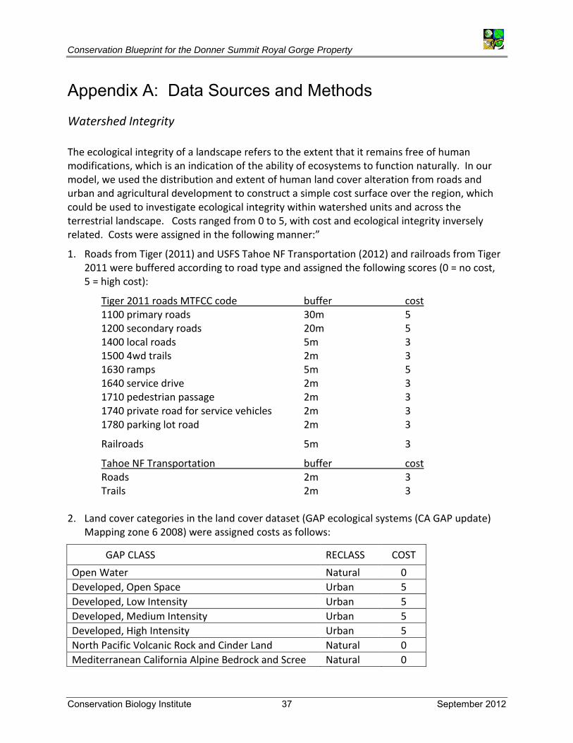
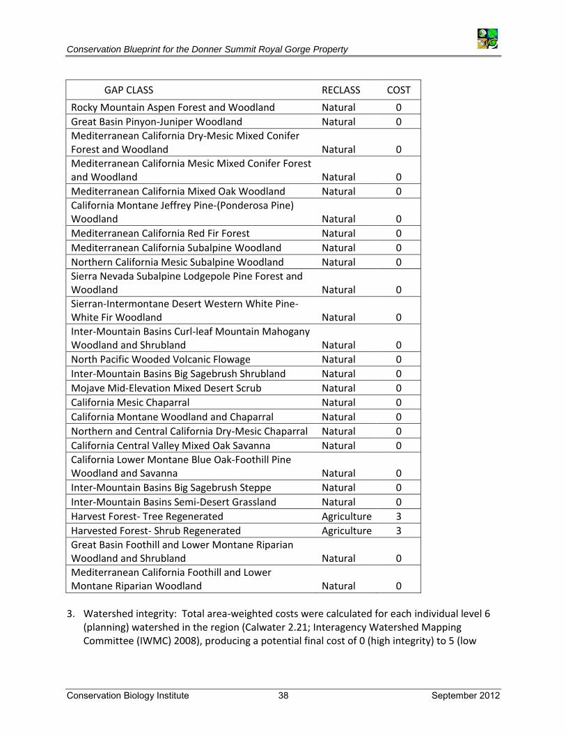
Appendix A: Data Sources and Methods Watershed Integrity The ecological integrity of a landscape refers to the extent that it remains free of human modifications, which is an indication of the ability of ecosystems to function naturally. In our model, we used the distribution and extent of human land cover alteration from roads and urban and agricultural development to construct a simple cost surface over the region, which could be used to investigate ecological integrity within watershed units and across the terrestrial landscape. Costs ranged from 0 to 5, with cost and ecological integrity inversely related. Costs were assigned in the following manner:”
1. Roads from Tiger (2011) and USFS Tahoe NF Transportation (2012) and railroads from Tiger 2011 were buffered according to road type and assigned the following scores (0 = no cost, 5 = high cost):
Tiger 2011 roads MTFCC code buffer cost 1100 primary roads 30m 5 1200 secondary roads 20m 5 1400 local roads 5m 3 1500 4wd trails 2m 3 1630 ramps 5m 5 1640 service drive 2m 3 1710 pedestrian passage 2m 3 1740 private road for service vehicles 2m 3 1780 parking lot road 2m 3
Railroads 5m 3
Tahoe NF Transportation buffer cost Roads 2m 3 Trails 2m 3
2. Land cover categories in the land cover dataset (GAP ecological systems (CA GAP update)
Mapping zone 6 2008) were assigned costs as follows:
GAP CLASS RECLASS COST
Open Water Natural 0
Developed, Open Space Urban 5
Developed, Low Intensity Urban 5
Developed, Medium Intensity Urban 5
Developed, High Intensity Urban 5
North Pacific Volcanic Rock and Cinder Land Natural 0
Mediterranean California Alpine Bedrock and Scree Natural 0
Conservation Blueprint for the Donner Summit Royal Gorge Property
Conservation Biology Institute 38 September 2012
GAP CLASS RECLASS COST
Rocky Mountain Aspen Forest and Woodland Natural 0
Great Basin Pinyon-Juniper Woodland Natural 0
Mediterranean California Dry-Mesic Mixed Conifer Forest and Woodland Natural 0
Mediterranean California Mesic Mixed Conifer Forest and Woodland Natural 0
Mediterranean California Mixed Oak Woodland Natural 0
California Montane Jeffrey Pine-(Ponderosa Pine) Woodland Natural 0
Mediterranean California Red Fir Forest Natural 0
Mediterranean California Subalpine Woodland Natural 0
Northern California Mesic Subalpine Woodland Natural 0
Sierra Nevada Subalpine Lodgepole Pine Forest and Woodland Natural 0
Sierran-Intermontane Desert Western White Pine-White Fir Woodland Natural 0
Inter-Mountain Basins Curl-leaf Mountain Mahogany Woodland and Shrubland Natural 0
North Pacific Wooded Volcanic Flowage Natural 0
Inter-Mountain Basins Big Sagebrush Shrubland Natural 0
Mojave Mid-Elevation Mixed Desert Scrub Natural 0
California Mesic Chaparral Natural 0
California Montane Woodland and Chaparral Natural 0
Northern and Central California Dry-Mesic Chaparral Natural 0
California Central Valley Mixed Oak Savanna Natural 0
California Lower Montane Blue Oak-Foothill Pine Woodland and Savanna Natural 0
Inter-Mountain Basins Big Sagebrush Steppe Natural 0
Inter-Mountain Basins Semi-Desert Grassland Natural 0
Harvest Forest- Tree Regenerated Agriculture 3
Harvested Forest- Shrub Regenerated Agriculture 3
Great Basin Foothill and Lower Montane Riparian Woodland and Shrubland Natural 0
Mediterranean California Foothill and Lower Montane Riparian Woodland Natural 0
3. Watershed integrity: Total area-weighted costs were calculated for each individual level 6
(planning) watershed in the region (Calwater 2.21; Interagency Watershed Mapping Committee (IWMC) 2008), producing a potential final cost of 0 (high integrity) to 5 (low

Conservation Blueprint for the Donner Summit Royal Gorge Property
Conservation Biology Institute 39 September 2012
integrity) for each basin. Watershed integrity scores (Figure 9) were divided into five classes:
Relative Watershed integrity Cost range Very high 0 - 0.1 High 0.10001 – 0.2 Moderate 0.20001 – 0.4 Low 0.40001 – 1.19
Pacific Marten Cores Potential marten habitat cores were delineated by Spencer and Rustigian-Romsos (2012) as part of an effort to provide spatially explicit conservation and management recommendations that can be used to inform management decisions such as conservation action prioritization, National Forest Management Plan revisions, vegetation treatment planning, or other actions that may affect marten and three other species of forest carnivores in the region. Potential marten habitat cores were derived from an empirical marten distribution model created using Maxent software and extensive marten survey data (compiled with assistance from the USFS Redwood Sciences Laboratory). Marten detection data collected from only May to November were used because summer habitat is believed to be most limiting to martens in this region. Prior to input in Maxent, detection data were filtered to a minimum nearest neighbor distance of 7 km to ensure spatial independence (54 detection points) and environmental variables (10; described in table at end) were averaged over a 1-km2 moving window. Potential marten habitat was defined as areas with a predicted probability of occurrence >= 0.4 (open water or urban land cover, steep slopes (> 80%), and recent (post 2005) severe burns (VegBurnSeverity10_1, USDA Forest Service, Pacific Southwest Region, Fire and Aviation Management; 2010) were removed from consideration). Potential marten core areas were then delineated from the potential habitat layer as contiguous polygons of at least 2,500 ha (> 5 marten home range areas). Environmental Variables
1. Latitude-adjusted elevation: 0.625m was added to elevation for every 1 km north from the southernmost point in the study area. Source: USGS 1-Arc Second National Elevation Dataset, 2009
2. WHR type = Wet Meadow, Perennial Grassland, or Annual Grassland with elevation >= 1400m. Distance to nearest mountain meadow
Conservation Blueprint for the Donner Summit Royal Gorge Property
Conservation Biology Institute 40 September 2012
Source: USGS 1-Arc Second National Elevation Dataset, 2009; USDA Forest Service - Pacific Southwest Region - Remote Sensing Lab, Existing Vegetation tiles, 2005 – 2009; California Department of Forestry and Fire Protection, Multi-source Land Cover Data (v02_2), 2002; and NatureServe, Ecological Systems of the United States.
3. Number of high reproduction habitat patches:
Number of CWHR reproduction rating = High (modified by Kirk and Zielinski 2009) patches. Source: Kirk, T.A., Zielinski, W.J. 2009. Developing and testing a landscape habitat suitability model for the American marten (Martes americana) in the Cascades mountains of California. Landscape Ecology 24:759-773; USDA Forest Service - Pacific Southwest Region - Remote Sensing Lab, Existing Vegetation tiles, 2005 – 2009; California Department of Forestry and Fire Protection, Multi-source Land Cover Data (v02_2), 2002; and NatureServe, Ecological Systems of the United States.
4. Average annual precipitation:
Average annual precipitation (mm * 100) 1971 – 2000. Source: PRISM, 30 arc-second (resampled to 30m), 2006
5. Perennial stream density (km/km2).
Source: U.S. National Atlas, Water Feature Lines, 2008
6. Proportion high reproduction habitat rating: Proportion of land with high CWHR reproduction rating (modified by Kirt and Zielinski 2009), CWHR type = LPN, RFR, SCN, WFR, or MRI and WHR size = 4, 5, or 6, and WHR density = M or D. Source: Kirk, T.A., Zielinski, W.J. 2009. Developing and testing a landscape habitat suitability model for the American marten (Martes americana) in the Cascades mountains of California. Landscape Ecology 24:759-773; USDA Forest Service - Pacific Southwest Region - Remote Sensing Lab, Existing Vegetation tiles, 2005 – 2009; California Department of Forestry and Fire Protection, Multi-source Land Cover Data (v02_2), 2002; and NatureServe, Ecological Systems of the United States.
7. Proportion lodgepole pine:
Proportion of land with CWHR type = LPN and WHR size = 4, 5, or 6, and WHR density = M or D. Source: USDA Forest Service - Pacific Southwest Region - Remote Sensing Lab, Existing Vegetation tiles, 2005 – 2009; California Department of Forestry and Fire Protection, Multi-source Land Cover Data (v02_2), 2002; and NatureServe, Ecological Systems of the United States.
Conservation Blueprint for the Donner Summit Royal Gorge Property
Conservation Biology Institute 41 September 2012
8. Proportion red fir: Proportion of land with CWHR type = RFR and WHR size = 4, 5, or 6, and WHR density = M or D. Source: USDA Forest Service - Pacific Southwest Region - Remote Sensing Lab, Existing Vegetation tiles, 2005 – 2009; California Department of Forestry and Fire Protection, Multi-source Land Cover Data (v02_2), 2002; and NatureServe, Ecological Systems of the United States.
9. Proportion Sierran mixed conifer: - Proportion of land with CWHR type = SMC and WHR size = 4, 5, or 6, and WHR density = M or D. Source: USDA Forest Service - Pacific Southwest Region - Remote Sensing Lab, Existing Vegetation tiles, 2005 – 2009; California Department of Forestry and Fire Protection, Multi-source Land Cover Data (v02_2), 2002; and NatureServe, Ecological Systems of the United States.
10. Proportion white fir: Proportion of land with CWHR type = WFR and WHR size = 4, 5, or 6, and WHR density = M or D. Source: USDA Forest Service - Pacific Southwest Region - Remote Sensing Lab, Existing Vegetation tiles, 2005 – 2009; California Department of Forestry and Fire Protection, Multi-source Land Cover Data (v02_2), 2002; and NatureServe, Ecological Systems of the United States.
Conservation Blueprint for the Donner Summit Royal Gorge Property
Conservation Biology Institute 42 September 2012
Appendix B
Prepared by: BEEDY ENVIRONMENTAL CONSULTING 12213 Half Moon Way Nevada City, CA 95959 530-274-7232 B-1 Special Status Animals with Known or Potential Occurrence at the Royal
Gorge Property, Nevada and Placer Counties, California B-2 Special Status Plants with Known or Potential Occurrence at the Royal
Gorge Property, Nevada and Placer Counties, California B-3 List of Vascular Plants Potentially Occurring on the Royal Gorge Property B-4 Vertebrate Species with Known or Potential Occurrence at the Royal
Gorge Property, Nevada and Placer Counties, California
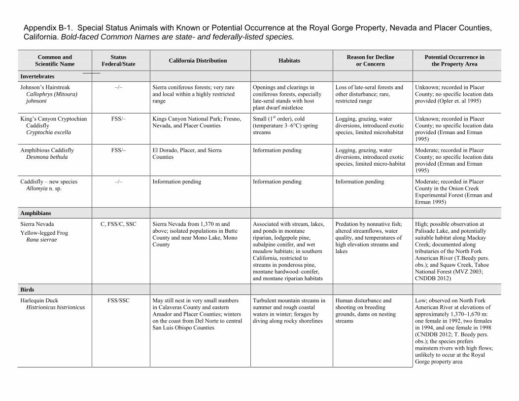
Appendix B-1. Special Status Animals with Known or Potential Occurrence at the Royal Gorge Property, Nevada and Placer Counties, California. Bold-faced Common Names are state- and federally-listed species.
Common and
Scientific Name
Status
Federal/State California Distribution Habitats
Reason for Decline
or Concern
Potential Occurrence in
the Property Area
Invertebrates
Johnson’s Hairstreak Callophrys (Mitoura)
johnsoni
–/– Sierra coniferous forests; very rare and local within a highly restricted range
Openings and clearings in coniferous forests, especially late-seral stands with host plant dwarf mistletoe
Loss of late-seral forests and other disturbance; rare, restricted range
Unknown; recorded in Placer County; no specific location data provided (Opler et. al 1995)
King’s Canyon Cryptochian Caddisfly Cryptochia excella
FSS/– Kings Canyon National Park; Fresno, Nevada, and Placer Counties
Small (1st order), cold (temperature 3–6°C) spring streams
Logging, grazing, water diversions, introduced exotic species, limited microhabitat
Unknown; recorded in Placer County; no specific location data provided (Erman and Erman 1995)
Amphibious Caddisfly Desmona bethula
FSS/– El Dorado, Placer, and Sierra Counties
Information pending Logging, grazing, water diversions, introduced exotic species, limited micro-habitat
Moderate; recorded in Placer County; no specific location data provided (Erman and Erman 1995)
Caddisfly – new species Allomyia n. sp.
–/– Information pending Information pending Information pending Moderate; recorded in Placer County in the Onion Creek Experimental Forest (Erman and Erman 1995)
Amphibians
Sierra Nevada Yellow-legged Frog Rana sierrae
C, FSS/C, SSC Sierra Nevada from 1,370 m and above; isolated populations in Butte County and near Mono Lake, Mono County
Associated with stream, lakes, and ponds in montane riparian, lodgepole pine, subalpine conifer, and wet meadow habitats; in southern California, restricted to streams in ponderosa pine, montane hardwood–conifer, and montane riparian habitats
Predation by nonnative fish; altered streamflows, water quality, and temperatures of high elevation streams and lakes
High; possible observation at Palisade Lake, and potentially suitable habitat along Mackay Creek; documented along tributaries of the North Fork American River (T.Beedy pers. obs.); and Squaw Creek, Tahoe National Forest (MVZ 2003; CNDDB 2012)
Birds
Harlequin Duck Histrionicus histrionicus
FSS/SSC May still nest in very small numbers in Calaveras County and eastern Amador and Placer Counties; winters on the coast from Del Norte to central San Luis Obispo Counties
Turbulent mountain streams in summer and rough coastal waters in winter; forages by diving along rocky shorelines
Human disturbance and shooting on breeding grounds, dams on nesting streams
Low; observed on North Fork American River at elevations of approximately 1,370–1,670 m: one female in 1992, two females in 1994, and one female in 1998 (CNDDB 2012; T. Beedy pers. obs.); the species prefers mainstem rivers with high flows; unlikely to occur at the Royal Gorge property area
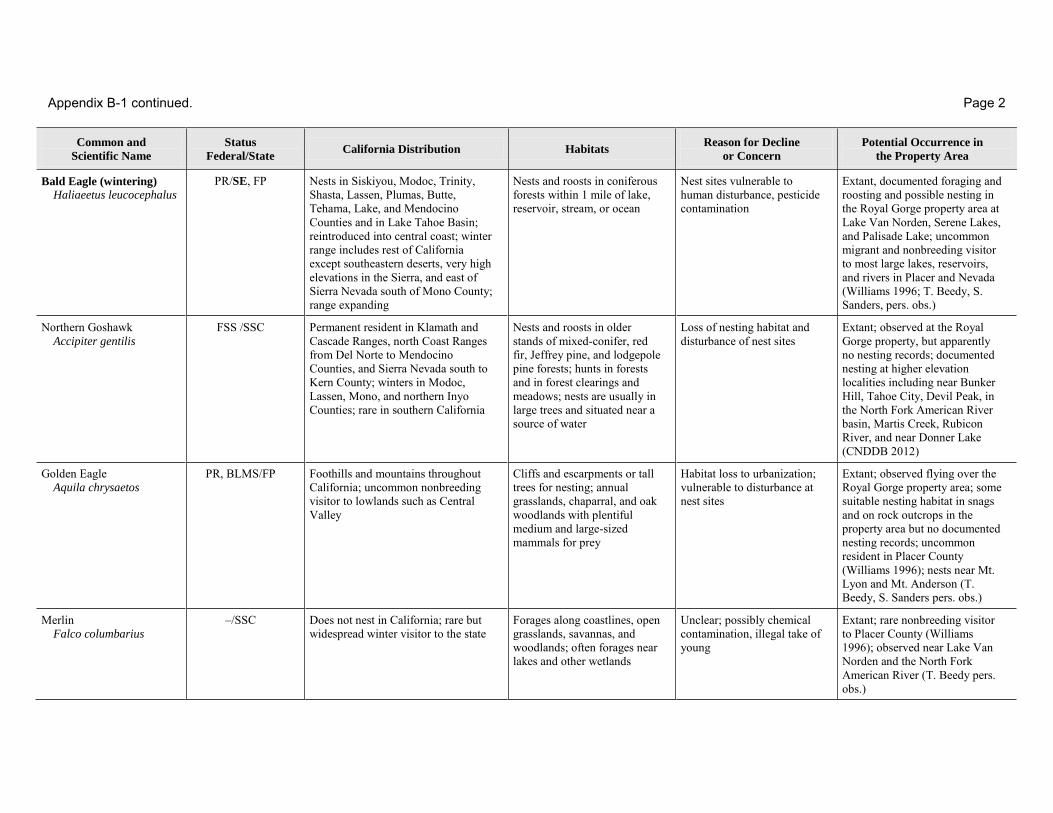
Appendix B-1 continued. Page 2
Common and
Scientific Name
Status
Federal/State California Distribution Habitats
Reason for Decline
or Concern
Potential Occurrence in
the Property Area
Bald Eagle (wintering)
Haliaeetus leucocephalus PR/SE, FP Nests in Siskiyou, Modoc, Trinity,
Shasta, Lassen, Plumas, Butte, Tehama, Lake, and Mendocino Counties and in Lake Tahoe Basin; reintroduced into central coast; winter range includes rest of California except southeastern deserts, very high elevations in the Sierra, and east of Sierra Nevada south of Mono County; range expanding
Nests and roosts in coniferous forests within 1 mile of lake, reservoir, stream, or ocean
Nest sites vulnerable to human disturbance, pesticide contamination
Extant, documented foraging and roosting and possible nesting in the Royal Gorge property area at Lake Van Norden, Serene Lakes, and Palisade Lake; uncommon migrant and nonbreeding visitor to most large lakes, reservoirs, and rivers in Placer and Nevada (Williams 1996; T. Beedy, S. Sanders, pers. obs.)
Northern Goshawk Accipiter gentilis
FSS /SSC Permanent resident in Klamath and Cascade Ranges, north Coast Ranges from Del Norte to Mendocino Counties, and Sierra Nevada south to Kern County; winters in Modoc, Lassen, Mono, and northern Inyo Counties; rare in southern California
Nests and roosts in older stands of mixed-conifer, red fir, Jeffrey pine, and lodgepole pine forests; hunts in forests and in forest clearings and meadows; nests are usually in large trees and situated near a source of water
Loss of nesting habitat and disturbance of nest sites
Extant; observed at the Royal Gorge property, but apparently no nesting records; documented nesting at higher elevation localities including near Bunker Hill, Tahoe City, Devil Peak, in the North Fork American River basin, Martis Creek, Rubicon River, and near Donner Lake (CNDDB 2012)
Golden Eagle Aquila chrysaetos
PR, BLMS/FP Foothills and mountains throughout California; uncommon nonbreeding visitor to lowlands such as Central Valley
Cliffs and escarpments or tall trees for nesting; annual grasslands, chaparral, and oak woodlands with plentiful medium and large-sized mammals for prey
Habitat loss to urbanization; vulnerable to disturbance at nest sites
Extant; observed flying over the Royal Gorge property area; some suitable nesting habitat in snags and on rock outcrops in the property area but no documented nesting records; uncommon resident in Placer County (Williams 1996); nests near Mt. Lyon and Mt. Anderson (T. Beedy, S. Sanders pers. obs.)
Merlin Falco columbarius
–/SSC Does not nest in California; rare but widespread winter visitor to the state
Forages along coastlines, open grasslands, savannas, and woodlands; often forages near lakes and other wetlands
Unclear; possibly chemical contamination, illegal take of young
Extant; rare nonbreeding visitor to Placer County (Williams 1996); observed near Lake Van Norden and the North Fork American River (T. Beedy pers. obs.)

Appendix B-1 continued. Page 3
American Peregrine Falcon
Falco peregrinus anatum -/FP Permanent resident in North and
South Coast Ranges; may summer in Cascade and Klamath Ranges south through Sierra Nevada to Madera County; winters in Central Valley south through Transverse and Peninsular Ranges and plains east of Cascade Range
Nests and roosts on protected ledges of high cliffs, usually adjacent to lakes, rivers, or marshes that support large populations of other bird species
Pesticide contamination; population recovering
Extant; an active nesting eyrie was found on the Royal Gorge property (Whitlock pers. comm.); nesting has been documented in the North Fork American River canyon upstream from Auburn; otherwise, rare migrants in the Royal Gorge area
Prairie Falcon Falco mexicanus
FWC/- Found as permanent resident in South Coast, Transverse, Peninsular, and northern Cascade Ranges; southeastern deserts; Inyo-White Mountains; Modoc, Lassen, and Plumas Counties; and foothills surrounding Central Valley. Winters in Central Valley; along coast from Santa Barbara to San Diego Counties; and in Marin, Sonoma, Humboldt, Del Norte, and Inyo Counties
Nests on cliffs or escarpments; forages in adjacent dry, open terrain or uplands, marshes, and seasonal marshes
Possibly pesticide contamination, robbing of eyries by falconers, illegal shooting, human disturbance at nest site
Extant; uncommon migrant and winter resident in Placer County; observed near Crow’s Nest, Mt. Lyon, Tinker’s Knob, Granite Chief, Mt. Lincoln, Sugar Bowl, South of Norden, and Squaw Peak (Williams 1996; T. Beedy, S. Sanders pers. obs
California Spotted Owl Strix occidentalis
occidentalis
FWC, FSS, BLMS/SSC
Sierra Nevada from Lassen to northern Kern Counties; occurs in localized areas of Transverse and Peninsular Ranges of southern California
Mature forest with permanent water and suitable nesting trees and snags; in southern California, nearly always associated with oak and oak-conifer habitats
Loss of late-seral nesting habitat
High; fairly common nesters in late-seral forests of headwaters basin of North Fork American River including the adjacent Onion Creek Experimental Forest but little suitable nesting habitat on the Royal Gorge property (CNDDB 2012, T. Beedy, S. Sanders pers. obs.)
Great Gray Owl Strix nebulosa
FWC/SE Permanent resident of the Sierra Nevada in small portions of Tuolumne, Mariposa, Madera, and Fresno Counties
Late-seral coniferous forests bordering meadows; red fir, Jeffrey pine, and lodgepole pine dominate
Loss of late-seral nesting habitat, degradation of foraging habitat in meadows
Low; nonbreeding individuals observed in Nevada and Sierra counties; no breeding records from Nevada or Placer counties (CNDDB 2012)
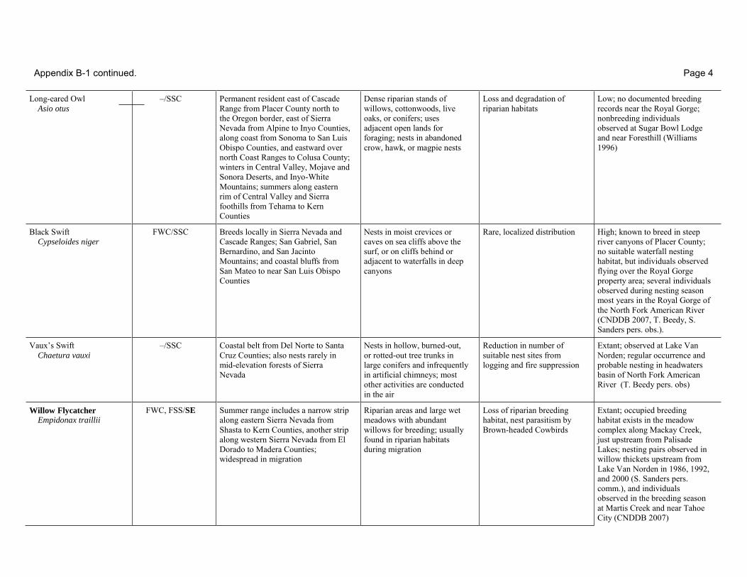
Appendix B-1 continued. Page 4
Long-eared Owl Asio otus
–/SSC Permanent resident east of Cascade Range from Placer County north to the Oregon border, east of Sierra Nevada from Alpine to Inyo Counties, along coast from Sonoma to San Luis Obispo Counties, and eastward over north Coast Ranges to Colusa County; winters in Central Valley, Mojave and Sonora Deserts, and Inyo-White Mountains; summers along eastern rim of Central Valley and Sierra foothills from Tehama to Kern Counties
Dense riparian stands of willows, cottonwoods, live oaks, or conifers; uses adjacent open lands for foraging; nests in abandoned crow, hawk, or magpie nests
Loss and degradation of riparian habitats
Low; no documented breeding records near the Royal Gorge; nonbreeding individuals observed at Sugar Bowl Lodge and near Foresthill (Williams 1996)
Black Swift Cypseloides niger
FWC/SSC Breeds locally in Sierra Nevada and Cascade Ranges; San Gabriel, San Bernardino, and San Jacinto Mountains; and coastal bluffs from San Mateo to near San Luis Obispo Counties
Nests in moist crevices or caves on sea cliffs above the surf, or on cliffs behind or adjacent to waterfalls in deep canyons
Rare, localized distribution High; known to breed in steep river canyons of Placer County; no suitable waterfall nesting habitat, but individuals observed flying over the Royal Gorge property area; several individuals observed during nesting season most years in the Royal Gorge of the North Fork American River (CNDDB 2007, T. Beedy, S. Sanders pers. obs.).
Vaux’s Swift Chaetura vauxi
–/SSC Coastal belt from Del Norte to Santa Cruz Counties; also nests rarely in mid-elevation forests of Sierra Nevada
Nests in hollow, burned-out, or rotted-out tree trunks in large conifers and infrequently in artificial chimneys; most other activities are conducted in the air
Reduction in number of suitable nest sites from logging and fire suppression
Extant; observed at Lake Van Norden; regular occurrence and probable nesting in headwaters basin of North Fork American River (T. Beedy pers. obs)
Willow Flycatcher Empidonax traillii
FWC, FSS/SE Summer range includes a narrow strip along eastern Sierra Nevada from Shasta to Kern Counties, another strip along western Sierra Nevada from El Dorado to Madera Counties; widespread in migration
Riparian areas and large wet meadows with abundant willows for breeding; usually found in riparian habitats during migration
Loss of riparian breeding habitat, nest parasitism by Brown-headed Cowbirds
Extant; occupied breeding habitat exists in the meadow complex along Mackay Creek, just upstream from Palisade Lakes; nesting pairs observed in willow thickets upstream from Lake Van Norden in 1986, 1992, and 2000 (S. Sanders pers. comm.), and individuals observed in the breeding season at Martis Creek and near Tahoe City (CNDDB 2007)
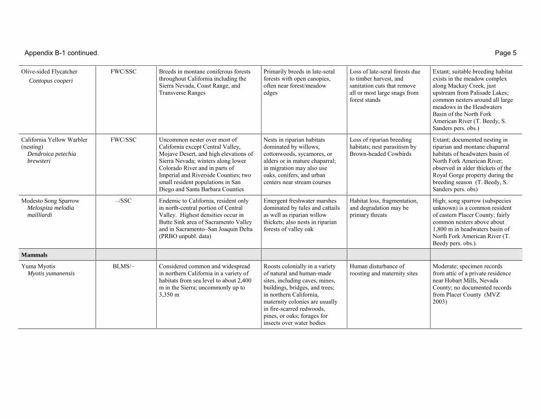
Appendix B-1 continued. Page 5
Olive-sided Flycatcher Contopus cooperi
FWC/SSC Breeds in montane coniferous forests throughout California including the Sierra Nevada, Coast Range, and Transverse Ranges
Primarily breeds in late-seral forests with open canopies, often near forest/meadow edges
Loss of late-seral forests due to timber harvest, and sanitation cuts that remove all or most large snags from forest stands
Extant; suitable breeding habitat exists in the meadow complex along Mackay Creek, just upstream from Palisade Lakes; common nesters around all large meadows in the Headwaters Basin of the North Fork American River (T. Beedy, S. Sanders pers. obs.)
California Yellow Warbler (nesting) Dendroica petechia
brewsteri
FWC/SSC Uncommon nester over most of California except Central Valley, Mojave Desert, and high elevations of Sierra Nevada; winters along lower Colorado River and in parts of Imperial and Riverside Counties; two small resident populations in San Diego and Santa Barbara Counties
Nests in riparian habitats dominated by willows, cottonwoods, sycamores, or alders or in mature chaparral; in migration may also use oaks, conifers, and urban centers near stream courses
Loss of riparian breeding habitats; nest parasitism by Brown-headed Cowbirds
Extant; documented nesting in riparian and montane chaparral habitats of headwaters basin of North Fork American River; observed in alder thickets of the Royal Gorge property during the breeding season (T. Beedy, S. Sanders pers. obs)
Modesto Song Sparrow
Melospiza melodia
mailliardi
–/SSC Endemic to California, resident only in north-central portion of Central Valley. Highest densities occur in Butte Sink area of Sacramento Valley and in Sacramento–San Joaquin Delta (PRBO unpubl. data)
Emergent freshwater marshes dominated by tules and cattails as well as riparian willow thickets; also nests in riparian forests of valley oak
Habitat loss, fragmentation, and degradation may be primary threats
High; song sparrow (subspecies unknown) is a common resident of eastern Placer County; fairly common nesters above about 1,800 m in headwaters basin of North Fork American River (T. Beedy pers. obs.).
Mammals
Yuma Myotis Myotis yumanensis
BLMS/– Considered common and widespread in northern California in a variety of habitats from sea level to about 2,400 m in the Sierra; uncommonly up to 3,350 m
Roosts colonially in a variety of natural and human-made sites, including caves, mines, buildings, bridges, and trees; in northern California, maternity colonies are usually in fire-scarred redwoods, pines, or oaks; forages for insects over water bodies
Human disturbance of roosting and maternity sites
Moderate; specimen records from attic of a private residence near Hobart Mills, Nevada County; no documented records from Placer County (MVZ 2003)
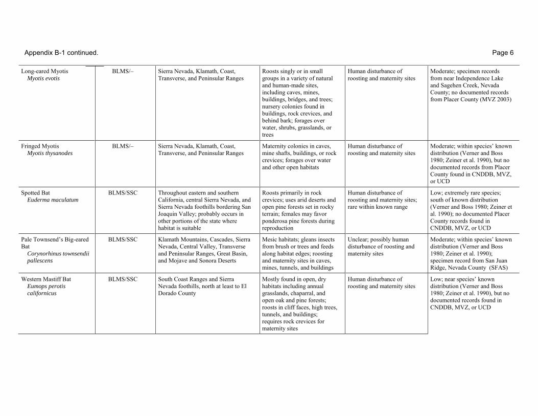
Appendix B-1 continued. Page 6
Long-eared Myotis Myotis evotis
BLMS/– Sierra Nevada, Klamath, Coast, Transverse, and Peninsular Ranges
Roosts singly or in small groups in a variety of natural and human-made sites, including caves, mines, buildings, bridges, and trees; nursery colonies found in buildings, rock crevices, and behind bark; forages over water, shrubs, grasslands, or trees
Human disturbance of roosting and maternity sites
Moderate; specimen records from near Independence Lake and Sagehen Creek, Nevada County; no documented records from Placer County (MVZ 2003)
Fringed Myotis Myotis thysanodes
BLMS/– Sierra Nevada, Klamath, Coast, Transverse, and Peninsular Ranges
Maternity colonies in caves, mine shafts, buildings, or rock crevices; forages over water and other open habitats
Human disturbance of roosting and maternity sites
Moderate; within species’ known distribution (Verner and Boss 1980; Zeiner et al. 1990), but no documented records from Placer County found in CNDDB, MVZ, or UCD
Spotted Bat Euderma maculatum
BLMS/SSC Throughout eastern and southern California, central Sierra Nevada, and Sierra Nevada foothills bordering San Joaquin Valley; probably occurs in other portions of the state where habitat is suitable
Roosts primarily in rock crevices; uses arid deserts and open pine forests set in rocky terrain; females may favor ponderosa pine forests during reproduction
Human disturbance of roosting and maternity sites; rare within known range
Low; extremely rare species; south of known distribution (Verner and Boss 1980; Zeiner et al. 1990); no documented Placer County records found in CNDDB, MVZ, or UCD
Pale Townsend’s Big-eared Bat Corynorhinus townsendii
pallescens
BLMS/SSC Klamath Mountains, Cascades, Sierra Nevada, Central Valley, Transverse and Peninsular Ranges, Great Basin, and Mojave and Sonora Deserts
Mesic habitats; gleans insects from brush or trees and feeds along habitat edges; roosting and maternity sites in caves, mines, tunnels, and buildings
Unclear; possibly human disturbance of roosting and maternity sites
Moderate; within species’ known distribution (Verner and Boss 1980; Zeiner et al. 1990); specimen record from San Juan Ridge, Nevada County (SFAS)
Western Mastiff Bat Eumops perotis
californicus
BLMS/SSC South Coast Ranges and Sierra Nevada foothills, north at least to El Dorado County
Mostly found in open, dry habitats including annual grasslands, chaparral, and open oak and pine forests; roosts in cliff faces, high trees, tunnels, and buildings; requires rock crevices for maternity sites
Human disturbance of roosting and maternity sites
Low; near species’ known distribution (Verner and Boss 1980; Zeiner et al. 1990), but no documented records found in CNDDB, MVZ, or UCD
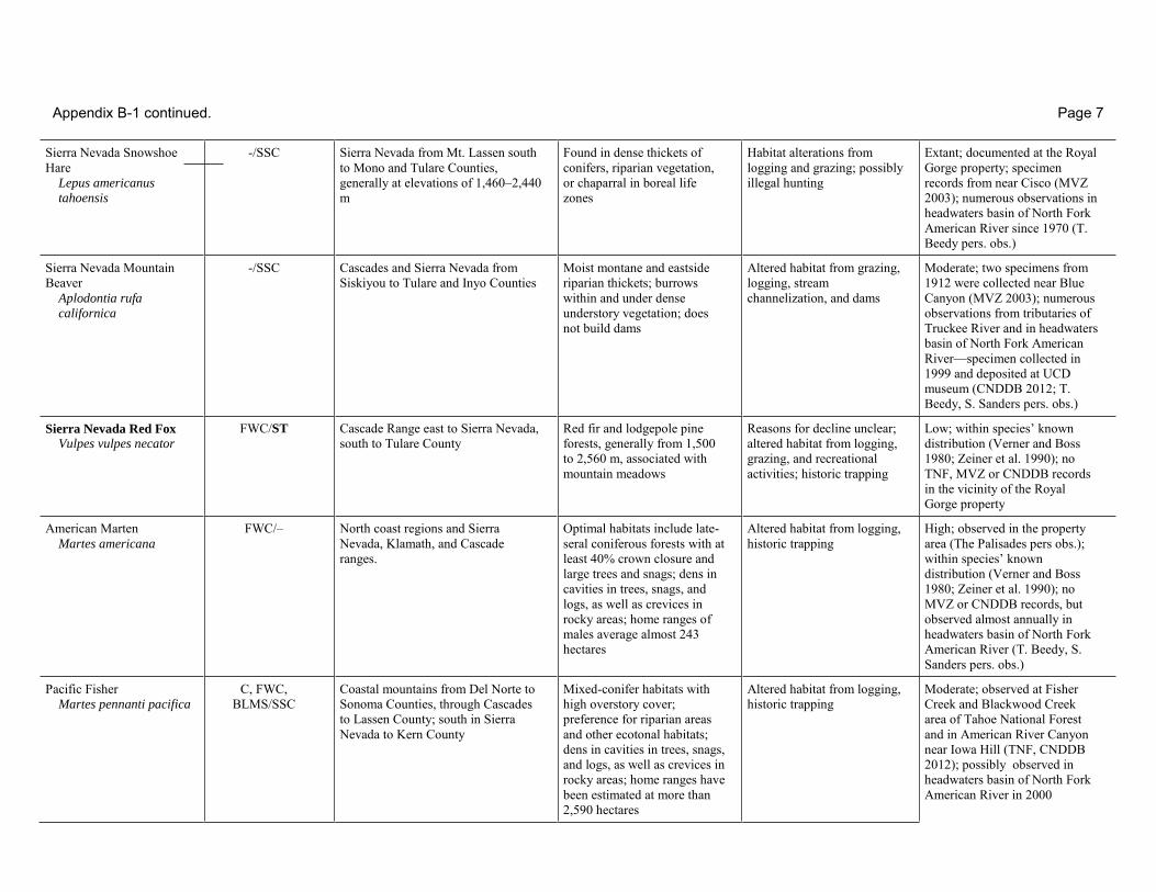
Appendix B-1 continued. Page 7
Sierra Nevada Snowshoe Hare Lepus americanus
tahoensis
-/SSC Sierra Nevada from Mt. Lassen south to Mono and Tulare Counties, generally at elevations of 1,460–2,440 m
Found in dense thickets of conifers, riparian vegetation, or chaparral in boreal life zones
Habitat alterations from logging and grazing; possibly illegal hunting
Extant; documented at the Royal Gorge property; specimen records from near Cisco (MVZ 2003); numerous observations in headwaters basin of North Fork American River since 1970 (T. Beedy pers. obs.)
Sierra Nevada Mountain Beaver Aplodontia rufa
californica
-/SSC Cascades and Sierra Nevada from Siskiyou to Tulare and Inyo Counties
Moist montane and eastside riparian thickets; burrows within and under dense understory vegetation; does not build dams
Altered habitat from grazing, logging, stream channelization, and dams
Moderate; two specimens from 1912 were collected near Blue Canyon (MVZ 2003); numerous observations from tributaries of Truckee River and in headwaters basin of North Fork American River—specimen collected in 1999 and deposited at UCD museum (CNDDB 2012; T. Beedy, S. Sanders pers. obs.)
Sierra Nevada Red Fox Vulpes vulpes necator
FWC/ST Cascade Range east to Sierra Nevada, south to Tulare County
Red fir and lodgepole pine forests, generally from 1,500 to 2,560 m, associated with mountain meadows
Reasons for decline unclear; altered habitat from logging, grazing, and recreational activities; historic trapping
Low; within species’ known distribution (Verner and Boss 1980; Zeiner et al. 1990); no TNF, MVZ or CNDDB records in the vicinity of the Royal Gorge property
American Marten Martes americana
FWC/– North coast regions and Sierra Nevada, Klamath, and Cascade ranges.
Optimal habitats include late-seral coniferous forests with at least 40% crown closure and large trees and snags; dens in cavities in trees, snags, and logs, as well as crevices in rocky areas; home ranges of males average almost 243 hectares
Altered habitat from logging, historic trapping
High; observed in the property area (The Palisades pers obs.); within species’ known distribution (Verner and Boss 1980; Zeiner et al. 1990); no MVZ or CNDDB records, but observed almost annually in headwaters basin of North Fork American River (T. Beedy, S. Sanders pers. obs.)
Pacific Fisher Martes pennanti pacifica
C, FWC, BLMS/SSC
Coastal mountains from Del Norte to Sonoma Counties, through Cascades to Lassen County; south in Sierra Nevada to Kern County
Mixed-conifer habitats with high overstory cover; preference for riparian areas and other ecotonal habitats; dens in cavities in trees, snags, and logs, as well as crevices in rocky areas; home ranges have been estimated at more than 2,590 hectares
Altered habitat from logging, historic trapping
Moderate; observed at Fisher Creek and Blackwood Creek area of Tahoe National Forest and in American River Canyon near Iowa Hill (TNF, CNDDB 2012); possibly observed in headwaters basin of North Fork American River in 2000

Appendix B-1 continued. Page 8
California Wolverine Gulo gulo luteus
FWC, FS/ST, FP Klamath and Cascade Ranges south through Sierra Nevada to Tulare County
Sighted in a variety of habitats from 490 to 4,328 m; most common in open terrain above timberline and subalpine forests; dens in caves, cliffs, hollow logs, under rocks, and in excavated cavities in ground or snow; home ranges have been estimated at more than 3,885 hectares
Reason for decline unclear; altered habitat from logging and recreation activities; historic trapping
Moderate; within species’ known distribution (Verner and Boss 1980; Zeiner et al. 1990); a single male was photographed at Sagehen Creek from 2009 to 2012; another (possibly the same animal) was photographed at Lake Spaulding in 2012; also observed in 1953 near entrance to Squaw Valley and in 1978 at Sunflower Hill near French Meadows Reservoir (TNF, CNDDB 2012)
American Badger Taxidea taxus
–/SSC Most of California except extreme north coastal regions of Humboldt, Del Norte, and Siskiyou Counties
Suitable habitats include herbaceous and shrub communities and open stages of most other habitats with dry, friable soils where dens are excavated; home ranges can be up to 243 hectares
Reason for decline unclear; probably related to habitat loss in developed and agricultural areas where soils are excavated
High; within species’ known distribution (Verner and Boss 1980; Zeiner et al. 1990); active burrows observed in headwaters basin of North Fork American River since the 1970s (T. Beedy pers. obs.)
Federal Status FE = Listed as Endangered under the federal Endangered Species Act. FT = Listed as Threatened under the federal Endangered Species Act. FC = Candidate for listing as either Threatened or Endangered under the federal Endangered Species Act. PR = Protected under the Bald Eagle and Golden Eagle Protection Act FWC = Considered a species of Conservation Concern by the U.S. Fish and Wildlife Service FSS = Considered a Sensitive Species by the U.S. Forest Service BLMS = Considered a Sensitive Species by the U.S. Bureau of Land Management – = No federal protected status. State Status
SE = Listed as Endangered under the California Endangered Species Act. ST = Listed as Threatened under the California Endangered Species Act. SC = Candidate for listing as either Threatened or Endangered under the state Endangered Species Act. FP = Fully-protected under the California Fish and Game Code. SSC = Considered a Species of Special Concern by the California Department of Fish and Game – = No state protected status.

Appendix B-1 continued. Page 9
Literature Cited
Published References: Beedy, E.C., and E.R. Pandolfino. In press. Birds of the Sierra Nevada: Their Natural History, Status, and Distribution. University of California Press, Berkeley, CA. California Department of Fish and Game. 2012. Special Animals. Compiled by the California Natural Diversity Data Base, Sacramento, CA. Erman, N.A. 1994. Factors affecting the distribution of a new species of Allomyia (Trichoptera: Apataniidae) in cold springs of the Sierra Nevada, California, USA in The Proceedings of the 8th
International Symposium on Trichoptera, pp. 89–93 (Ohio Biological Survey). Erman, N.A., and D.C. Erman. 1995. Spring Permanence, Trichoptera Species Richness, and the Role of Drought. J. Kansas Entomological Soc., 68(2) suppl.. pp. 50-64. Grinnell, J., and A.H. Miller. 1944. The distribution of the birds of California. Pacific Coast Avifauna 27. Berkeley, CA Jennings, M.R., and M.P. Hayes. 1994. Amphibian and reptile species of special concern in California. California Department of Fish and Game, Rancho Cordova, CA Moyle, P. B. 1976. Inland fishes of California. University of California Press, Berkeley, CA Moyle, P.B., Y. Yoshiyama, J.E. Williams, and E.D. Wikramanyake. 1995. Fish species of special concern in California. Final Report submitted to the Department of Fish and Game Inland
Fisheries Division under contract No. 2128IF. Remsen, J.V., Jr. 1978. Bird species of special concern in California. Project PR W-54-R-9, Nongame Wildlife Investigations, Wildlife Management Branch Administrative Report No. 78-1. Opler, P.A., H. Pavulaan, and R.E. Stanford (coordinators). 1995. Butterflies of North America. Jamestown, ND: Northern Prairie Wildlife Research Center Home Page.
http://www.npwrc.usgs.gov/resource/distr/lepid/bflyusa/bflyusa.htm (Version 30DEC2002). Shuford, W.D., and Gardali, T. (eds.) 2008. California Bird Species of Special Concern: A Ranked Assessment of Species, Subspecies, and Distinct Populations of Birds of Immediate Conservation
Concern in California. Studies of Western Birds 1. Western Field Ornithologists, Camarillo, California, and Calif. Dept. of Fish and Game, Sacramento, CA. Verner, J. and A.S. Boss. 1980. California wildlife and their habitats: western Sierra Nevada. Gen. Tech Report. PSW-37. Pacific Southwest Range Exp. Station., U.S. Forest Service, Department of
Agriculture, Berkeley, CA Webb, B. 2003. Seasonal checklist of the Birds of Placer County. www.geocities.com/placerbird/PlacerCountyBirds.htm Williams, B.D.C. 1996. Seasonal checklist of the birds of Placer County, Sierra College Natural History Museum and Sierra Foothills Audubon Society Williams, D. F. 1986. Mammalian species of special concern in California. Wildlife Management Division Administrative Report 86-1. Zeiner, D.C., W.F. Laudenslayer, Jr., K.E. Mayer, and M. White. 1990. California’s wildlife. Volume I: Reptiles and amphibians; Volume II: Birds; Volume III: Mammals. California Department
of Fish and Game, Sacramento, CA. Personal Communications:
Sanders, Susan. Ph.D. Wildlife Biologist, Nevada City, CA Whitlock, Kevin. Registered Professional Forester, Nevada City, CA Museums and Data Bases: (CNDDB) Records search (2012) of the California Department of Fish and Game’s Natural Diversity Data Base for Placer and Nevada Counties, Sacramento, CA (MVZ) Records search (2003) of the Museum of Vertebrate Zoology, University of California, Berkeley, CA (SFAS) Unpublished Placer County field notes and databases compiled by members of the Sierra Foothills Audubon Society, Grass Valley, CA (TNF) Tahoe National Forest wildlife and fisheries files, Nevada City, CA (2002 record searches by U.S. Forest Service personnel) (UCD) Records search of the Wildlife and Entomology Museums, University of California, Davis (2001) (UNR) Records search of the Wildlife Museum, University of Nevada, Reno (2002)
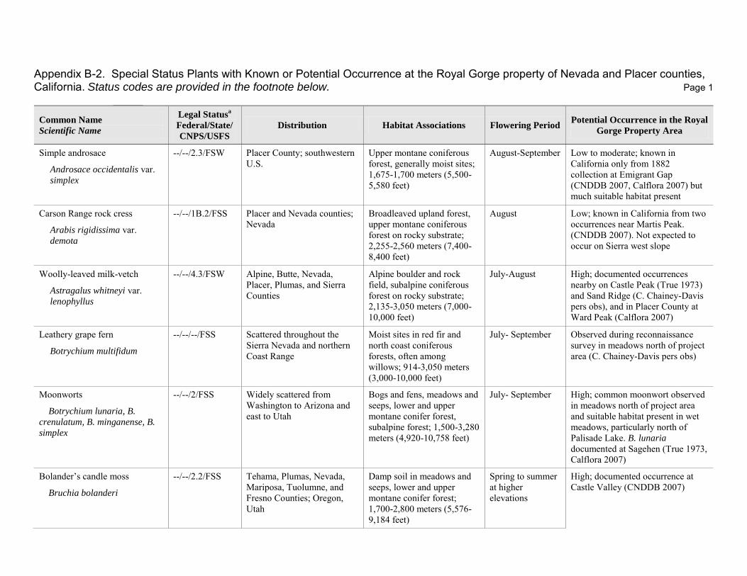
Appendix B-2. Special Status Plants with Known or Potential Occurrence at the Royal Gorge property of Nevada and Placer counties, California. Status codes are provided in the footnote below. Page 1
Common Name
Scientific Name
Legal Statusa
Federal/State/
CNPS/USFS
Distribution Habitat Associations Flowering Period Potential Occurrence in the Royal
Gorge Property Area
Simple androsace
Androsace occidentalis var. simplex
--/--/2.3/FSW Placer County; southwestern U.S.
Upper montane coniferous forest, generally moist sites; 1,675-1,700 meters (5,500-5,580 feet)
August-September Low to moderate; known in California only from 1882 collection at Emigrant Gap (CNDDB 2007, Calflora 2007) but much suitable habitat present
Carson Range rock cress
Arabis rigidissima var. demota
--/--/1B.2/FSS Placer and Nevada counties; Nevada
Broadleaved upland forest, upper montane coniferous forest on rocky substrate; 2,255-2,560 meters (7,400-8,400 feet)
August Low; known in California from two occurrences near Martis Peak. (CNDDB 2007). Not expected to occur on Sierra west slope
Woolly-leaved milk-vetch
Astragalus whitneyi var. lenophyllus
--/--/4.3/FSW Alpine, Butte, Nevada, Placer, Plumas, and Sierra Counties
Alpine boulder and rock field, subalpine coniferous forest on rocky substrate; 2,135-3,050 meters (7,000-10,000 feet)
July-August High; documented occurrences nearby on Castle Peak (True 1973) and Sand Ridge (C. Chainey-Davis pers obs), and in Placer County at Ward Peak (Calflora 2007)
Leathery grape fern
Botrychium multifidum
--/--/--/FSS Scattered throughout the Sierra Nevada and northern Coast Range
Moist sites in red fir and north coast coniferous forests, often among willows; 914-3,050 meters (3,000-10,000 feet)
July- September Observed during reconnaissance survey in meadows north of project area (C. Chainey-Davis pers obs)
Moonworts
Botrychium lunaria, B.
crenulatum, B. minganense, B.
simplex
--/--/2/FSS Widely scattered from Washington to Arizona and east to Utah
Bogs and fens, meadows and seeps, lower and upper montane conifer forest, subalpine forest; 1,500-3,280 meters (4,920-10,758 feet)
July- September High; common moonwort observed in meadows north of project area and suitable habitat present in wet meadows, particularly north of Palisade Lake. B. lunaria documented at Sagehen (True 1973, Calflora 2007)
Bolander’s candle moss
Bruchia bolanderi
--/--/2.2/FSS Tehama, Plumas, Nevada, Mariposa, Tuolumne, and Fresno Counties; Oregon, Utah
Damp soil in meadows and seeps, lower and upper montane conifer forest; 1,700-2,800 meters (5,576-9,184 feet)
Spring to summer at higher elevations
High; documented occurrence at Castle Valley (CNDDB 2007)
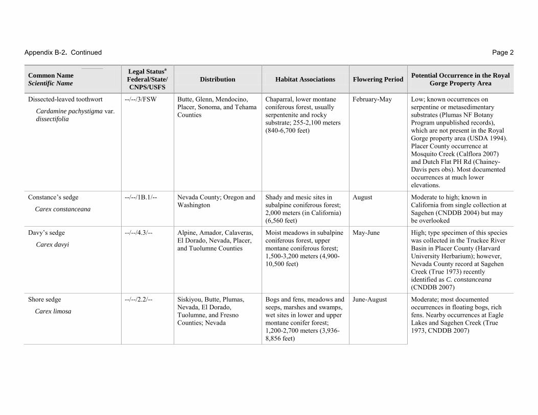
Appendix B-2. Continued Page 2
Common Name
Scientific Name
Legal Statusa
Federal/State/
CNPS/USFS
Distribution Habitat Associations Flowering Period Potential Occurrence in the Royal
Gorge Property Area
Dissected-leaved toothwort
Cardamine pachystigma var. dissectifolia
--/--/3/FSW Butte, Glenn, Mendocino, Placer, Sonoma, and Tehama Counties
Chaparral, lower montane coniferous forest, usually serpentenite and rocky substrate; 255-2,100 meters (840-6,700 feet)
February-May Low; known occurrences on serpentine or metasedimentary substrates (Plumas NF Botany Program unpublished records), which are not present in the Royal Gorge property area (USDA 1994). Placer County occurrence at Mosquito Creek (Calflora 2007) and Dutch Flat PH Rd (Chainey-Davis pers obs). Most documented occurrences at much lower elevations.
Constance’s sedge
Carex constanceana
--/--/1B.1/-- Nevada County; Oregon and Washington
Shady and mesic sites in subalpine coniferous forest; 2,000 meters (in California) (6,560 feet)
August Moderate to high; known in California from single collection at Sagehen (CNDDB 2004) but may be overlooked
Davy’s sedge
Carex davyi
--/--/4.3/-- Alpine, Amador, Calaveras, El Dorado, Nevada, Placer, and Tuolumne Counties
Moist meadows in subalpine coniferous forest, upper montane coniferous forest; 1,500-3,200 meters (4,900-10,500 feet)
May-June High; type specimen of this species was collected in the Truckee River Basin in Placer County (Harvard University Herbarium); however, Nevada County record at Sagehen Creek (True 1973) recently identified as C. constanceana (CNDDB 2007)
Shore sedge
Carex limosa
--/--/2.2/-- Siskiyou, Butte, Plumas, Nevada, El Dorado, Tuolumne, and Fresno Counties; Nevada
Bogs and fens, meadows and seeps, marshes and swamps, wet sites in lower and upper montane conifer forest; 1,200-2,700 meters (3,936-8,856 feet)
June-August Moderate; most documented occurrences in floating bogs, rich fens. Nearby occurrences at Eagle Lakes and Sagehen Creek (True 1973, CNDDB 2007)
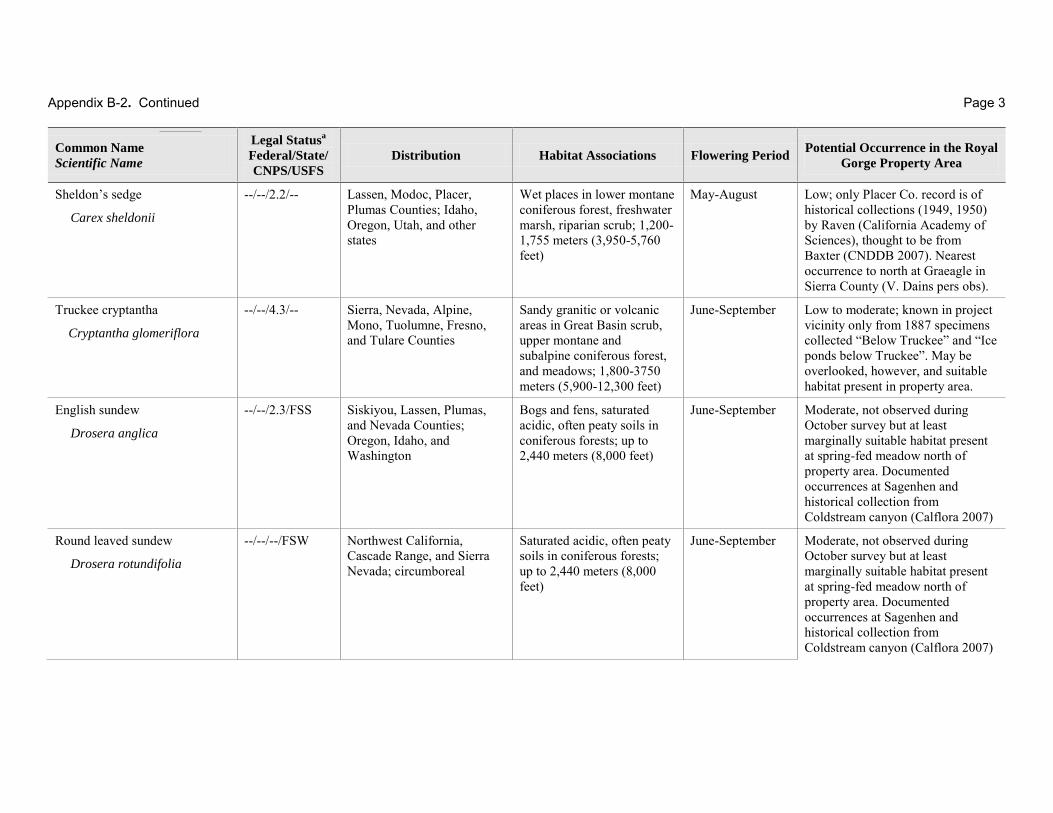
Appendix B-2. Continued Page 3
Common Name
Scientific Name
Legal Statusa
Federal/State/
CNPS/USFS
Distribution Habitat Associations Flowering Period Potential Occurrence in the Royal
Gorge Property Area
Sheldon’s sedge
Carex sheldonii
--/--/2.2/-- Lassen, Modoc, Placer, Plumas Counties; Idaho, Oregon, Utah, and other states
Wet places in lower montane coniferous forest, freshwater marsh, riparian scrub; 1,200-1,755 meters (3,950-5,760 feet)
May-August Low; only Placer Co. record is of historical collections (1949, 1950) by Raven (California Academy of Sciences), thought to be from Baxter (CNDDB 2007). Nearest occurrence to north at Graeagle in Sierra County (V. Dains pers obs).
Truckee cryptantha
Cryptantha glomeriflora
--/--/4.3/-- Sierra, Nevada, Alpine, Mono, Tuolumne, Fresno, and Tulare Counties
Sandy granitic or volcanic areas in Great Basin scrub, upper montane and subalpine coniferous forest, and meadows; 1,800-3750 meters (5,900-12,300 feet)
June-September Low to moderate; known in project vicinity only from 1887 specimens collected “Below Truckee” and “Ice ponds below Truckee”. May be overlooked, however, and suitable habitat present in property area.
English sundew
Drosera anglica
--/--/2.3/FSS Siskiyou, Lassen, Plumas, and Nevada Counties; Oregon, Idaho, and Washington
Bogs and fens, saturated acidic, often peaty soils in coniferous forests; up to 2,440 meters (8,000 feet)
June-September Moderate, not observed during October survey but at least marginally suitable habitat present at spring-fed meadow north of property area. Documented occurrences at Sagenhen and historical collection from Coldstream canyon (Calflora 2007)
Round leaved sundew
Drosera rotundifolia
--/--/--/FSW Northwest California, Cascade Range, and Sierra Nevada; circumboreal
Saturated acidic, often peaty soils in coniferous forests; up to 2,440 meters (8,000 feet)
June-September Moderate, not observed during October survey but at least marginally suitable habitat present at spring-fed meadow north of property area. Documented occurrences at Sagenhen and historical collection from Coldstream canyon (Calflora 2007)
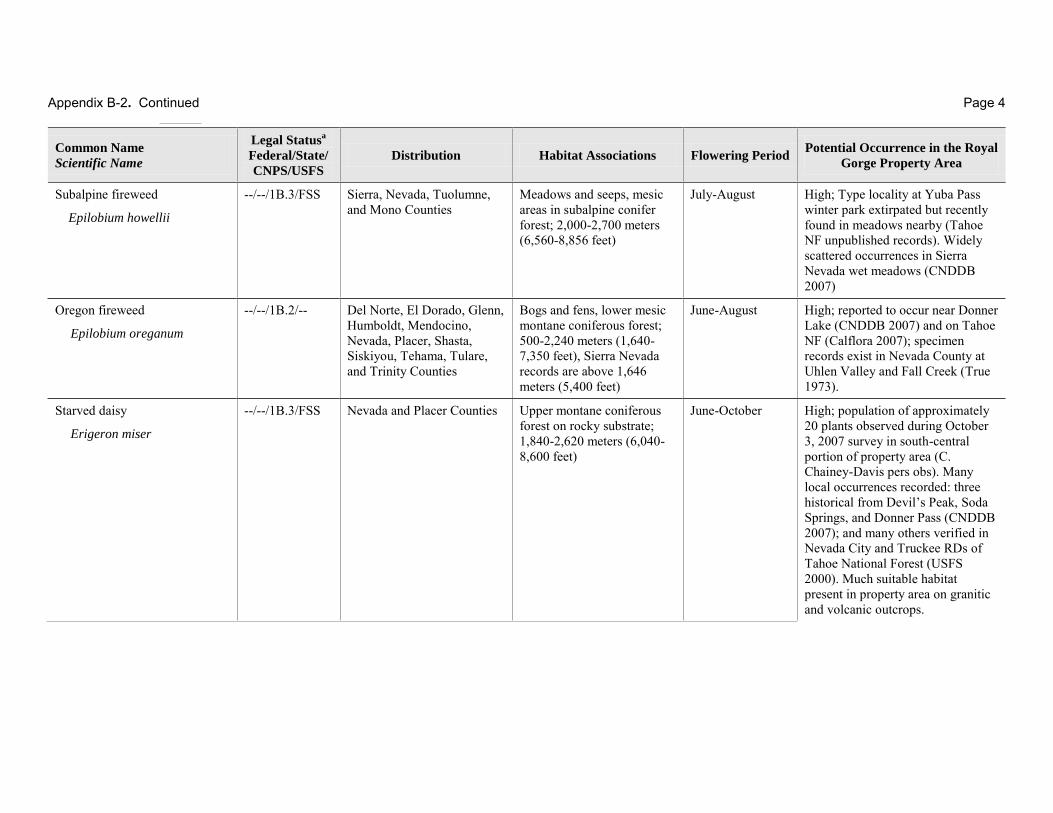
Appendix B-2. Continued Page 4
Common Name
Scientific Name
Legal Statusa
Federal/State/
CNPS/USFS
Distribution Habitat Associations Flowering Period Potential Occurrence in the Royal
Gorge Property Area
Subalpine fireweed
Epilobium howellii
--/--/1B.3/FSS Sierra, Nevada, Tuolumne, and Mono Counties
Meadows and seeps, mesic areas in subalpine conifer forest; 2,000-2,700 meters (6,560-8,856 feet)
July-August High; Type locality at Yuba Pass winter park extirpated but recently found in meadows nearby (Tahoe NF unpublished records). Widely scattered occurrences in Sierra Nevada wet meadows (CNDDB 2007)
Oregon fireweed
Epilobium oreganum
--/--/1B.2/-- Del Norte, El Dorado, Glenn, Humboldt, Mendocino, Nevada, Placer, Shasta, Siskiyou, Tehama, Tulare, and Trinity Counties
Bogs and fens, lower mesic montane coniferous forest; 500-2,240 meters (1,640-7,350 feet), Sierra Nevada records are above 1,646 meters (5,400 feet)
June-August High; reported to occur near Donner Lake (CNDDB 2007) and on Tahoe NF (Calflora 2007); specimen records exist in Nevada County at Uhlen Valley and Fall Creek (True 1973).
Starved daisy
Erigeron miser
--/--/1B.3/FSS Nevada and Placer Counties Upper montane coniferous forest on rocky substrate; 1,840-2,620 meters (6,040-8,600 feet)
June-October High; population of approximately 20 plants observed during October 3, 2007 survey in south-central portion of property area (C. Chainey-Davis pers obs). Many local occurrences recorded: three historical from Devil’s Peak, Soda Springs, and Donner Pass (CNDDB 2007); and many others verified in Nevada City and Truckee RDs of Tahoe National Forest (USFS 2000). Much suitable habitat present in property area on granitic and volcanic outcrops.

Appendix B-2. Continued Page 5
Common Name
Scientific Name
Legal Statusa
Federal/State/
CNPS/USFS
Distribution Habitat Associations Flowering Period Potential Occurrence in the Royal
Gorge Property Area
Donner Pass buckwheat
Eriogonum umbellatum var. torreyanum
--/--/1B.2/FSS Nevada, Placer, and Sierra Counties
Meadows, upper montane coniferous forest on volcanic, rocky substrate; 1,855-2,620 meters (6,100-8,600 feet)
July-September High; seven occurrences recorded, one extirpated (CNDDB 2007); many additional occurrences verified in Nevada City and Truckee RDs of Tahoe National Forest (USFS 2000) including Donner Pass area between old Hwy 40 and I-80, and ridge above Frog Lake. Suitable habitat present in open rocky barren areas, especially on volcanic substrates (USDA 1994).
American manna grass
Glyceria grandis
--/--/2.3/-- Humboldt, Mendocino, Mono, and Placer Counties; widespread outside of California
Bogs and fens, meadows, marshes on streambanks and at lake margins; 15-1,980 meters (50-6,500 feet)
June-August Moderate; one documented historical (1934) collection by Jepson from the Truckee River near Squaw Creek (CNDDB 2007). May be overlooked; suitable habitat present in marshes along Palisade Creek.
Amethyst stickseed
Hackelia amethystina
--/--/4.3/-- Trinity, Mendocino, Lassen, Tehama, Plumas, Lake, Glenn, and Placer Counties
Openings and disturbed areas in lower and upper montane conifer forest, meadows and seeps; 1,500-2,300 meters (4,920-7,544 feet)
June-July Low; known in Placer Co. only from 1912 collection at Deer Park. Range in Nevada County only implied in literature; no documented occurrences (Calflora 2007)
Plumas ivesia
Ivesia sericoleuca
--/--/1B.2/FSS Lassen, Nevada, Placer, Plumas, and Sierra Counties
Vernally mesic Great Basin scrub, lower montane coniferous forest, and meadows, vernal pools, usually volcanic substrate; 1,465-2,200 meters (4,800-7,200 feet)
May-September Low; three occurrences documented in Martis Valley (CNDDB 2007), verified in Truckee RD of Tahoe National Forest (USFS 2000) and all known occurrences on east side in vernal pools and vernally wet meadows in eastside scrub and forest.
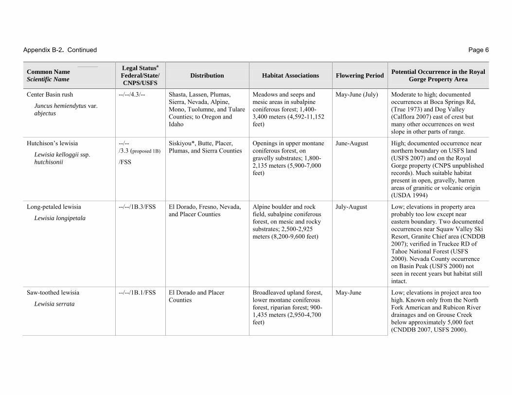
Appendix B-2. Continued Page 6
Common Name
Scientific Name
Legal Statusa
Federal/State/
CNPS/USFS
Distribution Habitat Associations Flowering Period Potential Occurrence in the Royal
Gorge Property Area
Center Basin rush
Juncus hemiendytus var. abjectus
--/--/4.3/-- Shasta, Lassen, Plumas, Sierra, Nevada, Alpine, Mono, Tuolumne, and Tulare Counties; to Oregon and Idaho
Meadows and seeps and mesic areas in subalpine coniferous forest; 1,400-3,400 meters (4,592-11,152 feet)
May-June (July) Moderate to high; documented occurrences at Boca Springs Rd, (True 1973) and Dog Valley (Calflora 2007) east of crest but many other occurrences on west slope in other parts of range.
Hutchison’s lewisia
Lewisia kelloggii ssp. hutchisonii
--/-- /3.3 (proposed 1B)
/FSS
Siskiyou*, Butte, Placer, Plumas, and Sierra Counties
Openings in upper montane coniferous forest, on gravelly substrates; 1,800-2,135 meters (5,900-7,000 feet)
June-August High; documented occurrence near northern boundary on USFS land (USFS 2007) and on the Royal Gorge property (CNPS unpublished records). Much suitable habitat present in open, gravelly, barren areas of granitic or volcanic origin (USDA 1994)
Long-petaled lewisia
Lewisia longipetala
--/--/1B.3/FSS El Dorado, Fresno, Nevada, and Placer Counties
Alpine boulder and rock field, subalpine coniferous forest, on mesic and rocky substrates; 2,500-2,925 meters (8,200-9,600 feet)
July-August Low; elevations in property area probably too low except near eastern boundary. Two documented occurrences near Squaw Valley Ski Resort, Granite Chief area (CNDDB 2007); verified in Truckee RD of Tahoe National Forest (USFS 2000). Nevada County occurrence on Basin Peak (USFS 2000) not seen in recent years but habitat still intact.
Saw-toothed lewisia
Lewisia serrata
--/--/1B.1/FSS El Dorado and Placer Counties
Broadleaved upland forest, lower montane coniferous forest, riparian forest; 900-1,435 meters (2,950-4,700 feet)
May-June Low; elevations in project area too high. Known only from the North Fork American and Rubicon River drainages and on Grouse Creek below approximately 5,000 feet (CNDDB 2007, USFS 2000).

Appendix B-2. Continued Page 7
Common Name
Scientific Name
Legal Statusa
Federal/State/
CNPS/USFS
Distribution Habitat Associations Flowering Period Potential Occurrence in the Royal
Gorge Property Area
Northern bugleweed
Lycopus uniflorus
--/--/4.3/-- Siskiyou, Shasta, Lassen, Del Norte*, Humboldt, Plumas, Nevada, Placer, and Tuolumne Counties; to Canada and eastern U.S.
Bogs and fens, marshes and swamps; 5-2,000 meters (16-6,560 feet)
July-September High; documented occurrence at Lake Valley Reservoir in Nevada County (Calflora 2007) and much suitable habitat present in property area
Three-ranked hump-moss
Meesia triquetra
--/--/4.2/FSS Siskiyou, Shasta, Lassen, Humboldt, Tehama, Butte, Plumas, Sierra, Nevada, Placer, Alpine, Mariposa, Madera, Fresno, Tulare, and Riverside Counties; circumpolar, circumboreal
Bogs and fens, wet meadows; wet areas in upper montane and subalpine conifer forest; 1,300-2953 meters (4,264-9,686 feet)
N/A Moderate to high, particularly in spring-fed portions of meadow north of property area but may also occur in wet meadow of the Royal Gorge property. Documented occurrences at Sagehen and other rich fens and spring-fed meadows to Independence Lake (Dillingham 2005). May be overlooked and occur elsewhere in region.
Broad-nerved hump-moss
Meesia uliginosa
--/--/2.2/FSS Siskiyou, Tehama, Plumas, Sierra, Nevada, Tulare, and Riverside Counties; circumpolar, circumboreal
Bogs and fens, wet meadows; wet areas in upper montane and subalpine conifer forest; 1,300-2953 meters (4,264-9,686 feet)
N/A Moderate to high, particularly in spring-fed portions of meadow north of property area but may also occur in wet meadows of the Royal Gorge propert. Documented occurrences at Sagehen and other rich fens and spring-fed meadows to Independence Lake (Dillingham 2005). May be overlooked and occur elsewhere in region.
Jones’s muhly
Muhlenbergia jonesii
--/--/4.3/-- Lassen, Mono, Modoc, Nevada, Placer, Plumas, Shasta, Siskiyou, and Trinity Counties
Lower and upper montane coniferous forest; 1,130-2,130 meters (3,700-7,000 feet)
June-August Moderate to high; known in area from 1881collection at Soda Springs (Calflora 2007) but may be overlooked. Also documented at Eagle Lakes (True 1973). Reported to occur in Placer County
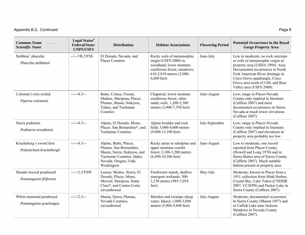
Appendix B-2. Continued Page 8
Common Name
Scientific Name
Legal Statusa
Federal/State/
CNPS/USFS
Distribution Habitat Associations Flowering Period Potential Occurrence in the Royal
Gorge Property Area
Stebbins’ phacelia
Phacelia stebbinsii
--/--/1B.2/FSS El Dorado, Nevada, and Placer Counties
Rocky soils of metamorphic origin (USFS 2000) in woodland, lower montane coniferous forest, meadows; 610-2,010 meters (2,000-6,600 feet)
June-July Low to moderate; no rock outcrops or soils of metamorphic origin in property area (USDA 1994). Area Documented occurrences in North Fork American River drainage in Cisco Grove quadrangle, Cisco Grove area north of I-80, and Bear Valley area (USFS 2000).
Coleman’s rein orchid
Piperia colemanii
--/--/4.3/-- Butte, Colusa, Fresno, Madera, Mariposa, Placer, Plumas, Shasta, Siskiyou, Tulare, and Tuolumne Counties
Chaparral, lower montane coniferous forest, often sandy soils; 1,200-2,300 meters (3,900-7,550 feet)
June-August Low; range in Placer-Nevada County only implied in literature (Calflora 2007) and most documented occurrences in Sierra Nevada at much lower elevations (Calflora 2007)
Sierra podistera
Podistera nevadensis
--/--/4.3/-- Alpine, El Dorado, Mono, Placer, San Bernardino*, and Tuolumne Counties
Alpine boulder and rock field; 3,000-4,000 meters (9,800-13,100 feet)
July-September Low; range in Placer-Nevada County only implied in literature (Calflora 2007) and elevations in property area probably too low
Kruckeberg’s sword fern
Polystichum kruckebergii
--/--/4.3/-- Alpine, Butte, Placer, Plumas, San Bernardino, Shasta, Sierra, Siskiyou, and Tuolumne Counties; Idaho, Nevada, Oregon, Utah, Washington
Rocky areas in subalpine and upper montane conifer forest; 2,100-3,200 meters (6,890-10,500 feet)
June-August Low to moderate; one record reported from Placer County (Howell and Long 1970) and in Sierra Buttes area of Sierra County (Calflora 2007). Much suitable habitat present in property area.
Slender-leaved pondweed
Potamogeton filiformis
--/--/2.2/FSW Lassen, Modoc, Sierra, El Dorado, Placer, Mono, Merced, Mariposa, Santa Clara*, and Contra Costa; circumboreal
Freshwater marsh, shallow emergent wetlands; 300-2,150 meters (985-7,054 feet)
May-July Moderate; known in Placer from a 1931 collection from Mink Harbor, Crystal Bay, Lake Tahoe (CNDDB 2007, UCJEPS) and Packer Lake in Sierra County (Calflora 2007).
White-stemmed pondweed
Potamogeton praelongus
--/--/2.3/-- Shasta, Sierra, Plumas, Nevada Counties; circumboreal
Marshes and swamps (deep water, lakes); 1,800-3,000 meters (5,904-9,840 feet)
July-August Moderate; documented occurrence in Sierra County (Mason 1957) and at Catfish Lake near Jackson Meadows in Nevada County (Calflora 2007).

Appendix B-2. Continued Page 9
Common Name
Scientific Name
Legal Statusa
Federal/State/
CNPS/USFS
Distribution Habitat Associations Flowering Period Potential Occurrence in the Royal
Gorge Property Area
Sierra starwort
Pseudostellaria sierrae
--/--/3.2/-- Nevada, Placer, El Dorado, Mariposa, and Tuolumne Counties
Chaparral, cismontane woodland, lower and upper montane conifer forest; 1,250-1,970 meters (4,100-6,462 feet)
May-August Moderate to high; Nevada County occurrences in Grouse Ridge area (Calflora 2007), known in Placer County from Junction Reservoir, expected to be more common (CNDDB 2005). Proposed as a CNPS 1B (CNDDB 2005)
White beaked-rush
Rhynchospora alba
--/--/2.2/-- Plumas, Nevada*, Mendocino, Mariposa*, and Inyo* Counties; circumboreal
Bogs and fens, meadows and seeps, marshes and swamps (freshwater); 60-2,040 meters (197-6,691 feet)
July-August Moderate to high; known in Nevada County from collection in Eagle Lakes area (True 1973). Suitable habitat present in spring-fed meadows north of property area and wet meadows of the Royal Gorge property.
Tahoe yellow cress
Rorippa subumbellata
C/E/1B.1/-- El Dorado, Nevada*, and Placer Counties
Lower montane coniferous forest, meadows on decomposed granitic beaches; 1,895-1,900 meters (6,217-6,233 feet)
May-September Low; known only from the shores of Lake Tahoe (CNDDB 2007); reported historic occurrences in Truckee area believed extirpated or erroneous (Pavlik et al 2002)
Water bulrush
Scirpus subterminalis
--/--/2.3/-- Del Norte, Shasta, Trinity, Lassen, Humboldt, Tehama, Butte, Plumas, Nevada, and El Dorado Counties; to Alaska and eastern U.S.
Bogs and fens, marshes and swamps (montane lake margins); 750-2,250 meters (2,460-7,380 feet)
May-September
(October)
Moderate to high; documented occurrence at Eagle Lakes (True 1973)

Appendix B-2. Continued Page 10
Common Name
Scientific Name
Legal Statusa
Federal/State/
CNPS/USFS
Distribution Habitat Associations Flowering Period Potential Occurrence in the Royal
Gorge Property Area
Marsh skullcap
Scutellaria galericulata
--/--/2.2/FSW El Dorado, Lassen, Modoc, Nevada, Placer, Plumas, Shasta, San Joaquin, and Siskiyou (?) Counties; circumboreal
Lower montane coniferous forest, mesic meadows, marshes; up to 2,100 meters (up to 6,900 feet)
June-September Moderate to high; known in Nevada County from 1885 collection at “Truckee River” (Calflora 2007), in Placer County from historical record from the vicinity of Truckee, exact location uncertain (CNDDB 2007, UCJEPS); also known from nearby El Dorado County in Tallac Creek and Meeks Creek near Lake Tahoe in Eldorado National Forest. Much suitable habitat present in meadows north of property area and in wet meadow north of Palisade Lake.
Small bur-reed
Sparganium natans
--/--/4.3/-- El Dorado, Lassen, Placer, Plumas, Shasta, and Tuolumne Counties; circumboreal
Bogs and fens, marshes at lake margins; 1,645-2,500 meters (5,400-8,200 feet)
July-August Moderate to high; collected at Kyburz Flat north of Truckee (Calflora 2007) and near Agate Bay, north end of Lake Tahoe (UCJEPS).
Munroe’s desert mallow
Sphaeralcea munroana
--/--/2.2/-- Placer County at Squaw Creek; Great Basin states
Great Basin scrub; 2,000 meters (6,560 feet)
May-June Low; known in California only from a 1922 collection from Squaw Creek, near Tahoe (CNDDB 2007)
Obtuse starwort
Stellaria obtusa
--/--/4.3/-- Shasta, Lassen, Tehama, Humboldt, Glenn, Plumas, Butte, Sierra, Nevada, and Tuolumne Counties; to British Columbia and east to Colorado and Montana
Riparian woodland, streambanks and mesic areas in lower and upper montane conifer forest; 150-2135 meters (492-7,003 feet)
May-September (October)
Moderate to high; Nevada County occurrences in Grouse Ridge area at Fall Creek (Calflora 2007); may be overlooked
Cusick’s speedwell
Veronica cusickii
--/--/4.3 /FSW Alpine, Amador, Madera, Mariposa, Placer, Sierra, and Tuolumne Counties; Oregon, Washington, and other states
Alpine boulder and rock field, meadows, subalpine coniferous forest, upper montane coniferous forest; 2,135-3,000 meters (7,000-9,800 feet)
July-August High; nearby occurrence in the North Fork American River drainage (Calflora 2007, Palmer et al. 1983) and collected near Granite Chief (UCJEPS). Suitable habitat present in property area.
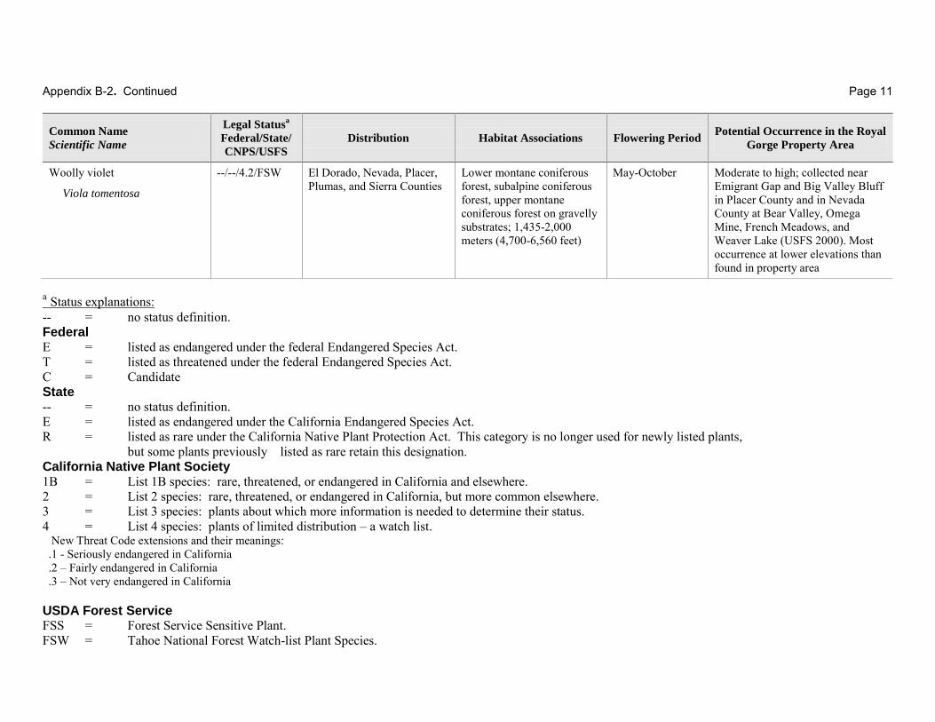
Appendix B-2. Continued Page 11
Common Name
Scientific Name
Legal Statusa
Federal/State/
CNPS/USFS
Distribution Habitat Associations Flowering Period Potential Occurrence in the Royal
Gorge Property Area
Woolly violet
Viola tomentosa
--/--/4.2/FSW El Dorado, Nevada, Placer, Plumas, and Sierra Counties
Lower montane coniferous forest, subalpine coniferous forest, upper montane coniferous forest on gravelly substrates; 1,435-2,000 meters (4,700-6,560 feet)
May-October Moderate to high; collected near Emigrant Gap and Big Valley Bluff in Placer County and in Nevada County at Bear Valley, Omega Mine, French Meadows, and Weaver Lake (USFS 2000). Most occurrence at lower elevations than found in property area
a Status explanations: -- = no status definition. Federal E = listed as endangered under the federal Endangered Species Act. T = listed as threatened under the federal Endangered Species Act. C = Candidate State -- = no status definition. E = listed as endangered under the California Endangered Species Act. R = listed as rare under the California Native Plant Protection Act. This category is no longer used for newly listed plants,
but some plants previously listed as rare retain this designation. California Native Plant Society 1B = List 1B species: rare, threatened, or endangered in California and elsewhere. 2 = List 2 species: rare, threatened, or endangered in California, but more common elsewhere. 3 = List 3 species: plants about which more information is needed to determine their status. 4 = List 4 species: plants of limited distribution – a watch list. New Threat Code extensions and their meanings: .1 - Seriously endangered in California .2 – Fairly endangered in California .3 – Not very endangered in California USDA Forest Service FSS = Forest Service Sensitive Plant. FSW = Tahoe National Forest Watch-list Plant Species.

Appendix B-2. Continued Page 12
References:
CalFlora: Information on California plants for education, research and conservation. [web application]. 2007. Berkeley, California: The CalFlora Database [a non-profit organization]. Available: http://www.calflora.org/
CNDDB - California Natural Diversity Database. 2007. RareFind 2, Version 2.1.2 (September 2007 update). Sacramento, CA: California Department of Fish and Game.
CNPS – California Native Plant Society. 2001. Inventory of rare and endangered plants of California (sixth edition). Rare Plant Scientific Advisory Committee, David P. Tibor, Convening Editor. Sacramento, CA: California Native Plant Society.
CNPS -- California Native Plant Society. 2004. Rare Plant Status Review: Pseudostellaria sierrae. Electronic memo from the Rare Plant Program of the California Native Plant Society and California Natural Diversity Data Base. June 28, 2004.
Dillingham, C. 2005. Conservation Assessment for Meesia triquetra and Meesia uliginosa in California with a focus on the Sierra Nevada Bioregion. VMS Enterprise Team, in cooperation with USDA Forest Service and the Nature Conservancy. May 2005.
Howell, J.T., and R.J. Long. 1970. The ferns and fern allies of the Sierra Nevada in California and Nevada. Four Seasons 3(3): 2-18.
Mason, H. 1957. A flora of the marshes of California.: University of California Press, Berkeley, CA, 878 pp.
Palmer, R., B.L. Corbin, R. Woodward, and M. Barbour. 1983. Floristic checklist for the Headwaters Basin area of the North Fork of the American River, Placer County, California. Madroño 30(4):Supplement:52–66.
Pavlik, B., et al. 2002. Conservation Strategy for Tahoe Yellow Cress (Rorippa subumbellata). Tahoe Regional Planning Agency. Lake Tahoe, NV
True, G. 1973. Ferns and Seed Plants of Nevada County, California. California Academy of Sciences. San Francisco, California. Plant Taxa, and Sensitive Plant Taxa; Vascular Plants and Cryptogams. San Francisco, CA.
UCJEPS - Specimens in the Jepson Herbarium. University of California. 2007. Names in the SMASCH database at UC/JEPS from Placer Co., California. Available online at http://www.mip.berkeley.edu:8080/servlet/SmaschAccession/tmp?taxon_name=&county=06061
USDA –U.S. Department of Agriculture. 2007. Who knew? Newly Delimited California Sensitive Plant Gains Protection from Rock Barrier and Informative Sign. USDA Forest Service Rangeland Management Botany Program. Washington D.C. Available:http://www.fs.fed.us/wildflowers/rareplants/conservation/success/lewisia_kelloggii_spp.shtml
USDA -- U.S. Department of Agriculture, Forest Service. 1994. Soil Survey, Tahoe National Forest. U.S. Department of Agriculture, Forest Service in cooperation with the USDA Soil Conservation Service.
USFS -- USDA Forest Service. 2000. Tahoe National Forest Sensitive Plant Program Standards and Guidelines
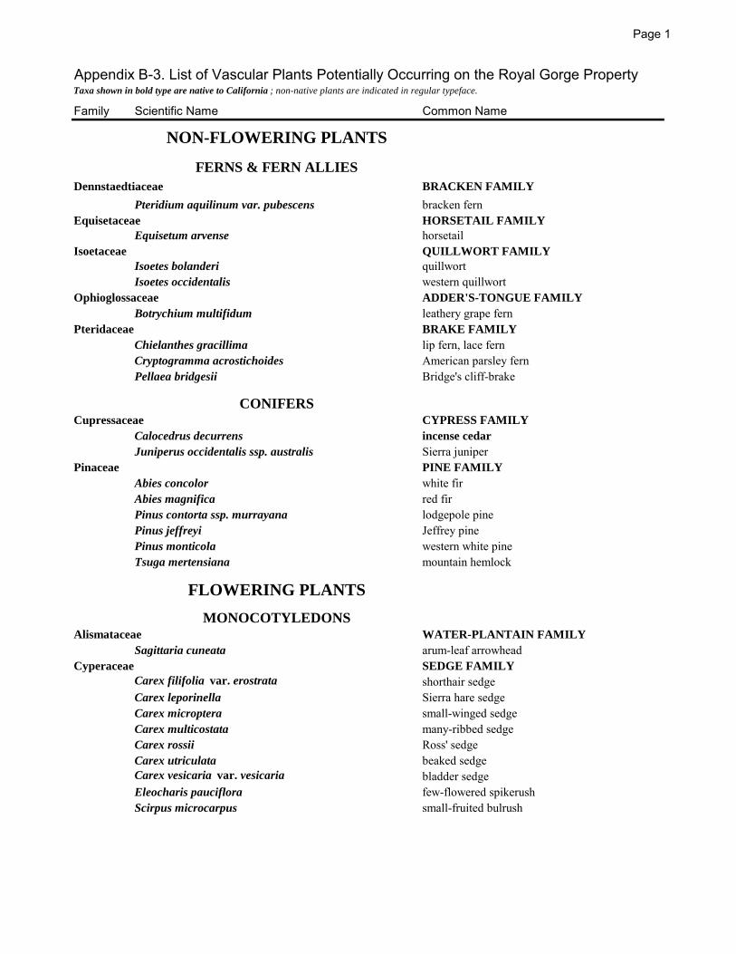
Page 1
Appendix B-3. List of Vascular Plants Potentially Occurring on the Royal Gorge PropertyTaxa shown in bold type are native to California ; non-native plants are indicated in regular typeface.
Family Scientific Name Common Name
NON-FLOWERING PLANTS
FERNS & FERN ALLIES
Dennstaedtiaceae BRACKEN FAMILY
Pteridium aquilinum var. pubescens bracken fernEquisetaceae HORSETAIL FAMILY
Equisetum arvense horsetailIsoetaceae QUILLWORT FAMILY
Isoetes bolanderi quillwortIsoetes occidentalis western quillwort
Ophioglossaceae ADDER'S-TONGUE FAMILY
Botrychium multifidum leathery grape fernPteridaceae BRAKE FAMILY
Chielanthes gracillima lip fern, lace fernCryptogramma acrostichoides American parsley fernPellaea bridgesii Bridge's cliff-brake
CONIFERSCupressaceae CYPRESS FAMILY
Calocedrus decurrens incense cedar
Juniperus occidentalis ssp. australis Sierra juniperPinaceae PINE FAMILY
Abies concolor white firAbies magnifica red firPinus contorta ssp. murrayana lodgepole pinePinus jeffreyi Jeffrey pinePinus monticola western white pineTsuga mertensiana mountain hemlock
FLOWERING PLANTS
MONOCOTYLEDONSAlismataceae WATER-PLANTAIN FAMILY
Sagittaria cuneata arum-leaf arrowheadCyperaceae SEDGE FAMILY
Carex filifolia var. erostrata shorthair sedgeCarex leporinella Sierra hare sedgeCarex microptera small-winged sedgeCarex multicostata many-ribbed sedgeCarex rossii Ross' sedgeCarex utriculata beaked sedgeCarex vesicaria var. vesicaria bladder sedgeEleocharis pauciflora few-flowered spikerushScirpus microcarpus small-fruited bulrush

Page 2
Family Scientific Name Common NameJuncaceae RUSH FAMILY
Juncus balticus Baltic rushJuncus ensifolius swordleaf rush, three-stemmed rushJuncus howellii Howell's rushJuncus nevadensis Sierra rushJuncus orthophyllus straightleaf rushJuncus parryi Parry rushLuzula subcongesta Donner woodrush
Liliaceae LILY FAMILY
Allium campanulatum Sierra onionCalochortus leichtlinii Leichtlin's mariposa lilyLilium parvum alpine lilyTriteleia ixioides ssp. anilina mountain prettyfaceVeratrum californicum var. californicum corn lily
Orchidaceae ORCHID FAMILY
Poaceae GRASS FAMILY
Achnatherum occidentale ssp. californicum California needlegrassAgrostis exarata spiked bentgrassAgrostis pallens leafy bentgrassAgrostis scabra ticklegrass, rough bentgrassAgrostis variabilis mountain bentgrassBromus carinatus var. carinatus California bromeBromus suksdorfii suksdorf bromeBromus tectorum cheatgrassCalamagrostis breweri shorthair reedgrassCalamagrostis canadensis bluejointCinna latifolia drooping wood reedDanthonia sp. oatgrassDeschampsia cespitosa ssp. cespitosa tufted hairgrassDeschampsia danthonioides annual hairgrassDeschampsia elongata slender hairgrassElymus elymoides ssp. elymoides squirreltailElymus glaucus ssp. glaucus blue WildryeHordeum brachyantherum ssp. brachyantherum meadow barleyMelica aristata awned melicMuhlenbergia richardsonis mat muhlyPanicum acuminatum var. acuminatum Pacific panic grassPoa fendleriana ssp. longilgula mutton grassPoa pratensis ssp. pratensis Kentucky bluegrassPoa sierrae Sierra blue grass
Potamogetonaceae PONDWEED FAMILY
Potamogeton sp. (P. natans? ) grass-leaved pondweedTyphaceae CATTAIL FAMILY
Sparganium sp. ? (S. emersum ?) narrowleaf bur-reed
DICOTYLEDONS
Aceraceae MAPLE FAMILY
Acer glabrum var. torreyi Torrey's mountain maple

Page 3
Family Scientific Name Common NameApiaceae CARROT FAMILY
Angelica breweri Brewer's angelicaCicuta douglasii western water hemlockCymopterus terebinthinus turpentine cymopterusHeracleum lanatum cow parsnipLigusticum grayi Gray's lovageOsmorhiza chilensis (syn. O. berteroi ) mountain sweet cicelyPeriderida bolanderi Bolander's yampahSanicula graveolens western sanicleSanicula tuberosa tuberous sanicle
Apocynaceae DOGBANE FAMILY
Apocynum androsaemifolium bitter dogbaneAsteraceae SUNFLOWER FAMILY
Achillea millefolium yarrowAgeratina occidentalis western eupatoriumAnaphalis margaritacea pearly everlastingAntennaria rosea ssp. confinis rosy pussytoesAster alpigenus var. andersonii ( syn. Oreostemma a. andersonii)alpine asterAster eatonii ( syn. Symphyotrichum eatonii) Eaton's asterAster integrifolius ( syn. Eurybia integrifolia ) entire-leaved asterCirsium andersonii anderson's thistleErigeron miser starved daisyEriophyllum lanatum var. integrifolium
Gnaphalium palustre western marsh cudweedHelianthella californica var. nevadensis California helianthellaHieracium albiflorum white-flowered hawkweedMadia minima dwarf madiaSenecio integerrimus tower butterweedSenecio integerrimus var. major lambstongue ragwortSenecio triangularis arrowhead butterweedSolidago canadensis ssp. elongata Canada goldenrodWyethia mollis woolly mule's-ears
Betulaceae BIRCH FAMILY
Alnus incana ssp. tenuifolia mountain alderBoraginaceae
Hackelia sp. stickseedBrassicaceae MUSTARD FAMILY
Arabis drummondii Drummond's rock-cressRorippa curvisiliqua western yellow cressStreptanthus tortuosus mountain jewelflower
Cabombaceae WATER-SHIELD FAMILY
Brasenia schreberi water shieldCaprifoliaceae HONEYSUCKLE FAMILY
Lonicera conjugialis double honeysuckleCaryophyllaceae PINK FAMILY
Arenaria kingii var. glabrescens (syn. Eremogone kingii ) King's smooth sandwortCornaceae DOGWOOD FAMILY
Cornus sericea ssp. sericea red twig dogwood

Page 4
Family Scientific Name Common NameCrassulaceae STONECROP FAMILY
Sedum obtusatum ssp. obtusatum Sierra stonecropEricaceae HEATH FAMILY
Arctostaphylos nevadensis pinemat manzanitaArctostaphylos patula greenleaf manzanitaLedum glandulosum western Labrador teaOrthilia secunda One-sided wintergreenPhyllodoce breweri Brewer's mountain heatherPterospora andromedea pine dropsPyrola asarifolia ssp. asarifolia bog wintergreenPyrola picta white-veined wintergreenSarcodes sanguinea snow plantVaccinium caespitosum dwarf bilberryVaccinium uliginosum ssp. occidentale western blueberry
Fabaceae LEGUME FAMILY
Lupinus sp. (L. fulcratus ?) lupineLupinus polyphyllus var. burkei meadow lupineTrifolium longipes long-stalked clover
Fagaceae OAK FAMILY
Quercus vaccinifolia huckleberry OakGeraniaceae GERANIUM FAMILY
Geranium richardsonii Richardson's geraniumGrossulariaceae GOOSEBERRY FAMILY
Ribes roezlii var. roezlii Sierra gooseberryRibes viscosissimum var. Hallii sticky currant
Haloragaceae WATER-MILFOIL FAMILY
Myriophyllum sibiricum Siberian water-milfoilHydrophyllaceae WATERLEAF FAMILY
Nama lobbii Lobb's namaPhacelia hastata ssp. compacta timberline phaceliaPhacelia hydrophylloides waterleaf phacelia
Hypericaceae ST. JOHN'S WORT FAMILY
Hypericum anagalloides Tinker's pennyLamiaceae MINT FAMILY
Agastache urticifolia horse-mintMonardella odoratissima ssp. pallida pallid mountain monardellaScutellaria californica California skullcap
Malvaceae MALLOW FAMILY
Sidalcea glaucescens glaucous checker-mallowSidalcea oregana ssp. spicata Oregon checker mallow
Nympaeaceae WATERLILY FAMILY
Nuphar luteum ssp. polysepalum cow lily, yellow pond-lilyOnagraceae EVENING-PRIMROSE FAMILY
Epilobium angustifolium ssp. circumvagum fireweedEpilobium canum ssp. latifolium California fuchsiaEpilobium ciliatum ssp. ciliatum fringed willow herbEpilobium oregonense Oregon willow herbGayophytum sp. groundsmoke

Page 5
Family Scientific Name Common NamePolemoniaceae PHLOX FAMILY
Linanthus ciliatus whisker brushPhlox diffusa spreading phloxPolemonium californicum Jacob's ladder, California polemonium
Polygonaceae BUCKWHEAT FAMILY
Eriogonum lobbii var. lobbii Lobb's buckwheatEriogonum umbellatum var. polyanthum many-flowered sulfur buckwheatEriogonum wrightii ssp. subscaposum Wright's buckwheatPolygonum douglasii Douglas' knotweedPolygonum phytolaccifolium alpine knotweedRumex salicifolius triangular-fruited dock
Portulacaceae PURSLANE FAMILY
Calyptridium umbellatum pussypawsLewisia kelloggii ssp. hutchisonii Hutchison's lewisia
Ranunculaceae BUTTERCUP FAMILY
Aconitum columbianum monkshoodAquilegia formosa western columbineRanunculus aquatilus var. capillaceus water buttercupThalictrum fendleri Fendler's meadow rue
Rhamnaceae BUCKTHORN FAMILY
Ceanothus cordulatus mountain whitethornRosaceae ROSE FAMILY
Amelanchier utahensis pale-leaved serviceberryHolodiscus microphyllus var. microphyllus rock spiraea, little-leaf creambushHorkelia fusca dusky horkeliaPotentilla glandulosa ssp. nevadensis Nevada cinquefoilPotentilla gracilis five-finger cinquefoilPrunus emarginata bitter cherryRubus parviflorus thimbleberrySpiraea densiflora mountain spiraea
Rubiaceae MADDER FAMILY
Galium triflorum sweet-scented bedstrawSalicaceae WILLOW FAMILY
Populus balsamifera ssp. trichocarpa black cottonwoodPopulus tremuloides quaking aspenSalix lemmonii Lemmon's willowSalix scouleriana Scouler's willow
Saxifragaceae SAXIFRAGE FAMILY
Heuchera rubescens var. glandulosa pink alumrootSaxifraga sp. (S. oregana or bryophora ?) streambank saxifrage
Scrophulariaceae FIGWORT FAMILY
Castilleja sp. paintbrushMimulus guttatus (or M. tillingii ?) seep-spring monkeyflowerMimulus primuloides primrose monkeyflowerPedicularis attollens little elephants headPedicularis semibarbata dwarf lousewort, pinewoods lousewortPenstemon azureus azure penstemonPenstemon newberryi var. newberryi mountain pride, Newberry's penstemonPenstemon rydbergii var. oreocharis meadow penstemon, Rydberg's penstemon
Violaceae VIOLET FAMILY
Viola adunca western dog violetViscaceae MISTLETOE FAMILY
Arceuthobium abietinum fir dwarf mistletoe

Appendix B-4. Vertebrate Species with Known or Potential Occurrence at the Royal
Gorge Property, Nevada and Placer counties, CA. (See footnote at bottom for the
status codes).
Family/Common Name Scientific Name
FISHES
Trout (Salmonidae)
Rainbow Trout (I) Oncorhynchus mykiss irideus
Brown Trout (I) Salmo trutta
Eastern Brook Trout (I) Salvelinus fontinalis
Yellow Perch (I) Perca flavescens
Bullhead Catfish (I) Ameiurus sp. AMPHIBIANS
True Toads (Bufonidae)
Western Toad Bufo boreas
Chorus Frogs (Hylidae)
Pacific Chorus Frog Pseudacris regilla
True Frogs (Ranidae)
Sierra Nevada Yellow-legged Frog (?) Rana sierrae
Mole Salamanders (Ambystomidae)
Long-toed Salamander (?) Ambystoma macrodactylum REPTILES
Iguanids (Phrynosomatidae)
Western Fence Lizard Sceloporus occidentalis
Skinks (Scincidae)
Western Skink (?) Eumeces skiltonianus
Boas (Boidae)
Rubber Boa Charina bottae
Colubrids (Colubridae)
Gopher Snake Pituophis melanoleucus
California Mountain Kingsnake (?) Lampropeltis zonata
Common Garter Snake (?) Thamnophis sirtalis
Western Terrestrial Garter Snake Thamnophis elegans
Western Aquatic Garter Snake Thamnophis couchi
Vipers (Viperidae)
Western Rattlesnake (?) Crotalus viridis
BIRDS
Waterfowl (Anatidae)
Canada Goose Branta canadensis
Mallard Anas platyrhynchos
Ring-necked Duck Aythya collaris
Bufflehead Bucephala albeola
Common Goldeneye Bucephala clangula
Common Merganser Mergus merganser
Quail (Odontophoridae)
Mountain Quail Oreortyx pictus

Appendix B-4. Continued Page 2
Family/Common Name Scientific Name
Grouse (Phasianidae)
Sooty Grouse Dendragapus fuliginosus
Herons and Egrets (Ardeidae)
Great Blue Heron Ardea herodias
Great Egret (?) Ardea alba
New World Vultures (Cathartidae)
Turkey Vulture Cathartes aura
Osprey (Pandionidae)
Osprey Pandion haliaetus
Hawk and Eagles (Accipitridae)
Bald Eagle Haliaeetus leucocephalus
Sharp-shinned Hawk Accipiter striatus
Cooper's Hawk Accipiter cooperii
Northern Goshawk Accipiter gentilis
Red-tailed Hawk Buteo jamaicensis
Golden Eagle Aquila chrysaetos
Falcons (Falconidae)
American Kestrel Falco sparverius
Merlin Falco columbarius
Peregrine Falcon Falco peregrinus
Prairie Falcon Falco mexicanus
Plovers (Charadriidae)
Killdeer Charadrius vociferus
Sandpipers (Scolopacidae)
Spotted Sandpiper Actitis macularia
Pigeons (Columbidae)
Band-tailed Pigeon Columba fasciata
Typical Owls (Strigidae)
Western Screech-Owl (?) Megascops kennicottii
Great Horned Owl Bubo virginianus
Northern Pygmy-Owl (?) Glaucidium gnoma
Spotted Owl (?) Strix occidentalis
Northern Saw-Whet Owl (?) Aegolius acadicus
Nighthawks (Caprimulgidae)
Common Nighthawk Chordeiles minor
Common Poorwill (?) Phalaenoptilus nuttallii
Swifts (Apodidae)
Black Swift (?) Cypseloides niger
Vaux's Swift Chaetura vauxi
White-throated Swift Aeronautes saxatalis
Hummingbirds (Trochilidae)
Anna's Hummingbird Calypte anna
Calliope Hummingbird Stellula calliope
Rufous Hummingbird Selasphorus rufus
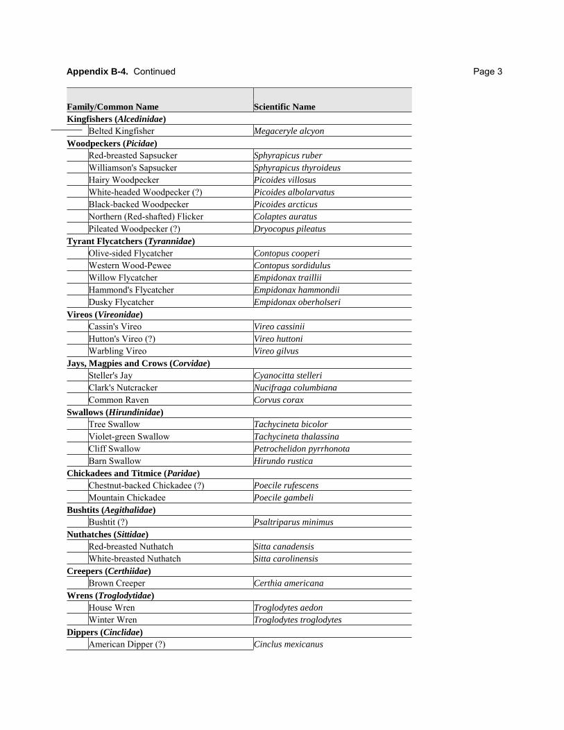
Appendix B-4. Continued Page 3
Family/Common Name Scientific Name
Kingfishers (Alcedinidae)
Belted Kingfisher Megaceryle alcyon
Woodpeckers (Picidae)
Red-breasted Sapsucker Sphyrapicus ruber
Williamson's Sapsucker Sphyrapicus thyroideus
Hairy Woodpecker Picoides villosus
White-headed Woodpecker (?) Picoides albolarvatus
Black-backed Woodpecker Picoides arcticus
Northern (Red-shafted) Flicker Colaptes auratus
Pileated Woodpecker (?) Dryocopus pileatus
Tyrant Flycatchers (Tyrannidae)
Olive-sided Flycatcher Contopus cooperi
Western Wood-Pewee Contopus sordidulus
Willow Flycatcher Empidonax traillii
Hammond's Flycatcher Empidonax hammondii
Dusky Flycatcher Empidonax oberholseri
Vireos (Vireonidae)
Cassin's Vireo Vireo cassinii
Hutton's Vireo (?) Vireo huttoni
Warbling Vireo Vireo gilvus
Jays, Magpies and Crows (Corvidae)
Steller's Jay Cyanocitta stelleri
Clark's Nutcracker Nucifraga columbiana
Common Raven Corvus corax
Swallows (Hirundinidae)
Tree Swallow Tachycineta bicolor
Violet-green Swallow Tachycineta thalassina
Cliff Swallow Petrochelidon pyrrhonota
Barn Swallow Hirundo rustica
Chickadees and Titmice (Paridae)
Chestnut-backed Chickadee (?) Poecile rufescens
Mountain Chickadee Poecile gambeli
Bushtits (Aegithalidae)
Bushtit (?) Psaltriparus minimus
Nuthatches (Sittidae)
Red-breasted Nuthatch Sitta canadensis
White-breasted Nuthatch Sitta carolinensis
Creepers (Certhiidae)
Brown Creeper Certhia americana
Wrens (Troglodytidae)
House Wren Troglodytes aedon
Winter Wren Troglodytes troglodytes
Dippers (Cinclidae)
American Dipper (?) Cinclus mexicanus

Appendix B-4. Continued Page 4
Family/Common Name Scientific Name
Kinglets (Regulidae)
Golden-crowned Kinglet Regulus satrapa
Ruby-crowned Kinglet Regulus calendula
Thrushes (Turdidae)
Western Bluebird (?) Sialia mexicana
Mountain Bluebird Sialia currucoides
Townsend's Solitaire Myadestes townsendi
Hermit Thrush Catharus guttatus
American Robin Turdus migratorius
Varied Thrush (?) Ixoreus naevia
Wood-Warblers (Parulidae)
Orange-crowned Warbler Oreothlypis celata
Nashville Warbler Oreothlypis ruficapilla
Yellow Warbler Setophaga petechia
Yellow-rumped Warbler Setophaga coronata
Black-throated Gray Warbler Setophaga nigrescens
Townsend's Warbler Setophaga townsendi
Hermit Warbler Setophaga occidentalis
Wilson's Warbler Cardellina pusilla
Towhees and Sparrows (Emberizidae)
Green-tailed Towhee Pipilo chlorurus
Spotted Towhee Pipilo maculatus
Chipping Sparrow Spizella passerina
Fox Sparrow Passerella iliaca
Song Sparrow Melospiza melodia
Mountain White-crowned Sparrow Zonotrichia leucophrys oriantha
Dark-eyed Junco Junco hyemalis
Tanagers, Grosbeaks, and Buntings (Cardinalidae)
Western Tanager Piranga ludoviciana
Black-headed Grosbeak Pheucticus melanocephalus
Lazuli Bunting (?) Passerina amoena
Blackbirds and Relatives (Icteridae)
Red-winged Blackbird Agelaius phoeniceus
Western Meadowlark Sturnella neglecta
Brown-headed Cowbird Molothrus ater
Bullock’s Oriole (?) Icterus bullockii
Finches (Fringillidae)
Pine Grosbeak Pinicola enucleator
Purple Finch Carpodacus purpureus
Cassin’s Finch Carpodacus cassinii
Red Crossbill Loxia curvirostra
Pine Siskin Spinus pinus
Lesser Goldfinch (?) Spinus psaltria
Evening Grosbeak Coccothraustes vespertinus

Appendix B-4. Continued Page 5
Family/Common Name Scientific Name
MAMMALS
Shrews (Soricidae)
Vagrant Shrew Sorex vagrans
Trowbridge’s Shrew (?) Sorex trowbridgii
Water Shrew (?) Sorex palustris
Moles (Talpidae)
Broad-footed Mole Scapanus latimanus
Vespertilionid Bats (Vespertilionidae)
Little Brown Myotis (?) Myotis lucifugus
California Myotis ( ?) Myotis californicus
Yuma Myotis ( ?) Myotis yumanensis
Long-eared Myotis (?) Myotis evotis
Fringed Myotis (?) Myotis thysanodes
Big Brown Bat (?) Eptesicus fuscus
Hoary Bat (?) Lasiurus cinereus
Pikas (Ochotonidae)
Pika (?) Ochotona princeps
Rabbits (Leporidae)
Snowshoe Hare Lepus americanus
Mountain Beaver (Aplodontidae)
Sierra Nevada Mountain Beaver (?) Aplodontia rufa californica
Squirrels, Chipmunks and Marmots (Sciuridae)
Yellow-pine Chipmunk (?) Tamias amoenus
Allen’s Chipmunk (?) Tamias senex
Long-eared Chipmunk (?) Tamias quadrimaculatus
Lodgepole Chipmunk Tamias speciosus
Yellow-bellied Marmot Marmota flaviventris
California Ground Squirrel Spermophilus beecheyi
Golden-mantled Ground Squirrel Spermophilus lateralis
Douglas' Squirrel Tamiasciurus douglasii
Northern Flying Squirrel Glaucomys sabrinus
Pocket Gophers (Geomyidae)
Mountain Pocket Gopher Thomomys monticola
Mice, Voles, and relatives (Cricetidae)
Brush Mouse Peromyscus boylii
Deer Mouse Peromyscus maniculatus
Bushy-tailed Woodrat Neotoma cinerea
Montane Vole Microtus montanus
Jumping Mice (Zapodidiae)
Western Jumping Mouse (?) Zapus princeps
New World Porcupines (Erethizontidae)
Porcupine Erethizon dorsatum
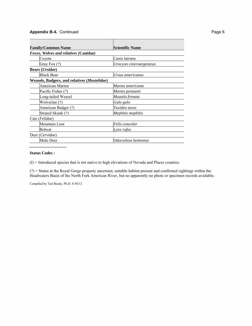
Appendix B-4. Continued Page 6
Family/Common Name Scientific Name
Foxes, Wolves and relatives (Canidae)
Coyote Canis latrans
Gray Fox (?) Urocyon cineroargenteus
Bears (Ursidae)
Black Bear Ursus americanus
Weasels, Badgers, and relatives (Mustelidae)
American Marten Martes americana
Pacific Fisher (?) Martes pennanti
Long-tailed Weasel Mustela frenata
Wolverine (?) Gulo gulo
American Badger (?) Taxidea taxus
Striped Skunk (?) Mephitis mephitis
Cats (Felidae) Mountain Lion Felis concolor
Bobcat Lynx rufus
Deer (Cervidae) Mule Deer Odocoileus hemionus Status Codes :
(I) = Introduced species that is not native to high elevations of Nevada and Placer counties. (?) = Status at the Royal Gorge property uncertain; suitable habitat present and confirmed sightings within the Headwaters Basin of the North Fork American River, but no apparently no photo or specimen records available. Compiled by Ted Beedy, Ph.D. 8/30/12
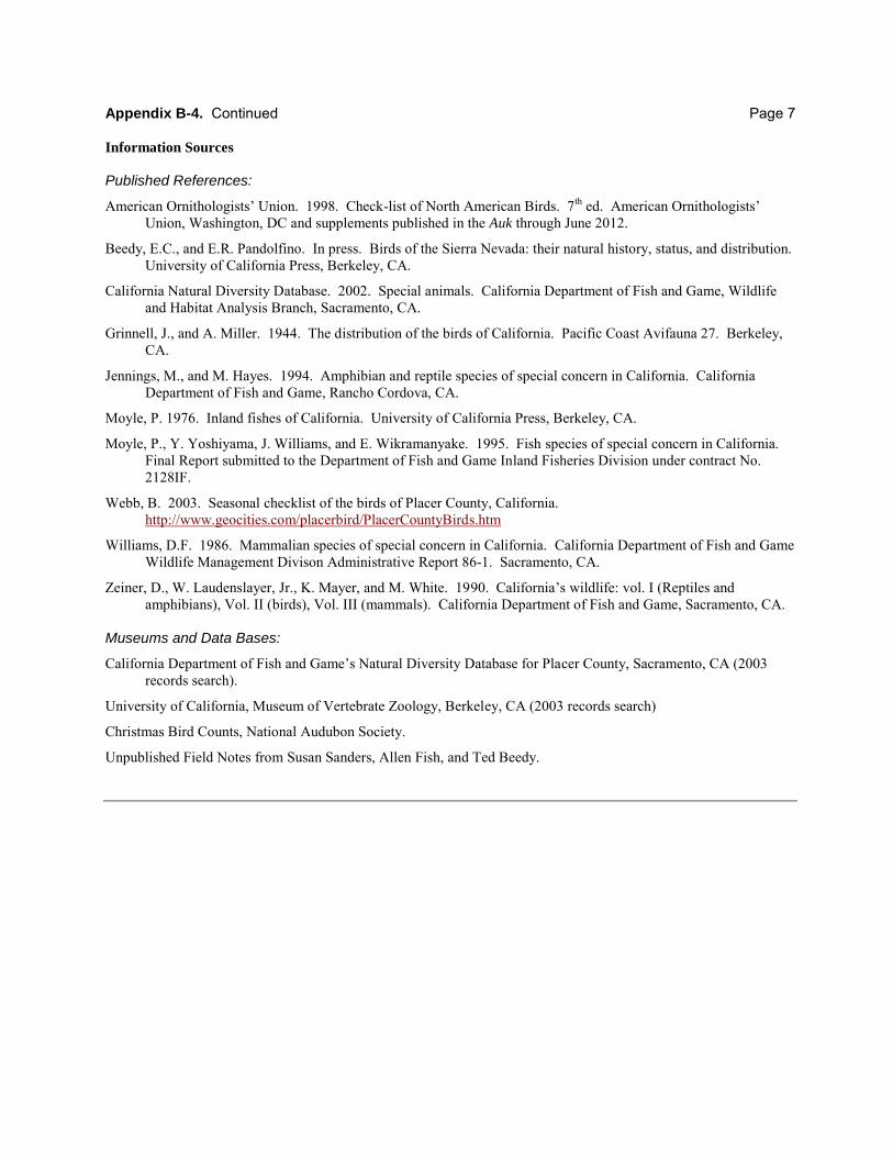
Appendix B-4. Continued Page 7 Information Sources
Published References:
American Ornithologists’ Union. 1998. Check-list of North American Birds. 7th ed. American Ornithologists’ Union, Washington, DC and supplements published in the Auk through June 2012.
Beedy, E.C., and E.R. Pandolfino. In press. Birds of the Sierra Nevada: their natural history, status, and distribution. University of California Press, Berkeley, CA.
California Natural Diversity Database. 2002. Special animals. California Department of Fish and Game, Wildlife and Habitat Analysis Branch, Sacramento, CA.
Grinnell, J., and A. Miller. 1944. The distribution of the birds of California. Pacific Coast Avifauna 27. Berkeley, CA.
Jennings, M., and M. Hayes. 1994. Amphibian and reptile species of special concern in California. California Department of Fish and Game, Rancho Cordova, CA.
Moyle, P. 1976. Inland fishes of California. University of California Press, Berkeley, CA.
Moyle, P., Y. Yoshiyama, J. Williams, and E. Wikramanyake. 1995. Fish species of special concern in California. Final Report submitted to the Department of Fish and Game Inland Fisheries Division under contract No. 2128IF.
Webb, B. 2003. Seasonal checklist of the birds of Placer County, California. http://www.geocities.com/placerbird/PlacerCountyBirds.htm
Williams, D.F. 1986. Mammalian species of special concern in California. California Department of Fish and Game Wildlife Management Divison Administrative Report 86-1. Sacramento, CA.
Zeiner, D., W. Laudenslayer, Jr., K. Mayer, and M. White. 1990. California’s wildlife: vol. I (Reptiles and amphibians), Vol. II (birds), Vol. III (mammals). California Department of Fish and Game, Sacramento, CA.
Museums and Data Bases:
California Department of Fish and Game’s Natural Diversity Database for Placer County, Sacramento, CA (2003 records search).
University of California, Museum of Vertebrate Zoology, Berkeley, CA (2003 records search)
Christmas Bird Counts, National Audubon Society.
Unpublished Field Notes from Susan Sanders, Allen Fish, and Ted Beedy.