Embed Size (px)
Citation preview

8/2/2019 Connectivity Challenge Report
http://slidepdf.com/reader/full/connectivity-challenge-report 1/20
The Connectivity ChallengeDecember 8-10, 2010

8/2/2019 Connectivity Challenge Report
http://slidepdf.com/reader/full/connectivity-challenge-report 2/20ofbyandforus.org
The US Initiative is brought to you by
WITH GENEROUS SUPPORT FROM THE ROCKEFELLER FOUNDATION
Imagine a community taking up the challenge to ensure its citizens
are able to meet their daily needs without owning a car. Where
every convenience is within a short walk, bike ride, car-share or transit trip.
Now imagine we could realize that future here and now. What would thatlook like? What would be an effective quick start strategy? Where are the
early wins to create momentum? And how would a community know when
it is succeeding?
Seventy years ago GM’s Futurama generated a
compelling vision for a new American ideal: a
spacious, car-centered good life. That ideal dominatedpublic policy for 50 years, literally paving the way for
Americans to spread out by increasing homebuyers’
access to credit and supporting development patterns
that relied on cheap land and cheap gas.
We are beginning to see that while sprawling
suburbanization made sense for a time, Americans
have a growing appetite for urban living. The places
that thrive today are those with the highest velocity
of ideas and the highest density of talented people.
We know that 25-34 year-olds have shown an
increasing propensity to live with a 3-mile radius
of central business districts and by 2000 were 33%
more likely than other Americans to live in close-in
neighborhoods that are compact, multi-functional
(thanks to a mix of uses) and oer alternatives to the
car as a way to get around.
Planners now project that 86% of the growth in new
households will be single people or couples without
children at home – and neither group wants to live in
remote suburbs or in houses surrounded by big lawns.
Four cars in every garage may have once been the
dream of Americans, but it’s now clear that not only
is that time-consuming and isolating; not only does itundermine the natural advantages of cities, but it is
also expensive.
A key advantage of cities is their intrinsi
sustainability: they require less car travel, use less
energy and generate fewer emissions per capita
than more sprawling areas. Alternative forms of
transportation (transit, walking and cycling) enable
city-dwellers to recapture income otherwise spent
on cars and gasoline – money that quickly leaves
the local economy – and redistribute it in their local
economies.
CEOs for Cities has calculated that by reducing
vehicle miles traveled by one mile per person per
day in the nation’s top 51 metro areas, the U.S. could
realize a $29 billion “Green Dividend.” Therefore, a
critical strategy for promoting true sustainability—
environmental and economic—is to reduce vehicle
miles traveled. And the best way to reduce vehicle
miles traveled is through genuine urbanism.

8/2/2019 Connectivity Challenge Report
http://slidepdf.com/reader/full/connectivity-challenge-report 3/20ofbyandforus.org
The US Initiative is brought to you by
WITH GENEROUS SUPPORT FROM THE ROCKEFELLER FOUNDATION
On December 8-10, 2010, CEOs for Cities convenedthe Connectivity Challenge in Chicago. A team of international connectivity experts led by Jan Gehl,together with the City of Chicago, Chicago Transit Authority, Chicago Metropolitan Agency for Planning and other regional transportation stakeholders, workedover 2.5 days to imagine a future for Chicago in whichits residents can meet their daily needs without owning a car. The Connectivity Challenge team included:
National Experts
Jan Gehl, Architect, Principal and Partner, Gehl Architects (Copenhagen, Denmark)Oscar Edmundo Diaz, Co-founder and President, GSDPlus (Bogota, Colombia)Doug Farr, President and CEO, Farr Associates Architecture & Urban Design (Chicago)Peter Kindel, Director of Urban Design, Adrian Smith +Gordon Gill Architecture (Chicago)Scott Stowell, Proprietor, OPEN (New York City)Harriet Tregoning, Director, District of Columbia
Oce of Planning (Washington, DC)Susan Zielinski, Managing Director, SMART,University of Michigan (Ann Arbor, MI)
Local Stakeholders
Ron Burke, Executive Director, Active Transportation AllianceRandy Blankenhorn, Executive Director, ChicagoMetropolitan Agency for Planning Erin Lavin Cabonargi, Executive Director, PublicBuilding CommissionJoe Costello, Acting Executive Director, Regional
Transportation Authority Luann Hamilton, Deputy Commissioner, ChicagoDepartment of TransportationTom McKone, Principal, Civic Consulting AllianceTerry Peterson, Chairman, Chicago Transit Authority Ruth Wuorenma, Chair and President, NeighborhoodCapital Institute
B I G I D E A S are needed for any city to achieve the ambition of making it
possible for its citizens to meet their daily needs without owning a car. The goal of
the Connectivity Challenge was to generate those Big Ideas using a set of guiding
principles, tactics and demonstration projects that provide an actionable and
compelling framework for achieving the Connectivity ambition.Using a methodology developed by Charlie Cannon Associate Professor and Founder of the InnovatioStudio at the Rhode Island School of Design, the teamidentied critical components of the Connectivityambition:
We can go where we need to go without owning a car.
The Big Ideas may be thought of as dierent lensesfor understanding how to achieve the ambitionthrough which specic projects identied by our keystakeholders can be viewed. In eect, these projectsare expressions of the Big Ideas. So while Chicago wasthe laboratory for exploring Big Ideas, the strategiesidentied in this report are both locally relevant andnationally signicant.
The Connectivity Challenge is one of ve nationalchallenges staged by CEOs for Cities as part of theUS Initiative, an ambitious movement by CEOs forCities’ national network of civic leaders, inuential
partners and brave new thinkers to dene a new American Dream. The project articulates a Declarationof Interdependence with values that dene cities oftomorrow, today.
The following pages reveal 12 Big Ideas that emergedfrom the Connectivity Challenge, as well as specicstrategies for executing them locally.
Results of the Connectivity Challenge will be put to usein national publications related to the US Initiativeincluding a book to be published by The Rockefeller
Foundation.

8/2/2019 Connectivity Challenge Report
http://slidepdf.com/reader/full/connectivity-challenge-report 4/20ofbyandforus.org
The US Initiative is brought to you by
WITH GENEROUS SUPPORT FROM THE ROCKEFELLER FOUNDATION
1. DESIGN FOR PEOPLE, NOT CARS
The urban environment can be viewed at three scales– the city plan scale (airplane view), the site plan scale(rooftop view) and the human scale (view at eye level).The human scale provides small spaces and smallsignals that allow us to experience the details of peopleand places. The human scale is best navigated at speedsof approximately 3 miles per hour, but today’s cities areplanned for navigating at speeds in excess of 35 milesper hour, thus de-valuing the pedestrian experience.Put simply, cities must shift their planning and designfocus from cars and large transportation infrastructure
to the human scale of the city.
STRATEGY: DEPARTMENT OF PUBLIC LIFE All cities have trac departments and detailed statisticsconcerning trac and parking. This results from making cars very visible and ever-present in urban planning processes. People, by contrast, tend to be invisible andpoorly represented. Are there any major U.S. cities with
We know more about the mountain habitat of gorillas than we do about
the urban environment for humans. – Enrique Peñalosa
departments dedicated to pedestrians and public life?New urban indicators are needed to capture humandensity and activity. Such data would facilitate a betterunderstanding of where investments should be made toimprove and enliven public life.

8/2/2019 Connectivity Challenge Report
http://slidepdf.com/reader/full/connectivity-challenge-report 5/20ofbyandforus.org
The US Initiative is brought to you by
WITH GENEROUS SUPPORT FROM THE ROCKEFELLER FOUNDATION
2. CONNECT AND LEVERAGE PUBLICASSETS TO ADD VALUE TONEIGHBORHOODS
All public investments should be made to spur additional
investment and increase neighborhood value.
When designing and selecting sites for its public facilities, a city ought to link schools, libraries and recreation centers totransportation hubs to create additional value for neighborhoodsas “complete communities” and spur private investment. Transitstops and schools, for instance, are generally highly stable assetsand can be used to leverage private investment, just as colleges anduniversities are now doing in cities across the country. The positive
economic impact of these kinds of so-called “anchor institutions” onthe surrounding neighborhoods increases dramatically when leadersof anchor institutions decide to focus attention on the community,assign resources to it and stop surrounding their campuses withbarriers to the rest of the community, such as parking lots and garages,substituting instead uses of broader appeal such as bookstores and artgalleries. The Neighborhood Capital Institute has been examining how transit stops, schools and other public assets can be used moreeectively as anchors of cohesive neighborhoods that are attractiveto new residents and other desired new investment alike.
STRATEGY: TRANSIT-ENHANCED DISTRICTS
The Neighborhood Capital Institute makes a strong argument forthe urban village anchored by transit (and schools, parks, librairies),or Transit-Enhanced Districts, by suggesting a 100-120 block scale(a typical transit zone size), for creating a bikable, walkable urbanenvironment. Transit-Enhanced Districts layer transit onto existing or planned public real estate assets so that each district becomesan accessible hub, oering a full range of attractive uses, thusleveraging public investment and creating value. At the urban villagescale, people can take transit between hubs and walk/bike along thecorridors between. This is envisioned as not just one central hub,but rather a grid of hubs that are connected to each other and to the
downtown, each reinforcing the others. It is also at this scale that a household can begin to meet its daily needs without owning a car (orperhaps, with one less car).

8/2/2019 Connectivity Challenge Report
http://slidepdf.com/reader/full/connectivity-challenge-report 6/20ofbyandforus.org
The US Initiative is brought to you by
WITH GENEROUS SUPPORT FROM THE ROCKEFELLER FOUNDATION
3. INVITE PEOPLE TO WALK AND BIKE More roads invite more trac. How do we invite more walking, cycling and transit use?
People walk in the city for all kinds of purposes, whetherstrolling for leisure, commuting for work, exercising forhealth, running errands, or simply exploring. Designing for pedestrians leads to more lively neighborhoods, safer
districts and a healthier citizenry. District of Columbia Planning Director Harriet Tregoning pointed to severalexamples of how a commitment to walkability isremaking neighborhoods in Washington, DC, including in Columbia Heights, a hot development zone with very low levels of car ownership.
STRATEGY: COMPLETE STREETSTo elevate the experience of pedestrians—and indeedvalidate the decision to walk—Chicago and many othercities have developed Complete Streets programs thatintegrate ecological, pedestrian, bicycle and auto use
in streetscape planning. While there is widespreadsupport for Complete Streets in Chicago, it will takeyears to achieve Complete Streets at the current rateof implementation. Impediments to an expeditedschedule include sta training, regulatory agenciesand budget. Can these barriers be removed to achieveComplete Streets much sooner?
STRATEGY: UNIVERSAL SPEED LIMITSIn New York City, where research showed that accidentsat speeds in excess of 30 miles per hour have an 80percent fatality rate (compared to an 80 percent survivalrate at speeds below 30 miles per hour), the speed limitis 30 MPH unless otherwise posted. Removing speedlimit signs has been shown to slow trac becausedrivers are less condent about allowable speeds. (Thiscalls to mind what happens when a trac signal is outand drivers must treat intersections as 4-way stops,thus more cautiously navigating and yielding to oneanother.)
STRATEGY: NEW METRICS FOR WALKABILITYDoug Farr of Doug Farr Associates oered LEED for
Neighborhood Development standards as a benchmarkfor evaluating how the built environment supportswalkability. LEED for Neighborhood Development is a U.S. Green Building Council certication that awardsreal estate development projects based on location,as well as standard green building practices. In fact, a project won’t even qualify for LEED-ND certicationunless it meets a “smart location” prerequisite, the
express purpose of which is to encourage developmentwithin and near existing communities or publictransportation infrastructure, reduce vehicle trips andmiles traveled and support walking as a transportation
choice. Projects are awarded points based on theproximity (no farther than 1/2 mile) to publictransportation and certain basic commercial uses andamenities, including major employers.
Walk Score, a rating of 0 to 100 based on an algorithm thatmeasures destinations within walking distance fromany U.S. postal address, is an increasingly importantmetric used in real estate transactions. CEOs for Cities2009 report Walking the Walk used Walk Score data toconclude that homes in more walkable neighborhoodsnot only held their value better after the real estate
bubble burst, but also commanded a premium in 13 of15 U.S. housing markets, including Chicago where thepremium on walkable homes was even greater than inother cities, most likely due to Chicago’s robust transitsystem.
STRATEGY: A SEXY, FUN AND OPEN INVITATIONScott Stowell of OPEN spoke elegantly about how clearmessaging, eective signage and social media can beorganized to improve the customer experience andissue a more compelling invitation to walk, bike and usetransit. Events like No Driving Days, Bike the Drive andCritical Mass are organized to invite rst time “trial” inthe excitement and safety of widespread participationand can play a key role in changing culture norms. (TheRockefeller Foundation’s Benjamin de la Pena cleverlysuggested an event called “Critical Mascara” to targetfemale bike commuters specically.) But to create acar-optional culture, cities need to move past eventswhich treat non-auto commutes as a novelty or specialoccasion only. Cities need to support a culture thatholds all modes of transportation as equal and, more tothe point, normal. Cities must convert the impact and
enthusiasm generated by No Driving Days to every daybehavior. In several cities around the world, annuaCar-Free Days have become the opportunity for citizensto learn to enjoy commuting. And the move towardsseamless sustainable multi-modal transportationmust be seen as a hip, compelling, sophisticated andobvious evolution rather than always a second choice or“alternative” to the “mainstream” of the car.

8/2/2019 Connectivity Challenge Report
http://slidepdf.com/reader/full/connectivity-challenge-report 7/20ofbyandforus.org
The US Initiative is brought to you by
WITH GENEROUS SUPPORT FROM THE ROCKEFELLER FOUNDATION
4. THE PUBLIC REALM IS CRITICAL TOGOOD URBAN TRANSPORTATION
Almost nobody travels willingly from sameness to
sameness. . . even if the physical eort required is
trivial. – Jane Jacobs
In many ways, Complete Streets is a trac andengineering program that doesn’t suciently addresspublic life. If the public realm is to compete eectively
with the car, there has to be something interesting forwalkers and bikers to look at. As Je Speck writes, “Thegoal of all the designers who make up the city must beto create urban environments that communicate thepresence, or likely presence, of human activity.” Thepromise of social interaction not only makes walking more pleasurable, but also contributes to feelings of safety.
STRATEGY: THE STREET AS LIVING ROOMStreet life, sidewalk cafes, and pop-up activity needto be layered into the public realm in order to provideincentives for getting out of the car. Think of the streetas a living room. In that context, the streetscape shouldbe designed from building to building, not just fromcurb to curb. It was the great public realm created in
advance of the TransMilenio in Bogotá that made thatcity’s mayor at the time, Enrique Peñalosa, so popularThe transit itself was part of a larger investment inpublic life.
8/2/2019 Connectivity Challenge Report
http://slidepdf.com/reader/full/connectivity-challenge-report 8/20ofbyandforus.org
The US Initiative is brought to you by
WITH GENEROUS SUPPORT FROM THE ROCKEFELLER FOUNDATION
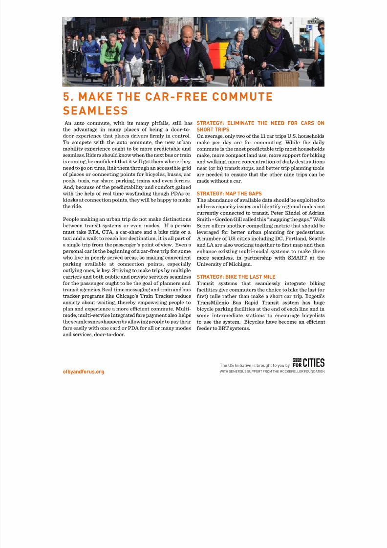
5. MAKE THE CAR-FREE COMMUTESEAMLESS An auto commute, with its many pitfalls, still hasthe advantage in many places of being a door-to-door experience that places drivers rmly in control.To compete with the auto commute, the new urban
mobility experience ought to be more predictable andseamless. Riders should know when the next bus or trainis coming, be condent that it will get them where they need to go on time, link them through an accessible gridof places or connecting points for bicycles, buses, carpools, taxis, car share, parking, trains and even ferries. And, because of the predictability and comfort gainedwith the help of real time waynding though PDAs orkiosks at connection points, they will be happy to makethe ride.
People making an urban trip do not make distinctionsbetween transit systems or even modes. If a personmust take RTA, CTA, a car-share and a bike ride or a taxi and a walk to reach her destination, it is all part of a single trip from the passenger’s point of view. Even a personal car is the beginning of a car-free trip for somewho live in poorly served areas, so making convenientparking available at connection points, especially outlying ones, is key. Striving to make trips by multiplecarriers and both public and private services seamlessfor the passenger ought to be the goal of planners andtransit agencies. Real time messaging and train and bus
tracker programs like Chicago’s Train Tracker reduceanxiety about waiting, thereby empowering people toplan and experience a more ecient commute. Multi-mode, multi-service integrated fare payment also helpsthe seamlessness happen by allowing people to pay theirfare easily with one card or PDA for all or many modesand services, door-to-door.
STRATEGY: ELIMINATE THE NEED FOR CARS ONSHORT TRIPSOn average, only two of the 11 car trips U.S. householdsmake per day are for commuting. While the daily
commute is the most predictable trip most householdsmake, more compact land use, more support for bikingand walking, more concentration of daily destinationsnear (or in) transit stops, and better trip planning toolsare needed to ensure that the other nine trips can bemade without a car.
STRATEGY: MAP THE GAPSThe abundance of available data should be exploited toaddress capacity issues and identify regional nodes notcurrently connected to transit. Peter Kindel of Adrian
Smith + Gordon Gill called this “mapping the gaps.” WalkScore oers another compelling metric that should beleveraged for better urban planning for pedestrians A number of US cities including DC, Portland, Seattleand LA are also working together to rst map and thenenhance existing multi-modal systems to make themmore seamless, in partnership with SMART at theUniversity of Michigan.
STRATEGY: BIKE THE LAST MILETransit systems that seamlessly integrate bikingfacilities give commuters the choice to bike the last (or
rst) mile rather than make a short car trip. Bogotá’sTransMilenio Bus Rapid Transit system has hugebicycle parking facilities at the end of each line and insome intermediate stations to encourage bicycliststo use the system. Bicycles have become an ecientfeeder to BRT systems.

8/2/2019 Connectivity Challenge Report
http://slidepdf.com/reader/full/connectivity-challenge-report 9/20ofbyandforus.org
The US Initiative is brought to you by
WITH GENEROUS SUPPORT FROM THE ROCKEFELLER FOUNDATION
6. INVEST IN CYCLING AND WALKING ANDEVERYTHING ABOUT YOUR CITY IMPROVES
A city’s vibrancy occurs at the human scale, where smallplaces and small signals allow people to take in detailsand connect with one another. When the public realm
bustles with pedestrians, it thrives as a meeting placeand market place.
More eyes on the street increases safety; more walking leads to better health outcomes; fewer cars meansfewer accidents; and more feet on the street is criticalto the success of local retailers. Investing in cycling and walking honors human interaction in a way thatinvesting in auto infrastructure cannot. It puts kids onequal footing as adults, and encourages people to interactwith their neighbors, thereby building community.
Cycling is also socio-economically neutral. In cities likeCopenhagen and Bogotá, biking has been widely adoptedas a transportation mode by even the wealthiest people.
STRATEGY: CYCLE TRACKIn 2007, New York City completed its rst cycle track(also referred to as a “buered bike lane”) – a bike laneadjacent to the curb protected from trac by a lane of parked cars. (Alternatively, a landscaped boulevard
may act as the buer rather than a row of parked cars.) Washington, DC, followed soon after with cycle trackof its own. The guiding principle of a cycle track is
to let parked cars or landscaping protect bicyclistsrather than the bicyclists protecting parked cars. Suchinfrastructure investments, along with simpler bikelanes, have led to a 28 percent increase in bicycling inNew York City in the last year alone.
STRATEGY: RED CARPET BIKE LANESPainting bike lanes bright colors helps alert motoristsof the presence of cyclists while increasing a senseof safety among cyclists. One participant referred tothese as “red carpet bike lanes” and noted that theyalso clearly signal to cyclists where dedicated lanes are
available to them.
STRATEGY: BIKE SHARINGFollowing the lead of successful car-sharing programsbike-sharing programs are one of the hottest cyclinginnovations popping up in cities throughout the U.S While bike-sharing is popular in many European citiesthe rst program in the states launched in Washingtonin 2008 with a modest 120 bikes located at 10 stations

8/2/2019 Connectivity Challenge Report
http://slidepdf.com/reader/full/connectivity-challenge-report 10/20ofbyandforus.org
The US Initiative is brought to you by
WITH GENEROUS SUPPORT FROM THE ROCKEFELLER FOUNDATION
The pilot was successful, and in 2010 Capital BikeShare put morethan 1000 bikes at 110 stations in the Washington metro area.Several other cities, including Chicago and Denver, have launchedbike share programs in partnership with B-Cycle, a national operatorthat aims to be for bike-sharing what Zipcar is to car-sharing. NewYork currently has a request for proposals to launch bike-sharing throughout the city.
What may be more exciting are much lower-cost solutions to bikesharing made possible through technology. One such solution is theSocial Bicycle System or SoBi, hoping to launch in New York. SoBi isa public bike share system that uses GPS, mobile communications,and a secure lock that can attach to almost any bicycle and lock to any regular bike rack.
STRATEGY: PLAN FOR BIKESMaking cycling a planning priority is a critical rst step to increasing cycling. Because of a very deliberate vision outlined in PlaNYC 2030,commuter cycling increased by more than 45 percent between 2006and 2009 in New York City. During that period, the city announced
and completed its goal of adding 200 additional miles of bike lanesin all ve boroughs. The visionary behind this transformation isNYC Transportation Commissioner Janette Sadik-Khan who, in herrst two weeks on the job, traveled to Copenhagen for inspirationand toured the city on bike with Jan Gehl. Copenhagen has themost robust biking culture in the world with 37 percent of residentscommuting by bike year-round, including in inclement weather.(By contrast, only 27 percent commute by car.) Even cab drivers inCopenhagen must plan for bikes; they are required by law to havetwo bike racks.
Chicago’s Bike 2015 Plan outlines city’s vision for making biking an integral part of the daily life of Chicagoans by increasing bicycleuse so that 5 percent of all trips less than ve miles are by bicycle. InPortland, the number one bicycling city in the U.S., nearly 7 percentof commuters opt for biking as their primary mode of transportation.Portland’s Bicycle Plan for 2030 calls for that number to increase to25 percent of total trips.

8/2/2019 Connectivity Challenge Report
http://slidepdf.com/reader/full/connectivity-challenge-report 11/20ofbyandforus.org
The US Initiative is brought to you by
WITH GENEROUS SUPPORT FROM THE ROCKEFELLER FOUNDATION
7. USE SUSTAINABILITYTO DRIVE CONNECTIVITY (“THE 20 PERCENT SOLUTION”)
Peter Kindle of Adrian Smith + Gordon Gill Architecture oered “The
20 Percent Solution,” --reducing road area by 20 percent, reclaiming 20 percent of a city’s ecological DNA, reducing carbon emissionsby 20 percent, increasing investments in pedestrian and bicyclesby 20 percent and reducing unnecessary signage and lighting by 20percent. Examples were cited in Seoul, Toronto and Indianapoliswhere asphalt has been reclaimed from cars to put people on moreequal footing. (In Toronto, the highway will be buried to create betterpublic access to the waterfront.) Green streets and eco-boulevardsare other alternatives for reclaimed roads.
Nearly all of the major transit systems in the country suer fromyears of deferred maintenance. As a result, agencies’ aspirationsare often limited to “State of Good Repair.” The problem is, Stateof Good Repair doesn’t excite riders or taxpayers. To excite peopleabout transit, transit agencies will need to move from “State of GoodRepair” to “State of the Art.” If transit agencies aren’t selling “Stateof the Art,” they are unlikely to get the support they need to achieve“State of Good Repair.” New, dedicated sources of public funding area hard sell, but are impossible to sell without ambitions that excitethe voting public.
Increasing ridership during o-peak times is the lowest hanging fruit in terms of generating new revenue from riders. Making thetransaction easier and more ecient also generates customerrevenue. Cities such as Chicago, Philadelphia and Washingtonare planning new fare systems that allow riders to pay fares with
bankcards, credit cards, smart phones and even employee IDs.
Aaron Renn, who writes under the name Urbanophile, was with usthroughout the Connectivity Challenge. Aaron has special statuson the subject of connectivity, with his award-winning proposal toincrease ridership on CTA. We are happy to provide his frameworkas an addendum to this report. It shows convincingly and in detailthe inextricable ties between land use and transportation.
8. MOVE FROM “STATE OFGOOD REPAIR” TO “STATEOF THE ART”

8/2/2019 Connectivity Challenge Report
http://slidepdf.com/reader/full/connectivity-challenge-report 12/20ofbyandforus.org
The US Initiative is brought to you by
WITH GENEROUS SUPPORT FROM THE ROCKEFELLER FOUNDATION
9. MAKE IT FASHIONABLE(AND EASY) TO RIDE THEBUS
Today nobody says they are going to take a bus
when they talk about TransMilenio.– Mayor Enrique Peñalosa
In most U.S. cities, bus ridership has historically been associatedwith people who could not aord a car. Buses have been consideredthe transportation choice of last resort. That’s one reason why somany cities choose more expensive rail options when they nally get serious about building a transit system of choice. They fear thecustomers they are targeting will never leave their cars for buses.Fortunately, cities around the world are adopting innovative busservice that transcends its “last choice” image.
STRATEGY: BUS RAPID TRANSITBus Rapid Transit (BRT) is a system that uses buses to approachthe service quality and speeds of rail transit while maintaining theexibility and aordability of not laying tracks. It is faster than anordinary bus system because it uses dedicated lanes, and an o-board fare system and is capable of loading multiple passengers atone time at vehicle level. BRT is exploding in Latin American and Asian countries that require high-class, self-sustainable and moreecient ways to move large numbers of people. BRT systems aremost successful when they have been integrated into high-quality sidewalks, bicycle infrastructure, parks and plazas.
Bogotá’s TransMilenio is often cited as a world-class example of BRT. TransMilenio riders pay at a station entrance via a contact-lesssmart card, pass through a turnstile, and await the arrival of the businside the station. The bus and station doors open simultaneously,and passengers board by simply walking across the threshold. Likea subway system, the elevated station platform and the bus oor areat the same height. The stations act as hubs and have fewer stopsthan regular bus lines. Combined with the size of the BRT buses (thelargest buses in the TransMilenio system accommodate 270 ridersat a time) the system is designed to move a lot of people eciently through a city cost eectively. Today, the cost of a single trip amounts
to about 85 cents USD. BRT systems can be eectively integratedinto feeder bus services to reach destinations not available on themain BRT routes. In Bogotá, there is no additional fare to transfer tothese “feeder” buses. The operational cost of TransMilenio, unlikerail systems, is covered with the fare. he replication of TransMilenioin other cities has also brought a new range of BRT systems from FullBRT to Light BRT.
8/2/2019 Connectivity Challenge Report
http://slidepdf.com/reader/full/connectivity-challenge-report 13/20ofbyandforus.org
The US Initiative is brought to you by
WITH GENEROUS SUPPORT FROM THE ROCKEFELLER FOUNDATION
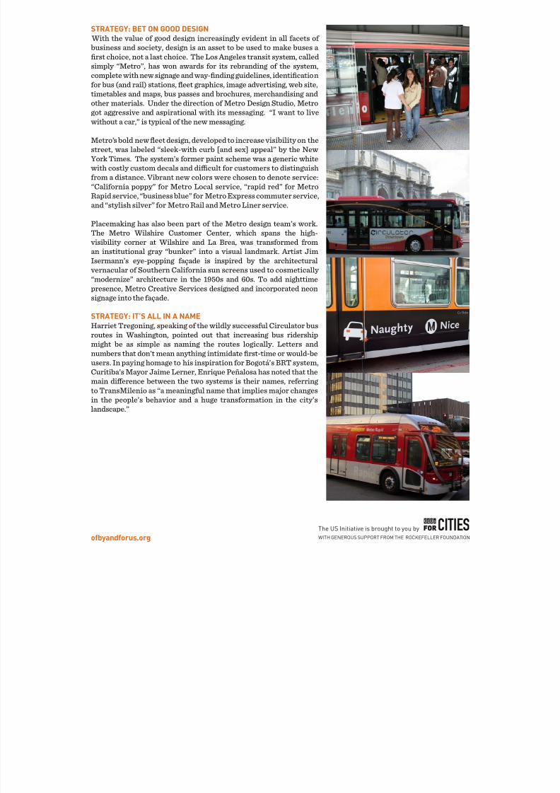
STRATEGY: BET ON GOOD DESIGN With the value of good design increasingly evident in all facets of business and society, design is an asset to be used to make buses a rst choice, not a last choice. The Los Angeles transit system, calledsimply “Metro”, has won awards for its rebranding of the system,complete with new signage and way-nding guidelines, identicationfor bus (and rail) stations, eet graphics, image advertising, web site,timetables and maps, bus passes and brochures, merchandising and
other materials. Under the direction of Metro Design Studio, Metrogot aggressive and aspirational with its messaging. “I want to livewithout a car,” is typical of the new messaging.
Metro’s bold new eet design, developed to increase visibility on thestreet, was labeled “sleek-with curb [and sex] appeal” by the NewYork Times. The system’s former paint scheme was a generic whitewith costly custom decals and dicult for customers to distinguishfrom a distance. Vibrant new colors were chosen to denote service:“California poppy” for Metro Local service, “rapid red” for MetroRapid service, “business blue” for Metro Express commuter service,and “stylish silver” for Metro Rail and Metro Liner service.
Placemaking has also been part of the Metro design team’s work.The Metro Wilshire Customer Center, which spans the high-visibility corner at Wilshire and La Brea, was transformed froman institutional gray “bunker” into a visual landmark. Artist JimIsermann’s eye-popping façade is inspired by the architecturalvernacular of Southern California sun screens used to cosmetically “modernize” architecture in the 1950s and 60s. To add nighttimepresence, Metro Creative Services designed and incorporated neonsignage into the façade.
STRATEGY: IT’S ALL IN A NAMEHarriet Tregoning, speaking of the wildly successful Circulator busroutes in Washington, pointed out that increasing bus ridershipmight be as simple as naming the routes logically. Letters andnumbers that don’t mean anything intimidate rst-time or would-beusers. In paying homage to his inspiration for Bogotá’s BRT system,Curitiba’s Mayor Jaime Lerner, Enrique Peñalosa has noted that themain dierence between the two systems is their names, referring to TransMilenio as “a meaningful name that implies major changesin the people’s behavior and a huge transformation in the city’slandscape.”

8/2/2019 Connectivity Challenge Report
http://slidepdf.com/reader/full/connectivity-challenge-report 14/20ofbyandforus.org
The US Initiative is brought to you by
WITH GENEROUS SUPPORT FROM THE ROCKEFELLER FOUNDATION
10. RECLAIM THESTREETS, BUT SLOWLY,SO NO ONE NOTICES (ALSO
KNOWN AS “THE 3 PERCENTSOLUTION”)
In Copenhagen, transportation ocials reduced available parking
by 1, 2 or 3 percent per year over a 25-year period so that no oneeven noticed it was happening. The eect was a more vibrant andpedestrian-friendly street life that brought new energy and joy toresidents; it was enough to oset the frustration of having fewerparking spaces.
STRATEGY: NEW PARKING REGULATIONSChanging parking requirements to make it more expensive and/or dicult to park may be the most eective way to reclaim streetsfor non-auto uses. In cities with strong urban real estate markets,o-street parking spaces can cost up to $45,000 and are coupledwith mortgages in real estate transactions. But in Washington,ocials changed regulations to de-couple parking from real estatetransactions, thereby giving car-free homebuyers a choice to nothave parking (a not insignicant cost-of-living expense). In somecases, those spaces are sold to neighboring commercial uses, whichsimultaneously increases parking capacity for businesses whiletaking cars o the street. In Brighton, England regulatory changesallowed one developer to apply cost savings from not building parking to investments in net zero energy technologies.
STRATEGY: PERMANENT STREETCLOSURESReclaiming the ground plane, reducingtrac and congestion pricing cancontribute to the health and quality of urbanspaces, and experiences in London andNew York show that such improvementsin those cities has resulted in net increases
in retail sales. In fact, data show that sinceclosing Times Square to trac six months
ago, retail sales have increased 71 percent.
STRATEGY: ONE LESS CARMany cities across the U.S. have launchedcar-sharing programs like Zipcar, iGoand GoLoco to encourage households toreduce the number of cars they own. Inaddition, some neighborhoods, even someindividuals, have started their own car-sharing programs in the form of private
peer-to-peer car-sharing. Car-sharingmakes better use of the time cars wouldotherwise sit parked (reported to be 90percent of the time). Whipcars in Londonand RelayRides in Boston are two suchprograms. State insurance laws can be abarrier to individual car-sharing, but it islikely that such laws will eventually yieldto demand.
STRATEGY: CONGESTION PRICINGJan Gehl oered his brilliant and witty“discotheque doorman” principle: whenthe city is full (of cars), don’t let more inCongestion pricing levies a fee on carstraveling into and out of the city during peaktimes and has been adopted in London andattempted in New York. However, it is a verydicult strategy to implement politicallyOther congestion reduction strategiesproposed include not allowing cars to runduring peak hours on a particular day (ortwo) of the week and requiring o-sets
such as green space (“congestion parks”)In the case of the latter, a park fund or set-aside makes congestion pricing politicallymore palatable.

8/2/2019 Connectivity Challenge Report
http://slidepdf.com/reader/full/connectivity-challenge-report 15/20ofbyandforus.org
The US Initiative is brought to you by
WITH GENEROUS SUPPORT FROM THE ROCKEFELLER FOUNDATION
11. CELEBRATE A CULTURE OF WALKINGAND BIKING
Good city life is like a good party
People stay longer than planned
- Jan Geh
Cities that make it possible for their citizens to livewithout a car, also make it fun to live without a car.Jan Gehl boiled this down to the must fundamental
of strategies: be sweet to people. When we aresweet to people, we can achieve a lively, attractive,safe, sustainable and healthy city. But changing theculture, the mindset and the political will to one thatembraces walking and biking as more important thanaccommodating the car is no small feat in U.S. cities.It requires bringing labor, business and governmentstogether to insure that projects deliver maximumreturn. It also requires bold leadership.
STRATEGY: PILOT PROJECTSIn New York, Janette Sadik-Khan was able to navigatepotential landmines while accelerating change withpilot projects. The closing of Times Square to tracbegan as a pilot (one she describes as “working a lot of mischief with a bucket of paint”) and is now a
permanent, lively pedestrian plaza reaping realeconomic benets for the city.

8/2/2019 Connectivity Challenge Report
http://slidepdf.com/reader/full/connectivity-challenge-report 16/20ofbyandforus.org
The US Initiative is brought to you by
WITH GENEROUS SUPPORT FROM THE ROCKEFELLER FOUNDATION
12. INVEST INAN EMERGINGNEW MOBILITYECONOMY“Pubic Transit” has, until recently, beenunderstood as a public cost or drain onever- diminishing public resources.Highways, on the other hand, havemore often been referred to as an“investment.” As the world urbanizes,and as new and innovative technologies,services and modes emerge to supply connected and seamless mobility andaccessibility to the 2/3 of the Americans
who live in growing urban regions, theinvestment balance tips towards themore sophisticated, multi-faceted andseamless systems and infrastructures.
Not only do greater and more connectedtransportation choices increaseeciency, productivity and quality of life in cities, and therefore theireconomic vitality and competitiveness,
these innovations also form thefoundation of an emerging globalnew mobility industry. This oers a signicant upside for the U.S. economy to cultivate new and related jobs,both within major business areas likemanufacturing, telecommunicationsand logistics, as well as the many up andcoming entrepreneurs ready to apply their innovations to transforming transportation and economies in
cities. The University of MichiganSMART program has been engaging in“public private innovation” with big business and small entrepreneurs towork collaboratively to evolve the nextgeneration of urban (and sustainable)transportation.

8/2/2019 Connectivity Challenge Report
http://slidepdf.com/reader/full/connectivity-challenge-report 17/20ofbyandforus.org
The US Initiative is brought to you by
WITH GENEROUS SUPPORT FROM THE ROCKEFELLER FOUNDATION
ADDENDUM:Transit Governance & Op erations Framework

8/2/2019 Connectivity Challenge Report
http://slidepdf.com/reader/full/connectivity-challenge-report 18/20
Ridership
Capacity Financing
Optimize Existing
New Build
Grow CBD Employment
Land Use Policy
Generate Transit
Addressable Trips
Transit Governance and Operating Model
ource: Aaron Renn, Urbanophile, 2011
8/2/2019 Connectivity Challenge Report
http://slidepdf.com/reader/full/connectivity-challenge-report 19/20ofbyandforus.org
The US Initiative is brought to you by
WITH GENEROUS SUPPORT FROM THE ROCKEFELLER FOUNDATION
CHALLENGE PARTICIPANTS
Erin Aleman, Chicago Metropolitan Agency for Planning
Rita Athas, World Business Chicago
Gerald Bennett, Chicago Metropolitan Agency for
Planning
Randy Blankenhorn, Chicago Metropolitan Agency for
Planning
Ron Burke, Active Transportation AllianceCharlie Cannon, Rhode Island School of Design
Carol Coletta, CEOs for Cities
Joe Costello, Chicago Regional Transportation Authority
Benjamin De la Pena, The Rockefeller Foundation
Oscar Edmundo Diaz, Institute for Transportation and
Development Policy
Doug Farr, Farr Associates Architecture and Urban
Design
Sheena Freve, Chicago Metropolis 2020
Jan Gehl, Gehl Architects
Melody Geraci, Active Transportation Alliance
Ben Gomberg, City of Chicago, Department of Transportation
Barbara Gordon, Chicago Architecture Foundation
Kierston Grove, City of Chicago, Department of
Transportation
Luann Hamilton, City of Chicago, Department of
Transportation
Adolfo Hernandez, Active Transportation Alliance
Nate Hernandez, Chicago Transit Authority
Peter Kindel, Adrian Smith + Gordon Gill Architecture
Lindsay Kinkade, Rhode Island School of Design
Julia Klaiber, CEOs for Cities
Erin Lavin Cabonargi, City of Chicago, Public Building
Commission
Jill Leary, CMAP
Terry Mazany, Chicago Community Trust
Kate McAdams, Oce of the Mayor, City of Chicago
Tom McKone, Civic Consulting Alliance
Theresa Mintle, Chicago Transit Authority
John Norquist, Congress for New Urbanism
Diane Palmer, Chicago Regional Transportation Authority
Terry Peterson, Chicago Transit Authority
Leanne Redden, Chicago Regional Transportation
Authority
Eric Reese, Chicago Transit Authority
Aaron Renn, Urbanophile
Steve Schlickman, Executive Director, Urban
Transportation Center, University of Illinois Chicago
Peter Skosey, Metropolitan Planning Council
Ethan Spotts, Active Transportation AllianceScott Stowell, OPEN
Harriet Tregoning, Government of the District of
Columbia
Alissa Walker, GOOD
Bobby Ware, City of Chicago, Department of
Transportation
Ruth Wuorenma, Neighborhood Capital Institute
Susan Zielinski, University of Michigan Transportation
Research Institute
SPECIAL THANKS
The Connectivity Challenge was made possible with generous support from the ChicagoCommunity Trust and The Rockefeller Foundation. The Chicago Architecture Foundationfurther provided their beautiful space and helping hands.
8/2/2019 Connectivity Challenge Report
http://slidepdf.com/reader/full/connectivity-challenge-report 20/20