Embed Size (px)
Citation preview

Confluence NWS Hydrology Program News
Issue #5 September 2013
Headwaters CAPT Barry Choy
In this issue…
Page 1
Welcome to this issue of Confluence! I’ve
had the privilege of being the Acting Director
of the Office of Hydrologic Development for
the past 8 months. They have been exciting
times. I’d like to take this opportunity to
provide a message to the folks of the NWS
Hydrology Program – the national and
regional headquarters groups, the Hydrology
Laboratory, the River Forecast Centers, and the Weather Forecast Offices
who support the NWS hydrology mission.
We’re about to take ownership of the first ever National Water Center, a
hallmark event for the hydrology program and the country as we move
forward, in collaboration with our federal partners under the auspices of
Integrated Water Resources Science and Services (IWRSS), to address our
water resource needs and plan for a water secure future. This will be a
world-class facility for collaborative development, infusing new ideas,
research, and methods of operating more efficiently and effectively to
provide our customers the very best forecast guidance, information, and
decision support services. This shift to focus on water resources represents
a national interest in clean, plentiful water supplies and realizing that,
without action based on sound science, our water supplies are in jeopardy.
Our public demands a better scientific understanding of water quantity and
quality, and is betting on the NWS’ and your ability to improve
predictability of floods, low water conditions, water quality, and water for
• Headwaters (1) • Awards (2) • National Center
Spotlight – WPC FFaIR experiment (3)
• IT Corner (4) • Partner Spotlight
– USACE (5) • Retirements (7) • Field Spotlight –
OHRFC (8) • Wavefronts (9) • Stakeholder
Engagement (10) • CHPS Bits (12) • National Water
Center Update (13)

NWS Hydrology Program News Issue #5, September 2013
Page 2
ecological health, among other things. It’s going to be a lengthy and
complex process to fully achieve the vision for a NWC and a modernized
hydrologic program and as the future leaders in hydrology you have the opportunity to shape
that vision in the coming years and participate in addressing one of our nation’s most pressing needs.
We have all had front row seats in viewing the struggles during these challenging budgetary times and
while this slows progress it hasn’t stopped us or reduced our resolve. We continue to move forward with
the very initial staffing recommendations for the NWC and have the support of the leadership within the
NWS to “make things happen” despite the current budget uncertainties. The clouds will clear and the sun
will shine again soon for the NWS and those of you who weather these challenging and uncertain times
will have significant opportunity to emerge as the new leaders for the organization. You may not realize it
yet, but you’re living the very beginning of a transformation for hydrologic services within the NWS and I
have no doubt that in a few years from right now you’ll look back on this period and realize you had a hand
in something great. Save this edition of Confluence and please find me in the coming years and tell me
about your journey. Like any forecaster tracks skill, please let me know how this one verifies.
I’ve enjoyed serving as the Office of Hydrologic Development Director for the last several months,
learned an awful lot, and know you’ll have an even stronger leadership team to follow, a team who will
move the ball forward. Thank you. - Barry
Headwaters continued…
Max A. Kohler
Award 2012 Katelyn Costanza,
Senior Hydrologist at
NWS Lower
Mississippi River
Forecast Center
(LMRFC), has done
extensive work with
stakeholders in the
Gregg B Rishel Award
2013
LMRFC area and has played an integral role in
the advancement of the RFC’s hydrologic
program. This award recognizes an individual
for hydrologic science and/or service
contributions which support the fulfillment of
the hydrologic services mission of the National
Weather Service.
Harold Opitz,
Hydrologist-In-
Charge at the
Northwest River
Forecast Center, has
made significant
contributions to
hydrologic research, facilitating cooperative
efforts with other agencies, improving/investing
in hydrologic projects, and advancing hydrologic
services. This award is presented annually to
honor individuals for sustained superior
performance and distinguished accomplishments
in support of the National Weather Service
Hydrology Program.

Flash flooding is a hazard that lies at the interface of meteorology and hydrology. The Weather Prediction
Center (WPC) produces a suite of flash flood forecast guidance by considering both quantitative
precipitation forecasts (QPFs) and the hydrologic response. In particular, the new WPC Met Watch Desk
focuses on flash flood threats in the 1 – 6 hour timeframe. While the WPC is historically a QPF-focused
center, it is recognized that a keen understanding of the hydrologic response to QPF is critical to providing
skillful flash flood forecast guidance.
In collaboration with the National Severe Storms Laboratory (NSSL) and Earth System Research
Laboratory (ESRL), the Hydrometeorological Testbed at the Weather Prediction Center (HMT-WPC) hosted
the first annual Flash Flood and Intense Rainfall Experiment (FFaIR) from 8-26 July, 2013. The experiment
brought together 26 meteorologists, hydrologists, researchers, and model developers, including eight remote
participants from WFOs and RFCs,
to explore the challenges associated
with short-term QPF and flash flood
forecasting during the warm
season. Each day, participants
collaborated to produce an array of
flash flood forecasts for the high-
impact area of the day.
One goal of the experiment was to
evaluate the utility of high resolution
convection-allowing models and
ensembles for short-term QPF and
flash flood forecasts. Participants leveraged these ensemble datasets, including tools such as the ensemble
probability of QPF greater than RFC Flash Flood Guidance (probability of QPF>FFG), as guidance to make
probabilistic flash flood forecasts. Although both the meteorological and hydrologic guidance have
limitations, it was found that tools that combine both sources information have potential to provide skillful
flash flood forecasts.
Another goal of the experiment, and a difficult one to achieve, was to verify the flash flood forecasts. A
recurring challenge throughout the experiment was determining when and where flash flooding had occurred
since there is no single observational dataset that accurately depicts all flash flood events. Each morning
during the experiment, participants assimilated an array of data to determine areas that were affected by
flash flooding during the preceding day. These data included local storm reports (LSRs), WFO-issued flash
flood warnings, return periods from a distributed hydrologic model (NSSL-FLASH), areas where radar
NWS Hydrology Program News Issue #5, September 2013
Page 3
The 2013 Flash Flood and
Intense Rainfall Experiment (FFaIR)
By Wallace Hogsett, Faye Barthold and Tom Workoff

NWS Hydrology Program News Issue #5, September 2013
Page 4
QPE exceeded FFG, among other datasets.
The FFaIR Experiment provided a unique opportunity to bring the meteorological and hydrologic
communities together to explore the challenges of both short-term QPF and flash flood forecasting. The
experiment provided valuable input to guide the development of new forecast tools to support WPC’s
flash flood guidance suite, including the new Met Watch Desk, and raised awareness about the
limitations of the currently available forecast guidance. This Fall, a complete summary of the inaugural
FFaIR experiment will be published on the HMT-WPC website (http://www.wpc.ncep.noaa.gov/hmt/).
The 2013 Flash Flood and
Intense Rainfall Experiment (FFaIR) continued…
Information Technology Corner James Rawls
In our last issue I discussed ITSM in a high level, management driven perspective. One certainty of
ITSM is enabling people, a set of processes, and managing them, will not happen without senior
management influence and the governance they provide. So let’s start with the people, processes, and
management of these resources. ITSM is business driven, and will vary based on supporting the needs
of the business goals and the customer. So let’s look at the pieces.
People are the human resources required to enable the business goals. That staff is a critical piece
of the puzzle. Staffing will encompass technical, management, and even administrative skills. While
we primarily view ITSM as purely technical in delivery, the program/project managers and budget
staff play important roles to ensure the other two pieces are in place and available to the technical staff.
The other two involve the processes of direct technology, and the management and oversight of the
workflow. The technology piece involves hardware, software and network availability which are used
by the technical staff. So in reality the people and technology pieces are the direct delivers of those
processes, and the management piece provides monitoring, and the goal of process improvement.
The success factor in ITSM depends on all three of the above, and how well each is done.
Measuring success isn’t just a senior management responsibility, but directly depends of how the
customer views it all. An old saying “the customer is always right” is the driver on how ITSM is
delivered, managed, and improved. So we hire the appropriate staff, provide them with the necessary
technology, and then allow management to monitor and improve. Next issue let’s break down the
people, processes and the supporting technology, and management.
IT Service Management – The Core Services?

NWS Hydrology Program News Issue #5, September 2013
Page 5
Bob serves as the Director of
USACE’s Institute for Water
Resources and the International
Center for Integrated Water
Resources Management,
under the auspicious of UNESCO.
USACE Spotlight
Institute for Water Resources Bob Pietrowsky, USACE IWR
From its beginnings, the U.S. Army Corps of Engineers
(USACE or Corps) Institute for Water Resources (IWR) has
occupied a unique position within the Corps Civil Works
program. As a separate field operating activity (FOA) reporting
to the Corps Headquarters, the Institute is not directly part of
USACE’s project execution organizational hierarchy or
laboratory structure. Yet its challenging mission as a water
resources “think tank” has been and remains integral to shaping
the strategic direction of the Civil Works program.
IWR owes its creation to the sweeping changes in water
development policies in the decades leading up to passage of the
National Environmental Policy Act in early 1970. As the public
demand for water projects increased in post-WWII America, so
did the “thirst” for USACE Civil Works projects likewise expand
to meet this need. And, as the Federal outlays on water projects
increased, controversies over large public works and the
priorities for government spending continued to elevate the
visibility of issues surrounding the Federal role in providing
water resources services.
Although the conditions that stimulated the creation of IWR have changed over the last 45 years, the
water resources issues of today have evolved to reflect new challenges stimulated by factors such as the
rapid pace of technology and scientific advancements, evolving public values, an aging water
infrastructure and seriously constrained budgets. In response, Corps decision-makers have increasingly
looked to the Institute for advice on a host of perplexing policy and technical issues. As such, the need
for a diverse set of professional, independent water experts to pursue innovative approaches to solve
problems in a collegial, nonpartisan setting remains as compelling today as any time in the Institute’s
history.
Today, IWR serves as the USACE’s knowledge center for integrated water resources management
(IWRM), and is recognized as a national center of expertise in water resources planning methods, risk
analysis, hydrologic engineering, conflict resolution and public participation, international water
resources, global climate change science, and the collection, management and the dissemination of
Civil Works program information and navigation related infrastructure performance information,
including the Nation’s waterborne commerce data.

NWS Hydrology Program News Issue #5, September 2013
Page 6
IWR has offices at five locations, each of which is a USACE
designated center of expertise. IWR’s main office located in Alexandria, VA
includes the Institute’s executive office and the critical mass of its planning methodologies,
socio-economic and strategic planning expertise, while also housing three of its centers – the
Navigation and Civil Works Decision Support Center (NDC), the International Center for Integrated
Water Resources Management (ICIWaRM), and the Conflict Resolution and Citizen Participation. The
Institute’s Hydrologic Engineering Center (HEC), specializing in the development of the HEC suite of
hydrologic, hydraulic and reservoir system and related models, is located in Davis, CA, while the
Waterborne Commerce Statistics Center, is located in New Orleans, LA. The Risk Management
Center (RMC), specializing in the engineering aspects of dam and levee safety, has offices in Golden,
CO and Pittsburgh, PA.
In addition to leading USACE’s technical participation in national and international water forums,
the Institute’s water resources mission involves the production of white papers and policy-oriented
national reports; a wide range of training and education events and instruments; the production of
technical guidance, handbooks and manuals for USACE practitioners; the promulgation of new
planning and decision-support methodologies; the development of improved hydrologic engineering
methods and software tools; the advancement of risk analysis as applied to public works infrastructure;
and the management of national waterborne commerce statistics and other Civil Works information
systems. National interface with other agencies, NGO’s, and academia, along with the infusion of new
knowledge and technology across USACE also remain key focal areas of the Institute. Through
ICIWaRM, which is affiliated with UNESCO’s International National Hydrological Program (IHP),
IWR supports U.S. capacity development efforts overseas as a means to improve water security around
the globe.
One illustration of IWR’s technical role in supporting USACE is its involvement in the Corps
collaboration with the National Weather Service (NWS) and USGS on the tri-agency partnership on
Integrated Water Resources Science and Systems (IWRSS). IWRSS represents a truly contemporary
interagency collaboration aimed at synchronizing and leveraging each agency’s mission contributions
in science, water resources services and the use of analytical tools in order to support jointly developed
and integrated water resources management advancements that are useful to other Federal agencies,
States and others responsible for water management.
Two manifestations of this partnership are ongoing efforts on (1) developing a common operating
platform for providing national flood inundation mapping services, and (2) ensuring that each agency’s
information can be seamlessly shared through improved system interoperability and data
synchronization. Interagency work groups on each of these efforts were established last year, and these
groups have just produced “Requirements” documents which articulate a path forward for better
integrating our respective agency’s flood mapping and related water services in the future. I’m
delighted that the Institute, through its Hydrologic Engineering Center, led by HEC Director Chris
USACE Spotlight continued…
NWS Hydrology Program News Issue #5, September 2013
Page 7
Dunn, is playing a key technical role in the charter efforts.
In addition, a third charter is currently being formulated on the long term collaborative development
of a new national hydrological model based on an earth-systems context that integrates the next
generation of hydrologic and atmospheric modeling capabilities within the U.S.
As IWR Director it is not only a privilege to work with and lead so many gifted water resources
colleagues within the Institute and across USACE, but it’s also been very fulfilling to team with our
IWRSS partners working through: Don Cline and Tom Graziano at NWS and Jerad Bales and Robert
Mason at USGS, who along with James Dalton, Jerry Webb and Chandra Pathak from the USACE
Headquarters, have proved to be a very effective senior scientist/engineering team.
IWRSS is providing us all with a much greater appreciation of the advantages of an interagency
engagement paradigm based on a true “whole-of-government” approach. The team is already seeing a
glimpse of IWRSS’s promise as we observe first-hand the progress being made towards improved data
sharing and model integration – enhancements that will serve to conserve resources, deliver more
accurate, consistent, and timely forecasts, and, from USACE’s perspective, ultimately provide us with
more informed water management decision-making capabilities during critical real-time operations of
the network of Corps reservoirs and other water control structures across the U.S It is this desired
outcome – providing enhanced life safety information, services and operations for the American people –
that is motivating both the IWRSS team and the three participating agencies to strongly commit to this
collaboration.
For further information about the Institute for Water resources, please check out our website at
http://www.iwr.usace.army.mil/, while additional information about IWRSS can be found at:
http://www.nws.noaa.gov/oh/docs/IWRSS_1p_summary.pdf.
USACE Spotlight continued…
On May 2, Greg Lamberty retired after 21 years of service with NWS. Greg joined
NWS in 1992 as a Met Intern working at Marseilles, IL; Evansville, IN; and Paducah,
KY before becoming a Service Hydrologist in 1997 at the new WFO in Northern
Indiana (IWX) where he was involved in two significant hydrologic events. The
January 2005 ice jam/flood event earned him the group DOC Silver Medal. Greg
moved on in 2007 becoming the Senior Service Hydrologist in Columbia, SC where he
quickly transitioned from floods to extreme drought services.
Retirement Announcement

NWS Hydrology Program News Issue #5, September 2013
Page 8
WFO Wilmington (ILN), the Ohio River Forecast Center (OHRFC), and United States Geological
Service Ohio Water Science Center (USGS) teamed up to provide a unique, innovative forecasting
solution for the Ohio Department of Transportation (ODOT). A low spot on Interstate 70 near Newark,
Ohio has an elevated risk for flooding from the South Fork Licking River. With adequate warning, ODOT
could deploy crews to monitor the interstate and shut down traffic if conditions became too hazardous.
ODOT sought help from USGS to identify potential solutions to the flooding, and USGS brought the
problem to ILN and OHRFC to utilize hydrologic forecasting services.
The location is too complicated for a simple hydrologic model. At I-70, South Fork Licking River
includes flow from a large headwater area as well as flow from Buckeye Lake. Further complicating the
hydraulics, Buckeye Lake has two different outlets with different controls on each. Depending on lake
levels, these outlets behave differently - one is a simple weir structure that only becomes active at higher
lake levels the other is a control structure that is meant to be operated according to a lake management
plan.
Forecasting Services for
the Ohio Department of Transportation OHRFC
OHRFC determined a suitable strategy for modeling this location was a hydraulic model, and chose
the U.S. Army Corps of Engineers (USACE) HEC-RAS model. USGS established a field program to
collect cross-section data and flow information around the site and constructed a HEC-RAS model of
the area. OHRFC combined this with detailed overbank elevation data to improve and expand the HEC-
RAS model, adjusted the calibration and configured it to work in the Community Hydrologic Prediction
System (CHPS). Next, OHRFC and ILN established an innovative modeling and communication
process to notify ODOT of potential flooding at this location. OHRFC runs the model two times per day
or more frequently as necessary and notifies ODOT and ILN when a forecast shows flooding
approaching the roadway elevation. A graphical hydrograph is sent when action stage is approached.
This is a great example of several public agencies responding to a demand for hydrologic services to
protect lives and property. With this development ODOT can rely on OHRFC to notify them about a
potentially dangerous condition.
NWS Hydrology Program News Issue #5, September 2013
Page 9
Wavefronts: New
Developments in Hydrology Tim Schneider
In the last issue of Confluence (Issue #4, March, 2013), we were introduced to a model called ParFlow,
which explicitly coupled surface and subsurface processes. In this article we would like to introduce you
to something of a quite different nature: a framework designed to couple together multi-scale process
models (or data) of the atmosphere and terrestrial hydrology. WRF-Hydro is a hydrologic extension of
the successful, community-based Weather Research and Forecasting (WRF) model, which is used in
thousands of research and operational centers around the globe.
The development of WRF-Hydro is led by Dr. David Gochis, along with a team of NCAR and
University scientists and engineers. However, the effort has adopted a ‘community-based’ development
processes with an open and participatory working group environment. This means that the code, the
documentation, and the applied knowledge user base, is much greater and more robust.
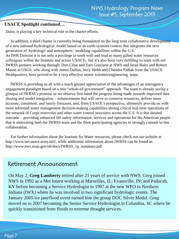
So what is WRF-Hydro? It is an extensible, multi-scale coupling architecture to link weather and
climate models with hydrological component models. Flexibility is at its core. Technically, a collection of
“flux and state coupling software” which manages the flow of time and the grids is at WRF-Hydro’s core.
But the hydrometeorological inputs could be gridded observational data, or fully (two-way) or singly
coupled models ranging from very high resolution nowcast systems to long-range regional climate
models. And on the terrestrial hydrology side, the system has “hooks” for varied models of the column
land surface; subsurface flow routing; channel and overland flow routing; water management; and land
surface and hydrological data assimilation.

NWS Hydrology Program News Issue #5, September 2013
Page 10
As our water resource management challenges grow in complexity and
compound, it seems certain we will need to ask more of one of our most fundamental tools -
models. So it is natural to expect our tools to grow in complexity (physics and chemistry) and scale (time
and space). So in the future we expect that we will be running our models on some “big iron.” Which
takes us to another interesting and important aspect of the WRF-Hydro architecture: it has been designed
and tested to run in a variety of high performance computing environments.
The first official version of the WRF-Hydro system, Version 1, was released in April 2013. It includes
an initial suite of basic hydrological model components, which can be run in coupled or uncoupled mode
right out of the box. But this is a dynamic community effort, so look for more features and capabilities in
future releases. To date, the WRF-Hydro system has already been applied for a wide range of research and
operational prediction problems both in the U.S. and abroad. Past projects include flash flood prediction,
regional hydroclimate impacts assessment, seasonal forecasting of water resources and land-atmosphere
coupling studies.
You can learn more about this work and download the documentation and the code at:
http://www.ral.ucar.edu/projects/wrf_hydro/
Wavefronts: New
Developments in Hydrology continued…
IWRSS Stakeholder Engagement Forums Mary Mullusky
Integrated Water Resources Science and Services (IWRSS), is a new business model for interagency
collaboration consisting of a consortium of federal agencies with complementary missions in water
science, observation, management and prediction. IWRSS’ overarching objective is to enable and
demonstrate a broad, integrative national water resources information system to serve as a reliable and
authoritative means for adaptive water-related planning, preparedness and response activities. The leaders
of NOAA, the U.S. Army Corps of Engineers (USACE), and the U.S. Geological Survey (USGS)
formalized the partnership in May 2011 by signing a Memorandum of Understanding for the
Collaborative Science, Services and Tools to Support Integrated and Adaptive Water Resources
Management. Since then the agencies began working to align programs and set up management
mechanisms to support IWRSS implementation.
IWRSS partner agencies understand that enhanced partnerships are necessary to efficiently deliver
expanded and more integrated water resources services. As such, to enhance stakeholder interactions,
socialize objectives, and inform the design and development of IWRSS, NOAA in coordination with the
USGS and the USACE, conducted four 1-day in-basin stakeholder engagement forums to validate existing
and identify new gaps in water resource services. The forums were conducted in coordination with four

NWS Hydrology Program News Issue #5, September 2013
Page 11
major stakeholders:
1) the Delaware River Basin
Commission (December 13,
2012), 2) the Interstate
Commission on the Potomac
River Basin (February 6,
2013), 3) the Susquehanna
River Basin Commission
(February 28, 2013), and the
4) Hudson River Foundation
(June 27, 2012). At each in-
basin forum, a group of
approximately 30
stakeholders from national,
regional, state and local
organizations representing
diverse interests, discussed
IWRSS Stakeholder
Engagement Forums continued…
water resource issues affecting the respective river basin. Attendees learned about hydrologic services
envisioned to be provided by IWRSS, identified key gaps IWRSS might fill to inform water resources
decision making, articulated socioeconomic benefits of addressing these gaps, and discussed possible
demonstration projects for IWRSS to meet those gaps.
In advance of the 1-day forums, participants were polled to determine the highest priority water
resources issues for the basin. Common priorities across all four basins included water availability and
use, water extremes (flooding and drought), water quality and climate change impacts. The groups were
charged to identify key decisions, questions, and gaps that IWRSS could address. The most commonly
identified gaps involved: (1) models, analysis and reliable forecasts; followed by (2) data and monitoring;
(3) communication and decision support needs; and (4) sediment transport and sedimentation information
needs. Stakeholders also identified and discussed possible demonstration projects to build capacity for
tri-agency integrated water resources management and explored the socio-economic benefits of such
projects. The results of the stakeholder engagement forums and a follow on survey will be used to inform
and guide the design and development of IWRSS and develop a business case to garner the resources
necessary to deliver new/improved IWRSS services.

NWS Hydrology Program News Issue #5, September 2013
Page 12
CHPS Bits : New Release Jon Roe
The summer semi-annual release of CHPS, CHPS-4.0.1, is expected to be available to the
RFCs in late October. CHPS-4.0.1 will include:
1. Delft-FEWS 2013.01
2. OHD-CORE-CHPS
-Second release of the Graphics Generator, including updates to software and documentation to address
issues found at the RFCs with the first release
- Initial baseline release of the CHPS Calibration Service, a joint effort between Deltares and OHD that
combines existing Delft-FEWS features and custom OHD developed functionality. For example, a part
of the Calibration Service includes a CHPS version of the statistical package previously delivered with
NWSRFS (i.e., STAT-QME). Where possible, the various STAT-QME calculations and reports were
implemented using existing Delft-FEWS features; where not possible, features were implemented using
custom OHD software
- Documentation for OHD delivered CHPS features is now being consolidated on the web at
http://www.nws.noaa.gov/oh/hrl/general/indexdoc.htm which is still under construction
3. HEC Models in CHPS
- Performance improvements were made to the CHPS HEC-RAS adapter, prompted by NCRFC's request
to use HEC-RAS during multi-year historical runs
- No changes for HEC-ResSim
CHPS Bits : New Training Jon Roe
In August the NWSTC announced that the CHPS
“RFC User” module is now available. It provides
instructions on creating daily and supplemental
forecast products and takes about 3.5 hours to
complete in the LMS. The full set of CHPS modules
is now available at:
http://www.nwstc.noaa.gov/CHPS/
-- Introduction to CHPS
-- Basic Configuration
-- Display Configuration
-- Simulation Configuration
-- Advanced Configuration
-- System Manager
-- RFC User
-- WFO User (scheduled for September)
CHPS Modules
NWS Hydrology Program News Issue #5, September 2013
Page 13
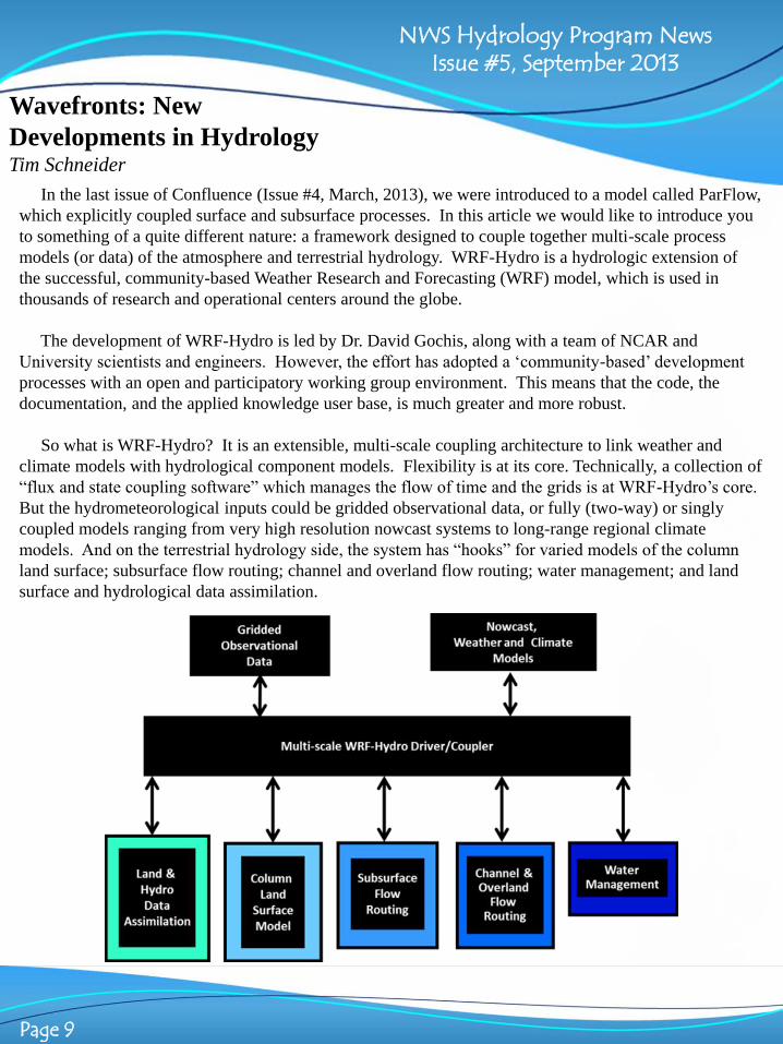
Construction of the approximately 65,000 square ft. National Water Center (NWC) facility in
Tuscaloosa, Alabama, is progressing toward completion. The design-build contractor for the project,
Triune-Beck, has largely completed brick installation, and window installation is nearing completion. Cast
stone columns have been constructed on the south face of the building. The focus of construction is now
centered on the interior of the facility. Work on domestic water lines electrical wiring, and plumbing is
well underway. Data cable is being pulled on all floors. Interior wall framing is complete except for a few
exceptions. The rotunda dome has been painted, and its copper roof installed. Sheetrock installation has
begun on all floors.
The NOAA Project Team (Office of the Chief Administrative Officer/Project Planning and Management
Division in Kansas City and the Office of Hydrological Development) conducted an extensive site review
the week of August 19. The tentative completion date of the NWC facility is October 2013, with
occupation expected in early 2014.
National Water Center Update Sam Contorno
Have an idea for an article for the next issue of Confluence? Please contact Katie Garrett at [email protected]. All articles for the next edition will be due on
Wednesday, November 20th. Confluence is now published quarterly.