Embed Size (px)
Citation preview

C O N C E P T U A L P L A N 2 0 1 5

C O N C E P T U A L P L A N 2 0 1 5


I am pleased to introduce you to the Riverfront Fort Wayne Conceptual Plan.
This plan is the result of a little over a year of extensive research, public engagement and hard work by experts, regional leaders and enthusiastic residents.
For years, economic development professionals and committed residents have dreamed of a vibrant riverfront. With the creation of the Legacy fund and partnerships with the Community Foundation of Greater Fort Wayne and the Allen County-Fort Wayne Capital Improvement Board, we’re ready to put our vision into action.
That vision is detailed in this Conceptual Plan. It provides the roadmap for where and how we work to revitalize our downtown riverfront. It envisions a riverfront with something for everyone –one that balances recreation, nature and development. Implementing this roadmap will take years, and no one knows exactly what the final result will look like.
But we do know that Riverfront Fort Wayne will be a catalyst for private investment and will offer yet another reason for people to live, work and play in the heart of our community. It will bring us closer to nature, connect us to our history and benefit generations to come.
I would like to extend my thanks to everyone who made this Plan possible. Thank you to the Riverfront Advisory Committee, several subcommittees that included community stakeholders and numerous City staff who guided the consultants and provided invaluable knowledge and insight, and the thousands of residents who helped shape the final result with their opinions and ideas. We’ve taken the first step in revitalizing our rivers and I look forward to the exciting journey ahead.
Thomas C. Henry, Mayor City of Fort Wayne
LETTER FROM THE MAYOR
R i v e R f R o n t f o r t way n e C O N C E P T UA L P L A N3

LETTER FROM THE RIVERFRONT ADVISORY COMMITTEE CO-CHAIRS
Welcome to the Riverfront Fort Wayne Conceptual Plan!
We are excited to present this final document to the public. It’s filled with information about current river conditions, as well as a vision for what’s possible along the Fort Wayne riverfront.
Before the riverfront consultants began their extensive research and public outreach, Fort Wayne Mayor Tom Henry appointed the Riverfront Advisory Committee (RAC) to oversee the process. The committee included residents with diverse backgrounds but a common goal – to set a vision for the downtown riverfront that would excite and engage people from all over northeast Indiana.
The vision outlined in this plan does just that. It challenges our community to create a riverfront that serves as a catalyst for economic development, while improving both the quality of life for area residents and the ecological conditions of the riverfront.
At each step of the process, the RAC reviewed research, best practices and proposals from SWA, the lead consultant on the project. We asked hard questions about everything from flooding to water quality to the market feasibility of housing and commercial projects. We pushed SWA to dream big, but also to make certain the vision reflected our community’s heritage and values.
Finally, we emphasized the importance of community input. Although the RAC represented a broad cross-section of area residents, we knew we couldn’t possibly understand everyone’s concerns and goals for the riverfront. When we asked for comments from the public, we were overwhelmed by the number and enthusiastic nature of the responses!
More than 1,100 people attended four public meetings, almost 3,000 people responded to electronic and paper surveys and approximately 200 comments were submitted through the Riverfront Fort Wayne website. Additionally, nearly 4,000 people took river boat rides during the Three Rivers Festival and approximately 500 people visited the Envision Fort Wayne Center to view displays and information about the riverfront efforts.
The vast majority of responses from the public were supportive of efforts to enhance our riverfront, and many people offered ideas that were incorporated into the recommended plans. Most respondents were in favor of creating a riverfront promenade as the central feature of the plan’s first phase.
Residents’ input and support, combined with thorough research of current riverfront conditions and exceptional guidance from talented professionals, helped create this conceptual master plan. We are proud of the efforts that resulted in this vision and we look forward to the work ahead.
Sincerely,
Karl Bandemer Raymond Kusisto Deputy Mayor, City of Fort Wayne CEO, Ortho NorthEast (“ONE”) RAC Co-Chair RAC Co-Chair
R i v e R f R o n t f o r t way n e C O N C E P T UA L P L A N 4

To establish a framework for action, to maximize the use and value of Fort Wayne’s rivers through increased recreational use, restoration, enhancement and development.
R I V E R F R O N T F O R T w A Y N E M I S S I O N
R i v e R f R o n t f o r t way n e C O N C E P T UA L P L A N5

To realize the value of reconnecting back to our rivers and riverfront areas as an economic and placemaking asset to the downtown, the community and the region.
R I V E R F R O N T F O R T w A Y N E V I S I O N
R i v e R f R o n t f o r t way n e C O N C E P T UA L P L A N 6

ACKNOwLEDGEMENTSC I T Y O F F O R T w A Y N E Mayor Thomas C. Henry
P R O j E C T T E A MPam HolocherSherese FortriedeDorothy HaganHolli Duncan Mary Tyndall Mary Jane Slaton Molly McCray
R E S O U R C E T E A M Kelly Bajic Anne Marie SmrchekAlec Johnson Kelly LynchBruce Kingsbury
R I V E R F R O N T A D V I S O R Y C O M M I T T E E ( R A C )Nick ArnettDave ArnoldKarl Bandemer (co-chair) Mark BeckerIan BoyceSteve BrodyTim HallPatti HaysLindsay Hively Nancy JordanRay Kusisto (co-chair)Jamie Lancia Greg Leatherman Dawn RosemondRick SamekTom SmithWendy SteinChad TownerRon TurpinJohn UrbahnsIrene WaltersDan Wire
S U B - C O M M I T T E E S * Architectural, Cultural, Historical and Archaeological Downtown and Economic Development Housing Outreach and Education Recreation, Parks and Public Lands Transportation, Accessibility and Connectivity Utilities, Environmental and Flooding C O N S U L T A N T T E A M SWA Market Feasibility AdvisorsMoffat & Nichol Amec Foster WheelerBiohabitatsMKM ArchitectsEmpower Results S P E C I A L T H A N K S Knight FoundationCapital Improvement BoardGrand Wayne CenterHilton HotelAllen County Public LibraryAIA Indiana – Fort WayneGreenbuild CouncilOrtho NorthEast (ONE)Dickmeyer Boyce Financial Management, Inc.ArtlinkFort Wayne Children ChoirHope Arthur OrchestraFort Wayne Outfitters and Bike DepotDon Hall’s RestaurantsScience CentralFort Wayne TinCapsEmbassy TheaterFort Wayne MetalsDowntown Improvement District
* Reference the appendix for a full list of each sub-committee’s members
R i v e R f R o n t f o r t way n e C O N C E P T UA L P L A N7

1 Executive Summary
2 Project Background
3 Planning, Design and Community Engagement Framework
4 Conceptual Plan
6 Phase 1
5 Next Steps
9
1 2
2 0
2 6
5 5
5 3
HISTORY OF FORT WAYNE’S RIVERS PLANNING CONTEXT: PREVIOUS STUDIESLOCAL CONTEXT: STUDY AREA ANALYSISEXISTING CONDITIONS REVIEW: OPPORTUNITIES AND CONSTRAINTS
STUDY PROCESS OVERSIGHTPLAN DEVELOPMENT GUIDANCEPLANNING PROCESS STAGES COMMUNITY ENGAGEMENT
CONCEPTUAL PLAN COMPONENTS CURRENT AND PROPOSED LAND USESARCHITECTURAL CHARACTER AND PLACEMAKINGCONNECTIVITY GREEN INFRASTRUCTURE IMPROVEMENT AREAS
PROJECT AREA LAND USESDEVELOPMENT STAGESECONOMIC PROJECTIONS
MAINTENANCE PLANPROGRAMMINGDEVELOPMENTRESOURCES PRELIMINARY COST ESTIMATES
CONTENTS
R i v e R f R o n t f o r t way n e C O N C E P T UA L P L A N 8

Cities with great waterfronts can often improve quality of life, retain and attract visitors and residents, and promote investment. Fort wayne has the potential to create a great waterfront that is truly a unique and world-class destination. The “window of opportunity” is open, the community is inspired and the conditions are right to make transformational changes now – it is Fort wayne’s time to shine.
The Riverfront Fort wayne Conceptual Plan focuses comprehensively on Fort wayne’s river system as a catalyst for development, while respecting and improving the environment and building on the local cultural history. The Plan is a design-focused vision that offers specific recommendations for the study area. Recommendations are centered on using Fort wayne’s rivers as a stimulus for creating new types of public spaces and bringing new private development to downtown Fort wayne. Further, the plan seeks to strengthen the identity of Fort wayne as a destination that encourages an active and healthy lifestyle, provides access to nature in the city and is proud of its history and excited for the future.
The planning process for the Riverfront Fort Wayne Study paired comprehensive public engagement with a design-driven approach. The goal of the process was to educate the public on the range of possibilities for Fort Wayne’s rivers and adjacent lands, while representing an authentic lifestyle and character. Ideas were tested with the public and those that resonated were advanced into the final
plan. The result is a plan that is not only feasible, but is supported by local residents.
The planning process was managed by the City’s Planning Department, while the design process was led by SWA, a national planning and design firm selected by the City through a request for proposal (RFP) process and a series of interviews. Their work was augmented with consultants that specialized in engineering, ecology, hydrology, architecture and economics. A public engagement specialist was hired separately to facilitate a public input process which ensured all residents had ample opportunity to share their ideas and make recommendations. The work of the consultant team was guided by the Riverfront Advisory Committee (RAC), a group comprised of civic and business leaders with a variety of backgrounds and expertise. The technical aspects of the work were further discussed by the technical subcommittees that were convened by the Planning Department.
The Riverfront Fort Wayne Conceptual Plan makes recommendations for the use and development of all land within the study area. The Conceptual Plan is intended to be a long-range vision for Fort Wayne’s downtown riverfront area. During the planning process the RAC requested that a Phase 1 project area be identified and addressed with more specificity. This detailed Phase 1 plan is included in Chapter 6 and foresees a 1 to 15 year implementation horizon. The ideal vision begins with the reawakening of the stunning natural resources surrounding the rivers. Native trees and wildflowers line the riverbanks providing a dense thicket of nature; fish and wildlife exist alongside a thriving city. Great swaths of nature are reestablished and maintained so that Fort Wayne’s residents and visitors see a city that
01 EXECUTIVE SUMMARY
P L A N N I N G P R O C E S S S U M M A R Y
P R O j E C T V I S I O N
P R O j E C T S T A T E M E N T
R i v e R f R o n t f o r t way n e C O N C E P T UA L P L A N9

is respectful of the environment from which it was formed. The vision for Fort Wayne’s riverfront is to create a “place of contrasts” where city and nature provide a diversity of experiences for the community - a place where numerous opportunities exist. The vision continues with urban public spaces that are crafted along the edges of the rivers to provide easy access to the rivers and become a catalyst for new residential and commercial development. Existing parks in the study area are strengthened to provide a richer experience to a broader cross-section of Fort Wayne residents, while the confluence of the three rivers is celebrated with a unique environmental art installation. Streetscapes and pedestrian connectivity are upgraded to create a catalyst for existing businesses while creating opportunities for new ventures. This new entertainment/retail district will thrive in the heart of Fort Wayne, where the development is respectful of nature, and serves as a regional draw for Northeast Indiana and beyond.
The following principles provided the framework for the plan. 1. Seek to balance ecology, recreation and the built environment.
2. Promote and support a variety of activities and uses that encourage people to live, invest, socialize and recreate on and along the rivers.
3. Celebrate and preserve the cultural history of the rivers. 4. Ensure creative, sustainable, authentic, high quality architecture and development.
5. Improve river water quality and enhance the riverfront environment. 6. Seek innovative and ecologically appropriate solutions to riverfront initiatives. 7. Increase connections between the rivers, the greenway, downtown and collar neighborhoods. 8. Provide, protect and improve public access along and to the rivers. 9. Create unique scenic opportunities to view the rivers. 10. Create a regional destination that is transformational for the City of Fort Wayne.
Implementation of the Riverfront Fort Wayne Conceptual Plan will begin with the area surrounding the historic Wells Street Bridge. The first steps include identifying and securing parcels that are needed for Phase 1 implementation and initiation of the schematic design for the promenade area. Parallel to these processes, public-private partnership opportunities should be pursued, along with additional funding sources. Once these priority steps are completed, a detailed design of public realm components of the Phase 1 project can begin. The creation of a management entity to oversee fundraising, implementation, programming and maintenance of the downtown riverfront should also be investigated and established. A significant portion of the Phase 1 detailed design effort will need to address Federal, State and local regulatory requirements.
01 EXECUTIVE SUMMARY
G U I D I N G P R I N C I P L E S
N E X T S T E P S
THE PROMENADE IS THE FIRST PHASE OF THE PLAN
R i v e R f R o n t f o r t way n e C O N C E P T UA L P L A N 10

01 EXECUTIVE SUMMARY
OVERALL CONCEPTUAL PLAN
R i v e R f R o n t f o r t way n e C O N C E P T UA L P L A N11

The Riverfront Fort Wayne Conceptual Plan was realized as a result of the Legacy Fort Wayne community initiative, which sought to determine the best investments for funds received as a result of proceeds of a long-term lease and recent sale of the City’s electric utility. The Legacy Fort Wayne Task Force created by Mayor Tom Henry in 2011, identified Fort Wayne’s downtown riverfront as a key opportunity area for investment. The Task Force recommended the Riverfront Fort Wayne Study as the first step to realizing the potential of the downtown riverfront area as a vibrant, regionally important destination on the north side of the City’s downtown.
This chapter presents a general overview of the study area and evaluation of site conditions. It is organized in the following sections:
• History of Fort Wayne’s Rivers• Planning Context: Previous Studies• Local Context: Study Area Analysis• Existing Conditions: Opportunities and Constraints
The three rivers existed in their current location long before there was a village, town or City of Fort Wayne. The St. Marys, St. Joseph and Maumee rivers were a natural transportation system that was used by Native Americans and later by French trappers, traders and soldiers. The Maumee River flows to Lake Erie and eventually to the Atlantic Ocean. A short portage west of Fort Wayne to the Wabash River allowed access to the Gulf of Mexico.
K E K I O N G A
The three rivers area was the home of the Myaamia Nation (Miami Tribe) prior to European contact. The key village was called Kekionga and is the site that would become Fort Wayne. Kekionga attracted French traders and both the French and British constructed forts in the area in the eighteenth century. After the American Revolution, it was uncertain whether the young United States would retain the Great Lakes region, or if it would become part of Canada due to British encroachment and Indian alliances. In 1794, President George Washington sent General Anthony Wayne to defeat the Native Americans at the Battle of Fallen Timbers near present-day Maumee, Ohio. The Americans then marched to Kekionga and established Fort Wayne at the confluence of the three rivers.
F O R T W A Y N E B E C O M E S A C I T Y
The rivers were the first transportation route to Fort Wayne, but by the mid-nineteenth century a canal and railroads also provided transportation of people and freight. Water power and good transportation routes allowed Fort Wayne to become a center of regional commerce and industry and the city’s population grew quickly. At the beginning of the twentieth century, Fort
02 PROjECT BACKGROUND
I N T R O D U C T I O N
O V E R V I E w
H I S T O R Y O F F O R T w A Y N E ’ S R I V E R S
R i v e R f R o n t f o r t way n e C O N C E P T UA L P L A N 12
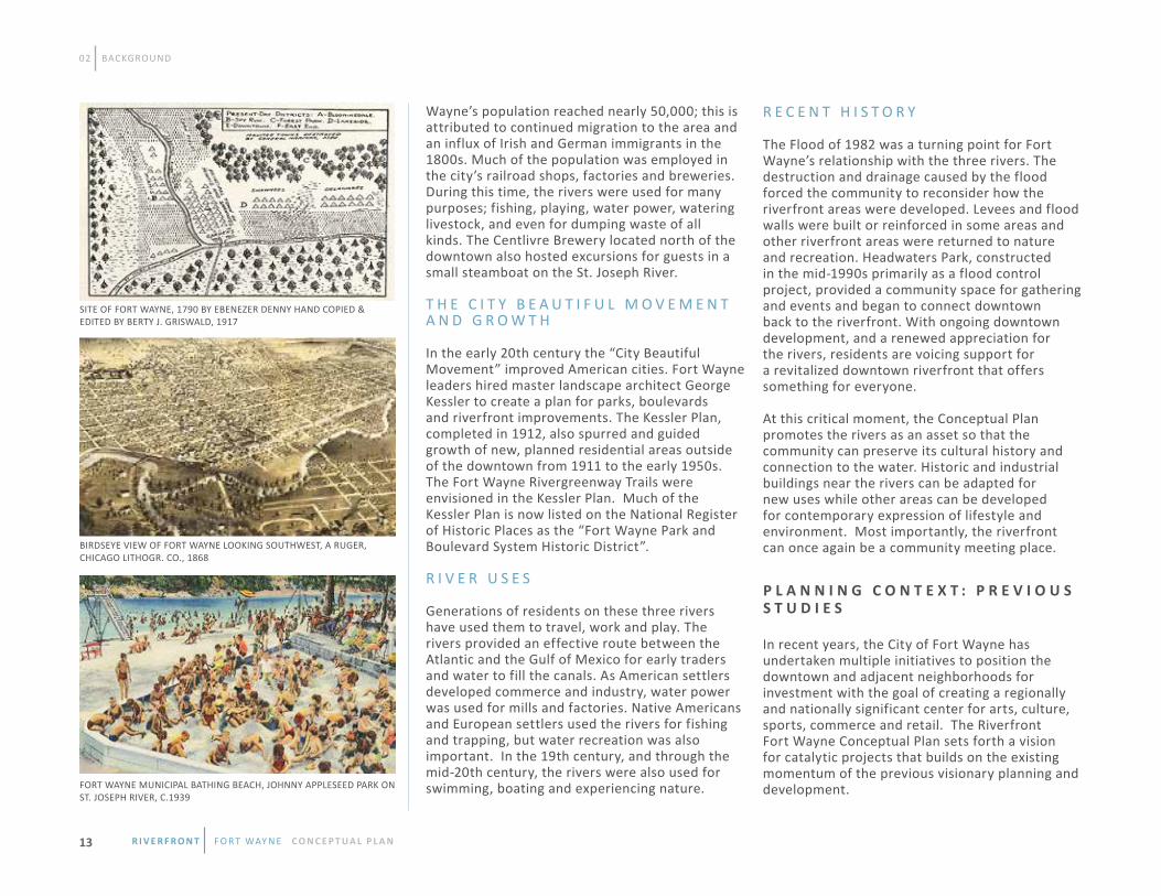
Wayne’s population reached nearly 50,000; this is attributed to continued migration to the area and an influx of Irish and German immigrants in the 1800s. Much of the population was employed in the city’s railroad shops, factories and breweries. During this time, the rivers were used for many purposes; fishing, playing, water power, watering livestock, and even for dumping waste of all kinds. The Centlivre Brewery located north of the downtown also hosted excursions for guests in a small steamboat on the St. Joseph River.
T H E C I T Y B E A U T I F U L M O V E M E N T A N D G R O W T H
In the early 20th century the “City Beautiful Movement” improved American cities. Fort Wayne leaders hired master landscape architect George Kessler to create a plan for parks, boulevards and riverfront improvements. The Kessler Plan, completed in 1912, also spurred and guided growth of new, planned residential areas outside of the downtown from 1911 to the early 1950s. The Fort Wayne Rivergreenway Trails were envisioned in the Kessler Plan. Much of the Kessler Plan is now listed on the National Register of Historic Places as the “Fort Wayne Park and Boulevard System Historic District”.
R I V E R U S E S Generations of residents on these three rivers have used them to travel, work and play. The rivers provided an effective route between the Atlantic and the Gulf of Mexico for early traders and water to fill the canals. As American settlers developed commerce and industry, water power was used for mills and factories. Native Americans and European settlers used the rivers for fishing and trapping, but water recreation was also important. In the 19th century, and through the mid-20th century, the rivers were also used for swimming, boating and experiencing nature.
R E C E N T H I S T O R Y
The Flood of 1982 was a turning point for Fort Wayne’s relationship with the three rivers. The destruction and drainage caused by the flood forced the community to reconsider how the riverfront areas were developed. Levees and flood walls were built or reinforced in some areas and other riverfront areas were returned to nature and recreation. Headwaters Park, constructed in the mid-1990s primarily as a flood control project, provided a community space for gathering and events and began to connect downtown back to the riverfront. With ongoing downtown development, and a renewed appreciation for the rivers, residents are voicing support for a revitalized downtown riverfront that offers something for everyone.
At this critical moment, the Conceptual Plan promotes the rivers as an asset so that the community can preserve its cultural history and connection to the water. Historic and industrial buildings near the rivers can be adapted for new uses while other areas can be developed for contemporary expression of lifestyle and environment. Most importantly, the riverfront can once again be a community meeting place. In recent years, the City of Fort Wayne has undertaken multiple initiatives to position the downtown and adjacent neighborhoods for investment with the goal of creating a regionally and nationally significant center for arts, culture, sports, commerce and retail. The Riverfront Fort Wayne Conceptual Plan sets forth a vision for catalytic projects that builds on the existing momentum of the previous visionary planning and development.
02 BACKGROUND
P L A N N I N G C O N T E X T : P R E V I O U S S T U D I E S
FORT WAYNE MUNICIPAL BATHING BEACH, JOHNNY APPLESEED PARK ON ST. JOSEPH RIVER, C.1939
SITE OF FORT WAYNE, 1790 BY EBENEZER DENNY HAND COPIED & EDITED BY BERTY J. GRISWALD, 1917
BIRDSEYE VIEW OF FORT WAYNE LOOKING SOUTHWEST, A RUGER, CHICAGO LITHOGR. CO., 1868
R i v e R f R o n t f o r t way n e C O N C E P T UA L P L A N13

02 BACKGROUND
Past and current City planning efforts have created an important foundation for the Conceptual Plan to build upon and have informed the design team’s knowledge of local issues and design approach. The studies reviewed as a part of the process are as follows: • Plan-It Allen: Comprehensive Plan (2007)•Downtown Fort Wayne: Blueprint for The Future (2002)• Downtown Fort Wayne: Blueprint Plus (2005)• Comprehensive Parks and Recreation Master Plan (2004)• 2013-2017 Parks and Recreation Master Plan (2013)• Northside Neighborhood Plan (2007)• Bloomingdale / Spy Run Neighborhood Plan (2005)• West Central Neighborhood Plan (2005)• Bike Fort Wayne: A Plan to Enhance Transportation Options (2010)• Walk Fort Wayne: A Plan to Enhance Pedestrian Accessibility (2011) • Front Door Fort Wayne: A Plan to Enhance our City’s Gateways (2012)• Downtown Stormwater/Sewer Master Plan (2011)• Combined Sewer Overflow Reduction Plan (2007)Implementation of the Conceptual Plan has the potential to have a significant positive impact on social, ecologic and economic activities within the study area and beyond. By referencing these studies and incorporating their recommendations into this study, the Plan will align and build upon past community based plans. While the ongoing planning and physical upgrades within the downtown will have the largest impact on the Riverfront Study Area, recent investment activity
and potential reinvestment areas along Wells Street corridor will also impact the study area and has been included for this reason. In 2014, the City, in partnership with Greater Fort Wayne Inc. and its Downtown Development Committee, began the process of updating the
Downtown BluePrint. The Riverfront Fort Wayne initiative is considered to be an important part of the future of the downtown area and its implementation priorities will be incorporated into the updated downtown plan.
50 ACRES
160 ACRES
100 ACRES
AERIAL MAP OF THE STUDY AREA
R i v e R f R o n t f o r t way n e C O N C E P T UA L P L A N 14
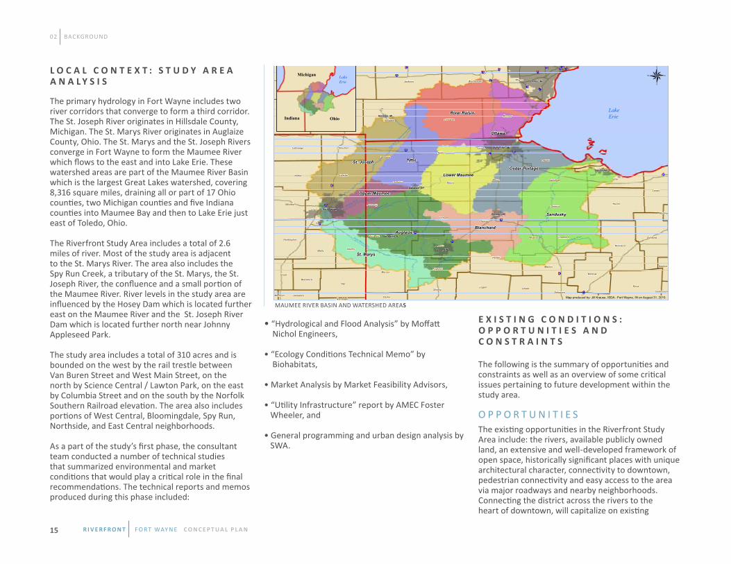
The primary hydrology in Fort Wayne includes two river corridors that converge to form a third corridor. The St. Joseph River originates in Hillsdale County, Michigan. The St. Marys River originates in Auglaize County, Ohio. The St. Marys and the St. Joseph Rivers converge in Fort Wayne to form the Maumee River which flows to the east and into Lake Erie. These watershed areas are part of the Maumee River Basin which is the largest Great Lakes watershed, covering 8,316 square miles, draining all or part of 17 Ohio counties, two Michigan counties and five Indiana counties into Maumee Bay and then to Lake Erie just east of Toledo, Ohio. The Riverfront Study Area includes a total of 2.6 miles of river. Most of the study area is adjacent to the St. Marys River. The area also includes the Spy Run Creek, a tributary of the St. Marys, the St. Joseph River, the confluence and a small portion of the Maumee River. River levels in the study area are influenced by the Hosey Dam which is located further east on the Maumee River and the St. Joseph River Dam which is located further north near Johnny Appleseed Park. The study area includes a total of 310 acres and is bounded on the west by the rail trestle between Van Buren Street and West Main Street, on the north by Science Central / Lawton Park, on the east by Columbia Street and on the south by the Norfolk Southern Railroad elevation. The area also includes portions of West Central, Bloomingdale, Spy Run, Northside, and East Central neighborhoods. As a part of the study’s first phase, the consultant team conducted a number of technical studies that summarized environmental and market conditions that would play a critical role in the final recommendations. The technical reports and memos produced during this phase included:
• “Hydrological and Flood Analysis” by Moffatt Nichol Engineers, • “Ecology Conditions Technical Memo” by Biohabitats, • Market Analysis by Market Feasibility Advisors, • “Utility Infrastructure” report by AMEC Foster Wheeler, and • General programming and urban design analysis by SWA.
The following is the summary of opportunities and constraints as well as an overview of some critical issues pertaining to future development within the study area. O P P O R T U N I T I E S The existing opportunities in the Riverfront Study Area include: the rivers, available publicly owned land, an extensive and well-developed framework of open space, historically significant places with unique architectural character, connectivity to downtown, pedestrian connectivity and easy access to the area via major roadways and nearby neighborhoods. Connecting the district across the rivers to the heart of downtown, will capitalize on existing
02 BACKGROUND
Auglaize
Sandusky
TiffinSt. Joseph
River Raisin
St. Marys
Blanchard
Lower MaumeeCedar-Portage
Ottawa
Upper Maumee
Auglaize River
Flatrock Creek
Detroit, MI
Toledo, OH--MI
Fort Wayne, IN
Lima, OH
Findlay, OH
Sandusky, OH
Defiance, OH
Hillsdale, MI
Van Wert, OH
Sandusky River
Lenawee
JacksonCalhounWayne
MonroeBranchHillsdale
Washtenaw
St. Joseph
Kalamazoo
§̈¦80
§̈¦94
§̈ ¦69
§̈¦71
§̈¦75
§̈¦30
§̈ ¦23
§̈¦I96
§̈¦ I275
§̈¦15
§̈¦469
§̈¦U12
§̈¦280
§̈¦24
§̈¦ S39
§̈ ¦I475
§̈¦14
§̈ ¦127 §̈¦S10
§̈¦I90
§̈¦ I194
§̈¦75 S
§̈¦94 B
§̈¦S153
§̈¦I375
Wood
Knox
Huron
Allen
Seneca
Hardin
Henry
Mercer
Erie
Logan
Fulton
PutnamHancock
Marion
Lucas
Richland
Morrow
Ashland
Williams
Defiance
Paulding
Auglaize
WyandotVan Wert Crawford
Lorain
Sandusky
Ottawa
Shelby UnionDelaware
Darke
Holmes
Coshocton
MedinaAllen
Jay
Wells
Noble DeKalb
Adams
Steuben
Whitley
LaGrange
Huntington
Grant
Blackford
DelawareRandolph
Madison
Saint Marys River
Maumee River
East Bran
ch Sa
int Jo
seph R
iver
®Michigan
OhioIndiana
Map produced by: Jill Krause, ISDA - Fort Wayne, IN on August 31, 2015.
Western Lake Erie Basin (WLEB)
Lake Erie
Lake Erie
MAUMEE RIVER BASIN AND WATERSHED AREAS
L O C A L C O N T E X T : S T U D Y A R E A A N A L Y S I S
E X I S T I N G C O N D I T I O N S : O P P O R T U N I T I E S A N D C O N S T R A I N T S
R i v e R f R o n t f o r t way n e C O N C E P T UA L P L A N15

efforts to enhance the downtown and its nearby neighborhoods. Some of the opportunities recognized through this study process are: 1 . T H E R I V E R SThe Riverfront Study Area includes three rivers in the heart of the city, which is something that makes Fort Wayne unique when compared to other communities in the region. The riverfront study promotes reestablishing a relationship with the rivers in a way that celebrates them as an untapped opportunity and as a regional recreational asset.
2 . L A N D O w N E R S H I PThe Riverfront Study Area is largely comprised of publicly-owned land. There are also several privately held parcels which are underutilized, primarily as a result of industrial uses which have left the area due to flooding events or changes in operations over the years. The combination of publicly-owned land and underutilized parcels creates areas ripe for reinvestment.
3 . O P E N S P A C E F R A M E w O R K Fort Wayne Parks and Recreation maintains several parks within the Riverfront Study Area - Guldlin Park, Bloomingdale Park East and West, Lawton Park, Headwaters Park East and West, and the Old Fort Park. Future improvements to Lawton, Bloomingdale East and West and Guldlin Park should seek to reinforce ecological, recreational and cultural continuity of the riverfront open space network.
4 . H I S T O R I C B U I L D I N G S , S T R U C T U R E S A N D A R E A L A N D M A R K S The Riverfront Study Area has several existing historic buildings, structures and landmarks that should be preserved as a part of the architectural and historical character of the riverfront area. Many of the existing structures were originally built for the commercial and industrial uses that historically existed within the downtown riverfront area and have been renovated and adaptively reused over time.
Historic structures and places which are Local Historic Districts and/or listed on the National Register of Historic Places: • The historic Wells Street Bridge, a whipple truss bridge built in 1884 over the St. Marys River, listed on the National Register of Historic Places - closed to traffic in the early 1980s and converted to a pedestrian bridge in the late 1990s;
• The Hugh McCulloch House, 616 West Superior Street - a Greek Revival house built in 1843, a Local Historic District and listed on the National Register of Historic Places, renovated for various institutional, office and residential uses over the years;
• The Fort Wayne Engraving Company, 120 West Superior - a two story industrial/commercial building built in 1929, a Local Historic District; renovated for office uses;
• The Canal House, (also known as the John Brown Stone Warehouse), 114 East Superior Street - built in 1852 adjacent to the Wabash and Erie Canal by John Brown, a stone mason and merchant, used the building as an office and storehouse for materials. It is a Local Historic District and listed on the National Register of Historic Places, renovated for office use in the mid-1970s and is currently vacant. It is the only remaining building in the area associated with the canal;
• The St. Marys, St. Joseph and Maumee Rivers and their adjacent floodway areas, along with Lawton, Bloomingdale East and West, and Guldlin Parks, were part of a plan developed by George Kessler in 1912 that envisioned a network of boulevards and parkways to connect parks and neighborhoods. These areas are now part of the Fort Wayne Park and Boulevard System Historic District listed on the National Register of Historic Places;
02 BACKGROUND
CANAL HOUSE, 114 E. SUPERIOR ST
FORT WAYNE ENGRAVING COMPANY BUILDING, 120 W. SUPERIOR ST.
HUGH MCCULLOCH HOUSE, 616 W. SUPERIOR ST.
HISTORIC WELLS STREET BRIDGE
R i v e R f R o n t f o r t way n e C O N C E P T UA L P L A N 16

02 BACKGROUND
• The City Light and Power Plant, at 1950 North Clinton Street, originally built in the early 1900s and rebuilt in 1929 as the city’s main publicly run electric utility, renovated as a science museum, part of the Fort Wayne Park and Boulevard System Historic District, listed on the National Register of Historic Places, (photo on page 29).
There are also several historic buildings and landmarks that are not officially listed as Local Historic Districts or listed on the National Register of Historic Places but are important to the architectural and historic character of the study area:
• The Cass Street Depot, 1004 Cass Street - built in 1889 as a New York Central Passenger Station; now the home of Fort Wayne Outfitters, (photo, p.29);
• The E.M. Baltes & Company, 312 South Harrison Street - a circa 1900 two-story commercial/ industrial building;
• The Fort Wayne Paper Box Company, 102 West Superior Street - a circa 1900 industrial building that was expanded in 1923, it is currently being renovated for loft-style residential units;
• The Indiana Textile Company, 235 East Superior - early 20th century warehouse building, renovated in the late 1990s as Club Soda, an upscale restaurant, (photo on page 29);
• The Northern Indiana Public Service Company - Gas Plant, 305 East Superior Street - built in 1908, was renovated in 1958 as Don Hall’s Old Gas House Restaurant; • The Three Rivers Water Filtration Plant, at the confluence of the three rivers - built in 1933 in the Collegiate Gothic architectural style; and
• The Historic Old Fort, Spy Run Avenue and the St. Marys River - built in 1976 as a replica of the original 1816 American Fort.
The Riverfront Conceptual Plan seeks to build on the unique character of these buildings, to create a destination that is authentic to Fort Wayne. For more information on Architectural Character and design recommendations, refer to the Architectural Character and Placemaking section of Chapter 4. 5 . C O N N E C T I V I T Y T O D O w N T O w N The Riverfront Study Area’s location on the north side of the downtown presents many opportunities to connect new development on the south and north sides of the river to the downtown area. Current revitalization efforts and new investment along Calhoun and Harrison streets include: The
Landing and Parkview Field, which present great opportunities to connect new development in the riverfront area to downtown Fort Wayne. Incorporation of the implementation priorities of this study into the Downtown BluePrint update will further reinforce the connection between the riverfront and downtown Fort Wayne. 6 . P E D E S T R I A N C I R C U L A T I O N The City has a system of recreation trails along the riverbanks, called the Rivergreenway, which consists of 25 miles of trails. It is considered the backbone of a growing network of more than 80 miles of multi-use trails in the city and county. Maintaining and
CURRENT CONNECTIVITY
R i v e R f R o n t f o r t way n e C O N C E P T UA L P L A N17

enhancing this network is integral to the Conceptual Plan as a way of reinforcing the existing system as well as making new critical connections along the downtown riverfront area. The existence of smaller block sizes within the core of Fort Wayne allows for easier pedestrian connectivity between the downtown and adjacent neighborhoods and the riverfront area. The provision of safe and comfortable pedestrian connections across the rivers is essential to the success of downtown riverfront development. Current pedestrian-only connections across the St. Marys River include the historic Wells
Street Bridge and the pedestrian bridge between the Old Fort and Headwaters Park. There is a pedestrian bridge that crosses the Spy Run Creek as it enters the St. Marys River near Lawton Park. Recent enhancements to the Martin Luther King Bridge included a separated multi-use path which has enhanced pedestrian connectivity between Headwaters Park and Lawton Park.
7 . V E H I C U L A R A C C E S S A N D C O N N E C T I V I T Y A network of parkways and boulevards connecting the city’s three rivers and Spy Run Creek to adjacent
neighborhoods and parks is part of George Kessler’s 1912 plan. The grid street network contains approximately 300 foot block sizes. Several major thoroughfares connect the south and north sides of the river in the study area including Van Buren Street/Sherman Boulevard, Wells Street, North Clinton Street, Spy Run Avenue and Columbia Street. The main vehicular north/south entry points into the study area are also prominent gateways into the City’s downtown area. Superior Street provides an east/west connector along the south side of the study area. C O N S T R A I N T S
The following is a summary of the main constraints on the future planning and development in the study area. For more detailed analysis, please refer to the full technical consultant reports in the the appendix. 1 . C O M B I N E D S E w E R O U T F A L L S A N D w A T E R Q U A L I T Y I S S U E SThe existing combined sewer systems within the downtown area were built over a century ago. In a combined system, stormwater is collected and conveyed via inlets, yard drains and catch basins into the existing combined sewer network. During severe rainfall events the existing interceptors in the area cannot handle the stormwater runoff, which results in combined stormwater and sanitary sewer entering the river via Combined Sewer Outfall locations (CSOs). There are 9 CSO locations within the study area. This system was developed to quickly move large volumes of water during and after a rain event to prevent or reduce possible flooding. While this is a benefit, water quality can be compromised during heavy precipitation events. The City of Fort Wayne is in the process of implementing a Long Term Control Plan to address combined sewer overflow requirements. A part of this plan includes the development of an underground tunnel system to
02 BACKGROUND
RIVERFRONT STUDY AREA CONSTRAINTS
EXISTING LEVEE CSO POINTS WATER FILTRATION PLANT FLOODWAY 100 YEAR FLOODPLAIN 500 YEAR FLOODPLAIN
R i v e R f R o n t f o r t way n e C O N C E P T UA L P L A N 18

reduce the number of CSO incidents from greater than 70 to less than four per year, which will greatly improve water quality. However, water quality within the river will likely remain an issue due to the impact of upstream runoff from agricultural operations within watershed areas. Additionally, local wild geese populations are believed to contribute to contaminant loadings in excess of permitted values. 2 . L A C K O F A Q U A T I C H A B I T A T In general, the three rivers within the project area have a poor aquatic habitat. This is primarily due to the effects of the Hosey Dam which artificially pools the water. The primary impacts of the pooling of water are the lack of riffles (rocky or sandbar areas lying just beneath the surface) under normal water conditions and a silt dominated bottom. Together, these have a negative impact on mussels and other aquatic organisms. Removing the Hosey Dam or replacing it with a different type of dam structure may not be an option due to costs and the need to maintain water levels for recreation. Other methods
to mitigate some of the negative impacts associated with the dam such as reducing, slowing and/or eliminating water drawdowns and integrating fish ladders to allow habitat to pass the dam should be explored. By reducing the impact of drawdowns, aquatic vegetation will have a better chance to become established and thrive. Aquatic vegetation provides food and habitat to wildlife, erosion control and improves water quality.
3 . F L O O D P L A I N , L E V E E S A N D E R O S I O N The majority of the study area lies within the 500 year floodplain, which is not locally regulated in terms of development. However, nearly half of the area lies within the 100 year floodplain which is regulated locally and by the Federal Emergency Management Agency (FEMA). New construction within the 100 year floodplain must be built above the 100 year flood level and/or consist of flood-durable materials. In locations where channel cross sections are altered to suit the riverfront development concept, corresponding alterations are likely to have to be made at other locations within the river system to mitigate the risk of any potential water level increase. Any proposed improvements will need to be performed in accordance with the Federal, State and local standards and regulations.
An existing levee system is in place on the north side of the St. Marys River as well as areas along the St. Joseph River and Spy Run Creek. These levees protect neighborhoods on the north side of the study area and have allowed the re-designation of areas previously defined as 100 year floodplain to 500 year floodplain. In some areas the location of the levee and floodwall on the top of the riverbank severely limits opportunities to view and access the rivers, especially from Bloomingdale Park. Any proposed modifications to the levee and floodwall system will need to be authorized and coordinated with the United States Army Corps of Engineers (USACE).
4 . S O I L T Y P E S A N D E R O S I O NWithin the Maumee watershed, both the St. Marys and St. Joseph Rivers have erosive soil types leading to high sediment loading in the study area. The lake-like condition created by the dams within the study area cause sediments to drop out of the slow-moving water and may increase the need for occasional dredging.
Riverbank erosion was noted in some locations within the study area. Specific areas that need to be addressed along the St. Marys River are adjacent to the Old Fort Park and Headwaters Park East. Riverbank erosion in these areas exists in part due to mowing and building too close to the water’s edge, a lack of vegetation and uprooted trees.
5 . I N V A S I V E S P E C I E S + L A C K O F B I O D I V E R S I T Y One of the key findings of the ecological conditions review was that several invasive species and pioneer species (which tend to colonize in disrupted or damaged areas) dominate the riparian (riverbank) areas. It was also noted that there is a lack of diversity in vegetation as a whole. Invasive plant species such as tree of heaven and bush honeysuckle dominate the corridor with bush honeysuckle completely dominating the understory layer. Efforts should be made to remove non-native species and replace them with native woody plants to ensure the aggressive invasive plants will not recolonize. From an ecologic standpoint, much of the habitat and open spaces along the rivers are too narrow and fragmented to provide a robust ecological system. Future riverfront improvements should expand and connect these spaces for recreational enjoyment, habitat richness, and bio-diversity. The completion and implementation of the Riparian Management Plan will specifically evaluate the river corridor within the study area and provide a action plan for specific areas.
02 BACKGROUND
RIVER BANK EROSION, ST. MARYS RIVER AT OLD FORT SITE
R i v e R f R o n t f o r t way n e C O N C E P T UA L P L A N19

03 PLANNING, DESIGN AND COMMUNITY ENGAGEMENT FRAMEwORK
The planning and design process was performed over a 13-month time frame which began in December 2013. This schedule allowed the consulting team the time needed to complete a comprehensive review of the study area and allowed for various opportunities for public education and input on the evolving Conceptual Plan. The City of Fort Wayne Planning and Policy Department facilitated and managed the study process, whcih was overseen by an advisory committee appointed by Mayor Henry. Technical sub-committees were also created to review and advise on technical aspects of the consultant’s work. The outcome of the process was a Conceptual Plan, design proposals and action steps that the community understood and enthusiastically supported. This chapter describes the planning, design, and community engagement framework in the following sequence:
• Study Process Oversight • Plan Development Guidance • Planning Process Stages• Community Engagement
Riverfront Advisory Committee (RAC):Mayor Henry appointed twenty one community stakeholders to represent the community interests and assist in guiding the planning process. The RAC met several times during the plan development process to review the consultant team’s work and recommendations and provide detailed feedback. RAC members also participated in the Technical sub-committees to maximize efforts on various key themes.
Technical Sub-Committees:The following sub-committees were set up based on topical areas and comprised nearly 100 professional experts, City and County staff, RAC members and interested community members: • Architectural, Cultural, Historical and Archaeological• Environmental, Utilities, and Infrastructure • Parks and Recreation• Transportation and Connectivity • Regulatory• Housing • Downtown and Economic Development and • Public Outreach and Education. The sub-committees met several times during the study process to review information and provide the consultant team important technical information, context and background for the planning process. The plan development process began with the establishment of vision and mission statements which worked together to set forth the overall purpose and goal of the Riverfront Fort Wayne planning initiative. Further guidance was provided early in the planning process through the development of guiding principles and design
I N T R O D U C T I O N S T U D Y P R O C E S S O V E R S I G H T
O V E R V I E w
P L A N D E V E L O P M E N T G U I D A N C E
R i v e R f R o n t f o r t way n e C O N C E P T UA L P L A N 20

principles to ensure that decisions made during the planning process reflected community priorities. The vision and mission statements, along with the guiding and design principles, were endorsed and embraced by the RAC and consistently repeated in community and group presentations. Together, these statements will continue to provide guidance as the Conceptual Plan is implemented.
V I S I O N To realize the value of reconnecting back to our rivers and riverfront areas as an economic and placemaking asset to the downtown, the community and the region.
M I S S I O N
To develop a framework for action to maximize the use and value of Fort Wayne’s rivers through increased recreational use, restoration, enhancement and development. G U I D I N G P R I N C I P L E S Presented to the RAC and the public, the guiding principles were used by planning and consulting teams to ensure that decisions made during the study process reflected community priorities.
1. Develop the downtown riverfront district so it is a balance of ecology, recreation and the built environment.
2. Promote and support a variety of activities and uses that encourage people to live, invest, socialize and recreate on and along the rivers.
3. Celebrate and preserve the cultural history of our rivers. 4. Ensure creative, sustainable, authentic, high- quality architecture and development.
5. Improve river quality and enhance the riverfront environment.
6. Seek innovative and ecologically appropriate solutions to river and riverfront initiatives.
7. Increase connections between the rivers, the greenway, downtown and collar neighborhoods.
8. Provide, protect and improve public access along and to the rivers.
9. Create unique scenic opportunities to view the river.
D E S I G N P R I N C I P L E S
The following design principles were developed by the consulting team through research of the study area and observations about the City of Fort Wayne and how it can best leverage its riverfront as a catalyst for development and growth. Presented to the RAC and the public,the design principles were used by the design team to ensure that all components of the Conceptual Plan work together to create cohesive and unique places.
1 . A U T H E N T I C The principle of authenticity is used to define the character of design elements and the type of programming that will be generated for the various components of the Conceptual Plan. Design elements will be created from materials that are historically or typically used in the local vernacular region so that the projects are grounded in the region. These materials will be utilized and assembled in a contemporary fashion using the most up-to-date and appropriate design form. Programming of public spaces will be based on creating activities that residents from Fort Wayne are most interested in or that complement activities that are already occurring.
03 PLANNING METHODOLOGY
PROMOTE RIVERFRONT ACTIVITIES
IMPROVE RIVER qUALITY
UNIqUE SCENIC OPPORTUNITIES
R i v e R f R o n t f o r t way n e C O N C E P T UA L P L A N21

03 PLANNING METHODOLOGY
2 . R E S I L I E N T Projects constructed along river systems require special considerations to make them work with the natural forces and dynamic fluctuations in waterways. Local impacts of the projects within the Riverfront Study Area are taken into account along with the potential regional impacts of upstream changes to the watershed. This approach extends into the design of open spaces by reducing the dependence on irrigation and intensive maintenance requirements by using native plant materials and well-adapted species and materials. A resilient approach that works with nature rather than against it is employed throughout the plan.
3 . R I P A R I A N The word riparian means “relating to, or situated on the banks of a river.” The design of the Conceptual Plan includes a riparian landscape so that habitat and biodiversity extend into development parcels, neighborhoods and infrastructure. Examples of riparian landscapes include the use of riparian plant species for street trees and storm water collection systems that use appropriate plants to cleanse urban runoff.
4 . C O M P A C T To support the mission of creating a downtown riverfront area where residents are invested in a happy, healthy lifestyle, the plan endorses the use of compact development strategies. Small, walkable blocks, an emphasis on pedestrian and bicycle infrastructure, and mixed-use development will help make the downtown riverfront area attractive and user-friendly to residents and visitors. 5 . R I V E R C U L T U R E Fort Wayne is seeing a surge in river related activities and a growing interest in spending time along the riverbanks. The Conceptual Plan includes special places along the river that will foster and accommodate this more active lifestyle, while
providing quiet spaces for learning about and viewing native plants and wildlife. A river culture can be strengthened and promoted through the implementation process by giving priority or incentives to projects that provide amenities and accommodations to river-related activities.
6 . S U S T A I N A B L E In the context of design principles, sustainable initiatives will result in built places that reduce or reuse materials, lessen energy loads and consider locally sourced materials. The Conceptual Plan also takes advantage of existing habitat, and enhances and reconstructs new ecological areas along the rivers and within development areas.
The planning process was broken into four stages of work with the early stages providing background and foundation for the plan, and the later stages showing increasing levels of detail culminating in the final Conceptual Plan. For additional detail on the process refer to the Community Engagement and Process Stratigies of the appendix. The four stages of work are described as follows:
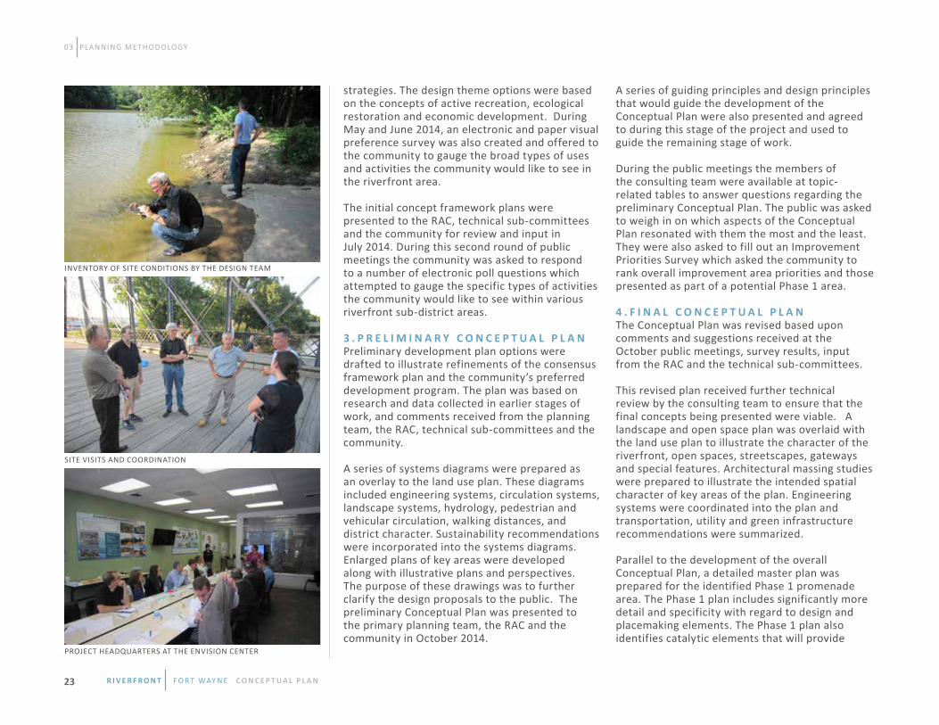
1 . I N I T I A L A S S E S S M E N T S A N D T E C H N I C A L S T U D I E S This stage of work involved mobilization of the consultant team, gathering and synthesizing previous studies, site visits to document existing conditions and the creation of base maps for use in developing the Conceptual Plan. It also included gathering community input regarding hopes and concerns regarding riverfront development.
To initiate the project, a three-day work session was held in Fort Wayne. During this time the consultant team met with the primary City planning team to establish the goals and objectives of the plan. Meetings and interviews were held with project participants including City staff, the
Riverfront Advisory Committee and community stakeholders. Technical meetings were held with the technical sub-committees comprised of interested experts and community members.
Following the start-up meetings, the consultant team documented in graphic form the existing environmental, cultural and economic factors that would affect development of the study area. A summary of the key opportunities, constraints and the most relevant influences on the development of the study area were outlined. Benchmarking data of comparable projects in similar cities was also collected and used to inform the primary planning team and the public about the range of opportunities that could be considered.
Based upon the site analysis and team meetings, a context analysis was prepared that related future development to the surrounding area. Significant connections were studied so that the study area would be considered an integral part of the broader community. The context analysis considered land use, transportation systems, open spaces, infrastructure and utilities.
Technical memoranda were prepared by the consultant team. These studies created the foundation for the Conceptual Plan. Studies were focused on market analysis, ecology, hydrology and utility infrastructure. A summary of the studies are described below. For more detailed analysis, please refer to the full consultant technical memos of the appendix. 2 . I N I T I A L C O N C E P T S Once the initial assessment and technical studies were complete, the design team used this information to create a series of development program options and framework diagrams which explored a variety of land uses and amenities. The development options ranged from conservative to aggressive in order to test a range of ideas and
P L A N N I N G P R O C E S S S T A G E S
R i v e R f R o n t f o r t way n e C O N C E P T UA L P L A N 22
03 PLANNING METHODOLOGY
strategies. The design theme options were based on the concepts of active recreation, ecological restoration and economic development. During May and June 2014, an electronic and paper visual preference survey was also created and offered to the community to gauge the broad types of uses and activities the community would like to see in the riverfront area.
The initial concept framework plans were presented to the RAC, technical sub-committees and the community for review and input in July 2014. During this second round of public meetings the community was asked to respond to a number of electronic poll questions which attempted to gauge the specific types of activities the community would like to see within various riverfront sub-district areas.
3 . P R E L I M I N A R Y C O N C E P T U A L P L A NPreliminary development plan options were drafted to illustrate refinements of the consensus framework plan and the community’s preferred development program. The plan was based on research and data collected in earlier stages of work, and comments received from the planning team, the RAC, technical sub-committees and the community.
A series of systems diagrams were prepared as an overlay to the land use plan. These diagrams included engineering systems, circulation systems, landscape systems, hydrology, pedestrian and vehicular circulation, walking distances, and district character. Sustainability recommendations were incorporated into the systems diagrams. Enlarged plans of key areas were developed along with illustrative plans and perspectives. The purpose of these drawings was to further clarify the design proposals to the public. The preliminary Conceptual Plan was presented to the primary planning team, the RAC and the community in October 2014.
A series of guiding principles and design principles that would guide the development of the Conceptual Plan were also presented and agreed to during this stage of the project and used to guide the remaining stage of work.
During the public meetings the members of the consulting team were available at topic- related tables to answer questions regarding the preliminary Conceptual Plan. The public was asked to weigh in on which aspects of the Conceptual Plan resonated with them the most and the least. They were also asked to fill out an Improvement Priorities Survey which asked the community to rank overall improvement area priorities and those presented as part of a potential Phase 1 area. 4 . F I N A L C O N C E P T U A L P L A NThe Conceptual Plan was revised based upon comments and suggestions received at the October public meetings, survey results, input from the RAC and the technical sub-committees.
This revised plan received further technical review by the consulting team to ensure that the final concepts being presented were viable. A landscape and open space plan was overlaid with the land use plan to illustrate the character of the riverfront, open spaces, streetscapes, gateways and special features. Architectural massing studies were prepared to illustrate the intended spatial character of key areas of the plan. Engineering systems were coordinated into the plan and transportation, utility and green infrastructure recommendations were summarized.
Parallel to the development of the overall Conceptual Plan, a detailed master plan was prepared for the identified Phase 1 promenade area. The Phase 1 plan includes significantly more detail and specificity with regard to design and placemaking elements. The Phase 1 plan also identifies catalytic elements that will provide
INVENTORY OF SITE CONDITIONS BY THE DESIGN TEAM
SITE VISITS AND COORDINATION
PROJECT HEADqUARTERS AT THE ENVISION CENTER
R i v e R f R o n t f o r t way n e C O N C E P T UA L P L A N23

momentum to envisioning the overall Conceptual Plan. Preliminary cost estimates for public sector improvements based on the Conceptual Plan are included in the Phase 1 plan.
The final Conceptual Plan was presented at the “Big Reveal” public meeting held on February 4, 2015. The meeting was attended by more than 400 people and included a video summary of the final Conceptual Plan, a presentation by the consulting team and a gallery of renderings. Reference Chapter 5 for complete details of the final plan. Engaging and educating the community was a priority and overarching theme throughout the study process. An internal Communications Team which included an outside communications consultant, Empower Results, guided community engagement and outreach efforts in consultation with SWA. The Public Outreach and Education sub-committee assisted the Communications Team with outreach and education efforts in preparation for public meetings, electronic survey initiatives and events. For more detailed information on community engagement efforts, please refer to the “Community Engagement” section of the appendix.
As previously mentioned, a public input meeting was held at each of the four stages of the study process. In total the public meetings were attended by over 1,150 people. During the public meetings the attendees were asked to provide specific input in various ways including comment cards, electronic polling, writing comments on display walls and face-to-face interaction with the staff and the consulting team. In addition to public meetings, further input was obtained through two electronic and paper surveys. The first survey asked the community about the types of uses and activities they would like to see in the riverfront area and it received
over 2,500 responses. The second asked more specifically about improvement priorities for specific areas along the riverfront as well as for the proposed Phase 1 area of the study and received over 1,250 responses.
The City, through a grant from the Knight Foundation, established a public engagement center called the Envision Fort Wayne Center (Envision Center). This storefront space, which opened in March 2014, is located in the core of downtown and acted as a continuous open house with electronic and static displays focused on the Riverfront Fort Wayne initiative. The Envision Center encouraged the community to come in during regularly scheduled hours and was also available for special community group meetings and class trips. During the riverfront study process the Envision Center hosted hundreds of visitors.
In July 2014, project staff developed scripts and participated as docents for Riverboat Excursions during the Three Rivers Festival. The Communications Team also set up an information tent about the Riverfront Fort Wayne initiative. The event was very popular with nearly 4,000 people getting out on the river over a weekend.
In October 2014, the Communications Team organized a series of River Walks which included area architects who volunteered their time to create renderings of participant’s ideas for riverfront amenities and development at certain locations. Participant feedback was recorded by staff during the walks and forwarded to the consulting team. In January 2014, in anticipation of the final “Big Reveal” presentation, a Riverfront Fort Wayne Photo Contest was developed in partnership with Artlink Contemporary Gallery. During the contest, participants were invited to share their favorite Fort Wayne river-related photos through Facebook, Twitter and Instagram. There were 192
INTERACTIVE TOOLS FOR INTERPRETING THE COMMINITY’S VISION
PUBLIC MEETINGS PRESENTATION DISPLAY
PUBLIC MEETINGS PRESENTATION
C O M M U N I T Y E N G A G E M E N T
03 PLANNING METHODOLOGY
R i v e R f R o n t f o r t way n e C O N C E P T UA L P L A N 24
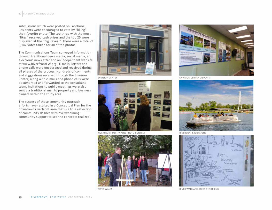
submissions which were posted on Facebook. Residents were encouraged to vote by “liking” their favorite photo. The top three with the most “likes” received cash prizes and the top 25 were displayed at the “Big Reveal”. There were a total of 3,142 votes tallied for all of the photos.
The Communications Team conveyed information through traditional news media, social media, an electronic newsletter and an independent website at www.RiverfrontFW.org. E-mails, letters and phone calls were encouraged and received during all phases of the process. Hundreds of comments and suggestions received through the Envision Center, along with e-mails and phone calls were documented and forwarded to the consultant team. Invitations to public meetings were also sent via traditional mail to property and business owners within the study area.
The success of these community outreach efforts have resulted in a Conceptual Plan for the downtown riverfront area that is a true reflection of community desires with overwhelming community support to see the concepts realized.
03 PLANNING METHODOLOGY
ENVISION CENTER ENVISION CENTER DISPLAYS
RIVERFRONT FORT WAYNE PHOTO CONTEST RIVERBOAT EXCURSIONS
RIVER WALKS RIVER WALK ARCHITECT RENDERING
R i v e R f R o n t f o r t way n e C O N C E P T UA L P L A N25

04 CONCEPTUAL PLAN The Riverfront Fort Wayne Conceptual Plan is the culmination of months of research, community outreach and design. The concepts generated in this plan have been informed by the vision for development and they identify locations for specific project elements. This chapter summarizes the proposed elements of the Conceptual Plan in the following sequence:
• Conceptual Plan Components• Current and Proposed Land Uses• Architectural Character and Placemaking• Connectivity• Green Infrastructure• Improvement Areas
The Conceptual Plan proposes development, recreation and ecological improvements that bring the community to the rivers. Primary strategies within the Conceptual Plan create a series of catalytic projects that build on one another while taking advantage of a growing appreciation of Fort Wayne’s rivers, culture and quality of life.
Development projects propose a promenade with new residential, retail and dining experiences. New active and highly programmed parks offer activities for all age groups and personal fitness levels, while passive trails and recreation areas provide access to nature within the heart of the city’s downtown area. Improvements to the riparian habitat within the area provide a balance of improvements in the river system, construct new types of ecological systems in key locations and open viewsheds and access throughout the area.
The Riverfront Study Area has been divided into five improvement areas. These include: • Riverfront Promenade/Headwaters Junction • Bloomingdale / Guldlin Nature Parks and Downtown Environmental Center
• Superior Street Corridor • Lawton Adventure Park
• Sphere of Confluence and The Old Fort In addition to proposing various types of development within each of the five areas, the Conceptual Plan addresses a connectivity strategy throughout the overall area and from the downtown to adjacent neighborhoods. A primary connection will be the installation of a promenade along both north and south banks of the St. Marys River.
I N T R O D U C T I O N C O N C E P T U A L P L A N C O M P O N E N T S
O V E R V I E w
R i v e R f R o n t f o r t way n e C O N C E P T UA L P L A N 26

04 CONCEPTUAL PLAN
Two lake areas have also been proposed within the Conceptual Plan and are placed on the edge of Lawton and Guldlin/Bloomingdale Parks. Details of the recommended improvements within each area are discussed in this chapter.
Current land uses within the Riverfront Study Area are dominated by open space, government owned parcels and vacant lands. Some commercial establishments are located in the study area, but few benefit from or take advantage of their proximity to the river. Most current residential uses within the area are located north of the river. The planning process determined that the uses within the Riverfront Study Area should maintain a balance of nature, recreation and development. The result is a plan that maintains open space as the dominate
land use within the area. The Conceptual Plan then envisions changes to other land use patterns resulting from improvements to the public realm that are focused on reconnecting the city to the rivers. Upgrades to Superior Street and the riverfront in the vicinity of Harrison Street are proposed to increase commercial land uses. By providing new public and private amenities, an increase in residential land uses could also be achieved within the study area. Placemaking utilizes a local community’s assets and potential to create comfortable public spaces that people enjoy. Architectural character is one of the defining qualities of a successful public space. The overall shape, materials, craftsmanship, decorative details, and relationship between the interior and exterior spaces of buildings and structures have a major effect on how people relate to their
environment. This section is intended to set the framework for the design of new development and public spaces within the downtown riverfront area by: • Defining the historic context and development patterns of the study area and offering design guidance.
• Celebrating the unique character of Fort Wayne and the rivers.
• Encouraging social interaction and community gathering spaces.
• Providing a variety of spaces for multiple types of activities and age groups.
C U R R E N T A N D P R O P O S E D L A N D U S E S
A R C H I T E C T U R A L C H A R A C T E R A N D P L A C E M A K I N G
CURRENT LAND USE PROPOSED LAND USE
SINGLE-FAMILYMULTI-FAMILYCOMMERCIALGOVERNMENTINDUSTRYPARKS/OPEN SPACEVACANTRAILROAD
R i v e R f R o n t f o r t way n e C O N C E P T UA L P L A N27

H I S T O R I C C O N T E X T The historic buildings and structures that remain in the Riverfront Study Area represent the commercial enterprises and industries that relied on the rivers, canal and rail lines located in the area. These buildings and structures provide a distinct link to local history that enhances the unique character of the riverfront area. Several are listed on the National Register of Historic Places and/or as Local Historic Districts. With a diversity of design styles and materials, they should be referenced as inspiration for the design of new buildings along the riverfront. While the details of these buildings vary, certain characteristics are common such as the use of durable stone and brick exterior materials and a high proportion of wall to glass surface. Historic buildings should not be faithfully copied but should be used as inspiration for compatible contemporary architecture which will enhance the unique character of Fort Wayne. It is recommended that these historic resources be retained through restoration and adaptive reuse where possible. The following list highlights some of the significant historic buildings and structures within the Riverfront Study Area. A full listing of Historic Structures, Places and Area Landmarks can be found in Chapter 2.
• Hugh McCulloch House, 616 West Superior Street
• Cass Street Depot, 1004 Cass Street
• E.M. Baltes & Company, 312 South Harrison Street
• Historic Wells Street Bridge
• Fort Wayne Engraving Company, 120 West Superior Street
• Fort Wayne Paper Box Company, 102 West Superior Street
• Canal House, (also known as the John Brown Stone Warehouse), 114 East Superior Street • City Light and Power Plant, 1950 North Clinton Street
• Indiana Textile Company, 235 East Superior Street
• Northern Indiana Public Service Company-Gas Plant, 305 East Superior Street
• Three Rivers Water Filtration Plant
H I S T O R I C D E V E L O P M E N T P A T T E R N S
The early plats of Fort Wayne were laid out using a standard grid pattern of city blocks subdivided by alleys. The layout was influenced by the location of existing streets and the rivers, which meant that the grid was not always in a true north-south direction. Urban buildings were primarily at least two stories, built to the sidewalk and generally occupied the full width of the lot. This characteristic provided a consistent building wall along streets which created a dense, walkable urban environment. Many of the buildings in the riverfront area have been removed and replaced with parking or greenspace due to flooding issues. The Conceptual Plan recommends placing new construction in the open street frontages along Superior Street, and within the promenade areas on the north and south sides of the river, in order to reestablish a dense walkable environment and provide connections to the downtown area. Historically, development along the rivers had frontages on the adjacent streets and the backs of the buildings faced the river. In order to activate the riverfront area, it is strongly recommended that buildings built in the riverfront areas face the river as well as the adjacent streets and provide connectivity to both the streets, rivers and promenades/rivergreenway trails.
04 CONCEPTUAL PLAN
FORT WAYNE OUTFITTERS - CASS STREET DEPOT
CLUB SODA - INDIANA TExTILE COMPANY
SCIENCE CENTRAL - CITY LIgHT AND POWER PLANT
R i v e R f R o n t f o r t way n e C O N C E P T UA L P L A N 28
P L A C E M A K I N G E L E M E N T S
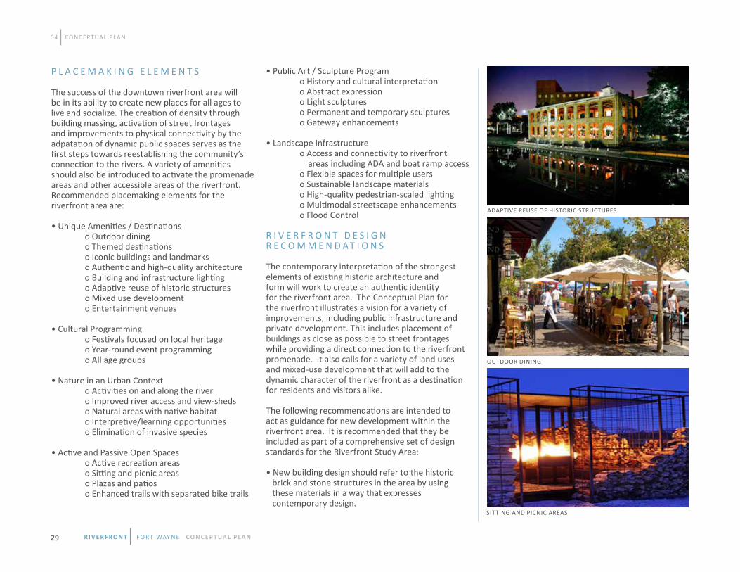
The success of the downtown riverfront area will be in its ability to create new places for all ages to live and socialize. The creation of density through building massing, activation of street frontages and improvements to physical connectivity by the adpatation of dynamic public spaces serves as the first steps towards reestablishing the community’s connection to the rivers. A variety of amenities should also be introduced to activate the promenade areas and other accessible areas of the riverfront. Recommended placemaking elements for the riverfront area are:
• Unique Amenities / Destinations o Outdoor dining o Themed destinations o Iconic buildings and landmarks o Authentic and high-quality architecture o Building and infrastructure lighting o Adaptive reuse of historic structures o Mixed use development o Entertainment venues • Cultural Programming o Festivals focused on local heritage o Year-round event programming o All age groups
• Nature in an Urban Context o Activities on and along the river o Improved river access and view-sheds o Natural areas with native habitat o Interpretive/learning opportunities o Elimination of invasive species
• Active and Passive Open Spaces o Active recreation areas o Sitting and picnic areas o Plazas and patios o Enhanced trails with separated bike trails
• Public Art / Sculpture Program o History and cultural interpretation o Abstract expression o Light sculptures o Permanent and temporary sculptures o Gateway enhancements
• Landscape Infrastructure o Access and connectivity to riverfront areas including ADA and boat ramp access o Flexible spaces for multiple users o Sustainable landscape materials o High-quality pedestrian-scaled lighting o Multimodal streetscape enhancements o Flood Control R I V E R F R O N T D E S I G N R E C O M M E N D A T I O N S
The contemporary interpretation of the strongest elements of existing historic architecture and form will work to create an authentic identity for the riverfront area. The Conceptual Plan for the riverfront illustrates a vision for a variety of improvements, including public infrastructure and private development. This includes placement of buildings as close as possible to street frontages while providing a direct connection to the riverfront promenade. It also calls for a variety of land uses and mixed-use development that will add to the dynamic character of the riverfront as a destination for residents and visitors alike. The following recommendations are intended to act as guidance for new development within the riverfront area. It is recommended that they be included as part of a comprehensive set of design standards for the Riverfront Study Area:
• New building design should refer to the historic brick and stone structures in the area by using these materials in a way that expresses contemporary design.
04 CONCEPTUAL PLAN
ADAPTIVE REUSE OF HISTORIC STRUCTURES
OUTDOOR DINING
SITTING AND PICNIC AREAS
R i v e R f R o n t f o r t way n e C O N C E P T UA L P L A N29

• Building facade materials should consist of low- reflectivity glass, brick, limestone, wood, metal, terra cotta, sandstone, concrete and marble. • The ground floor of buildings with commercial space should contain large storefront display windows along street frontages. • The upper levels of buildings should contain balconies especially for residential and hotel uses.
• Building heights should be tiered and established to maximize views to the river within the Riverfront Study Area. • Commercial space should occupy the ground floor of new structures, particularly in the Phase 1 area and along Superior Street. • Awnings and canopies are recommended to provide shade to pedestrians and outdoor dining along street frontages and promenade areas. • Sidewalks should be designed to be wide enough to accommodate pedestrian traffic and outdoor dining spaces.
• A street-tree planting program should be established in the study area.
• green infrastructure and other innovative stormwater management solutions should be encouraged as a part of streetscape, public space and private development design.
• Pedestrian scaled lighting is encouraged as a part of streetscape, public space and private development design.
• New development adjacent to the river should have primary facades, entrances and pedestrian connectivity from the street and the riverfront frontages.
• Public spaces are envisioned to be primarily constructed of durable materials such as concrete, steel, stone and brick. This section examines the aspects of access and circulation for the future vision for the Riverfront Study Area. The Conceptual Plan details components of existing and proposed pedestrian/bicycle, vehicular and public transit circulation and envisions physical connection to the river through proximity, visual cues and placemaking. The transformation of selective land forms and clearings will open views to the rivers and bring the community closer to the water’s edge. The diagrams to the right depict various edge treatments that provide connectivity to the river’s edge. Connectivity is encouraged by introducing links to destinations within the riverfront area from the adjoining neighborhoods and downtown. Creating environments that are friendly to pedestrians, cyclists and drivers will increase access of the riverfront as a destination. A variety of activities and programing as well as providing comfortable and frequent places to sit, converse and gather will contribute to the success of the area. In particular, the Conceptual Plan proposes establishing better connections across the rivers, through parks and public spaces, and ensuring that all spaces are accessible to a variety of physical abilities and age groups. PEDESTRIAN/BICYCLE CIRCULATION
Fort Wayne has a significant number of dedicated trails and pedestrian paths for recreation, leisure, and daily commuting activities. Three designations of paths work together to meet the needs of pedestrians and cyclists: • Trails focus on multi-purpose recreation;
04 CONCEPTUAL PLAN
RIVERFRONT TRAILS + PROMENADE
UNDULATING PROMENADE
PROMENADE + TERRACES
C O N N E C T I V I T Y
RIVER EDGE TREATMENTS FOR CONNECTIVITY
R i v e R f R o n t f o r t way n e C O N C E P T UA L P L A N 30

• Primary pedestrian pathways that link destinations in the community to one another, and; • Secondary pedestrian pathways that link smaller gathering spaces together.
The Rivergreenway Trail system is a community asset that currently serves as a popular recreational and commuter connection for pedestrians and cyclists alike. The Conceptual Plan proposes increasing the existing trail system to provide contiguous access to and through the riverfront area from the surrounding neighborhoods and downtown. Trails designated for bikes only and pedestrians only should be considered during implementation, as these will create a safe and enjoyable environment and minimize barriers to exercise for all users. At key places, pedestrians should feel free to stroll or pause along the trail without interfering with the movement of faster moving bikes. These places add interest to the trail and enhance the visitor experience. Pedestrian pathways provide an effective and safe way to move throughout the entire riverfront area. Primary pathways are centralized, typically wider than secondary pathways and should provide direct connections to the various destinations within the riverfront. Primary pathways may or may not be alongside a street and indicate options to cross over to secondary pathways. The historic Wells Street Bridge could serve as a primary pathway intersection that connects the north and south promenades. Secondary pathways are the walks that move visitors throughout the riverfront area which are narrower than the primary pathways, and draw people into specific locations and attractions.
The Conceptual Plan proposes to enhance existing bridges and build new pedestrian bridges that provide multiple connections across the rivers throughout the area. Existing bridges that focus on moving vehicular traffic through the area should include options to modify them and include
RECREATION TRAIL / BIKE PATH
PRIMARY PEDESTRIAN PATHS
SECONDARY PEDESTRIAN PATHS
PROPOSED PEDESTRIAN BRIDGES / BRIDGE ENHANCEMENTS
PROPOSED PEDESTRIAN / BIKE NETWORK
04 CONCEPTUAL PLAN
HARRISON STREET ENHANCEMENTS WITH RE-PURPOSINg OF EXISTING BUILDINGS
REINFORCING CONNECTION FROM HISTORIC WELLS STREET BRIDGE TO SUPERIOR STREET
R i v e R f R o n t f o r t way n e C O N C E P T UA L P L A N31

pathways for safe usage for pedestrians. The construction of new pedestrian bridges, specifically across Spy Run Creek and around the confluence, provides multiple connection points from adjacent neighborhoods and offers better access for residents to the riverfront. Regardless of designation, pathways should be lively, dynamic and energized. Wider sidewalks and uniquely designed bridges will help to attract people to explore and enjoy the urban fabric of the area. First floor commercial uses should contain retail stores and restaurants to provide opportunities for window shopping and dining. Suggested priorities for pedestrian improvements include the planting of street trees that continue the connection to riparian zones, using industrially influenced materials, ensuring active first floor uses, strategically placing street furniture and installing improved lighting. V E H I C U L A R N E T W O R K S
Vehicular networks and driver experiences are defined by roadway characteristics such as speed, lane width and elements within the public right-of-way. While certain traffic engineering standards must be addressed, the introduction or elimination of various elements in the right-of-way will improve visibility, decrease the likelihood of speeding and reduce collisions. To achieve these measures, the Conceptual Plan proposes enhancements that include revising street widths, altering on and off street parking and adding streetscape elements that include cohesive selection and placement of trees and lighting fixtures. The existing street network offers multiple points of entry to the riverfront area. The Conceptual Plan suggests the closure of Fourth Street to make way for improvements through Lawton Park, while re-establishing Tennessee Street as an east west connector between Bloomingdale and Spy Run neighborhoods. Additional street closures include segments of Wells Street, north and south
04 CONCEPTUAL PLAN
EXISTING STREETS TO REMAIN
EXISTING STREETS TO BE REMOVED
NEW STREETS
PROPOSED STREETSCAPE ENHANCEMENTS
PROPOSED VEHICULAR NETWORK
of the historic Wells Street Bridge, First Street and Commerce Drive. The Conceptual Plan proposes additions to the residential street grid on either side of Wells Street to promote better circulation to and along the north promenade area. The proposed streetscape enhancements mentioned previously should be considered along Clinton, Wells and Superior streets. T R A N S I T
Transit within the study area currently services multiple routes along some north and south bound arterial roads. While this current transit service provides north/south connectivity between the Riverfront Study area, downtown,and beyond, east/west connectivity does not currently exist within the riverfront area. The existing transit experience in the Riverfront Study area could be improved
by providing enhanced transit stops with themed shelters identifying with the riverfront. Walking distance maps and wayfinding features would provide information to transit users about how close various destinations are to their current location. Establishing transit improvements, along with creating a pedestrian friendly environment, will make the area seem more compact and easily accessible without a vehicle. A riverfront/downtown circulator should also be considered which would link primary downtown destinations with proposed destinations in the study area. This localized transit system could extend the entertainment experience for residents, workers and visitors. For example, a connection from the baseball stadium to waterfront dining destinations would create growth oppotunities for both destinations.
R i v e R f R o n t f o r t way n e C O N C E P T UA L P L A N 32

04 CONCEPTUAL PLAN
The use of Green Infrastructure (GI) techniques as a part of the management of stormwater in streetscapes, public spaces and private development can provide a unique opportunity to educate the public on the importance of appropriate techniques that can benefit the river system by improving water quality and reducing the amount of stormwater runoff.
The figure on the right outlines the location of the “complete streets” and/or living streets and also provides an outline of the impervious surface that can potentially be managed by permeable pavement, cisterns or green roofs. The gI alternatives presented represent just a few of the options that may be considered for stormwater quality and quantity management. Each area within the Riverfront Conceptual Plan will have its own aesthetic which will lend itself to the type of gI to be used. There are many times when the most sustainable way to address a problem is to use a “gray” infrastructure option. gray infrastructure generally refers to hard traditional infrastructure such as concrete gutters, storm sewers, culverts and detention basins. gray options do not necessarily mean that a solution is not “green,” rather it means that sometimes the best stormwater control measure for a project is something sustainable and appropriate for the application and design of a particular project. gray options may allow for creative, non-traditional water features in areas that may have space or other limitations. Often times a combination of green and gray infrastructure is the most effective.
During the detailed design of each riverfront area, the selected consultant will be responsible for identifying water quality and quantity management opportunities and options to address them. Water quality and quantity management have not always been considered together, but GI and other
alternative and sustainable strategies inherently tie these concepts together. In many instances, the opportunity to reduce runoff and localized flooding at a property level may be tied to the construction of a GI feature. There are many gI options that may be suitable for the riverfront area depending on the site. The three most common practices are highlighted in the images on the next page. All have been successfully constructed in the City of Fort Wayne and are working effectively. gI applications, such as tree boxes, that do not comply with City policies are not discussed here. In the areas where the environmental center and other “natural” designs are planned, constructed wetlands and other similar designs are applicable and should be considered. Rain gardens and bioswales allow for stormwater
conveyance in large areas that can have park-like settings. They may also be used in or around parking areas to help manage stormwater runoff and improve water quality. Rain gardens can look “weedy” if planted too diversely, but with proper design and limited plant selection, can be an attractive part of a development. Green roofs are a type of GI that can be used when space is limited and there are minimal opportunities to manage stormwater runoff. green roofs have been successfully used worldwide to help reduce the amount of runoff generated by a building. Costs for green roofs vary significantly, but in general are higher than a traditional roof. The offset is that green roofs typically last much longer than a traditional roof. A green roof also helps lower carbon footprints and heat island effects and is a great source of LEED points if applying for certification.
EXISTING IMPERVIOUS SURFACE
PROPOSED IMPERVIOUS SURFACE
STREETS WITH GREEN INFRASTUCTURE
1200’
5010’
2940’ 2690’
1900’
1900’
850’
PROPOSED GREEN INFRASTUCTURE IMPROVEMENTS
G R E E N I N F R A S T R U C T U R E
R i v e R f R o n t f o r t way n e C O N C E P T UA L P L A N33

EXAMPLE OF A BIOSWALE
EXAMPLE OF PERVIOUS PAVERS
EXAMPLE OF A GREEN ROOF
Pervious pavement or pavers provide opportunities to manage stormwater quantity and quality. Pervious pavement does not require dedicated green space. It is typically used in areas where parking occurs, such as parking lots or the parking lane of a street. The groundwater table will dictate how much stormwater storage can occur and the soil type will help determine how quickly water will infiltrate. Costs for pervious pavement are significantly higher than traditional road costs, but the need for detention may be reduced or eliminated depending on the amount of storage below the pavement. As new development projects progress, consultants and staff should note that gI and other nontraditional water quality designs may require routine maintenance. In some instances, it can require more frequent maintenance and different types of maintenance activities may be warranted. gI techniques such as rain gardens and bioswales take time to establish and, if not properly cared for, can look weedy and collect large amounts of trash, debris and sediment. Typical activities for maintenance can include debris/trash removal, mulch/soil replacement, weeding, watering to establish plants, etc. Some types of GI techniques such as pervious pavement need to be vacuumed annually in order to remove the buildup of sediment. A maintenance staff hired exclusively for the riverfront area should have the skills to maintain GI within streetscapes and public spaces. When properly installed and cared for, GI adds value to public spaces and private development both aesthetically and economically and should be considered as a part of new development projects within the riverfront area. For additional information on the recommended GI for the riverfont area reference Amec Foster Wheeler’s techincal memo of the appendix.
04 CONCEPTUAL PLAN
R i v e R f R o n t f o r t way n e C O N C E P T UA L P L A N 34

04 CONCEPTUAL PLAN
I M P R O V E M E N T A R E A S The following describes the proposals for each of the five improvement areas within the Riverfront Study area. Each improvement area provides a narrative of its existing conditions and the proposed improvements, along with the specific recommendations to achieve these improvements. R I V E R F R O N T P R O M E N A D E / H E A D W A T E R S J U N C T I O N The St. Marys River between Ewing Street and Headwaters Park is fairly narrow and lined with a thin band of riparian vegetation. The river banks are steep and in some places erosion of the banks has occurred. The south side of the river is lined with light industrial buildings while much of the north side of the river is lined with a levee. The Pepsi facility is a significant feature of the north side, however there is also much open space and undeveloped land in this reach of the river. The historic Wells Street Bridge is located in the center of this area, and the Cass Street Train Depot, which houses the Fort Wayne Outfitters, is nearby. This section of the river has been identified as the heart of the riverfront area due to its ease of connectivity to downtown via Harrison Street and Calhoun Street. A mixed-use destination development, paired with a community promenade is planned for both sides of the river. The development will feature retail, dining, entertainment and residential land uses. Cultural facilities that celebrate Fort Wayne’s industrial past are proposed to include Headwaters Junction, a historic railroad experience with interpretive exhibits.
The north side of the river will offer a soft native landscape with trails complemented by rest areas under shade structures. The open space will be anchored by a large stepped and floating deck
designed to be a great civic space along the river. The deck will be a gathering spot with access to the river for canoeing, kayaking or people watching. The historic Wells Street Bridge serves as the center piece for the project and connects various activities on both sides of the river.
The south side promenade will connect Guldlin Park to the west and Headwaters Park to the east; it will then cross over the river on a pedestrian bridge and eventually reach Lawton Park. The vision of the south promenade between Harrison and Ewing Streets is comprised of lounge decks and plazas with a variety of places for shopping, dining and entertainment. Features within this section of the promenade, such as fountains, public art, lighting displays and music should highlight an active waterfront. R E C O M M E N D A T I O N S 1 . D E V E L O P T H E S O U T H S I D E P R O M E N A D E A N D P R E P A R E D E V E L O P M E N T S I T E S The south side promenade, from the historic Wells Street Bridge to Headwaters Park West, should be developed as a public space that is lined with retail and restaurants that offer outdoor dining opportunities and is animated by public art, water features and lighting. Development sites should be prepared in parallel with the promenade’s construction.
2 . S E L E C T D E V E L O P E R A N D C O N S T R U C T E N T E R T A I N M E N T R E T A I L P R O j E C T F O R S O U T H S I D E Developers should be provided with development guidelines for architecture and a preferred retail mix. Selected developers should be encouraged to work in parallel to the design and construction of the south side promenade so that the promenade and development are opened in tandem.
R i v e R f R o n t f o r t way n e C O N C E P T UA L P L A N35

NORTHSIDE DECK AND BOAT LAUNCH
SOUTH PROMENADE PLAzA
EVENT PLAzAS WITH RETAIL
3 . A D A P T I V E R E U S E O F B U I L D I N G S A N D N O R T H S I D E R E S I D E N T I A LOlder buildings within the area should be considered for adaptive reuse as creative office spaces, residential loft apartments, restaurants or retail shops. Reuse of these buildings and infill with contemporary buildings will be key to creating an authentic riverfront environment. New residential construction should be considered on the north side of the river. The buildings should be of a scale that works with the existing neighborhood, and should consider using sustainable design criteria.
4 . D E V E L O P T H E N O R T H S I D E D E C K A N D P R O M E N A D E C O N N E C T I O N S T O L A w T O N P A R K A community deck on the north side of the river should complement the activities proposed for the south side promenade. The shopping experience along the north side deck should consist of kiosks or small scale retail shops. The north side promenade should span the distance between Bloomingdale and Lawton parks, offering visitors a seamless connection along the entire northern portion of the riverfront area.
5 . H E A D w A T E R S j U N C T I O N The proposed Headwaters Junction project could provide the riverfront area with a themed entertainment attraction that is authentic to Fort Wayne’s rail history. This attraction is planned to include a museum with interpretive displays, a café and a unique opportunity to experience the historic 765 steam engine up close. Weekend, holiday and evening dinner trips would be offered throughout the year. A business plan and feasibility study will be developed to lay the groundwork for this project to move forward.
04 CONCEPTUAL PLAN
R i v e R f R o n t f o r t way n e C O N C E P T UA L P L A N 36

04 CONCEPTUAL PLAN
6 . H A R R I S O N S T R E E T B R I D G E E N H A N C E M E N T S A N D H I S T O R I C w E L L S S T R E E T B R I D G E P E D E S T R I A N P A T H w A Y Enhancements to the Harrison and Wells street bridges will provide pedestrians with strong connections between the north and south side riverfront promenades. Upgrades to Harrison Street are proposed to include removing one traffic lane and retrofitting the space with a linear pedestrian plaza on the west side of the bridge. Shade structures and seating have also been proposed so that people can view the riverfront. This will extend the pedestrian connectivity from downtown and across the river to Bloomingdale neighborhood. To fully utilize the pedestrian connection of the historic Wells Street Bridge, it is proposed to close off the vehicular roads directly north and south of the bridge and create a pedestrian pathway that extends from Superior Street through to Wells Street. This could be designed as flexible open space to host a variety of events. 7 . P U B L I C A R T A curated public art and sculpture program is also envisioned along the riverfront with installations that could be permanent or temporary. Light sculptures along the promenade and over the river will also enhance the evening experience and district identity.
HARRISON BRIDGE ENHANCEMENTS
R i v e R f R o n t f o r t way n e C O N C E P T UA L P L A N37

04 CONCEPTUAL PLAN
1
2
7
7
9
8
3
4
4
5
6
LOUNGE DECKS OVER AND AROUND WATER
ENTERTAINMENT DECK OVER WATER
ACTIVE DECK WITH WATER FEATURE
SERIES OF PLAzA SPACES ALONG PROMENADE
HISTORIC WELLS STREET BRIDGE PEDESTRIAN WALKWAY
PEDESTRIAN BRIDGE LINKING HEADWATERS PARK TO PROMENADE AND TRAILS
REST zONES WITHIN LANDSCAPE
FLOATING STEP DECK AND BOAT DOCK
HEADWATERS JUNCTION
RIVERFRONT PROMENADE/ HEADwATERS jUNCTION
12
7
9
8
3
4
5
6
R i v e R f R o n t f o r t way n e C O N C E P T UA L P L A N 38

04 CONCEPTUAL PLAN
B L O O M I N G D A L E / G U L D L I N N A T U R E P A R K S A N D D O W N T O W N E N V I R O N M E N T A L C E N T E R
guldlin Park is comprised of a low floodplain on an inside bend on the south side of the St. Marys River. The park is dominated by a large field, thick riparian vegetation, and a boat launch. Properties south of Michaels Drive were purchased by the City of Fort Wayne as part of a federal buyout program due to persistent flooding within the area, therefore precluding new structures on these lots. The Hugh McCulloch home and property is adjacent to the park. Historically, the park area would have been used for agricultural purposes.
Bloomingdale Park is located on the north side of the river, across from Guldlin Park. The park itself is separated from the river by a low levee and thick riparian vegetation. Bloomingdale East is generally a passive recreation space, while Bloomingdale West contains a basketball court and children’s play structure and serves as a neighborhood park. A parking lot located within Bloomingdale West provides access to a trailhead for the St. Marys Pathway, which is part of the Rivergreenway trail system. A rail spur just north of the park is proposed to connect Headwaters Junction to the main rail line.
Several areas along the St. Marys River, within the study area, are identified as floodplain forests with the largest being located along Bloomingdale and Guldlin Parks. The Conceptual Plan looks to take advantage of this existing natural habitat and create an ecologically based park that treats these floodplain forests along the two sides of the river as a single park. The Conceptual Plan takes advantage of guldlin Park’s low elevation within the floodplain by creating a series of wetlands and aquatic habitat. The Conceptual Plan also proposes a Downtown Environmental Center, which provides educational opportunities to the community and can be
connected to the river’s edge with trails and boardwalks. The nearby Hugh McCulloch House could also be incorporated into the park and enhanced by an urban garden zone that extends to the south and connects with the trails to the north.
The spaces along the north side of the river are proposed to be designed to connect Bloomingdale Park down to the river by relocating the existing levees further to the north. The Conceptual Plan seeks to take advantage of the park’s higher elevation and proposes the installation of observation decks and towers connected by trails and paths. It is suggested to widen the river in this area to create a lake environment that provides enhanced recreation and biodiversity to the river system. The northern edge of the park could offer a cafe and a public pavilion space that reinforces connections with the surrounding community.
R E C O M M E N D A T I O N S 1 . D E V E L O P T H E D O w N T O w N E N V I R O N M E N T A L C E N T E R The Downtown Environmental Center can offer educational opportunities about the ecosystem of the rivers and the roles of personal stewardship within the watershed system. The facility itself can provide interpretative and interactive displays, indoor and outdoor classrooms, office space, a small theater and banquet facility. The proposed location of the facility, within this Conceptual Plan, would possibly require the facility to be built on piers due to its location within the floodplain. 2 . C O N S T R U C T A T R A I L A N D O B S E R V A T I O N S Y S T E MSeveral trails and paths are suggested throughout the parks so that visitors can enjoy the natural landscape through various points of interest. An upland trail is proposed along the top of the new levee, while a new riverside path provides visitors the option to stroll within close proximity to the
BLOOMINGDALE PARK
GULDLIN PARK
R i v e R f R o n t f o r t way n e C O N C E P T UA L P L A N39
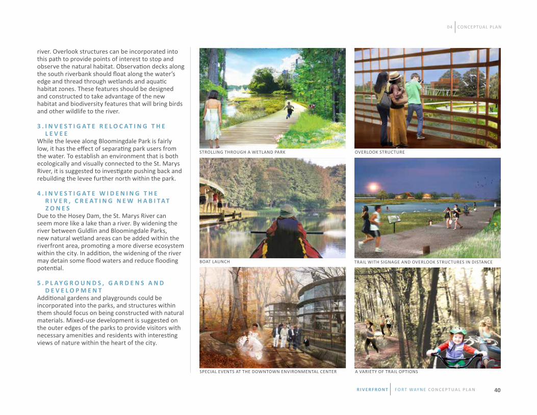
04 CONCEPTUAL PLAN
BOAT LAUNCH
SPECIAL EVENTS AT THE DOWNTOWN ENVIRONMENTAL CENTER
VIEW #5
A VARIETY OF TRAIL OPTIONS
OVERLOOK STRUCTURE
TRAIL WITH SIGNAGE AND OVERLOOK STRUCTURES IN DISTANCE
river. Overlook structures can be incorporated into this path to provide points of interest to stop and observe the natural habitat. Observation decks along the south riverbank should float along the water’s edge and thread through wetlands and aquatic habitat zones. These features should be designed and constructed to take advantage of the new habitat and biodiversity features that will bring birds and other wildlife to the river.
3 . I N V E S T I G A T E R E L O C A T I N G T H E L E V E EWhile the levee along Bloomingdale Park is fairly low, it has the effect of separating park users from the water. To establish an environment that is both ecologically and visually connected to the St. Marys River, it is suggested to investigate pushing back and rebuilding the levee further north within the park.
4 . I N V E S T I G A T E w I D E N I N G T H E R I V E R , C R E A T I N G N E w H A B I T A T Z O N E S Due to the Hosey Dam, the St. Marys River can seem more like a lake than a river. By widening the river between Guldlin and Bloomingdale Parks, new natural wetland areas can be added within the riverfront area, promoting a more diverse ecosystem within the city. In addition, the widening of the river may detain some flood waters and reduce flooding potential. 5 . P L A Y G R O U N D S , G A R D E N S A N D D E V E L O P M E N TAdditional gardens and playgrounds could be incorporated into the parks, and structures within them should focus on being constructed with natural materials. Mixed-use development is suggested on the outer edges of the parks to provide visitors with necessary amenities and residents with interesting views of nature within the heart of the city.
STROLLING THROUGH A WETLAND PARK
R i v e R f R o n t f o r t way n e C O N C E P T UA L P L A N 40

WEL
LS ST
REET
SHER
MAN
STR
EET
VAN BUREN
SUPERIOR STREET
1
1
2
2
7
7
11
11
10
10
9
9 15
15
16
16
12
12
13
13
14
14
8
8
3
3
4
4
5
5
6
6
NATURE PLAYGROUND
CAFE / RESTROOMS / MEETING SPACE
RAIL SPUR TO HEADWATERS JUNCTION
MIXED USE DEVELOPMENT
CHARIS HOUSE
RECREATION / BIKE TRAIL / NEW LEVEE LOCATION
OVERLOOK STRUCTURES
EPHEMERAL WETLANDS / VERNAL POOLS
PASSIVE PARK SPACE
RIVERSIDE PATH
EXISTING BOAT RAMP
DOWNTOWN ENVIRONMENTAL CENTER
INTERPRETIVE GARDENS
OBSERVATION DECKS
HUGH MCCULLOCH HOUSE
MULTI-FAMILY RESIDENTIAL
BLOOMINGDALE PARK
GULDLIN PARK
04 CONCEPTUAL PLAN
BLOOMINGDALE/GULDLIN NATURE PARKS AND DOwNTOwN ENVIRONMENTAL CENTER
R i v e R f R o n t f o r t way n e C O N C E P T UA L P L A N41

04 CONCEPTUAL PLAN
S U P E R I O R S T R E E T C O R R I D O R Superior Street parallels the railroad tracks along the southern edge of the Riverfront Study Area, between Van Buren Street to the west and Spy Run Avenue to the east. The Allen County Correctional Facilities is a significant structure along Superior Street and is located in the central section of the corridor. Don Hall’s Gas House, The Deck, Club Soda and the Three Rivers Apartment complex anchor the eastern end of the street. The western end of the street is anchored by a newly installed roundabout, the Hugh McCulloch House and opportunity areas.
Superior Street is important as the primary east-west thoroughfare roadway on the south side of the riverfront area. The proposal for the Superior Street corridor is to narrow the roadway width and increase the pedestrian zone, which will establish the area as a walkable destination through a series of interventions that brand the street and the new riverside development. The improvements to the corridor should also incorporate a riparian planting scheme that collects stormwater and provides biodiversity for the area. This unique planting character can be combined with street furnishings, lighting and other features to create a special identity for this part of the city.
Additional parking for the riverfront area could be accommodated by new parking structures within the lots between Superior Street and the railroad elevation. A long-term proposal for upgrading the Superior Street corridor is the relocation of the Allen County Correctional Facilities to a more suitable location outside of the riverfront area.
R E C O M M E N D A T I O N S 1 . R E D U C E D R I V E L A N E w I D T H S A N D I N C R E A S E P E D E S T R I A N A R E A S Superior Street should be re-engineered to reduce the street width and provide spaces for pedestrians and the addition of on-street parking. Traffic studies will need to be conducted to ensure an adequate level of service. The spaces between the street and the buildings should be designed as a pedestrian friendly streetscape with sustainable and attractive stormwater management features. The installation of lighting, wayfinding and branding elements that are unique to the riverfront can further identify the district. 2 . P A R K I N G S T R A T E G YEstablishing a parking strategy for the area, including a substantial amount of shared parking along the Superior Street corridor, should be studied further. This plan proposes the addition of parking garages that will accommodate new proposed development and make it easier for smaller retail stores to relocate and/or open in the area.
SUPERIOR STREET ENHANCEMENTS WITH RETAIL, RESTAURANTS AND BIKE LANES
R i v e R f R o n t f o r t way n e C O N C E P T UA L P L A N 42

04 CONCEPTUAL PLAN
3 . R E L O C A T E T H E A L L E N C O U N T Y C O R R E C T I O N A L F A C I L I T I E SThe Allen County Correctional Facilities are a set of significant structures within the study area. Alternatives for a better use of the property should be addressed when discussing the long-term growth of the riverfront. If the operations of the facility are moved, it is proposed that the building should be adaptively reused as rental housing with commerical space on the ground floor, or razed and re-developed as an iconic new mixed-use building or complex.
SUPERIOR STREET ENHANCEMENTS
R i v e R f R o n t f o r t way n e C O N C E P T UA L P L A N43

04 CONCEPTUAL PLAN
1
23
45
SUPERIOR STREET CORRIDOR
12345
HEADWATERS PARK
ALLEN COUNTY CORRECTIONAL FACILITY
RIVERFRONT PROMENADE SOUTH
STREETSCAPE IMPROVEMENTS ON SUPERIOR STREET
PARKING GARAGES ON SUPERIOR STREET
R i v e R f R o n t f o r t way n e C O N C E P T UA L P L A N 44

04 CONCEPTUAL PLAN
L A W T O N A D V E N T U R E P A R K Lawton Park is located on the north side of the St. Marys River and is bound by Clinton Street to the west and Spy Run Creek to the east. The park’s current condition is primarily dominated by passive open space, as well as three baseball diamonds, a children’s play area and a skateboard park. On the north side of the park are greenhouses and storage yards for the Parks and Recreation Department. Just north of those facilities lies a partially decommissioned electrical substation and Science Central. Science Central is a regional education/entertainment destination providing inspiring hands-on science education for children and adults. While Lawton Park is adjacent to the St. Marys River, views of it are largely obstructed by dense vegetation and a tall fence that surrounds the skate park.
The proposal for Lawton Park is to create a new type of adventure park for the City of Fort Wayne. The improved park should be a highly-programmed public space that offers visitors a wide variety of activities. Bocce ball, public gardens, obstacle courses, adventure play, picnic pavilions, a public beach, boat launch, zip lines and an improved skate park are envisioned. While Headwaters Park is focused on passive open space and special events, Lawton will be an adventure park with activities throughout the year.
R E C O M M E N D A T I O N S 1 . E X P A N D O N T H E S U C C E S S O F S C I E N C E C E N T R A LA science and ecology themed adventure play space is envisioned adjacent to Science Central. This facility will be a revenue-generating opportunity and will be programmed to work with Science Central’s suite of activities, possibly re-using the existing sub-station structure.
2 . E N H A N C E S P Y R U N C R E E K A R E AThe Spy Run Creek area should be enhanced to improve fish habitat, and include trails, interpretive elements and observation towers. Trails should connect with the Riverfront Promenade and the Greenway Trail system. zip lines could cross the creek as part of the adventure play area and obstacle course within the park.
3 . P R O G R A M P A R K S P A C E SA series of outdoor rooms, gardens, pavilions and other facilities should be developed to accommodate a diverse range of park activities. These activities should be designed to create an engaging and active park that fosters a healthy community. Amenities within the park could include cafes, boat rental facilities, and farmer’s market stalls. The goal should be to create a four-season park that is active most evenings and weekends, and is easily accessible to the adjoining neighborhoods. 4 . R E M O V E F O U R T H S T R E E TIn order to make a stronger connection to the river, the Conceptual Plan envisions removing the segment of Fourth Street that runs through the park. To replace Fourth Street the Conceptual Plan proposes extending Tennessee Avenue from the east of Lawton Park and through to Wells Street. This newly constructed roadway should include bike lanes and be lined with large trees that maximize stormwater infiltration within the right-of-way.
5 . w I D E N T H E R I V E R A L O N G T H E P A R K A N D R E L O C A T E T H E S K A T E P A R KAs mentioned previously, the Hosey Dam can make the St. Marys River seem more like a lake than a river. By widening the river in front of Lawton Park, a variety of lakefront activities and striking views of downtown can then be experienced. In addition, this could enhance recreational opportunities and reduce flooding potential. The Conceptual Plan would require the removal of the existing skate park and
R i v e R f R o n t f o r t way n e C O N C E P T UA L P L A N45
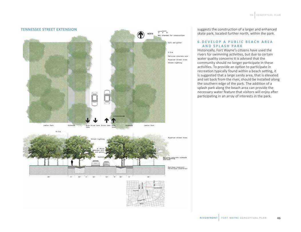
04 CONCEPTUAL PLAN
suggests the construction of a larger and enhanced skate park, located further north, within the park.
6 . D E V E L O P A P U B L I C B E A C H A R E A A N D S P L A S H P A R KHistorically, Fort Wayne’s citizens have used the rivers for swimming activities, but due to certain water quality concerns it is advised that the community should no longer participate in these activities. To provide an option to participate in recreation typically found within a beach setting, it is suggested that a large sandy area, that is elevated and set back from the river, should be installed along the southern edge of the park. The addition of a splash park along the beach area can provide the necessary water feature that visitors will enjoy after participating in an array of interests in the park.
TENNESSEE STREET EXTENSION
R i v e R f R o n t f o r t way n e C O N C E P T UA L P L A N 46

04 CONCEPTUAL PLAN
ADVENTURE PLAYGROUND LAWTON BEACH IN WINTER
PORCH SWING GROVE
LAWTON BEACH IN SUMMER
ZIP-LININg COURSE
SCIENCE CENTRAL PLAzA
LAwTON PARK ACTIVITIES
R i v e R f R o n t f o r t way n e C O N C E P T UA L P L A N47

04 CONCEPTUAL PLAN
TRAIL CORRIDOR
SCIENCE CENTRAL
ADVENTURE PLAYGROUND
SPY RUN CREEK
SCIENCE CENTRAL PLAzA
CHALLENGE COURSE
SKATE PARK / BMX BOWL
zIP LINES
CLIMBING WALLS
PARKING
AMUSEMENT ATTRACTIONS
URBAN FOOD GARDEN
CAFE / BATH HOUSE / MEETING SPACE
PASSIVE PARK
RECREATION TRAIL / BIKE PATH
TERRACED GARDENS
PEDESTRIAN PROMENADE
BOAT DOCK
FORT WAYNE BEACH
PEDESTRIAN BRIDGES
RIVER LIGHT SCULPTURE
1
1
2
2
7
7
11
11
10
10
10
9
9
2020
21
21
20
20
20
20
20
19
19
1515
15
16
16
17
17
18
18
12
12
13
13
14
14
14
8
8
3
3
4
4
5
5
6
6
Spy
Run
Ave
Clin
ton
Stre
et
Tennessee Street
Fourth Street
LAwTON ADVENTURE PARK
R i v e R f R o n t f o r t way n e C O N C E P T UA L P L A N 48

04 CONCEPTUAL PLAN
S P H E R E O F C O N F L U E N C E A N D T H E O L D F O R T The confluence of the St. Marys and St. Joseph Rivers forms a striking place of nature in the heart of the city. The confluence is dominated by mature trees and water, with views of the historic architecture of the Water Filtration Plant and of downtown from the Columbia Street Bridge. The waters of the two rivers are often different colors as they carry different sediment loads. Land areas shift from time to time as waters rise and fall and a rich riparian thicket has grown up along the banks of the rivers.
The design proposal for the confluence focuses on an environmental art installation. A ring of pedestrian bridges connect the three rivers while a field of blue-green lights fills the riparian spaces within the ring of bridges. The color highlights the rich verdant vegetation of the confluence. Cantilevered deck extensions are proposed for the Columbia Street Bridge to create pedestrian spaces for sitting and socializing, while the residents take in the view and the evening air. At dusk each evening the lights slowly brighten and dim.
Adjacent to the confluence is the Old Fort which is located on the north side of the St. Marys River, within the floodplain but behind the levee. The facility does not have a parking lot but can be accessed from Headwaters Park via a small pedestrian bridge, which is not ADA compliant. It can also be accessed from Lawton Park via the Rivergreenway and a pedestrian bridge over Spy Run Creek. The Old Fort was built in 1976 to commemorate the nation’s bicentennial. It serves as a living history attraction where visitors are taken back in time as they watch re-enactments of the daily life of soldiers and their families. Currently, a group of volunteers operate the Old Fort, holding re-enactments several times a year. This group, along with the Fort Wayne Parks Department, maintains the property.
R i v e R f R o n t f o r t way n e C O N C E P T UA L P L A N49

04 CONCEPTUAL PLAN
R E C O M M E N D A T I O N S 1 . E N H A N C E T H E C O L U M B I A S T R E E T B R I D G EThe Columbia Street Bridge should be enhanced to include a safe pedestrian crossing and spaces for sitting and socializing. These additions should enhance the bridge and may include garden terraces with seating, so that visitors can enjoy the natural scenery around the confluence.
2 . D E V E L O P L I G H T E D P E D E S T R I A N B R I D G E S Three pedestrian bridges are suggested around the confluence to create a “sphere” design that connects the downtown, the Water Filtration Plant and adjoining neighborhoods. The installation of these bridges should be completed with a lighting design that provides a nightly art event that invites residents to come to the river. The bridges themselves will highlight this special place during the day when lighting features are turned off.
3 . P L A N T I N G A L O N G T H E S T . j O S E P H L E V E E Carrying through the natural habitat spaces surrounding the confluence, it is suggested that existing planters within the rip-rap along the banks of the St. Joseph River should be re-planted with appropriate native species. These plantings will soften the landscape along the river and can provide benefits to wildlife. A maintenance arrangement would be needed to ensure care and watering of the plants until they are established.
4 . I N S T A L L A N E V E N T L A w N A T T H E O L D F O R T An event lawn should be considered south of the Old Fort. This dedicated event space can be rented for weddings and other special events. By adding new events and activities a revenue stream can be generated by the facility.
5 . E X P A N D T H E O L D F O R T T O I N C L U D E A D D I T I O N A L O U T B U I L D I N G SIt is suggested to construct additional buildings on the property of the Old Fort property that can provide additional programming space to allow a richer historical story to be told. This expansion of programming can increase interest in the fort and attract additional visitors and revenue.
6 . A C C E S S T O T H E O L D F O R TProviding better access to the Old Fort will be essential to creating new spaces and programs within the fort. A new ADA accessible pedestrian bridge that connects with Headwaters Park will allow visitors to move through and enjoy both spaces with ease. Enhancements along the Samuel Bigger Bridge are suggested and will provide safer access for pedestrians who want to visit the fort from downtown. The addition of a parking lot within close proximity of the Old Fort should also be considered as visitor attendance increases.
COLUMBIA STREET GARDEN BRIDGE DURING A NIGHT FESTIVAL
SPHERE OF CONFLUENCE CONCEPT LIGHTING PLAN
CANOE BOAT LAUNCH AT THE OLD FORT
R i v e R f R o n t f o r t way n e C O N C E P T UA L P L A N 50

04 CONCEPTUAL PLAN
1
2
3
4
5
NEW PEDESTRIAN BRIDGES
COLUMBIA STREET BRIDGE GARDEN TERRACES
GREENWAY TRAILS AND RIVER EDGE ENHANCEMENTS
“SPHERE OF CONFLUENCE” LIGHT SCULPTURE
NEW PLANTING ON ROCK BANK
SPHERE OF CONFLUENCE
123
45
R i v e R f R o n t f o r t way n e C O N C E P T UA L P L A N51

04 CONCEPTUAL PLAN
1
1
2
2
7
7
3
3
4
4
5
5
6
6
OLD FORT - ExISTINg
FORT ExTENSION - NEW BUILDINgS
NEW PARKING LOT
CANOE BOAT LAUNCH
EVENT LAWN
NEW PEDESTRIAN BRIDGE
SAMUEL BIGGER BRIDGE ENHANCEMENTS
THE OLD FORT
R i v e R f R o n t f o r t way n e C O N C E P T UA L P L A N 52

05 NEXT STEPS In order to make the visions within this plan a reality, the City of Fort Wayne will work to build a roadmap for the implementation of the Conceptual Plan. Initially, the City will serve as an interface between public and private entities. Partners should include owners, developers, institutions, non-profits, community groups and citizens. Public and private partnerships will be essential to bringing the Conceptual Plan to fruition.
The Riverfront Fort Wayne Conceptual Plan provides a long range vision for directing development now and for many years into the future. It represents both the current needs of the community and future aspirations. The document should serve as a set of shared values providing a common framework for future development. Immediate attention will be given to three primary functional areas – maintenance, programming and development.
• Maintenance Plan• Programming• Development• Resources • Preliminary Cost Estimates
The Riverfront Study Area is the focal point for future development around the downtown riverfront and therefore should be held to a higher level of construction and maintenance than other publicly-owned properties. This increased scrutiny is vital to ensure this development is pristine and becomes the economic driver that is desired. The Riparian Management Plan for the riverfront will address the environmental aspects by providing baseline data on existing conditions, offering management strategies for invasive species, recommending specific treatment methods, identifying important viewsheds and suggesting implementation of appropriate clearing/pruning strategies and techniques. Additionally, the 2013-2017 Parks and Recreation Master Plan highlights the importance of tree removal and replacement in the riparian corridor. The existing Fort Wayne Parks Department Urban Forest Management Plan should be the definitive resource for future care of the trees. The public components of the promenade, trails, streetscape, and outdoor park resources could be maintained by the Parks Department as part of the existing maintenance program, however increased use of the areas will also mean increased trash and maintenance requirements. This higher level of maintenance requires a dedicated staff whose schedule and budget will need to be established as the area is improved.
N E A R T E R M P R O G R A M M I N G Programming for the promenade adds a dynamic quality to the space; seasonal experiences give new life to the space even for frequent visitors. Events like a hot chocolate festival, races, holiday lights, concerts, and performances invite visitors to the place even during off-peak times. The riverfront area could be a new scene for arts, culture, service
I N T R O D U C T I O N
O V E R V I E w
M A I N T E N A N C E P L A N
P R O G R A M M I N G
R i v e R f R o n t f o r t way n e C O N C E P T UA L P L A N53

05 NEXT STEPS
and learning; it can build community while creating a popular destination. These activities require little monetary investment and can be planned by various city entities. Additionally, residents should be encouraged to shape their own programming both on and around the rivers. A full-time programming coordinator for the downtown riverfront is recommended.
L O N G T E R M P R O G R A M M I N G Beyond day festivals and short-term events, long-term programming such as a community marketplace with a commercial kitchen, business incubators and weekly classes can add value to the riverfront area. A full-time programming coordinator for the downtown riverfront will become an essential resource to ensure that programming within the area remains a priority. Long-term programming will continue to boost economic opportunities downtown.
The Conceptual Plan is intended to be developed in multiple phases over several decades. The phases include the promenade, Superior Street, Lawton Park, Bloomindale/guldlin Parks, the Confluence, and the Old Fort area. Phase 1 of the promenade is detailed in the next chapter. Later phases will likely be determined by the results of feasibility studies, available resources and private sector interests. R I V E R F R O N T D E V E L O P M E N T G O A L S Specific riverfront development goals have been established to ensure that the implementation of riverfront study priorities meet the vision anticipated by the community. • Provide areas intended for higher density mixed-use development oriented toward the rivers and planned riverfront promenade areas.
• Encourage the creation of places for people of all ages to live, socialize and recreate on and along the rivers in the downtown and near-downtown areas.
• Reintroduce natural and passive recreation areas oriented toward the rivers to allow residents to experience nature and river ecology.
• Encourage green infrastructure and other innovative stormwater management solutions which will filter and reduce the amount of stormwater entering the rivers from existing and new development.
• Provide connected multi-modal access within the riverfront area and to the downtown and adjacent neighborhoods.
• Protect designated river viewshed areas and enhance river area street corridors through streetscape design and building setbacks, massing, and height standards. • Encourage the establishment of centralized parking structures to serve multiple uses and on-street parking in developed areas in order to reduce the need for individual surface parking lots.
• Ensure that new development is built in accordance with Federal, State and local floodplain standards.
• Support and enhance the downtown riverfront as a safe and active people-oriented area connecting a series of distinct destinations in an urban setting of high-quality buildings and development.
The City has set aside funding to begin Phase 1 property acquisition and public-sector improvements and is working to leverage additional grant and private sector dollars. These planned improvements should entice private investment in the early
stages allowing public/private partnerships to emerge. Particular strategies could focus on the development of live-work incubator spaces, mixed use development and live-work-play environments. getting partners on board early will demonstrate market potential and encourage additional development to follow. Preliminary cost estimates have been developed for the conceptual Phase 1 vision, for the proposed Headwaters Junction project, and for Lawton Park improvements. Phase 1A on the south side of the St. Marys is estimated to cost approximately $13 million; across the river the Phase 1B is estimated to cost approximately $15 million. Headwaters Junction is estimated to cost $18 million and preliminary estimates for improvements at Lawton Park are close to $9 million. To develop the lake area envisioned on the St. Marys at Lawton Park would cost about $5 million.D E V E L O P M E N T
R E S O U R C E S
P R E L I M I N A R Y C O S T E S T I M A T E S
R i v e R f R o n t f o r t way n e C O N C E P T UA L P L A N 54

06 PHASE 1 The Riverfront Study Area includes approximately 2 ½ miles of river and 310 acres of land in the heart of the city. Because of its size, the project area has been divided into improvement areas to be addressed in phases. This chapter addresses both the public-sector improvements and the potential private-sector investments in Phase 1. During the planning process, it was determined that a Phase 1 project area should be identified and described in detail so that implementation of the Phase 1 could quickly follow the completion of the Conceptual Plan. Based on public preferences documented in the engagement process and comments received from the RAC, the area titled the Promenade was chosen as the best place to begin. This area, north and south of the St. Marys River, is envisioned as mixed-use development that includes a promenade with several raised platforms and terraces along the river and riverbanks. • Project Area• Land Uses• Development Stages• Economic Projections
The Phase 1 project area is centered around the Wells Street Bridge. This setting allows the project to take full advantage of the riverfront and allows residents and visitors to experience the river in a development type that currently does not exist in the Fort Wayne region. This area was identified for mixed-use development because of its proximity to downtown and walking connectivity north and south along Harrison Street and the Historic Wells Street Bridge. Additionally, the area has several underutilized properties and historical buildings and structures that could add authentic character to the project.
The image on the following page shows the proposed conceptual development around the Wells Street Bridge. Public-sector investments in the promenade and connected infrastructure will be near-term projects. Private-sector investment is appropriate where historic buildings could be reused as creative office, residential lofts, and retail shops wherever possible. Any new buildings should be designed to be in scale with historic buildings, but should use contemporary design forms and materials that are appropriate for this area of the city. Potential land uses and gFA (gross Floor Area) for the Phase 1 development are based on market demand projections prepared by the consultant team. The first stage of development is fairly modest and is focused on building demand through catalytic projects. It is primarily composed of a riverfront promenade, retail, restaurants, a hotel and small areas of residential and office. Later stages of development could build upon these successes and result in a growing mixed-use neighborhood
I N T R O D U C T I O N
O V E R V I E w
P R O j E C T A R E A
L A N D U S E S
R i v e R f R o n t f o r t way n e C O N C E P T UA L P L A N55

wELLS ST.
OLD wELLS ST. BRIDGE
HARRISON ST. BRIDGE
HEADwATERS PARK
SUPERIO
R ST.
06 PHASE 1
HEADwATERS jUNCTION
R i v e R f R o n t f o r t way n e C O N C E P T UA L P L A N 56
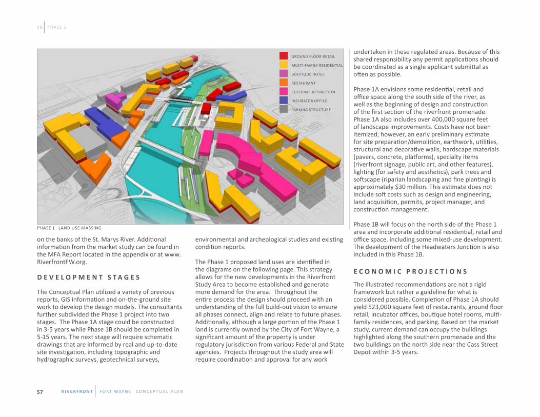
on the banks of the St. Marys River. Additional information from the market study can be found in the MFA Report located in the appendix or at www.RiverfrontFW.org.
The Conceptual Plan utilized a variety of previous reports, gIS information and on-the-ground site work to develop the design models. The consultants further subdivided the Phase 1 project into two stages. The Phase 1A stage could be constructed in 3-5 years while Phase 1B should be completed in 5-15 years. The next stage will require schematic drawings that are informed by real and up-to-date site investigation, including topographic and hydrographic surveys, geotechnical surveys,
environmental and archeological studies and existing condition reports. The Phase 1 proposed land uses are identified in the diagrams on the following page. This strategy allows for the new developments in the Riverfront Study Area to become established and generate more demand for the area. Throughout the entire process the design should proceed with an understanding of the full build-out vision to ensure all phases connect, align and relate to future phases. Additionally, although a large portion of the Phase 1 land is currently owned by the City of Fort Wayne, a significant amount of the property is under regulatory jurisdiction from various Federal and State agencies. Projects throughout the study area will require coordination and approval for any work
undertaken in these regulated areas. Because of this shared responsibility any permit applications should be coordinated as a single applicant submittal as often as possible.
Phase 1A envisions some residential, retail and office space along the south side of the river, as well as the beginning of design and construction of the first section of the riverfront promenade. Phase 1A also includes over 400,000 square feet of landscape improvements. Costs have not been itemized; however, an early preliminary estimate for site preparation/demolition, earthwork, utilities, structural and decorative walls, hardscape materials (pavers, concrete, platforms), specialty items (riverfront signage, public art, and other features), lighting (for safety and aesthetics), park trees and softscape (riparian landscaping and fine planting) is approximately $30 million. This estimate does not include soft costs such as design and engineering, land acquisition, permits, project manager, and construction management.
Phase 1B will focus on the north side of the Phase 1 area and incorporate additional residential, retail and office space, including some mixed-use development. The development of the Headwaters Junction is also included in this Phase 1B.
The illustrated recommendations are not a rigid framework but rather a guideline for what is considered possible. Completion of Phase 1A should yield 523,000 square feet of restaurants, ground floor retail, incubator offices, boutique hotel rooms, multi-family residences, and parking. Based on the market study, current demand can occupy the buildings highlighted along the southern promenade and the two buildings on the north side near the Cass Street Depot within 3-5 years.
GROUND FLOOR RETAIL
MULTI-FAMILY RESIDENTIAL
BOUTIqUE HOTEL
RESTAURANT
CULTURAL ATTRACTION
INCUBATOR OFFICE
PARKING STRUCTURE
PHASE 1 LAND USE MASSING
06 PHASE 1
D E V E L O P M E N T S T A G E SE C O N O M I C P R O j E C T I O N S
R i v e R f R o n t f o r t way n e C O N C E P T UA L P L A N57

Looking forward, Phase 1B adds 74,000 square feet for Headwaters Junction, along with another 886,000 square feet of uses. Phase 1B could take 5-15 years to complete depending on the strength of the market and the influence of the work along the river on the surrounding area. If the riverfront area proves popular another 56,000 square feet of retail beyond today’s projection is possible.
Illustrative sections have been developed at key locations along the riverfront to demonstrate the relationships between development, open spaces
and the river’s edge. These sections also indicate normal water level and 100 year flood elevations. These sections should continue to be refined as they are paired with the hydraulic model and reshaped to ensure that there is no upstream impact on flood elevations, and to ensure that proposed development parcels are clear of the flood way and flood plain. For additional information on the market potential of the riverfront area reference Market & Feasibility Advisors technical memo within the appendix.
NEW DEVELOPMENT
RE-DEvELOPMENT / ADAPTIvE RE-USE
High Street
Fairmount Street
Third Street
Superior Street
Hotel
Parking
Parking
Parking
Retail
Retail
Restauran
t
Residential
Offi
ce
Harrison Street
Calhoun StreetWel
ls St
reet
NEW DEVELOPMENT
NEW DEVELOPMENT
RE-DEvELOPMENT
High Street
Fairmount Street
Third Street
Hotel
Parking
Parking
Parking
ParkingParking
ParkingM
ixed Use
Mixed U
se
Mixed U
se
Surface Parking
Surface ParkingMixed U
se
Mixed U
seM
ixed Use
Mixed Use
MixedMixed
Mixed
Mixed
Retail
Restauran
t
Restaurant
Restauran
t
Restau-
rant
Restau-
rant
Residential
Cultu
ral
Cultural
Offi
ce
Office
Retail
Retail
RetailSuperior Street
Harrison Street
Calhoun Street
Wel
ls St
reet
06 PHASE 1
PHASE 1A PHASE 1B
R i v e R f R o n t f o r t way n e C O N C E P T UA L P L A N 58

P R O M E N A D E S O U T H S I D E The south side of the St. Marys River features lounge decks and plazas with a variety of places for shopping, dining and entertainment. This promenade side is an active waterfront edge with different offerings for the summer, winter, or nighttime, and filled with music and entertainment.
1
1
2
2
11
11
10109
9
12
12
13
13
15
15 16
16
17
17
7
7
14
14
8
83
3
4
4
5
56
6
Superior Street
Harrison Street
Wel
ls St
reet
RAIL SPUR TO HEADWATERS JUNCTION
PEDESTRIAN PATH
RIVERFRONT PARK
RECREATION TRAIL / BIKE PATH
RESTAURANTS / RETAIL SPACE
WELLS STREET PEDESTRIAN PATHWAY
FORT WAYNE OUTFITTERS
FLOATING STEP DECK AND BOAT DOCK
WATERFRONT PROMENADE
ADAPTIvE RE-USE DEvELOPMENT
RIVERSIDE PLAzA
BOUTIqUE HOTEL
PARKING STRUCTURES
RESTAURANT / RETAIL SPACE
CANTILEVERED DECK STRUCTURE
ROOFTOP DINING TERRACE
MIXED USE DEVELOPMENT
06 PHASE 1
17
17
17
R i v e R f R o n t f o r t way n e C O N C E P T UA L P L A N59

H E A D w A T E R S j U N C T I O N / P R O M E N A D E N O R T H S I D E
The north side of the St. Marys River offers a soft landscape with trails and rest zones, but it also hosts a variety of exciting programs. Headwaters Junction is a place to observe, celebrate, and experience Fort Wayne’s history with the historic locomotive No. 765. The north side is also marked by a floating stepped deck integrated with landscape, trails and a gathering spot with access to the river for canoeing, kayaking or touring.
1
1
2
2
7
7
11
111010
99
12
121313
8
8
3
3
4
4
5
5
6
6
High Street
Third Street
MIXED USE DEVELOPMENT
MULTI-FAMILY RESIDENTIAL
HEADWATERS JUNCTION
PEDESTRIAN BRIDGE
RESTAURANT / RETAIL SPACE
FOATING STEP DECK AND BOAT DOCK
WATERFRONT PROMENADE
HARRISON BRIDGE PLAzA
RECREATIONAL TRAIL / BIKE PATH
PEDESTRIAN PATH
ENTERTAINMENT DECK OVER WATER
FORT WAYNE OUTFITTERS
EXISTING POLICE AND FIRE MEMORIAL
1
06 PHASE 1
R i v e R f R o n t f o r t way n e C O N C E P T UA L P L A N 60

P R O M E N A D E S O U T H S I D E - L O O K I N G W E S TEvening illuminations, fountains, performance spaces and overlooks set a vibrant riverfront scene complete with dining, music and celebration. Whether it is for a special occasion or a night out, the riverfront should offer something for residents and visitors. The riverfront should be a catalyst for improving the urban character of downtown Fort Wayne by embracing the rivers
as an integral part of the urban landscape and creating a design that is beautiful, appropriate and clever enough to be compelling and lasting.
06 PHASE 1
R i v e R f R o n t f o r t way n e C O N C E P T UA L P L A N61

06 PHASE 1
P R O M E N A D E S O U T H S I D E - L O O K I N G E A S T
The Conceptual Plan seeks to create opportunities for public and private investment along the Riverfront Study Area. Connections across the river reinforce the idea of a winding district looping from south to north. Whether dining, shopping or strolling, the public could enjoy multi-level decks and platforms along a variety of river edge conditions. These public spaces and shopping destinations should result in new living
and working options and create an iconic regional destination for northern Indiana. The historic Wells Street Bridge is a central feature in the Riverfront Study Area. From wedding photos to yoga classes, the bridge already serves as a community landmark and gathering spot. The bridge could become even more of a historical centerpiece to this new community along the St. Marys River.
R i v e R f R o n t f o r t way n e C O N C E P T UA L P L A N 62

06 PHASE 1
P R O M E N A D E S O U T H S I D E - L O O K I N G E A S T
Seasonal heating elements, sculpture and pop-up stands could introduce warmth and merriment to Indiana’s cold months. An annual hot chocolate festival, as well as other programmed activities, should supplement shopping, dining and entertainment for year round use. A melding of art, landscape, engineering and urban design should
create layers of interest, and offer a rich interplay between natural systems and urban spaces.
R i v e R f R o n t f o r t way n e C O N C E P T UA L P L A N63

06 PHASE 1
P R O M E N A D E N O R T H S I D E - L O O K I N G E A S T
Landscaped berms seeded with meadow grasses and wildflowers native to northern Indiana could soften the connection to the river’s edge. Iconic design elements mixed with riparian vegetation should help bolster native habitat of the region. From the deck, visitors can access the river to spend the day boating, bird watching, fishing
or just relaxing. The Conceptual Plan calls for connected networks by orchestrating a mix of urban areas and open spaces. Existing and future habitat corridors along the rivers make ecology an integral piece to the identity of the Riverfront Study Area. Nearby, Headwaters Junction should draw regional and national visitors who could spend the day or a long weekend in Fort Wayne.
R i v e R f R o n t f o r t way n e C O N C E P T UA L P L A N 64
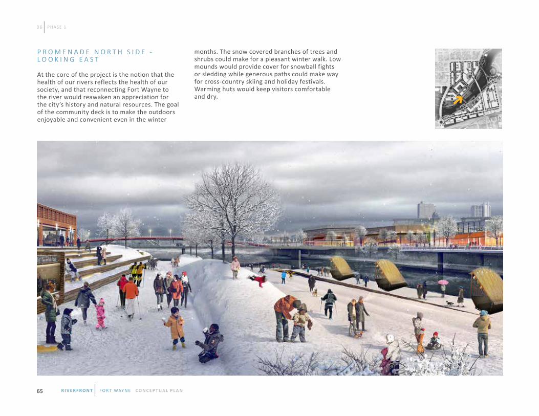
06 PHASE 1
P R O M E N A D E N O R T H S I D E - L O O K I N G E A S T
At the core of the project is the notion that the health of our rivers reflects the health of our society, and that reconnecting Fort Wayne to the river would reawaken an appreciation for the city’s history and natural resources. The goal of the community deck is to make the outdoors enjoyable and convenient even in the winter
months. The snow covered branches of trees and shrubs could make for a pleasant winter walk. Low mounds would provide cover for snowball fights or sledding while generous paths could make way for cross-country skiing and holiday festivals. Warming huts would keep visitors comfortable and dry.
R i v e R f R o n t f o r t way n e C O N C E P T UA L P L A N65

B
A
06 PHASE 1
100 year flood line +758.0
average water line +746.0
step
ped
dec
k
scu
lpte
d l
and
form
recr
eati
on
tra
il
scu
lpte
d l
and
form
pro
pose
d b
uil
din
g l
ine
mai
n p
rom
enad
e
view
ing
ste
ps
PROMENADE - NORTHSIDE SECTION ‘A’
flo
atin
g r
iver
dec
k
rive
r’s
edg
e
fixe
d r
iver
dec
k
scu
lpte
d l
and
form
recr
eati
on
tra
il
view
ing
ste
ps
mai
n p
rom
enad
e
pro
pose
d b
uil
din
g l
ine
100 year flood line +758.0
average water line +746.0
PROMENADE - NORTHSIDE SECTION ‘B’
P R O M E N A D E S E C T I O N D I A G R A M S
R i v e R f R o n t f o r t way n e C O N C E P T UA L P L A N 66
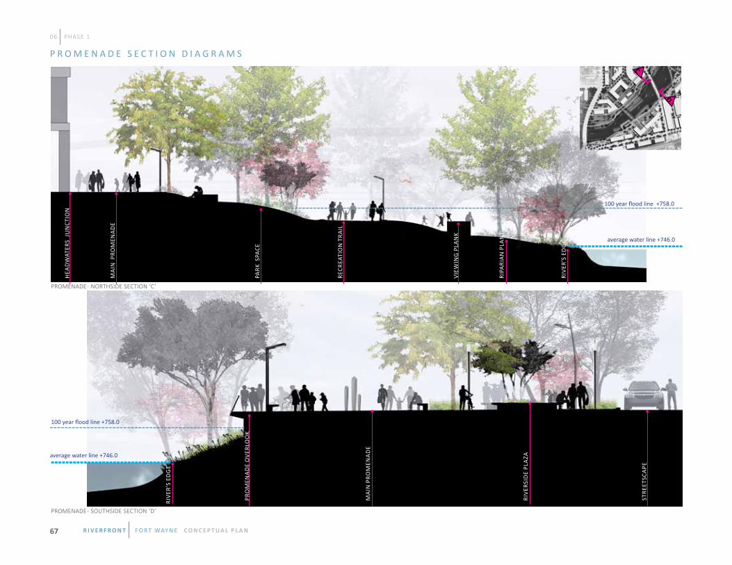
DC
06 PHASE 1
hea
dw
ater
s ju
nct
ion
mai
n p
rom
enad
e
recr
eati
on
tra
il
park
spa
ce
view
ing
pla
nk
ripa
rian
pla
nt.
rive
r’s
edg
e
100 year flood line +758.0
average water line +746.0
PROMENADE - NORTHSIDE SECTION ‘C’
stre
etsc
ape
rive
rsid
e pl
aza
mai
n p
rom
enad
e
pro
men
ade
ove
rlo
ok
rive
r’s
edg
e
100 year flood line +758.0
average water line +746.0
PROMENADE - SOUTHSIDE SECTION ‘D’
P R O M E N A D E S E C T I O N D I A G R A M S
R i v e R f R o n t f o r t way n e C O N C E P T UA L P L A N67

F
E
06 PHASE 1
mai
n p
rom
enad
e
pro
pose
d b
uil
din
g l
ine
low
er p
rom
enad
e
elev
ated
riv
er d
eck
100 year flood line +758.0
average water line +746.0
PROMENADE - SOUTHSIDE SECTION ‘E’
mai
n p
rom
enad
e
pro
pose
d b
uil
din
g l
ine
ove
rlo
ok
riv
er d
eck
elev
ated
riv
er d
eck
100 year flood line +758.0
average water line +746.0
PROMENADE - SOUTHSIDE SECTION ‘F’
P R O M E N A D E S E C T I O N D I A G R A M S
R i v e R f R o n t f o r t way n e C O N C E P T UA L P L A N 68

pro
pose
d b
uil
din
g l
ine
mai
n p
rom
enad
e
mis
t f
ou
nta
in
pro
men
ade
ove
rlo
ok
elev
ated
riv
er d
eck
mai
n p
rom
enad
e
pro
pose
d b
uil
din
g l
ine
pro
men
ade
ove
rlo
ok
PROMENADE - SOUTHSIDE SECTION ‘G’
PROMENADE - SOUTHSIDE SECTION ‘H’
100 year flood line +758.0
100 year flood line +758.0
average water line +746.0
average water line +746.0
06 PHASE 1
GH
elev
ated
riv
er d
inin
g d
eck
P R O M E N A D E S E C T I O N D I A G R A M S
R i v e R f R o n t f o r t way n e C O N C E P T UA L P L A N69

R i v e R f R o n t f o r t way n e C O N C E P T UA L P L A N 70

C I T Y O F F O R T w A Y N E C O P Y R I G H T © 2 0 1 5