Embed Size (px)
Citation preview
1
Conceptual modelling of seafaring, climate and the early European exploration and settlement of the North Atlantic Islands Andrew J. Dugmore, Institute of Geography, School of GeoSciences, University of Edinburgh, Drummond Street, Edinburgh EH8 9XP, UK [email protected] Andrew F. Casely, Institute of Geography, School of GeoSciences, University of Edinburgh, Drummond Street, Edinburgh EH8 9XP, UK [email protected] Christian Keller, IKOS, University of Oslo, P.O.Box 1010 Blindern, 0315 Oslo, NORWAY [email protected] Thomas H. McGovern, Hunter Bioarchaeology Laboratory, Department of Anthropology, Hunter College, City University of New York, 695 Park Ave, New York City 10021, USA [email protected] ABSTRACT This paper proposes a conceptual model for seafaring that integrates human and natural factors and expresses seafaring possibilities for specific islands within the North Atlantic region and the region as a whole in terms of 3-D spaces defined by a combination of motivation, environment and marine technology. Limits differ for different groups of people, different locations and different types of climate. To illustrate the conceptual model we consider three contrasting periods within the early European exploration and settlement of the North Atlantic islands; the very limited pre Viking Age settlement of the Faroe Islands, the end of the Icelandic ‘Settlement Period’ and the initial Norse settlement of Greenland.
2
Introduction This paper outlines a new conceptual model of seafaring. As seafaring may be considered to be travelling by sea together with the related technology, skills and motivation for so doing, it encompasses many different types of activity ranging from the explorer, to the hunter and colonist, raider and trader (Little et al. 1966, Marcus, 1980). A key aspect of seafaring is the pattern of settlement related to it; where people may live either temporarily or permanently as a consequence of seafaring, how settlements change through time. It also affects areas that might be utilised, activities that might be undertaken, and the contacts and communication that may result from the use of water as connection rather than barrier. When considering seafaring and its results (such as the human colonisation of oceanic islands) there is a risk of reaching inappropriate, monocausal explanations. The extent and nature of island settlement is affected by the availability of marine technology, but this is rarely, if ever, the only explanation. Likewise, favourable and unfavourable winds and ocean conditions will have an important role in creating opportunities or constraints, but again they are most unlikely to offer a complete explanation of seafaring activity or its results as their impact is moderated or enhanced by other factors such as available technology. The same argument also applies to motivation and the related human factors such as people’s knowledge of the sea, their skills, willingness to embrace risk and desire to explore. These human aspects are critical to seafaring, but they cannot be wholly separated from available technology and the natural environment. As a result our aim is to devise a robust conceptual framework that integrates human and environmental factors and is relevant to many different seafaring activities and the geographical ranges over which they take place. The idea is to define for specific areas the various combinations of marine technology, motivation and knowledge, and climate and ocean conditions that result in successful seafaring. One benefit of this approach is that it defines different types of limits, and may include many different approaches to successful seafaring. What might, for example, be achieved in the face of climate change by low levels of marine technology combined with very high motivation compared to lesser motivations, but more capable technology? A new conceptual model of seafaring Our conceptual model is based on the notion that four key aspects of seafaring are location, motivation, environmental conditions, and marine technology. Although there are circumstances when one of these factors dominates seafaring, our assumption is that in most situations interplay of all is relevant and that many different interactions may be occurring at any one time and collectively affecting the extent, nature and intensity of seafaring.
3
Considering these four aspects in turn: ‘Locations’ are the land areas connected by seafaring. These are areas where evidence of seafaring may be found as physical remains, such as boats, marine products, trade goods from overseas, or indeed, in the case of islands, simply the presence of people. Places may be connected to seafaring in a less tangible, but very real way by written sources, legends and myths. ‘Seafaring motivation’ is perhaps one of the hardest elements to quantify, especially for the more remote past. Motivations may be inferred, although this inference may be little better than informed guesswork. We can suggest that crucial differences did occur between groups such as explorers, hunters, colonists and traders, in terms of motivation, knowledge and skills. ‘’Environmental conditions’ may be known in some detail from proxy environmental records, but they may also be rather uncertain and their relationship to seafarers’ motivation difficult to describe and their potential effects on seafaring hard to directly document. ‘Marine technology’ can leave behind a tangible record, but this record variably degrades through time, and before modern times may be quite fragmentary, even if it is known at all (McGrail, 1998). Furthermore, even when known in detail the physical remains of past marine technology may be open to significantly different interpretations of their maritime effectiveness, dependent on the rather less well known aspects of related maritime knowledge and motivations (e.g. Keller and Christensen 2000). Despite these inherent limitations of our proxy evidence for past maritime activity, in some cases it may be reasonable to combine what evidence we have with some bridging models which may offer a fresh perspective on longstanding debates and may allow us to more explicitly explore the factors leading to successful or unsuccessful seafaring. Such models also tend to flag up areas needing additional research and force explicit consideration of potentially interacting variables. Motivation, environmental conditions and marine technology may be combined in a conceptual model using three dimensions defined by x, y and z axes, and used to describe seafaring possibilities and limits in relation to location. The axes may use qualitative or quantitative measures to describe the relevant variables. Figure 1 illustrates this by showing the possible accessibility of the Shetland Islands from the British mainland. The 3-D space to the right and in front of the solid surface represents the combinations of factors that lead to successful voyages; the surface defines probable limits to success. For illustration three sets of changing relationship are highlighted on the main figure and also show as inset graphs. Line 1 illustrates how for a given level of technology the motivation required for a successful voyage increases as environmental conditions become less favourable. Line 2 illustrates how for any given set of environmental conditions, the motivation for successful voyaging to Shetland will have to be greater with lower levels of marine technology. Line 3 indicates that if motivation remains unchanged, less favourable weather conditions require better marine technology (more seaworthy boats) to achieve the same results. In each case the white area on the graph represents ‘successful’ seafaring outcomes and the shaded area seafaring ‘failure’.
4
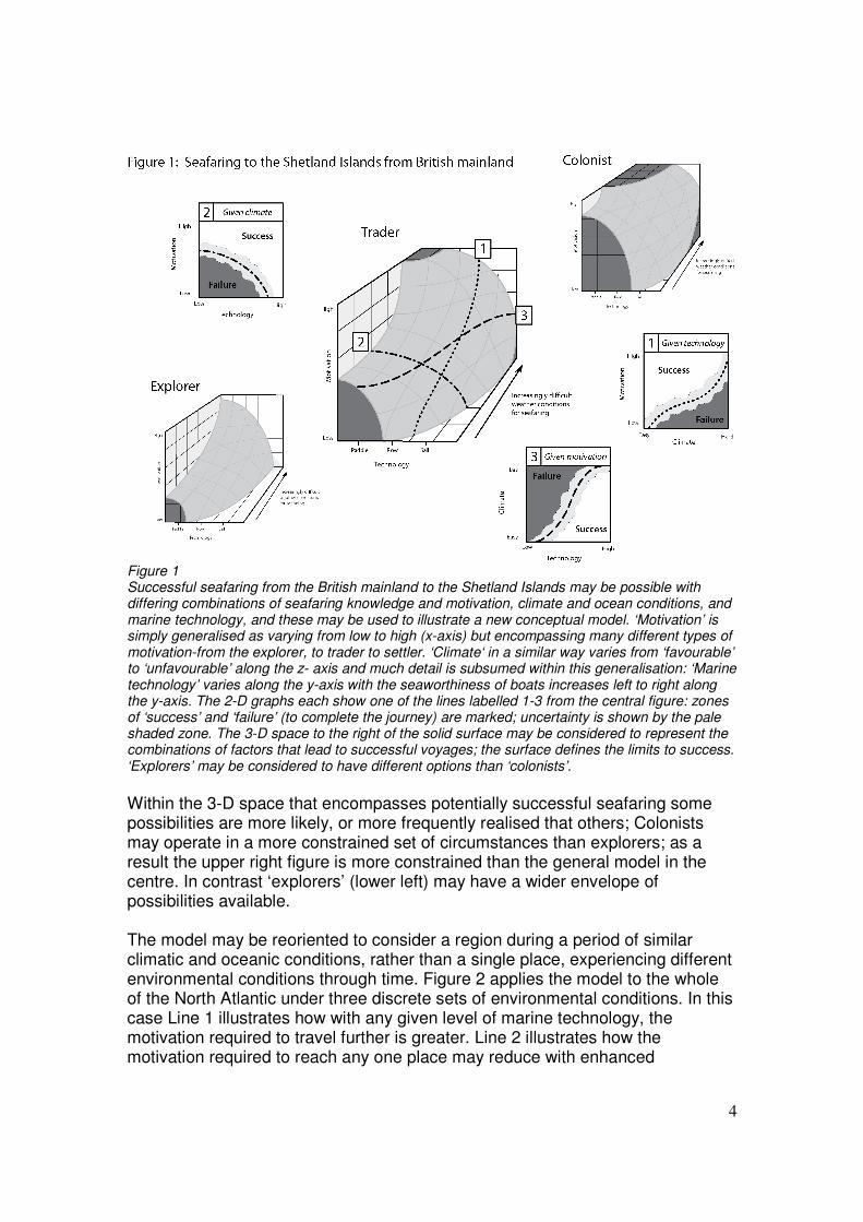
Figure 1 Successful seafaring from the British mainland to the Shetland Islands may be possible with differing combinations of seafaring knowledge and motivation, climate and ocean conditions, and marine technology, and these may be used to illustrate a new conceptual model. ‘Motivation’ is simply generalised as varying from low to high (x-axis) but encompassing many different types of motivation-from the explorer, to trader to settler. ‘Climate‘ in a similar way varies from ‘favourable’ to ‘unfavourable’ along the z- axis and much detail is subsumed within this generalisation: ‘Marine technology’ varies along the y-axis with the seaworthiness of boats increases left to right along the y-axis. The 2-D graphs each show one of the lines labelled 1-3 from the central figure: zones of ‘success’ and ‘failure’ (to complete the journey) are marked; uncertainty is shown by the pale shaded zone. The 3-D space to the right of the solid surface may be considered to represent the combinations of factors that lead to successful voyages; the surface defines the limits to success. ‘Explorers’ may be considered to have different options than ‘colonists’. Within the 3-D space that encompasses potentially successful seafaring some possibilities are more likely, or more frequently realised that others; Colonists may operate in a more constrained set of circumstances than explorers; as a result the upper right figure is more constrained than the general model in the centre. In contrast ‘explorers’ (lower left) may have a wider envelope of possibilities available. The model may be reoriented to consider a region during a period of similar climatic and oceanic conditions, rather than a single place, experiencing different environmental conditions through time. Figure 2 applies the model to the whole of the North Atlantic under three discrete sets of environmental conditions. In this case Line 1 illustrates how with any given level of marine technology, the motivation required to travel further is greater. Line 2 illustrates how the motivation required to reach any one place may reduce with enhanced
5
technology, and conversely, Line 3 indicates that if motivation remains unchanged, better marine technology (e.g. more seaworthy boats) is required to successfully venture further across the Atlantic. The upper figure illustrates how the impact of less favourable weather and ocean conditions could reduce the possibilities for success, and the lower figures shows how success may be enhanced by more benign conditions.
Seafaring and settlement A range of different seafaring possibilities can be identified related to the process of European settlement the North Atlantic off shore islands. The Faroes, Iceland and Greenland were first colonized by humans between approximately the 7h and 11th centuries AD . The best documented colonisers of this period were Scandinavians, and their ultimately trans-Atlantic voyages certainly reflect improvements in boat building and seafaring skills prior to and during the Viking Age. Orri Vésteinsson has proposed a model of the process of island settlement, conceiving it as a progression through discovery, exploration and knowledge acquisition, preparation and ephemeral settlement, to long-term success (Vésteinsson et al. 2005). Formally this has been stated by Vésteinsson (Vésteinsson et al. 2005) as:
6
1. Discovery (often unplanned) 2. Exploration (both organized knowledge-seeking expeditions and as a by product of hunting or other pursuits) 3. Preparation for long term settlement (initially stock release, or small scale attempts at colonization) 4. Planned (successful and long term) settlement. By considering seafaring at different stages of the European settlement of the North Atlantic Islands, as they played out in different ways in changing human and physical environments, and in a context of changing ship types and ocean navigation skills, we can provide a robust test of our model.
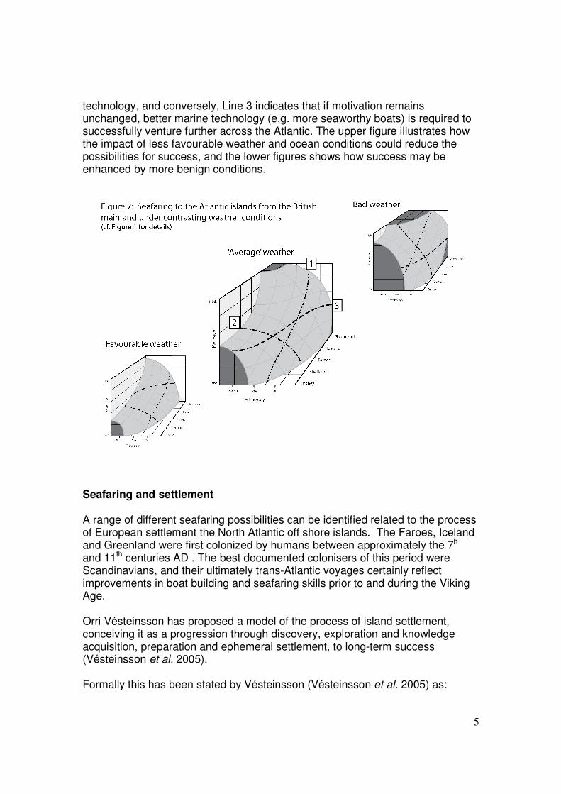
Figure 3 North Atlantic seafaring in the Viking Age: Journeys of different distance across the ocean are possible with very different combinations of motivation, environmental conditions and marine technology. The European colonisations of the Faroes, Iceland and Greenland are primarily a sequence of Viking Age events, involving some of the many different boats utilised by the Scandinavians of these times (Crumlin-Pedersen, 1991; 1997; Christensen, 1992:20; 2002:66). The sail was apparently introduced in Nordic ship-building around AD 700. During the 9th century an ocean-going ‘all-purpose’ sailing vessel was developed as demonstrated by the Tune and Oseberg ship finds, While further diversification of ship-types took place during the 10th and 11th centuries, now increasingly well documented by a growing number of excavated wrecks, burials, and deliberately sunken vessels (Crumlin
7
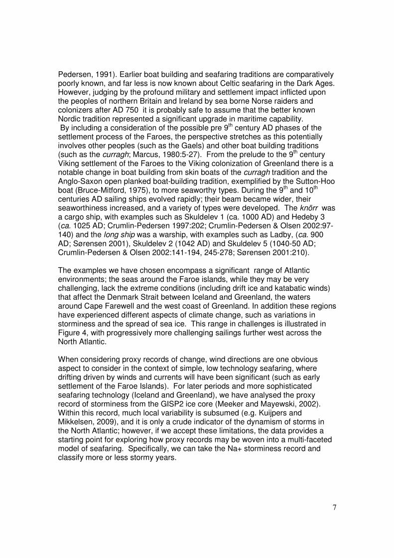
Pedersen, 1991). Earlier boat building and seafaring traditions are comparatively poorly known, and far less is now known about Celtic seafaring in the Dark Ages. However, judging by the profound military and settlement impact inflicted upon the peoples of northern Britain and Ireland by sea borne Norse raiders and colonizers after AD 750 it is probably safe to assume that the better known Nordic tradition represented a significant upgrade in maritime capability. By including a consideration of the possible pre 9th century AD phases of the settlement process of the Faroes, the perspective stretches as this potentially involves other peoples (such as the Gaels) and other boat building traditions (such as the curragh; Marcus, 1980:5-27). From the prelude to the 9th century Viking settlement of the Faroes to the Viking colonization of Greenland there is a notable change in boat building from skin boats of the curragh tradition and the Anglo-Saxon open planked boat-building tradition, exemplified by the Sutton-Hoo boat (Bruce-Mitford, 1975), to more seaworthy types. During the 9th and 10th centuries AD sailing ships evolved rapidly; their beam became wider, their seaworthiness increased, and a variety of types were developed. The knörr was a cargo ship, with examples such as Skuldelev 1 (ca. 1000 AD) and Hedeby 3 (ca. 1025 AD; Crumlin-Pedersen 1997:202; Crumlin-Pedersen & Olsen 2002:97-140) and the long ship was a warship, with examples such as Ladby, (ca. 900 AD; Sørensen 2001), Skuldelev 2 (1042 AD) and Skuldelev 5 (1040-50 AD; Crumlin-Pedersen & Olsen 2002:141-194, 245-278; Sørensen 2001:210). The examples we have chosen encompass a significant range of Atlantic environments; the seas around the Faroe islands, while they may be very challenging, lack the extreme conditions (including drift ice and katabatic winds) that affect the Denmark Strait between Iceland and Greenland, the waters around Cape Farewell and the west coast of Greenland. In addition these regions have experienced different aspects of climate change, such as variations in storminess and the spread of sea ice. This range in challenges is illustrated in Figure 4, with progressively more challenging sailings further west across the North Atlantic. When considering proxy records of change, wind directions are one obvious aspect to consider in the context of simple, low technology seafaring, where drifting driven by winds and currents will have been significant (such as early settlement of the Faroe Islands). For later periods and more sophisticated seafaring technology (Iceland and Greenland), we have analysed the proxy record of storminess from the GISP2 ice core (Meeker and Mayewski, 2002). Within this record, much local variability is subsumed (e.g. Kuijpers and Mikkelsen, 2009), and it is only a crude indicator of the dynamism of storms in the North Atlantic; however, if we accept these limitations, the data provides a starting point for exploring how proxy records may be woven into a multi-faceted model of seafaring. Specifically, we can take the Na+ storminess record and classify more or less stormy years.
8
Figure 4 Seafaring from the Western Islands: From the northern tip of the Isle of Lewis, the highest frequencies of wind directions blow towards the Faroe Islands (10 years of daily data from Stornoway; http://gis.ncdc.noaa.gov/). Wind drift and horizons are modelled using Casely’s PLACE spatial model (as in Casely, 2006; Casely and Dugmore, 2007). Modelled horizons are based on an observer altitude of 4m.a.s.l., incorporate correction for earth curvature, and do not take into account enhancing features such as cloud caps on mountains. The Faroe Islands are the most probable destination of drift passages from the Western Isles. Over the millennia when seafaring around the British coast had become routine, but when there was no apparent settlement of the Faroe Islands, the comparative closeness combined with the flow of both prevailing winds and ocean currents mean that ‘accidental’ discovery was possible, however, as the return journey is more problematic (cf Fig. 5) environmental conditions may be one of the factors contributing to the lack of prehistoric settlement. Motivations for seafaring during the early settlement periods of the Atlantic islands will also have varied, and may have been significantly affected by the skills of the seafarers, in particular their capability for reliable navigation out of sight of land, the other key component of seafaring in general and deep-ocean passages in particular. With the ocean-going ships came developments in navigation, from coastal navigation or pilotage, to ocean navigation. Coastal navigation uses land-based fix-points as references; in its more sophisticated form it is sufficient to navigate to the Orkneys, Shetland and the Faroes. Ocean navigation for crossings to Iceland and Greenland is mostly about latitude navigation, and this is primarily celestial, i.e. utilising the altitude of the sun at mid-day to indicate how far north you are). Navigation by stars though possible was more difficult; partially because of the lack of a bright ‘pole star’ which would provide a north point (Polaris was c. 7° from the north celestial pole in 800AD).
9
Effective celestial navigation means that a reasonably true course can be held east-west, but it is of little help when sailing north-south. Longitudinal navigation (i.e. finding the position on a meridian) demands some kind of time-keeping device, and was not properly developed until the invention of the chronometer by John Harrison in the mid 18th century AD. Medieval ocean route-finding mostly combined the techniques of coastal and latitude navigation. It must be assumed that such knowledge was partly a precondition for a systematic colonisation of Iceland in the late 9th to early 10th centuries AD, and partly that it was developed further as a consequence of that colonisation. The Faroes can be reached by coastal navigation from Britain, and by latitude navigation from south west Norway. Reasonably regular ocean traffic to Greenland would have demanded latitude navigation. In the model it is assumed that navigation skills will be a factor in boosting motivation. The influence of climate on seafaring, ‘accidental’ discovery, exploration and early settlement of the Faroe Islands It is possible that with only limited seafaring technology, prevailing winds and ocean currents influenced (or even determined) the limits to European settlement of the North Atlantic before the seafaring developments of the Viking Age. The traditional date for the Norse settlement (Landnám) of the Faroe islands is ca. 800 AD (Arge, 1991). In addition there is a long and popularly-held belief that Christian Gaels (Irish monks or papar), were even earlier settlers, reaching the islands a century or so earlier (Jones, 1964:10; Debes, 1993). There are the enigmatic ancient (or Irish, Celtic or Frisian) fields (Brandt and Guttesen, 1981; Dahl 1968), and written sources: Around 825 AD the Irish monk Dicuil wrote Liber de mensura orbis terrae (Tierney 1967) in which he stated:. “14. There are many other islands in the ocean to the north of Britain which can be reached from the northern islands of Britain in a direct voyage of two days and nights with sails filled with a favourable wind. A devout priest told me that in two summer days and the intervening night he sailed in a two-benched boat and entered one of them. 15. There is another set of small islands, nearly all separated by narrow stretches of water; in these for nearly a hundred years hermits sailing from our country Ireland have lived. But just as they were always deserted from the beginning of the world, so now because of the Northman pirates they are emptied of anchorites, and filled with countless sheep and very many diverse kinds of sea-birds. I have never found these islands mentioned in the authorities” It is likely that the latter islands are the Faroes. (Tierney, 1967; Thorsteinsson 2005:40-41; see also Arge 1991). In addition there are a growing number of pollen records indicating human activity from about the 7th century onwards (e.g. Hannon and Bradshaw 2000; Hannon et al., 2001; Edwards et al., 2005; Edwards and Borthwick, in press), but
10
Stummann Hansen (2003: 59) has noted that conclusive archaeological proof of a Celtic or pre-Viking presence is still lacking. This lack of archaeological evidence for Faroese settlement between the 7th and 9th centuries AD is significant, but not necessarily definitive; in the Western and Northern Islands of Scotland pollen evidence of Mesolithic settlement (Edwards, 1996) at first had no archaeological support, but now this evidence seems to have been found (Melton and Nicholson, 2004; Gregory et al., 2005). So there is the strong possibility that there was some human presence in the Faroe Islands before ca. 800 AD, but at present no definitive proof. Crucially any human presence in the century or so before landnám was, most probably, very limited in relation to later Norse settlement. The Faroe Islands lack the rich prehistoric archaeological record of the north western British Isles, and clearly also lacked prehistoric populations on the scale of the near by northern and western isles of Scotland. Although this is consistent with the early stages of Vésteinsson’s colonization model (Vésteinsson et al., 2005) it is uncertain if the lack of still earlier (prehistoric) settlement was simply due to a lack of knowledge of the islands, contemporary seafaring limitations, or factors more to do with the nature of past societies, such as their subsistence base and trading activities. A simple lack of knowledge of the Faroes is unlikely to be the complete explanation for a lack of prehistoric settlement. Marine drift dispersal (assuming minimal use of sails, paddles or oars) from the Western Isles of Scotland has a high probability of reaching the Faroe Islands because of the prevailing directions of oceanic and atmospheric circulation (Fig.4). Over the multi-century timescales of prehistoric seafaring along Atlantic coasts of NW Europe and between the British Isles it is probable that some mariners were swept or blown towards the Faroe Islands (Fig.4). The journey need not be long before the islands are in sight as the visual gap between the two island groups is much less than 150 km, and in clear or lightly clouded conditions cloud-caps forms above the islands at several thousand meters altitude. These “landskyer” or land-clouds indicate the presence of islands even when land itself is out of sight below the horizon. Although people may have been aware directly, or indirectly of the Faroe Islands long before the first known contacts during the 1st millennium AD, the frequency of winds and currents flowing in the direction of the Faroe Islands from the British Isles, the very environmental factors that help to put the islands potentially within reach, also make return journeys more difficult. Here though, a critical asymmetry may exist in relation to the return leg of accidental voyages from the Western isles to the Faroes: once our putative, storm-driven seafarers had landed in the Faroe Islands a degree of choice becomes available as they could wait for favourable winds before attempting a return journey (assuming they knew their approximate direction of travel). Return journeys are key to settlement in the
11
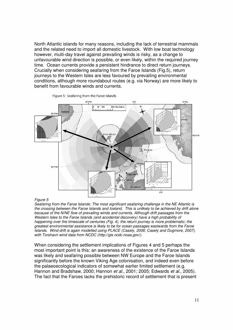
North Atlantic islands for many reasons, including the lack of terrestrial mammals and the related need to import all domestic livestock. With low boat technology however, multi-day travel against prevailing winds is risky, as a change to unfavourable wind direction is possible, or even likely, within the required journey time. Ocean currents provide a persistent hindrance to direct return journeys. Crucially when considering seafaring from the Faroe Islands (Fig.5), return journeys to the Western Isles are less favoured by prevailing environmental conditions, although more roundabout routes (e.g. via Norway) are more likely to benefit from favourable winds and currents.
Figure 5 Seafaring from the Faroe Islands: The most significant seafaring challenge in the NE Atlantic is the crossing between the Faroe Islands and Iceland. This is unlikely to be achieved by drift alone because of the N/NE flow of prevailing winds and currents. Although drift passages from the Western Isles to the Faroe Islands (and accidental discovery) have a high probability of happening over the timescale of centuries (Fig. 4), the return journey is more problematic; the greatest environmental assistance is likely to be for ocean passages eastwards from the Faroe Islands. Wind drift is again modelled using PLACE (Casely, 2006; Casely and Dugmore, 2007), with Torshavn wind data from NCDC (http://gis.ncdc.noaa.gov/). When considering the settlement implications of Figures 4 and 5 perhaps the most important point is this: an awareness of the existence of the Faroe Islands was likely and seafaring possible between NW Europe and the Faroe Islands significantly before the known Viking Age colonisation, and indeed even before the palaeoecological indicators of somewhat earlier limited settlement (e.g. Hannon and Bradshaw, 2000; Hannon et al., 2001; 2005; Edwards et al., 2005). The fact that the Faroes lacks the prehistoric record of settlement that is present
12
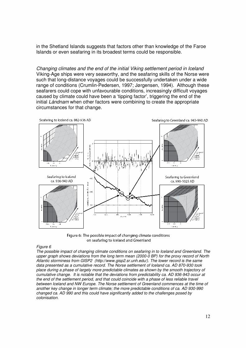
in the Shetland Islands suggests that factors other than knowledge of the Faroe Islands or even seafaring in its broadest terms could be responsible. Changing climates and the end of the initial Viking settlement period in Iceland Viking-Age ships were very seaworthy, and the seafaring skills of the Norse were such that long-distance voyages could be successfully undertaken under a wide range of conditions (Crumlin-Pedersen, 1997; Jørgensen, 1994). Although these seafarers could cope with unfavourable conditions, increasingly difficult voyages caused by climate could have been a ‘tipping factor’, triggering the end of the initial Lándnam when other factors were combining to create the appropriate circumstances for that change.
Figure 6 The possible impact of changing climate conditions on seafaring in to Iceland and Greenland. The upper graph shows deviations from the long term mean (2000-0 BP) for the proxy record of North Atlantic storminess from GISP2 (http://www.gisp2.sr.unh.edu/). The lower record is the same data presented as a cumulative record. The Norse settlement of Iceland ca. AD 870-930 took place during a phase of largely more predictable climates as shown by the smooth trajectory of cumulative change. It is notable that the deviations from predictability ca. AD 936-943 occur at the end of the settlement period, and that could coincide with a phase of less reliable travel between Iceland and NW Europe. The Norse settlement of Greenland commences at the time of another key change in longer term climate; the more predictable conditions of ca. AD 930-990 changed ca. AD 990 and this could have significantly added to the challenges posed by colonisation.
13
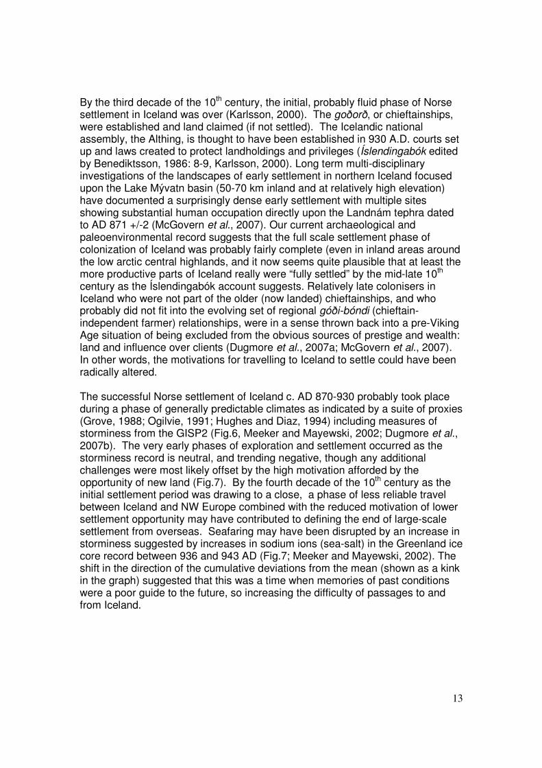
By the third decade of the 10th century, the initial, probably fluid phase of Norse settlement in Iceland was over (Karlsson, 2000). The goðorð, or chieftainships, were established and land claimed (if not settled). The Icelandic national assembly, the Althing, is thought to have been established in 930 A.D. courts set up and laws created to protect landholdings and privileges (Íslendingabók edited by Benediktsson, 1986: 8-9, Karlsson, 2000). Long term multi-disciplinary investigations of the landscapes of early settlement in northern Iceland focused upon the Lake Mývatn basin (50-70 km inland and at relatively high elevation) have documented a surprisingly dense early settlement with multiple sites showing substantial human occupation directly upon the Landnám tephra dated to AD 871 +/-2 (McGovern et al., 2007). Our current archaeological and paleoenvironmental record suggests that the full scale settlement phase of colonization of Iceland was probably fairly complete (even in inland areas around the low arctic central highlands, and it now seems quite plausible that at least the more productive parts of Iceland really were “fully settled” by the mid-late 10th century as the Íslendingabók account suggests. Relatively late colonisers in Iceland who were not part of the older (now landed) chieftainships, and who probably did not fit into the evolving set of regional góði-bóndi (chieftain-independent farmer) relationships, were in a sense thrown back into a pre-Viking Age situation of being excluded from the obvious sources of prestige and wealth: land and influence over clients (Dugmore et al., 2007a; McGovern et al., 2007). In other words, the motivations for travelling to Iceland to settle could have been radically altered. The successful Norse settlement of Iceland c. AD 870-930 probably took place during a phase of generally predictable climates as indicated by a suite of proxies (Grove, 1988; Ogilvie, 1991; Hughes and Diaz, 1994) including measures of storminess from the GISP2 (Fig.6, Meeker and Mayewski, 2002; Dugmore et al., 2007b). The very early phases of exploration and settlement occurred as the storminess record is neutral, and trending negative, though any additional challenges were most likely offset by the high motivation afforded by the opportunity of new land (Fig.7). By the fourth decade of the 10th century as the initial settlement period was drawing to a close, a phase of less reliable travel between Iceland and NW Europe combined with the reduced motivation of lower settlement opportunity may have contributed to defining the end of large-scale settlement from overseas. Seafaring may have been disrupted by an increase in storminess suggested by increases in sodium ions (sea-salt) in the Greenland ice core record between 936 and 943 AD (Fig.7; Meeker and Mayewski, 2002). The shift in the direction of the cumulative deviations from the mean (shown as a kink in the graph) suggested that this was a time when memories of past conditions were a poor guide to the future, so increasing the difficulty of passages to and from Iceland.
14
Figure 7 The GISP2 NA+ cumulative storminess record (see Fig.6) between 860 AD and 1030 AD (data from GISP2 project, http://www.gisp2.sr.unh.edu/). Data points have been evenly divided into � more stormy, � average and � less stormy, based on the entire record between 0 AD and 1984 AD. This shows in greater detail the episodes of increased storminess near the beginning of both Icelandic and Greenlandic settlement, and towards the end of the Icelandic settlement period, and the long phases of less stormy weather in between these times. There are many different possible explanations for short-lived climate changes in the North Atlantic. One intriguing possibility is that a contributory cause was the massive fissure eruption of the Eldgjá volcano in Iceland in the fourth decade of the tenth century AD (Zielinski et al., 1995). The lava flows and tephra fall had significant direct impacts on settlement in south Iceland, but perhaps its most significant overall effect may have been through atmospheric pollution, climate impacts and their effects on seafaring as well as pastoralism. Successful Viking Age and medieval travel across the North Atlantic ocean probably depended on crucial periods such as late spring or early summer (for journeys to Iceland) and the late summer or autumn (for journeys from Iceland) although seafarers would have almost certainly waited for favourable weather conditions before starting their journeys (Marcus, 1980). The details of medieval seafaring knowledge and the importance of past experience are illustrated by passages from the Speculum Regale or The King’s Mirror. This text was written sometime around 1250 AD as a conversation between a son and his father. In passages on navigation details are given of ‘the seasons with definite dates in both spring and fall, when it seems most advisable to brave the perils of the sea’ (Larson, 1917); key dates include early October, the cut off advised for venturing overseas, and the beginning of April – the time to begin venturing out on all but
15
the largest seas. In circumstances when detailed environmental knowledge has been gained and is passed from generation to generation, unanticipated shifts in weather patterns could have caused significant disruptions; in terms of our model unless this was matched by enhanced motivation or technological improvement, seafaring may have been affected. Although Viking Age seafarers devised some technical aids to navigation, there is some doubt as to the extent of this technology (Keller and Christensen 2000), and it is most probable that great reliance was placed on coastal navigation which is based on natural observations, such as the flight of birds and presence of whales (Marcus, 1980:41), later supplemented with crude latitude navigation for ocean crossing. As a result seafaring success may have been materially affected by the indirect effects of any environmental changes that disrupted the natural clues used for navigation. The end of the initial settlement phase in Iceland ca. AD 950 may have resulted in wider ranging consequences for Atlantic seafaring. It is possible that the settlement was not so much that of a high-status elite who packed their families and animals into their own ships, but rather aspiring colonists of lesser wealth and status who bought passage for themselves and their kin on board ships owned and run by professional ferrymen. This way, the navigation skills could have been developed among a group of professionals, and the acquired experience passed on to younger generations within the trade. Over the 60 years of the initial settlement period it is likely that hundreds of voyages were made to ferry colonists and their livestock to Iceland. The decline of this activity would have had a significant impact and once the colonization wave was over, deep ocean navigation may have become a trade among a few professionals (notably from Bergen and adjacent areas) who “knew the way to Iceland and Greenland”. Seafaring challenges and the Norse settlement of Greenland The late 10th century Norse settlement of Greenland took place during a period of locally more favourable conditions for seafaring, known as the Medieval Warm Period or MWP (Hughes and Diaz, 1994). Although weather conditions west of Iceland may have been warmer at this time than in later centuries the seafaring conditions are generally far more challenging with drift ice and katabatic winds. Against the background of the MWP, the Norse settlement of Greenland may have actually commenced at the time of another key change in long term climate as indicated by the GISP2 proxy record (Fig. 6, Meeker, and Mayewski, 2002).. The increased challenges of sailing west of Iceland may have contributed to the high costs of initial settlement in terms of the ships lost at sea that was perhaps inevitable given the more challenging sea conditions encountered west of Iceland that included The attrition resulting from voyaging on these more challenging seas in terms of boats damaged or lost, and journeys abandoned could have been exacerbated if the environmental conditions encountered by the first explorers were to change, so undermining decisions based on their pioneering experience. Environmental conditions do seem to have change after 990 AD
16
(Fig.7), with the possibility that the first few years of Greenland settlement presented an unusually favourable view, before three decades of much stormier conditions. The imperatives driving the Viking settlement were so strong and the resilience of seafaring was such, that it continued despite environmental challenges and increased risks; there is a widespread impression that the first wave of colonisation had a high failure rate, of lost or damaged boats and delayed or aborted journeys. It is unfortunately difficult to gain an accurate impression of the actual ‘success rate’ for colonisation voyages as we have to rely on later written sources that are not noted for their literal truth. Several different sources describe the Viking settlement of Greenland, but details are inconsistent. For example Eiriks Saga Rauða states that 34 ships departed from Iceland and 14 reached Greenland. ‘Failure to arrive’ is not necessarily the same as being lost as sea, because some boats could have simply given up, and may have tried again later. Landnámabók says 25 boats departed from Iceland and 14 arrived in Greenland with the qualification that "some were lost and some returned to the point of departure". What little numerical consistency there is, get much worse if different codexes are examined (i.e. versions of the same texts). Perhaps the key point is not the actual numbers, but the observation that seafaring west of Iceland in the Viking Age was probably more problematic than seafaring to the east, and as a result the possible ‘envelop of success’ west of Iceland, as defined by a combination of natural and human factors, was significantly smaller. As a postscript, the increasingly unfavourable environmental conditions, such as increased drift ice, that affected the Greenland trade routes of the 14th and 15th centuries AD are likely to have contributed to the marginalisation and ultimate ending of Norse settlement, however seafaring challenges do not seem to inhibited initial settlement highlighting the very real differences between seafaring related to the beginning and ending of the Greenland settlement. In this case, it is likely to have been a loss of motivation that reduced the frequency of sailings, rather than an inability to cope with either climatic or technological challenges. As with our other case studies twin challenges of the geography of seafaring are both to evaluate the changing interplay of human and environmental factors in seafaring, and combine this with an understanding of the interplay of seafaring and settlement. An assessment The interplay of human and natural factors in determining the extent, nature and intensity of seafaring The very limited pre Viking Age settlement of the Faroe Islands, the end of the Icelandic ‘Settlement Period’ and the initial Norse settlement of Greenland
17
show how the conceptual model presented here may be used to describe actual, historic events and explore areas of current uncertainty. We are left, however with considering what, if any, explanatory power rests within such a model. Perhaps the most useful aspect is that any application explicitly requires a consideration of both natural and human factors; marine technologies that can leave physical evidence and human motivations that may leave none. The notion of a 3-D space also makes explicit the possibilities of equifinality and the many different ways in which seafaring may take place and result in travel to specific places. The model is flexible as limits may be defined in various ways and be sharp or ‘fuzzy’ (as shown, for example, in the 2-D graphs, Fig.1). In the North Atlantic comparisons are possible between different places, across regions and through time; a similar approach could be used to compare and contrast different oceans. As a framework for ideas the conceptual model can contribute to the development of more detailed numerical modelling, and may, for example provide a useful start for agent-based modelling exercises that further explore the likelihood of discovery and of final colonisation. Conclusions Motivation, marine technology and environment interplay in different ways to define the limits to seafaring. These may be conceptualized in terms of 3-D spaces and limits that differ for different groups of people, and different locations. Conceptual models are a useful starting point for numerical modelling and allow qualitative and quantitative data to be combined. Climate and oceanographic related aspects of seafaring may have contributed to the limited extent of pre-Viking Age settlement the Faroe Islands. The profound asymmetry between the drift assisted passage to the Faroes from the British Isles (which may have assisted accidental discovery) and drift inhibited return journeys may have been a key factor promoting discovery, yet inhibiting early colonization. As an early awareness of the existence of the islands was possible and early seafaring to the Faroes feasible, the implication is that factors other than seafaring were responsible for the lack of prehistoric settlement. Changes in seafaring conditions could have contributed to the ‘tipping point’ for the end of the Icelandic ‘Settlement Period’. This culmination was becoming inevitable due to other factors, but an ending may have been crystallized by climate and oceanographic changes which made seafaring more difficult, therefore allowing the solidification of existing territorial claims. These climate shifts may have originated in Iceland as a consequence of the 10th century AD Eldgjá eruption, which was one of the largest volcanic eruptions of the late Holocene.
18
In contrast to a lack of early settlement in the Faroe Islands and the end of the initial settlement period in Iceland, the initial Viking settlement of Greenland proceeded despite the generally increased environmental challenges of seafaring west of Iceland. Temporary mismatches between past experiences and the future suggested by the direction of cumulative change in the storminess proxy record and the higher difficulty level of the voyage did not prevent colonisation. Consequently, reduced sailings by the 15th century are likely to be due to reduced motivation for the voyages. We believe that this conceptual model, encompassing the concepts of location, motivation, technology and climate, will be applicable to other regions where seafaring has been key to colonisation and settlement. These include the Caribbean and the Pacific, where although the technologies, motivations and climates presented different challenges, they still provided the key boundary conditions for a model of colonisation and settlement by seafaring. Acknowledgements We would like to acknowledge support from the Leverhulme Trust (Footsteps of the Edge of Thule) and funding from the US National Science Foundation Office of Polar Programs Arctic Social Sciences under grant number 0732327 as part of the International Polar Year Humans in the Polar Regions project “IPY: Long Term Human Ecodynamics in the Norse North Atlantic: cases of sustainability, survival, and collapse”. This publication is a product of the North Atlantic Biocultural Organization (NABO) cooperative. References Arge, S.V. 1991. ‘The landnam in the Faroes’, Arctic Anthropology, 28, 101-20.
Benediktsson, Jakob (ed.). 1986. Íslendingabók – Landnámabók. Ser. Íslenzk fornrit Vol. 1. Hið islenzka fornritafelag. Reykjavik Brandt, J. and Guttesen, R. 1981. ‘Changes of the Rural Landscape on the Faroe Islands in the Middle Ages’, in V. Hansen (ed.), Collected Papers Presented at the Permanent European Conference for the Study of the Rural Landscape, Roskilde 1979 (Copenhagen), 17-24. Bruce-Mitford, R. 1975. The Sutton Hoo Ship-Burial, Vol. 1, British Museum. London
Casely, A.F. 2006. Medieval climate change and settlement in Iceland. PhD Thesis, University of Edinburgh. 243pp.

19
Casely, A.F. and Dugmore, A.J. 2007. Good for glaciers, bad for people? Archaeologically relevant climate models developed from reconstructions of glacier mass balance. Journal of Archaeological Science 34, 1763-1773. Christensen, A.E. 1992. Gamle norske trebåter. Bevaring og vedlikehold. Series Norske båter. Grøndahl Dreyer. Christensen, A.E. 2002. Transport med skip, noen tanker om skipstyper og lastekapasitet I forhistorisk tid og middelalder Pp 65-72 in:Ellen Høigård Hofseth (ed.) UKM – En mangfoldig forskningsinstitusjon. Universitetets kulturhistoriske museer Skrifter nr. 1. Oslo Crumlin-Pedersen, O. 1991. Ship Types and Sizes AD 800-1400 Pp 69-82 in: Olse Crumlin-Pedersen (ed.): Aspects of Maritime Scandinavia AD 200-1200. Vikingskibshallen. Roskilde. Crumlin-Pedersen, O. 1997. Viking Age Ships and Shipbuilding. in Hedeby/Haithabu and Schleswig. Ships and Boats of the North, 2. Schleswig & Roskilde. Crumlin-Pedersen, O. and Olsen, O. (eds). 2002. The Skuldelev Ships I. Ships and Boats of the North- 4.1. Roskilde. Dahl, S. 1968. ‘Fortidsminder’, Trap Danmark, 5th edn (Copenhagen), 13, 188-211. Debes, H.J. 1993. ‘Problems Concerning the Earliest Settlement in the Faroe Islands’, in C.E. Batey et al. (eds), The Viking Age in Caithness, Orkney and the North Atlantic (Edinburgh), 454-64. Dugmore, A.J., Keller, C. and McGovern, T.H. 2007a. The Norse Greenland settlement: Reflections on climate change, trade and the contrasting fates of human settlements in the Atlantic islands. Arctic Anthropology 44(1), 12-36 Dugmore, A.J., Borthwick, D.M., Church, M.J., Dawson, A., Edwards, K.J., Keller, C., Mayewski, P., McGovern, T.H., Mairs, K.A. and Sveinbjarnardóttir, G. 2007b. The role of climate in settlement and landscape change in the North Atlantic islands: an assessment of cumulative deviations in high-resolution proxy climate records. Human Ecology 35, 2, 169-178 Edwards, K.J. 1996. A Mesolithic of the Western and Northern Isles of Scotland? Evidence from Pollen and Charcoal, in T. Pollard and A. Morrison (eds), The Early Prehistory of Scotland (Edinburgh), 23-38. Edwards, K.J. and Borthwick, D.B. (in press). Peaceful wars and scientific invaders: Irishmen, Vikings and palynological evidence for the earliest settlement
20
of the Faroe Islands. In Ó Corráin, D., Sheehan, J. and Wallace, P.F. (eds), Proceedings of the XVth Viking Congress, Cork, Ireland 2005. Edwards, K. J., Borthwick, D., Cook, G. T., Dugmore, A. J., Mairs, K.-A., Church, M. J., Simpson, I. A. and Adderley, P. A. 2005. A hypothesis-based approach to landscape change in Suðuroy, Faroe Islands. Human Ecology 33, 621-650. Gregory, R.A., Murphy, E.M., Church, M.J., Edwards, K.J., Guttmann, E.B. and Simpson, D.D.A. 2005. ‘Archaeological Evidence for the First Mesolithic Occupation of the Western Isles of Scotland’, The Holocene, 15, 944-50. Grove, J.M. 1988. The Little Ice Age. Methuen, London. 498pp. Hannon, G. E. and Bradshaw, R. H. W. 2000. Impacts and timing of the first human settlement on vegetation of the Faroe islands. Quaternary Research 54, 404-413. Hannon, G. E., Wastegård, S., Bradshaw, E. and Bradshaw, R. H. W. 2001. Human impact and landscape degradation on the Faroe islands. Biology and Environment: Proceedings of the Royal Irish Academy 101B, 129-139. Hannon, G. E., Bradshaw, R. H. W., Bradshaw, E. G., Snowball, I. and Wastegård, S. 2005. Climate change and human settlement as drivers of Late Holocene vegetational change in the Faroe Islands. The Holocene 15, 639-647. Hughes, M. K. and Diaz, H. F. 1994. Was there a "Medieval Warm Period", and if so, where and when? Climatic Change, 26, 109-142. Jørgensen, B.E. 1994. The Viking Ships. The Viking Ship Museum: Roskilde Karlsson, G. 2000. Iceland’s 1100 years: History of a Marginal Society. Mál og Menning, Reykjavik. Keller, C. and Christensen A. E. 2000. The Uunatoq ‘Bearing-Dial’ – not an Instrument for Ocean Navigation? In: Shannon Lewis-Simpson (ed.): Vinland Revisited. The Norse World at the Turn of the First Millennium. Selected papers from the Viking Millennium International Symposium Sept. 15-24, 429-442 Newfoundland and Labrador. St. John’s Kuijpers, A. and Mikkelsen, N. 2009. Geological records of changes in wind regime over south Greenland since the Medieval Warm Period: a tentative reconstruction. Polar Record, 45 (232), 1–8. Larson, L. M. 1917. The King’s Mirror. New York, Twayne Publishers.
21
Little, W., Fowler, H.W., Coulson, J. and Onions, C.T., 1966. The Shorter Oxford English Dictionary on Historical Principles, 3rd Edition. Oxford University Press: London. Marcus, G.J., 1980. The conquest of the North Atlantic. The Boydell Press: Woodbridge. McGovern, T.H., Vésteinsson, O., Friðriksson, A., Church, M.J., Lawson, I.T., Simpson, I.A., Einarsson, A., Dugmore, A.J., Cook, G.T., Perdikaris, S., Edwards, K.J., Thomson, A.M., Adderley W.P., Newton, A.J., Lucas, G., Edvardsson, R., Aldred, O. and Dunbar, E. 2007. Settlement, sustainability, and environmental catastrophe in Northern Iceland. American Anthropologist 109 (1) 27-51. McGrail, S., 1998. Ancient boats in North-West Europe: the archaeology of water transport to 1500 AD. Longman, London. Meeker, L.D. and Mayewski, P.A., 2002. A 1400 year long record of atmospheric circulation over the North Atlantic and Asia. The Holocene 12(3), 257-266. Melton, N.D. and Nicholson, R.A. 2004. ‘The Mesolithic in the Northern Isles: the preliminary evaluation of an oyster midden at West Voe, Sumburgh, Shetland, UK, Antiquity 78, Project Gallery <http://antiquity.ac.uk/ProjGall/nicholson/> [23 April 2007] Ogilvie, A. E. J. 1991. Climatic changes in Iceland, A.D. c.865 to 1598. Acta Archaeologica, 61, 233-251. Sørensen, A. C. 2001. Ladby. A Danish Ship-Grave from the Viking Age. Ships and Boats of the North 3. Roskilde Stummann Hansen, S. 2003. ‘The Early Settlement of the Faroe Islands: the Creation of Cultural Identity’, In J.H. Barrett (ed.), Contact, Continuity, and Collapse Turnhout, 33-71. Thorsteinsson, A. 2005. There is another set of small islands. In: Mortensen, A. and Arge, S.V. (eds.): Vikings and Norse in the North Atlantic. Select Papers from the Proceedings of the Fourteenth Viking Congress, Tórshavn, 19-30 July 2001. Tórshavn 2005, 39-42. Tierney, J.J. (ed.) 1967. Dicuili liber de mensura orbis terrae. Dublin Vésteinsson, O., Þorláksson, H. and Einarsson, Á. 2005. Reykjavik 871+/- 2: Landnámssýningin/The Settlement Exhibition. Reykjavik City Museum, Reykjavik, Iceland 143pp.

22
Zielinski, G.A., Germani, M.S. Larsen, G., Baille, M.G.L., Whitlow, S., Twickler, M.S. and Taylor, K. 1995. Evidence of the Eldgjá (Iceland) eruption in the GISP" Greenland ice core. relationship to eruption processes and climatic conditions in the tenth century. The Holocene 5(2), 129-140.

23