Embed Size (px)
Citation preview
Mount Victoriato LithgowGreat Western Highway upgrade
JULY 2012
Concept design and road boundaries Invitation to commentA concept design and proposed road boundaries for the future upgrade of the Great Western Highway between Mount Victoria and Lithgow are on display for your comment until Friday 26 October 2012. Your input will help finalise the concept design and reserve new road boundaries for long-term improvements.
Roads and Maritime Services has engaged with the local community starting with the route options development process in 2008. The concept design currently on display has taken account of the community views and feedback received throughout the engagement process.
In this issue:• Information about the NSW and Australian governments response to a 2012 independent review.
• Information on new speed limits through the valley.
• Information about projects to be constructed including the upgrade of Forty Bends and the
enhanced road safety program.
• Information and maps outlining the key features of the concept design and proposed road boundaries.
• Information about what happens next, including details of upcoming community discussions about the
concept design and places where you can view a copy of the concept report.
• A reply paid feedback form.
• Contact details for enquiries and comments.
Governments response to independent review In September 2011 the New South Wales Government engaged Evans and Peck to undertake an independent review of the proposed upgrade of the Great Western Highway west of Katoomba. The review was initiated following concerns raised by members of the local communities about environmental, cultural, social and economic impacts of the upgrade projects and to ensure that the best value for money is obtained from the investment. The review has now been completed and can be viewed on the Roads and Maritime Services (RMS) website.
The NSW and Australian governments have now agreed on a revised program of works to be delivered between Mount Victoria and Lithgow.
This program of works includes:
• Finalisingtheconceptdesignandroadboundariesforupgrading the highway between Mount Victoria and Lithgow.
• AthreelaneupgradeatFortyBends.Seepage18.
• Anenhancedsafetyworksprogram.
• Usingremainingfundsfromthejoint$250millionAustralian and NSW government commitment to fund upgrades between Mount Victoria and Katoomba.
New speed zonesAs a result of speed limit reviews conducted by RMS and the NSW Centre for Road Safety, the following changes were made to the speed limits on the Great Western Highway between the bottom of Victoria Pass and SouthBowenfels:
• ThespeedlimitfromthebottomofVictoriaPasstothebottom of River Lett Hill, a length of 7.3 kilometres, was reducedfrom90km/hto80km/h.
• ThespeedlimitbetweenthetopofRiverLettHilltoSouthBowenfels,alengthof4.1kilometres,wasreducedfrom90km/hto80km/h.
Theexisting80km/hand40km/htruckandbusspeedlimits on this section of the Great Western Highway have been retained.
These changes are based on the high crash rate, standard of the alignment, roadside development, the lack of adequate clear zones and restricted sight distance.
The changes reduce the number of speed zones from four to one between the bottom of Victoria Pass and South Bowenfelsandprovideconsistencyformotorists.
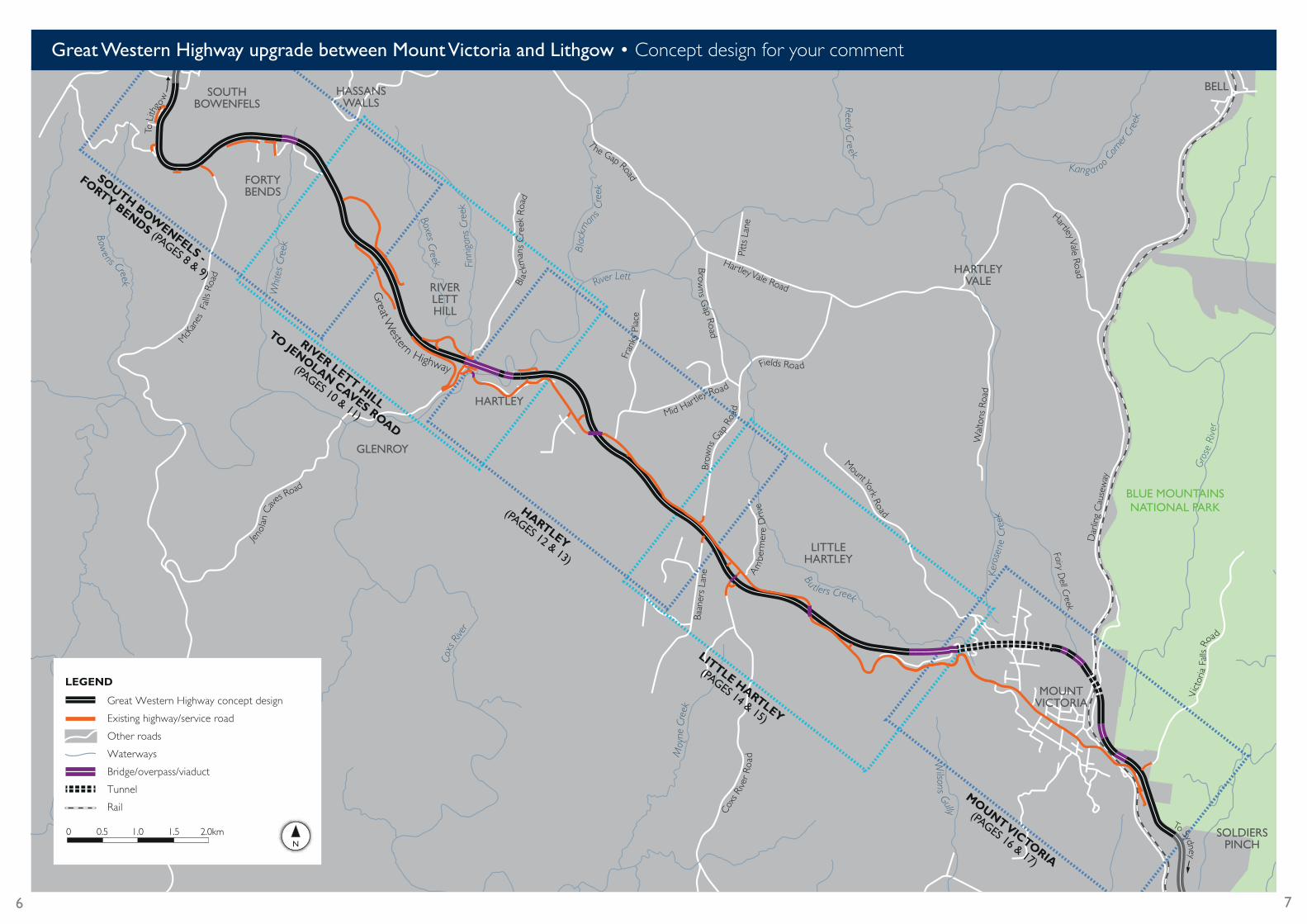
Road boundaries for long term improvements RMS has developed a concept design for the longer-term upgrade of the Great Western Highway between Mount Victoria and Lithgow. The purpose of this concept design is to identify road boundaries that can be reserved for long-term improvements. These boundaries will be provided to theBlueMountainsCityandLithgowCitycouncilsasakeyinput to future land use planning.
The proposed road boundaries include the road formation, batters and retaining structures, drainage structures, landscaping and space for maintenance activities.
The concept design for the road boundaries extends betweenSoldiersPinch,about400metreseastofBrowntownOvalatMountVictoriaandMagpieHollowRoadatSouthBowenfels.
The concept design has been primarily developed within the preferred route buffer zone displayed in May 2010. In some areas it has been necessary to go beyond the preferred route buffer zone. The reasons for this include improved road alignment, extensions to the east of BrowntownOvalandwestofMcKanesFallsRoad, service road connections, upgraded side roads and water quality measures.
Theconceptdesignintegratesroadsafety,freightefficiencyand local access improvements and includes environmental design considerations. While the concept design varies between two and four lanes, the road boundaries will be set for four lanes along the entire length of the highway to allow for long-term improvements.
Review of Great Western Highway Upgrades West of Katoomba
INDEPENDENT REVIEW Date 19 January 2012
2
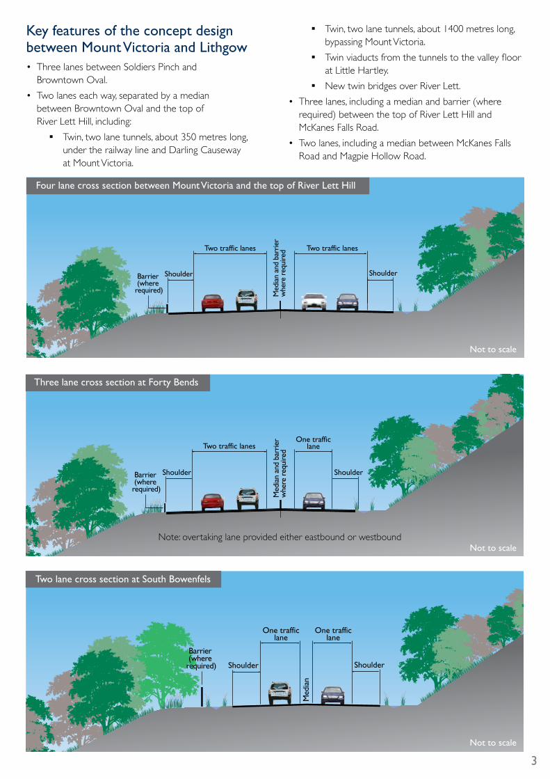
Key features of the concept design between Mount Victoria and Lithgow• ThreelanesbetweenSoldiersPinchand BrowntownOval.
• Twolaneseachway,separatedbyamedian betweenBrowntownOvalandthetopof River Lett Hill, including: � Twin,twolanetunnels,about350metreslong,
under the railway line and Darling Causeway at Mount Victoria.
� Twin,twolanetunnels,about1400metreslong,bypassing Mount Victoria.
� Twinviaductsfromthetunnelstothevalleyfloorat Little Hartley.
� New twin bridges over River Lett.
• Threelanes,includingamedianandbarrier(whererequired) between the top of River Lett Hill and McKanesFallsRoad.
• Twolanes,includingamedianbetweenMcKanesFallsRoad and Magpie Hollow Road.
Two traffic lanesOne traffic
lane
ShoulderShoulder
Med
ian
and
barr
ier
whe
re r
equi
red
Barrier (where
required)
Note: overtaking lane provided either eastbound or westbound
Three lane cross section at Forty Bends
Two traffic lanes Two traffic lanes
Shoulder ShoulderBarrier (where
required) Med
ian
and
barr
ier
whe
re r
equi
red
Four lane cross section between Mount Victoria and the top of River Lett Hill
Not to scale
Not to scale
One traffic lane
One traffic lane
ShoulderShoulder
Med
ian
Barrier (where
required)
Two lane cross section at South Bowenfels
Not to scale
3
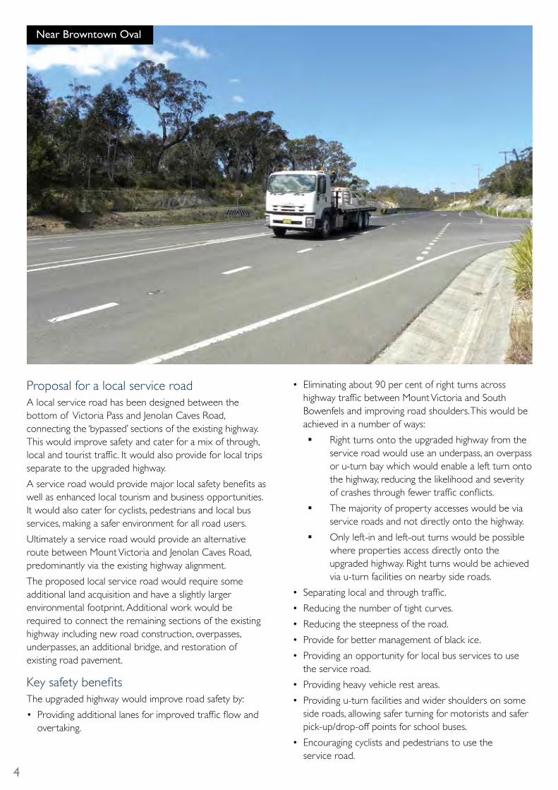
Near Browntown Oval
Proposal for a local service roadA local service road has been designed between the bottom of Victoria Pass and Jenolan Caves Road, connecting the ‘bypassed’ sections of the existing highway. This would improve safety and cater for a mix of through, localandtouristtraffic.Itwouldalsoprovideforlocaltripsseparate to the upgraded highway.
Aserviceroadwouldprovidemajorlocalsafetybenefitsaswell as enhanced local tourism and business opportunities. It would also cater for cyclists, pedestrians and local bus services, making a safer environment for all road users.
Ultimatelyaserviceroadwouldprovideanalternativeroute between Mount Victoria and Jenolan Caves Road, predominantly via the existing highway alignment.
The proposed local service road would require some additional land acquisition and have a slightly larger environmental footprint. Additional work would be required to connect the remaining sections of the existing highway including new road construction, overpasses, underpasses, an additional bridge, and restoration of existing road pavement.
KeysafetybenefitsThe upgraded highway would improve road safety by:
• Providingadditionallanesforimprovedtrafficflowandovertaking.
• Eliminatingabout90percentofrightturnsacrosshighwaytrafficbetweenMountVictoriaandSouthBowenfelsandimprovingroadshoulders.Thiswouldbeachieved in a number of ways: � Right turns onto the upgraded highway from the
service road would use an underpass, an overpass or u-turn bay which would enable a left turn onto the highway, reducing the likelihood and severity ofcrashesthroughfewertrafficconflicts.
� The majority of property accesses would be via service roads and not directly onto the highway.
� Onlyleft-inandleft-outturnswouldbepossiblewhere properties access directly onto the upgraded highway. Right turns would be achieved via u-turn facilities on nearby side roads.
• Separatinglocalandthroughtraffic.
• Reducingthenumberoftightcurves.
• Reducingthesteepnessoftheroad.
• Provideforbettermanagementofblackice.
• Providinganopportunityforlocalbusservicestousethe service road.
• Providingheavyvehiclerestareas.
• Providingu-turnfacilitiesandwidershouldersonsomeside roads, allowing safer turning for motorists and safer pick-up/drop-off points for school buses.
• Encouragingcyclistsandpedestrianstousethe service road.
4
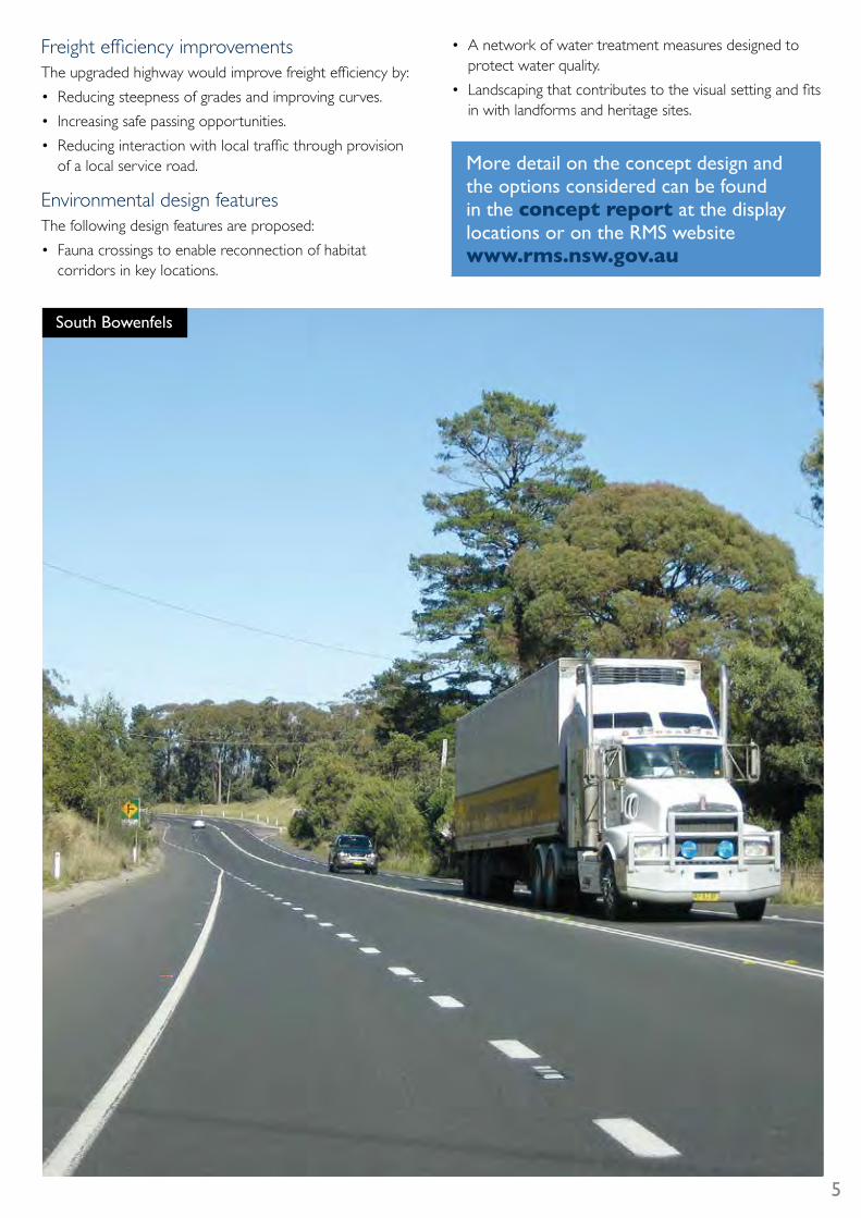
FreightefficiencyimprovementsTheupgradedhighwaywouldimprovefreightefficiencyby:
• Reducingsteepnessofgradesandimprovingcurves.
• Increasingsafepassingopportunities.
• Reducinginteractionwithlocaltrafficthroughprovisionof a local service road.
Environmental design featuresThe following design features are proposed:
• Faunacrossingstoenablereconnectionofhabitatcorridors in key locations.
• Anetworkofwatertreatmentmeasuresdesignedtoprotect water quality.
• Landscapingthatcontributestothevisualsettingandfitsin with landforms and heritage sites.
More detail on the concept design and the options considered can be found in the concept report at the display locations or on the RMS website www.rms.nsw.gov.au
South Bowenfels
5
Dar
ling
Cau
sew
ay
Hartley Vale Road
Wal
tons
Roa
d
Pitt
s La
ne
Fields Road
Am
berm
ere
Driv
e
Fairy Dell Creek
Vict
oria
Fal
ls Ro
ad
T
he Gap Road
Browns G
ap Road
Mid Hartley
Road
Fran
ks P
lace
Bla c
kman
s C
reek
Roa
d
Baan
ers
Lane
Hartley Vale Roa d
Brow
ns G
ap R
oad
Mount York Road
McK
anes
Fal
ls Ro
ad
Cox
s Riv
er R
oad
Jenol
an C
av
es Road
To Sydney
Great W
estern Highway
To L
ithgo
w
Finn
igan
s Cr
eek
Bla
ckm
an
s C
reek
River Lett
Reedy Cree k
Kangaroo C
orne
r Cre
ek
Gros
e Ri
ver
Kero
sene
Cre
ek
Wilsons Gully
Moy
ne C
reek
Coxs
Rive
r
Yorke
ys Cre
ek
Whi
tes
Cree
k
Boxes Creek
Bow
ens Creek
HARTLEY
GLENROY
FORTYBENDS
LITTLEHARTLEY
SOLDIERSPINCH
MOUNTVICTORIA
HARTLEYVALE
BLUE MOUNTAINSNATIONAL PARK
BELLHASSANSWALLS
RIVER LETT HILL
SOUTHBOWENFELS
SOUTH BOWENFELS -
FORTY BENDS (PAGES 8 & 9)
RIVER LETT HILL
TO JENOLAN CAVES ROAD
(PAGES 10 & 11)
HARTLEY
(PAGES 12 & 13)
LITTLE HARTLEY
(PAGES 14 & 15)
MOUNT VICTORIA
(PAGES 16 & 17)
Great Western Highway concept design
Existing highway/service road
Other roads
Waterways
Bridge/overpass/viaduct
Tunnel
Rail
LEGEND
0 0.5 1.0 1.5 2.0km
Bu tlers Creek
Great Western Highway upgrade between Mount Victoria and Lithgow • Concept design for your comment
6 7
Mudgee Street
Great Western Highway concept design
Existing highway/road retained
New/upgraded service road
Existing road removed/unused
Waterways
Bridge/viaduct/overpass
Roundabout
Cul-de-sac
U-turn bay
Proposed road boundary
Road fill batter
Road cut batter
Water quality basins (indicative location)
Other roads
LEGEND
0 100 200 300 400 500M
No right turnonto highway
No right turnonto highway
Magpie Hollow Road
Forty Bends Roa
d
Whites Creek
Whites Creek
Gre
at W
estern
Highway
Hassa ns W
alls
Ro
ad
O
ld Bathurst Road
SOUTH BOWENFELS
LITHGOWHASSANS
WALLS
FORTY BENDS
McKanes Falls Road
Daintree Close
To Sydney
Emergency services allowed
Great W
estern Highw
ay
One lane westbound and two lanes eastbound
Improve alignment through Forty
Bends and widen to three lanes
New bridge across Whites Creek
Upgrade existing local road network connections One lane westbound and
two lanes eastbound
Two lanes westbound
and one lane eastbound
One lane westbound and one lane eastbound
Two lanes westboundand one lane eastbound
Two lanes eastboundand two lanes westbound
Provide for wider traffic separation at South Bowenfels
Lane configuration changesU-turn bay
U-turn bay
Two lanes eastbound
One lane westbound
Two lanes westbound
McKanes Falls Road
Lane configuration changes
Two
lane
s w
estb
ound
One
lane
eas
tbou
ndOne lane eastbound
One lan
e west
bound
Forty
Bends Road
Two lanes westboundTwo lanes eastbound
Bridge
U-turn bay
One lane
eastbound
Lane configuration changes
U-turn bay
Highway concept design
Retained or upgraded service roads
Highway concept design
Retained or upgraded service roads
Highway concept design
Retained or upgraded service roads
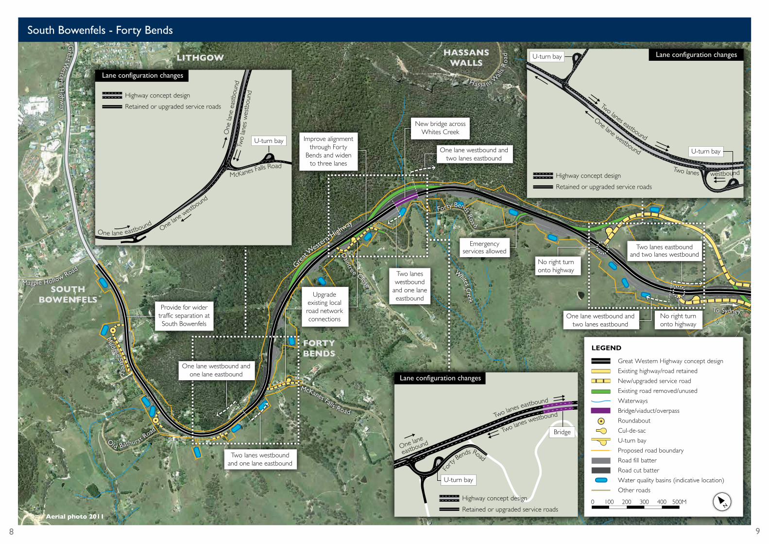
South Bowenfels - Forty Bends
Aerial photo 2011
8 9
Rive
r Lett Old Bathurst
Road
Great Western Highway
Boxes Creek
Finnegans Creek
Boxes Creek
RIVER LETT HILL
HARTLEY
Blackmans C
reek Road
No right turnonto/off highway
No access to highway
To Lithgow
No right turnonto highway
To Sydney
Two lanes eastboundand two lanes westbound
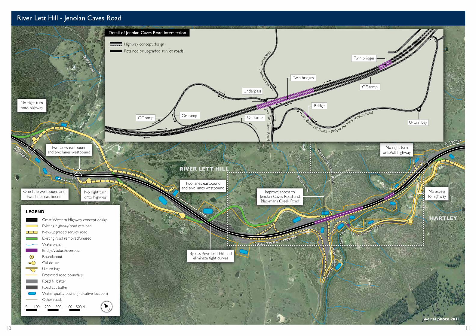
Bypass River Lett Hill and eliminate tight curves
Improve access to Jenolan Caves Road and Blackmans Creek Road
Jeno
lan C
aves
Roa
d
No right turnonto highway
One lane westbound and two lanes eastbound
Two lanes eastboundand two lanes westbound
Highway concept design
Retained or upgraded service roads
Off-ramp
U-turn bay
Bridge
Twin bridges
Twin bridges
Underpass
On-rampOn-rampOff-ramp
Jenolan Caves Road
Blackmans C
reek Road
Old Bathurst Road - proposed
local
service road
Detail of Jenolan Caves Road intersection
Great Western Highway concept design
Existing highway/road retained
New/upgraded service road
Existing road removed/unused
Waterways
Bridge/viaduct/overpass
Roundabout
Cul-de-sac
U-turn bay
Proposed road boundary
Road fill batter
Road cut batter
Water quality basins (indicative location)
Other roads
LEGEND
0 100 200 300 400 500M
River Lett Hill - Jenolan Caves Road
Aerial photo 2011
10 11
Old Bathurst
Road
Carroll D
rive
River Lett
Mid H
artley Road
Heavy vehicle rest area
Heavy vehicle rest area
HARTLEY
LITTLE HARTLEY
Baaners Lane
Browns G
ap Road
Butlers Creek
To LithgowWheeler Place
No right turnonto/off highway
Improve alignment and access for residents and visitors through Hartley
Connect Hartley and Jenolan Caves Road via
Old Bathurst Road
To Sydney
Great Western Highway
Two lanes eastboundand two lanes westbound
Kelly S
treet
Highway concept design
Retained or upgraded service roads
No right turnonto/off highway
Heavy vehicle rest area
Proposed local service road
Car
roll
Driv
e
Overpass
Heavy vehicle rest area
No right turn onto/off highway
Mid H
artley Road
Detail of local access at Hartley
Great Western Highway concept design
Existing highway/road retained
New/upgraded service road
Existing road removed/unused
Waterways
Bridge/viaduct/overpass
Roundabout
Cul-de-sac
U-turn bay
Proposed road boundary
Road fill batter
Road cut batter
Water quality basins (indicative location)
Other roads
LEGEND
0 100 200 300 400 500M
Hartley
Aerial photo 2011
12 13
Butlers Creek
Butler
s Cree
k
Browns G
ap Road
Moyne Creek
Twin tunnels
LITTLE HARTLEY
Bonny Hills
Drive
Baaners Lane
Collits Place
Coxs River Road
Mor
ris
Pla
ce
Mount York Road
Great Western Highway
Butlers Creek
Dicker D
rive
Amberm
ere Drive
To Lithgow
To Sy
dney
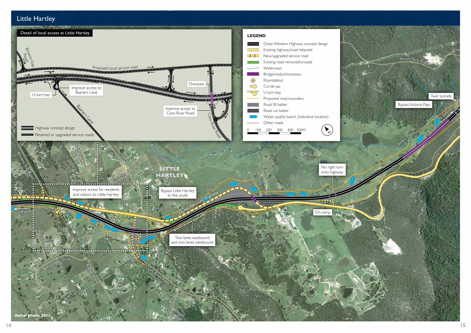
Bypass Little Hartley to the south
Bypass Victoria Pass
No right turnonto highway
Improve access for residents and visitors to Little Hartley
Apple Tree Lane
On-ramp
Two lanes eastboundand two lanes westbound
Highway concept design
Retained or upgraded service roads
RoadBrow
ns Gap
Baaners Lane
U-turn bay
Improve access to Baaners Lane
Proposed local service road
Improve access to Coxs River Road C
oxs River Road
Detail of local access at Little Hartley
Overpass
Great Western Highway concept design
Existing highway/road retained
New/upgraded service road
Existing road removed/unused
Waterways
Bridge/viaduct/overpass
Roundabout
Cul-de-sac
U-turn bay
Proposed road boundary
Road fill batter
Road cut batter
Water quality basins (indicative location)
Other roads
LEGEND
0 100 200 300 400 500M
Little Hartley
Aerial photo 2011
14 15
Butlers Creek
Fairy Dell Creek
Fairy Bower Creek
Grose River
Twin tunnels
BrowntownOval
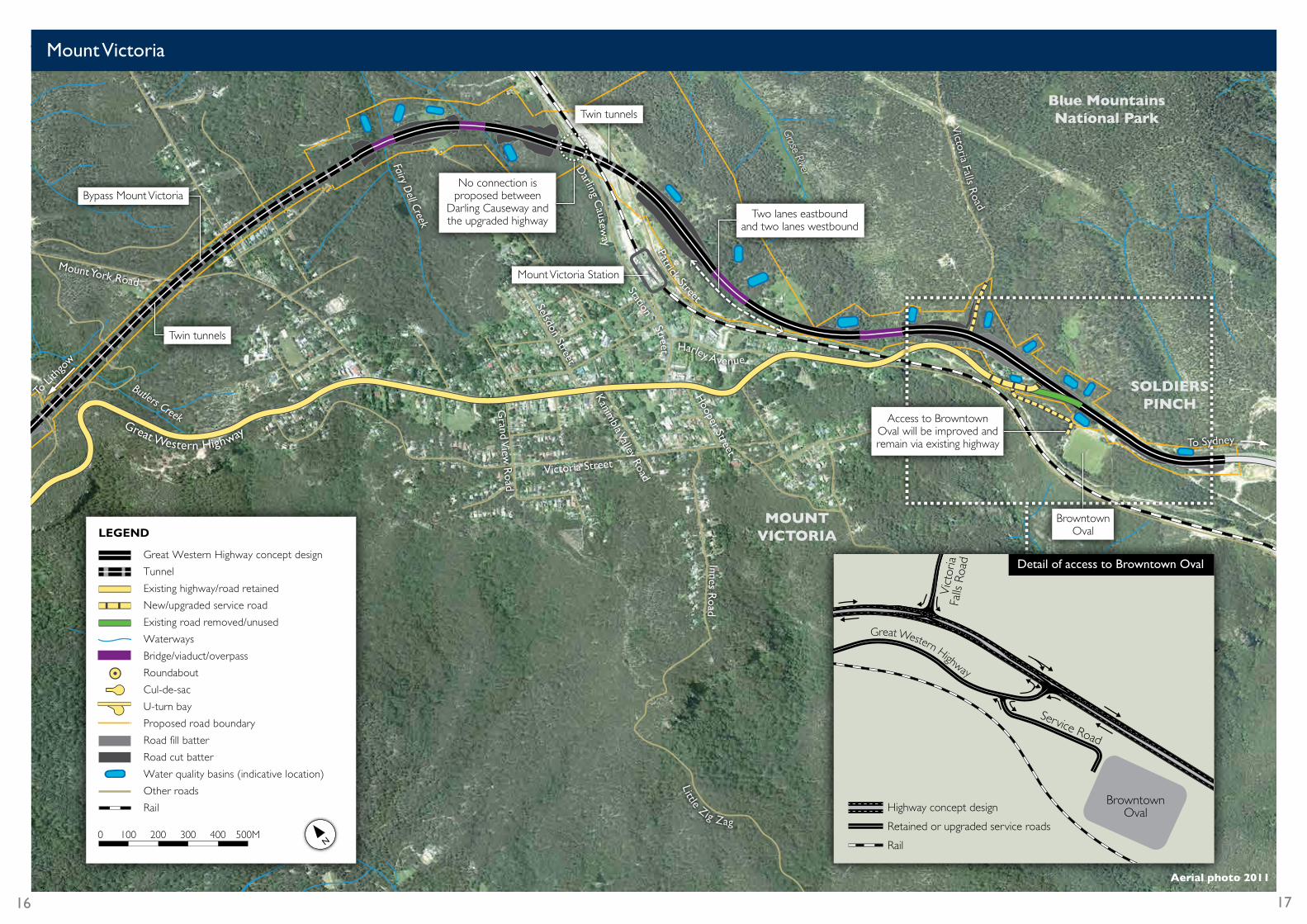
Access to BrowntownOval will be improved and remain via existing highway
No connection is proposed between
Darling Causeway and the upgraded highway
Victoria Falls R
oad
To Sydney
MOUNT VICTORIA
SOLDIERSPINCH
Blue Mountains National Park
Harley Avenue
Mount York Road
Great Western Highway
To Li
th
gow
Street
Two lanes eastboundand two lanes westbound
Darling C
auseway
Bypass Mount Victoria
Twin tunnels
Victoria Street
Selsdon Street
Station
Kanimbla Valley Road
Hooper Street
Grand V
iew R
oad
Innes Road
Little Zig Zag
Patrick Street
Mount Victoria Station
Vic
toria
Great Western Highway
Fal
ls Ro
ad
Service Road
BrowntownOvalHighway concept design
Retained or upgraded service roads
Rail
Detail of access to Browntown OvalGreat Western Highway concept design
Tunnel
Existing highway/road retained
New/upgraded service road
Existing road removed/unused
Waterways
Bridge/viaduct/overpass
Roundabout
Cul-de-sac
U-turn bay
Proposed road boundary
Road fill batter
Road cut batter
Water quality basins (indicative location)
Other roads
Rail
LEGEND
0 100 200 300 400 500M
Mount Victoria
Aerial photo 2011
16 17

Mudgee Street
Great Western Highway concept design
Existing highway/road retained
New/upgraded service road
Existing road removed/unused
Waterways
Bridge/viaduct/overpass
Roundabout
Cul-de-sac
U-turn bay
Proposed road boundary
Road fill batter
Road cut batter
Water quality basins (indicative location)
Other roads
LEGEND
0 100 200 300 400 500M
No right turnonto highway
Magpie Hollow Road
Forty Bends Roa
d
Whites Creek
Whites Creek
Gre
at W
estern
Highway
Hassa ns W
alls
Ro
ad
O
ld Bathurst Road
SOUTH BOWENFELS
LITHGOWHASSANS
WALLS
FORTY BENDS
McKanes Falls Road
Daintree Close
To Sydney
Great W
estern Highw
ay
One lane westbound and two lanes eastbound
Two lanes westboundand one lane eastbound
One lane westbound and one lane eastbound
Two lanes westboundand one lane eastbound
Two lanes eastboundand two lanes westbound
Forty Bends
Three lane upgrade of Forty Bends Realigning the highway at Forty Bends would improve safety and reliability of travel, reduce the likelihood of crashes and potential road closures in winter months due to the formation of black ice.
Other safety benefits would include reduced grades and smoother curves.
Planning and field investigations are already well advanced and work has started on an environmental impact assessment for this section of the highway upgrade. The environmental impact assessment will be displayed for community comment later in 2012.
RMS will also start discussions with potentially affected landowners in coming weeks.
Forty Bends environmental impact assessmentRMS is preparing an environmental impact assessment (Review of Environmental Factors – REF) of the proposed upgrade of the Great Western Highway at Forty Bends. Community feedback on the concept design will be incorporated into the environmental impact assessment.
The environmental impact assessment will:
• Describe the proposed upgrade and its features.
• Identify and assess the potential environmental impact associated with the design.
• Identify mitigation and management measures to reduce any impacts of construction and ongoing operation of the upgrade.
• Consider all feedback on the design.
The REF will be displayed for community comment later in 2012. RMS will consult directly with all property owners affected by the upgrade of Forty Bends.
18
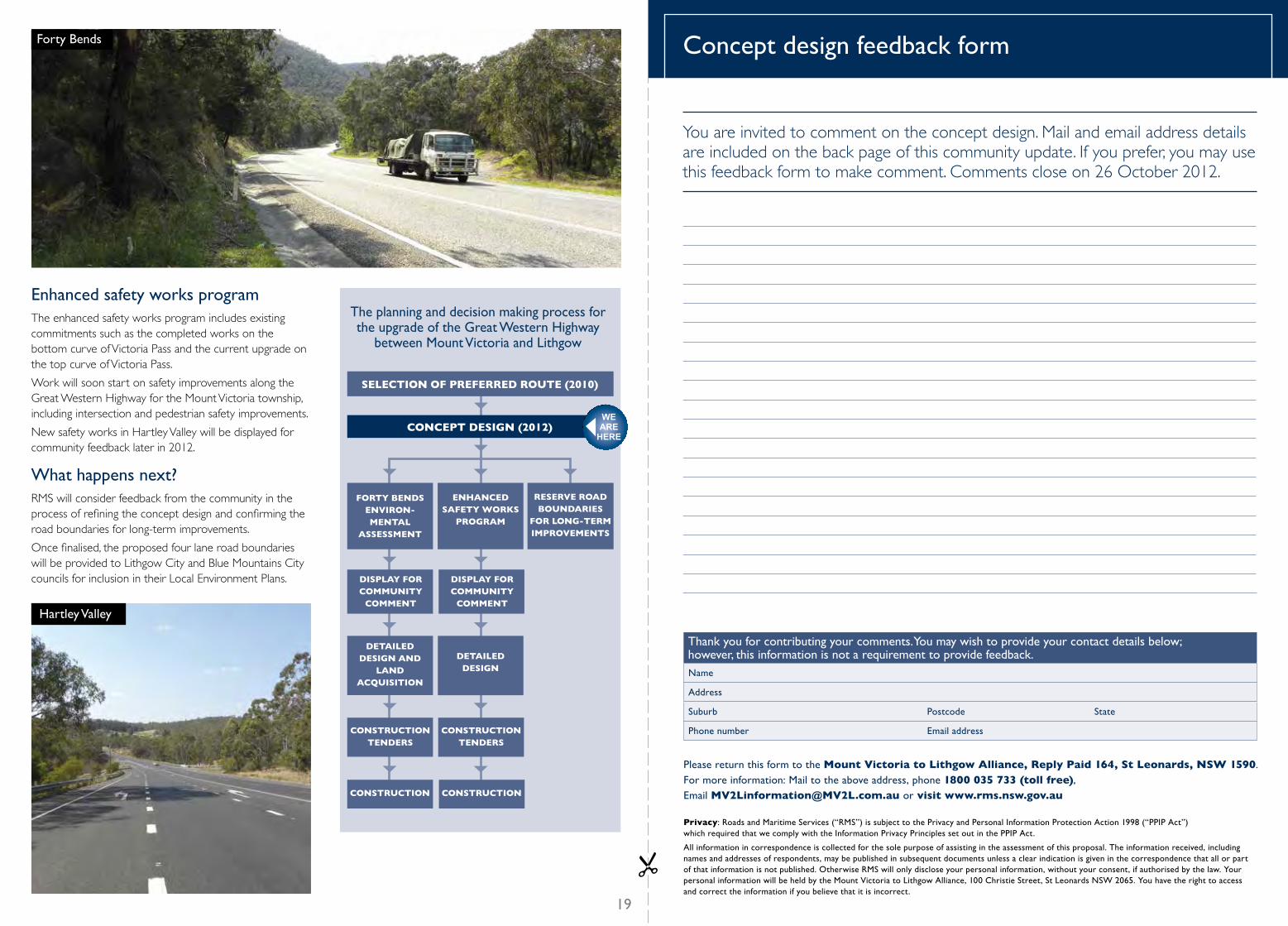
SELECTION OF PREFERRED ROUTE (2010)
RESERVE ROAD BOUNDARIES
FOR LONG-TERM IMPROVEMENTS
ENHANCED SAFETY WORKS
PROGRAM
CONCEPT DESIGN (2012)
FORTY BENDS ENVIRON- MENTAL
ASSESSMENT
DETAILED DESIGN AND
LAND ACQUISITION
DETAILED DESIGN
CONSTRUCTION TENDERS
CONSTRUCTION TENDERS
CONSTRUCTION CONSTRUCTION
DISPLAY FOR COMMUNITY
COMMENT
DISPLAY FOR COMMUNITY
COMMENT
The planning and decision making process for the upgrade of the Great Western Highway
between Mount Victoria and Lithgow
WE ARE
HERE
Thank you for contributing your comments. You may wish to provide your contact details below; however, this information is not a requirement to provide feedback.Name
Address
Suburb Postcode State
Phone number Email address
Please return this form to the Mount Victoria to Lithgow Alliance, Reply Paid 164, St Leonards, NSW 1590. For more information: Mail to the above address, phone 1800 035 733 (toll free), Email [email protected] or visit www.rms.nsw.gov.au
Privacy: Roads and Maritime Services (“RMS”) is subject to the Privacy and Personal Information Protection Action 1998 (“PPIP Act”) which required that we comply with the Information Privacy Principles set out in the PPIP Act.
All information in correspondence is collected for the sole purpose of assisting in the assessment of this proposal. The information received, including names and addresses of respondents, may be published in subsequent documents unless a clear indication is given in the correspondence that all or part of that information is not published. Otherwise RMS will only disclose your personal information, without your consent, if authorised by the law. Your personal information will be held by the Mount Victoria to Lithgow Alliance, 100 Christie Street, St Leonards NSW 2065. You have the right to access and correct the information if you believe that it is incorrect.
Concept design feedback form
You are invited to comment on the concept design. Mail and email address details are included on the back page of this community update. If you prefer, you may use this feedback form to make comment. Comments close on 26 October 2012.
Forty Bends
Enhanced safety works program The enhanced safety works program includes existing commitments such as the completed works on the bottom curve of Victoria Pass and the current upgrade on the top curve of Victoria Pass.
Work will soon start on safety improvements along the Great Western Highway for the Mount Victoria township, including intersection and pedestrian safety improvements.
New safety works in Hartley Valley will be displayed for community feedback later in 2012.
What happens next? RMS will consider feedback from the community in the process of refining the concept design and confirming the road boundaries for long-term improvements.
Once finalised, the proposed four lane road boundaries will be provided to Lithgow City and Blue Mountains City councils for inclusion in their Local Environment Plans.
Hartley Valley
19
To mail this feedback form fold along the dotted line and seal with clear tape.Mail your completed form (no stamp required) to address below.
FOLD HERE FIRST
FOLD HERE SECOND
For more information:
Mail to Mount Victoria to Lithgow Alliance, PO Box 164, St Leonards NSW 1590 T 1800 035 733 (toll free) E [email protected] or visit www.rms.nsw.gov.au/roadprojects
July 2012RMS 12.183
Width: 110 mm X Length: 220 mm Note: All components must be printed.The artwork components must not be re-scaled. Re-scaling will create processingproblems.
Delivery Address:PO Box 164ST LEONARDS NSW 1590
Sinclair Knight MerzReply Paid 164ST LEONARDS NSW 1590
Filename: D56595875010110220Y100916.pdf date: 16/09/2010 15:49:43
Please note:• It is the customer's responsibility to check that the artwork is correct, please check the delivery address details and the addressee details below the barcode. Contact Australia Post if any changes are
required.• Failure to adhere to correct addressing and formatting standards will result in higher customer charges or cancellation of service.• Refer to the Reply Paid Service Guide or visit www.auspost.com.au/replypaid• Please check the artwork details thoroughly. Australia Post is not responsible for any errors.
Summary: Envelope Paper Requirements:- weight of 65 to 100gsm;- thickness of 0.08 to 0.18 mm;- stiffness: machine direction of 3 mN; and,- stiffness: cross direction of 1.5mN.
No print content can appear in the bottom 15 mm on the front of the article or 20mm on therear of the article.
WARNINGChanges to this artwork not complying withReply Paid Service Guidelines may result incancellation of your Reply Paid service.
Mount Victoria to Lithgow AllianceReply Paid 164ST LEONARDS NSW 1590
How you can be involved
Display locationsThe concept design is on display until 26 October 2012. Displays will be at the following locations:
Blue Mountains City Council 2-6 Civic Place, Katoomba Monday to Friday from 8.30am to 5pm.
Katoomba Library Town Centre Arcade Katoomba Street, Katoomba Monday to Friday from 10am to 5.30pm and Saturday from 9am to 4pm.
Lithgow City Council 180 Mort Street, Lithgow Monday to Friday from 8.30am to 4.30pm.
Lithgow Library 157 Main Street, Lithgow Monday to Friday from 9am to 6pm and Saturday from 9am to noon.
Lithgow Motor Registry Shop 51, Valley Plaza Corner of Lithgow and Bent Streets, Lithgow Monday to Friday from 9am to 5pm.
RMS websiteThe concept report is available on the RMS website at www.rms.nsw.gov.au/roadprojects.
Community meetingsRMS representatives will discuss the upgrade priorities and concept design (particularly Forty Bends) at:
Hartley School Building Mid Hartley Road, Hartley Wednesday 1 August 2012 Noon to 2pm
Mount Victoria Public School Great Western Highway, Mount Victoria Wednesday 1 August 2012 6pm to 8pm.
The project team will be presenting the concept design followed by time for discussion at the following locations. This will provide an opportunity for the community to look at the concept design in more detail.
Hartley School Building Mid Hartley Road, Hartley (focus on River Lett Hill, Hartley and Little Hartley) Thursday 9 August 2012 Noon to 2pm.
Mount Victoria Public School Great Western Highway, Mount Victoria (focus on Mount Victoria) Thursday 9 August 2012 6pm to 8pm.
Union Theatre 63-65 Bridge Street, Lithgow (focus on Forty Bends and South Bowenfels) Saturday 11 August 2012 10am to Noon meeting and 1pm to 3pm staffed display.
The project team will remain at the venue to discuss any matters the community and stakeholders may have regarding the concept design.
Feedback Feedback on the concept design will be received until Friday 26 October 2012.
A feedback form is provided in this community update for your comment. Alternatively you can send your written comments to the Mount Victoria to Lithgow Alliance at the mail and email addresses shown below.
Mount Victoria to Lithgow Great Western Highway UpgradeConcept design
July 2012
RMS 12.184 ISBN 978-1-922040-80-0
Concept report