Embed Size (px)
Citation preview

Comprehensive PlanAdopted May 22, 2017


1415 Highway 6 South – Suite D-100 | Sugar Land, TX 77478 | Phone: 281.242.2960
www.kendigkeast.com
Elk Grove, CA | Sturgeon Bay, WI | Sugar Land, TX
June 12, 2017
Mr. M. Christopher Peifer City Manager - City of West University Place 3800 University Boulevard West University Place, Texas 77005
Dear Chris:
We are pleased to submit this final version of the newly updated City of West University Place Comprehensive Plan, as adopted by City Council on May 22, 2017. The updated plan document was prepared in accordance with our Professional Services Agreement with the City.
The plan update process enabled the City’s Zoning and Planning Commission (ZPC) to fulfill its responsibility under the City Charter to “recommend to the Council plans for the physical development of the city.” This includes considerations involving land use and housing, transportation, public infrastructure and facilities, and parks and recreation, among others. The updated plan also provides essential support for the City’s zoning and other development regulations as Texas Local Government Code Chapter 211 specifies that “zoning regulations must be adopted in accordance with a comprehensive plan.” The new plan:
Reinforces key planning themes and priorities of local officials and residents, including: protecting West U’s primarily residential character, managing external influences on an enclave city (e.g., traffic, nearby redevelopment, storm drainage), emphasizing the safety of pedestrians and cyclists, and preserving Town Center as a community focal point and gathering place, anchored by West University Elementary.
Reflects community and leadership input obtained through a series of small-group discussion sessions (October 2016); a community-wide public meeting and related online survey that drew 110 responses (October-November 2016); and six work sessions with the ZPC (September 2016-March 2017), which culminated in a joint public hearing before the Council and ZPC (April 2017) prior to plan adoption.
Includes background and statistics that provide a snapshot of West University Place as it was in 2016, and relative to the time of the last plan update in 2000 (an Existing City Report included in this binder also highlights community accomplishments since 2000, and ongoing and new opportunities and challenges for the years ahead).
On behalf of our firm, we sincerely appreciated this further opportunity to lend our professional skills and experience to your ongoing community planning efforts. We look forward to seeing the continued enhancement of West University Place in the years ahead.
Respectfully submitted,
KENDIG KEAST COLLABORATIVE
Gary Mitchell, AICP President


ACKNOWLEDGEMENTS (May 2017)
ACKNOWLEDGEMENTS West University Place Comprehensive Plan
City Council Susan Sample Mayor Bob Kelly Mayor Pro Tem Burt Ballanfant Councilmember Brennan Reilly Councilmember Mardi Turner Councilmember
Zoning and Planning Commission Richard Wilson Chair Michael McEnany Vice Chair David Kuykendall Secretary John Cutrer Member Bob Higley Member Mac Jensen Member Mimi Tsai Member
City Staff M. Christopher Peifer City Manager Alan Petrov City Attorney Thelma Gilliam City Secretary Dave Beach Public Works Director Debbie Scarcella City Planner
Community Planning Consultant Kendig Keast Collaborative
Bret C. Keast, AICP Owner | CEO Gary Mitchell, AICP President (Project Manager) Luis Núñez Senior Associate Janis Burall, AICP Senior Associate
Thanks Also To…
Individual residents, property owners, business owners and others who participated in and contributed their insights and ideas
to the City’s comprehensive planning process.


TABLE OF CONTENTS (May 2017)
TABLE OF CONTENTS West University Place Comprehensive Plan
As Codified in Appendix D, City Code of Ordinances
Article I. - Purpose ........................................................................................... 1 of 6 Section 1.01. - Introduction. ....................................................................................... 1 of 6 Section 1.02. - Mission Statement. ............................................................................ 1 of 6
Article II. - Historical ........................................................................................ 1 of 6 Article III. - Demographics ............................................................................... 2 of 6
Section 3.01. - Population Trends. ............................................................................. 2 of 6 Article IV. - Land Use ....................................................................................... 2 of 6
Section 4.01. - Single-Family Residential. .................................................................. 2 of 6 Section 4.02. - Non Single-Family Residential. ........................................................... 3 of 6 Section 4.03. - Parks and Open Space. ...................................................................... 3 of 6 Section 4.04. - Zoning Ordinance. .............................................................................. 3 of 6
Article V. - Peripheral Development ................................................................. 3 of 6 Section 5.01. - General. .............................................................................................. 3 of 6 Section 5.02. - Signs. .................................................................................................. 4 of 6
Article VI. - Traffic ........................................................................................... 4 of 6 Section 6.01. - General. .............................................................................................. 4 of 6 Section 6.02. - Maintenance. ..................................................................................... 4 of 6
Article VII. Public Utilities & Facilities .............................................................. 4 of 6 Section 7.01. - General. .............................................................................................. 4 of 6 Section 7.02. - Lighting. .............................................................................................. 4 of 6 Section 7.03. - Sidewalks. .......................................................................................... 4 of 6 Section 7.04. - Facilities. ............................................................................................ 5 of 6
Article VIII. - Town Center ................................................................................ 5 of 6 Section 8.01. - General. .............................................................................................. 5 of 6 Section 8.02. - Town Center Commercial District. ..................................................... 5 of 6
Article IX. - Local Public Institutions & Places of Worship .................................. 5 of 6 Section 9.01. - General. .............................................................................................. 5 of 6 Section 9.02. - West University Elementary. ............................................................. 5 of 6
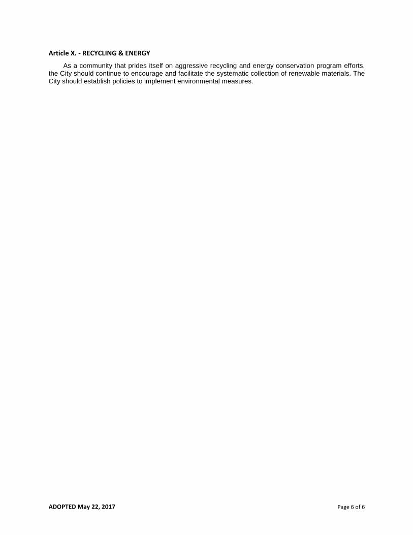
Article X. - Recycling & Energy ......................................................................... 6 of 6
Existing City Report Supplement to Comprehensive Plan
Community Accomplishments ....................................................................... 1 of 19 Physical Characteristics and Context .............................................................. 3 of 19
Illustration: Nodes ............................................................................................... 5 of 19 Illustration: Districts ............................................................................................ 6 of 19 Illustration: Paths ................................................................................................. 7 of 19 Illustration: Edges ................................................................................................ 8 of 19
Key Numbers for West University Place .................................................................. 10 of 19 Other Essential Statistics for West University Place ................................................ 12 of 19
Key Opportunities and Challenges ................................................................. 14 of 19


ADOPTED May 22, 2017 Page 1 of 6
APPENDIX D - COMPREHENSIVE PLAN
As adopted by City of West University Place Ordinance No. 2033, passed on second and final reading May 22, 2017.
Article I. - PURPOSE
Section 1.01. - Introduction.
The Comprehensive Plan, hereafter referred to as the "Plan," is designed to promote the general health, safety, and public welfare of the residents of West University Place. Its purpose is to guide the long-range development of the City and good government. The Plan is a policy document to be used as a framework for implementing community goals and objectives and a guide for decisions involving capital improvements, zoning and subdivision matters, neighborhood safety, community appearance, regulatory issues and other matters of similar importance. Unless otherwise specified by the City Charter, the relationship between this Plan and the City's various development regulations is defined by separate ordinance. That ordinance, which is codified in Chapter 1 of the City's Code of Ordinances, also provides standards for determining the consistency required between this Plan and development regulations and establishes procedures for adopting and amending a comprehensive plan.
Section 1.02. - Mission Statement.
Inasmuch as the City is almost completely developed and most of its land area is devoted to single-family residential uses, the Plan's goal is to maintain and encourage the traditional single-family residential character of West University Place as a friendly, safe, economically stable and attractive community. It is also intended to minimize any adverse effects of non-residential development and uses. Maintaining a strong sense of neighborhood and community are fundamental priorities, as is preserving the mature tree canopy that is a signature element of the community’s character and image. Crime prevention and residential security should remain a prime focus of municipal government. To the extent it can, the City should also safeguard the community against external factors that can affect residents’ quality of life, such as intensive development and redevelopment in adjacent jurisdictions, major street and infrastructure projects by other public agencies, and lingering blight removal and revitalization needs in the vicinity of West University Place.
Article II. - HISTORICAL West University was created from an area of swamp land west of Rice University off Old Spanish
Trail. In 1912, the governor of Tennessee, Ben Hooper, bought 750 acres for a community of country homes outside the City of Houston. The area was advertised as an exclusive neighborhood, but it was not initially popular. Most of the first residents were families who moved to Houston so the men could work at Rice University as professors. Many publications advertised West University Place as an attractive cozy neighborhood. Development began in the early 1920's. The area was described by many as a virtual treeless prairie. In the Second Addition of West University Place, the builder tried to make the area seem more prestigious by naming the streets after colleges and universities. Many of the original homes were two-story structures, small cottages, and bungalows. A rural-like atmosphere derived from numerous fruit, flower and vegetable gardens. West University Place was incorporated in 1924 with approximately 40 families. Incorporation brought higher taxes, a city hall, fire station, street improvements with curbs and gutters, and organized police and fire protection. As a Home Rule Charter city, the municipality has a Council-Manager form of government. Since the 1980's, West University Place has experienced significant private urban development. Many of the original bungalows and cottages have been replaced with large two-story custom-built homes.

ADOPTED May 22, 2017 Page 2 of 6
Article III. - DEMOGRAPHICS
Section 3.01. - Population Trends.
(a) The population of West University Place was greatest in the 1950's when the count peaked a bit over 17,000. A low of 12,010 was reached in the 1980's. The last census count in 2010 showed 14,787 residents and 5,548 housing units.
Demographic Indicators for West University Place (2000-2015)
Year
Population
Median Age
Age 19 or Less
Age 65 or More
2015 (estimated) 15,400 42.4 30.9% 11.0%
2000 14,211 39.3 31.2% 7.6%
SOURCE: U.S. Census Bureau, Texas State Data Center, Houston-Galveston Area Council. (b) This Plan recognizes that, as a largely built-out community, West University Place will not show any
significant gains in population or housing units in the years ahead. In fact, there could be fewer single-family homes in the future if more buyers choose to purchase and consolidate adjacent lots for additional space and yard area. Census 2010 reported 5,548 housing units in the city, and as of October 2016, the City showed approximately 5,500 active residential water accounts. As part of its regional growth forecast through 2040, the Houston-Galveston Area Council (H-GAC), the regional planning agency for the Houston metropolitan area, projects that West University Place will have 15,588 residents in 2020, relative to a 2015 estimate of 15,400 residents as indicated in the Existing City Report for this Plan. For the later decades, H-GAC projects that West University Place will just surpass the 16,000 mark in 2030 (16,012), as part of the ongoing growth trajectory of the entire Houston area, but will then fall back to nearly 15,000 by 2040 (15,034). If the housing quantity in the city varies little, as expected, then a key indicator to watch will be persons per household to account for the relatively minor fluctuations in total population. Related factors behind such variations can include ebbs and flows in the rate of family formation, family sizes, turnover in two-person senior households and one-person widower households over time, and the extent of young adults and/or seniors living for a time with other family.
Article IV. - LAND USE
Section 4.01. - Single Family Residential.
(a) As the community’s first generation single-family detached garage residences become a smaller share of the housing stock, the City should encourage the preservation, maintenance and, where possible, the enhancement of such homes through targeted ordinance provisions that provide reasonable relief from typical zoning standards without compromising protection of adjacent residential properties.
(b) The City should continuously monitor the density, placement, quality and nature of any new residences, replacement residences and additions to insure consistency and compatibility to existing development. The City should preserve existing mature trees and pervious land surfaces on lots as prescribed by the City’s development regulations.
(c) Single-family residential districts must be protected from commercial and non-single family uses. Buffering, visual screening and noise control should be required between residential districts and both non single-family residential and commercial land use.
(d) Ingress and egress to higher intensity land uses should be designed so that non-local traffic will be discouraged from passing directly through single-family residential districts.

ADOPTED May 22, 2017 Page 3 of 6
(e) No areas zoned and developed as single-family residential development should be rezoned for any other use or type of redevelopment.
Section 4.02. - Non Single-Family Residential.
(a) Non single-family residential development, in the form of medium to higher density cluster development, may only be permitted on the periphery of the City or in areas properly zoned.
(b) The general orientation of non single-family residential land use should recognize the sensitive relationship to its abutting residential district.
(c) All uses adjacent to single-family residential districts must be properly buffered, screened and regulated as to parking, height, density and noise control.
Section 4.03. - Parks and Open Space.
The City parks and recreation areas generally contribute to the health, safety, property values and well-being of the residents. The City should continue to adhere to its then current Parks and Open Space Master Plan along with an ongoing maintenance plan that serves the needs of the residents. The City should evaluate future opportunities to acquire additional land within the city limits as it becomes available. Among the priority considerations for the Traffic portion of this Plan should be safety enhancements for children and adults who cross major streets to go to and from City parks.
Section 4.04. - Zoning Ordinance.
(a) The City's zoning ordinance shall serve as the regulatory resource for the development of all land use and other general physical development considerations. By careful and consistent application of the zoning ordinance, the City shall seek to preserve and enhance property values while preserving the traditional single-family residential character of the community and quality of life for its residents.
(b) The existing zoning ordinance should be periodically reviewed and amended as necessary.
(c) Zoning ordinances shall be complementary to the building code standards.
(d) Unless otherwise specified in the City Charter, the relationship between this Plan and the City's various development regulations, including the zoning ordinance, is defined by separate ordinance. See Section 1.01, above.
Article V. - PERIPHERAL DEVELOPMENT
Section 5.01. - General.
(a) The City should encourage the maintenance and upgrading of existing structures and ensure high quality, compatible development and redevelopment in peripheral areas of the City as elaborated in item (b), below. The periphery of the City not located on major thoroughfares (as well as Bissonnet Ave. within the City) is zoned for single-family use and should remain as such.
(b) The peripheral area zoned for non single-family, commercial use should not be expanded. Commercial uses which are compatible with close proximity to single-family residential neighborhoods and are appropriately buffered, screened and regulated as to parking, height, density and noise control may be allowed. Signs and lighting should be restricted to prevent visual pollution. Zoning procedures, such as planned development districts, should be considered as a tool to encourage redevelopment. Factors relevant to a peripheral property should include: major thoroughfare traffic characteristics, historic use, adjacent residential properties, size, ingress and egress, the nature of the existing development on the major thoroughfare, and all other factors that might negatively impact single-family residential uses.
(c) The City should consider ways to encourage and support the redevelopment of peripheral areas. It should also coordinate with the Cities of Houston and Southside Place regarding the major thoroughfares within those jurisdictions.

ADOPTED May 22, 2017 Page 4 of 6
Section 5.02. - Signs.
(a) The City's boundaries should continue to be clearly identified with distinctive street signs to visually distinguish the City of West University Place from the cities of Houston, Bellaire, and Southside Place.
(b) All signs should be strictly regulated to prevent visual pollution.
Article VI. - TRAFFIC
Section 6.01. - General.
West University Place experiences local traffic, congestion and personal safety issues that stem, in part, from its position as an enclave City amid the increasingly populous and intensively developed central area of Houston. The City should continue to encourage the separation of pedestrian and vehicular traffic in the existing roadway system and safe walking and biking practices. Since new roadways are unlikely, the City should monitor, assess and make recommendations relating to traffic flow including pedestrian, bicycle and related safety issues, especially in Town Center around West University Elementary, as well as other key streets and intersections across the community.
Section 6.02. - Maintenance.
Street and road maintenance and repair should have constant high priority. Repairs should be done efficiently, with a minimum of discomfort and inconvenience to residents, and coordinated with management of infrastructure projects.
Article VII. - PUBLIC UTILITIES & FACILITIES
Section 7.01. - General.
As an enclave City, West University Place has only partial control of its storm water management, which ultimately depends on the downstream capacity of drainage channels and receiving waters managed by other public agencies. Within the city limits, the City should closely monitor drainage matters to encourage the efficient evacuation of storm water so as not to affect neighboring lots. No new development should be allowed within the City unless the required public utilities needed to support such proposed development are in place. The City is encouraged to explore innovative ways to conceal, as in the case of personal wireless service facilities, satellite communication appliances, and solar arrays, and to have disused wires removed from utility poles and relocate utilities underground where feasible so as to minimize impact upon City streetscape and public ways. In all aspects of its capital projects and maintenance programs, the City should consider “green infrastructure” design methods and Low Impact Development practices where appropriate and cost effective.
Section 7.02. - Lighting.
The City completed the Streetlight Project in 2009 which installed approximately 2,000 streetlights throughout the City with a focus on providing safer vehicular and pedestrian movement. Maintenance of this investment and possible enhancements to the lighting remains a focus going forward.
Section 7.03. - Sidewalks.
The City completed the Sidewalk Master Plan which installed sidewalks throughout the community to create a more pedestrian-friendly environment. Maintenance of this investment remains the focus going forward.

ADOPTED May 22, 2017 Page 5 of 6
Section 7.04. - Facilities
The City should continue to utilize and maintain its municipal land and facilities in accordance with its then current Facilities Master Plan to ensure efficient operations and flexibility for future adjustments or expansion.
Article VIII. - TOWN CENTER
Section 8.01. - General.
Approximately a 25-acre area which includes West University Elementary, the City's administration building and related facilities, West University Baptist Church, Harris County Library Branch, West University Methodist Church and the retail area on Edloe constitute the Town Center. Most interaction between residents occurs in this area through municipal functions, educational activities, shopping, religious activities/programs and youth sports. Much of the small town atmosphere so prized by residents of the City derives from the interactions in the Town Center. The Town Center is a mixed use area, containing government, education, religious, recreation and retail uses. The Town Center and its existing uses should be preserved and enhanced, especially the valued green space and athletic fields around West University Elementary given their importance to community interaction and Town Center aesthetics. Expansion should be allowed only where appropriate so as to preserve a positive impact on the residential area, based upon an individual consideration of the particular expansion. As part of enhancing Town Center as a community focal point, opportunities for more public art installations within Town Center should be pursued as appropriate.
Section 8.02. - Town Center Commercial District.
(a) It is expected that businesses in the Town Center Commercial (TCC) zoning district will continue to provide services to the local market for the foreseeable future. Property owners will be able to continue operation under the Prior Nonconforming Use Exception, subject to compliance with all applicable requirements of the zoning ordinance, or may redevelop in accordance with the latest zoning regulations. The City should monitor land uses, business operations, and parking patterns in the TCC and periodically evaluate the positive and/or negative impacts of the TCC on residential property values in the City in order to determine whether further amendments to the zoning regulations applicable to the TCC are warranted.
(b) The City should make usual and necessary capital improvements to support incremental or complete redevelopment in the TCC.
Article IX. - LOCAL PUBLIC INSTITUTIONS & PLACES OF WORSHIP
Section 9.01. - General.
Residents of the City support and enjoy many local public institutions and places of worship. Official City policies should recognize their value and benefits. Needed upgrades to aging buildings should be encouraged while avoiding residential encroachment and adverse effects on nearby homes.
Section 9.02. - West University Elementary.
Due to its size and location in the Town Center, and its popularity with residents and as a draw for prospective residents, the City should encourage the enhancement of West University Elementary in both its physical facilities and quality of educational experience. The City should exercise all possible efforts to encourage H.I.S.D. to maximize resource allocation to West University Elementary.
ADOPTED May 22, 2017 Page 6 of 6
Article X. - RECYCLING & ENERGY As a community that prides itself on aggressive recycling and energy conservation program efforts,
the City should continue to encourage and facilitate the systematic collection of renewable materials. The City should establish policies to implement environmental measures.

EXISTING CITY REPORT (11.07.16) | Page 1 of 19
EXISTING CITY REPORT West University Place Comprehensive Plan
The purpose of the Existing City Report is to summarize current community planning issues and trends in West University Place. This is intended as context for the Comprehensive Plan update process, as well as a basis for determining priority items to be addressed through the plan update. The report is based on:
Discussions with City Council and the City’s Zoning and Planning Commission during September-October 2016.
Community input obtained through an initial public meeting (on October 13), a series of three informal small-group discussion sessions with interested residents (on October 18), and an online survey available to residents on the City website from mid-October through the end of November.
Review of the City’s previous Comprehensive Plan from 2000 and other background study completed by the City’s community planning consultant, Kendig Keast Collaborative (KKC).
Community Accomplishments
Through early discussions with the City’s elected officials and the Zoning and Planning Commission, the following list was compiled of community accomplishments since the 2000 Comprehensive Plan. The second column in the table indicates where these topics were mentioned in the 2000 Comprehensive Plan, if at all:
Accomplishments Link to 2000 Comprehensive Plan Reconstructed streets* Section 7.01, General (under Article VII.,
Public Utilities)
Sidewalk improvements* Section 7.03, Sidewalks
Section 8.02(b), Town Center Retail District
Better street lighting* Section 7.02, Lighting
Section 8.02(b), Town Center Retail District
Ongoing zoning administration for protection of residential areas
Section 4.01, Single Family Residential
Section 4.02, Non Single Family Residential
Section 4.04, Zoning Ordinance
Section 5.01, General (under Article V., Peripheral Development)
Article VIII., Town Center
Upgraded parks and recreational facilities* Section 4.03, Parks and Open Space
Recreation Center Not mentioned specifically.
Improvements to City facilities* Section 8.01, General (under Article VIII., Town Center)
Town Center streetscape Section 8.02(b), Town Center Retail District

EXISTING CITY REPORT (11.07.16) | Page 2 of 19
Accomplishments Link to 2000 Comprehensive Plan Series of three bicycle/pedestrian bridges across Poor Farm Ditch to Edloe Street
Section 8.02(b), Town Center Retail District (indirect link in terms of overall pedestrian/bicycle access to Town Center)
Tree canopy preservation through regulatory and urban forestry measures (and a 25+ year run as a Tree City USA)
Section 7.03, Sidewalks (passing reference related to sidewalk projects)
West University Elementary (ongoing community and HISD support)
Section 8.01, General (under Article VIII., Town Center)
Section 9.02, Education Facilities
Blight removal and HISD school campus improvements along Stella Link Road (near West University Place but to the south within the City of Houston)
Not mentioned specifically.
* Items with asterisks were also cited by community survey respondents.
The City’s planning consultant suggested several more items for the list:
Ongoing, significant investments in upgrades to and rebuilds of single-family homes that further bolster overall property values in the community.
Commercial renovations that have occurred along Kirby Drive (e.g., Village Place center, Potbelly’s restaurant) and are viewed as successful, beneficial additions to the community.
Securing establishments like Tiny’s No. 5, Little Matt’s and a Whole Foods Market (plus other upscale grocers in the vicinity) that are a good fit for the “West U” culture.
The community’s ability to maintain the highest possible Insurance Services Office (ISO) rating, through the efforts of the City’s Fire and Public Works departments, which benefits property owners through reduced insurance rates. As of 2016, West University Place was one of only 60 cities nationwide and 18 in Texas that have a “1” rating on the ISO scale—among some 48,000 U.S. cities rated by ISO.
The 2000 Comprehensive Plan largely provided policy statements and general direction for the City’s development regulations, capital improvements planning and other relevant City functions and initiatives. The following items are more specific outcomes that were identified as community priorities in the 2000 Comprehensive Plan:
Updated Parks and Open Space Master Plan (2015) as Comprehensive Plan Section 4.03, Parks and Open Space, stated, “The City should develop and adhere to a master park and maintenance plan that serves the needs of citizens.”
Updates and amendments to aspects of the City’s zoning regulations addressing all forms of development other than single-family detached housing (adopted by City Council in March 2015), as Comprehensive Plan Section 4.04(b), Zoning Ordinance, stated, “The existing zoning ordinance should be frequently reviewed and amended as necessary.” Other interim updates are considered and adopted, as appropriate.
The Town Center Ad Hoc Committee Report (January 2011), despite some later controversy and ongoing community debate, did flow from Comprehensive Plan Section 8.02(a),Town Center

EXISTING CITY REPORT (11.07.16) | Page 3 of 19
Retail District, which stated, “Techniques to encourage and support redevelopment should be explored.” This process ultimately led to some of the zoning ordinance amendments adopted in 2015, as cited above. Further study and amendment efforts (e.g., related to Town Center parking requirements) were ongoing at the time of this Comprehensive Plan update process.
Physical Characteristics and Context
As part of assessing the physical scenario for community planning in West University Place, the project consultants prepared a series of diagrams that focus on five core elements as identified by Kevin Lynch, a renowned urban planner and keen observer of effective community design:
1. Nodes: Significant destinations or activity centers that attract people and generate outbound trips.
2. Districts: Identifiable areas within a community set apart by a distinct character. People sense they are entering/leaving a district as they move along paths. Nodes and/or landmarks are often focal points within districts.
3. Paths: Routes by which residents and visitors reach destinations and/or move across and through a community. Paths are an important part of a community’s “skeleton.”
4. Edges: A distinct physical break point within or at the perimeter of a community. Edges are sometimes barriers that disrupt community cohesion. Incompatible “edge conditions” are a key focus of urban planning and zoning.
5. Landmarks: Visual elements that draw the eye and help to orient residents and visitors. A community may become known for one or a few key landmarks. Some are landmarks because they are unique, some because of their size and visibility, and some for both reasons.
Diagrams associated with the first four of these five elements are included on the series of fold-out pages that follow. Workshop discussions with the City’s Zoning and Planning Commission (ZPC) confirmed that West University Place has few high-profile landmarks, especially of the type that would catch the eyes of individuals from some distance outside the community. However, ZPC members noted that elevated water storage towers bearing the City logo draw some attention to the community (e.g., at the southeast corner of Westpark Drive and Wakeforest Avenue, where the City’s elevated tower is in prominent view of traffic along Interstate 69/US 59 and nearby areas, and another elevated tower just south of Bellaire Boulevard near the Edloe Street intersection). The City’s Recreation Center is also highly visible to passersby along Bellaire Boulevard. ZPC members identified West University Elementary as probably the most notable landmark structure internal to the city.
Westward view along Westpark Drive, showing a West University Place elevated water storage tower highly visible within central Houston. [Source: Google Maps Street View, www.google.com/maps, accessed November 4, 2016.]

EXISTING CITY REPORT (11.07.16) | Page 4 of 19
[This Page Intentionally Blank]

EXISTING CITY REPORT (11.07.16) | Page 5 of 19
NODES Weslayan
Commercial
Buffalo Commercial
Rice Village
AllusionWest U
AlexanSouthside Place Kelsey-Seybold Clinic
Southside Circle
Crain Square
Colonial Park/Pool
Rec CenterWhole Foods
Center St. Mark’s Episcopal
TOWN CENTER:> West U Elementary> Sports> Edloe commercial> City facilities> Places of worship> West U Library
This diagram highlights example nodes of activity within West University Place (blue symbols). Zoning and Planning Commission members also identified the cluster of religious uses along Bissonnet Street west of Buffalo Speedway as another busy node.
Also highlighted are external nodes and notable developments just outside of the community (red symbols) that are amenities for West U residents (e.g., Rice Village).
However, in combination, they also reflect the increasing intensification of development and redevelopment within central Houston that makes West U residents value even more their relatively low-intensity community setting.
EXISTING CITY REPORT (11.07.16) | Page 6 of 19
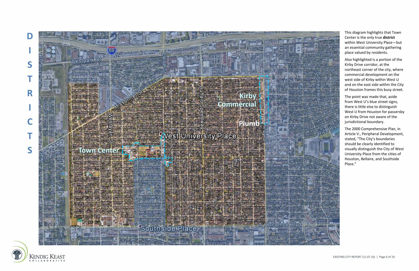
DISTRICTS Town Center
KirbyCommercial
Plumb
This diagram highlights that Town Center is the only true district within West University Place—but an essential community gathering place valued by residents.
Also highlighted is a portion of the Kirby Drive corridor, at the northeast corner of the city, where commercial development on the west side of Kirby within West U and on the east side within the City of Houston frames this busy street.
The point was made that, aside from West U’s blue street signs, there is little else to distinguish West U from Houston for passersby on Kirby Drive not aware of the jurisdictional boundary.
The 2000 Comprehensive Plan, in Article V., Peripheral Development, stated, “The City’s boundaries should be clearly identified to visually distinguish the City of West University Place from the cities of Houston, Bellaire, and Southside Place.”

EXISTING CITY REPORT (11.07.16) | Page 7 of 19
PATHS
Rice Blvd
University Blvd
Aude
n
Colle
geW
esla
yan
Kirb
y Dr
Wak
efor
est
Buffa
lo S
pdw
y
Edlo
e
Wes
t Poi
nt
Bissonnet St
Bellaire Blvd W Holcombe Blvd
The aerial image underlying this diagram highlights that West University Place residents experience both the benefits and downsides of a community with a classic “gridiron” street pattern.
On the one hand, a grid system helps to disperse traffic and provides many options—or paths—for moving about the community and reaching destinations.
However, this pattern also provides numerous links to the local street network at West U’s edges, which fosters some amount of cut-through traffic and contributes to residents’ security and crime concerns.
Three major arterials are at West U’s edges and provide pathways to other central Houston destinations: (1) Bissonnet Street on the north, (2) Kirby Drive on the east, and (3) Bellaire/W. Holcombe Boulevard on the south.
Weslayan Street and especially Buffalo Speedway provide paths for north-south traffic within and through the community.
Rice and University boulevards are the most significant east-west paths within the city, particularly between Town Center and the Rice Village area to the east. Various other streets can be highlighted as both internal paths and potential magnets for cut-through traffic, but West Point, College, Auden and Wakeforest are highlighted on the diagram.

EXISTING CITY REPORT (11.07.16) | Page 8 of 19
EDGES
Wes
laya
n
Kirb
y Dr
Buffa
lo S
pdw
y
Bissonnet St
Bellaire Blvd W Holcombe Blvd
RR /
Util
ity C
orrid
or
Poor
Far
m D
itch
Lot L
ines
Ac
adem
y
This diagram highlights physical features that, in some cases, create edges which reinforce West U’s jurisdictional limits but, in other cases, establish edges within the community.
The external edges include: The major streets highlighted as
outbound and inbound paths on the previous diagram (Bissonnet, Kirby and Bellaire/Holcombe).
The railroad and utility corridor on the west side.
The southern portion of Poor Farm Ditch that is the shared jurisdictional boundary with Southside Place.
Lot lines to the west of Auden Street, south of Town Center, that are on the jurisdictional boundary with Southside Place (rear lot lines in Southside and side lot lines in West U).
Academy Street north of Bissonnet is another external edge as homes along the west side in West U are in close proximity to the rear of the large Weslayan Plaza retail center.
Buffalo Speedway and Weslayan Street are internal edges due to the traffic volumes they carry.
Green arrows indicate locations where edges are overcome to some extent, such as where: Both West U and Houston have
single-family homes at the top of the West U “chimney” and across Kirby north of Holcombe.
Three ped/bike bridges provide links over Poor Farm Ditch.

EXISTING CITY REPORT (11.07.16) | Page 9 of 19
With regard to paths, the illustration above shows 24-hour traffic counts at selected locations in and around West University Place as collected by the Texas Department of Transportation (newest available counts from 2012 at green symbol locations; counts collected by the City of Houston at blue symbol locations are not included as they were from 2006). It is hoped that future traffic count efforts will include locations along Buffalo Speedway given the volume of traffic it carries through the city. [SOURCE: Houston Regional Traffic Count Map, Houston-Galveston Area Council, http://ttihouston.tamu.edu/hgac/trafficcountmap/TrafficCountMap.html, accessed October 13, 2016.]
36,720
3,15017,520
11,740
3,690
13,330
12,650
32,070
21,680
31,8801,660
2,710
1,940
1,320
6,190
5,990
2,330 5,850

EXISTING CITY REPORT (11.07.16) | Page 10 of 19
With regard to edges, the City’s official map of zoning districts illustrates the various district boundary locations where other types of land use abut single-family residential neighborhoods (e.g., blue commercial areas relative to light yellow and tan residential areas), as well as where differing intensities of residential use are near one another (e.g., peripheral districts other than light yellow and blue that are near Bissonnet on the north, Kirby on the east, and West Holcombe on the south). Red dashed lines were added in two locations to: (1) highlight the overall scope of the Town Center area (including educational and civic uses and places of worship), and (2) to indicate where single-family home lots abut the Recreation Center site at the city’s southwest corner. The zoning map may be viewed and explored in more detail via the Planning Division page on the City’s website. [SOURCE: City of West University Place, http://westutx.gov/DocumentCenter/View/638, accessed October 13, 2016.]
Key Numbers for West University Place
15,400 The estimated population of West University Place in 2015. This number is based on an average of population estimates from three sources: (1) the U.S. Census Bureau, (2) the Texas Demographic Center, where the State Demographer is based (at the University of Texas at San Antonio), and (3) the Houston-Galveston Area Council (H-GAC), the regional planning agency for the Houston metropolitan area. The individual estimates are shown below in Figure 1, Population Estimates, 2000-2015, along with the Census year population counts for 2000 and 2010.

EXISTING CITY REPORT (11.07.16) | Page 11 of 19
FIGURE 1: Population Estimates, 2000-2015
SOURCES: Regional Growth Forecast: 2015-2040, Houston-Galveston Area Council, May 2016. Texas Demographic Center (University of Texas at San Antonio), Population Estimates and Projections Program (May 2016 release). Annual Estimates of the Resident Population: April 1, 2010 to July 1, 2015 (May 2016 release). U.S. Census Bureau, Population Division.
42.4 The median age of West University Place residents in 2015. This is notably higher than the statewide median age of 33.9 years and the national median of 37.4 years. The community’s median age as of Census 2000 was 39.3 years. As of 2015, the share of the population age 19 or younger was 30.9 percent, which was little changed from 31.2 percent in 2000. However, the senior population age 65 or older had increased from 7.6 percent of the local population in 2000 to 11 percent in 2015. Across all of Harris County, as of 2015, the population age 19 or younger was nearly identical to West University Place at 30.3 percent. However, the senior population age 65 or older countywide was somewhat lower at 8.7 percent, relative to 11 percent locally.
SOURCE: U.S. Census Bureau, 2010-2014 American Community Survey 5-Year Estimates.
8.4% The share of Asian residents in West University Place as of 2015. This is the most notable change in racial composition since 2000, when the Asian share was 4.7 percent. The White population share has decreased from 92.4 percent in 2000 to 87.5 percent in 2015, and all other categories remain roughly the same. Additionally, the share of residents who identify themselves as being of Hispanic or Latino origin was 5.9 percent as of 2015. Growth in this population segment has been significant in recent decades in many parts of the nation and across Texas, where the Hispanic or Latino origin percentage was 38.2 percent as of 2015. Shown below in Figure 2, Race Composition of Population, 2010-2014, is the broader racial composition in West University Place over this recent five-year period (persons who identify as being of Hispanic or Latino origin may fall into one or more racial categories).
SOURCE: U.S. Census Bureau, 2010-2014 American Community Survey 5-Year Estimates.
15,741
15,730
14,739
14,787
14,211
13,000 13,500 14,000 14,500 15,000 15,500 16,000
US Census Bureau (July 2015)
Texas Demographic Center (January 2015)
Houston-Galveston Area Council (2015)
Census 2010 (April 2010)
Census 2000 (April 2000)

EXISTING CITY REPORT (11.07.16) | Page 12 of 19
FIGURE 2: Race Composition of Population, 2010-2014
$6,185,974,556 The total appraised value of all property in West University Place in 2016. The City’s Year 2000 budget document stated that total assessed value was $1.73 billion at that time, up from $1.57 billion in 1999. While inflation has to be factored in, the newest figure above the $6 billion mark was cited by various community leaders and residents as a key indicator of the value that continues to accrue in the city from new and renovated residential properties, as well as from other commercial and civic investments.
SOURCE: Finance Department, City of West University Place.
Other Essential Statistics for West University Place
Compiled below in Table 1, Community Indicators for West University Place Relative to Harris County, are other numbers that capture the unique nature of the community and its residents, especially when compared to the same indicators for all of Harris County.
TABLE 1: Community Indicators for West University Place Relative to Harris County
West University Place Harris County Mean Travel Time to Work = 18.1 minutes 27.7 minutes
Work at Home = 7% 3.2%
Employed in Management, Business, Science and Arts Occupations = 76.9%
34.5%
Median Household Income = $207,429 $53,822
High School Graduate or Higher = 99.1% Bachelor’s Degree or Higher = 88% Graduate or Professional Degree = 50.2%
79.1% 29% 10.3%
White, 87.5%
Black or African American, 0.8%
American Indian or Alaska Native, 0.2% Asian,
8.4%
Some Other Race, 0.9%
Two or More Races, 2.2%

EXISTING CITY REPORT (11.07.16) | Page 13 of 19
West University Place Harris County Dwellings Built Since 1980 = 61% Dwellings Built Before 1950 = 32.2%
52.7% 14.6%
Single-Family Detached Dwellings = 94.5% of all dwellings
57.4%
Owner- versus Renter-Occupied Dwellings = 87.5%
55.7%
Average Household Size in Owner-Occupied Dwellings = 2.84
3.07
Median Value of Owner-Occupied Dwellings = $815,700 *
* 82.3% valued at $500,000 or higher. 8.1% valued at less than $300,000.
$133,400
Moved Into Dwelling Since 2000 = 59.2% 75.8%
Dwelling Units with 3 or More Vehicles = 24.1%
17.2%
SOURCE: U.S. Census Bureau, 2010-2014 American Community Survey 5-Year Estimates.

EXISTING CITY REPORT (11.07.16) | Page 14 of 19
Key Opportunities and Challenges
From the means of leadership and community input to date cited at the beginning of this report, itemized below are the community planning topics mentioned most often through these discussions. The table also captures associated opportunities and challenges expressed for each item.
Topic Opportunities Challenges Town Center (TC) › Still the best opportunity—and
venue—for maintaining a “small town atmosphere” in West U (and those who enjoy the feel and vibrancy of the area even when it is busy).
› Those who do prefer to have some small-scale, community-oriented and contemporary restaurants and shops available within the city and accessible by bike or on foot—with appropriate limits for residential protection and quality that matches West U’s residential quality.
› Those who see the Edloe scenario as the best opportunity to leverage walkability in West U and apply the City’s zoning “to manage reasonable redevelopment at an appropriate scale” amid homes—“could see a farmers market there with our demographics, and a small parking structure at one end or in the middle” to overcome the parking issue.
› Those who call for a “balancing of TC pressures” and support for businesses and places of worship that are valuable parts of the community and need to upgrade their structures and properties.
› Potential to address housing needs of residents in their senior years in the TC area if the economics work (“age-in-place” opportunity versus having to leave city) —“development community would love to do senior housing in West U as they have nearby,” but also some concern if senior housing is too dense, rental versus ownership, and if it adds to parking pressures.
› Those who value West U Elementary, sports activities and civic/recreational facilities but do not like commercial in the TC mix (and are willing to drive outside the city for most shopping needs, and do not see it as a tax base need as in other cities).
› Those who prefer a smaller footprint for the Edloe commercial area (and other areas) than exists now—or no commercial at all through a phased transition to low-density residential or park use over time.
› Those who do not want to attract more non-residents into the community (to restaurants whether high-end or fast food, shopping, places of worship, etc.)—“if you make it too fancy ...”
› Those concerned about an aging and potentially no longer viable commercial area in the center of the community, which could lead to vacancy and/or blight in the years ahead (only certain buildings/ properties upgraded to date)—“what would you put there, or zone it for, instead?”
› Those who see church growth as a particular challenge for West U if growth means residential encroachment, and who want to see public process and church-community interaction when difficult proposals have to be decided on.
› Differing perceptions of TC traffic and parking “problems,” their sources, and best and viable ways to resolve them.

EXISTING CITY REPORT (11.07.16) | Page 15 of 19
› Suggestion of using more of TC footprint for West U Elementary expansion given its popularity and limited capacity—but warning by others that sports fields are sacrosanct and need to maintain green space in TC.
Peripheral Commercial Development
› No voices speaking against the current Comprehensive Plan policy of prohibiting any expansion beyond current areas of commercial use (especially along Kirby Drive), although some question whether residential use fronting on Kirby still makes sense.
› Clear resident support for zoning protections that limit impact of commercial uses on nearby residential (e.g., driveway location, adequate parking, screening, litter control), although desire to see better definition of allowed commercial uses.
› Recognition that ongoing improvements to residential properties “will take care of itself,” while there is more opportunity to grow the tax base through upgrades to nonresidential properties, which would fund better public services and capital projects.
› Concerns about any commercial renovations or upgrades that would amount to intensification of the use on the same site—“the challenge of making it new again without making it bigger.”
› But also concerns about “semi-derelict” commercial properties in some edge locations around West U (and difficulty of getting variances needed for feasible renovation)—“Want commercially-zoned property to be developed and competitive … want them all to be successful including Town Center.”
› Those who view it as a matter of land value and economics and/or for the market to determine (has to make financial sense for the business owner to upgrade or the property owner to redevelop the site, as well as to stay in business at current location in the meantime).
› Need to maintain sight visibility for drivers in all cases, including on older sites that have not redeveloped.
Residential Protection and Zoning Policies
› Those who prefer that West U remain and stand apart as “the only truly single-family residential community in central Houston.”
› Potential for somewhat lesser density even in single-family detached residential areas when multiple lots are purchased and combined for more yard area.
› Those who prefer no further housing development other than detached single-family residential and would like to see even some current townhome areas converted to single-family homes where possible.
› Perceptions by some that zoning enforcement could be stepped up.
› Concerns about home maintenance, especially where senior residents live in older homes, which goes beyond zoning and leaves some wanting ways to help seniors who have lived in West U a long time.

EXISTING CITY REPORT (11.07.16) | Page 16 of 19
Gradual Loss of Original Housing Stock
› Opportunities to do more through zoning and historic/landmark preservation tools as other cities and parts of the country with older housing do.
› Opportunity for more open/green space from properties with older homes that are not worth maintaining (as owners pass away).
› Those who cite physical factors (proliferation of “McMansions” with less architectural character and variation, more and higher privacy fences than in past, loss of tree cover) as contributing to a reduced sense of community and neighborhood compared to earlier years living in West U.
› Those who view it as a matter of land value and economics, and/or for the market to determine.
› Those who see it as a worthy goal, but not practical (too difficult for builders to do rehabilitation, too expensive a proposition for younger/older people who would benefit from a small home size).
› Those concerned about over-regulating and driving people away from West U (“the character is from the people now versus the charm of older homes”).
› Those who believe well-maintained smaller homes add to the character of the city but are concerned by inadequate maintenance of some older homes.
Traffic and Safety › Potential installation of high-visibility (i.e., solid painted, flashing light) crosswalks at key points along busy Buffalo Speedway, especially at or near Sunset Boulevard for safer navigation to/from Wier Park.
› Potential installation of a fourth bicycle/pedestrian bridge across Poor Farm Ditch, this one south of Town Center to provide a link between West U and Southside Place.
› Those who want West U to continue to appear and project itself as an open community rather than “walled” or “gated,” and with recognition that street closures and traffic calming measures too often just shift speeding and traffic problems to another location.
› Opportunity for more public education on safe walking/biking practices and risk reduction, as well as better homebuyer notification of traffic and parking realities in some areas of West U.
› Opportunities to enhance walking and biking even more in West U and get people outdoors.
› Those concerned about increasing traffic in and around the community, but recognition by others of general traffic volume and congestion increases with ongoing population growth and development across Houston.
› Those concerned about cut-through traffic, especially by motorists wanting to avoid congestion on Weslayan and Buffalo Speedway, and the extent of West U streets easily accessible to non-resident traffic—to the point of considering street closures or traffic diverters.
› Those not overly concerned about traffic issues but wanting to ensure that emergency vehicles can reach their destinations promptly.
› Those concerned about additional traffic generated by the student headcount at West U Elementary (with later confirmation that the school is limited to five temporary classroom buildings since 2013, for a period of five years, with review by the City’s Zoning Board of Adjustment and Building Standards Commission).

EXISTING CITY REPORT (11.07.16) | Page 17 of 19
› Comments about residents who choose not to use sidewalks and enjoy walking in streets as part of “small town feel.”
On-Street Parking › Suggestions to explore methods used in Southside Place and other cities to restrict or clear curb parking periodically (e.g., for street cleaning, trash/recycling collection, etc.).
› Recognition by some of the “mixed blessing” of on-street parking for its traffic calming benefit—unless the street is too narrow to begin with.
› Narrowness of some City streets. › Partly due to lifestyle changes—
more vehicles per household today relative to years past, and also bigger vehicles, plus more delivery vehicles with growth of online retailing.
› More vehicles parked on the street when homeowners use their garage space for other purposes.
› Lack of consensus during previous City attempts to craft potential solutions.
Storm Water Management (beyond certain areas with greater issues)
› Opportunities to incorporate “green infrastructure” and Low Impact Development (LID) techniques into future improvements and management methods.
› Mention of periodic street flooding and the lack of improvements to Poor Farm Ditch relative to drainage improvements seen in the City of Houston. But recognition by others that local drainage depends on downstream conveyances and ultimate receiving waters (i.e., Brays Bayou) that are overloaded during major storm events in the area.
Library › No voices speaking against the value of a local community library—need more community input on the long-term direction for it.
› Opportunity for “a much better library” in a better building to suit today’s technology and needs, including the potential for a redeveloped facility on the same site that houses both the library and community center functions without disrupting nearby residential properties.
› Limited ground area for expansion, plus ever-present parking needs.
› Only partial City control as a public facility and service provided through cooperation with Harris County.
› Residents impressed with upgrades made to nearby City of Houston library branches and want the same.

EXISTING CITY REPORT (11.07.16) | Page 18 of 19
Crime and Security of Residents
› Strong agreement about wanting to see crime prevention and residential security remain a prime focus of City government in the years ahead.
› Differing opinions on how far to go with technological measures such as security cameras in public areas.
› West U residents enjoy the advantages of their location within central Houston, but West U is also relatively close to multiple freeways, is accessible to external vehicular traffic from many directions, and has distinct socioeconomic differences from some nearby areas of Houston.
More Intensive Development and Redevelopment in the Vicinity
› Those who prefer to “let Houston have the multi-family development” so West U can maintain its single-family residential focus.
› Recognition by some that various new or upgraded developments just outside the City are “Class A” products and contribute to area-wide property values versus having older properties and potential blight nearby.
› Even more value placed on maintaining a “small town feel” and sense of community in West U.
› Consensus that additional traffic in the area is a primary concern of more intensive land use in areas of Houston near West U.
› Concern about nearby areas at risk of further deterioration in southwest Houston.
Other topics or concerns mentioned less frequently, but of note, include:
Ongoing preservation of trees as an integral characteristic of West U, particularly with the continuing trend of larger homes on relatively small lots.
Ongoing maintenance and repair of City streets to protect and prolong the major capital investment made.
Needed street and sidewalk upgrades in remaining areas not on par with improvements made in most of the city.
Issues and needs addressed in more depth by two other specialized plans of the City:
(1) Parks and Open Space Master Plan (need for more park space on the east side of the community; considering support of a potential dog park within the unused Westpark right-of-way, between Wakeforest and Buffalo Speedway, which is outside of West U but closer than other dog park options for residents to use and enjoy).
(2) Facilities Master Plan (make best use of City-owned properties and configure and operate City facilities efficiently and cost-effectively, need more ground area to have flexibility for future).
The need to revisit the City’s current zoning districts, standards and definitions to ensure they are consistent with current and projected conditions in the community (e.g., to limit “heavy” commercial uses and “auto-intensive” uses).

EXISTING CITY REPORT (11.07.16) | Page 19 of 19
The potential for “wi fi” in public areas.
Opportunities for more public art in West U.
The need for recycling receptacles and not just trash cans at City parks.
The prospect of merging the cities of West University Place and Southside Place to gain economies of scale in public service provision and given similar property tax rates at present.