Embed Size (px)
Citation preview

COMPREHENSIVE LAND USE PLAN SANTA CLARA COUNTY
HELIPORTS
Adopted by SANTA CLARA COUNTY
AIRPORT LAND USE COMMISSION San Jose, California
October 28, 2015
Prepared by Walter B. Windus
Aviation Consultant 12681 Saratoga Creek Dr.
Saratoga, California (408) 255-1917
i
TABLE OF CONTENTS
1 INTRODUCTION AND BACKGROUND ..................................................................................... 1-1
1.1 PURPOSE AND SCOPE............................................................................................................. 1-1 1.2 LEGAL AUTHORITY................................................................................................................ 1-1 1.3 BACKGROUND AND HISTORY ............................................................................................. 1-2 1.4 CONTENTS OF THE LAND USE COMPATIBILITY PLAN.................................................. 1-2 1.5 TECHNICAL REFERENCE DOCUMENT ............................................................................... 1-2
2 HELIPORTS AND THEIR ENVIRONS ........................................................................................ 2-1
2.1 HELIPORT ROLES .................................................................................................................... 2-1 2.2 HELIPORT LAYOUT PLANS................................................................................................... 2-1
2.2.1 Future Heliport Facilities ..................................................................................................... 2-3 2.3 AVIATION ACTIVITY.............................................................................................................. 2-3
2.3.1 Based Helicopters ................................................................................................................ 2-3 2.3.2 Helicopter Operations.......................................................................................................... 2-3
2.4 HELIPORT ENVIRONS............................................................................................................. 2-3 3 LAND USE COMPATIBILITY GUIDELINES............................................................................. 3-1
3.1 OVERVIEW................................................................................................................................ 3-1 3.2 LAND USE COMPATIBILITY CRITERIA .............................................................................. 3-1 3.3 NOISE RESTRICTION AREA................................................................................................... 3-1
3.3.1 Noise Descriptors ................................................................................................................ 3-2 3.3.2 Land Use Compatibility Standards – California .................................................................. 3-3 3.3.3 Land Use Compatibility Standards – Santa Clara County ................................................... 3-3 3.3.4 Land Use Compatibility Standards – City of San Jose ........................................................ 3-3 3.3.5 Land Use Compatibility Standards – City of Santa Clara ................................................... 3-4 3.3.6 Land Use Compatibility Standards – City of Palo Alto....................................................... 3-4 3.3.7 Land Use Compatibility Standards – City of Gilroy............................................................ 3-4 3.3.8 Helicopter Operations.......................................................................................................... 3-5 3.3.9 CNEL & SEL Noise Exposure Contours............................................................................. 3-5 3.3.10 Impacts on Land Use ........................................................................................................... 3-6
3.4 HEIGHT RESTRICTION AREA................................................................................................ 3-6 3.4.1 Primary Surface ................................................................................................................... 3-6 3.4.2 Approach Surface ................................................................................................................ 3-6 3.4.3 Transitional Surface............................................................................................................. 3-6 3.4.4 Summary.............................................................................................................................. 3-7
3.5 SAFETY RESTRICTION AREA ............................................................................................... 3-7 3.5.1 FAA Safety Area ................................................................................................................. 3-7 3.5.2 Helipad Protection Zone ...................................................................................................... 3-8 3.5.3 Approach Safety Zone ......................................................................................................... 3-8 3.5.4 Sideline Safety Zone............................................................................................................ 3-8
3.6 OVERFLIGHT RESTRICTION AREA ..................................................................................... 3-8 3.7 HELIPORT INFLUENCE AREA............................................................................................... 3-8
ii

4 LAND USE COMPATIBILITY POLICIES................................................................................... 4-1
4.1 LAND USE PLANNING ISSUES.............................................................................................. 4-1 4.2 JURISDICTIONAL RESPONSIBILITIES................................................................................. 4-1
4.2.1 Santa Clara County Airport Land Use Commission............................................................ 4-1 4.2.2 Affected Local Agencies ..................................................................................................... 4-3 4.2.3 Heliport Owner/Operator Responsibilities .......................................................................... 4-4
4.3 COMPATIBILITY POLICIES.................................................................................................... 4-4 4.3.1 General Compatibility ......................................................................................................... 4-4 4.3.2 Noise Compatibility............................................................................................................. 4-5 4.3.3 Height Compatibility ........................................................................................................... 4-5 4.3.4 Tall Structure Compatibility ................................................................................................ 4-7 4.3.5 Safety Compatibility............................................................................................................ 4-7 4.3.6 Overflight ............................................................................................................................ 4-9 4.3.7 Reconstruction ..................................................................................................................... 4-9 4.3.8 Infill ................................................................................................................................... 4-10
5 IMPLEMENTATION....................................................................................................................... 5-1
5.1 CONSISTENCY WITH LOCAL PLANS AND ZONING......................................................... 5-1 5.2 LAND USE DESIGNATIONS ................................................................................................... 5-1
5.2.1 Heliport Overlay Zones ....................................................................................................... 5-1 5.2.2 Avigation Easements ........................................................................................................... 5-2 5.2.3 Buyer Awareness Measures................................................................................................. 5-3 5.2.4 Methods of Calculating Density and Building Occupancy.................................................. 5-4
6 BIBLIOGRAPHY.............................................................................................................................. 6-1 7 APPENDIX A..................................................................................................................................... 7-1 8 HELIPORT SPECIFIC DETAILS.................................................................................................. 8-1
8.1 Heliport Specific Land Use Compatibility Plan .......................................................................... 8-1 8.1.1 Data Template...................................................................................................................... 8-1 8.1.2 Parameters for heliport under consideration ........................................................................ 8-1 8.1.3 Figures to be developed ....................................................................................................... 8-1
iii
LIST OF TABLES
Table 3 - 1 Heliport Design Parameters ..................................................................................................... 3-8 Table 4 - 1 Noise Compatibility Policies.................................................................................................... 4-6 Table 4 - 2 Safety Zone Compatibility Polices........................................................................................... 4-8
iv

LIST OF FIGURES
Figure 1 Heliport Location Map ………………………………………………………….……………….2-4
v

1-1
Section 1
1 INTRODUCTION AND BACKGROUND
1.1 PURPOSE AND SCOPE
This Heliport Land Use Compatibility Plan (HLUCP) is intended to safeguard the general welfare of the inhabitants within the vicinity of heliports and the helicopter occupants. Heliports are airports that are used solely for the takeoff and landing of helicopters and are too small for fixed-wing aircraft operations. Some larger airports have areas designated for the operations of helicopters but land use plans for those heliports are included in the airport CLUPs and are not included in this HLUCP. This HLUCP is also intended to ensure that surrounding new land uses do not affect the Heliport’s continued operation. Specifically, the HLUCP seeks to protect the public from the adverse effects of helicopter noise, to ensure that people and facilities are not concentrated in areas susceptible to helicopter accidents, and to ensure that no structures or activities adversely affect navigable airspace. The implementation of this HLUCP is intended to prevent future incompatible development from encroaching on the Heliport and allow for its development in accordance with the current heliport master plan. Consistent with California Public Utilities Code (PUC) 21670 et seq., the purpose of this Heliport Land Use Compatibility Plan (HLUCP) is to serve as a policy reference document and thus adoption of this HLUCP does not require that the corresponding general plans for the cities within the County be updated to be consistent with this document, per Public Utilities Code 21676. This policy reference document establishes sizing standards and a standard methodology for adopting heliport specific HLUCP’s at a future date. These future location-specific HLUCP’s for existing heliports will include the establishment of a Heliport Influence Area (HIA) with safety, height and noise policies. Consistent with California Public Utilities Code section 21675, future HLUCP’s would only be established for public-use heliports and policies contained herein do not apply to private-use heliports. Each heliport covered by this HLUCP will have its specific elements included in the appendix under the heliport’s name. The aviation activity forecast for the heliport is to be updated to reflect the existing aviation activity and provide at least a 20-year forecast of helicopter activity at the heliport. The updated helicopter activity forecasts form the basis for preparation of helicopter noise contours. The Heliport Layout Plan and updated aviation activity forecast and available helicopter noise contours form the basis for preparation of the HLUCP. 1.2 LEGAL AUTHORITY
The Public Utilities Code of the State of California, Sections 21670 et seq. authorizes each county to establish an Airport Land Use Commission (ALUC) and defines its range of responsibilities, duties and powers. The Santa Clara County Airport Land Use Commission is composed of 7 members, two appointed by the Santa Clara County Board of Supervisors, two appointed by the Santa Clara County City Selection Committee, two appointed by a committee composed of the Aviation Director of San Jose International Airport and the Director of the County Roads and Airports Department and one appointed at large by the ALUC. Section 21675 allows the ALUC to formulate and maintain an airport land use compatibility plan (ALUCP) for the area surrounding each public-use airport within Santa Clara County. An ALUCP may also be developed for military airports and heliports at the discretion of the ALUC. (The ALUCP developed for heliports is called a HLUCP.) Caltrans Division of Aeronautics and Santa Clara County records show that the County has thirteen heliports not located on public use airports. Section 21675 also specifies that comprehensive land use plans will:
(a) provide for the orderly growth of each public airport and the area surrounding the airport within the jurisdiction of the commission, and will safeguard the general welfare of the inhabitants within the vicinity of the airport and the public in general. The

1-2
commission plan shall include and shall be based on a long-range master plan or an airport layout plan, as determined by the Division of Aeronautics of the Department of Transportation, that reflects the anticipated growth of the airport during at least the next 20 years. In formulating a land use plan, the commission may develop height restrictions on buildings, may specify use of land, and may determine building standards, including soundproofing adjacent to heliports, within the planning area. The comprehensive land use plan shall be reviewed as often as necessary in order to accomplish its purposes, but shall not be amended more than once in any calendar year.
1.3 BACKGROUND AND HISTORY
Legislation passed by the State of California in 1967 mandated the creation of an Airport Land Use Commission in each county that had an airport served by a scheduled airline or operated for use by the general public. In conformance with this legislation the Planning Policy Committee, an existing decision-making body with representation from the 5 cities associated with an airport and the County, was designated to be the Airport Land Use Commission (ALUC) for Santa Clara County by the Board of Supervisors and the Select Committee of Mayors. After certification by the California Secretary of State, the Airport Land Use Commission officially came into existence in Santa Clara County in January of 1971. Their first land use policy plan was adopted on June 28, 1973. 1.4 CONTENTS OF THE LAND USE COMPATIBILITY PLAN
The Heliport Land Use Compatibility Plan (HLUCP) contains several major elements: • The existing and planned-for facilities at the Heliport that are relevant to preparing the HLUCP; • Appropriate noise, height, and safety restriction policies and land use compatibility standards; • Specific findings of compatibility or incompatibility with respect to existing land uses, proposed
General Plan land uses, or existing zoning controls; and • Specific actions that need to be taken to make the County of Santa Clara and the cities’ General Plans,
Specific Plans, Master Plans and/or Zoning Ordinances consistent with the Heliport Land Use Compatibility Plan.
The HLUCP establishes a heliport land use planning area, referred to as the Heliport Influence Area (HIA), which sets the boundaries for application of ALUC Policy. The HLUCP contains the relevant policies for land use compatibility and specific findings of compatibility or incompatibility of land uses within the HIA. Of particular interest to the ALUC are areas "not already devoted to incompatible uses" and, more specifically, undeveloped lands within the HIA. The planning effort is focused on identifying these lands because the policies and standards of the plan are intended to control the compatibility of future development in these areas. The HLUCP is not intended to define allowable land use for a specific parcel of land, although the plan establishes development standards or restrictions that may limit or prohibit certain types of uses and structures on a parcel. The HLUCP is not retroactive with respect to existing incompatible land uses, but discusses actions to be taken when expansion, replacement or other significant changes are made to incompatible land uses. The HLUCP does not apply to property owned by the federal government but may be used as a planning guide for land use development. 1.5 TECHNICAL REFERENCE DOCUMENT
A separate Technical Reference Library is being maintained by the County of Santa Clara. The Technical Reference Library will contain the major reference documents associated with the land use compatibility planning criteria in this HLUCP. The documents will be available for review at Santa Clara County Planning Office.

2-1
Section 2
2 HELIPORTS AND THEIR ENVIRONS
2.1 HELIPORT ROLES
Heliports fall into several “use categories”, such as Commercial, Emergency Services and Personal use. This HLUCP will focus on Emergency Service heliports, although heliports of the other uses may be included at a later date if the need arises. Emergency Services heliports are typically privately owned and for the private use of their owners.
Pursuant to PUC 21662 and CCR 3533, Emergency Medical Services (EMS) heliports and Emergency Use (EU) heliports are exempt from State Heliport Permit requirements if they are “used, over any 12-month period, for no more than an average of 6 landings per month with a patient or patients on the helicopter...” CCR 3527 (g) (2). Public use and personal use heliports require local agency review and approval. There are 10 recognized emergency service heliports in Santa Clara County. They are: 1. Kaiser Hospital, Santa Clara, CA EMS 2. Good Samaritan Hospital, San Jose, CA EMS 3. Valley Medical Center, San Jose, CA EMS 4. Regional Medical Center, San Jose, CA EMS 5. Stanford Hospital, Palo Alto, CA EMS 6. Saint Louise Hospital, Gilroy, CA EMS 7. Lexington CDF, Los Gatos, CA EU 8. Lick Observatory CDF, Santa Clara County EU 9. Sheriff’s Metcalf Gun Range, San Jose, CA EU 10. Sweetwater Fire Station, Santa Clara County EU The location of these heliports with respect to nearby communities and other heliports is illustrated on Figure 1. The 5 personal use heliports in the county are: Almaden Vineyards, San Jose, CA Canyon Creek, Morgan Hill, CA Fleaport, San Jose, CA Google, Inc, Mountain View, CA McCandless Towers, Santa Clara, CA Heliports in general and especially emergency service heliports are not listed in the Federal Aviation Administration’s (FAA) National Plan of Integrated Airport Systems (NPIAS) (2015-2019) but are included in the California Aviation System Plan published by Caltrans, Aeronautics Program. 2.2 HELIPORT LAYOUT PLANS
The development of a HLUCP requires several types of information, one of which is a heliport layout plan (HLP). This is a drawing of the heliport helipad with its markings and the surrounding support environment. As an emergency service heliport, there is little advantage in having a FAA “approved” or Caltrans approved HLP. The FAA-approved HLP is primarily used by the FAA for FAA airport grants and by Caltrans for their Airport Improvement Program (AIP) grants for eligible construction and development projects. These grant funds are only available to publicly owned aviation facilities. The FAA may review a heliport HLP and “Accept” it rather than “Approve” it. Selected data about some of the existing heliport facilities in Santa Clara County and information about their planned development are presented in the appendix under the name of the heliport.


2-3
2.2.1 Future Heliport Facilities
Any planned future additions to the heliport facility are to be included in the HLP and documented in the appendix associated with the heliport. 2.3 AVIATION ACTIVITY
The noise impact of a heliport is a direct result of the number of helicopter operations at that heliport and the types of helicopters using the facility. Given this information, and some other factors such as flight paths and the distribution of flight operations throughout the day and night, computer models can generate a representation of the noise contours around a heliport. The generalized flight tracks for the heliport are to be shown in a figure in the appendix for the associated heliport. The noise contours created by the computer model reflect the data provided and entered into the program. Thus the activity data, both current and forecasted, needs to be as accurate as possible. As the HLUCP is a 20-year planning document, the stated base year aviation activity shall be reviewed, and updated aviation activity forecasts prepared for the next 20-year period. A summary of the existing and forecast aviation activity is presented in the appendix associated with the heliport. 2.3.1 Based Helicopters
The make and model of each helicopter likely to use the facility is to be listed in a table associated with the specific HLUCP in the appendix. These data are taken from the Heliport Master Plan if any, and/or discussions with the heliport management. 2.3.2 Helicopter Operations
The number of annual helicopter operations at the heliport is to be presented in a table in the appendix for the specific heliport HLUCP including any forecasted change over the 20-year planning period. Local Operations. No “local” operations are expected at the heliport since all operations are anticipated to be from another site with the helicopter departing after discharging or picking up its passengers at the heliport. Local operations are those helicopter flights operating in the heliport traffic pattern and those departing and returning without landing at another heliport. Itinerant Operations. Itinerant operations are conducted by helicopters that takeoff from one heliport and land at another heliport, or the reverse. They include the operations of helicopters to and from the heliport. 2.4 HELIPORT ENVIRONS
One of the figures associated with a specific HLUCP is to be a figure showing the current land use designations within the Heliport environs based on the current city and/or County General Plans. The predominant land uses in the Heliport environs are to be shown in the figure.

3-1
Section 3
3 LAND USE COMPATIBILITY GUIDELINES
3.1 OVERVIEW
Land use compatibility policies and standards are based on community values, sound technical knowledge, and acceptable analytical methods. These policies and compatibility criteria form the basis for evaluating existing land use compatibility and provide the foundation for the Santa Clara County Airport Land Use Commission (ALUC) policies. These standards focus on the three areas of ALUC responsibility including helicopter noise, the control of objects in navigable airspace, and the safety of persons on the ground and in the helicopter. These compatibility criteria are contained in relevant State and Federal statutes and regulations and are discussed in this section. Federal, State and other local agencies have developed and published guidelines for land use compatibility planning. Unfortunately, no civilian or military authority has established regulations or statutes that specify a single methodology for mitigating the incompatibilities between a heliport and its environs, nor have such incompatibilities been adequately defined. The enabling legislation for the Santa Clara County Airport Land Use Commission offers some guidance while directing the Commission to provide for the orderly growth of the heliports and the areas surrounding the heliports, and to safeguard the general welfare of the inhabitants within the vicinity of the heliports and the public in general. The legislation further enables the Commission to develop height restrictions on structures, to specify the use of land, to determine building standards, including noise insulation, and to assist local agencies in ensuring compatible land uses in the vicinity of the heliports to the extent that the land in the vicinity of the heliports is not already devoted to incompatible uses. The Commission is also empowered to coordinate planning at the State, regional and local levels so as to provide for the orderly development of air transportation, while at the same time protecting the public health, safety, and welfare. 3.2 LAND USE COMPATIBILITY CRITERIA
The principal source for heliport land use compatibility planning is the October 2011 California Airport Land Use Planning Handbook (2011 Handbook) published by the California Department of Transportation, Division of Aeronautics (Caltrans). The 2011 Handbook provides guidelines for formulating compatibility criteria and policies for preparing Heliport Land Use Compatibility Plans (HLUCPs). Noise and safety compatibility concepts and issues are presented, and copies of relevant legislation and examples of mitigation measures, such as model noise and avigation easements are included. The 2011 Handbook is available for review at: http://www.dot.ca.gov/hq/planning/aeronaut/documents/alucp/AirportLandUsePlanningHandbook.pdf and at the Santa Clara County Planning Department office. Note that a local agency is not precluded from establishing land use policies that are more restrictive than those described in this HLUCP. 3.3 NOISE RESTRICTION AREA
Helicopter noise can affect people in neighborhoods surrounding heliports. At certain levels, helicopter noise can interfere with sleep, conversation, or relaxation. It also may disrupt school and work activities. At even higher levels, helicopter noise may impact outdoor activities and if frequent enough, may begin to raise health concerns with respect to hearing loss and stress-related problems. However, hearing damage from helicopter noise may not be a problem for nearby neighbors because noise levels are simply not of sufficient intensity to cause such damage. An exception to this is the exposure a ground crew member receives during the handling of a helicopter on the helipad. Similarly, medical studies are inconclusive on a cause-and-effect relationship for non-auditory health concerns near heliports. A more general conclusion is that noise may have an additive effect for some people with anxieties, ulcers, and tension illness. The amount of annoyance that helicopter noise creates among people living and working in the vicinity of a heliport varies on an individual basis. Studies show that a certain percentage of people will continue to be annoyed by helicopter noise at any given noise level, regardless of how low that helicopter noise may be. All levels of government share responsibility for addressing the heliport noise issue. The Federal government establishes noise standards for helicopters as published in Federal Aviation Regulations (FAR)

3-2
Part 36, Noise Standards: Aircraft Type and Airworthiness Certification, Appendix H & J, and conducts research on noise abatement techniques and noise compatibility. The preparation of a special heliport noise study under the provisions of FAR Part 150, Airport Noise Compatibility Planning, provides technical assistance to the public-use heliport operator in planning and implementing a noise compatibility program. The State of California also prescribes noise standards for all airports, including heliports, as defined in Title 21, Airport Noise Standards, of the California Code of Regulations, and sets noise insulation standards for residential structures as defined in Title 24, California Building Standards Code, of the California Building Standards Commission. The heliport operator may develop heliport noise control programs and enact operational restrictions to control and reduce noise levels in the community. Finally, local governments have the responsibility to limit the exposure of the population to excessive heliport noise levels through the land use planning and zoning process. 3.3.1 Noise Descriptors
To adequately address the airport noise issue, local governments need a standard way to measure and describe heliport noise and establish land use compatibility guidelines. The County of Santa Clara has identified DNL and CNEL as being equivalent measures of noise. Relative to aviation, it is common to use the Community Noise Equivalent Level (CNEL) for determining land use compatibility in the community environment. The Community Noise Equivalent Level (CNEL) descriptor is a method of averaging single-event noise levels over a typical 24-hour day and applying penalties to noise events occurring during the evening (7 p.m. to 10 p.m.) and night (10 p.m. to 7 a.m.) hours. CNEL is usually defined in terms of average annual conditions, so that the CNEL measured on a given day may be either less than or greater than the annual average. The State of California uses the CNEL descriptor to describe land use compatibility with respect to aircraft and helicopter noise exposures. CNEL is the noise descriptor standard defined in Title 21 of the California Code of Regulations, Airport Noise Standards, and the standard specified for evaluation of exterior and interior noise impacts in Title 24 of the California Building Standards Commission, California Building Standards Code. The CNEL is identified as one of two noise descriptors used in the preparation of a noise element of a general plan according to guidelines established by the Office of Noise Control, California Department of Health Services (now documented as General Plan Guidelines, Appendix A). The Federal Aviation Administration (FAA) recognizes the CNEL as essentially equivalent to the Yearly Day-Night Average Sound Level (DNL), which is the basis for FAA recommendations for land use compatibility with respect to aircraft noise described in FAR Part 150, Airport Noise Compatibility Planning. Averaging metrics like CNEL are not an adequate measure of the impact of noise from helicopter operations since most heliports have a small number of operations (arrivals and departures) over the analysis period. Thus the CNEL contours are very small and do not adequately represent the level of annoyance from operations at the heliport within the surrounding community. Helicopter noise has a character all its own. Although a portion of the noise emanates from the engines themselves, the uniqueness of helicopter noise is mostly due to the modulation of sound created by the relatively slow-turning of the main rotor as it hits the air around it. This sound modulation is known as blade slap. Blade slap is most pronounced during low-speed descents and high-speed cruise. To a listener on the ground, it is most audible as the helicopter approaches. Helicopters are also notable for creating perceived vibrations or rattle in structures. A better measure of community impact for helicopter operations is the single event noise metric, Sound Exposure Level (SEL) or Single Event Noise Exposure Level (SENEL). SENEL used in California is virtually identical to the SEL used by the Federal Aviation Administration and other federal agencies. The Sound Exposure Level (SEL) is a measure of the total “noisiness” of an event that takes duration into account. The Single Event Noise Exposure Level (SENEL) is the SEL for a defined noise threshold level. The SEL value represents the one-second long steady level that contains as much energy as the varying level over the full event. Lmax is the value in dBA of the maximum instantaneous noise level of the event.

3-3
The 1997 FICAN noise studies of aircraft noise events correlated to awakenings (see ANSI 12.9-2000/Part 6) were done using SEL noise metrics. Clearly the value for Lmax is lower than the value for SEL, unless the event is exceedingly short, less than 1 second (an explosion or gun shot for example). In aviation events, Lmax is about 10 dBA below the SEL value. Since this HLUCP deals with emergency service and public use heliports, the focus on helicopter noise impacts will be on those impacts occurring between 10 PM and 7 AM, normal sleeping hours, and schools, churches and meeting facilities. The decibel (dB) is the unit of measurement for the magnitude of a sound. A decibel is equal to the logarithm of the ratio of the intensity of the sound to the intensity of an arbitrarily chosen standard sound, specifically a sound just barely audible to an unimpaired human ear (e.g., 55, 60, 65, 70 and 75 dB). 3.3.2 Land Use Compatibility Standards – California
Land use compatibility guidelines for airport (including heliport) noise are included in the 2011 Handbook. Amendments to the law enacted in October 1994 mandate the use of these guidelines in the preparation of aviation land use plans. These guidelines were originally developed in 1983 after considering State Office of Noise Control (ONC), FAA, and U.S. Department of Housing and Urban Development (HUD) guidelines together with a review of available airport land use plans. Existing Federal and State laws were reviewed as part of the updated 2011 Handbook. The State ONC criteria established the 55 dB CNEL as a residential threshold value to distinguish normally acceptable from conditionally acceptable situations. The Caltrans guidelines for land use compatibility standards extend below the Federal 65 dB CNEL, as the Federal threshold does not sufficiently explain the annoyance area surrounding general aviation airports and heliports. The frequency of operations from some heliports, visibility of helicopters at low altitudes and typically lower background noise levels around many heliports are all believed to create a heightened awareness of helicopter activity and potential for annoyance outside of the 65 dB CNEL contour. At and above the 60 dB CNEL level, the California Building Code, Section 1208A.8.3 requires an acoustical analysis of proposed residential structures, other than detached single-family dwellings, to achieve an indoor noise level of 45 dB CNEL. The noise attenuating properties of existing types of construction were considered in setting state standards. Typical wood frame construction with drywall interiors provides noise reduction of between 15 and 20 dB. Thus, residential units exposed to outdoors noise in the range between 60 and 65 dB CNEL can be attenuated to achieve the 45 dB CNEL level indoors when built using normal standards of construction. The 2011 Handbook (see Appendix C therein) urges ALUCs to be conservative when establishing noise contours. 3.3.3 Land Use Compatibility Standards – Santa Clara County
In the Noise Element of the 1994 Santa Clara County General Plan, the County identified 55 dB DNL as the normally acceptable standard for residential uses. Above 55 dB DNL, residential uses are conditionally acceptable, however the noise exposure is great enough to be of some concern. 3.3.4 Land Use Compatibility Standards – City of San Jose
The Land Use Compatibility Guidelines for Community Noise in the Environmental Leadership chapter of the Envision San Jose 2040 General Plan Noise Policy EC-1.1, Interior Noise Levels, says: “The City’s standard for interior noise levels in residences, hotels, motels, residential care facilities and hospitals is 45 dBA DNL.” For Exterior Noise Levels, “The City’s acceptable exterior noise level objective is 60 dBA DNL for residential and most industrial land uses (Table EC-1). The acceptable exterior noise level objective is established for the City, except in the environs of the San Jose International Airport and the Downtown …..” The San Jose 2040 General Plan, Table EC-1 indicates that the maximum acceptable exterior noise exposure limit of 60 DNL for residential, hotels and motels, hospitals and residential care facilities,

3-4
schools, libraries, museums, meeting halls and churches is 60 dBA DNL. Specified land uses in noise areas above these exterior noise levels are permitted after an acoustical analysis of the amount of attenuation necessary to maintain an indoor level of DNL <= 45 dBA. Table EC-1 recommends a maximum exterior noise level of 50 DNL for Public and Quasi-Public uses, which include auditoriums, concert halls and amphitheaters. Additionally, the San Jose 2040 General Plan noise policies acknowledge the pre-existing noise context of the Airport. Specifically, noise policy numbers EC-1.9, EC-1.10, EC-1.11 and EC-1.12 in the General Plan state: Envision San Jose 2040 General Plan Noise Policy EC-1.9: “Require noise studies for land use proposals where known or suspected loud intermittent noise sources occur which may impact adjacent existing or planned land uses. For new residential development affected by noise from heavy rail, light rail, BART or other single-event noise sources, implement mitigation so that recurring maximum noise instantaneous noise levels do not exceed 50 dBA Lmax in bedrooms and 55 dBA Lmax in other rooms.” Note that the noise levels referenced in EC-1.9 above are approximately equivalent to a SEL of 60 dBA in bedrooms and 65 dBA in other rooms. With a 15 dBA attenuation due to typical home construction, this equates to an external noise level of 75 to 80 dBA SEL. Envision San Jose 2040 General Plan Noise Policy EC-1.10: “Monitor Federal legislative and administrative activity pertaining to aircraft noise for new possibilities for noise reducing modifications to aircraft engines beyond existing Stage 3 requirements. Encourage the use of quieter aircraft at the San Jose International Airport.” Envision San Jose 2040 General Plan Noise Policy EC-1.11: “Require safe and compatible land uses within the Mineta International Airport noise zone (defined by the 65 CNEL contour as set forth in state law) and encourage aircraft operating procedures that minimize noise.” Envision San Jose 2040 General Plan Noise Policy EC-1.12: “Encourage the Federal Aviation Administration to enforce current cruise altitudes that minimize the impact of aircraft noise on land use.” 3.3.5 Land Use Compatibility Standards – City of Santa Clara
The Noise Element in the Environmental Element of the City of Santa Clara 2000 – 2010 General Plan, Figure 5-G, indicates that for Residential and Public Educational facilities, an exterior noise level between 55 and 70 CNEL “requires design & insulation to reduce noise levels.” Above 70 CNEL, “Avoid land use except when entirely indoors and an interior noise level of 45 Ldn can be maintained.” (CNEL and Ldn are considered equivalent.) Noise Policy 23 says: “Within the San Jose Airport noise impact area, maintain residential neighborhoods as designated in the Land Use Element. Permit appropriate residential development in these neighborhoods subject to noise insulation.” Noise Policy 25 says: “Prohibit any significant new residential development in the adverse noise environment created by the San Jose International Airport (65 CNEL and over).” 3.3.6 Land Use Compatibility Standards – City of Palo Alto
In the Natural Environment element of the 1998 Palo Alto Comprehensive Plan, the City specifies a maximum interior noise level limit of 45 dB Ldn (equivalent to CNEL) and 50 dB SENL for single family residences and multiple family dwellings, and a maximum exterior noise level guideline of 60 Ldn for residences, hotels, motels, schools, libraries, museums, hospitals, meeting halls, personal care, and churches. Specified land uses in areas above these exterior noise levels are permitted after an acoustical analysis of the amount of attenuation necessary to maintain an indoor level of Ldn <=45 dB. Outdoor areas intended for residential recreational use with a noise level above 60 dB LDN are required to reduce noise levels as close to 60 dB Ldn as feasible through project design. 3.3.7 Land Use Compatibility Standards – City of Gilroy
The Noise element of the Community Resources and Potential Hazards Chapter of the June 2002 Gilroy General Plan sets the goal of “Protection of Gilroy residents from exposure to excessive noise and its effects through appropriate mitigation measures responsive land use planning, especially in regard to noise-sensitive land uses such as schools, hospitals and housing for seniors.” Figure 8 identifies the maximum

3-5
acceptable indoor residential noise level at 45 Ldn (dBA). The City of Gilroy Zoning Ordinance Section 41.31 discusses regulation of noise and its effects but Section 41.31(c) (1) grants an exemption for “Persons, equipment, vehicles, alarms or sirens utilized in essential activities necessary to preserve, protect or save lives or property from danger, loss or harm: …”. The City of Gilroy does not identify a specific SEL or SENEL noise limit. 3.3.8 Helicopter Operations
An analysis of annual helicopter operations and related noise levels for the Heliport is to be made to prepare CNEL noise contour exposure maps for the base year helicopter operations based on the existing and/or forecasted use. A second analysis is to be made to prepare SEL noise contour exposure maps for the base year helicopter operations based on the existing and/or forecasted use. These noise contours are assumed to be representative of the noise contours which may exist in the vicinity of the heliport and on which land use planning decisions should be made. The Federal Aviation Administration's (FAA) Integrated Noise Model (INM) Version 7.0 or later should be used to prepare CNEL and SEL noise exposure maps based on the FAA helicopter noise level database and heliport operational factors described for each heliport. The INM was developed by the FAA and represents the Federally sanctioned and preferred method for analyzing helicopter noise exposure. Version 7.0c is the currently available version of the INM, which incorporated an updated database of helicopter performance parameters and noise levels. Helicopter operational factors that can significantly affect overall noise levels as described by CNEL and SEL include the helicopter fleet mix, the number of daily operations and the time of day when helicopter operations occur. Trip length can also affect helicopter single-event noise levels. A helicopter that is making a local flight may carry less fuel and fewer passengers than that for a long flight and therefore make less noise on departure. The INM applies corrections to air carrier aircraft takeoff profiles to account for these differences, but makes no corrections to helicopter takeoff profiles. Descriptions of helicopter flight tracks must be developed for use in the INM through discussions with heliport management and review of the assumptions used for previous descriptions if any, of helicopter operations at the heliport. Based on these data, generalized flight tracks are to be prepared for use in the noise modeling process to describe areas with a concentration of helicopter overflights. It is recognized that variations in flight paths may occur at the heliport and that the tracks used for this analysis are a general representation of those flight tracks. 3.3.9 CNEL & SEL Noise Exposure Contours
The Integrated Noise Model (INM) Version 7.0c or later version should be used to prepare CNEL and SEL noise exposure contours for the heliport based on the helicopter noise level and operational factors described for the base year. Version 7.0c is the most recent version of the INM and incorporates an updated database of helicopter performance parameters and noise levels. User inputs to the INM include the following: • Heliport altitude and mean temperature • Helicopter flight track definition • Helicopter departure and approach profiles • Helicopter traffic volume and fleet mix • Flight track utilization by helicopter types The INM database includes helicopter performance parameters and noise level data for numerous commercial and general aviation (but not military) helicopter make and models. When the user specifies a particular helicopter make and model from the INM database, the program model automatically provides the necessary inputs concerning helicopter power settings, speed, departure profile, and noise levels. INM default values might be used for all helicopter types.

3-6
After the model had been prepared for the various helicopter classes, INM input files must be created containing the number of operations by helicopter class, time of day and flight track for annual average day helicopter operations and future operations. From these data, the INM produces lines of equal noise levels, i.e. noise contours. The location of these noise contours become less precise with distance from the helipad since helicopters do not follow each flight track exactly as defined in the model. However, they are accurate enough to indicate general areas of likely community response to noise generated by helicopter activity and serve as the basis for land use compatibility determinations. 3.3.10 Impacts on Land Use
The 60, 65, 70 and 75 dBA CNEL and 75, 80, 85, and 90 dBA SEL noise contours based on the helicopter operations in the base year are to be presented for the specific heliport under consideration. 3.4 HEIGHT RESTRICTION AREA
Height limitations in the vicinity of a heliport are required to protect the public safety, health, and welfare by ensuring that helicopter can safely fly in the airspace around the heliport. This protects both those in the helicopter and those on the surface who could be injured in the event of an accident. In addition, height limitations are required to protect the operational capability of heliports and the functions they serve. Federal Aviation Regulations (FAR) Part 77, Objects Affecting Navigable Airspace, establishes imaginary surfaces for helipads and runways as a means to identify objects that are obstructions to air navigation. Each surface is defined as a slope ratio or at a certain altitude above the Heliport elevation. FAA uses FAR Part 77 obstructions standards as elevations above which structures may constitute a safety hazard. Any penetrations of the FAR Part 77 surface are subject to review on a case-by-case basis by the FAA. The FAA evaluates the penetration based on the published flight patterns for the heliport, as they exist at that time. If a safety problem is found to exist, the FAA may issue a determination of a hazard to air navigation. The FAA does not have the authority to prevent the encroachment, however California law can prevent the encroachment if the FAA has made a determination of a hazard to air navigation. The local jurisdiction can establish and enforce height restrictions. The dimensions and slopes of the imaginary surfaces vary depending on the approach and departure paths to the helipad as shown on the Heliport Layout Plan. 3.4.1 Primary Surface
The heliport Primary Surface is defined as an area that coincides in size and shape with the designated take-off and landing area (TLOF) as shown in the Heliport Layout Plan. This surface is a horizontal plane at the elevation of the established heliport elevation. 3.4.2 Approach Surface
The Approach Surface is defined as a sloping surface centered on each of the approach/departure paths beginning at the outer edge of the heliport primary surface with the same width as the primary surface, and extending outward and upward for a horizontal distance of 4,000 feet where its width is 500 feet. The slope of the approach surface is 8 to 1 for civil heliports and 10 to 1 for military heliports. 3.4.3 Transitional Surface
The Transitional Surfaces are defined as sloping surfaces extending outward and upward from the lateral boundaries of the primary surface and from the approach surfaces at a slope of 2 to 1 for a distance of 250 feet measured horizontally from the centerline of the Primary Surface and Approach Surface centerlines.

3-7
3.4.4 Summary
Where imaginary surfaces overlap, such as in the case where the Transitional Surface penetrates and continues upward and outward from the Approach Surface, the lowest surface is used to determine whether or not an object would be an obstruction to air navigation. Any proposed new construction or expansion of existing structures that would penetrate any of the FAR Part 77 imaginary surfaces of the Heliport is considered an incompatible land use, unless either the FAA has determined that the proposed structure does not constitute a hazard to air navigation or the Caltrans Aeronautics Program has issued a permit allowing construction of the proposed structure. The FAA has established minimum standards for the determination of hazards or obstructions to aviation. The FAA permits local agencies such as the ALUC to establish more restrictive criteria for determining if the height of a structure creates a safety hazard to helicopter operations. A determination by the FAA or Caltrans that a project does not constitute a hazard to air navigation does not limit the ALUC from determining that a project may be inconsistent under the policies of this HLUCP. 3.5 SAFETY RESTRICTION AREA
Safety of people on the ground and in the air and the protection of property from heliport-related hazards are among the responsibilities of the Airport Land Use Commission. The 2011 Handbook presents guidelines for the establishment of heliport safety areas in addition to those established by the FAA. Heliport safety zones are established to minimize the number of people exposed to potential helicopter accidents in the vicinity of the Heliport by imposing density and use limitations within these zones. The safety zones are related to the design helicopter dimensions. In addition, the survivability of helicopter occupants in the event of an emergency landing has been shown to increase significantly if the helicopter is able to reach the ground under control of the pilot. As a result, open area requirements are established for the safety zones in addition to density and use requirements. The safety area is defined as a surface area extending beyond the FATO surface (see 3.5.1 below) by a distance equal to 1/3 of design helicopter main rotor maximum diameter, but not less than 10 feet. Exposure to potential helicopter accidents diminishes with distance from the helipad. The safety zones described below are in descending order of exposure to potential helicopter accidents, with the Safety area and Helipad Protection Zone (HPZ) having the highest exposure followed by the Approach Safety Zone (ASZ) with the Sideline Safety Zone (SSZ) having the lowest level of exposure. The safety zones defined for the Heliport are a composite based on the 2011 Handbook guidelines. The safety zones for the helipad are based on the helipad layout and the approach/departure paths. Safety zones are exclusive in their coverage, and do not overlay each other. Thus land in the SSZ is only in the SSZ, and is not also in the HPZ. The order of precedence is, from highest to lowest: HPZ, ASZ and SSZ. If a development project spans more than one safety zone, each part of the project must meet the requirements for the safety zone in which the land for that portion of the project is located. Thus a single building that extends over two safety zones may have differing height and density-of-use requirements for the two parts of the same physical structure. 3.5.1 FAA Safety Area
The FAA defines an area surrounding the Final Approach and Takeoff Area (FATO) as the Safety Area. The dimensions of this area vary depending on the designated use of the heliport but for Hospital and other emergency service heliports, the area extends beyond the FATO surface by 1/3 the rotor diameter of the Design Helicopter or 10 feet, whichever is greater.

3-8
Table 3 - 1
Heliport Design Parameters
Private Use1 Public Use GA2 Transport2 Hospital2 TLOF 1/3 rotor dia. or
10 feet if greater Rotor diameter of Design Helicopter
Rotor dia. or 50 ft if greater
Rotor dia. or 40 ft if greater
FATO >1.5 x LOA of Design Helicopter
>1.5 x LOA of Design Helicopter
2X rotor dia. or 100 ft by 200 ft if greater.
>1.5 x LOA of Design Helicopter
Safety Area 1/3 rotor dia. or 10 feet if greater
1/3 rotor dia. or 20 feet if greater
>30 ft. 1/3 rotor dia. or 10 feet if greater
Helipad Protection Zone (HPZ)
280 ft beyond FATO
280 ft beyond FATO
280 ft beyond FATO
280 ft beyond FATO
1 FAA AC 150/5390-2a 2 FAA AC 150/5390-2b Design Helicopter dimensions are in FAA AC 150/5390-2b, Appendix 1 3.5.2 Helipad Protection Zone
The function of the Helipad Protection Zone (HPZ) is to enhance the protection of people and property on the ground and helicopter occupants. The HPZ has the highest level of exposure to potential helicopter accidents. HPZs should be clear of all structures and activities. The HPZ is defined as a surface area extending 280 feet from the outer edge of the marked landing pad (TLOF) and has the same width as the surface projection of the Part 77.23 Approach Surface. It is centered on the associated approach/departure path. 3.5.3 Approach Safety Zone
The Approach Safety Zone (ASZ) has the second highest level of exposure to potential helicopter accidents. The Approach Safety zone(s) (APZ) are 1000 feet long extending from the outer edge of the HPZ, with the same dimensions as the surface projection of the Part 77.23 Approach Surface. 3.5.4 Sideline Safety Zone
The Sideline Safety Zone (SSZ) is an area extending 250 feet from the FATO edge (not TLOF). Helicopters do not normally over fly this area, except by the helicopter losing directional control on takeoff. The Sideline Safety Zone excludes the area of the HPZ and the APZ. 3.6 OVERFLIGHT RESTRICTION AREA
All areas within the Heliport Influence Area (HIA) should be regarded as potentially subject to helicopter overflights. Although sensitivity to helicopter overflights will vary from one person to another, overflight sensitivity is particularly important within residential land uses and certain agricultural uses. 3.7 HELIPORT INFLUENCE AREA
The Heliport Influence Area (HIA) is a composite of the areas surrounding the Heliport that are affected by noise, height, and safety considerations. The HIA is defined as a feature-based boundary around the Heliport within which all actions, regulations and permits must be evaluated by local agencies to determine how the Heliport Land Use Compatibility Plan policies may impact the proposed development. This evaluation is to determine that the development meets the conditions specified for height restrictions, and noise and safety protection to the public. [A.B. 332 (Stats. 2003) to be codified in Public Utilities Code 21674.7(b)]. The compatibility of land uses within the HIA should be preserved to the maximum extent feasible with particular emphasis on the preservation of existing agricultural and open space uses, if any. The conversion

3-9
of land from existing or planned agricultural, industrial, or commercial use to residential uses should be the subject of consideration of the potential impacts of helicopter overflights.

4-1
Section 4
4 LAND USE COMPATIBILITY POLICIES
4.1 LAND USE PLANNING ISSUES
The land use planning criteria for the individual land use planning issues applicable to the Heliport are discussed in Section 3.0. A figure is created for each heliport presenting a composite of the land use planning categories and the criteria that establishes the Heliport Influence Area (HIA). The Santa Clara County Airport Land Use Commission (ALUC) and the Heliport Land Use Compatibility Plan (HLUCP) for the Heliport address policies based on the following criteria: • Noise Restriction Area. The Noise Restriction Area is defined as the 60 dBA SEL contour, inside
which an acoustical analysis is required by the local agency with land use jurisdiction demonstrating how low-density, single-family, multi-family and mobile home dwelling units and schools have been designed to meet an interior noise level of 50 dBA SEL.
• Height Restriction Area. The Height Restriction Area is to protect the airspace around the Heliport.
The Height Restriction Area is defined as the lowest of the Approach Surfaces plus the Sideline as presented on the Part 77 Surfaces figure.
• Safety Restriction Area. The Safety Restriction Area is to provide land use safety with respect to
people and property on the ground and the occupants of helicopters. The safety zones applicable to the Heliport are defined in Section 3.5 and presented on the Safety Zone figure.
• Overflight Restriction Area. The Overflight Restriction Area is a composite of the areas surrounding
the Heliport that are areas affected by noise, height, and safety considerations. All areas within the HIA should be regarded as potentially subject to helicopter overflights as discussed in Section 3.6.
4.2 JURISDICTIONAL RESPONSIBILITIES
The policies set forth in this section contain criteria intended to prevent future conflicts between heliport operations and surrounding land uses. Implementation of these criteria requires action by the local jurisdictions that have control over the land uses in the Heliport Influence Area (HIA). The jurisdictional responsibilities for implementation of the HLUCP are described below. In addition, actions that are available to the local jurisdictions are also presented. Implementation of the HLUCP will be the responsibility of the County of Santa Clara and the associated city(ies) for those areas within the HIA under their jurisdiction. Note that Policies T-1 and T-2 extend countywide. The Santa Clara County Airport Land Use Commission (ALUC) will provide policy direction, advice, and technical assistance to the County and the City(ies) as needed to facilitate implementation of the HLUCP. 4.2.1 Santa Clara County Airport Land Use Commission
The Santa Clara County Airport Land Use Commission shall: • Adopt the heliport land use policies and the HIA boundary maps. The HLUCP and its planning
boundary maps shall, upon adoption, be subject to annual review by the ALUC and be updated as required.
Amendments to the HLUCP document are limited to no more than once per calendar year.
• Review the General Plan and applicable Specific Plans for the County of Santa Clara and the
associated city(ies) to determine if such plans and regulations are consistent with the policies of this HLUCP.

4-2
Until the ALUC has determined that the General Plans and Specific Plans of the County and cities are consistent, or until the County or associated city has overridden the ALUC's determination, all actions, regulations and permits within the HIA shall be referred to the ALUC for a consistency determination.
• Review all proposed amendments to the General Plans, Specific Plans, and zoning and building
regulations that may affect land use in the HIA. The ALUC shall determine if the proposed amendments are consistent or inconsistent with this HLUCP.
• Review proposed changes to the Heliport Master Plan or Heliport Layout Plan or modifications to the
helicopter flight tracks, new helicopter noise contours, or any other development that would alter the land use compatibility issues addressed in Section 3.0. The ALUC shall determine if the proposed changes are consistent with this HLUCP or if the HLUCP requires an amendment.
• Review the plans, regulations and other actions where there is a conflict with ALUC plans and
policies. A review of land use issues within the HIA relating to ALUC policies may be requested by any member of the ALUC, or by the owner/operator of the Heliport.
• Coordinate off-heliport land use planning efforts of the cities within the county, the County of Santa
Clara and Federal and State agencies concerned with heliport land use. • Gather and disseminate information relating to heliport land use and helicopter noise, height and safety
factors that may affect land use. 4.2.1.1 Review of Development Projects
Once the ALUC has determined that a local jurisdiction’s General Plan and applicable Specific Plans are consistent with the HLUCP (or the local jurisdiction has overruled the ALUC and made the required findings of consistency with the purposes stated in Public Utilities Code section 21670), to the extent that these are not mandated referrals the ALUC encourages the local jurisdictions to submit referrals to the ALUC for the following proposed developments: • Any project that requires use of the Infill policies or Reconstruction policy R-3 in order to be deemed
consistent with this HLUCP. • Proposed residential development, including land divisions, consisting of five or more dwelling units
or parcels within the HIA. • Major infrastructure development or improvements (e.g., water, sewer, roads) that would promote
urban development within the HIA. • Proposed land acquisition by any entity for the purpose of developing a school, hospital, nursing home,
library, outdoor theater, or other high-density or low-mobility uses within the HIA. • Any proposal anywhere in the County for construction or alteration of a structure (including antennas)
higher than 200 feet above ground level, to verify compliance with FAR 77.13 and ALUC policies. • Any proposed land use action by a city or County planning agencies involving a question of
compatibility with the Heliport’s activities. For example, creation of a landfill within the HIA would generally meet all height and density requirements, however the tendency of landfills to attract bird activity may create a safety hazard for heliport operations.
• Any project within the HIA that is voluntarily referred to the ALUC for review by the local agency.

4-3
4.2.1.2 Project Submittals
When review of a land use development proposal is required under this HLUCP, the referring agency shall provide the following information to the ALUC in addition to the information required by the city or County: • A map, drawn to an appropriate scale, showing the relationship of the project to the Heliport’s
boundaries and landing area, heliport safety zones, heliport CNEL and SEL noise contours and the FAA Part 77 Surfaces for the heliport.
• A detailed site plan showing ground elevations, location of structures, open spaces and the heights of
structures and landscaping.
• A description of permitted or proposed land uses and restrictions on the uses. • An indication of the potential or proposed number of dwelling units per acre for residential uses. • The maximum number of people potentially occupying the total site or portions of the site at any one
time. • Any project submitted for heliport land use compatibility review for reasons of height-limit issues shall
include a copy of the Federal Aviation Administration’s evaluation and reply to proponent’s notification to the FAA using FAA Form 7460-1, Notice of Proposed Construction or Alteration.
4.2.1.3 Review Process
The proposed actions referred to in Section 4.2.1.1 shall be referred to the ALUC at the earliest possible time but no later than the time allowed in the applicable statutes and regulations, in order that the ALUC's findings may be considered by the local agency prior to finalizing the proposed action. The ALUC must find a proposal either 1) consistent with the HLUCP or 2) inconsistent with the HLUCP. Additionally, the ALUC can provide recommendations for changes that would enhance the project's compatibility with the HLUCP or the ALUC can state under which conditions the proposal would be consistent. The ALUC must take action on a request for a consistency determination within 60 days of the referral. If the proponent desires to request a delay in determination, the proponent must withdraw the project from consideration and reapply at a later date. If the determination is not made within 60 days (or as extended by proponent’s request), the proposal shall be considered consistent with the HLUCP. The ALUC may, at the request of the local jurisdiction or interested party, provide an interpretation of any of the policies found in this HLUCP. 4.2.2 Affected Local Agencies
To bring their General Plan and Specific Plans into conformity with this HLUCP, the ALUC recommends that those local agencies with a hospital heliport consider the following: • Adopt the ALUC policies, and adopt the HIA boundary maps when available. • Incorporate the adopted ALUC policies, boundary maps, and land use recommendations into the local
agency’s General and/or Specific Plan and Zoning Ordinances. • Provide ongoing review of land uses within the HIA to ensure that land use changes are compatible
with ALUC policies and plans. The affected local agency shall work closely with ALUC staff to establish and carry out review coordination with the ALUC.
• Incorporate the HIA boundary maps into the local agency’s geographic information system (GIS).

4-4
4.2.2.1 Overrule Notification Process
The affected local agencies shall: • Notify the ALUC at least 45 days in advance, of their intent to overrule any ALUC non-consistency
determination including a copy of their proposed decision and specific findings.. • Notify the ALUC if and when the local agency overrules any ALUC non-consistency determinations. 4.2.3 Heliport Owner/Operator Responsibilities
To ensure that the ALUC is able to fulfill its statutory responsibilities, the heliport owner/operator should: • Notify the ALUC of operational or physical changes at the Heliport, such as helicopter flight tracks,
helipad configuration, structural development, relocation of facilities, and proposed new and/or updates to planning documents.
• Notify the ALUC of any changes that may affect Federal Aviation Regulations (FAR) Part 77 height
restriction surfaces or CNEL helicopter noise contours. • Provide CNEL and SEL noise contour data including the most recent actual data as well as forecasts
covering at least twenty years into the future. 4.3 COMPATIBILITY POLICIES
The compatibility of land uses in the vicinity of the Heliport will be evaluated for each of the potential land use impact categories in terms of the compatibility policies established for each category of concern. The graphic illustrations of each area of concern presented in this HLUCP are to be included in the evaluation. The following compatibility policies will be used for ALUC consistency review. 4.3.1 General Compatibility
4.3.1.1 Policies
G-1 In the case of conflicting policies, the most restrictive policy shall be applied. G-2 If a project falls into an area within two or more Heliport Influence Areas (HIA), the most restrictive conditions from each separate heliport shall apply to the project. G-3 The Heliport is exempt from the policies of this HLUCP for the development of projects on heliport property. G-4 Local jurisdictions should encourage the conversion of land uses that are currently incompatible with this HLUCP to uses that are compatible, where feasible. G-5 Where legally allowed, dedication of an avigation easement to the local agency shall be required to be offered as a condition of approval on all projects located within an Heliport Influence Area, other than reconstruction projects as defined in paragraph 4.3.7. All such easements shall be similar to that shown as Exhibit 1 in Appendix A. G-6 Any proposed uses that may cause a hazard to helicopters in flight are not permitted within the HIA. Such uses include electrical interference, high intensity light sources (stadium lights or scoreboards), attraction of birds (certain agricultural uses, sanitary landfills), and activities that may produce smoke, dust, or glare. G-7 All new exterior lighting within the HIA shall be designed so as to create no interference with helicopter operations. Such lighting shall be constructed and located so that only the intended area is illuminated and off-site glare is fully controlled. The lighting shall be arrayed in such a manner that it cannot be mistaken for heliport approach or takeoff and landing area lights by pilots.

4-5
4.3.2 Noise Compatibility
The objective of noise compatibility criteria is to minimize the number of people exposed to frequent and/or high levels of helicopter noise. Heliports associated with hospitals are exempt from these noise policies. 4.3.2.1 Policies
N-1 The Sound Exposure Level (SEL) method of representing noise levels shall be used to determine if a specific land use is consistent with the HLUCP. N-2 In addition to the other policies herein, the Noise Compatibility Guidelines presented in Table 4-1 shall be used to determine if a specific land use is consistent with this HLUCP. N-3 Noise impacts shall be evaluated according to the Helicopter Noise Contours associated with the heliport. N-4 No school, church, library, meeting hall or transient lodging construction shall be permitted within the 75 dBA SEL contour boundary unless it can be demonstrated that the resulting interior sound levels will be less than 55 dBA SEL and there are no outdoor patios or outdoor activity areas associated with the residential portion of a mixed use residential project of a multi unit residential project. (Sound wall noise mitigation measures are not effective in reducing noise generated by helicopters flying overhead.) N-5 All property owners within the 75 dBA SEL contour boundary who rent or lease their property for residential use shall include in their rental/lease agreement with the tenant, a statement advising that they (the tenants) are living within a high noise area and the exterior noise level is predicted to be greater than 75 dBA SEL in a manner that is consistent with current state law including AB2776 (2002). N-6 Residential construction will not be permitted in the area within the 75 dBA SEL contour boundary unless it can be demonstrated that the resulting interior sound level will be no greater than 55 dBA SEL. N-7 Noise level compatibility standards for other types of land uses shall be applied in the same manner as the above residential noise level criteria. Table 4-1 presents acceptable noise levels for other land uses in the vicinity of the Heliport. N-8 Sound Exposure Levels (SEL) from single helicopter overflights are to be considered when evaluating the compatibility of highly noise-sensitive land uses such as schools, libraries, outdoor theaters, and mobile homes. Single-event noise levels are especially important in the areas regularly overflown by helicopter, but which may not produce significant CNEL contours, such as the down-wind segment of the traffic pattern, and heliport entry and departure flight corridors. 4.3.3 Height Compatibility
The objective of height compatibility criteria is to avoid development of land uses, which, by posing hazards to flight, can increase the risk of an accident occurring. 4.3.3.1 Policies
H-1 Any structure or object that penetrates the Federal Aviation Regulations Part 77, Objects Affecting Navigable Airspace, (FAR Part 77) surfaces, as described in paragraph 3.4 and illustrated in Figure 6 for the associated Heliport, will be considered an incompatible land use. H-2 Any project that may exceed a FAR Part 77 surface must notify the Federal Aviation Administration (FAA) as required by FAR Part 77, Subpart B on FAA Form 7460-1, Notice of Proposed Construction or Alteration. (Notification to the FAA under FAR Part 77, Subpart B, is required even for certain proposed construction that does not exceed the height limits allowed by Subpart C of the FARs).

4-6
Table 4 - 1
NOISE COMPATIBILITY POLICIES
SEL LAND USE CATEGORY < 75 75-80 80-85 85-90 90-95 > 95
Residential – low density Single-family, duplex, mobile homes
*
**
****
****
****
****
Residential – multi-family, condominiums, townhouses
*
**
****
****
****
****
Transient lodging - motels, hotels * * ** **** **** ****
Schools, libraries, indoor religious assemblies, hospitals, nursing homes
*
***
****
****
****
****
Auditoriums, concert halls, amphitheaters * *** *** **** **** ****
Sports arena, outdoor spectator sports, parking * * * ** *** ****
Playgrounds, neighborhood parks * * *** **** **** ****
Golf courses, riding stables, water recreation, cemeteries
*
*
*
**
***
****
Office buildings, business commercial and professional, retail
*
*
**
***
****
****
Industrial, manufacturing, utilities, agriculture * * * *** *** ****
* Generally Acceptable Specified land use is satisfactory, based upon the assumption that any buildings involved are of normal conventional construction, without any special noise insulation requirements. Mobile homes may not be acceptable in these areas. Some outdoor activities might be adversely affected.
** Conditionally Acceptable New construction or development should be undertaken only after a detailed analysis of the noise reduction requirements is made and needed noise insulation features included in the design. Outdoor activities may be adversely affected. Residential: Conventional construction, but with closed windows and fresh air supply systems or air conditioning will normally suffice.
*** Generally Unacceptable New construction or development should be discouraged. If new construction or development does proceed, a detailed analysis of the noise reduction requirements must be made and needed noise insulation features included in the design. Outdoor activities are likely to be adversely affected.
**** Unacceptable New construction or development should not be undertaken.
Source: Based on General Plan Guidelines, Appendix C (2003), Figure 2, San Jose Envision 2040 and FICAN 1997

4-7
4.3.4 Tall Structure Compatibility
Structures of a height greater than 200 feet above ground level can be a special hazard to helicopters in flight. 4.3.4.1 Policies
T-1 The applicant for any proposed project anywhere in the County for construction or alteration of a structure (including antennas) higher than 200 feet above ground level shall submit to the FAA a completed copy of FAA Form 7460-1, Notice of Proposed Construction or Alteration. A copy of the submitted form shall be submitted to the Santa Clara County ALUC as well as a copy of the FAA’s response to this form. T-2 Any proposed project anywhere in the County for construction or alteration of a structure (including antennas) higher than 200 feet above ground level shall comply with FAR 77.13(a)(1) and shall be determined inconsistent if deemed to be a hazard by the FAA or if the ALUC determines that the project has any impact on normal helicopter operations or would increase the risk to helicopter operations. 4.3.5 Safety Compatibility
The objective of safety compatibility criteria is to minimize the risks associated with potential helicopter accidents. These include the safety of people on the ground and the safety of helicopter occupants. Land uses of particular concern are those in which the occupants have reduced effective mobility or are unable to respond to emergency situations. 4.3.5.1 Policies
S-1 These policies and the Safety Zone Compatibility Policies presented in Table 4-2 shall be used to determine if a specific land use is consistent with the HLUCP. Safety impacts shall be evaluated according to the specific Heliport Safety Zones. For emergency-use helipads, these safety zone policies are recommended guidelines. S-2 Schools, hospitals, nursing homes, and other uses in which the majority of occupants are children, elderly, and/or disabled shall be prohibited within the Helipad Protection Zones (HPZs), Approach Safety Zones (ASZs) and Sideline Safety Zones (SSZs). S-3 Amphitheaters, sports stadiums and other very high concentrations of people shall be prohibited within the Helipad Protection Zones (HPZs), Approach Safety Zones (ASZs) and Sideline Safety Zones (SSZs) presented in the heliport safety zone figure. S-4 Storage of fuel or other hazardous materials shall be prohibited in the Helipad Protection Zone. Above ground storage of fuel or other hazardous materials shall be prohibited in the Approach Safety Zone. Beyond these zones but in the Heliport Influence Area, storage of fuel or other hazardous materials not associated with helicopter use should be discouraged. S-5 In addition to the requirements of Table 4-2, open space requirements, for sites which can accommodate an open space component, shall be established at the general plan level for each safety zone where feasible as determined by the local jurisdiction, as individual parcels may be too small to accommodate the minimum-size open space requirement. To qualify as open space, an area must be free of buildings, and have minimum dimensions of at least 50 feet wide by 75 feet long along the normal direction of flight. The clustering of development and provision of contiguous landscaping and parking areas will be encouraged to increase the size of open space areas.

4-8
Table 4 - 2
SAFETY ZONE COMPATIBILITY POLICIES
Heliports
Safety Zone
Maximum Population Density
Open Space Requirements
Land Use
Helipad Protection Zone – HPZ
-0- (No people allowed)
100 percent (No structures
allowed)
Agricultural activities, roads, open low-landscaped areas. No trees, telephone poles or similar obstacles. Occasional short-term transient vehicle parking is permitted.
Approach Safety Zone –ASZ
Nonresidential, maximum 120 people per acre (includes open area and parking area required for the building’s occupants and one-half of the adjacent street area)
30 percent of Approach Safety Zone area within the Approach Surface boundaries as determined in the heliport land use application.
No residential. Nonresidential uses should be activities that attract relatively few people. No shopping centers, restaurants, theaters, meeting halls, stadiums, multi-story office buildings, labor-intensive manufacturing plants, educational facilities, day care facilities, hospitals, nursing homes or similar activities. No hazardous material facilities (gasoline stations, etc.).
Sideline Safety Zone - SSZ
Nonresidential, maximum 300 people per acre (includes open area and parking area required for the building’s occupants and one-half of the adjacent street area)
30 percent of gross area
Residential - if non-residential uses are not feasible, allow residential infill to existing density. No regional shopping centers, theaters, meeting halls, stadiums, schools, large day care centers, hospitals, nursing homes or similar activities. No above ground bulk fuel storage.
Source: Based on 2011 Airport Land Use Planning Handbook prepared by the California Department of Transportation, Division of Aeronautics

4-9
S-6 The principal means of reducing risks to people on the ground is to restrict land uses so as to limit the number of people who might gather in areas most susceptible to helicopter accidents. A method for determining the concentration of people for various land uses is presented in Section 5.0, Implementation. S-7 The following uses shall be prohibited in all Heliport Safety Zones:
• Any use which would direct a steady light or flashing light of red, white, green, or amber colors associated with heliport operations toward a helicopter engaged in an initial straight climb following takeoff or toward a helicopter engaged in a straight final approach toward a landing at a heliport, other than an FAA-approved navigational signal light or visual approach slope indicator.
• Any use that would cause sunlight to be reflected towards a helicopter engaged in an initial
straight climb following takeoff or towards a helicopter engaged in a straight final approach towards a landing at a heliport.
• Any use which would generate smoke or water vapor, or which would attract large concentrations
of birds, or which may otherwise negatively affect safe air navigation within the area.
• Any use which would generate electrical interference that may be detrimental to the operation of helicopter and/or helicopter instrumentation, communication or navigation equipment.
S-8 Buildings that would interfere with a helicopter descending to an emergency landing in a safety zone open area are not permitted. S-9 In unique cases an exception can be granted, at the discretion of the ALUC, on the basis of mitigation measures proposed by the applicant which would result in the final project improving the overall safety in the safety zones in comparison to the situation existing prior to the project. An example of such a possible mitigation is the removal of existing incompatible structures in exchange for constructing less incompatible structures. The following conditions must be met for this variance to be granted:
a. There must be a clear, demonstrable net improvement in safety.
b. The mitigation must provide a permanent improvement in safety. For instance, in the example above, the removed structures could not be replaced by other structures at a later date.
4.3.6 Overflight
The objective of the overflight compatibility criteria is to assist those persons who are highly annoyed by overflights or have an above-average sensitivity to helicopter overflights to avoid living in locations where these impacts may occur. 4.3.6.1 Policies
O-1 All new projects within the HIA that are subject to discretionary review and approval shall be required to dedicate an avigation easement to the local agency. The avigation easement shall be similar to that shown as Exhibit 1 in Appendix A. (In September of 2002 Assembly Bill AB2776 was signed into law and became effective on January 1, 2004. This statute requires that as part of the real estate transfer process, the purchaser be informed if the property is in a Heliport Influence Area and if so, the purchaser is to be informed of the potential impacts resulting from the associated heliport.) 4.3.7 Reconstruction
Reconstruction as used in this HLUCP is the rebuilding of a legally established structure in any of the safety zones, to its original conditions (typically due to a fire or earthquake damage or destruction). “Original conditions” means the same or lesser footprint, height and intensity of use. Reconstruction projects may be approved under the following policies:

4-10
4.3.7.1 Policies
R-1 Reconstruction projects that are not subject to a previous avigation easement shall not be required to provide an avigation easement as a condition for approval. R-2 Residential reconstruction projects must include noise insulation to assure interior noise levels of less than 50 dBA SEL. R-3 An application for reconstruction increasing the structure’s internal square footage, footprint square footage, height, and/or intensity of use may be approved if the local agency determines that such increase will have no adverse impact beyond that which existed with the original structure. However, a project approved under this policy shall require the property owner to offer and the local agency shall accept an avigation easement, similar to Exhibit 1 in the Appendix. 4.3.8 Infill
Infill as used in this HLUCP is defined as the development of vacant or underutilized residential properties located in a safety zone, of less than 0.25 acres in size, in areas that are already substantially developed with uses not ordinarily permitted by the HLUCP compatibility criteria. In some circumstances, infill projects may be acceptable if the following criteria are met. Redevelopment is defined as land that previously contained a building that was removed or demolished with the intent of replacing the building with a new building for a different use. Redevelopment is not considered Infill. 4.3.8.1 Policies
I-1 Infill projects must comply with paragraph 4.3.5 and Table 4-2 of this HLUCP with the exception of the land use density requirements. I-2 Infill projects may be approved if all of the following conditions are met:
a) The total contiguous undeveloped land area at this location is less than 0.25 acres in size. Note that this means the total contiguous undeveloped land area, not just the land area being proposed for development. Lots larger than 0.25 acres shall not be considered for infill.
b) The site is already surrounded on three sides and a street, or two sides and two streets, by the same
land use as that being proposed.
c) The ALUC determines that the project will create no adverse safety impacts beyond those that already exist due to the existing incompatible land uses.
d) The property owner shall offer and the local agency shall accept an avigation easement similar to
Exhibit 1 in the Appendix.

5-1
Section 5
5 IMPLEMENTATION
5.1 CONSISTENCY WITH LOCAL PLANS AND ZONING
The California State Aeronautics Act (Public Utilities Code: Division 9, Part 1, Chapter 4, Article 3.5, Section 21670 et seq) places the responsibility for implementing and enforcing this Heliport Land Use Compatibility Plan (HLUCP) on the local governmental agencies responsible for land use planning within each heliport’s Heliport Influence Area (HIA). Once the ALUC has adopted a revised (or new) HLUCP, and transmitted that HLUCP to an affected local agency that local agency is mandated to incorporate the HLUCP’s provisions into its General and/or Specific Plan(s) within 180 days (Government Code 65302.3(b)). Implicitly, the local agency is then encouraged to adopt zoning ordinance(s) that implement the policies of their General/Specific Plan(s). If a local agency decides not to incorporate the HLUCP policies verbatim in its General and/or Specific plans, it may overrule portions (or all of) the HLUCP if it finds that its General and/or Specific Plans are consistent with the State Aeronautics Act, PUC 21670 et seq. The overrule process requires a two-thirds vote of the local agency’s governing body, supported by specific findings which demonstrate that the plan(s) satisfy the purposes of the State Aeronautics Act (PUC 21670 et seq) and guidance of the state’s Airport Land Use Planning Handbook. During the amendment process and subsequent to adoption of revised General and/or Specific Plan(s) by a local agency, the ALUC is required to promptly review both the draft and final Plan(s) for a HLUCP consistency determination {PUC 21676}. 5.2 LAND USE DESIGNATIONS
The most fundamental means of assuring compatibility between a heliport and surrounding land uses is by the designation of appropriate land uses in local general plans, specific plans, and zoning ordinances. Even with the designation of appropriate land uses, the long-term maintenance of heliports and land use compatibility is often difficult to achieve. Land use designations can be limited in the degree of restrictiveness that can be applied. Overly restrictive land use regulations may raise constitutional questions to the taking of private property without just compensation. This is particularly applicable in areas near the helipad where such extreme restrictions may be appropriate. For this reason heliport owners/operators are encouraged to purchase an interest in the land containing the most restrictive safety zones in order to affect the purposes of this Plan. Land use designations for an area for different uses than already exist may encourage change in the long term, but it may not eliminate existing incompatible uses. Other actions such as fee simple acquisition may be necessary to bring about the changes. 5.2.1 Heliport Overlay Zones
One way of achieving aviation-oriented land use designations is adoption of an overlay or combining zone. An overlay zone supplements local land use designations by adding specific noise and, often more importantly, safety criteria (e.g., maximum number of people on the site, site design, and open space criteria, height restrictions, etc.) applicable to future development in the HIA. A heliport overlay zone has several important benefits. Most importantly, it permits the continued utilization of the majority of the design and use policies contained in the existing zones. At the same time, it provides a mechanism for implementation of restrictions and conditions that may apply to only a few types of land uses within a given land use category or zoning district. This avoids the need for a large number of discrete zoning districts. It also enables local jurisdictions to use the policies provided in the HLUCP, rather than through redefinition of existing zoning district descriptions.
The County and cities should consider the following for inclusion in the Heliport Overlay District Zone (Heliport Safety Overlay Zone): • Noise Insulation Standards - In areas that will potentially be impacted by noise, the Heliport Overlay
District Zone could be used to assure compliance with the State statutes regarding interior noise levels. The Overlay District Zone could specify the construction techniques necessary to meet the requirements.
• Height Limitations - Restrictions on the height of buildings, antennas, trees, and other objects near the
Heliport, as defined by Federal Aviation Regulations (FAR) Part 77, Subpart C, and regulated by the California Aeronautics Law, can be implemented as part of the Heliport Overlay District Zone.
• FAA Notification Requirements - The Heliport Overlay District Zone also can be used to assure that
project developers are informed about the need for compliance with the notification requirements of FAR Part 77. Subpart B of the regulations requires that the proponent of any project that exceeds a specified set of height criteria submit a FAA Form 7460-1 Notice of Proposed Construction or Alteration to the FAA prior to commencement of construction. The height criteria associated with this notification requirement are lower than those in FAR Part 77, Subpart C, which define airspace obstructions. The purpose of the notification is to determine if the proposed construction would constitute a potential hazard or obstruction to flight. Notification is not required for proposed structures that would be shielded by existing structures or by natural terrain of equal or greater height, where it is obvious that the proposal would not adversely affect air safety.
• Maximum Densities - The principal noise and safety compatibility standards in the HLUCP are
expressed in terms of dwelling units per acre for residential uses and people per acre for other land uses. These standards can either be included as is in the Heliport Overlay District Zone or used to modify the underlying land use designations. For residential land uses, the correlation between the compatibility criteria and land use designations is direct. For other land uses, the implications of the density limitations are not as clear. One step that can be taken by local governments is to establish a matrix indicating whether specific types of land uses are or are not compatible with each of the four compatibility zones. To be useful, the land use categories will need to be more detailed than typically provided by general plan or zoning ordinance land use designations.
• Open Space Requirements - HLUCP criteria regarding HIA open space suitable for emergency
helicopter landings can be implemented by the Heliport Overlay District Zone. These criteria are most effectively carried out by planning at the general or specific plan level, but may also need to be addressed in terms of development restrictions on large parcels.
5.2.2 Avigation Easements
Avigation easements are another type of land use control measure available to local jurisdictions. Historically, avigation easements have been used to establish height limitations, prevent other flight hazards, and prevent noise impacts. More recently, they have been used as a form of buyer awareness - the recording of an easement against a property ensures that prospective buyers of the property are informed about the Heliport impacts. (See the Appendix for a typical Avigation Easement). An avigation easement applies only to the specific property to which it is attached and it is binding on all subsequent owners of the property. Avigation easements can be obtained either by purchase or by required dedication. • Purchase - Acquisition of avigation easements for a monetary amount is usually done by the Heliport
owner, which may or may not be the same as the local land use jurisdiction. In most instances, the purchase of avigation easements is limited to property within Runway Protection Zones or elsewhere very close to the Heliport’s boundaries where some significant degree of restriction or impact is involved.
• Dedication - Required dedication of avigation easements is sometimes set as a condition for local jurisdiction approval of a proposed land use development, especially a residential development, in the
5-2

vicinity of a Heliport. Generally, when avigation easements are obtained in this manner, they are primarily intended to serve as a comprehensive and stringent form of a buyer awareness measure.
A standard avigation easement conveys the following property rights from the owner of the property to the holder of the easement: • Overflight - A right-of-way for free and unobstructed passage of helicopters through the airspace over
the property at any altitude above a surface specified in the easement (in accordance with Federal Aviation Regulations Part 77 and/or criteria for terminal instrument procedures).
• Impacts - A right to subject the property to noise, vibration, fumes, dust, and fuel particle emissions
associated with heliport and helicopter activity. • Height Limits - A right to prohibit the construction or growth of any structure, tree, or other object
that would penetrate the acquired airspace. • Access and Abatement - A right-of-entry onto the property, with appropriate advance notice, for the
purpose of removing, marking, or lighting any structure or other object that enters the acquired airspace.
• Other Restrictions - A right to prohibit electrical interference, glare, misleading light sources, visual
impairments, and other hazards to helicopters from being created on the property. Easements that convey only one or more of these rights are common. An easement containing only the first two rights is usually referred to as an overflight or noise easement. The latter three rights are often collectively called a height-limit or airspace easement. Overflight easements are useful in locations sufficiently distant from a heliport where height limits and other restrictions are not a concern. Height-limit easements have most frequently been obtained by purchase of properties close to a heliport where restrictions on the height of objects are necessary. Because height-limit easements do not include the overflight easement rights, there is little apparent advantage to obtaining them rather than a complete avigation easement. 5.2.3 Buyer Awareness Measures
Buyer awareness is an umbrella category for types of heliport/land use compatibility measures whose objective is to ensure that prospective buyers of property in the vicinity of a heliport are made aware of the heliport's existence and the impacts that the heliport activity has on surrounding land uses. Avigation easements are the most definitive form of a buyer awareness measure. Buyer awareness can also be successfully implemented through other types of programs. Two primary methods are deed notices and real-estate disclosure statements. • Deed Notices. Deed notices are statements, attached to the deed to a property, disclosing that the
property is subject to routine overflights and associated noise and other impacts by helicopters operating at a nearby heliport. An ideal application of deed notices is as a condition of approval for development of residential land use in heliport-vicinity locations where neither noise nor safety are significant factors, but frequent helicopter overflights may be annoying to some people. In addition to being recorded with the deed to a property, the notices should be included on parcel maps and any tentative or final subdivision maps. (See the Appendix for a typical Deed Notice.) Deed notices are similar to avigation or other aviation-related easements in that they become part of the title to a property and thus are a permanent form of buyer awareness. The distinguishing difference between deed notices and avigation easements is that deed notices only serve as a disclosure of potential overflights, whereas avigation easements convey an identified set of property rights. In locations where height limitations or other land use restrictions are unnecessary, deed notices have the advantage of being less cumbersome to define. Also, they have less appearance of having a negative effect on the value of the property.
5-3

• Real Estate Disclosure Statements. A more comprehensive form of buyer awareness program is to require that information about a Heliport Influence Area be disclosed to prospective buyers of all heliport-vicinity properties prior to the transfer of title. The advantage of this type of program is that it applies to previously existing land uses as well as to new development. This type of program can be implemented through adoption of a local ordinance requiring real estate disclosure upon the transfer of title or it can be established in conjunction with the adoption of a heliport overlay zone. Notification describing the zone and discussing its significance could be formally sent to all local real-estate brokers and title companies. The brokers would be obligated by State law to pass it along to prospective buyers after receiving this information. At a minimum, the area covered by a real estate disclosure program should include the Heliport Influence Area as established in the HLUCP. The boundary also could be defined to coincide with the boundaries of a heliport overlay zone.
5.2.4 Methods of Calculating Density and Building Occupancy
The Safety Compatibility Policies for non-residential uses limit the persons per acre in certain safety zones. Determining the maximum number of persons likely to occupy a structure is not an exact science. However, the following methods are available to provide a reasonable estimate of how many persons will use a proposed facility. Parking Ordinance. Most jurisdictions have parking regulations, which specify how many parking spaces
are required for particular types of uses. Once an assumption is made regarding the number of persons per vehicle, an estimate can be made of the maximum number of persons that could occupy the structure. The assumption of persons per vehicle must be based on the type of use.
Number of Seats. If the proposed use provides seating for its patrons, such as a restaurant, it is relatively
easy to determine the maximum number of people that could occupy the structure. Uniform Building Code. The Uniform Building Code (UBC) specifies a certain number of square feet per
occupant that are required for certain uses. This number can be determined through contact with the city or County Building Department.
Similar Uses. Certain uses may require an estimate based on a survey of similar uses. This method is more
difficult but is appropriate for uses, which because of the nature of the use, cannot be reasonably estimated based on parking or square footage.
5-4

6-1
Section 6
6 BIBLIOGRAPHY
California Building Standards Commission, Title 24, California Building Standards Code, 1998, California Building Code, Volume 1, Appendix Chapter 12, Division IIA, Section 1208A.8, pg. 1-332 California Code of Regulations, Title 21, Public Works, 1998, Division 2.5, Division of Aeronautics, Chapter 6, Noise Standards California Department of Transportation, Aeronautics Program, California Aviation System Plan, 2013 Inventory Element, September 2013 California Department of Transportation, Aeronautics Program, California Aviation System Plan, 1999 Statewide Forecasts, September 1999 California Department of Transportation, Division of Aeronautics, California Airport Land Use Planning Handbook, October 2011 City of Gilroy, General Plan, Adopted June 2002 City of Gilroy, Gilroy City Code, Chapter 30, Zoning Ordinance, Article XLI, Para 30.41.31, Specific Provisions--Noise City of San Jose, Envision San Jose 2040 General Plan Text, December 2011 City of Santa Clara, City of Santa Clara 2010 - 2035 General Plan, Appendix 8.14, Noise, November 2010 City of Santa Clara, Santa Clara City Code, Chapter 9.10, Regulation of Noise and Vibration, 9.10.60 and 9.10.70, January 2015 Federal Interagency Committee on Aviation Noise (FICAN), Effects of Aviation Noise on Awakenings from Sleep, June 1997 Santa Clara County Airport Land Use Commission, Land Use Plan for Areas Surrounding Santa Clara County Airports, Adopted September 1992. Shutt Moen Associates, California Airport Land Use Planning Handbook, prepared for California Department of Transportation, Division of Aeronautics, January 2002 State of California, Governor’s Office of Planning and Research, General Plan Guidelines, Appendix C, October 2003 (formerly Office of Noise Control Guidelines) U.S. Department of Transportation, Federal Aviation Administration, AC 150/5390-2C, Heliport Design, April 2012 U.S. Department of Transportation, Federal Aviation Administration, Integrated Noise Model, Version 7.0, 2007 U.S. Department of Transportation, Federal Aviation Administration, National Plan of Integrated Airport Systems (NPIAS) 2015-2019, October 2014 U.S. Department of Transportation, Federal Aviation Regulations Part 27, Airworthiness Standards: Normal Category Rotorcraft, 2014 U.S. Department of Transportation, Federal Aviation Regulations Part 36, Noise Standards: Airport Type and Airworthiness Certification, 2014

6-2
U.S. Department of Transportation, Federal Aviation Regulations Part 77, Objects Affecting Navigable Airspace, 2014, Section 77.23 U.S. Department of Transportation, Federal Aviation Regulations Part 150, Airport Noise Compatibility Planning, 2014 U.S. Department of Transportation, Federal Aviation Regulations Part 150/5390-2C, Heliport Design, 2012
7-1
7 APPENDIX A
Sample Implementation Documents
Some ALUC approvals may require the dedication of Avigation Easements or use of Deed Notices in selected areas around the Heliport. Examples might be the dedication of Avigation Easements for any development within the Heliport Influence Area, especially within the Safety Zones and Helipad Protection Zones. Examples of these documents are presented on the following pages.
Exhibit 1 – Avigation Easement
Exhibit 2 – Deed Notice
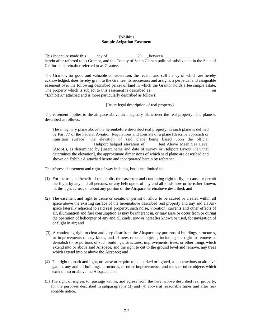
Exhibit 1
Sample Avigation Easement
This indenture made this ____ day of ______________20 __, between _________________________ herein after referred to as Grantor, and the County of Santa Clara a political subdivision in the State of California hereinafter referred to as Grantee.
The Grantor, for good and valuable consideration, the receipt and sufficiency of which are hereby acknowledged, does hereby grant to the Grantee, its successors and assigns, a perpetual and assignable easement over the following described parcel of land in which the Grantor holds a fee simple estate. The property which is subject to this easement is described as _____________________________on “Exhibit A” attached and is more particularly described as follows:
[Insert legal description of real property]
The easement applies to the airspace above an imaginary plane over the real property. The plane is described as follows:
The imaginary plane above the hereinbefore described real property, as such plane is defined by Part 77 of the Federal Aviation Regulations and consists of a plane [describe approach or transition surface]: the elevation of said plane being based upon the official ___________________ Heliport helipad elevation of _____ feet Above Mean Sea Level (AMSL), as determined by [insert name and date of survey or Heliport Layout Plan that determines the elevation], the approximate dimensions of which said plane are described and shown on Exhibit A attached hereto and incorporated herein by reference.
The aforesaid easement and right-of-way includes, but is not limited to:
(1) For the use and benefit of the public, the easement and continuing right to fly, or cause or permit
the flight by any and all persons, or any helicopter, of any and all kinds now or hereafter known, in, through, across, or about any portion of the Airspace hereinabove described; and
(2) The easement and right to cause or create, or permit or allow to be caused or created within all
space above the existing surface of the hereinabove described real property and any and all Air-space laterally adjacent to said real property, such noise, vibration, currents and other effects of air, illumination and fuel consumption as may be inherent in, or may arise or occur from or during the operation of helicopter of any and all kinds, now or hereafter known or used, for navigation of or flight in air; and
(3) A continuing right to clear and keep clear from the Airspace any portions of buildings, structures,
or improvements of any kinds, and of trees or other objects, including the right to remove or demolish those portions of such buildings, structures, improvements, trees, or other things which extend into or above said Airspace, and the right to cut to the ground level and remove, any trees which extend into or above the Airspace; and
(4) The right to mark and light, or cause or require to be marked or lighted, as obstructions to air navi-
gation, any and all buildings, structures, or other improvements, and trees or other objects which extend into or above the Airspace; and
(5) The right of ingress to, passage within, and egress from the hereinabove described real property,
for the purposes described in subparagraphs (3) and (4) above at reasonable times and after rea-sonable notice.
7-2

For and behalf of itself, its successors and assigns, the Grantor hereby covenants with the County of Santa Clara, for the direct benefit of the real property constituting the ________________ Heliport hereinafter described, that neither the Grantor, nor its successors in interest or assigns will construct, install, erect, place or grow in or upon the hereinabove described real property, nor will they permit to allow, any building structure, improvement, tree or other object which extends into or above the Airspace or which constitutes an obstruction to air navigation, or which obstructs or interferes with the use of the easement and rights-of-way herein granted.
The easements and rights-of-way herein granted shall be deemed both appurtenant to and for the direct benefit of that real property which constitutes the ________________________ Heliport, in the County of Santa Clara, State of California; and shall further be deemed in gross, being conveyed to the Grantee for the benefit of the Grantee and any and all members of the general public who may use said easement or right-of-way in landing at, taking off from or operating such helicopter in or about the __________________________ Heliport, or in otherwise flying through said Airspace.
Grantor, together with its successors in interest and assigns, hereby waives its right to legal action against Grantee, its successors, or assigns for monetary damages or other redress due to impacts, as described in Paragraph (2) of the granted rights of easement, associated with helicopter operations in the air or on the ground at the heliport, including future increases in the volume of changes in location of said operations. Furthermore, Grantor, its successors, and assigns shall have no duty to avoid or mitigate such damages through physical modifications of heliport facilities or establishment or modification of helicopter operational procedures or restrictions. However, this waiver shall not apply if the heliport role or character of its usage (as identified in an adopted heliport master plan for example) changes in a fundamental manner which could not reasonably have been anticipated at the time of the granting of this easement and which results in a substantial increases in the impacts associated with helicopter operations. Also, this grant of easement shall not operate to deprive the Grantor, its successors or assigns, of any rights which may from time to time have against any air carrier or private operator for negligent or unlawful operation of a helicopter.
These covenants and agreements run with the land and are binding upon the heirs, administrators, executors, successors and assigns of the Grantor, and, for the purpose of this instrument, the real pro-perty firstly hereinabove described is the servient tenement and said __________________ Heliport is the dominant tenement.
DATED: ____________ _________________________________________________ _________________________________________________
STATE OF CALIFORNIA } ss COUNTY OF SANTA CLARA }
On _____________, before me, the undersigned, a Notary Public in and for said County and State, personally appeared __________________________________________________________, and ___________________________________________ known to me to be the persons whose names are subscribed to the within instrument and acknowledged that they executed the same.
WITNESS my hand and official seal.
____________________________________________
Notary Public
7-3

Exhibit 2 Sample Deed Notice
The following statement should be included on the deed and recorded by the County for any property located within the Heliport Influence Area. This statement should also be included on any parcel map, tentative map or final map for subdivision approval for any property within the Heliport Influence Area.
The Santa Clara County Heliport Comprehensive Land Use Plan identifies Heliport Influence Areas. Properties within these areas are routinely subject to overflights by helicopter using the associated heliport and, as a result residents may experience inconvenience, annoyance or discomfort arising from the noise or sight of such operations. State law (Public Utilities code sections 21670 et. Seq.) establishes the importance of heliports to protection of the public interest of the people of the State of California. Residents of property near such heliports should therefore be prepared to accept the inconvenience, annoyance or discomfort from normal helicopter operations. Residents also should be aware that the current volume of helicopter activity may increase in the future in response to government needs, Santa Clara County population and/or economic growth. Any subsequent deed conveying this parcel or subdivisions there of shall contain a statement in substantially this form.
7-4

8-1
Section 8
8 HELIPORT SPECIFIC DETAILS
8.1 Heliport Specific Land Use Compatibility Plan
8.1.1 Data Template
Certain information about the Heliport, such as the helicopters using the facility, the number of operations and the time of day anticipated for the operations, the approach and departure paths, etc., are required in order to develop a HLUCP plan for the facility. The information needed is identified by the following template: 8.1.2 Parameters for heliport under consideration
Design helicopter make and model – __________________________ Helipad design data: TLOF dimensions – (See Table 3-1 above) _____________________ FATO dimensions – (See Table 3-1 above) _____________________ Safety Area dimensions – (see Table 3-1 above) ___ ft beyond FATO outer edge Noise Contour data: Arrival and departure paths: Magnetic bearings from helipad and altitudes (see above in Part 77.23 data) ______________________ Average number of flights per day by time period: 7 AM to 7 PM ______________________ 7 PM to 10 PM _____________________ 10 PM to 7 AM _____________________ FAA FAR Part 77.23 data: Approach Surface – (from TLOF edge) ___ ft by 4000 ft by 500 ft at outer edge @ 8 to 1 slope Transitional Surfaces – (from TLOF edge) ____ ft by 250 ft long at a slope of 2 to 1 Approach Path(s) – Any direction from ___ deg to ____ deg but principally an arrival heading of ____ deg., or ____ deg., and a departure heading of ____ deg. Safety Zone data: Helipad Protection Zone (HPZ) – (from TLOF outer edge) ____ ft wide by 280 ft long (centered under approach paths) Inner Safety Zone (ISZ) – (from outer edge of HPZs) ____ ft by 1720 ft long underlying the FAR Part 77.23 Approach Surface Sideline Safety Zones (SSZ) – Extending 250 ft out from FATO (not TLOF) edge @ 2 to 1 slope 8.1.3 Figures to be developed
Figure 2 – Heliport Layout Plan Figure 3 – Typical Flight Tracks Figure 4 – General Plan Land Use Figure 5a – Heliport CNEL Noise Contours Figure 5b – Heliport SEL Noise Contours Figure 6 – FAR Part 77.23 Surfaces Figure 7 – Heliport Safety Zones Figure 8 – Heliport Influence Area

2 Heliport Layout Plan
8-2

Figure 3 Typical Helicopter Flight Tracks
8-3

8-4
Figure 4 General Plan Land Use

8-5
Figure 5a Heliport CNEL Noise Contours

8-6
Figure 5b Heliport SEL Noise Contours

8-7
Figure 6 FAR Part 77 Surfaces

8-8
Figure 7 Heliport Safety Zones

8-9
Figure 8 Heliport Influence Area