Embed Size (px)
Citation preview

Complete StreetsCandidate Project Evaluator
User’s Guidehttp://leegis.leegov.com/completestreets/
User’s Guide
1

Complete StreetsCandidate Project Evaluator
LEE COUNTY
Candidate Project Evaluator Web Pagehttp://leegis.leegov.com/completestreets/
LEE COUNTYSOUTHWEST FLORIDA G I S
2
Complete StreetsCandidate Project Evaluator
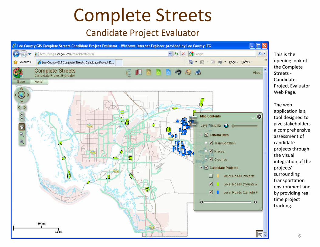
This is the opening look of the Complete Streets -Candidate Project Evaluator Web Page.
The web application is a tool designed to give stakeholders give stakeholders a comprehensive assessment of candidate projects through the visual integration of the projects’ surrounding transportation environment and by providing real time project tracking.
6
Complete StreetsCandidate Project Evaluator
7
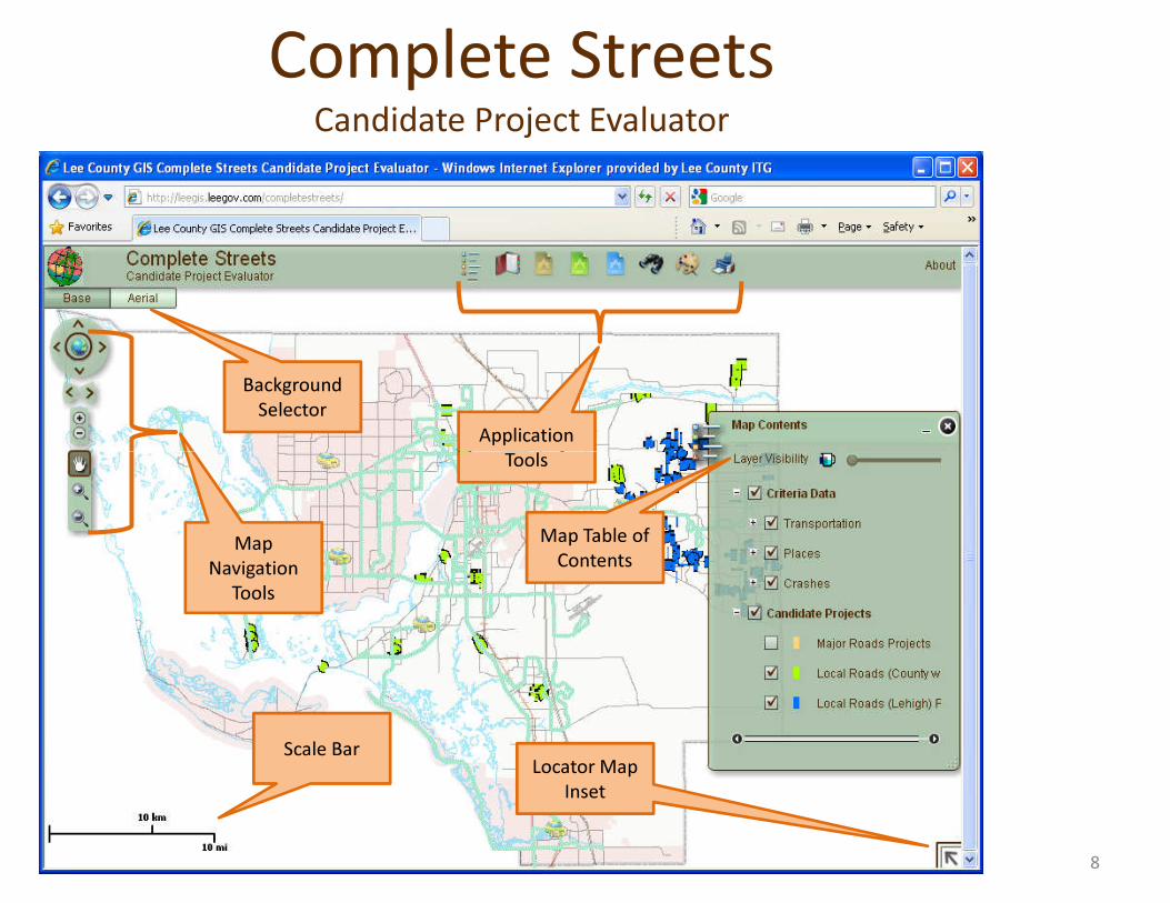
Background Selector
Application Tools
Complete StreetsCandidate Project Evaluator
Map Navigation
Tools
Tools
Map Table of Contents
Scale Bar Locator Map Inset
8
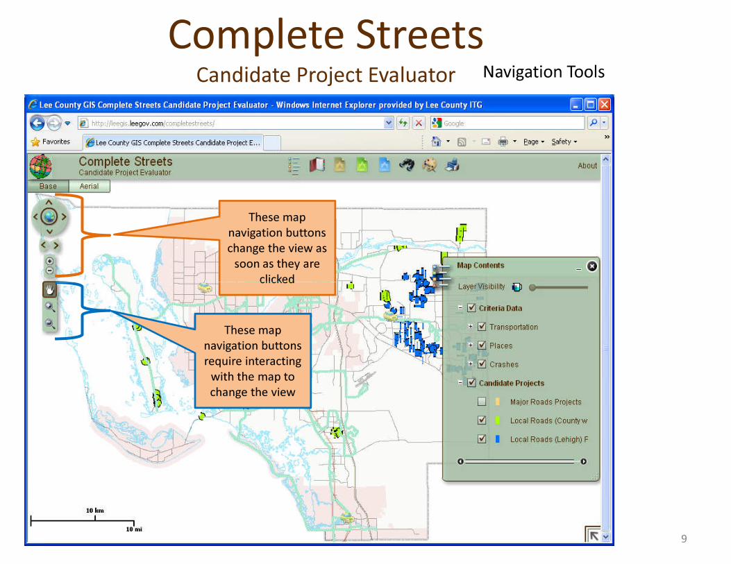
These map navigation buttons change the view as
soon as they are clicked
Navigation ToolsComplete Streets
Candidate Project Evaluator
clicked
These map navigation buttons require interacting
with the map to change the view
9
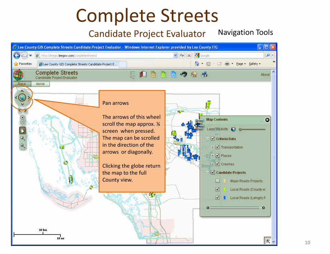
Pan arrows
The arrows of this wheel scroll the map approx. ¼
Navigation ToolsComplete Streets
Candidate Project Evaluator
scroll the map approx. ¼ screen when pressed. The map can be scrolled in the direction of the arrows or diagonally.
Clicking the globe return the map to the full County view.
10
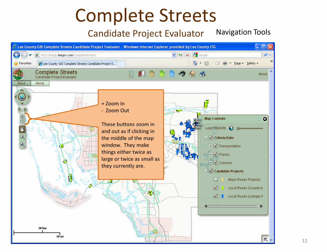
+ Zoom In- Zoom Out
These buttons zoom in
Navigation ToolsComplete Streets
Candidate Project Evaluator
These buttons zoom in and out as if clicking in the middle of the map window. They make things either twice as large or twice as small as they currently are.
11
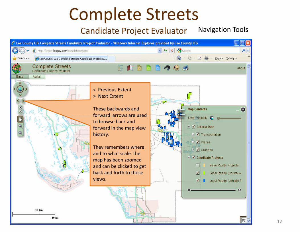
< Previous Extent> Next Extent
These backwards and forward arrows are used
Navigation ToolsComplete Streets
Candidate Project Evaluator
forward arrows are used to browse back and forward in the map view history.
They remembers where and to what scale the map has been zoomed and can be clicked to get back and forth to those views.
12
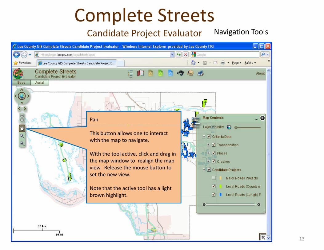
Pan
Navigation ToolsComplete Streets
Candidate Project Evaluator
This button allows one to interact with the map to navigate.
With the tool active, click and drag in the map window to realign the map view. Release the mouse button to set the new view.
Note that the active tool has a light brown highlight.
13
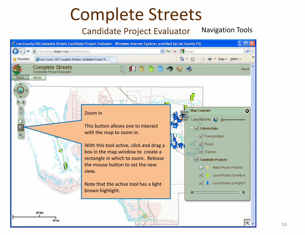
Zoom In
Navigation ToolsComplete Streets
Candidate Project Evaluator
This button allows one to interact with the map to zoom in.
With this tool active, click and drag a box in the map window to create a rectangle in which to zoom. Release the mouse button to set the new view.
Note that the active tool has a light brown highlight.
14
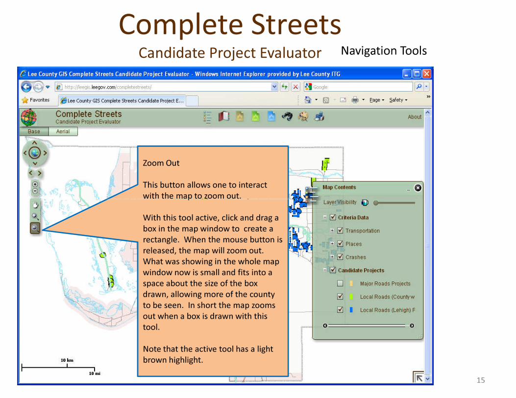
Zoom Out
This button allows one to interact with the map to zoom out.
Navigation ToolsComplete Streets
Candidate Project Evaluator
with the map to zoom out.
With this tool active, click and drag a box in the map window to create a rectangle. When the mouse button is released, the map will zoom out. What was showing in the whole map window now is small and fits into a space about the size of the box drawn, allowing more of the county to be seen. In short the map zooms out when a box is drawn with this tool.
Note that the active tool has a light brown highlight.
15
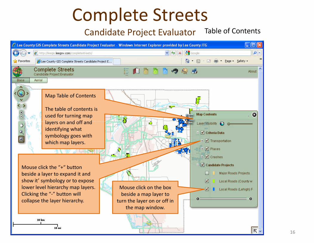
Map Table of Contents
The table of contents is used for turning map layers on and off and
Table of ContentsComplete Streets
Candidate Project Evaluator
layers on and off and identifying what symbology goes with which map layers.
Mouse click the “+“ button beside a layer to expand it and show it’ symbology or to expose lower level hierarchy map layers. Clicking the “-” button will collapse the layer hierarchy.
Mouse click on the box beside a map layer to
turn the layer on or off in the map window.
16
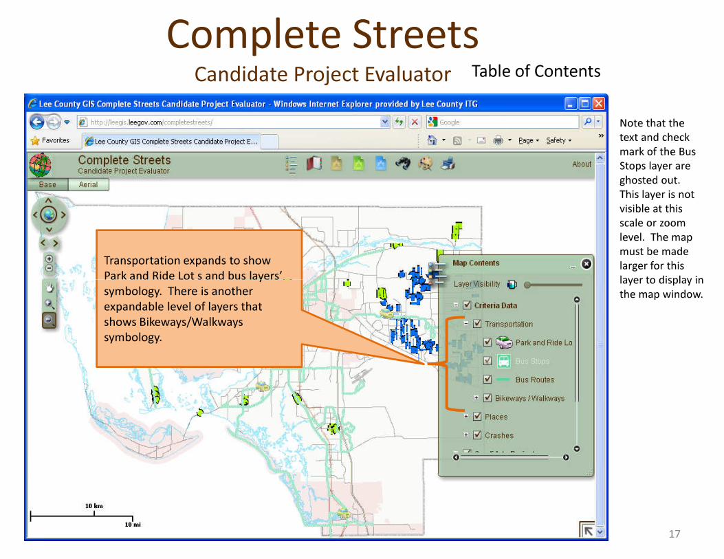
Transportation expands to show Park and Ride Lot s and bus layers’
Note that the text and check mark of the Bus Stops layer are ghosted out. This layer is not visible at this scale or zoom level. The map must be made larger for this layer to display in
Table of ContentsComplete Streets
Candidate Project Evaluator
Park and Ride Lot s and bus layers’ symbology. There is another expandable level of layers that shows Bikeways/Walkways symbology.
layer to display in the map window.
17
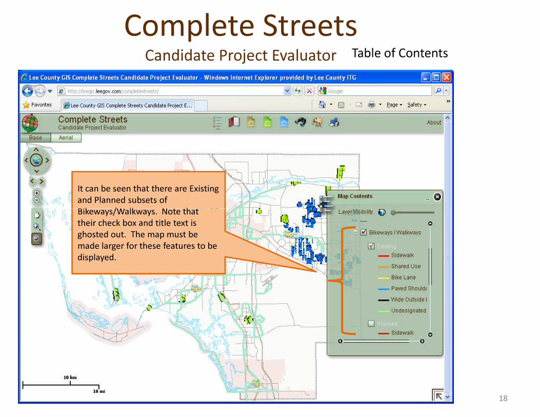
Table of Contents
It can be seen that there are Existing and Planned subsets of Bikeways/Walkways. Note that
Complete StreetsCandidate Project Evaluator
Bikeways/Walkways. Note that their check box and title text is ghosted out. The map must be made larger for these features to be displayed.
18
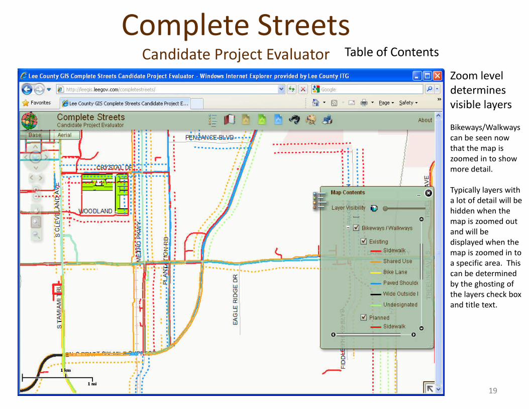
Table of ContentsZoom level determines visible layersBikeways/Walkways can be seen now that the map is zoomed in to show more detail.
Typically layers with a lot of detail will be
Complete StreetsCandidate Project Evaluator
a lot of detail will be hidden when the map is zoomed out and will be displayed when the map is zoomed in to a specific area. This can be determined by the ghosting of the layers check box and title text.
19
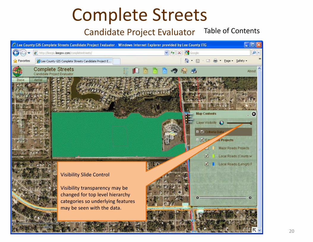
Table of ContentsComplete Streets
Candidate Project Evaluator
Visibility Slide Control
Visibility transparency may be changed for top level hierarchy categories so underlying features may be seen with the data.
20
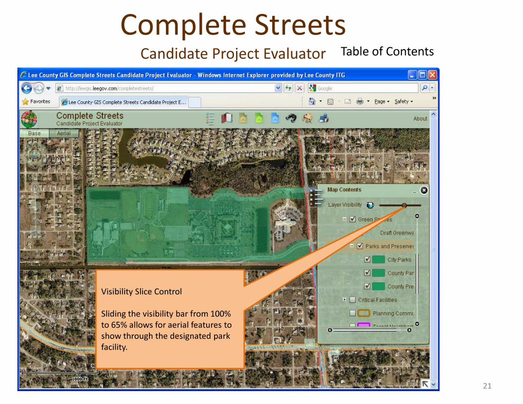
Table of ContentsComplete Streets
Candidate Project Evaluator
Visibility Slice Control
Sliding the visibility bar from 100% to 65% allows for aerial features to show through the designated park facility.
21
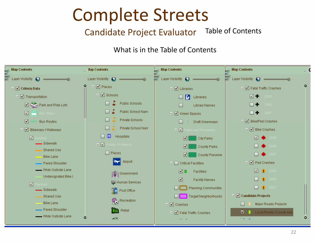
Table of Contents
What is in the Table of Contents
Complete StreetsCandidate Project Evaluator
22
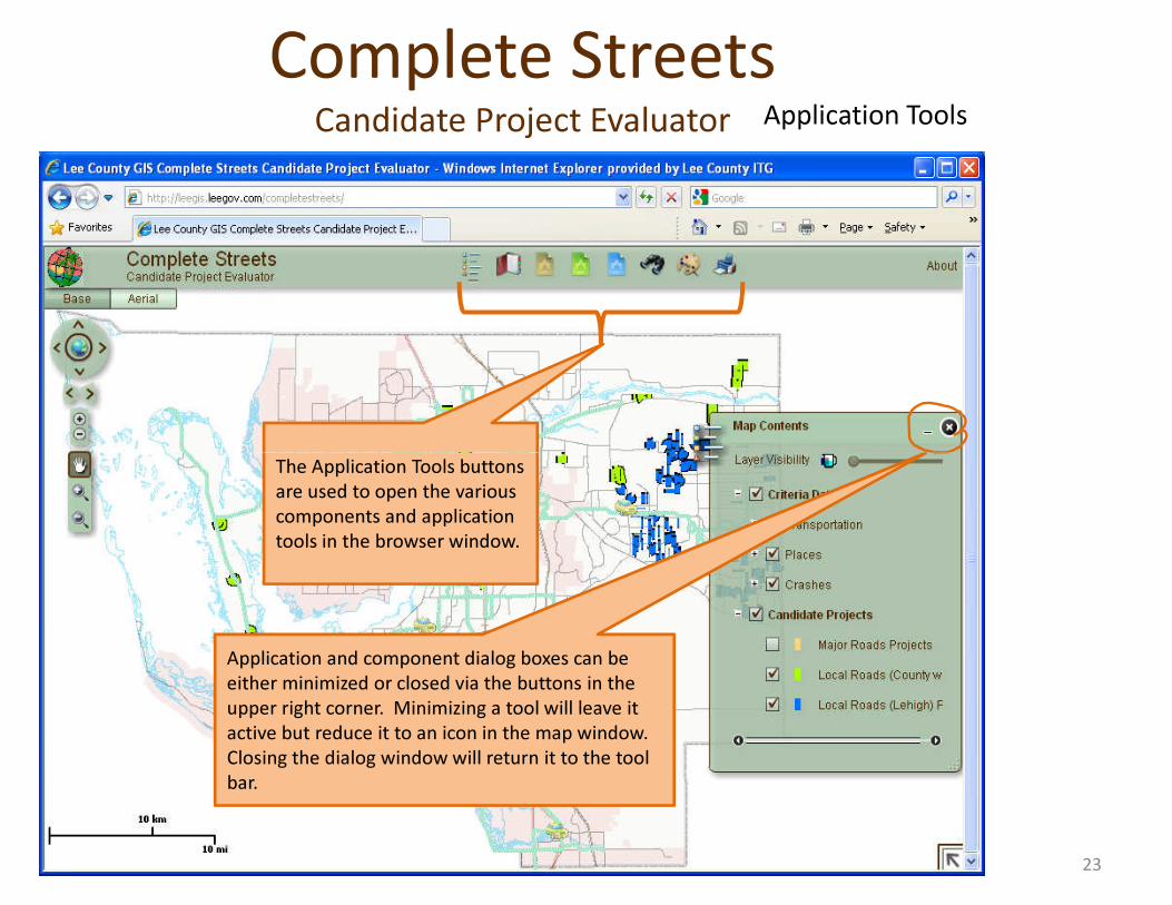
Application ToolsComplete Streets
Candidate Project Evaluator
The Application Tools buttons are used to open the various components and application tools in the browser window.
Application and component dialog boxes can be either minimized or closed via the buttons in the upper right corner. Minimizing a tool will leave it active but reduce it to an icon in the map window. Closing the dialog window will return it to the tool bar.
23
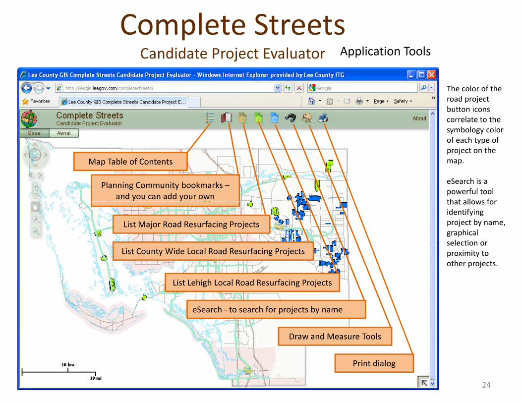
Map Table of Contents
Planning Community bookmarks –and you can add your own
Application Tools
The color of the road project button icons correlate to the symbology color of each type of project on the map.
eSearch is a powerful tool that allows for
Complete StreetsCandidate Project Evaluator
List Lehigh Local Road Resurfacing Projects
eSearch - to search for projects by name
Draw and Measure Tools
Print dialog
List County Wide Local Road Resurfacing Projects
List Major Road Resurfacing Projects
that allows for identifying project by name, graphical selection or proximity to other projects.
24
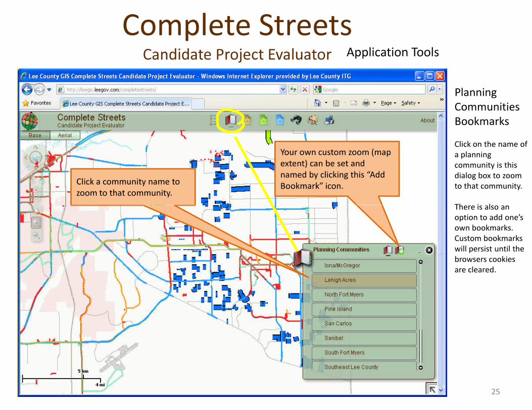
Application Tools
Planning Communities BookmarksClick on the name of a planning community is this dialog box to zoom to that community.
There is also an
Click a community name to zoom to that community.
Your own custom zoom (map extent) can be set and named by clicking this “Add Bookmark” icon.
Complete StreetsCandidate Project Evaluator
There is also an option to add one’s own bookmarks. Custom bookmarks will persist until the browsers cookies are cleared.
25
Application Tools
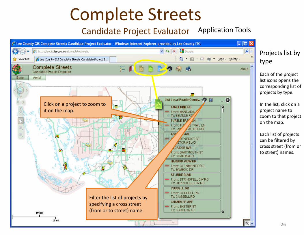
Projects list by typeEach of the project list icons opens the corresponding list of projects by type.
In the list, click on a project name to zoom to that project
Click on a project to zoom to it on the map.
Complete StreetsCandidate Project Evaluator
zoom to that project on the map.
Each list of projects can be filtered by cross street (from or to street) names.
Filter the list of projects by specifying a cross street (from or to street) name.
26
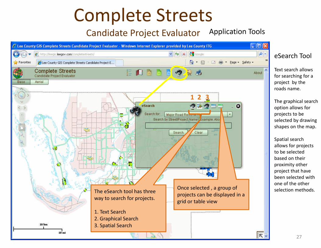
1 2 3
eSearch ToolText search allows for searching for a project by the roads name.
The graphical search option allows for projects to be selected by drawing shapes on the map.
Application ToolsComplete Streets
Candidate Project Evaluator
The eSearch tool has three way to search for projects.
1. Text Search2. Graphical Search3. Spatial Search
shapes on the map.
Spatial search allows for projects to be selected based on their proximity other project that have been selected with one of the other selection methods.Once selected , a group of
projects can be displayed in a grid or table view
27
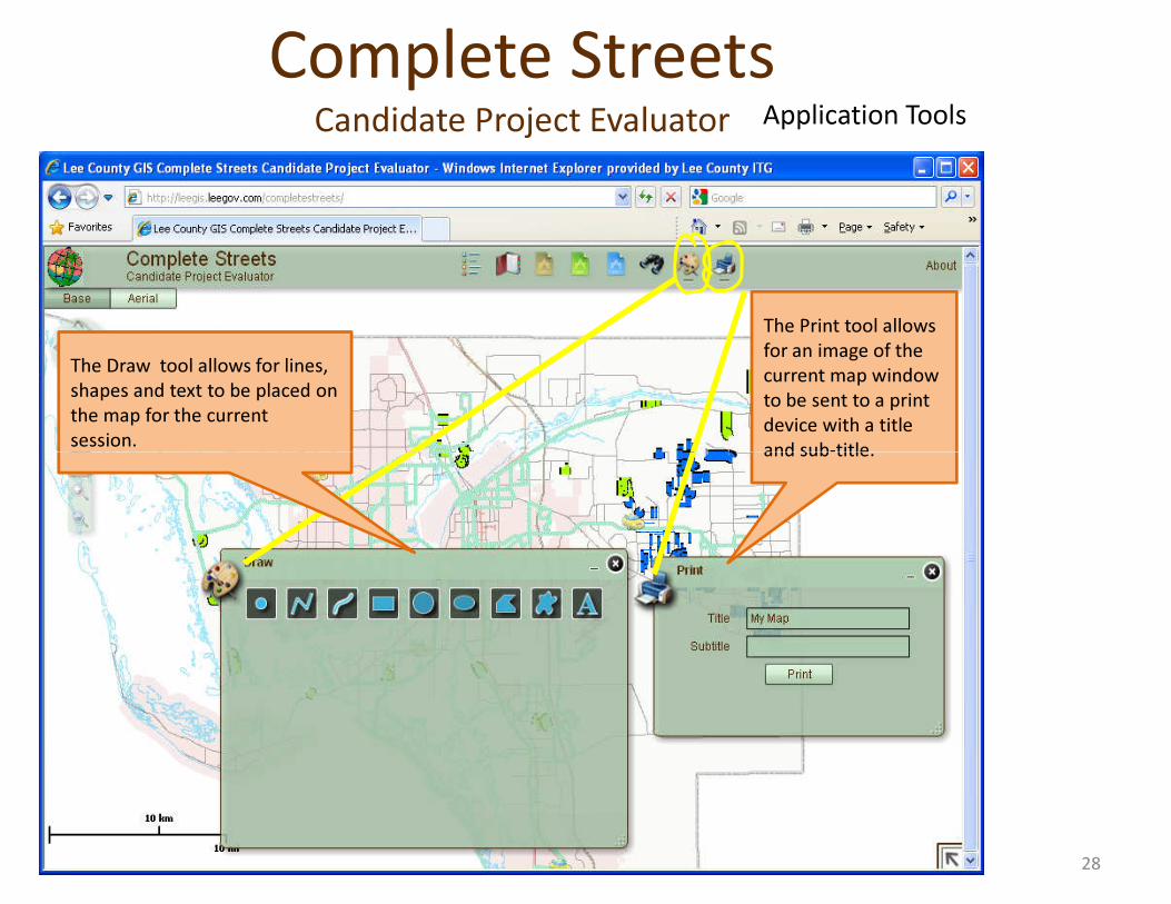
The Draw tool allows for lines, shapes and text to be placed on the map for the current session.
The Print tool allows for an image of the current map window to be sent to a print device with a title and sub-title.
Application ToolsComplete Streets
Candidate Project Evaluator
and sub-title.
28
Application Tools
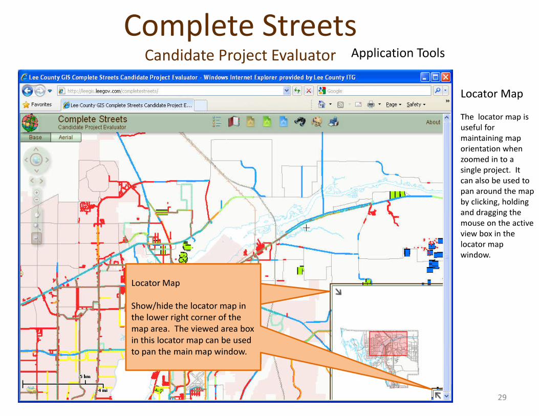
Locator MapThe locator map is useful for maintaining map orientation when zoomed in to a single project. It can also be used to pan around the map by clicking, holding and dragging the
Complete StreetsCandidate Project Evaluator
Locator Map
Show/hide the locator map in the lower right corner of the map area. The viewed area box in this locator map can be used to pan the main map window.
and dragging the mouse on the active view box in the locator map window.
29
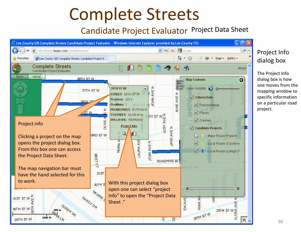
Complete StreetsCandidate Project Evaluator
Project Info dialog boxThe Project Info dialog box is how one moves from the mapping window to specific information on a particular road project.
Project Data Sheet
With this project dialog box open one can select “project Info” to open the “Project Data Sheet .”
Project info
Clicking a project on the map opens the project dialog box. From this box one can access the Project Data Sheet.
The map navigation bar must have the hand selected for this to work.
30
Complete StreetsCandidate Project Evaluator
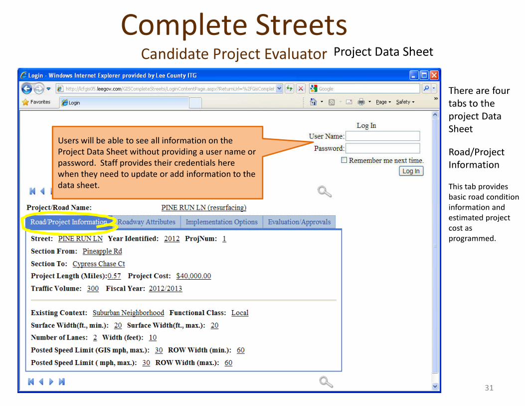
There are four tabs to the project Data SheetRoad/Project Information This tab provides basic road condition information and
Users will be able to see all information on the Project Data Sheet without providing a user name or password. Staff provides their credentials here when they need to update or add information to the data sheet.
Project Data Sheet
information and estimated project cost as programmed.
31
Complete StreetsCandidate Project Evaluator
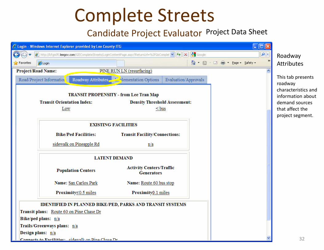
Roadway Attributes This tab presents roadway characteristics and information about demand sources that affect the project segment.
Project Data Sheet
32
Complete StreetsCandidate Project Evaluator Project Data Sheet
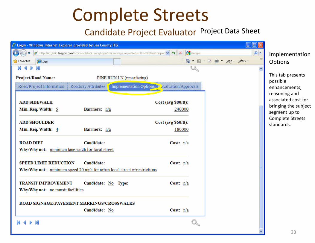
Implementation OptionsThis tab presents possible enhancements, reasoning and associated cost for bringing the subject segment up to Complete Streets standards.standards.
33
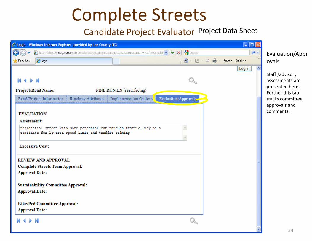
Complete StreetsCandidate Project Evaluator Project Data Sheet
Evaluation/ApprovalsStaff /advisory assessments are presented here. Further this tab tracks committee approvals and comments.
34

Complete StreetsCandidate Project Evaluator
LEE COUNTY
Candidate Project Evaluator Web Pagehttp://leegis.leegov.com/completestreets/
LEE COUNTYSOUTHWEST FLORIDA G I S
36