Embed Size (px)
Citation preview

C O M PARATIVE STUD IES OF OXIC HORIZONS
A TH E SIS SUBM ITTED TO THE G RAD U ATE DIVISION OF TH E U N IVERSITY OF HAWAn
IN P A R T IA L F U L F IL L M E N T OF TH E REQUIREM ENTSFOR TH E DEGREE OF
M ASTER OF SCIENCE
IN SO IL SCIENCE
JAN U AR Y, 1969
By
Nuanchavde Yaibuathes
Thasis Committao:
Haruyoshi Ikawa, Chairman Samir A . El-Swaify Duane P . Bartholomew

We certify that we have read this theeia and that in our
opinion it is satisfactory in scope and quality as a thesis for the
degree of Master of Science in Soil Science.
TH E SIS COMMITTEE
Chairman

The author would like to express her appreciation particu
larly to Dr. L . D. Swindale who made this work possible, to
the people who collected and sent the soil samples, and to
Cmdr. K . Sukhapinta, RN, who sent the data on the climate of
various places in Tliailand.
Thanks go to the staff and friends of the Hawaii Institute of
Geof^ysics for their assistance. Many thanks go to Miss Sandra
Yee and Mrs. Annie T . Chang for their help and encouragement.
The author is deeply indebted to the U . S . and the Royal
Thai Governments for their support through the A .I .D . scholar
ship. A lso, the author would like to thank the staff in the
Institute of Technical Interchange of the East-West Center who
are representatives of A .I .D .
ACKNOW LEDGM ENTS

ACKNOW LEDGM ENTS ......................................................... i
L IS T OF T A B L E S ............................................................. Hi
L IS T OF F IG U R E S ............................................................. v
INTRODUCTION . . . ..................................................... 1
General Statement of the P ro b lem .............................. 1
Definitions of Terms to be U sed .................................. 2
REVIEW OF L I T E R A T U R E .............................................. 6
The Classifioation of Laterites, Latosols,and O x is o ls .................................................................... 6
The Nature of the Oxic H orizon.................................. 7
Significance to Soil C lassifica tion .............................. 11
M ATE R IALS AND M E T H O D S .......................................... 12
Soil D escrip tion ............................................................. 12
Satr.ple P r e p a ra t io n ..................................................... 31
Methods of A n a ly s is ..................................................... 31
R E S U L T S AND D IS C U S S IO N .......................................... 37
Chemical P r o p e r t ie s .................................................... 67
Physical P r o p e r t ie s ..................................................... 72
Mineralogical P r o p e r t ie s ............................................. 78
Profile C haracteristics................................................. 92
Comparison of Oxic H o r izo n s ...................................... 98
SUMMARY AND C O N C L U S IO N S ...........................................103
U T E R A T U R E C I T E D ..............................................................105
II
T A B L E OF C O N TE N TSPage

iii
la
lb
Ic
Id
le
lla
Ilb
IIo
lid
He
llla
lllb
Illo
llld
llle
IVa
IVb
IVc
IVd
Table
Some Chemical Properties of Molokai Soil
Some Physical Properties of Molokai Soil
Differential Thermal Analysis Data of Molokai S o i l .......................... ......................
L IS T OF T A B L E S
X -ray Diffraction Analysis Data of Molokai Soil
Some Properties of Molokai Soil . . . .
Some Chemical Properties of Pooku Soil
Some Physical Properties of Pooku Soil
Differential Thermcd Analysis of Pooku Soil
X -ray Diffraction Analysis of Pooku Soil
Other Properties of Pooku S o i l ...............
Some Chemical Properties of T erra Roxa L e ^ t im a ................................ ...............................
Some Physical Properties of Terra Roxa Legitima .....................................................
Differential Thermal Analysis of Terra Roxa Legitima .....................................................
X -ray Diffraction Analysis of T erra Roxa Legitima .....................................................
Some Properties of Terra Roxa Legitima
Some Chemical Properties of Sadao Soil
Some Physical Properties of Sadao Soil
Differential Thermal Analysis of Sadao Soil
X -ray Diffraction Analysis of Sadao Soil .
39
40
40
41
42
43
44
44
45
46
47
49
50
51
53
55
56
56
57
Page

Iv
U S T OF T A B L E S (C O N TIN U E D )
Table
IVe Other Properties of Sadao S o i l ............................
Va Some Chemical Properties of the Oxic Horizons
Vb Some Physical Properties of the Oxic Horizons
Vc Differential Thermal Analysis of the OxicH o r iz o n s .................................. ... ......................
Vd X -ray Diffraction Analysis of the Oxic Horizons
Ve Some Other Properties of the Oxic Horizons .
VI Some Characteristics of the Four Soil Profiles
VII Some of the Characteristics of the Oxic Horizons
58
59
61
62
63
65
93
Page
99

U S T OF FIGURES
la
lla
Ilia
IVa
Ib
Ilb
lllb
IVb
Vb
Figure
Diflerential Thermal Curves ol Whole Soli in the Profile of Molokai S o i l ...................
Differential Thermal Curves of Whole Soil in the Profile of Pooku Soil ...................
Differential Thermal Curves of Whole Soil in the Profile of T erra Roxa Legitima Soil .
Differential Thermal Curves of Whole Soil in the Profile of Sadao Soil and the Oxio Horizons of the Soils from Thailand . . . .
X -ray Diffraction Patterns of K-Saturated Clay in the Profile of Molokai S o i l ...........................
X -ray Diffraction Patterns of K-Saturated Clay in the Profile of Pooku Soil t • •
X-ray Diffraction Patterns of K-Saturated Clay In the Profile of T erra Roxa Legitima Soil . .
X -ray Diffraction Patterns of K-Saturated Clay in the Profile of Sadao S o i l ..............................
X -ray Diffraction Patterns of K-Saturated Clay in the Oxic Horizons of the Soils from Thailand
79
80
81
82
85
86
87
90
91
Page

INTRODUCTION
General Statement of the Problem
In 1951, the Soil Survey Staff of the Soil Conservation
Service, U S D A , proposed the Comprehensive Soil Classification
System. It was an attempt to classify soils based on the proper
ties of soils with less emphasis on the genetic factors which were
important in the Great Soil Group Classification System. This
was a practical system and it seemed that it covild be used
effectively in the classification of soils not only in the United States,
but also in many areas of the world. However, during the
development of the new classification system, it became apparent
that there was a need for nore study in certain groups of soils.
For example, as pointed out by the Soil Survey Staff (1960),
more inforrr ation and investigation were necessary to classify the
order Oxisols. This order includes soils which have been called
Latosols and Ground-Water Laterite soils and which are found
only in the tropical and subtropical regions. Thus far, Oxisols
from Hawaii and Puerto Rico have been investigated. There is a
need to study the Oxisols from other areas of the world and to
compare the properties of these soils.
F o r the reasons mentioned above, soils from Hawaii, Brazil,
and Thailand were investigated. The two soils from Hawaii were
the Molokai and the Pooku of the Low Humic Latosol and Humic

Ferruginous Latosol Great Soil Groups, respectively. The soil
from Brazil, similar to the Hawaiian latosol, was the Terra Roxa
Legitima. Lastly, the soils from Thailand included the Sadao soil
profile and three horizons believed to be oxic horizons.
The objectives of this investigation were:
1. To determine the chemical, physical, and mineralogical
properties of the oxic horizons of these soils.
2. To test the definition of the oxic horizon using the
results of this investigation.
3. To modify the definition of the oxic horizon if necessary.
The results of each property were discussed and the four
soil profiles from Hawaii, Brazil, and Thailand were compared.
The oxic horizons of these soils were also compared.
Definition of Terms to be Used
Laterites
The word laterite first appeared in scientific literature
approximately 150 years ago. Buchanan (1807) is believed to be
the first to notice a ferruginous deposit of vesicular structure
occurring just below the soil surface. When fresh, this deposit
was cut easily into blocks. When exposed to air, these blocks
hardened and became highly resistant to weathering. Matgnien
( 1 9 6 6 ) reported more than 2 , 0 0 0 references dealing with laterites.
According to him, the early studies in India during the first half
2

of the Nineteenth Century dealt widi the descriptions of laterites
and their mode of occurrence. Then, from the end of the
Nineteenth Century, studies were carried out on the chemical and
to some extent the mineralogical properties. In recent times,
various instrumental methods have been used to investigate these
properties. Based on these results, more knowledge on the
genesis of laterites was obtained.
Although laterites have been described and investigated for
many years, the word latsrite has not been clearly defined.
TTierefore, the terms ’’laterite, ” latosol," and •’ground-water
laterite” will be used in this study as defined by the Soil Survey
Staff (Kellogg, 1949).
"Laterite" is described as ferruginous materials which
harden after drying. The four principal forms of laterites are:
(1 ) Soft mottled clays that change irreversibly to hard pans or
crusts; (2 ) cellular and mottled hard pans and crusts; (3 ) con
cretions or nodules in a matrix of unconsolidated materials; and
(4 ) consolidated masses of concretions or.nodules.
"Ground-water laterite" are soils having layers of ck>ughy
laterite beneath a leached horizon which is not called plinthite
(Alexander and Cady, 1962).
Latosols
The term "latosol" has been proposed for all zonal soils in
the tropical and equatorial regions. The dominant characteristics
3

are ( 1 ) low silica-aesquioxides ratio in the clay fraction; ( 2 ) low
base exchange capacity; (3 ) low content of most primary miner
als; (4 ) low content of soluble constituents; (5 ) high degree of
aggregate stability; and ( 6 ) perhaps some red color. Latosols
are similar to the zonal soils previously called lateritic soils.
Oxic Horizon
According to the Soil Survey Staff (1967), the oxic horizon
is defined as follows:
The oxic horizon is an altered subsurface horizon at least 30 cm (12 inches) thick consisting of a mixture of hydrated oxides of iron or aluminum<, or both, often amorphous, and variable amounts of 1 : 1 lattice clays and accessory highly insoluble minerals such as quartz sand.Its fine-earth fraction has little or no 2:1 lattice clay or primary minerals that can weather to release bases, iron or aluminum. For each 1 0 0 grams of clay that it contains, the fine earth holds 1 0 m eqorless of cations from>IN NH4 CI and has a cation-exchange capacity by NH4 OAc of 16 meq or less. The oxic horizon has a lower exchange capacity or smaller amounts of minerals that can weather physically or chem ically than the cambic horizon.It differs from, the argillic horizon in having few or no clay skins and in having either a gradual or diffusa increase in clay content with depth, or no increase. Its upper boundary is set at the least depth at which there is no water-dispersible clay. For diagnostic purposes, its lower boundary is usually set at a depth of 2 meters.
Oxisols
According to the Soil Survey Staff (1967), the Oxisols are
defined as follows:
Oxisols are mineral soils that have an oxic horizon at some depth within 2 meters (80 inches) of the
4

surface’*' or plinthite that forms a continuous phase within 30 cm ( 1 2 inches) of the mineral surface of the soil.No spodio or argillic horizon overlies the oxic horizon.
’̂ If the epipedon is thicker than 2 m (80 inches), and is immediately underlain by an oxio horizon, the soil is grouped with the Oxisols.
Plinthite
Plinthite may be defined as follows (Soil Survey Staff,
1967):
Plinthite is a sssquioxide rich, humus poor, highly weathered mixture of clay with quartz and other diluents, which commonly occurs as red mottles, usually in platy, polygonal or reticulate pattern; plinthite changes irreversibly to ironstone hardpans or irregular aggregates on exposure to repeated wetting and drying. The lower boundary of plinthite occurrence are usually diffuse or gradual, but they may be abrupt at the lithologic discontinuity.

The Classification ol Laterltes, Latosols, and Oxisola
Soil classification can either be synthetic or analytical (Manil,
1956). Synthetic classification systeins can be divided into three
main groups: (1 ) classification based on genetic factors (U S S R
systen ); ( 2 ) classification based on soil genetic processes
(French and Portuguese systems); (3 ) classification based on the
properties of pedogenetic processes (British and Australian
systems). Analytical classification systems, on the other hand, is
based mainly on morphological characteristics with a bias towards
soil genetic considerations (F A O , Belgian and USA systems).
The classification systems cited by Maignien (1966) include
map legends and cartographic units used by the Service
P edologique Interafrican.
Dual and Moorman (1962) grouped the mqjor soils of South
east Asia according to the Comprehensive Soil Classification
System and classified the dark red and reddish brown latosols
and red yellow latosols as Oxisols. They also classified some of
the grey-podzolic soils, for example, the Thai Korat series, as
ground-water laterites.
In the Belgian classification systen:, the lateritic soils are
those overlying a ferrallitio B horizon with the characteristics ol
an oxio horizon. The lateritic soils were classified as kaolisols
REVIEW OF L ITE R A TU R E

and ware comparable to the Oxisola. The kaoHsols were divided
into five sub-types according to pedoclimate: ( 1 ) hygro-kaolisols
(Ustox), the kaolisols of low attitude tropical forest; ( 2 ) hydro-
xero kaolisols (Ustox), low base saturation savannah kaolisols;
(3 ) xero-kaolisols (idox, xerox ), dry-savannah kaolisols with
high base saturation; (4 ) humic kaolisols (humox), mountain belt
kaolisols; and (5 ) hydro-kaolisols (aquox), hydromorphic
kaolisols.
In South America, Camargo and Bennema (1962) grouped
the laterites with soils containing a latosolio B horizon, a horizon
equivalent to the oxic horizon.
In the Comprehensive Soil Classification System, not all of
the soils formerly classified as laterites or latosols are Oxisols.
In general, Oxisols have an oxic horizon or show the presence
of plinthite.
The Nature of the Oxic Horizon
The oxic horizon is a diagnostic subsurface horizon which
is found in soils of the tropical and subtropical regions. These
soils are commonly found on very old stable geomorphic surfaces
(at least mid-Pleistocane)—old high-level surfaces, high terraces
and pediments occurring at elevations not over 1,500 to 2 , 0 0 0
meters. TTiey also occur on young surfaces if the parent materi
als were strongly weathered before they were deposited.
7

AcoorcUng to Mohr (1944), the Oxisols are in the senile or
the laterite stage. The laterite was referred to as "the bones of
the dead soil." Similarly, Jackson and Sherman (1955) have
described the laterite as being in the advanced stages of chemical
weathering.
Field Characteristics Associatad with Oxic Horizons
The oxic horizon normeJly underlies an umbric, ochric,
histic, or perhaps a m.ollic epipedon, and it can be exposed only
by truncation. Many investigators have called the oxic horizon
the B horizon, while others have called it the C horizon.
Although the epipedon may contain 5 to 109S organic matter,
the color change between the horizons may be gradual and the
boundary may bo diffused. It is often difficult, therefore, to
differentiate the upper boundary of the oxic horizon (Soil Survey
Staff, 1967). The oxic horizon, however, can be characterized
in the field primarily by its structure and consistence. It may
appear massive and m.ay possess very weak, very coarse
prismatic structure. It may also have weak or medium blocky
structure. Fragments from the oxic horizon can be easily
crushed between the fingers into fine granules which are usually
very stable. The lower boundary of the oxio horizon is usually
sot at 2 meters if the solum is vary deep.
In contrast to the argillic horizon which is found in the
Ultisols and Aifisols, the oxic horizon in the Oxisols shows little
8

or no evidence of clay movennant in the profile.
Laboratory Characteristics of Oxic Horizons
The identification of the oxic horizon in the laboratory
requires one or more of the following measurements (Soil Survey
Staff, 1967):
Percentage of weatherable minerals in the sand fraction— The
oxic horizon should contain less than 3% feldspar, glass, and
ferromagnesian minerals in the 2 0 - 2 0 0 u sand, and there may be
as much as 6 % mica ( muscovite).
Particle size distribution by pipette method using sodium hexa-
metaphosphate or by 15-bar water retention method—It is essentied
to determine the clay content in order to express the cation
exchange capacity of this horizon. Since there may be some
difficulty in dispersing certain soils to mieasure the clay content,
an independent measure has been recom.mended by the Soil Survey
Staff. This was obtained by determining the 15-bar water and
multiplying this result by a factor of 2.5. The higher value of the
two methods was then used to express the cation exchange
capacity of the clay.
The ratio of 15-bar water to the clay content (pipette method)
has been used to indicate the dispersible characteristic of the soil.
The ratio does not exceed 0.5 if the clay disperses. The ratio
is 0.4 for moat oxic horizons.
9

The oxic horizon should have nn.oro than 15% clay because
of the low silt content, and the coarsest texture should be between
loamy sands and sandy loams.
Cation retention—After being saturated with 1 ^ NH^CI
solution, pH 5.2, and washed free of excess salt, the oxic horizon
should retain the ammonium ions equal to or less than 1 0 meq/ 1 0 0
g of clay.
Cation exchange capacity— The cation exchange capacity
(C £ C ) of the oxic horizon by buffered ammonium acetate is equal
to or less than 16 meq/100 g of clay. This limitation excludes
soils with high am.ounts of allophane.
Thin sections— Preparation of the thin sections is necessary
when field investigation cannot differentiate the argillic horizon and
the oxic horizon. If the features of the formier are observed, the
clay skin should not exceed 1 % in the oxic horizon.
Water-dispersible clay— The distribution of water-dispersible
clay in a profile can be used to locate the upper boundary of the
oxic horizon. The amount should be less than 3% in the oxic
horizon if this horizon does not have a net positive charge.
Clay mineralogy— The influence of the clay minerals appears
to be important. Mineralogioal analysis may indicate the presence
of clay mineral or allophane which possesses properties which are
not usually associated with the oxic horizons.
10

Significance to Soil Claasification
In general, soils with oxic horizons in their natural states
are considered to be unsuitable for agriculture. Weathering has
progressed to such a stage that only the resistant primary miner
als, hydrous oxides of iron and aluminum, and 1 : 1 lattice clay
minereds (kaolin) remain. Bonnet (1966), however, recently
found that crop production can be increased in the tropical humid
soils with an oxic horizon when properly managed; for example,
by irrigation.
11

M A TE R IA LS AND METHODS
Soil Description
Tbe soils used for this study were the Molokai, Pooku,
Terra Roxa Legitima, Sadao, Siracha, Thamai, and Yasothon
series. The following is a detailed description of each soil.
Location:
Classification:
Molokai Silty Clay Loam
1.7 miles north of Farrington Highway, Kunia
Road Junction and turn west 0.05 mile on dirt
road. Sample site is northern road bank.
Tropeptic Haplustox (L ow Humio Latosol).
Parent Material: Basic igneous material.
Vegetation:
Physiography:
Elevation:
Climate:
Described and collected by:
Horizon
A p j 0-30 cm
(0-12 inches)
Sugar cane.
Gentle slope, 0-2% south.
457.3 m (1,500 ft).
Mean annual tem.perature: 22.8*C (7 3 *F ).
Average January temperature: 21. 7*C (71 * F ) .
Average July temperature: 25*C (7 7 *F ).
Annual rainfall: 375-625 mm (15-25 inches).
tL . D. Swindale, H. Ikawa, S . A . El-Swaify,
C. Sangtian, and N . Yaibuathes.
Depth Description
Dark reddish brown (2 .5YR 3/4)
silty clay loam; very weak coarse

13
Horizon Depth
Ap 2 30-82.5 cm
(12-33 inches)
^ 2 182.5-110 cm
(33-44 inches)
Description
granular structure; slightly hard,
friable, sticky and plastic; many
roots; many interstitial pores;
many fine black (iron-manganese)
concretions; strong effervescence
with hydrogen peroxide; slightly
acid; clear wavy boundary.
Dark red (lOR 3/6) silty clay;
weak coarse prismatic structure;
hard friable to firm, sticky and
plastic; fine common roots; many
fine and fine tubular pores; com
mon black ( iron-manganese) con
cretions; strong effervescence with
hydrogen peroxide.
Dark red (lOR 3/6) silty clay
loam; weak to moderate blocky
structure; hard friable to firm,
sticky and plastic; few fine roots;
few very fine black (iron-
manganese) concretions; moderate
effervescence with hydrogen
peroxide.

14
B 2 2 110-130 cm
(44-55 inches +)
Horizon Depth Description
Dark red (lOR 3/6) silty clay;
strong medium angular and sub-
angular blocky structure; soft,
friable compaction in place, sticky
and plastic; very few fine roots;
very fine pores; prominent thin
patchy clay films on peds.
Location:
Classification:
Parent Material;
Vegetation:
Physiography:
Elevation:
Climate:
Pooku Silty Clay
250 feet south of highway at a point 1.1 miles
southwest of Bailey Bridge at Kalihiwai,
approximately 4 miles west of Kilauea, Kauai.
Approximately 14 miles northwest of Lihue,
Kauai.
Typic Acrohumox (Humic Ferruginous Latosol).
Believed to be weathered from residium from
basic igneous rock.
Pangola pasture.
Low windward slopes, slightly convex to south
west. Slopes, 1-2% at sample site.
97.5 m (320 ft).
Mean annual temperature: 21.7*C (7 1 *F ).
2032-2331 mm (80-90 inches) of rainfall

15
Described and collected by:
distributed throughout the year.
Williams and Foote, S C S , U SD A.
Horizon Depth
A p i 0-37.5 cm
(0-15 inches)
Ap 2 37.5-47.5 cm
(15-19 inches)
Description
Dark yellowish-brown (lO YR 4/4)
silty clay mottled with reddish-
brown (5YR 4/4) material by
tillage; strong very fine subangular
blocky structure; friable, sticky
and plastic; many very fins and
fine pores; many iron concretions
that have a dense dark outer shell
with softer yellowish center; abrupt
smooth boundary.
Dark yellowish-brown (lO YR 4/4)
silty clay mottled with reddish-
brown (5YR 4/4) material by
cultivation; weak fine subangular
blocky structure; friable, sticky
and plastic; common fine and very
fine roots; many fine and common
fine pores; many iron concretions
similar to the first horizon; clear
and snooth boundary.

16
B 2 1 47.5-7S cm
(19-30 inches)
Horizon Depth
B 2 2
C l
75-100 cm
(30-40 inches)
100-155 cm
(40-62 inches)
Description
Dark reddish-brown (5YR 3/4)
silty clay loam; weak fine sub-
angular blocky structure; friable,
sticky, plastic; common fine and
very fine pores; nearly continuous
pressure surfaces; few very firm
non-magnetic particles that appear
to be segregated iron; clear
smooth boundary.
Dark reddish-brown (5YR 3/4)
silty clay; moderate fine subangular
blocky structure; friable, sticky,
plastic; common fine and very fine
roots; common very fine and fine
pores; nearly continuous pressure
suHaces; few patchy cutans that
have a mGallic sheen; few sapro-
lite fragments; this horizon is
underlain by discontinuous iron
seam containing a build up of roots;
abrupt wavy boundary.
Variegated dark reddish-brown
(5YR 3/3), yellowish-red (5YR

17
Horizon Depth
155-225 cm
(62-90 inches)
Description
3/6), red (SYR 4/6), dusky-red
(2 .SYR 2/2) loem; weak coarse
platy structure; friable with pockets
of firm material, slightly sticky,
slightly plastic; few very fine and
fine roots; few very fine and fine
pores; near the bottom is a pan
that appears to have a fine platy
structure; the thin plates appear to
be hematite and gibbsite, are very
firm and brittle, and are separated
by a very porous material that has
a sponge-like structure; above the
pan is 1 / 2 to 2 inches of extreme
ly porous and friable material
thickly coated with a dark material
which appears to be discrete sand
under magnification; the bottom part
next to the contact is coated with
very thick cutans which appear to
be clay skins.
Variegated dark reddish-brown
(5YR 2/2), dark reddish-brown

Horizon Depth
Remark*:
Description
(2 .SYR 3/4), dark red (2 .SYR
3/6), very dark reddish-brown
(lO YR 3/2) loam; friable with
pockets of firm material, and
material with hue of 2 .SYR has a
moderately snieary feel, slightly
sticky, slightly plastic; massive
structure; there are nriany sheets
of firm material that are thought to
be made up of hematite at the top
and gibbsite at the bottom.; thick
cutcms appear like clay flows occur
on the bottom of these lens.
18
While grinding the sample, weathered phenocrysts of Fe-Mg
minerals as large as 1 mm were observed.
Location:
Classification:
Terra Roxa Legitima
Experimental Station of the Institute Agronomico
Ribeirao Preto County, State of Sao Paulo,
B razil.
( Humic Latosol).
p€u*ent Material: Basalt.

19
Physiography:
Elevation:
Climate:
Vegetation:
Described and collected by:
Horizon
A jp
Sugar cane— present. Subtropical forest—
original.
Undulating. Midway on a slope 1,000 m long.
Slope 5-10%.
(?)Mean annual temperature: 2 l.5 *C ; 1 8 in
dry season and 24*C in rainy season. Annual
rainfall: 1,300 mm, with 3 to 4 months of dry
season from June to September; rainy season
occurs from October to April.
Depth
0-16 cm
(0-6.3 inches)
31
A . Kupper and A , C . Moniz.
Description
Dusky red (lOR 3/3) silty clay;
fine to very fine granular structure;
sticky and plastic; abrupt and
smooth boundary.
Dusky red (lOR 3/3) clay;
moderate to strong fine subanguiar
blocky structure; more than 50% of
strongly developed aggregates are
hard and 0.5 cm in diameter and
15-20% are very hard when dry;
gradual to smooth boundary.
16-45 cm;
(6.3-17.7 inches)

19
Physiography:
Elevation:
Climate:
Vegetation: Sugar cane— present. Subtropical forest—
original.
Undulating. Midway on a long slope with about
1,000 m long. Slope 5-10%.
(?)
Mean annual temperature: 21.5*'C; 16*C in
dry season and 24*C in rainy season. Annual
rainfall: 1,300 mm, with 3 to 4 months of dry
season from June to Soptem.ber; rainy season
occurs from October to April.
Described and collected by:
Horizon
A IP
Depth
0-16 cm
(0-6.3 inches)
A 31
A . Kupper and A . C. Moniz.
Description
Dusky red (lOR 3/3) silty clay;
fine to very fine granular structure;
sticky and plastic; abrupt and
smooth boundary.
Dusky red (lOR 3/3) clay;
moderate to strong fine subangular
blocky structure; more than 50% of
strongly developed aggregates are
hard and 0.5 cm in diameter and
15-20% are very hard whan dry;
gradual to sm<ooth boundary.
16-45 on.
(6.3-17.7 inches)

20
45-63 cm
(17.7-24.8 inches)
Horizon Depth
32
' 2 163-90 cm
(24.8-35.4 inches)
Description
Dusky red (lOR 3/3) clay; moderate
very fine subangular blocky struc
ture; approximately 40% of the
aggregates are very porous; these
aggregates are less than 1 cm in
diameter and are friable, few are
firm to vary firm; friable, very
sticky, very plastic; gradual to
diffuse and smiooth boundary.
Dusky red ( lOR 3/3) clay; massive,
showing a very weak subangular
blocky structure breaking rapidly
to miedium poorly developed, sub
angular blocky structure and fur
ther breaking to very fine (less
than 2 mm) subangular blocky
structure (the so-called "coffee
powder") ; 20-25% of very porous
friable aggregates, most of which
are less than 0.5 cm in diameter
and somte with diameters between
1 and 2 cm, vary sticky, vary
plastic, gradual to diffusa and
smooth boundary.

21
Horizon
2̂2
IIB
l I IC i
Depth
90-105 cm
(34.5-41.3 inches)
105-160 cm
(41.3-63 inches)
160-216 cm
(63-65 inches)
Description
Dusky red (lOR 3/3) clay; massive,
breaking readily to medium, poorly
developed subangular blocky
structure, and further breaking to
very fine (less than 2 mm) sub
angular blocky structure ( "coffee
powder"); friable with 15% of fria
ble aggregates less than 1 cm in
diameter, very sticky, very
plastic; gradual and wavy
boundau'y.
Dusky red (lOR 3/3) clay; massive,
breaking readily to medium, poorly
developed subangular blocky
structure further breaking to very
fine (less than 2 mm) subangular
blocky structure ("coffee powder");
5% firm and dense aggregates;
very friable, very sticky, very
plastic; gradual and wavy
boundary,
Dusky red (lOR 3/3) clay; massive,
breaking readily to poorly

developed medium subangular
blocky structure ( "coffee powder");
5-10% of hard aggregates, mostly
2-5 mm in diameter; very friable,
very sticky, very plastic; gradual
and wavy boundary.
C 2 216-250 cm (85-98.4 inches).
C 3 250-300 cm (98.4-119.1 inches). C 2 to Cg sampled
300-350 cm (118.1-137.8 inches). with an auger; no
C 5 350-400 cm (137.8-157.5 inches). description of the
400-450 cm (157.5-177.2 inches). horizons were
C j 450-500 cm (177.2-196.9 inches). recorded.
Cg 500-575 cm (196.9-226.4 inches).
Remarks;
Much sugar cane roots up to 3 mm in thickness were seen
throughout the profile, even at the depth of 216 cm. In the C j
horizon a hole made by animals was found. In comparison to the
other horizons the IIB3 and IIICj horizons had a higher concen
tration ol small stones from basic rocks of about 5 mm diameter
and completely altered into gibbsite and a few iron concretions.
Those stones seemted to have been transported and for this
reason It looks as if the parent material of the B3 and C 3
22
Horizon Depth Description

horizons may have been transported, although they both appear to
have been derived from basic rocks.
23
Location:
Classification:
Sadao Series
Amphoe Muang, Changwat Pattalung, Southern
Thailand.
Haplorthox ( Red Latosol).
F arent Material: Old alluvium.
Vegetation:
P hysiogr aphy:
Elevation:
Climate:
Described and collected by:
Tall dense evergreen forest.
Rolling high ridge, old alluvium or marine
terrace, slope 2 - 8 %.
50 m +.
Mean annual air temperature: 27.2*C. Annual
rainfall: 2413.1 mm (96.5 inches).
Horizon Depth
0-7 cm.
( 0 - 2 . 8 inches)
D. L . Gallup and S . Panichapong.
Description
Reddish-brown (5YR 4/4) loam.y
sand; weak medium and fine
subangular blocky structure; soft;
friable, non-stioky, non-plastic;
plentiful medium and fine roots;
many fine and medium pores; many
pieces of charcoal; pH 5.0; clear
smooth boundary.

24
A 3 7-19 cm
(2 .8-7 .5 inches)
Horizon Depth
B l
Box.
19-33 cm
(7.5-13 inches)
33-80 cm
(13-31.5 inches)
Description
Reddish-brown (SYR 4/3) sandy
loam to loamy sand; weak fine
subangular blocky structure; fria
ble, non-sticky, non-plastic; many
medium and fine roots; many fine
and medium tubular pores; few
pieces of oharooal; pH 5.0.
Reddish-brown (2. SYR 4/3) sandy
loam; weak fine subangular blocky
structure; friable, non-sticky,
non-plastic; many medium and fine
roots; m.any fine and medium and
tubular pores; few pieces of
charcoal; pH 5.0; gradual, smooth
boundary.
Reddish-brown (2. SYR 4/3) sandy
loam; weak fins subangular blocky
structure; friable, non-sticky,
non-plastic; common medium and
fine roots; many fine tubular
pores; few pieces of charcoal; pH
S.O; gradual, smiooth boundary.

80-150 cm +
(31.5-59.1 inches)
Horizon Depth
B0 X2
Remarki
Description
Reddish-brown (2 .5YR 4/3 ) heavy
sandy loam; weak medium and fine
subanguiar blocky structure; fria
ble, slightly sticky, slightly plastic;
common fine and medium few large
roots; many medium and fine
tubular pores; thin patchy clay film
in pores and some vertical ped
faces on termite nest, 8 cm by 2
cm, at 9 8 - 1 0 0 cm depth.
25
This Sadao Series has no A 2 horizon; in other localities a
clear A 2 horizon may be seen. This soil thus appears to be a
transition between an Ultisol and an Oxisol or it is an Oxisol in
which a leached A 2 horizon is formed.
Location:
Classification:
Siraoha Series
Sample was taken from a profile approximately
100 m from km 119 on Sukumvit Road,
Amphoe Siraoha, Changwat Chonburi, Thailand.
Ustox (Red-Yellow Latosol).
Parent Material: Material derived from mica schist.

26
Physiography:
Elevation:
Climate:
Vegetation:
Described and collected by:
Horizon
A l
Agriculture land used for maruoc and various
fruit trees.
Rolling—incised old marine terrace adjacent to
low hills. Slope 6-10% west.
Approximately 35 m.
Mean annual temperature: 27.9*C. Average
annual rainfall approximately 1,300 mm with
pronounced dry season from November to May.
F . R . Moormann.
Depth
0 - 1 2 cm
(0-4.7 inches)
12-26 cm
(4.7-11 inches)
"̂ ox 28-120 cm +
(11-47.2 inches)
Description
Dark reddish-brown (5YR 3/4)
sandy loam or loam; strong fine
crumb structure; soft; very
porous, low bulk density; clear,
regular boundary.
Dark-reddish-brown (2 .5YR 3/4)
sandy loam or loam; strong fine
crumb; weak fins subangular
blocky structure in spots; soft;
very porous, low bulk density;
gradual, regular boundary.
Dark red ( lY R 3/6) loam (7 );
fine angular quartz gravels

27
Horizon Depth Description
present, very weak fine subangular
blocky stinjcture; soft; very
porous with many layer holes and
channels; low bulk density.
(Note: Whan exposed, the dry
Box material becomes rather
hard.)
Location:
Classifioation:
Parent Material:
Vegetation:
Physiography;
Elevation:
Climate:
Thamai Series
Readout in front of Wat Bot Floy Wan, some 50
m south of M ERSPD 259 site, Amphoe Thamai,
Changwat Chantaburi, Thailand.
( Red Brown Latosol).
Residium from basalt and/or volcanic ash.
Abandoned land with grass and shrubs;
surroundings consist of a wide variety of tropi
cal fruits, pepper, and rubber.
Undulating, slightly incised basalt plateau.
Slope 6 % southeast.
Approximately 30 m.
Mean annual temperature: 27.3*C. Annual
rainfedl: 2930.6 mm.
F . R . Moormann and Santhad.

28
A J 0-9 cm
(0-3.5 inches)
Horizon Depth
B jox 9-60 cm
(3.5-23.6 inches)
B 2 OX 60-150 cm +
(23.6-59.1 Inches)
Description
Dark reddish-brown (5YR 3/3)
clay; strong fine crumb; friable;
many interstitial pores of various
sizes; many roots; pH 5.5; clear
smooth boundary.
Dark reddish-brown (5YR 3/4)
clay; moderate fine subangular
blocky structure; very friable; low
bulk density; many animal holes;
many fine tubular pores; many
roots; pH 5.5; clear smooth
boundary.
Dark reddish-brown (SYR 3/4)
clay; moderate fine subeungular
blocky structure and when dried,
coarse prismatic with vertical
cracks; very weak clay movement;
slightly hard when dry but very
friable when moist; some animed
holes; many fine tubular pores;
common roots; very little change
with depth; pH 5.0.

29
Location:
Classification:
Yasothon Series
Burrow pit in dry dipterocarp forest, near
Khon Kaen University, Amphoe Muang, Chang
wat Khon Kaen, north-eastern Thailand.
Ustox (? ) (Red Yellow Latosol).
Parent Material: Old alluvium.
Vegetation: Yopa ( Morinda crures). Sat, Oaeng ( Xylia
kerrii). teng (shorea obtusa), Nam Khon
( Zizyphus cambodiana) , Kadon ( Carey a
arborea). Mokyai, Huan Kwang.
Rolling high terrace. Slope 2%.
200-205 m.
Annual mean temperature: 27.2*C, highest at
42.8*C and lowest at 5.7®C. Tropical
monsoon, 1175 mm (47 inches) rainfall, distinct
dry season from November to April.
F hysiogr aphy:
Elevation:
Climate:
Described and collected by:
Horizon Depth
0 - 2 0 cm
(0-7.9 inches)
D. L . Gallup, Avudh, and S . Kasemsan.
Description
Dark brown (7 .5YR 3/2) sandy
loam; weak fine granular structure;
hard; friable, non-sticky, non
plastic; many fine roots; many fine
interstitial pores; pH 7.0; clear
wavy boundary.

30
Horizon
B.
Depth Description
Box.
20-27 cm
(7.9-10.6 inches)
27-49 cm
(10.6-19.3 inches)
Red (2 .SYR 3/2) sandy loam;
m.assive, hard; friable, non-sticky,
non-plastic; few fine and medium
roots; many fine tubular pores,
few medium pores; somiewhat
brittle, soil fractures abruptly
under pressure; few black spots of
charcoal; gradual sm̂ ooth boundary.
Rad (2 .SYR 4/6) sandy clay loam;
massive; very hard; friable,
slightly sticky, slightly plastic;
plentiful fine and mediumi roots;
many fine and few medium pores,
vertical crack about 75 cni in
length; somewhat brittle, soil
fractures under pressure; gradual
smooth boundary.
Red (2 .SYR 4/6) sandy clay loam;
(19.3-106.3 inches) weak medium subangular blocky
structure; slightly hard; friable;
slightly sticky, slightly plastic;
plentiful fine, few medium roots;
many fine, few tubular pores;
Boxo 49-270 cm

abrupt smooth boundary.
II and 270-500 cm. Fale brown (lO YR 6/3) andlaterite
(106.3-196.9 inches) laterite mottle dark yellowish-
brown (lO YR 4/6); quartzite,
sandstone and shale gravel
imbedded in laterite; upper part
very hard and strongly cemented,
lower part moderately cemented.
Sample F-reparation
After air-drying, the sample was gently crushed with a
wooden roller and passed through a 2-mm sieve. The sariiple
was thoroughly mixed and subsampled. One portion was ground
to pass through a 2 0 -mesh sieve for the determination of cation
exchange capacity. Another portion of the subsample was ground
to pass through a 1 0 0 -mesh sieve, thoroughly mixed, and stored
in a small glass vial for differential thermal and x-ray diffraction
analyses and for the determination of organic matter and free ii*on
oxide.
Methods of Analyses
Analytical methods described by the Soil Survey Staff
(1960) and others were used to identify or characterize the oxic
horizon.
31
Horizon Depth Deacription

Chemical Properties
Cation retention— Cation retention was determined after satu
rating the soil overnight with 1 .0 ^ ammonium chloride solution
and washing out the excess salt with methanol. The ammonium
ions at the exchange sites were replaced with sodium ions using
a solution of acidified sodium chloride (Peech et fiJ,, 1947). The
replaced am.monium ions were distilled with 1 : 1 sodium hydroxide
solution and the evolved ammonia was collected in 4 percent boric
acid. This acid solution was then titrated against standard
sulfuric acid using a mJxed indicator of methyl red and methylene
blue.
Cation exchange capacity and exchangeable bases— The air-
dried 2 0 -mesh soil was saturated overnight with 1 . 0 M ammonium
acetate solution buffered to pH 7. After filtering the soil suspen
sion through the Buchner funnel, the cation exchange capacity
(C E C ) of the soil was determ.ined by the procedure used for the
determination of cation retention. The filtrate was used to
determine the exchangeable bases Na, K , Ca, and Mg. Sodium
and K were determined by means of the Beckman DU Spectro
photometer, while Ca and Mg were determined by means of the
Perkin-Elmer, Model 303, Atomic Absorption Unit.
Soil pH— Soil pH was determined both in water (1:1 and
1:5) and in 1 KCl solution (1 :1 ) with a Beckman Expando-
matic pH meter. The suspension was kept overnight at constant
32

room temperature and stirred occasionally and the pH was taken
after stirring. Delta pH (ApH ), the difference between pH in
KCl (1 :1 ) and pH in H 2 O (1 :1 ), was also calculated (Soil
Survey Staff, I960).
Organic matter—Air-dried 100-mesh soil was used for
determination of organic matter content. The organic matter was
oxidized with dichromate and the excess dichromate was titrated
with standard ferrous sulfate solution (Walkley and Black, 1943).
Organic carbon content was estimated by using a recovery factor
of 77 percent and organic matter content was obtained by multi
plying the organic carbon content by a factor of 1.724.
F ree iron oxide— TTie dithionite extractable iron oxide method
of Kilmer (1960) was used to determine the free iron oxide
content. Due to the high percentage of free iron oxide in Hawaiian
soils, the size of the sample was reduced as suggested by
Mr. R . T . Watanabe (personal communication, 1968).
Fotassium chloride extractable aluminum—Aluminum was ex
tracted from the soil by the method of Chapman and Pratt (1961).
TTie aluminum content was determined oolorimetrically by the
aluminon method described by Hsu (1963). The procedure was
modified by adjusting the solution to pH 1.5, to ensure that the
final solution had a pH below 4. It was then heated at 90 *C for
30 minutes in the absence of the buffer solution before the color
33

was read on the Bauaoh & Lombe Colorimeter at a wavelength of
530 mu.
Fhyeioal Properties
Particle size cfistribution— Particle size distribution was
determined by the pipette method described by Kilmer and Alex
ander (1949), using sodium hexam.etaphosphate solution (Calgon)
as the dispersing agent. After 16 hours of m>echanical shaking,
the sand fraction was determined as that retained over a 300-
mesh sieve, while the clay fraction was determined on an aliquot
pipetted off from a certain depth of the suspension after a given
period of time. The silt fraction was obtained by subtracting the
sand and clay percentages from> 1 0 0 percent.
Water-dispersible clay— The procedure to determine water-
dispersible clay was the same as that described for particle
distribution. No dispersing agent, however, was used. H ie
sand and silt fraction data, furthermore, were not recorded.
Water held at 15-bar suction— The 15-beu» water retention
was measured using a pressure plate apparatus (U . S . Salinity
Laboratory Staff, 1954). The soil samples were saturated with
water and allowed to stand overnight after packing them in rubber
rings in the pressure plates. Then they were placed under 15-
bar pressure until equilibrium was reached. The water retained
at 15-bar was determined by removing the soils from the plates
34

and weighing the samples before and after oven-drying overnight
at 110-C.
Mineralogical F roperties
Differential thermal analysis (D T A )— The Stone Automatic
DTA apparatus was used. Air-dried 100-mesh whole soil was
kept for at least two days in a desiccator maintained at an atmos
phere of 57% relative humidity. Then a 0.1 g-sample, thoroughly
mixed with 0.1 g calcined alumina, was analyzed. Nitrogen gas
was passed through the sample to suppress the oxidation of
organic matter and calcined alumina was used as a reference
8 «unple. This analysis was determined primarily to detect the
amounts of gibbsite and kaolin.
X -ray diffraction analysis— The procedure described by
Jackson (1956) was used to determine the mineralogical compo
sition. Flocculents such as soluble electrolytes and exchangeable
polyvalent metallic cations, and cementing agents such as gypsum,
calcium carbonates, organic matter, hematite, goethite, colloidal
silica and/or alumina, and Mn0 2 were removed to obtain effective
dispersion and fractionation. Sodium acetate solution buffered to
pH 5.0 was used to remove the soluble salts, exchangeable poly
valent cations, and ccdcium and magnesium carbonates. Hydrogen
peroxide was used to destroy organic matter and to remove
manganese dioxide. The free iron oxides were then removed by
the sodium dithionite-citrate bicarbonate method. Finally, the soil
35

was dispersed in 2% sodium carbonate solution. The sand fraction
was separated by wot sieving using a 325-mesh sieve. The silt
(2-50u) and clay (< 2 u) fractions were separated by sedimentation
and centrifugation techniques.
H ie sand and silt fractions were dried and ground sepa
rately and x-ray diffraction patterns of the randomly oriented
powder were obtained by means of the Noreioo X -ray unit using
Cu radiation filtered with N i.
An aliquot of the clay suspension was saturated with 1.0 ^
potassium chloride solution. About 20-30 mg of this clay were
dried at room tern.perature on a glass slide. The preferentially
oriented K-saturated clay slide was x-rayed before and after
heating at 110*C, 350*C, and 500*C. Another aliquot of the clay
sample was saturated with 1 . 0 H magnesium chloride solution and
dried on a glass slide. The preferentially oHented Mg-saturated
clay slide was x-rayed before and after glycolation treatment
which consisted of keeping the slide overnight In an eth>4ane glycol
atmosphere at 70*C.
36

R E S U L T S AN D DISCUSSION
The results are presented in 25 tables. For ease of
comparison, every table is identified by two symbols. The first
is a Roman numeral which indicates the name of the soil and the
second is a lower-case letter which indicates the soil property.
Roman numerals I, II, 111, and IV thus indicate die Molokai,
Fooku, Terra Roxa Legitima, and Sadao soils, respectively.
Roman numeral V is the table for the oxic horizons of these soils
and the three soils from Thailand, the Siraoha, the Thamai, and
the Yasothon soils. Lower-case letters a and b identify the
chemical and physical properties. Mineralogical properties are
identified by lower-case letters, c and d. The letter o indicates
the interpretations of differential thermal analysis and the letter d
shows the mineralogical interpretations of x-ray diffraction analysis.
The lower-case letter e indicates the calculated variables.
The location of the oxic horizon was determined by analyz
ing the laboratory data in view of specifications presented earlier.
The oxic horizon occurs in the Molokai soil at a depth
from 82.5 to 130 cm+, while that of the Fooku soil is from 47.5
to 75 cm., which is slightly less than 30 cm. The oxic horizon
of the Terra Roxa Legitima occurs at a depth from 90 to 216 cm
while that of the Sadao soil is from 80 to 150 cm+. The oxic
horizons of the Siraoha, Thamai, and Yasothon soils are

probably taken from the B horizons. The Siracha sample prob
ably does not represent a true o^do horizon. Although Siracha
is classified as an Oxisol, the true upper boundary of the oxic
horizon may actually bo lower than that described. Laboratory
data for the Siracha horizon do not satisfy all the criteria for an
oxic horizon. The Yasothon horizon studied here also does not
seem to be a true oxic horizon. However, both the Siracha and
Yasothon soils are entered into the discussion whenever mineral
ogy property is studied.
38

Table la. Some Chemioal Properties of Molokai SoilHorizon Depth
cmCation Retention
(NH a CI) meo/lObg soil
CEC (NH^OAo 1pH 7)
Exchangeable Bases Basemeo/lOOg soil Saturation
meq/lOOg soil Na K Ca ^9 %
A p i 0 - 30 11.67 14.38 0.53 0.37 4.05 1.92 47.8
Ap 2 30 - 82.5 6.06 9-51 0.38 t 1.80 1.04 33.9
® 2 182 .5-110 6.72 7.75 0.34 0.04 1.55 1.04 37.8
B 2 2 1 1 0 -130 6.99 7.32 0.64 0.38 1.35 0.97 45.6
t “ trace
Table la. Some Chemioid Properties of Molokai SoU (Continued)Horizon Depth KCl Extractable
A1me<]/1 0 0 g soil
pH H2 O
1:5 1:1
pHKCl1 : 1
Free Iron Oxides (F e 2 0 3 )
OrgaiuoCarbon
%
OrganicMatter
%A p j 0 - 30 0 . 1 2 6.4 6 . 1 1 5.47 ‘2,7 18.2 1.91 3.29
Ap 2 30 - 82.5 0.03 6.4 5.95 5.60 19.8 0.85 1.47
B 2 I 82. 5-110 0 . 1 1 6.65 6.15 6 . 0 0 iiJ.2 21.7 0.40 0.69
® 2 21 1 0 -130 0.09 6.90 6.72 6.32 22.3 0.52 0.90
UiVO

40
Table lb. Some Physical Properties o! Molokai Soil
Horizon Depthcm
WaterDispersible
Clay%
15-BarWater
Retention%
Particle Size Distribution
%Sand %Silt %Clay
A p i 0 - 3 0 29.7 2 0 . 8 38.4 22.4 36.4
AP 2 30 - 82.5 17.6 19.9 23.0 15.8 52.2
® 2 182.5-110 6.5 20.4 16.7 43.3 40.0
B 2 2 110 -130 5.8 21.7 38.0 17.8 44.3
Table Ic. Differential Thermal Analysis Data of Molokai Soil
Horizon Depthcm
Low Temperature Kaolin Gibbsite Endothermic Water
Quartz
A p j 0 - 3 0 w m m -
Ap 2 30 -8 2 .5 w m m -
® 2 182.5-110 w m w -
B 2 2 110 -130 w m w -
w ** weak Lx>w Temperature Endothermic Water about 100*C m * moderate

41
Table Id. X-ray DiKraction Analysts Data of Molokai Soil
Horizon Depth Size Qcm Fraction
u
Gb G Ma He A K Mi
A p j
Ap 2
' 2 1
® 2 2
0 - 3 0 >50
<2
30 - 82.5 >50
vw vw - vw - - vw -
2-50 vw w - w w - w -
- - m vw
82.5-110
110 -130
2-50
<2
>50
2-50
<2
>50
2-50
<2
- w - - - -
vw vw - vw - - vw -
- w - w w - w -
- w - - - - m vw
» - - - vw -
- - - w w - w -
vw vw - - - - m -
- - - - - vw -
- - w m - w -
- - - - m -
s “ strong m “ moderate w “ weakw (b ) “ weak broadvw •= very weakvw (b ) "• very weak (broad)- ■■ none, not detected
Q “ Quartz Gb “ Gibbsite G “ Goethite Ma ~ Magnetite He •“ Hematite A " Anatase K - Kaolin Mi «* Mica
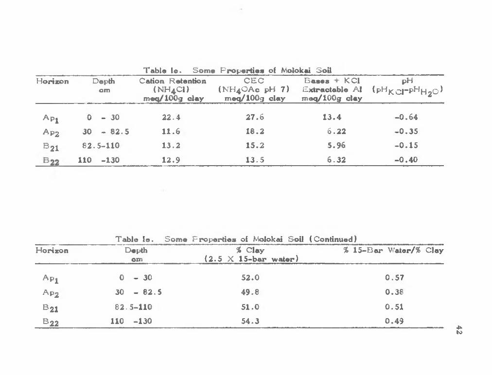
Table le. Some Fropertiee of Molokai SoilHorizon Depth
cmC€dion Retention
(N H 4 CI) meq/lOOg clay
CEC (N H 4 OAC pH 7)
meq/lOOg clay
Bases K Cl Extractable A1 meq/lOOg clay
pH ̂P*̂ JC o r P^H 2 0 ^
A p j 0 - 3 0 22.4 27.6 13.4 -0.64
Ap 2 30 - 82.5 11.6 18.2 6 . 2 2 -0.35
® 2 162.5-110 13.2 15.2 5.96 -0.15
110 -130 12.9 13.5 6.32 -0.40
Table le. Some Properties of Molokai Soil (Continued}Horizon Depth % Clay
cm (2.5 X 15-bar water)% 15-Bar Water/% Clay
A p j 0 - 30 52.0 0.57
AP2 30 - 82.5 49.8 0.36
^ 2 1 62 .5-110 51.0 0.51
^ 2 2 1 1 0 -130 54.3 0.494̂to

Table Ila. Some Chemical Properties of Pooku Soil
Horizon Depth Cation Retention cm ( NH4 CI)
meq/lOOg soil
CEC (NH4OAC pH 7 )
meq/lOOg soil
Exchangeable Bases Basemeq/lOOg soil Saturation
Na K Ca Mg %
A PI 0 - 37 5 7.75 18.86 0.14 0 0.20 t 1.8
Ap2 37.5- 47.5 12.10 20.30 0.09 0.07 0.43 t 2 . 9
B 2 1 47.5- 75 6.01 13.59 0.07 t 0.10 t 1.3
^22 75 -100 4.71 9.81 0 07 t 0.10 t 2.8
C l 100 -155 4.20 6.20 0.11 0 0.10 t 3.4
C 2 155 -225 1.82 4.23 0.14 t 0.20 t 8.0t “ trace
Table lla. Some Chemical Properties of Pooku Soil (Continued)Horizon Depth
cmKCl Extractable
A1meq/lOOg soil
pH H2 O
1:5 1:1
pHKCl1:1
Free Organic Iron Oxides* Carbon
(F e 2 0 3 ) %%
OrganicMatter
%
A p i 0 - 37.5 0.05 5.15 4.60 4.75 24.5 2.36 4.07
Ap2 37 5- 47.5 0.05 4.50 4.22 4 29 32.5 4.54 7.83
B 2 I 47.5- 75 0.04 5.50 5.10 5.35 26.2 1.64 2.83
^22 75 -100 0 01 5.60 5.25 5.57 26.1 1.18 2.03
C l 100 -155 0.10 5.43 5.40 5 65 23.5 0.88 1.52
C 2 155 -225 0.06 5.40 5.45 5.69 20 5 0.31 0.53♦Data from S C S , U S D A . Ca

44
Table Ilb. Some Physical Properties of Pooku Soil
Horizon Depthcm*
WaterDispersible
Clay%
15-BarWater
Retention^%
Particle Size Distribution
%Sand %Silt %Clay
A p i 0 - 37.5 6 . 6 30.2 6 6 . 8 16.9 16.3
Ap 2 37 5- 47.5 21.9 31.8 52.8 37.9 9.3
® 2 147.5- 75 2.9 31.7 80.0 3.9 17.1
® 2 2 75 -100 13 1 30.2 80.1 7.3 1 2 . 6
C l 100 -155 14.0 25.2 74.9 8.7 16.6
C 2155 -225 14.3 18.3 61.0 18.5 20.5
♦Data from S C S , USD A.
Table lie. Differential Thermal Analysis of Pooku Soil
Horizon Depthcm
Low Temiperature Kaolin Gibbsite Endothermic Water
Quartz
A p j 0 - 37.5 m - s -
Ap 2 37.5- 47.5 m - s -
® 2 1 47.5- 75 m - s -
® 2 275 -100 w - vs -
C l 100 -155 w - vs -
C 2 155 -225 w - vs -
w “ weak m “ moderate s “ strong vs * very strong

45
Table lid. X -ray Diffraction Analysis of Pooku Soil
Horizon Depthcm
SizeFraction
u
Q Gb G Ma He A K Ml
A p i 0 - 37.5 >50 - m m - vw - - -
2-50 8 vw vw vw vw - - -
< 2 W w - - - m - -
Ap 2 37.5- 47.5 >50 - w m - vw - - -
2-50 w vs vw vw vw - - -
< 2 s s - - - m - -
B 2 1 47 5- 75 >50 mm s vw - vw mm - -
2-50 - vw vw vw - mm - -
< 2 - s - - - V W - -
B 2 2 75 -100 >50 - s vw - vw - - -
2-50 - vw vw vw vw - - -
<2 - 8 - - - w - -
C l 100 -155 >50 - VS vw - vw - - -
2-50 - vs vw vw vw - - -
< 2 - m - - - w - -
C 2 155 -225 >50 - vs vw - vw - - mm
2-50 - VS vw vw vw - - -
< 2 - s - - - vw - -8 “ strong m “ moderate w ** weakw (b ) “ weak (broad)vw “ very weakvw (b ) “ very weak (broad)- none; not detected
Q * Quartz Gb - Gibbsite G * Goethite Ma * Magnetite He “ Hematite A “ Anatase K - Kaolin Mi •* Mica

Table lie. Other Fropertiea of Fooku SoilHorizon Depth
CtTiCation Retention CEC
(NH4CI) (N H 40Ac pH 7 )meq/lOOg clay meq/lOOg clay
Baeee KCl pHExtractaUe Al (pHji;Q|-pH|_j q ) meq/lOOg clay
A PI 0 - 37 5 10.3 25.0 0 52 -0.05
Ap2 37. 5- 47.5 16.0 25.5 0 61 -0.07
^21 47.5- 75 7.6 17.1 0.26 -^0.25
B 2 2 75 -100 6.2 13.0 0.23 +0.32
C l 100 -155 6 7 9.8 0.49 ■K).1S
C 2 155 -225 4.0 9 . 2 0.87 +0.24
Table lie Other F ropertiee of Pooku Soil ( Continued)Horizon Depth % Clay % 15-Bar Water/% Clay
on: (2.5 X 15-bar water)
A PI 0 - 37. 5 75.5 1.85
Ap 2 37.5- 47.5 7 9 . 5 3.41
B 2 1 47.5- 75 7 9 . 3 1.85
B 2 2 75 -100 75.5 2.40
C l 100 -155 63.0 1.52
C 2 155 -225 45.6 0.89 4>»CTv

Table Ilia. Some Chemical Properties of Terra Roxa Legitima
Horizon Depthcm
Cation Retention CEC(NH4CI) (NH4OAC pH 7 )
meq/lOOg soil meq/lOOg soil
Exchangeable Bases Basemeq/lOOg soil Saturation
Na K Ca Mg %
A IP
A 3 I
A 32
B 2 1
® 2 2
IIB3
III C l
C 3
^5
^ 8
_ ^ 9 _______t “ trace
0 - 16
16- 45
45- 63
63- 90
90-105
105-160
160-216
250-300
350-400
450-500
500-575
8.38
7.30
4 15
4.56
3.89
3.29
2.97
2.98
2 71
2.47
2.41
12.25
10.69
7.89
6.84
6.98
5.91
5.31
4.16
4.22
4.50
5.80
0.14 0.33 0.22 0.53 10.0
0.14 t 0.20 0.44 7.3
0.11 0.02 0.10 0.25 6.2
0.07 t 0.16 0.22 6 . 6
0.11 t 0.14 0.16 5.9
0.11 t 0.12 0.15 6.4
0.09 t 0.09 0.15 6 . 2
0 . 0 9 0.02 0.10 0.05 6.5
0.09 0 0.30 0.05 10.4
0 09 0.04 0.10 0.05 6.2
0.09 0.09 0.10 0.05 5.7
4*.-J

Table llla. Some Chemical F roperties of Terra Roxa Legitima (Continued)
Horizon Depth KCI Extractable pHcm A1 H2^
meq/ lOOg soil 1:5 1:1
pH Free Iron Oxides Organic Organic KCI (F e o O j) Carbon Matter1:1 % % %
A jp
A 3 I
A 32
B 2 I
B 2 2
IIB3
IIIC3
C 3
C 5
ce
0- 16
16- 45
45- 63
63- 90
90-105
105-160
160-216
250-300
350-400
450-500
500-575
0.03
0.03
0.04
0.03
0.04
0.10
t
0.05
0.04
0.04
0.11
5.65 5.40 4.92
5 . 9 5 5.57 5.13
6.20 6.07 5.10
6.65 6.20 5.57
7.10 6 47 6 01
6.65 6.56 6.22
6.85 6.57 6.31
6.20 5.85 5.81
5 . 9 5 5.30 5 40
6.40 5 . 9 5 6.02
5 . 9 5 5 . 9 0 5.81
23.2
23.0
23 7
23.6
24.5
23.8
24.9
26.9
24.1
24.9
25.7
2.32
1.99
0.92
0.83
0.78
0 68
0.56
0.36
0.38
0.21
0.21
4.00
3.43
1.59
1.43
1.34
1.17
1.00
0.62
0.66
0.48
0.36
4̂00

49
Table lOb. Some Fhysical Properties of T erra Roxa Legitima
Horizon
A jp
^31
3̂2
3 21
B 2 2
IIB
III C l
0 - 16
16- 45
45- 63
63- 90
90-105
105-160
160-216
250-300
350-400
450-500
500-575
Particle Size Distribution
Depth Water 15-Barcm Dispiersible Water
Clay Retention ______________%___________ % %Sand %Silt %Clay
30.7
40.8
48.6
22.0
7.5
5.2
4.9
45.8
52.4
45.2
20.9
19.8 30.0 22.7 47.3
20.6 29.9 17.2 53.0
22.9 22.6 16.8 60.6
22.9 20.7 28.5 51.9
22.5 16.6 11.7 71.7
23.4 28.4 39.2 32.4
23.53 24.7 4.5 71.2
23.9 18.9 2 1 . 6 59.6
24.0 24.7 33.0 42.3
23.8 35.6 21.8 42.6
24.0 43.6 14.1 42.2

50
Table IIIc. DiHarentlal Th©rm«d Analysis ol Terra Roxa Legitima
Horizon Depthcm
Low Temperature Endothermic Water
Kaolin Gibbsite Quartz
A jp 0- 16 w w s -
^31 16- 45 w w s -
^32 45- 63 w w s -
®21 63- 9 0 w w s -
®22 90-105 w w s -
IIB3 105-160 w w s -
IIICj 160-216 w w s -
C 3250-300 w w s -
C 5350-400 w w s -
Ce 450-500 w w s -
C 9 500-575 w w s -
w ” weak 8 “ strong

51
Table llld. X -ray Diffraction Analysis of T erra Roxa Legitima
Horizon Dep^hcm
Size F raction
u
Q Gb G Ma He A K Mi
A ip 0 - 16 >50 s w - - vw - vw -
2-50 vs vs - - w vw -
< 2 - vw - - - - w -
^31 16- 45 >50 vs w - - vw - vw -
2-50 vs vs - - w - vw -
<2 - m - - - - m -
A 3 2 45- 63 >50 vs w - - vw - vw -
2-50 vs vs - - w - vw -
< 2 - m - - - - m -
® 2 163- 90 >50 vs w - - vw - vw -
2-50 vs vs - - w - vw -
< 2 - m - - - - m -
® 2 2 90-105 >50 vs w - - vw - vw -
2-50 vs vs - - w - vw -
< 2 - m - - - - m -
IIB3 105-160 >50 vs w - - vw - vw -
2-50 vs vs - - w - vw -
<2 - m - - - m -
lllC i 160-216 >50 vs w - - vw - vw -
2-50 vs vs - - w - vw -

52
Table Hid. X -ray Diffraction Analysis of Terra Roxa Legitima (Continued)
Horizon Depthcm
SizeFraction
u
Q Gb G Ma He A K Mi
<2 - m - - - - m -
250-300 >50 vs w - - vw - vw -
2-50 vs vs - - w - vw -
<2 - m - - - - m -
C 5 350-400 >50 vs w - - vw - vw -
2-50 vs vs - - w - vw -
< 2 - vw - - - - s -
C 8 450-500 >50 vs w - - vw - vw -
2-50 vs vs - - w - vw -
< 2 - vw - «■» - - w -
C 9 500-575 >50 vs w - - vw - vw -
2-50 vs vs - - w - vw -
<2 - vw - - - - w -s "* strong m * moderate w “ weakw (b ) “ weak (broad) vw “ very weak vw (b ) ~ very weak (broad - “ none; not detected
Q “ Quartz Gb “ Gibbsite O “ Goethite Ma *“ Magnetite He ■ Hematite A “ Anatase K ” Kaolin Mi » Mica

Table Ille. Some Properties of T erra Roxa Legitin>a
Horizon Depthcm
Cation Retention (N H -C l)
meq/lOOg clay
CEC (N H 4 OAC pH 7) rreq/lOOg clay
Bases + KCl Extractable A 1
meq/lOOg clay
pH<P^KC 1-P^H 2 0 ^
A jp 0 - 16 16.9 24.7 2.52 -0.52
^31 16- 45 13.8 2 0 . 2 1.53 -0.44
A 3 2 45- 63 6 . 8 13.0 0.87 -0.97
® 2 163- 90 8 . 0 11.9 0.83 -0.63
B 2 2 90-105 5.4 9.7 0.63 -0.46
IIB3 105-160 5.6 1 0 . 1 0.82 -0.35
IIICi 160-216 4.2 7.5 0.46 -0.24
<̂ 3 250-300 5.1 7.1 0.54 -0.04
-5 350-400 4.5 7.1 0.83 +0 . 1 0
^ 8450-500 4.1 7.5 0.71 +0.07
C9 500-575 4.1 9.7 0.73 -0.09
C/i

Table IHe. Some Properties of Terra Roxa Legitima (Continued)
Horizon Depthcm
% Clay (2.5 X 15-bar water)
% 15-Bar Water/% Clay
A jp 0- 16 49.5 0.42
A 3 I 16- 45 51.6 0.39
A 32 45- 63 57.3 0.38
B 2 I 63- 90 57.3 0.44
B 2 2 90-105 56.3 0.31
IIB3 105-160 58.5 0.72
in c i 160-216 56.8 0.33
C 3250-300 59.8 0.40
C 5350-400 60.0 0.57
C 8 450-500 59.5 0.56
C 9 500-575 60.0 0.57
tn4k

Table IVa. Some Chemical Properties of Sadao Soil
Horizon Dep>th cm
Cation Retention (N H 4 CI)
me<i/1 0 0 g soil
CEC (NH 4 OAC pH 7)
meq/lOOg soil
Exchangeable Bases Basemeq/lOOg soil Saturation
Na K Ca Mg %
A l 0- 7 1.35 2.25 0.07 0.03 0.20 0.05 24.4
A 3 7- 19 0.94 2.13 0.09 0.03 0.10 t 10.3
B l 19- 33 0 . 9 8 1.85 0.07 0 0 . 1 0 t 9.2
Boxi 33- 80 0.94 1.42 0.07 t 0 . 1 0 t 1 2 . 0
Bqx280-100 1.32 1.47 0 . 1 1 t 0 . 1 0 t 14.3
t “ trace
Table IVa. Some Chemical Properties of Sadao Soil ( Continued)
Horizon Depthcm
KCI ExtractableAl
meq/lOOg soil
pH H 2 O
1:5 1:1
pHKCI1 : 1
Free Iron Oxides (F e 2 0 3 )
OrganicCcu'bon
%
OrganicMatter
%
A l 0- 7 0.07 5.0 4.55 4.05 1 . 0 0 . 9 8 1.69
A 3 7- 19 0.09 4.95 4.35 4.00 1 . 0 0.67 1.25
B l 19- 33 0.07 4.95 4.42 4.14 1.3 0.41 0.71
Boxi 33- 80 0.07 5.15 4.12 4.10 1 . 2 0.27 0.47
Bqx280-150 0 . 1 1 5.25 4 . 1 0 4.05 2 . 0 0.78 1.34
o«Cn

56
Table IVb. Some Physical Properties of Sadao Soil
Horizon Depth Water 15-Bar cm Dispersible Water
Clay Retention
Particle Size Distribution
%Sand %Silt %Clay
A l 0- 7 6.0 5.4 82.5 1.8 15.7
A 3 7- 19 8.8 4.1 79.0 6.2 15.7
B l 19- 33 12.9 4.8 78.3 6.1 15.7
Boxi 33- 80 1 9 . 7 5.1 77.4 9.0 11.6
Box2 60-150+ 4.7 6.2 74.5 6.2 19.3
Table IVc. Differential Thermal Analysis of Sadao Soil
Horizon Depthcm
Low Tem|:>erature Endothermic Water
Kaolin Gibbsite Quartz
A l 0- 7 - vw vw m
A 3 7- 19 - vw vw m.
B l 19- 33 vw vw vw rr.
Boxj 33- 80 - vw vw m
B0 X2 80-150 - vw vw m
vw “ very weak m “ moderate

57
Table IVd. X-ray Diffraction Analysis of Sadao Soil
Horizon Depth cm
Size F r action
Q Gb G Ma He A K Mi
A l
B l
0 - 7
7- 19
19- 33
B o x j 33- 80
B ox2 80-150+
>50
2-50
<2
>50
2-50
<2
>50
2-50
<2
>50
2-50
<2
>50
2-50
<2
vs
vs
w
vs
vs
w
vs
vs
w
vs
vs
w
vs
vs
w
w (b )
w (b )
vs vw
w (b )
w (b )
vs vw
w (b )
w (b )
vs vw
w (b )
w (b )
vs vw
w (b )
w (b )
vs vws strong Q ■* Quartzm * moderate Gb » Gibbsitew “ weak G " Goethitew (b ) “ weak (broad) Ma * Magnetitevw * very weak He “ Hematitevw (b ) “ very weak (broad) A *• Anatase- none; not detected K “ Kaolin
Mi “ Mica

Table I Vo. Other Properties of Sadao SoilHorizon Depth
cmCation Retention
(NH 4 CI) l/lOOg claymeq/
CEC Bases + KCI pH(NH 4 OAC pH 7) Extractable AI (pHj<^Q|-pHpj2 0 ^meq/lOOg clay meq/lOOg clay
A l 0- 7 8 , 6 14.3 2.67 -0.50
A 3 7- 19 6 . 0 13.6 1 . 9 7 -0.35
B l 19- 33 6.2 11.9 1.52 -0.28
Boxj 33- 80 7.3 11.1 1.88 -0.02
Box2 80-150 6.8 7.6 1.66 -0.35
Table IVe. Other Properties of Sadao Soil ( Continued)
Horizon Depthcm
% Clay (2 .5 X 15-bar water)
% 15-Bar Water/% Clay
A l 0- 7 13.5 0.34
A 37- 19 10.3 0.26
B l 19- 33 12.0 0.31
Boxj 33- 80 12.8 0.44
B0 X2 80-150 15.5 0.32Cn

Table Va. Some Chemical Properties oi the Oxic Horizons
Soil
Molokai
F ooku
Depth Cation Retention CEC Exchangeable Bases Basecm (NH 4 CI) (N H 4 OAC pH 7) meq/lOOg soil Saturation
moEi/lOOg soil meq/lOOg soil Na K Ca Mg %
82.5-110
110 -130
47.5- 75
Terra Roxa 90 -105Legitima
105 -160
160 -216
80 -150
28 -120
60 -100
49 -500
Sadao
Siracha
Thamai
Y asothon t •“ trace
7.75
7.32
6.01
3.89
3.29
2.97
1.32
7.16
8.16
1.56
6.72
6.99
13.59
6.98
5 . 9 1
5.31
1.47
9.56
9.83
2.17
0.34 0.04 1.55 1.04
0.64 0.38 1.35 0.97
0.07
0.11
0.11
0.09
0.11
0.10 t
0.14 0.16
0.12 0.15
0.09 0.15
0.10 t
0.20 0.38 2 . 9 0 0 . 9 1
0.07 0 0.10 0.36
0.07 0.03 0.30 t
37.8
45.6
1.3
5.9
6.2
6.2
14.3
4 5 . 9
5.6
6.0
CnVC

Table Va. Some Chemical Properties of the Oxic Horizons (Continued)
Soil Depth K Cl Extractable pHcm A1 H2 C
meq/lOOg soil 1:5 1:1
pH F reeKCl Iron Oxides 1:1 (Fe2C3)
%_______
Organic Organic Carbon Matter
% %
Molokai
Pooku
82.5-110
110 -130
47.5- 75
Terra Roxa 90 -105Legitima
105 -160
160 -216
Sadao 80 -150
Siracha 28 -120
Thamai 80 -100
Yasothon 49 -500
0.11
0.09
0.04
0.04
0.10
t
0.11
0.05
0.56
0.33
6.65 6.15 6.00 21.7
6.90 6.72 6.32 22.3
5.50 5.10 5.35 26.2
7.10 6.47 6.01 24.5
6.65 6.57 6.22 23.8
6.85 6.57 6.31 24.9
5.25 4.10 4.04 2.0
6.12 5.92 5.16 6.5
5.55 5.19 4.45 17.1
5.35 5.62 4.20 1.2
0.40
0.52
1.64
0.78
0.68
0.58
0.78
0.70
0.28
0.20
0.69
0.90
2.83
1.34
1.17
1.00
1.34
1.21
0.48
0.34

Table Vb. Some Physical Properties of the Oxic Horizons
Soil Depthcm
Water Dispersible Clay
%
15-Bar Water Retention
Particle Size Distribution
%Sand %Silt %Clay
Molokai
Pooku
Terra Roxa Legitima
Sadao
Siracha
TTiamai
Y asothon
82.5-110
110 -130
4 7 .5 - 75
90 -105
105 -160
160 -216
80 -150
28 -120
80 -100
49 -500
6 .5
5.8
2.9
7 .5
5 .2
4 .9
4 .7
21.8
4 .4
20.4
20 .4
21.7
31.7
22 .5
23 .4
23 .5
6.2
15.5
31 .4
5 .0
16.7 43 .3 40 .0
38.0 17.8 44.3
80.0 3 .9 17.1
16.6 11.7 71.7
28 .4 39.2 32 .4
24.7 4 .5 71.4
74.5 6.2 19.3
35.4 36.8 27.9
6 .3 20.1 73.6
64.5 16.1 19.5
cr»

Table V c . Differential Thermal Analysis of the Oxic Horizons
Soil Depthcm
Low Temperature Endothermic Water
Kaolin Gibbsite Quartz
Molokai 82 .5-110 w m w -
1 1 0 -130 w m w -
Fooku 47 .5- 75 m - s -
T erra Roxa 90 -105 w w sLegitima
105 -160 w w s -
160 -216 w w s -
Sadao 80 -150 - vw vw m
Siracha 28 - 1 2 0 w w vw w
Tham.ai 80 - 1 0 0 w m vw -
Y asothon 49 -500 vw vw vw mvw “• very weak w ■ weak m “ moderate s • strong
er>

Table Vd. X-ray DiKraction Analysis oi the Oxic Horizons
Soil Depthcm
SizeFraction
u
Q Gb G Ma He A K Mi Ch
Molokai 82.5-110 >50 _ _ _ _ _ vw —
2-50 - - - w w - w - -< 2 vw vw — - - - m - -
110 -130 >50 _ — _ — vw — —2-50 - - - w w - w - -
< 2 - - - — — — m - -
Fooku 75 -100 >50 _ s vw — vw —2-50 - vs vw vw vw - - - -
< 2 - s - - - w - - -
Terra Roxa 90 -105 >50 vs w vw _ vw _ —
Legitima 2-50 vs vs - - w - vw - -< 2 - m — — — — m — —
105 -160 >50 vs w _ vw _ vw —
2-50 vs vs - - w - vw - -< 2 - m - - - - m - -
160 -216 >50 vs w _ _ vw vw _
2-50 vs vs - - w - vw - -< 2 — m — — m ~ —
ON

Table Vd. X -ray Diffraction Analysis of the Oxic Horizons (Continued)
Soil Depthcm
SizeFraction
u
Q Gb G Ma He A K Mi Ch
Sadao 80 -150 >50 VS w (b )2-50 vs - - - - - w (b ) - -
< 2 w — — — - vs vw -
Siracha 28 - 1 2 0 >50 vs w (b ) vw2-50 vs - - - - - w (b ) vs -
< 2 vw - - - - - s vw -
Thamai 80 - 1 0 0 >50 vs mm
2-50 vs - > w (b )< 2
Y asothon 49 -500 >50 s — w (b ) vw2-50 s - - - - - m - -
< 2 m - - - - - vs vw -s “ strong Q “ Quartzm “ moderate Gb - Gibbsitew “ weak G - Goethitew (b ) *" weak (broad)vw “ very weakvw (b ) “ very weak (broad)- * none; not detected
Ma “ Magnetite He * Hematite A “ Anatase K - Kaolin Mi ** Mica Ch “ Chlorite

Table Ve. Some Other Properties ol the Oxic Horizons
Soil
Molokai
Pooku
Terra Roxa Legitima
Depthcm
Cation Retention CEC Bases + KCl pH(NH 4 CI) (N H 4 OAC pH 7) Extractable A1 (pH[^0 |-pHH2 O^
meq/lOOg clay_____ meq/lOOg clay meq/lOOg clay____________________
Sadao
Siracha
Thamai
Yasothon
82.5-110
110 -130
47.5- 75
90 -105
105 -160
160 -216
80 -150
28 - 1 2 0
80 - 1 0 0
49 -500
13.2
12.9
7.6
5.4
5.6
4.2
6.8
18.5
10.4
8.1
15.2
13.5
17.1
9.7
1 0 . 1
7.5
7.6
24.6
12.5
11.1
5.96
6.32
0.26
0.63
0.82
0.46
1.66
11.44
1.39
3.74
-0.15
-0.40
+0.25
-0.46
-0.35
-0.24
-0.35
-0.76
-0.74
-1.42
Cn

Table V e . Some Other Properties of the Oxic Horizons (Continued)
Soil Depthcm
% Clay (2 .5 X 15-bar water)
% 15-Bar \h'9k&r/% Clay
Molokai 82 .5-110 51.0 0.51
1 1 0 -130 54.3 0.49
Pooku 47 .5- 75 79.3 1.85
T erra Roxa 90 -105 56.3 0.31Legitima
105 -160 58.5 0.72
160 -216 58.8 0.33
Sadao 80 -150 15.5 0.32
Siracha 28 - 1 2 0 38.8 0.56
Thamai 80 - 1 0 0 78.0 0.43
Yasothon 49 -500 12.5 0.26
o\

Chemical Properties
The results of the chemical analysis are shown in Tables
la, la, Ila, He, Ilia, lUe, IVa, IVe, Va, and Ve.
Cation Retention
The results are expressed as either meq/100 g of soil or
meq/100 g of clay. The clay content of the latter was obtained
from the higher value of either the pipette method of particle size
distribution or 2.5 x 15-bar water. The cation retention ranged
from 0.9 to 12 meq/ 1 0 0 g of soil or 4 to 23 meq/100 g of clay.
The Molokai soil profile and the oxic horizons of the Siracha and
Thamai soils showed cation retention values greater than 10
meq/100 g of clay, a value prescribed by the Soil Survey Staff
(1967) for the oxic horizons. In general, the other soils showed
values close to or less than 1 0 meq/ 1 0 0 g of clay.
7*his analysis was carried out because the results can be
used to differentiate highly allophanic soils with pH dependent
charge from the Oxisols. The latter show little or no difference
between the values of cation retention and cation exchange
capacity. A small difference indicates theU the exchange capacity
is not pH dependent.
Cation Exchange Capacity (C E C )
Cation exchange capacity is also expressed as meq/100 g of
clay. The CEC results ranged from 6.2 to 27.6 meq/100 g of
clay, in general, the highest CEC value in a profile was in the
67

surface horizon. In the Pookusoil, however, the highest value
was in the second horizon (A p 2 ). Except for the Pooku and
Siracha soils, the CEC of the oxic horizons was well below 16
meq/100 g of clay which is the value prescribed by the Soil
Survey Staff (1967).
Cation exchange capacity is one of the important character
istics used to identify an oxic horizon. A low cation exchange
capacity value determined at pH 7 distinguishes the oxic horizon
from the cambic horizon which has a higher CEC and contains
weatherable minerals which can release bases.
Low CEC indicates the low activity of the clay probably due
to the old age of the soil, old in the sense that there are no
weatherable mdnerals and the soil seem.s to be the end product of
weathering.
Bases and Percent Base Saturation
Base saturation values ranged from 1 percent to approxi
mately 50 percent. The amounts of sodiumi, potassium, calcium,
and magnesium ions released or appearing at the exchange sites
normally depend on the kind and amount of weatherable
minerals.
Oxisols are old soils which contain little or no weatherable
mJnerals. Therefore, the amount of bases is related to the
intensity of leaching which remove the bases fromi the soils. A
high base saturation may indicate low rainfall or a young Oxisol.
68

However, the limits on the bases as well as base saturation in
Oxisols are not discussed by the Soil Survey Staff (1967).
The Sum of Extractable Bases and KCI-Extractable Aluminum
The results show that the sum of extractable bases and
K Cl-extractable aluminum was less than 10 meq/100 g of clay for
all soils except the Siracha horizon. According to the Soil
Survey Staff (1967), the sum of these cations is less than 10
meq/100 g of clay. The sum of the extractable bases and KCl-
extractable aluminum was generally low for each soil. The
results ranged from 0.2 to 13.4 meq/100 g clay and was com
monly high at the surface.
The sum of extractable bases and K Cl-extract able aluminum
for an acidic soil is similar to permanent exchange capacity ( Soil
Survey Staff, 1967). This fact suggests that the soils with oxic
horizons are relatively inert.
Soil pH
In moat cases, the pH values in water were higher than
those in KCl solution. Thus, almost all of the horizons had a
net negative charge. The exceptions were the four horizons B 2 1
to C 2 of the Pooku soil and the two horizons Cg and Cg of the
Terra Roxa Legitima which had net positive charge.
Generally, the total charge of a soil develops from negative
and positive charges of silicate clay particles and colloidal iron
and aluminum oxides. The organic matter may carry either a
69

negative or positive charge depending on its isoelectric point.
The net charge is influenced by the soil pH. Delta pH is affected
by proportions of positive and negative charges.
Free Iron Oxide
Hematite and goethite are primarily extracted by the dithionite
method. Some of the resistant iron minerals may also be slightly
affected. Coffin (1963) found that less than 10% of the crystalline
iron and other oxides was extracted. Other oxides such as
siderite, ilmenito, and lepictocrocite were also found in the extract.
The amount and kind of oxides depended upon the size and the
kind of parent rock. According to this study soils of basic parent
materials showed large amounts (>15%) of free iron oxides. The
acidic and intermediate parent materials showed low and inter
mediate amounts of free iron oxides; for example the Sadao and
the Siracha soils, respectively.
In this study, the free iron oxides did not show any signifi
cant relation to any property. The oxides, however, seemed to
play an important role in soil structure and seemed to be responsi
ble for the incomplete dispersion of the clay. Many investigators
have directed their studies to iron oxides. Sumner (1963) studied
the effect of iron oxides on positive and negative charges of clays
and soils and concluded that iron oxides increased the buffering
capacity of soil. Charges on iron oxides were pH-dependent,
being positive at low pH and negative at high pH. Thus, the
I70

negative charge on clay decreased at low pH and increased at
high pH. Deb (1950) found that after removal of free iron
oxides, the exchange capacity increased, possibly due to either
the removal of fixed exchange iron or aluminum or the removal of
A 1 ( 0 H ) 2 ^ from; the outer edges of the crystal. Greenland (1968)
studied iron oxides in soma red soils by electron microscopy and
concluded that the free iron oxides were srriall discrete particles
ranging in size from 50 to 100 A in diameter. These oxides
were frequently found along the edge rather than the surface of
the clay; for example the surface of kaolinite plates.
The amount of free iron oxides did not appear to be related
to the age of the soils but it did appear to be dependent on the
parent material and other unknown factors and to be responsible
for soil color.
Organic Matter
In general, the Oxisols contain small amounts of organic
m.atter. In this study, the surface horizons showed the highest
am.ount of organic m.atter in the profile. The exception was the
Ap 2 horizon of the Fooku soil. All the soils, except the Pooku
and the Terra Roxa Legitima, have m.ore than 1% organic carbon
in the second horizon. This horizon seenied to show a high
retention of organic matter by iron oxides. The retention of
organic m.atter by iron oxide is mentioned by Coffin (1963).
71

Physical Propertiaa
The physical properties of all soils are shown in Tables Ib,
lib, Illb, and Vb.
Particle Size Distribution
The main objective of the particle size distribution analysis
was to determine the clay content so that the cation exchange
capacity data could be expressed as m.eq/100 g of clay. The
textural class name is unimportant because it can range from
loamy sand or sandy Ioam> to clay, as long as the clay content
exceeds 15%.
The clay content obtained in this investigation met the
requirement of the oxic horizon.
The sand fractions, one horizon of each soil after separa
tion from silt and clay, were studied by means of a petrographio
microscope. The objectives were to determine whether or not
the soils were completely dispersed and to identify the mineral
grains. The sand fraction of the third horizon of the Molokai soil
was primarily aggregates of clay containing unweathered magnetite.
IThere were also small to moderate amiounts of fine grains of
altered olivine. The sand fraction of the fourth horizon of the
Fooku soil was made up of approximately equal amounts of
gibbsite and magnetite. Although much of these minerals were
fine-grained, some of the magnetite was large-grained. The
grains of gibbsite were cemented by iron stained clay. A s in the case
72

of the Molokai soil, the sand fraction of the fourth horizon of the
Terra Roxa Legitima was primarily aggregates of iron stained
clay containing many fine grains of magnetite. The sand fractions
of the Sadao andYasothon soils contained fine to coarse grains of
quartz with traces of clay, while that of the Siracha soil contained
not only many small grains of quartz but also few fine to moderate
sized grains of magnetite. The Thamai sand fraction also con
tained many fine grains of quartz which were coated with iron
oxide stained clay-like material. Both the Sadao and the Yasothon
soils are derived from a m^etamorphic rock of intermediate compo
sition. The Tham»ai soil is believed to have been derived from
basic igneous parent rock.
The soils derived from acidic parent m.aterial appeared to be
completely dispersed while those derived from basic parent materi
al appeared to be incomipletely dispersed as evidenced by the
presence of aggregates of clay stained with iron oxide.
Citrate-dithionite extraction followed by particle size distribu
tion analysis, as suggested by the Soil Survey Staff (1967), is
very useful for studying soil minerals but it appears to be an im
practical method for obtaining the clay content. There are many
involved steps in the analysis accon.panied by not only some loss
of free alumina and silica during defer ration but also by physical
loss of the various fractions during mechanical analysis. If the
above method were used as a standard procedure, there would
73

need to be aome change in the definition of the oxic horizon,
especially in the limit of cation exchange capacity. A s mentioned
in the discussion of free iron oxides, deferration was observed by
some workers to increase the exchange capacity of soils.
An experiment was carried out to determine an efficient way
of dispersing the oxio horizon of the Molokai soil. A natural
sample and a Na-saturated sam.ple, washed free of excess salt,
were dispersed with varying amounts of sodium hexametaphosphate.
The procedure used was that of Kilmer and Alexander (1949)
except that the following amounts of the dispersing agent were
used in the different treatments:
10 ml of 25 g/liter of water
10 ml of 50 g/liter of water
1 0 ml of 1 0 0 g/liter of water
The results showed that 10 ml of 50 g of the dispersing
agent par liter of water, the amount prescribed by Kilmer and
Alexander, was most efficient. Furthermore, the Na-saturated
scunple showed only 2-3% more clay than the natural sam<F̂ e,
thereby indiccding that Na-saturation does not significantly increase
the dispersion of the Molokai soil when sodium hexametaphosphate
is used. The sand fraction still contained aggregates of clay
stained with iron oxide.
The dispersion of tropical soils, such as the Molokai soil
which are derived from basic igneous parent rook, presents a
74

problem. It Is essential, therefore, that an effective method of
dispersion be worked out for future investigation to obtain data
which can be used for classifying soils.
Water-Dispersible Clay
Following the discussion of the Soil Survey Staff (1967),
the amount of water-dispersible clay was used to locate the upper
boundary of the oxic horizon. The four profiles, Molokai, Fooku,
Terra Roxa Legitima, and Sadao soils all showed a marked drop
in the amount of water-dispersible clay in the oxic horizon.
The Siraoha and Yasothon soils showed the values of water-
dispersible clay to be much higher than the limit of the oxic
horizon while those of other soils showed sniall amounts of water-
dispersible clay. The oxic horizon of the Fooku soil was the
only one which contained less than 3% water-dispersible clay, but
the others were still low, ranging from 4.4 to 7.5% (Table V b ).
The low content of water-dispersible clay in the Molokai and
Pooku soils were located in the horizon designated as B horizons.
The low content of water-dispersible clay in the Pooku soil was
located in the horizon which was slightly less than 30 cm< thick.
This horizon of the Terra Roxa Legitima and Sadao soils was
lower than the upper B horizon.
The results showed that there was no relationship between
water-dispersible clay and the amount of free iron oxide or to any
of the other properties studied in this investigation. Perhaps the
75

reason for the low water-dispersible clay may be related to the
low activity and nature of the clay or to the isoelectric point in the
oxic horizon.
15-Bar Water Retention
Results in Tables lb, Ilb, Illb, IVb, and Vb show that the
water held at 15-bar tension ranged from 4 to 32%. The Volokai
soil averaged 20%, while the Fooku soil ranged from about 18 to
32%. The Terra Roxa Legitima ranged from. 20 to 24%. The
soils from Thailand ranged from 4 to 32%, Tham.ai with the highest
percentage.
Moisture retention depends on the structural make up of clay
and the amount of organic matter. In general, the amiount of
organic miatter is low in the Oxisols. Therefore, the use of the
value 2.5 x 15-bar water to estimate the clay content seems
reasonable. This clay content was used to establish the limit of
cation retention, cation exchange capacity, and permanent exchange
capacity in the oxic horizon whenever the clay content by the
pipette miethod was low.
The Ratio of Percent 15-Bar Water Retention to Percent Clay
The percent clay used in calculating the ratio was taken from
the particle size distribution analysis obtained by the pipette method.
According to the Soil Survey Staff (1967), the ratio doss not
exceed 0.5 if the clay disperses. Furthermore, samples with
ratios exceeding 0.5 could be dispersed m.ore after the citrate-
76

dithionite treatment.
The ratios obtained in this study (Tables le, lie, Ille, IV e ,
and V e ) showed that, in general, there was effective dispersion
in most of the soils. The ratio of the Molokai soil ranged from
0.4 to 0.6, while that of the Fooku soil ranged from 0.9 to 3.4.
The ratio of the Terra Roxa Legitima ranged from 0.3 to 0.6.
The ratio of the Sadao soil ranged from 0.32 to 0.44, while those
of the Siracha, Thamai, and Yasothon horizons were 0.56, 0.43,
and 0.26, respectively. Within a profile some horizons showed
less dispersion than others; for example, the Apj ̂ horizon of the
Molokai soil and the IIB 3 , C 5 , C 3 , and C 9 horizons of the Terra
Roxa Legitima. A s shown in Table He, the ratio of the Fooku
soil also indicates that this soil was very poorly dispersed.
The petrographic study of immersion mounts of the selected
sand fractions of Hawaiian soils suggest that the 15-bar water/
clay ratio is not a reliable variable to measure the degree of
dispersion. Although the ratio of the oxic horizon of the Molokai
soil is 0.5, much of the sand fraction was composed of clay
aggregates. Furthermore, although the ratios of the Pooku
horizons are high, the sand fractions were primarily fragments of
gibbsite and iron and/or titanium oxide, oemiented by iron stained
clay. On the other hand, the ratio appears to be a reHable
measure of dispersion in the Thai soils.
77

Mineralogical Properties
Tables Ic, lie, lllc, and IVc show the results of the differ
ential thermal analysis of the four soil profiles and the three oxic
horizons. The differential thermal curves are present in Fig. la
through Fig. Va.
The low temperature endotherm at approximately 100*C is
attributed to the presence of adsorbed water or to cUlophane
(Fieldes, 1955). Differentiation of the types of allophane has been
made by Fieldes based on the presence or absence of the exo-
therm.ic peak at approximately 900*C. The endothermic peak at
approximately 350*C is characteristic of gibbsite, and the endo-
thermic peak at approximately 500 *C followed by a high temper
ature exotherm near 900*C is characteristic of kaolin.
Kaolin and gibbsite are the dominant minerals in the samples
from Hawaii and Brazil. On the other hand, quartz (endotherm
at 573*C) is detected in most of the samples from Thailand.
Since the endothermic peak of hydrous oxides of iron occur at
approximately the same temperature range as gibbsite, (Jackson,
1956), for purposes of discussion the former will be reported as
gibbsite.
The Molokai soil contained moderate amounts of kaolin which
increased slightly with depth. The upper two horizons, further
more, contained moderate amounts of gibbsite while the lower two
horizons contained only a very small amount of the same mineral.
78

MOLOKAI
79
20 200 4 00 600 800 1000
TEMPERATURE (°C )
F ig . la. Differential T h e rm a l C u r v e s of Whole Soi l in the P ro f i l e of Molokai S o i l .

80POOKU
A . i I I
■ I 4
I I I I I 1 I I20 200 400 600 800 1000
TEMPERATURE (°C)
F i g . Ila. Differential Therm a l C u r v e s of Whole Soi l in the P ro f i l e of P o o k u So i l .

t e r r a r o x a le g it im a81
J A - J 4
iAJ 8
J I 120 200 400 600 800 1000
TEMPERATURE ( °C)F i g . Ilia. Differential T h e rm a l C u r v e s of Whole Soi l
in the P ro f i l e of T e r r a R o x a Legit ima S o i l .

SADAO
-----L
82
-1— _i
___L
SIRACHA
J L
THAMAI
YASOTHON
J___ I20 200 400 600 800 1000
TEMPERATURE ( ‘>C)
F i g , I V a . Differential Therm a l C u r v e s of Whole Soil in the P ro f i l e of S a d a o Soi l and the Ox ic H o r iz o n s
of the S o i l s from Thai land .

The Fooku soil contained large amounts of gibbsite which
increased with depth. The exothermic peaks which occur between
700* and 850*C in the first, fourth, and fifth horizons are not
definitely identified but may be contributed to the presence of
amorphous material. The exothermiic peak at 400*C in the third
horizon is characteristic of an iron rich soil.
The Terra Roxa Legitima was very uniform in mineradogy
diroughout the profile. This soil was characterized by the
presence of large amounts of gibbsite and a small amount of kaolin.
The Sadao soil was characterized by the presence of quartz and
a very smiall amount of kaolin and gibbsite. Except for the small
exothermic peak at approximately 640*C in horizon four, the
mineralogy of this soil is also very uniform throughout the profile.
The Siracha and Thamai horizons were similar in miner
alogy, containing kaolin and very small amounts of gibbsite. The
only exception was the presence of quartz in the former. The
Yasothon horizon was similar to the Sadao soil in that it contained
quartz and very small amounts of kaolin and gibbsite.
The amount of minerals determined by x-ray diffraction
analysis is based on the intensities of the diffraction peaks. H ie
peak intensities were classified as very strong, strong, moderate,
weak, and very weak. These values provided a means of
comparing the msineralogical differences within and between the
profiles of the different soils.
83

The mineralogical composition of the Molokai soil is constant
throughout the profile. Although x-ray amiorphous miaterial may be
common, kaolin is dominant in the clay fraction (F ig . lb ). The
very weak to weak peaks of kaolin observed in the x-ray patterns
of the selected sand fractions indicate incomplete dispersion.
Quartz and traces of mJca were present in the sand and clay
fractions, respectively, of the first two horizons. Small amounts
of these minerals ware also present in the third horizon. Further
more, Table Id shows srriall amiounts of magnetite and hematite in
the sand and/or silt fractions throughout the profile.
Since primary quartz and mJca are not present in Hawaiian
rooks the quartz and mica found in the upper horizons of the
Molokai soil may be considered to be secondary minerals. The
presence of the small to moderate 0 2 hk reflection shown at
approximately 20* 26 (F ig . Ib) indicates that the kaolin is either
a halloysite or a disordered kaolinite.
In the Pooku soil, only the oxides of aluminum, iron, and
titanium were observed (Table Ild). Traces of kaolin (7.14 A )
and large am.ounts of quartz were detected in the surface horizon.
The amount of quartz somewhat decreased in the second horizon.
Gibbsite, goethite, hematite, magnetite, were also found in the
horizon. Anatase, which is a heavy mineral, was found only in
the clay fraction, indicating that this m.ineral may be very fine
grained.
84

MOLOKAI
85
48 40 30 20
DIFFRACTION ANGLE ( “26)
10
Fig. Ib. X -ray Diffraction P^terns of K-Saturatad Clay in the Profile of Molokai Soil.

POOKU
86
3-51 411 482 A333
48 40 30 20 10
DIFFRACTION ANGLE ( “Ze )
Fig. Ilb. X -ray Diffraction Patterns of K-Saturated Clay in the Profile of Pooku Soil.

87
TERRA ROXA LEGITIMA
3 56 4:33 714 A482
48 40 30 20
DIFFRACTION ANGLE ( ‘’20)
10
Fig. lllb. X -ray DiKraction Patterns of K-Saturated Clay in the Profile of Terra Roxa Legitima Soil.

TERRA ROXA LEGITIMA
88
3-56 4-33 714 A: 4-82
48 40 30 20
DIFFRACTION ANGLE (“20)
10
Fig. Illb. X -ray DiHraction Fatterns ol K-Saturated Clay in the Profile of Terra Roxa Legitima Soil (Continued).

The x-ray diffraction patterns of the sand and siit fractions
of the Terra Roxa Legitima showed strong peaks of quartz. The
gibbsite peak was very weak in the sand fraction but vex*y strong in
the silt fraction. Hematite was very weak in both fractions.
Kaolin and gibbsite peaks were weak in the clay fraction of the
surface end the last two horizons. Ntoderate to strong peaks
were observed in the remaining hoHzons.
Tbe Sadao soil contained predominantly kaolin, a small amount
of quartz, and traces of mica in the clay fraction ( F ig . IVb).
The presence of mica was confirm'ed by the heat treatm^ents of the
K-saturated sample. No iron oxide was detected, probably be
cause it was removed during the oitrate-dithionite treatn ent. The
presence of strong 7 and 3.5 A lines and the absence of the 02
hk reflection band indicate the occurrence of the mineral kaolinite.
It is obvious that DTA results of the whole soil show only small
amounts of kaolin. Cn ttie other hand, the clay fraction shows
large amounts of kaolin. These results n>ay indicate good dis
persion or separation of quartz in the coarser fraction and the
clay in the finer or clay-sized fraction.
The oxic horizon of the Siracha soil contained quartz,
kaolinite, and mica. There was more than a trace of mica because
both the silt and clay fractions showed the peaks of mica. The
diffraction lines suggest that the mica may possibly be phlogopite.
69

SADAO
90
48 40 30 20 10
Fig. IVb.DIFFRACTION ANGLE ( ‘’20)
X-ray Diffraction Patterns of K-Saturated Clay in the Profile of Sadao Soil.

91
48 40 30 20
DIFFRACTION ANGLE (“29)
10
Fig. Vb. X -ray Diffraction Fatterns of K-3aturated Clay in the Oxic Horizons of the Soils from Thailand.

Tha oxic horizon of the Thamai soil contained primarily
quartz in the sand fraction and primarily kaolinite in the clay
fraction. Although the soil was composed mainly of quartz and
kaolinite, a trace amount of chlorite was also detected.
The oxic horizon of the Yasothon soil consisted mainly of
quartz and kaolinite with traces of mica. As in the case of the
other samples from Thailand, quartz was predominant in the sand
fraction, while kaolinite was predominant in the clay fraction.
Profile Characteristics
Profiles of the Molokai, Pooku, Terra Roxa Legitima, and
Sadao soils were studied. Table VI shows the genetic factors
and some of the physical, chemical, and miineralogical properties
of these soils.
Molokai Soil
The Molokai soil was previously classified as a Low Humio
Latosol. This soil is located in a lower rainfall area than the
other Low Humic Latosols of Hawaii.
TTie surface horizon exhibits very weak coarse granular
structure, while the second horizon has coarse prismatic struc
ture. The oxic horizon showed weak to strong angular to sub
angular blocky structure, and the lower oxic horizon showed very
thin patchy clay film on peds. Iron-manganese concretions were
also found in this soil.
92

Table VI. Some Characteristics of the Four Soil Profiles
Characteristics Molokai Pooku Terra Roxa Legitima
Sadao
StructureSurfacehorizon
VW coarse granular
S subangular blocky
fine to very fine subangular blocky
W medium to fine subangular blocky
Oxichorizon
W to M blocky W finesubangularblocky
poorly developed subangular blocky
W fine subemgular blocky
T exture clay clay clay sandy loam
Color( surface) 2 .SYR 3/4 lOYR 4/4 lOR 3/3 SYR 4/4
Consistence hard, friable sticky, plastic
friablesticky, plastic
friablesticky, plastic
friablenon-stickynon-plastic
Parent material basic igneous rock
basic igneous rock
basalt old alluvium
Rainfall mm 325-625 2,032-2,331 1,300 2,413
Tem perature C 2 2 . 8 21.7 21.5 27.2
% Slope 0 - 2 1 - 2 5-10 2 - 8
VOCj

Table V I. Soma Characteristics of the Four Soil Profiles (Continued)
Characteristics Molokai Fooku Terra Roxa Legitima
Sadao
% Base saturation 41.3 3.4 7 14
% free iron oxide 20.5 25.5 24.3 1.3
% 15-bar water retention 20.7 27.9 2 2 . 8 5.1
MineralogicflJcomposition
Q, Gb, Ma, K , Mi, Ol.
Gb, G, He, A .
Q, Gb, He. K. Q , K , Mi.
S ■* Strong W « Weak M •* Moderate
Q Quartz Gb “ Gibbsite G “ Goethite
Ma ■* Magnetite Ho ■* Hematite A *• Anatase
KMiOl
KaolinMicaOlivine
Chemical composition taken from the average.
VO4i»

The cation exchange capacity, bases, and organic matter
were higher at the surface than at the subsurface horizons. The
pH values indicated this soil was slightly acidic to neutral. The
pH in water is higher than the pH values in 1 H solution,
suggesting that the soil has a net negative charge throughout the
profile. The amount of free iron oxides increased with depth.
The mineralogical composition of the Molokai soil was mainly
kaolin and the oxides of aluminum such as gibbsite and the oxides
of iron such as magnetite and hematite. These oxides seamed to
be concentrated in the upper two horizons. Altered olivine was
observed by means of the petrographic microscope. The
presence of such a weatherable mineral indicates a young soil.
Pooku Soil
The Pooku soil was previously classified as a Humic
Ferruginous Latosol. This soil occurs in a high rainfall area but
with a lower rainfall than the Molokai soil.
Tlie structure is blocky in the upper four horizons and platy
and massive in the fifth and sixth horizons. Many iron concre
tions were found in the Apj ̂ and Ap 2 horizons. Hematite and
gibbsite as well as thick cutans are found in the horizon which
is below the oxic horizon.
The CEC, organic matter, and free iron oxide values were
highest in the second horizon. The &pH values of the Ap^ and
Ap 2 were negative but the values of the horizons below were
95

positive. The clay was not as completely dispersed as the
Molokai.
The mineralogy of this soil was different from all of the
other soils because it contained almost no silicate clay throughout
the profile. Only traces of kaolin were detected in the surface
horizon. The Fooku soil consisted primarily of gibbsite and
crystalline and amorphous iron oxides and small amounts of
anatase. There was some quartz in the surface horizon but this
mineral was found in small amounts in the second horizon. The
minereJogy further indicated the presence of an old soil or a
highly weathered soil which has almost reached the end stage of
weathering (Mohr, 1944).
Terra Roxa Legitima
The Terra Roxa Legitima soil is sim.ilar to the Low Humic
Latosols of Hawaii (Bran.ao and Lemos, I960). This soil
developed under a higher rainfall than the Molokai soil. The
temperatures of both areas, however, are approximately alike.
According to the field description, the parent rock is a basalt,
but Bramao and Lemos classify it as a diabase.
The cation exchange capacity and the base saturation of the
Terra Roxa Legitima were lower than those of the Molokai soil.
The organic matter was high in the upper two horizons, and the
free iron oxides were distributed evenly throughout the profile.
A s in the case of the Hawaiian soils, there was evidence of
96

incomplete dispersion. Except for the C 5 and Cg horizons, all
of the horizons showed a net negative charge.
In addition to gibbsite and kaolinite, quartz and hematite were
present throughout the profile.
Sadao Soil
The Sadao soil, previously classified as a Red Latosol, is
the only soil that is derived from acidic parent material. The
rainfall and mean annual temperature are higher than those of the
other three soils.
Weak structure prevailed throughout die profile. Pieces of
charcoal ware found in the subsurface horizons. In addition, a
termite nest and thin patchy clay films were observed in the fifth
horizon.
When the chemical properties of this soil are compared with
those of the other soils, the CEC , exchangeable bases, and base
saturation values of the Sadao soil are very low. Furthermore,
this soil was strongly acid. The horizons had a net negative
charge probably derived mainly from kaolinite.
The Sadao soil contained predominantly quartz with some
kaolinite and traces of mica throughout the profile.
The results of this investigation suggest that the Molokai soil
may be the youngest of the soils studied. Tlie soils may be
arranged chronologically as follows: Molokai < Terra Roxa
Legitima < Pooku. It is difficult to place the Sadao in this series
97

because o{ the differences in the parent material and in the effect
of climate.
Comparison of Oxic Horizons
Tables Va through Ve and V llf show the properties of the
oxic horizons.
In general, the properties of the oxic horizons meet the
limitations set forth by the Soil Survey Staff (1967). The only
exceptions wore the cation retention (C E C by NH4 C I) and water-
dispersible clay values.
The differences in the cation retention value, however,
appeared to be a minor one. The value was more than 10
meq/100 g of clay in the Molokai and Siraoha horizons. Since
the sum of the bases and KCl-extraotable Al was well below 10
meq/100 g of clay in the Molokai horizon, this horizon may still
be considered an oxic horizon. On tiie other hand, both
measurements exceeded the limits in the Siraoha horizon, thereby
suggesting that the Siracha horizon may not be an oxic horizon.
Table Vll further shows that the water-dispersible clay
ranged from 2.9 to 21.8%. If the data of the Siraoha and
Yasothon horizons are excluded, the clay cotUent of the other
horizons ranged from 2.9 to 7.5% (mean “ 5.2%). The profile
distribution of the water-dispersible clay in the Molokai soil (Table
Ib ), Pooku soil (Table lib ). Terra Roxa Legitima (Table Illb),
98

Table V ll. Some ol the Characteristics ol the Oxic Horizons
Soil Thicknesscm
CEC meq/lOOg clay
NH4 CI NH4 OAC
Bases + KCl Extractable A1 meq/lOOg clay
C la y l%
Water Dispersible Clay
%
Definition^
Molokai^
Fooku
Terra Roxa^
Sadao
Siracha
Thamai
Y asothon
>30
46+
28
126
70+
92+
20+
451
<10
13.0
7.6
5.1
6.6
18.5
10.4
8.1
<16
14.4
17.1
9.1
7.6
24.6
12.5
11.1
<10
6.14
0.26
0.64
1.66
11.44
1.39
3.74
^Higher value of the pipette method or 2.5 x 15-bar water. ^An oxic horizon as defined by Soil Survey Staff (1967). ^Two horizons represent the oxic horizon.^Thr«ie horizons represent the oxic horizon.
>15
53
79
67
19
39
78
15
<3
6.2
2.9
8.9
4.7
21.8
4.4
20.4
NOVO

and Sadao soil (Table IVb) clearly indicates the location of the
oxic horizon. Although only the Pooku horizon showed less than
3% clay, the limit proposed by the Soil Survey Staff, the data
suggest that the water-dispersible clay in the oxic horizon may be
as high as 8 or even 1 0 %.
The water-dispersible clay values of the Siracha and
Yasothon horizons are high. TTie value of the former together
with its cation retention value strongly suggest that it is not an
oxic horizon. Based on the water-dispersible clay content, the
Yasothon horizon also does not appear to be an oxic horizon.
However, the distribution pattern in the profile does not support
this belief.
Based on the results of this investigation, it is suggested,
therefore, that the definition of the oxic horizon be modified so
that tihis horizon may be identified in a profile by a low content of
water-dispersible clay. Furthern;ore, the water-dispersible clay
in the oxic horizon may be 10% instead of 3% as originally pro
posed by the Soil Sur*vey Staff. It is further suggested that until
an effective method of dispersion can be established to determine
the clay content, the other requirements be used to identify the
oxic horizon.
Some of the dissimilarities which were observed in the oxic
horizons may be due to the genetic factors and the intensity of
weathering. Tlie differences in color were not considered very
100

important, but it is interesting to note that the colors of the oxic
horizons ranged from red to yellow. The red color of the
Molokai, T erra Roxa Legitima and the color of tha Fooku soils
appeared to be related to the distribution and influence of the iron
oxides within tha horizons. Friplat and Gastuche (1952) noted
that fte morphology of the iron oxides which were precipitated on
the kaolinite surfaces depended upon the pH of the environment
and the cation present. When kaolinite was H-saturated, the
surface was porous and disordered and ad«K>rbed large am.ounts
of iron oxide. However, when kaolinite was saturated with other
cations, the surface adsorbed small amounts ol the oxide. Low
base saturation indicated high exchange acidity and large amounts
of iron oxides. F or example, the Terra Roxa Legitima seemed
to fit well in the first situation having tow base saturation and a
large amount of iron oxides. On another hand, the Molokai soil
has high base saturation and lower amounts of iron oxides.
l l ie oxic horizons differed slightly in the chemical properties
but meet the requirements of the oxic horizon. Only the oxio
horizon of the Fooku exhibited a net positive charge. The pH
values of the oxic horizons ranged from strongly acidic to neutral.
The two soils from. Hawaii and the Terra Roxa Legitima had the
highest anounts of free iron oxides.
As mentioned previously, there was a significant relationship
between 15-bar water and the clay content. The 15-bar
101

water/clay content ratio varied from less than 0.5 to 1.85. The
ratio did not appear to be a good indicator of effective dispersion
of the soil.
The mineralogical composition clearly showed the differences
among the soils. Tlie composition was related to the kind of
parent materials from which the soil was derived. Three kinds
of parent materials were encountered in this study. After defer-
ration, the soils deHved from basaltic rooks showed the presence
of crystalline oxides of iron, aluminum, and titanium. The
exception was the Thamai soil.
Table Vd shows the mineral composition of deferrated oxic
horizons. The absence of any oxides In the Thamai soil probably
indicates that oxides were very fine grained and easily extracted
from the soil.
The weathering sequence of minerals has been presented by
Jackson and Sherman (1955). Although the soils used in this
investigation may differ in age, the mineral distribution certainly
indicates that these soils are in the advanced stage of chemical
weathering. For soils derived from, basic parent material the
Molokai soil appears to be the youngest while the Pooku appears
to be the oldest and are listed by age as follows: Molokai <
TTiamai < Terra Roxa Legitima < Pooku.
102

SUMMARY AND CONCLUSIONS
The oheinioBl, physical, mineralogical properties of the oxic
horizons in some soils from Hawaii, Brazil, and Thailand were
investigated. The other objectives of the comparative studies of
the oxic horizons were to test the definition of this horizon and to
modify it where necessary. Based on the results of this investi
gation, the following conclusions are made:
1. Variations in most of the properties of the soils used in
this investigeUion are due to the influence of parent
material, its age, and the effect of climate on the intensi
ty of weathering.
2. The CEC seems to be correlated to the amount of water
retained at 15-bar tension.
3. The amount of free iron oxides in the Oxisols may not
be related to the degree of weathering or the age of
parent material but may be related to the kind of parent
material.
4. Based on the results of this investigation, it is suggested
that the definition of the oxic horizon be modified so that
this horizon may be identified in a profile by a low
content of water-dispersible clay. The water-dispersible
clay in the oxic horizon may be 10% instead of 3% as
originally proposed by the Soil Survey Staff.

5. Determination of the clay content by using socBum hexa-
metaphosphate as a dispersing agent is suitable for
Oxisols derived from acidic parent material but not quite
satisfactory for the Oxisols derived from basic parent
material.
6 . TTie value 2.5 x percent 15-bar water gives a good
estimation of the clay content in Oxisols. However, the
factor 2.5, based on the results of this study, appears
slightly low.
7. Mineralogical composition of the different soils is strongly
influenced by the parent materied.
8 . Heavy minerals may be fine-grained and are commonly
found in the clay fraction.
9. For the soils investigated almost all of the properties of
the oxic horizons meet the definitions set forth by the
Soil Survey Staff. USDA.
104

L ITE R A TU R E CITED
Alexander, L . T . and Cady, J. G. 1962. Genesis andhardening of laterite in soils. USDA Tech. Bull. 1262.
Bonnet, J. A . 1966. Manejo de los oxisols, suelos lateriticos del tropico humecki, para lograr rendlmientos optimos de cosechas. Separata del Informe de la REUNION IN TE R NA CIONAL SOBRA FRO B LEM AS DE LA AG RI- C U LTU R A EN LO S TRO FICO S HUMEDOS DE AM ERICA L A T IN A , 22 de mayo, 1916 (U M A ) 4 de junto 1966 (BELEM DO F A R A ).
Branao, D. L . and Lemos, F . I960. Soil map of SouthAmerica. Trans. 7th Intern. Congress of Soil Sci. Vol. IV Commission V & VII Madison, W is., pp. 1-10.
Buchanan, F . 1807. A journey from< Malabar through thecountries of Mysore, Canara and Malabar, Vol. 2, pp. 436-460. London, East India Company.
Cline, M. G. et 1955. "Soil Survey, Territory of Hawaii."USDA Soil Survey Series 1939.
Coffin, D. E . 1963. A method for the determination of freeiron in soil and clay. Canadian J. Soil Sci. 43:7-17.
Coleman, N. T . , Weed, S . B ., and McCracken, R . J. 1959. Cation exchange capacity and exchange cations in Piedmont soils of North Carolina. Soil Sci. Soc. Am er. P roc . 23:146-149.
Day, B. C . 1965. Particle fractionation and particle sizeanalysis. In "Methods of Soil Analysis." Part 1. C. A . Black (e d .l” A S A Series No. 9, pp. 545-567.
Deb, B. C. 1950. The estimation of free iron oxides in soils and clays and their removal. Jour. Soil Sci. 1:212-219.
Dual, R. J. and Moorman, F . R . 1962. Characteristics of mayor soils of South East Asia and considerations on their agricultural potential. Reprint from the Jour. Tropical Geography Vol. 18, by Soil Survey Division, Land Development Depart., Bangkok, Thailand, 1966.

Fieldes, M. 1955. Clay mineralogy of New Zealand soils.Fart 2. Allophane and relative mineral colloids. N. Z . Jour. Sci. and Tech. 37:336-350.
Fripiat, J. J. and Gastuche, M. C. 1952. Publ. Inst. Natl. Etude Agron. Congo Beige S er. Tech. 54.
Greenland, D. J ., Oades, J. M. and Shorwin, T . W, 1968. Electron-microscopic observations of iron oxides in some red soils. Jour. Soil Sci. 19:123-126.
Hsu, F . H. 1963. Effect of initial pH, phosphate and silicate on the determination of aluminum with aluminon. Soil Sci. 96:230-238.
Jackson, M. L . 1956. Soil Chemical Analysis. Frentice-Hall, Inc., Englewood Cliff, N. J.
____________ . 1956. Soil Chemical Analysis— Advanced Course.
106
Fublished by die author. Dept, of Soils. Univ. of Wis., Madison.
and Sherman, G . D. 1955. Chemical weatheringof minereds in soils. Adv. in Agronomy 5:219-315.
Juang, T . C. and Uehara, G. 1968. Mica genesis inHawaiian soils. Soil Sci. Soc. Am er. F roc . 32:31-35.
Kanehiro, Y . and Chang, A . T . 1956. Cation exchange properties of Hawaiian great soil groups. Hawaii A g r.Expt. Sta. Tech. Bull. 31.
Kellogg, C. £ . 1949. Preliminary suggestion for the classification and nomenclature of great soil groups in the tropic and equatorial regions. Comm. Bur. Soil S c i., Tech. Comm. 46:76-85.
Kilmer, V . J. I960. H ie estimedion of free iron oxides in soils. Soil Sci. Soc. Am er. P roc . 24:420-421.
and Alexander, L . T . 1949. Methods of makingmechanical analysis of soils. Soil Sci. 68:14-24.
Manil, E. 1956. Rapport general sur le probleme de la classification des soils. In 6 ^ Congr. Int. Sci. Sol. Paris, vol. A , pp. 166-177.

Maignien, R . 1966. Review of research on laterites. Natural resources research IV . Published by the U NESCO , Place de Fontananoy, Paris 7®.
Mohr, E. C. J. 1944. Soils of equatorial regions. Edward B ros ., Inc., Ann Arbor.
Montrakun, S . 1964. Agriculture and soils of Thailand.Compilations of the reports and laboratory analysis of the soils in Thailand. Tech. Div. Depart, of Rice, Ministry of Agriculture, Bangkok, Thailand.
Peach, M. and Alexander, L . T . et ed. 1947. Methods of soil analysis for soil fertility investigation, USDA CIr. 757.
Pendleton, R . L . 1936. On the use of the term laterite.Am er. Soil Survey Bull. 17:102-108.
Pratt, P . F . 1961. Effect of the cation exchange capacity of surface soils. Soil Soi. Soo. Am er. P roo. 25:96-98.
Prescott, J. A . and Pendleton, R. L . 1952. Laterite and lateritio soils. Commonwealth Bureau of Soil Soi. Tech. Comm. 47.
Sherman, G. D. 1949. Factors influencing the development of lateritio and laterite soils in the Hawaiian Islands. Pacific Sci. 3:308-314.
____________. 1958. Gibbsite-rioh soils of Hawaiian Islands.
107
Hawaii A gr. tixpt. Sta. Tech. Bull. 116.
Soil Survey Staff. I960. Soil Classification, A Comprehensive System., 7th Approximation. U. S . Govt. Printing Office, Washington, D. C.
____________ . 1967. Supplement to Soil Classification System.S C S , U SD A.
Sumner, D. E. 1962. Effect of iron oxides on positive andnegative charges in clays and soils. Clay Min. Bull. 5:218- 226.
Swindale, L . D. and Uehara, G. 1966. Ionic relationships in the pedogenesis of Hawaiian soils. Soil Sci. Soc. Am er. P roc . 30:726-730.

Tamura, T . , Jackson, M. L . and Sherman, G. D. 1953. Mineral content of Low Humic, Humic and Hydrol Humic Latosols of Hawaii. Soil Sci. Soc. Am er. P roc . 17:343- 346.
____________ , , and . 1955. Mineral
108
content of a Latosolic Brown Forest Soil and a Humic Ferruginous Latosol of Hawaii. Soil Sci. Soc. Amer. F roc. 19:435-439.
Uehara, G. and Sherman, G. D. 1966. The nature andproperties of the soils of the red and black complex of the Hawaiian Islands. Hawaii A gr. Expt. Sta. Tech. Bull.32.
U. S . Salinity Laboratory Staff. 1954. Diagnosis andimprovem.ent sedine and alkaline soils. USDA Handbook 60,
Walkley, A . and Black, C. A . 1943. An examination of and a proposed modification of the chromic acid titration method. Soil Sci. 37:29-38.