Embed Size (px)
Citation preview

City of Lansing
Community Profile and Development Patterns
Development Patterns Report
Urban and Regional Planning Program
Michigan State University
Planning Practicum Report
Spring 2007
Chris Cordes Jason Cozza Kenny Hatch Zeenat Kotval
Cristina Leuca Jeff Marsee Jeff Smith Kyle Wilkes Jerry Yan

Project Acknowledgements
The Practicum Team would like to thank everyone involved for the help, support and encouragement provided throughout the creation of this report. The Team would specifically like to thank:
Dr. Zenia Kotval, Urban & Regional Planning Program, Michigan State University Dr. Rex LaMore, Urban & Regional Planning Program, Michigan State University Bill Rieske, Lansing Department of Planning and Neighborhood Development
John Hodges, Lansing Department of Planning and Neighborhood Development Dawn Brown, Urban & Regional Planning Program, Michigan State University
Nancy Forton, Urban Planning Partnerships, Michigan State University
All contributions were greatly appreciated.

Table of Contents
Page Number
Executive Summary 1
1 Introduction
1.1 Description of Planning Practicum 3
1.2 Client Information 3
1.3 Scope of Services 4
1.4 Location of Study Area 6
2 Form Based Coding
2.1 What are Form Based Codes? 7
2.2 Methods and Approaches 7
2.3 Potential Benefits 8
2.4 Limitations and Challenges 9
2.5 Form Based Code Implementations 10
3 Research Methods
3.1 Area Classification 13
3.2 Methodology 16
4 Analysis
4.1 General Analysis of Neighborhood Characteristics 20
4.2 Zone 1
4.2.1 Description 21
4.2.2 Findings 21
4.2.3 SWOT analysis 23
4.3 Zone 2
4.3.1 Description 24
4.3.2 Findings 24
4.3.3 SWOT Analysis 26
4.4 Zone 3
4.4.1 Description 27
4.4.2 Findings 27
4.4.3 SWOT Analysis 29
4.5 Zone 4
4.5.1 Description 31
4.5.2 Findings 31
4.5.3 SWOT Analysis 33
5 Recommendations/Future Steps 35
6 Conclusion 41
7 References 42
8 Appendices
8.1 Appendix I – Master Plan Design Process 43
8.2 Appendix II – Neighborhood Pattern Assessment Criteria 44
8.3 Appendix III – Field Survey Sheets 48
9 List of Figures
Figure 1. Map of Study Area 6
Figure 2. Original Five-Zone Year Built Map of Lansing 14
Figure 3. Updated Four-Zone Year Built Map of Lansing 15
Figure 4. Zone Classification Map 19

City of Lansing
Community Profile and Development Patterns
Practicum Report 1 Spring 2007
Executive Summary
This report is the documentation of a Form Based Study that culminates in the creation of a “Pattern Book” for the city of Lansing. Form Based Coding is a relatively
new planning process that may be used instead of the traditional zoning process. Forms Based codes emphasize form over function/use, contrary to traditional zoning that emphasizes function over form. Several cities across the US have implemented Form
Based codes either in the whole city, or more often, in certain sections of the city that have been slated for development. Since this is a relatively new concept in planning
practice, its effects are unknown to the full extent. The planning process takes time and the results of new process take even longer to be fully understood. Form Based codes have advantages and disadvantages to its use, and each city or region will have to
evaluate how apt this process is to them, based on their unique attributes and situations. The initial Form Based study was performed by dividing the City of Lansing into
four zones (The Early 20th Century – 1897-1927; World War II Era – 1928-1944; Post World War II Era – 1945-1960; and the Late 20th Century – 1961-Present) by the year built information of the housing structures, and analyzing the development patterns in
each of these zones. As is common in many cities, these zones form concentric rings radiating outwards from the center of the city. The oldest neighborhoods are in the center
of the city, while the newer neighborhoods are along the periphery. Various developmental and architectural patterns were studied and documented using a checklist created from a combination of ideas and examples from the Grand Rapids Neighborhood
Pattern Book, the Smart Code, and other form based codes. The Checklist covered Developmental patterns and Architectural patterns that were essential for a thorough analysis of the existing inventory of neighborhoods in Lansing.
Some main distinguishing characteristics observed across the four zones ranged from block sizes to architectural elements. Block and lot sizes and front setbacks get
larger as we move from the center/oldest zones to the periphery/later zones. The same can be said for the natural or open areas that are found scattered throughout the city. These open areas get larger as we move from the older zones to the newer ones. This
characteristic is explained by the fact that as we develop land in the periphery, we have more supply of land for larger lots and opportunities for recreation areas that require
larger portions of land, as is the case with golf courses. Grid street patterns are dominant in the older zones showing strong connectivity and walkability in these areas. On the other hand, newer zones exhibit curvilinear streets and less connectivity due to the
increased dependence on the automobile in the era that these neighborhoods were developed. Architectural articulation decreased as we move from the older zones to the
newer ones. There is less variation in the housing styles, while there is more provisions for parking. A clear shift in development patterns and priorities can be witnessed in these four zones.
After studying the strengths and weaknesses of each zone along with the future opportunities and threats, general citywide design principles and guidelines were
developed. General citywide guidelines include strengthening the identity of the City as a whole and the image of each neighborhood, achieving compatibility between uses, and

City of Lansing
Community Profile and Development Patterns
Practicum Report 2 Spring 2007
balancing walkability and automobile use in the physical layout of structures and streets. General recommendations are suggested for residential, commercial, and open space
areas. These recommendations are also divided into short term (one year), medium term (two to five years), and long term (more than five years) actions. This study helps in the
inventory phase of a Form Based Coding process. This is the first step of the entire process. The next steps include holding public forums for the residents‟ inputs, defining districts and neighborhoods that will have different designs, developing developmental
and architectural standards for each district, and lastly, presenting the codes in an easy to read and understand format using illustrations more than complex language.
Like any planning process, Form Based codes require extensive citizen participation. The most important step is the one where public input is gathered. The main goals and vision for any community/city will come from the residents of that area.
The creation of the Pattern Book is an important step in gaining citizen input. The Pattern Book is a highly visual document about the different existing physical
characteristics of the City. The Book talks about the form based coding process so as to get the readers thinking about this new zoning alternative. The Book then illustrates the four different zones and their characteristics. After getting the reader involved and
familiar with the different zones, the public participation section is introduced. The readers are asked to identify their neighborhoods, they are asked questions about their
neighborhoods and the things that they like/dislike in their neighborhoods. These questions aim at acquiring input from the readers as to what they would like their neighborhood to look like in the future. With this valuable information, the City Planners
will then be able to formulate design guidelines and development codes for different districts/neighborhoods, to guide future development/redevelopment.

City of Lansing
Development Patterns Report
Practicum Report 3 Spring 2007
Introduction
1.1. Description of Planning Practicum
Planning Practicum is designed for students in their final semester in the Urban
and Regional Planning Program. Practicum involves integrating the skills acquired through classroom work with pragmatic planning in „real world‟ situations. The faculty in the Urban and Regional Planning Program unanimously support the course, because this
experience is fundamental in the progression from a student to a skilled planning practitioner.
The major goal of the Planning Practicum course is to expose the student to actual work performed in the planning profession and to help the student gain several practical skills absolutely necessary for working as a planner in the „real world‟. The students are
expected to master basic techniques involving data collection, interviewing, fieldwork, map making, and report writing. These practical methods are combined with the
analytical techniques necessary to develop an understanding of the state of the community and the problems in question. Throughout this process, students gain a thorough knowledge of the planning processes and hands-on experience in the
establishment of participatory procedures. Throughout the term, students are advised and guided by their Planning Practicum
faculty advisors and by their community projects‟ contacts. Teams of 7-9 students work together to understand the community problem and propose recommendations and courses of action to help solve the particular problems posed in the project community.
The culmination of a fourteen-week effort involves a high-quality report and a professional presentation to the project‟s clients and Urban and Regional Planning faculty. In the end, the practicum project creates multiple benefits: students improve their
practical skills in solving „real world‟ problems while project clients receive a proper professional report to be used in the planning process in their community.
1.2. Client Information
The City of Lansing is located at the junction of the Grand and Red Cedar rivers in the central part of the State of Michigan. Lansing was designated the state capital in
1847 and the City of Lansing was incorporated in 1849. At the turn of the twentieth century, Lansing became the world‟s largest car manufacturer; this industry was the city‟s main economic sector for the following decades. The role of the automobile
industry and the location of the state capitol are the main factors that have been shaping the physical, economic, and social fabric of the city. Currently, the shifts in the car
manufacturing industry and the dynamics of the metropolitan population pose significant challenges to the city. The physical development aspects of the City will be described in more detail in the next chapters. This report will provide a thorough assessment of the
City‟s conditions, as well as an extensive study of the physical fabric of the city. The client is the City of Lansing‟s Planning and Neighborhood Development
Department. Bill Rieske, Principal Planner for the City, represents the Planning Office and is the liaison for this form-based study. John Hodges, Senior Planner for the City is the liaison for the community profile study. The mission of the Planning Office involves

City of Lansing
Development Patterns Report
Practicum Report 4 Spring 2007
“managing development through effective planning and zoning practices to enhance the quality of life in residential neighborhoods, create vital business districts, protect the
environment and foster an atmosphere for industry to thrive” (http://plandevelopment.cityoflansingmi.com/planning/).
In the 1970s, the City of Lansing had divided the territory in four sections and had adopted four area comprehensive plans. The most recent area comprehensive plan was the 1999 Central Lansing Area Comprehensive Plan. Since then, the City has not adopted
any other master plan, and the current social and economic challenges require a new vision and an up-to-date document to guide the city‟s future redevelopment actions. The
City is currently in the process of updating its master plan, and aims to incorporate the socio-economic trends and conditions affecting the community in the plan. The Master Plan revision process involves a series of steps that would ensure a broad participation
and the development of a vision supported by all stakeholders (Appendix I). First, the pre-planning phase involves creating a master plan committee, followed by the identification
of issues, data collection and analysis (Phase II). Phase III refers to developing a vision, preliminary goals and policies based on the community inventory from Phase II. Next, alternative development scenarios are developed (Phase IV) and selected; goals and
policies are finalized (Phase V). The Citywide Comprehensive Plan is developed (Phase VI) and adopted (Phase VII). Based on the comprehensive plan, an Action and
Evaluation Program (Phase VIII) and Cluster or Focus Area Plans (Phase IX) are developed and adopted. The last phase of the master plan revision process involves the implementation, evaluation, and regular update of the plan (Phase X).
1.3. Scope of Services
The Practicum group has provided data and analyses that serves as a basis for their Clients to develop citywide goals. The goal of the form based study was two-fold: 1)
the team would examine development and architectural patterns for the var ious neighborhoods in the City, and 2) the group would prepare a Neighborhood Pattern Book
aimed at the residents for the purpose of meaningful discussion and gaining valuable citizen input. The project is directly applicable to Phase II (data collection and issue identification) of the C ity‟s Master Plan revision process. The boundaries for this
Practicum project include the entire City of Lansing. The Form-based study explores the form and scale of the built environment of the
entire City of Lansing using “year built” information, plat history, annexation history, historic preservation data, and development and architectural attributes. The purpose of this study is to identify distinct patterns and neighborhood character types through a
comprehensive field-survey of various types of neighborhoods that make up the City. These patterns are described and articulated through the use of photography. An
assessment of the attributes of each neighborhood pattern supports pertinent recommendations for redevelopment in the City. Several form-based codes, including the Grand Rapids and Grand Valley Pattern Books, have been referenced for the creation
of the field survey criteria and the assessment of neighborhood characteristics. The Practicum team has created a “Pattern Book” that includes the description of each
neighborhood type, and provides a forum for public participation in order to enable citizens‟ input about the future development of the community.

City of Lansing
Development Patterns Report
Practicum Report 5 Spring 2007
The Form-based study and the Community Profile help the Client and the community in assessing how the City of Lansing fits into its regional context, and in
identifying and preserving the positive characteristics in the City. This report will provide the Client with recommendations and suggestions on the next steps in the process
of developing a Form Based Code for the City. General recommendations for the City of Lansing, as a whole, are also provided, along with any specific recommendations pertinent to any zone/neighborhood. The recommendations focus on improving
pedestrian mobility throughout the City, increasing green space, historic preservation, and infill development in the City.
We believe this analyses will help the City of Lansing develop a revised Master Plan that will consider current and future conditions, and will take advantage of the community‟s assets.

City of Lansing
Development Patterns Report
Practicum Report 6 Spring 2007
1.4. Location of study area
The boundaries of this study encompass the entire City of Lansing, which is
mainly located in Ingham County, with relatively small areas in Eaton and Clinton Counties. The City is a member of a regional planning entity, called the Tri-County Regional Planning Commission, which encompasses three counties: Ingham, Eaton, and
Clinton County.
Figure 1. Map of Study Area
Source: Derived from http://www.lib.utexas.edu/maps/michigan.html, http://www.tri-
co.org/pdfs/Growth%20Pro ject%20Summary.pdf, and www.mdot.gov
City of Lansing
Development Patterns Report
Practicum Report 7 Spring 2007
Form Based Coding
2.1 What are Form-Based Codes?
Since zoning became a standard option in the toolbox of planning, land uses have
been commonly separated from one another with specific and often strict regulations for different classes of land use. Zoning initially aimed to protect the public from
incompatible adjoining land uses and unplanned development, but in many cases this practice has been criticized as outdated and an impediment to the revitalization of mixed-use development. Because zoning has a narrow focus on certain elements, it often ignores
other factors that are important to planning, development and revitalization. A different and new age tool has been formulated through the use of form-based codes. This up and
rising technique has been implemented in cities around the nation for zoning reform purposes. A form-based code is an alternative approach to zoning and tends to focus primarily on the physical landscape of a place, rather than the constraints and regulations
on land-uses. Customary planning practice emphasized the idea of form following function.
However, form-based codes have reversed this theory and put less emphasis on regulating building uses while concentrating more on design and the aesthetic atmosphere. All visual aspects of development are characterized and categorized, such as
building height and density, façade appearance, parking location and design, and the correlation between buildings and the street. Form-based codes are meant to define places
created by buildings, neighborhoods, urban centers and the overall community (LGC, 2003).
This perspective on land use tends to look less at what is not allowed, and more at
what is truly appealing and aspiring. The general public voices desired characteristics, which create the foundation of developmental and architectural standards for the form-
based codes. The upward momentum of form-based codes is putting the relatively new method onto the main planning stage and is gaining popularity amongst cities across the nation (LGC, 2003; Peirce, 2003).
2.2 Methods and Approaches
The development of form-based codes involves the participation of many local stakeholders similar to the traditional zoning process. The organization of form-based
codes follows a step-by-step process such as the following: 1. Analysis of existing conditions. Understanding the current patterns of
development occurring in the community is the first push towards form-based coding. By going out into the field and carrying out a thorough inventory of development and architectural characteristics, districts can be distinguished from
one another, which is essential for developing codes for identity areas (i.e. historical preservation). The analysis will typically look at general characteristics:
street and block classifications (parcel size and shape, setback dimensions, roadway, parking layouts), building type (what kind of access, street front),

City of Lansing
Development Patterns Report
Practicum Report 8 Spring 2007
amount of available open space (green space and parks, undeveloped parcels) and natural attributes (trees, rivers) (LCG, 2003).
2. Holding a public forum and charrette. Form-based codes require citizen response in relation to suggested directions the community would like to aim
towards. Charrettes are held to invite residents and design professionals together in a weeklong process that conducts presentations, focused workshops and intensive exercises that will lead to a general consensus for the community on
where to go next (LCG, 2003; Peirce, 2003). 3. Defining the city. Many cities have set up separations between land uses, which
is usually the zoning approach. Yet for form-based coding, there is the process of determining which parts of the community are suitable for different design and development standards. The typical divisions made throughout a city range from
neighborhoods, districts and corridors to special purpose zones and street-specific plans (LCG, 2003).
4. Developing developmental standards. After the public visions are finalized and set districts throughout the city have been determined, the creation of development standards begins. All the different parts of the community will have
designated guidelines to follow, ranging from sidewalk width and placement, to building size and height, to the structure of parking (i.e. on-street, size of parking
lots, garage located in rear) (LCG, 2003). 5. Developing architectural standards. The information collected by the existing
conditions analysis acts as the main catalyst to define architectural standards
desired in the different parts of the community. These specific standards aim to define areas into places with identity (LCG, 2003).
6. Presenting the codes in an illustrated format. The final step of form-based coding is formatting the final product of illustrations, developmental and architectural standards, and the different parts of the community where the codes
will be implemented. Easy to understand and full of helpful graphics, form-based codes rely on pictures to help demonstrate specific differences between districts
and showcase certain qualities that neighborhoods possess. The simplicity and transparency of the illustrated format allows the public to see and understand the form-based coding process while also avoiding the confusing technical language
often invoked by zoning (LCG, 2003; Peirce 2003).
2.3 Potential Benefits
Through development and implementation, form-based codes bring a number of
payoffs to the community. 1. Ensures a level of predictability of the pattern and scale of development because
form-based codes state explicitly the physical form the community wants (Carroll County, 2006; FBC, 2007).
2. Ensures greater compatibility within a neighborhood because these documents
consist of building and site layout standards that seek to fit the new development with the rest of the block and street (Carroll County, 2006; FBC, 2007).
3. Transparency and legitimacy. Form-based codes represent a visual image of what the community wants since it involves charrettes and other types of community visioning. The open participation process allows communities to

City of Lansing
Development Patterns Report
Practicum Report 9 Spring 2007
control the nature of new development and make citizens accustomed to the notions of greater density and mixture of uses (Carroll County, 2006; FBC, 2007;
Peirce, 2003). 4. Easy visual access and streamlined review process. It is argued that it is easier
for people to visualize the outcomes of the code that has c lear design parameters (Carroll County 2006). Also, these types of codes may reduce contention over the meaning of the zoning terms (LGC, 2003). Usually, form-based codes are more
concise and shorter, making easier for both urban planners and laymen to follow the requirements or verify for compliance (FBC, 2007; LGC, 2003; Carroll
County, 2006). 5. Flexibility in accommodating changing market demands. This type of
regulatory code allows communities to be flexible in accommodating mixed-use
developments, higher densities, diversity of architecture and materials, pedestrian oriented neighborhoods, and changing real estate markets (Realtors.com, 2007).
Communities that want growth and infill redevelopment are increasingly considering form-based codes.
6. Enhance character or sense of place . Given the processes involved, form-based
codes allow communities to protect and enhance their heritage and fit infill developments with the community‟s traditional character (FBC, 2007).
7. Available template and support. Duany, Plater-Zyberk & Company created a Smart Code manual and a template, and engaged in extensive public education across the United States (www.placemakers.com). Internet websites provide
examples and information on form based codes (www.formbasedcodes.org, www.smartgrowth.org) and workshops are organized to promote this type of
planning approach to local governments across the U.S. Several communities have benefited from the „Smart Code‟ template by adopting citywide form-based codes (Montgomery, AL; Lawrence, KS, Azusa, CA).
2.4 Limitations and Challenges
Form based codes, as a planning regulation type, may have several shortcomings, in both the short and long term, that is derived from the novelty of the approach and the
nature of this code. 1. Unclear methods to separate out incompatible uses . A form-based code does
not have clear mechanisms to separate noxious uses. Instead, this regulatory approach relies upon community visioning and on the assumption that market would not facilitate such a spatial location (Burdette, 2004). Being a relatively
new planning tool with few documented outcomes, the form-based code practice does not show how it is addressing the nuisance issues. This issue is of a
relatively big concern when considered citywide, since the city displays usually the whole range of uses (i.e. residential, commercial, industrial, open space).
2. Less experience and few practitioners of form-based coding. Being a new
regulatory approach, across the U.S. the level of expertise and public knowledge on form based coding is relatively low. Currently, few planning or design firms
are familiar and practicing form-based coding (Peirce, 2003). Local planners have little-to-no experience and they may investigate form-based codes through a process of trial and error (Burdette, 2004). Because of lack experience of planning

City of Lansing
Development Patterns Report
Practicum Report 10 Spring 2007
professionals, developers, and communities, the review process of proposed projects under a form-based code may be longer.
3. Limited short-term impact in declining neighborhoods/communities. The few successful examples of implemented form based codes point to the critical role of
the private sector in the redevelopment of the district. Local governments create the appropriate zoning context to enable redevelopment and this goal requires considerable private initiative and favorable market forces. Successful
implementation of form-based codes occurs in districts under development pressures where private investment for redevelopment stimulated the change of
the area (i.e. Arlington, VA). In areas or communities experiencing economic decline or lacking private investment, the form-based code may have limited short-term viability.
4. Expensive process in relation to current budgetary constraints. In order to adopt and apply a form-based code, any local government must allocate
considerable funds for: hiring outside consultants to rewrite the zoning and building codes, for hiring or training planning staff to be familiar with this approach, and for conducting public education (Guy, 2003).
5. Resistance to change. Because of the novelty, unconventionality, and urban focus associated with form-based codes, traditional communities, developers,
local government officials, lending institutions, or homeowners might not support the adoption of this code (Peirce, 2003; Burdette 2004).
6. Dependant on an open participatory decision making process . Given the
necessity of having all stakeholders supporting it, it is usually hard to approve a citywide form-based code. A possible solution may be the adoption of codes for
district/neighborhoods planned for revitalization (Guy, 2003; Burdette, 2004). Examples include: Farmers Branch Station Area Conceptual Master Plan, TX, 2002 and Columbia Pike, Arlington, VA. Few statutes governing zoning allow
explicitly for form-based codes and this may represent a constraint for the adoption of this planning approach (LGC, 2003).
7. Gentrification as a long-term effect. Gentrification may be inevitable as the quality of development in a community increases, building prices and rents inevitably increase upon application of form-based coding regulations (Burdette,
2004). 8. Less flexibility. Because form-based codes calls for the development of mixed-
use neighborhood districts, conflicts between use and required building forms may occur (i.e. parking requirements or overemphasis on ground-floor shop front requirements may not be supported by market demand for retail).
2.5 Form-Based Code Implementation
The emergence of form-based codes came to play in the early 1980s with loose ties to the theories and guidelines of New Urbanism and Smart Code practices. Since
then, a form-based code institute has been established (http://www.formbasedcodes.org), master plans are taking form-based codes into consideration, and cities around the nation
and the world have begun to implement the codes at different scales (i.e. district, small town, or entire city). Several cities have opted to replace the existing city‟s zoning ordinance with a form-based code (i.e. Montgomery, AL; Lawrence, KS, Azusa, CA),

City of Lansing
Development Patterns Report
Practicum Report 11 Spring 2007
while others have preferred amending the current zoning ordinances with form-based codes developed only for particular districts of the city planned for urban revitalization
(i.e. East Lansing, MI, Arlington, VA, Petaluma, CA). Being a recent approach, the implementation of these codes has few documented results across the U.S. The cases of
district codes of Arlington, VA and Petaluma, CA shows tha t form based codes for limited areas (neighborhoods, districts) have the potential of a more rapid implementation. A few cities have already seen the success and intense involvement that
form-based code performance incorporates.
Arlington, Virginia: Columbia Pike
A 3.5-mile stretch of Columbia Pike in Arlington, Virginia was known as the main thoroughfare that catered to the parking lot, fast- food drive-throughs and
accelerating automobiles. Yet, after complaints were made and changes were asked for, local government invited residents and businesses to take a part in redesigning the
corridor into what they desired. Weeklong meetings were held and a plan was developed to implement form-based coding into the revitalization process. The focus was for the residents to take back the street, from the car, and have an attractive and diverse place to
go to. Varieties of architecture, friendlier sidewalks, and accommodating many of the existing sites, such as the unique ethnic restaurants in the area gave the citizens what they
wanted. Regulation took a step back, and personal consultation ushered in the era of form-based code creation (Peirce, 2003). The document: „Columbia Pike Special Revitalization District Form Based Code‟ was adopted in 2003 and updated in 2005
(http://www.arlingtonva.us/Departments/CPHD/Forums/columbia/CPHDForumsColumbiaColumbiaPikeInitiativeMain.aspx).
Petaluma, California
With strong opposition between residents, developers and environmentalists,
plans for a 400-acre redevelopment site in Petaluma, California remained stagnate. In close proximity to the downtown, the site‟s plans were constantly criticized that the
redevelopment would not take into consideration the historic nature of the downtown. After employing the assistance from a consulting firm, the city was able to introduce the notion of form-based codes to the community. The community was able to voice their
aspirations for the redevelopment site and the city presented them with a pedestrian-friendly, mixed-use environment. The formulated codes expressed clear and simple
regulations on development and architecture, and after a nine-month process of community charettes in 2003, the Central Petaluma Specific Plan was adopted, which focuses largely on attracting growth and creating a new, mixed-used theater district
(LCG, 2003; http://cityofpetaluma.net/cdd/cpsp.html).
Grand Rapids, Michigan
After adopting a new master plan in 2002, Grand Rapids, Michigan began to understand that the city‟s zoning codes were in dire need of being updated. The
philosophies of the new master plan were hardly applicable to the current zoning ordinances, which were more in tune with the philosophy of the 1963 master plan.
(http://www.ci.grand-rapids.mi.us/index.pl?page_id=2620). Therefore, in 2004 the City of Grand Rapids began the process to update the zoning ordinance and hired a consultant

City of Lansing
Development Patterns Report
Practicum Report 12 Spring 2007
to conduct an inventory of the different development patterns. The existing conditions of the city underwent a heavy analysis and four neighborhood patterns were outlined for the
city. The Grand Rapids Pattern Workbook represents the product of this partnership and an instrument of public participation to identify key components to be included in the
new zoning ordinance. The purpose of this approach was to adopt a pattern based code. Between 2004 and 2005, the revision process consisted of meetings with residents, business owners, and interests groups to refine the Neighborhood Workbook (Zone
Grand Rapids, 2004). Budget constraints have represented a challenge to this initiative as updating a zoning and building code requires considerable funds (Guy, 2003).
Summary
A form-based code is a planning tool for regulating development in order to
produce a specific urban form. Developed in the two last decades, this planning approach is increasingly gaining exposure to planning professionals, city officials, and residents.
As an alternative to traditional zoning, this approach focuses less on uses and more on the physical appearance and feeling created by a place. Form-Based code regulations have potential benefits for a district or community under development pressures. Being a new
planning approach, the lack of clear mechanisms to separate incompatible uses and redevelop declining areas represents some of the shortcomings of this technique. The
creation of a form-based code involves a sequential step-by-step process, which begins with the physical inventory of the community followed by a community-visioning step to identify community goals and objectives. Based on these steps, developments and
architectural standards are defined.

City of Lansing
Development Patterns Report
Practicum Report 13 Spring 2007
Research Methods
3.1 Area Classification
The City of Lansing was classified into areas of development according to “year-built” information from the Planning Department. The Client provided the Practicum
team with five time periods delimited as follows: 1897-1910, 1911-1927, 1928-1944, 1945-1960, and 1961-1977. It has to be noted that the number of houses built before 1897 and after 1977 is comparatively insignificant, and houses are not aggregated into
relatively large areas. The pattern generally follows a concentric ring development style, with the oldest neighborhoods in the center of the city, and subsequent time period zones
radiating out from this point. Existing exceptions from this pattern include parcels redeveloped or built at a later date within these zones. The client also gave the study team the flexibility to alter the boundaries of the zones if irregularities were observed and
if the team thought it fit to do so. Using this designation, the Practicum team has employed the methods described in the following paragraphs to do an inventory and
analysis of the existing physical conditions. The map on the next page shows the initial five-zone classification of Lansing, as suggested by the project Client.

City of Lansing
Development Patterns Report
Practicum Report 14 Spring 2007
Figure 2. Original Five-Zone Year Built Map of Lansing

City of Lansing
Development Patterns Report
Practicum Report 15 Spring 2007
After the team went out into these neighborhoods and observed patterns in detail,
it did seem necessary to redefine the boundaries of some zones to an extent. As a result, the team came up with their own corrected version of the map and the classifications of
neighborhoods into distinct patterns/types. Essentially, the team thought it best to group Zones 1 (1897-1910) and 2 (1911 – 1926) into a single zone. This was done because the architectural patterns found in these two zones were not that distinct so as to warrant the
need for two separate zones. Therefore, the study was completed using four zones (instead of the initial five). This new classification is shown in the map below.
Figure 3. Updated Four-Zone Year Built Map of Lansing

City of Lansing
Development Patterns Report
Practicum Report 16 Spring 2007
3.2 Methodology
Because of the relative novelty of the form-based studies, the Practicum team
applied and adapted to local conditions, the Client‟s recommendations, and the approaches and techniques successfully employed by communities and planning consultants elsewhere. The most relevant sources for the form-based study include the
Grand Rapids Neighborhood Pattern Book, the Local Government Commission Guidebook, and the Smart Code template created by Duany, Plater-Zyberk & Company.
Neighborhood Pattern Assessment Criteria
The Practicum group developed a clear set of categories and attributes that served
as the survey instrument for the form based study. The document served as a checklist during the field survey, that consisted of the development and architectural variables
deemed pertinent to the assessment of a neighborhood pattern. The team developed these categories using the Grand Rapids Neighborhood Pattern Book, the Smart Code, and other form-based codes (i.e. Grand Valley Metropolitan Council Code, and the Columbia
Pike Form Based Code). The study variables and the possible values it can take are listed in the checklist (Appendix II). The criteria list includes the following:
Development patterns refer to elements of the neighborhood and streets, influenced by different development approaches over the decades. These include the following aspects:
- “Development era” refers to the nature of development according to year-built classifications (i.e. central city, streetcar, post World War II, suburban). “Block size” is
defined as taking several values for the dimension of the block. “Street pattern” involves three distinct types: grid, curvilinear, and cul-de-sacs.
- “Neighborhood use” patterns refer to the integration of uses between
residential and non-residential uses, and between single-family and multi- family units. “Building use” identifies the function of the structure (i.e. residential, commercial, retail,
industrial, lodging, or mixed-use) and “Open space” involves different categories within a neighborhood (i.e. parks, playgrounds, plazas, natural areas).
- “Lot characteristics” look at lot width, lot coverage, front setbacks, and
coverage of front property line. “Public frontage” refers to the type of road the building faces (i.e. street, road, boulevard, or alley). “Parking” refers to the location of parking
and dimension of the parking garage.
Architectural patterns refer to the characteristics of the buildings, including
building height, and the following architectural aspects: - “Building articulation” refers to whether a building has simple or detailed
articulation (i.e. the degree of architectural detail of the façade, balconies, windows, corners, colors, and texture). “Entry definition” refers to how well defined or hidden the entrance is. “Entry orientation” refers to whether the orientation of the entrance is toward
the street, parking lot or to the side. - “Roof type” may be flat, steeply pitched, or shallow pitched. “Building
materials” may be horizontal or vertical siding, masonry or stucco, or a combination. - “Element specifications” refer to whether dwellings have fences, stoops, or
porches, the nature of the shop front, and where mailboxes are placed. “Street
City of Lansing
Development Patterns Report
Practicum Report 17 Spring 2007
characteristics” refer to whether sidewalks, curbs, trees, and streetlights are present on a particular street.
Field survey
The field survey represents an essential part of the form-based study as it allows the Practicum group to assess each area of the city in terms of several development and architectural characteristics. This quick survey technique involves driving (or walking)
through the community and making pertinent observations related to the architectural and development characteristics. For this project the city‟s area has been divided into four
distinct time periods based on the year built information of the housing stock. The Practicum group assigned each time period to a team of two or three students. Each team has clear boundaries to examine. GIS (Geographic Information Systems) techniques
were employed to overlay the City‟s street map over the “year-built” classification in order to define clear zonal boundaries for the survey.
Each team had divided their designated zone into smaller areas, between five to ten sections, which made the assessment easier. The four teams drove through each of the smaller zonal sections, and using the Neighborhood Pattern Assessment Criteria,
identified the characteristics of each section. This checklist guided the survey teams‟ efforts in assessing the character of each area. The teams had recorded the various aspects
of the neighborhoods in notes using the checklist (Appendix III) and photographs. The teams took photographs of relevant characteristics of buildings, site layout, and mapped the street layout for each zone investigated. Most of the data on the checklist concerned
observable neighborhood aspects. The assessor‟s records provided other physical dimensions more difficult to gather (i.e. lot size, front setbacks).
Based on the field survey findings and assessment criteria, each team selected 5-7 samples of use and patterns that were dominant in their area of study. Samples were chosen on the basis of most predominant architectural patterns, different uses (such as
multi- family housing, commercial, or industrial), and anomalies. Examples of anomalies include a block with completely different neighborhood characteristics than the
surrounding blocks (a suburban-type block within a less suburban area) or wealthier areas where physical dimensions are altered with housing built in the same time period.
The assumptions used in the field survey were that the area classification provided
by the Client mimics the historic waves of development of Lansing and that the houses and areas developed in certain time periods have many similarities driven by the
characteristics of that era. Strengths, Weaknesses, Opportunities, and Threats Analysis
Strengths, Weaknesses, Opportunities, and Threats (SWOT) analysis represents one of the main methods used to assess the neighborhood patterns. The SWOT analysis
is a strategic planning tool for evaluating a neighborhood‟s positive and negative attributes, and identifies strategic opportunities and actions for positive change. Strengths are positive characteristics that already exist in the neighborhood and may represent a
basis for further revitalization. An example of strength could be the grid pattern that allows for more connectivity. Weaknesses are perceived negative elements that exist in a
neighborhood. An example might be the absence of sidewalks in a suburban neighborhood. Strengths and weaknesses are internal factors. Opportunities are aspects

City of Lansing
Development Patterns Report
Practicum Report 18 Spring 2007
of the neighborhood that can be transformed into strengths. An example of an opportunity might be vacant land that may be redeveloped as a mixed-use neighborhood. Threats are
aspects of the neighborhood that may hamper current conditions or impede changes. An example of a threat could be further downsizing in the Lansing‟s manufacturing sector.
Opportunities and threats are external factors. The Practicum team identified the strengths, weaknesses, opportunities, and threats of each neighborhood pattern through the analysis of each neighborhood type, an extensive field survey, and discussions with
the group client representative. It is important to note that this analysis is the opinion of the Practicum team, and has been conducted for the purpose of analyzing the zones and
making general recommendations. The main SWOT analysis will be derived from future community visioning sessions, as the residents will be the appropriate group to suggest what is desirable and what is not in their neighborhoods.
The next section of this report will first present a snapshot of the main characteristics of all four zones and then describe them in detail, analyze their strengths,
weaknesses, opportunities and threats (SWOT), followed by recommendations and future actions for the City as a whole.

City of Lansing
Development Patterns Report
Practicum Report 19 Spring 2007

City of Lansing
Development Patterns Report
Practicum Report 20 Spring 2007
General Analysis of Neighborhood Characteristics
Criteria Early 20th
Century
World War II
Era
Post World
War II Era
Late 20th
Century
Development
Era
1897-1927
1928-1944
1945-1960
1961-Present
Block Size 4-8 acres 6-12 acres 10-14 acres 12 + acres
Street
Pattern
Predominantly grid street patterns; good
connectivity; abundance of
sidewalks
Predominantly grid, with sporadic
curvilinear patterns; good
connectivity; most neighborhoods
within the zone have sidewalks
Mixture of curvilinear and grid street
patterns; moderate
connectivity; some neighborhoods
have sidewalks
Predominantly curvilinear with cul de sacs, and
sporadic grid patterns; poor
connectivity; few neighborhoods
have sidewalks
Neighborhood
Use Integrated
residential and non-residential
uses
Little
integration of residential and
non-residential uses
Little to no
integration of residential and
non-residential uses
No integration
of residential and non-
residential uses
Open Space Scattered, small parks
throughout the zone
Scattered small parks
throughout the zone
Mix of small and larger parks,
including golf courses
Mix of small and larger
parks, including golf courses
Lot size .11-.15 acres .11-.40 acres .15-.40 acres .20 + acres
Front
setback
0-10 feet
10-20 feet
20-30 feet
30 + feet
Parking On-street parking
On-street parking;
detached garages to the rear/side;
mostly 1 car width
driveways
Less on-street parking
available; detached garages to the rear/side; 1
to 2 car width driveways
Less/time-restricted on-
street parking; mostly attached garages to the
side; 2car width driveways
Architectural
Patterns
Well articulated/architectural detail
structures; well defined
neighborhood character
Less articulation/architectural detail;
relatively well defined
neighborhood character
Simple architectural design; some
diversity in housing design
Simple architectural design; low
diversity of housing designs

City of Lansing
Development Patterns Report
Practicum Report 21 Spring 2007
4.2 Zone 1
Brief History
The City of Lansing began to see a slight increase in population after it was made the capital of the State of Michigan in 1847. People who moved to Lansing settled in three main areas along the Grand River forming the districts of REO Town, Old Town,
and the current downtown area. Up until 1897, Lansing was a small capitol town, but the decision of REO Motor Company and Oldsmobile to come to Lansing brought with it
major manufacturing jobs as well as an increase in population. With the city beginning to grow in population, land uses spread pass REO Town, Old Town, and the downtown areas to accommodate housing needs for the new citizens of Lansing.
4.2.1 Description -- Early 20th Century Neighborhoods (1897-1927)
This zone contains a high degree of mixed use development as well as multi- family housing. The architectural style of housing in this zone uses a high
degree of articulation which gives each structure its own individual character. While each structure‟s
character differs from its neighbor, the structures still manage to fit together and provide a historic feeling in this urban setting. The neighborhoods in this zone
have strong connectivity due to streets that form a grid shaped pattern and lot sizes which are fairly
small and compact. Parking garages for the residential neighborhoods are detached, and to the rear/side of the structures and parking is available
along the streets. For commercial and business areas, there is parking along streets, in parking ramps, and onsite parking.
4.2.2 Findings
Residential Areas The housing in this development zone
sits on small compact lots, typically ranging from .11 to .15 acres with setbacks that range from less than 5 feet, up to 10 feet. Housing
structures are predominantly one to three stories high with apartment buildings ranging from 3 to
10 stories and above. Most houses have well defined and dominant entrances with large front porches. Mailboxes are mainly attached to the
structure and roofs of the structures are steeply pitched. Many structures have a brick façade
and have a high degree of architectural articulation and detail, giving them a distinct character. Single and multi- family housing units are integrated in most areas and commercial structures are integrated as well. Most houses have detached one to two car
1809 Maplewood

City of Lansing
Development Patterns Report
Practicum Report 22 Spring 2007
garages to the rear/side and the driveways are mostly one car width wide. There is on-street parking throughout this area and the presence of tree and streetlamp lined
sidewalks is common in all the neighborhoods. While there are some structures in need of repair many of the structures in this zone have maintained their character over the past
century. Commercial/Industrial Areas
The commercial areas in this zone are mostly along larger street corridors. It is common to find a combination
of commercial and residential uses within the same structure with commercial placed on the bottom and residential uses such as condominiums, lofts, and apartments on top. Most
structures of this type are built from older warehouse style buildings which have been renovated using a brick and glass
façade. These structures have kept the same detail and articulation of the time it first was built while accommodating the needs of today. Other commercial
structures are single story with the store front facing the street, while parking for these structures can be found along
the street, on surface lots behind the structure, or in public city lots. Sidewalks are abundant and continuous and much of this zone has strong connectivity making it fairly easy to
navigate while using non-motorized transportation. Commercial streets are vibrant and inviting to potential shoppers during regular business hours but in areas such as
downtown, there is less vibrancy past 5pm. Industrial uses in this zone are segregated from residential use and are commonly found in industrial parks.
Open Space Within this urban setting are several
scattered parks/recreational areas and natural open spaces. Many of the parks are along the Grand River and some parks can even be found
among the downtown high-rises.
Board of Water & Light

City of Lansing
Development Patterns Report
Practicum Report 23 Spring 2007
4.2.3 Strengths, Weaknesses, Opportunities, and Threats (SWOT) Analysis
Strengths
This zone‟s great connectivity and integration of residential and commercial uses
spurs a diverse, vibrant, lively, and urban community.
This zone offers a mixture of entertainment, sports, dinning, shopping, bike and
walking paths, and unique housing such as lofts and high-rise apartments.
This area has scenic views of the Grand River and the Lansing skyline.
This area has historic neighborhoods that display houses with great articulation and character and historic districts such as Old Town. This aspect distinguishes this zone
from others.
Historic preservation will soon be applied to some structures giving the area greater
odds of preserving its history.
Revitalization of Old-Town, REO Town, downtown, and the new Stadium District are bringing people back to these areas.
Weaknesses
Some neighborhoods have dilapidated housing and run down sections that create a sense of unease for the zone.
The areas with one way streets make it difficult for business to be accessible by potential customers travelling by car.
This zone is losing population to outlying areas.
There is an under utilization of the riverfront that could be used to attract people to
the area.
The lack of off street parking may lose potential commercial activity to suburban
malls with large parking lots. Opportunities
Because of the multiple choices of housing, the vibrant and urban atmosphere, mixture of business, abundant entertainment, diversity of the population, and much
more, this zone can be the most diverse and unique zone in Lansing. These attributes can be used as a catalyst to attract visitors, as well as keep old residents and attract
new residents to the area.
The growing popularity of loft housing may add to the allure of the area.
Projects such as the Stadium District and other mixed use developments will spur
further vibrancy.
Threats
Abandoned buildings and lots may deter people, lower property values, and cause
crime.
Redevelopment of larger houses on larger lots is not possible in this area.
Lansing‟s population loss to suburban communities weakens schools due to less funding.

City of Lansing
Development Patterns Report
Practicum Report 24 Spring 2007
4.3 Zone 2
4.3.1 Description -- World War II Neighborhood (1928-1944)
Neighborhoods in this zone have a larger amount of single-family housing compared to Zone 1 and have moved towards a lower
integration of land uses. Still, much of the housing is well-articulated and built with character. The area is
well connected with plenty of sidewalks, small lot sizes, and a predominantly grid street pattern. Parking can be found along the streets and most
houses have detached garages that are situated to the rear/side of the house. The commercial buildings in
the area offer parking in the front of the structure and to the rear of the structure in a few cases.
4.3.2 Findings
Residential Areas
The residential areas of this zone have relatively small lots ranging from .11 to .14 acres with
setbacks of 10 to 20 feet. Articulation and character is
common in the houses built in the early years of this era but as the housing age decreases, so does the
articulation. This zone sees a drop in integration of uses from the previous
zone to a more single- family housing stock. The housing structures are predominantly one to two stories
high with some structures reaching three stories. Roofs of the structures
maybe steeply pitched and the façade of the structures contain a mixture of both brick and horizontal vinyl siding. About half of the houses have well defined entrances and even less have large front porches. Most houses have a detached 1 to 2 car garage that
sits to the rear/side of the house and the driveways are one car to two car widths wide. On-street parking is common throughout this area and the presence of sidewalks is fairly
uniform in all the neighborhoods. Mailboxes are mainly attached to the structure but in the newer neighborhoods, mailboxes can be found along the street. Trees and streetlights in many of the residential neighborhoods are typical.
726 Foster

City of Lansing
Development Patterns Report
Practicum Report 25 Spring 2007
Commercial/Industrial Areas A majority of the commercial
areas in this zone are separated from the residential uses and can be found along
major roads. Commercial buildings are mainly one story and the storefronts face parking lots in most cases. The
commercial areas are well connected to public transportation routes as well as
major corridors but connectivity to residential and surrounding areas is poor and is far from vibrant. The industry in
this zone is separated from other land uses and is typically found in industrial
parks. Open Space
This zone has some parks/recreational areas, a fair amount of land dedicated for open-space and the appearance of golf courses is seen.
Anomalies
Anomalies in this zone can be
found in the neighborhoods of Parkdale and Sycamore Park. Some housing
seems more like a suburban neighborhood due to larger lot sizes, a different architectural style, two car
attached garages, wide driveways, and in some cases a lack of sidewalks. This
differs from the majority of the neighborhoods in this zone. Other anomalies found in this zone are
sporadic housing that visually do not fit into the neighborhoods they are placed
in. Some of these houses are infill developments which were built up to thirty years after the year 1944 and are built in the style of their time and not to the style of the houses that were built in the years between
1928 and 1944. Furthermore, there is some housing in this zone that is in great need of maintenance and repair and these houses visually contradict the character of the
neighborhoods.
1115 Haco
916 Riley
City of Lansing
Development Patterns Report
Practicum Report 26 Spring 2007
4.3.3 Strengths, Weaknesses, Opportunities, and Threats (SWOT) Analysis
Strengths
This area has many single-family homes, and the combination of quiet neighborhoods
with great connectivity to surrounding neighborhoods and modest sized yards attract young families.
Homes in this zone have some articulation and character that helps attract future homeowners.
The proximity to downtown Lansing, higher education, city parks, major corridors,
freeway entrances, low crime rates, and large shopping districts also attracts people to this area.
Weaknesses
Some housing is dilapidated and this alters some of the attractiveness of the neighborhoods.
The abandoned General Motors Verlinden site is a threat to surrounding neighborhoods whose citizens worry about what the site will hold in the future.
Some intersections along major corridors are unsafe for pedestrians. Opportunities
Renovating dilapidated structures will help preserve and even increase the character of neighborhoods.
In twenty years some houses in this zone will reach the milestone of 100 years old. Opportunities exist for historic preservation, thus maintaining this character of
neighborhoods for years to come.
The Verlinden site could potentially become a site to accommodate the need of the
community. Threats
Not restoring neglected housing leads to decreased property values of the entire neighborhood.
If the population of Lansing continues to decrease, property values have a chance of decreasing as well.
The Verlinden GM site is currently not aesthetically appealing, and if the property continues to be abandoned it can possibly lower property values.
Lack of mixed-uses may cause prospective property owners to look elsewhere.

City of Lansing
Development Patterns Report
Practicum Report 27 Spring 2007
4.4 Zone 3
4.4.1 Description -- Post World War II Neighborhood (1945 – 1960)
After World War II, development patterns in the Lansing area changed to reinforce the era of the
automobile. A substantial decrease in connectivity within neighborhoods occurs in this zone and street
patterns start to show curvilinear shapes, rather than the grid shape. Lots start to become bigger and houses are placed further apart from each other.
This area generally exhibits architectural designs that have less articulation and more massing (blocks of
structures with very little ornate designs). Parking garages for the residential neighborhoods are detached, and to the rear/side of the structures.
Commercial areas exhibit large parking lots in the front of the building. One noticeable change is the fact that uses are not integrated within
each other. Residential and non-residential uses are segregated into distinct areas.
4.4.2 Findings
Residential Areas The residential neighborhoods in this development era show larger lots, typically
ranging from .15 to .40 acres. The houses look simple, and have very little architectural articulation. Single family and multi- family units
are mostly segregated from each other into distinct areas, thus there is little integration, even
within residential uses. The houses have larger setbacks that range typically from 20 to 40 feet. Most of the houses have detached one to two car
garages to the rear/side. The driveways are mostly one car width wide. There is little on-
street parking in these areas, and the presence of sidewalks is not uniform in all the neighborhoods. There are plenty of trees and street
lights in many of the residential neighborhoods.
The housing structures are predominantly one to two stories high, and most of the entrances are
simply defined, i.e. the entrances were not the dominant feature of the house, and were simple front doors and outer screens. Many houses have
porches, while the mailboxes for most of the houses are placed close to the street. The roofs
are shallow pitched, and the building material for most of the houses is horizontal siding. The condition of many houses in this zone is 3101 Westwood
2621 Dier

City of Lansing
Development Patterns Report
Practicum Report 28 Spring 2007
deteriorating and requires upkeep/maintenance.
Commercial/Industrial Areas The commercial areas in this zone
are mainly along major streets and are segregated from residential areas. Most commercial structures are single storied
and have very little articulation. Parking is predominantly in front of the structures,
in the form of small to large parking lots (depending on the character of the use), thus, giving a larger front setback.
Businesses in this area attract very few walk- in customers due to the segregation
of residential and commercial uses, low connectivity, and dangerous busy streets that do not have traffic calming elements. Sidewalks are available, however, with large
front setbacks, parking that is located in front of the structures and with the majority of sidewalks being discontinuous, are not of much use to shoppers. Industrial uses are
segregated even further into distinct areas/blocks. This zone has a mixture of commercial/office space and industrial space with buildings that
range from single story to multi-story in height. Most characteristics such as setbacks and lot size
are the same in the commercial and industrial areas. Building materials for these structures vary, but a majority of the structures are built with a
brick façade. Structures are built with very little architectural articulation, with roofs that are flat or
shallow pitched, and with simple entryways.
Open Space There are scattered parks/recreational areas and natural open spaces throughout
the zone. The distinguishing characteristic is that parks, recreational, and open space areas tend to get larger as the zone that contains these areas becomes more recent. There are several golf courses, lending to the increase in the park sizes noticed.
1400 Keystone
500 Edgewood

City of Lansing
Development Patterns Report
Practicum Report 29 Spring 2007
Anomalies Anomalies are found in the form of
neighborhoods that don‟t quite fit the general pattern of this zone. In this zone, the Moore‟s
River Drive area is considered an anomaly because houses are very up-scale large, almost mansion- like houses. Also not fitting the
general pattern of this zone are lots greater than .30 acres, driveways of two to three car widths,
attached, two to four car garages to the side of the structures, and building heights of two to three stories. Roofs are more steeply pitched
than is usually found in this zone, and there is more articulation and variance in the design of the houses. All structures and outdoor
spaces are very well maintained, there are traffic-calming elements on the streets, and in general, the neighborhood lends its character to the adjacent ones.
4.4.3 Strengths, Weaknesses, Opportunities, and Threats (SWOT) Analysis
Strengths
Some areas have very well maintained neighborhoods.
Some lots are still small and close to each other, thereby reducing the isolated feeling that can be found in a young neighborhood.
Walkability is encouraged in some areas with sidewalks.
There is some integration of multi- family and single family uses.
Garages are detached and to the rear of most houses, thus emphasizing the character of the house, and not the parking space.
There are smaller setbacks in some residential areas, allowing for better maintenance of these areas and also leading to an increased “sense-of-place” feeling.
Street lighting is present in most areas, promoting safety.
Many streets have grid street patterns, which promote accessibility to other areas.
The larger lots of this zone open the possibility for expansion, allowing the homeowner more options for land use.
Weaknesses
There is very little integration of uses. Residential neighborhoods are segregated from non-residential uses.
There is reduced walkability due to the absence of sidewalks in some neighborhoods.
Big box retailers are predominant in the area. This takes away from boutique and niche market retailers.
The commercial strips are not inviting to the people.
Lack of traffic calming devices reduces the curiosity and safety of shoppers.
Residential architecture is simple and there is very little articulation.
1700 Moore‟s River Dr.
City of Lansing
Development Patterns Report
Practicum Report 30 Spring 2007
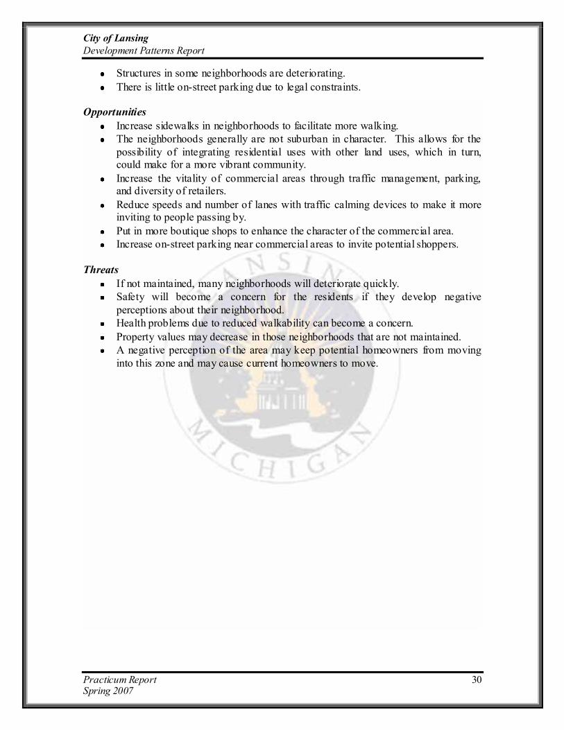
Structures in some neighborhoods are deteriorating.
There is little on-street parking due to legal constraints. Opportunities
Increase sidewalks in neighborhoods to facilitate more walking.
The neighborhoods generally are not suburban in character. This allows for the
possibility of integrating residential uses with other land uses, which in turn, could make for a more vibrant community.
Increase the vitality of commercial areas through traffic management, parking, and diversity of retailers.
Reduce speeds and number of lanes with traffic calming devices to make it more inviting to people passing by.
Put in more boutique shops to enhance the character of the commercial area.
Increase on-street parking near commercial areas to invite potential shoppers.
Threats
If not maintained, many neighborhoods will deteriorate quickly.
Safety will become a concern for the residents if they develop negative
perceptions about their neighborhood.
Health problems due to reduced walkability can become a concern.
Property values may decrease in those neighborhoods that are not maintained.
A negative perception of the area may keep potential homeowners from moving
into this zone and may cause current homeowners to move.

City of Lansing
Development Patterns Report
Practicum Report 31 Spring 2007
4.5 Zone 4
4.5.1 Description – Late 20th Century (1966 – Present)
The 1970s marked the start of the decline in the dominance of the automobile manufacturing
industry in the City. Existing trends from the post-war neighborhood period continue to dominate the current
construction of housing in Lansing. The distance between homes and lots are increasingly becoming larger and uses of land are continually being separated,
in part due to the increased amount of automobile use and due to the popularity of a suburban setting.
Architectural designs exhibit less articulation than previous zones. Very little integration of land uses is apparent in these neighborhoods, one car-width
driveways have transitioned into two car-width driveways, and street patterns are showcasing
curvilinear styles. This era also starts to show traffic management/calming elements such as cul-de-sacs, rotaries, and speed bumps.
4.5.2 Findings
Residential Areas
The residential neighborhoods in this development era have larger lots, typically ranging from 0.19 acres in the more compact
areas to 0.47 acres and larger in areas on the outer edge of this zone. The houses look nice
yet simple and are built with very little architectural articulation. Single family and multi- family units are mostly segregated from
each other into distinct areas. The houses have larger setbacks that range typically from 25 to
50 feet and housing structures are mostly one story slab foundation, ranch-style or two story colonial homes. Both styles having well defined entryways at the front of the house,
porches, and the majority of mailboxes are placed close to the street. The roofs are shallow pitched, and the building material for the houses is mostly horizontal siding.
Attached garages to the side and facing the front start to appear in this era. On-street parking is permitted in these areas and the presence of sidewalks is not uniform in all the neighborhoods. Trees and streetlights are predominant in many of the residential
neighborhoods. Most homes were well maintained with just a few exceptions.
Barren Drive

City of Lansing
Development Patterns Report
Practicum Report 32 Spring 2007
Commercial/Industrial Areas The commercial areas in this zone are
located mostly along major thoroughfares and are segregated from the residential
areas. The commercial structures are predominantly single story and have little articulation. Parking for commercial uses
are located primarily in the front of the structure, in the form of small to large
parking lots (depending on the character of the use), giving a larger front setback. Street widths are relatively large in most
residential areas which accommodate the permitted on-street parking, however, wide
streets without traffic calming devices can trigger faster traffic speeds. Commercial streets generally serve regional transportation needs and thus are generally five lanes wide with very limited pedestrian access or traffic
calming devices. Sidewalks in most commercial areas are present, although,
they are not continuous and since the front setbacks are pretty large and parking is located in lots in front of the structures, the
sidewalks are not of much use to shoppers. Industrial uses are segregated even further
into distinct areas/blocks. Most characteristics are the same between the commercial and industrial areas. Building
materials for these structures vary, with a majority of them being brick and cement
block pole barn structures. There is not much architectural articulation in the structures, roofs are mostly flat or shallow pitched, and entryways are simply defined.
Open Space
There are scattered parks/recreational areas and natural open spaces throughout the zone. Many residential neighborhoods and
subdivisions within the zone have a park or playground, with much of the public and
private natural open space located behind homes, abutting backyards to serve as buffers between other homes, streets or land uses. As
in the previous zone, larger parks and recreational areas are in this zone.
Cedar Street
Northrup Rd.
Edgewood Blvd.

City of Lansing
Development Patterns Report
Practicum Report 33 Spring 2007
Anomalies While the street and architectural form is
relatively consistent among the differing residential neighborhoods, some anomalies do
exist in street pattern and between housing units. A few residential areas have straight or grid pattern street design, instead of the
predominant curvilinear and cul-de-sac street pattern, although generally these street
anomalies have traffic calming devices such as speed bumps. Many houses in the Contemporary Neighborhood zone were built
prior to the assigned timeframe and thus offer different architectural styles, such as more
predominant porches, stronger articulation and steeper pitched roofs.
4.5.3 Strengths, Weaknesses, Opportunities, and Threats (SWOT) Analysis
Strengths
Many areas are very well kept neighborhoods.
Walkability is encouraged in a few neighborhoods with sidewalks.
Houses in a few neighborhoods have smaller setbacks, promoting a close-knit neighborhood.
Street lighting is present in most areas, promoting safety.
Very neat neighborhoods, with identical front setback and similar housing
structure, increased predictability and property values.
It is common to find both private and public open space.
There are relatively quiet neighborhoods due to traffic calming measures.
Trees on the streets enhance the positive aspects of most neighborhoods.
On-street parking is allowed in many neighborhoods.
Large lot sizes make it possible to expand structures that may raise the value o f
the property.
Large streets and driveways are available for the increasing amount of families
that own more than one vehicle.
Weaknesses
Lots are larger and houses that are separated from each other decreases
walkability.
Large setbacks depict isolation.
There is no integration of uses. Different uses are segregated into different areas.
There is little diversity in housing structures.
There are few multifamily structures, and a lack of low-income housing.
Residential architecture is simple and there is no articulation.
Large parking lots in front of commercial/retail buildings are not very inviting for pedestrians.
Edgewood blvd.

City of Lansing
Development Patterns Report
Practicum Report 34 Spring 2007
There is a high reliance on cars for basic travel needs.
There is reduced walkability due to the absence of sidewalks in some neighborhoods and few opportunities for active living (no sidewalks, no bike lanes, and no grocery stores with close proximity) exist.
Big box retailers are predominant in the area.
There is a lack of niche market retail stores and boutique shops.
The commercial strips are not inviting to the people as higher speeds on the roads
and more lanes reduce the curiosity of shoppers.
Opportunities
Building more sidewalks could lead to a more vibrant and walkable area.
Increase connectivity between different neighborhoods areas (i.e. trails, new
roads, pathways).
Use well-maintained neighborhoods as an example for less attractive place to
follow.
Develop small commercial centers close to suburban neighborhoods. Since the
main commercial centers have big box retailers, small shops and those catering to a niche market may not affect the large retailers too much.
Have new architectural design requirements for commercial buildings facing major roads (parking behind the building, patios, benches, trees, large shop windows).
Increase the vitality of commercial areas by improving signage, managing the traffic flow better, and bringing stores closer to the streets, instead of being tucked
away behind large parking lots.
Put in more boutique shops to increase the diversity of stores in the commercial
area.
Restructure existing commercial concentrations as walkable mixed-use centers.
Reduce speeds and number of lanes (by putting in medians, etc.) to make it more inviting to people passing by.
Extend the service area and routes provided by the local transit system.
Incorporate carefully designed multi- family residential uses within walking
distance of transit facilities.
Threats
If not maintained, many neighborhoods will start to deteriorate leading to decreased property values.
Pedestrian safety might be a concern for the residents in some neighborhoods without sidewalks.
Developers might be reluctant to develop mixed-use developments.
It might be inefficient to have transit service in certain areas.
City of Lansing
Development Patterns Report
Practicum Report 35 Spring 2007
Recommendations
The typical preparation process for a form-based code (LGC, 2004) starts with the inventory of the existing physical conditions. The analysis of the current patterns of development is a critical step that supports the following processes and especially the
community-visioning phase. While the community in general and each neighborhood in particular will decide specifically how their neighborhood would look like in the future,
several potential constraints and recommendations would assist planners and residents in their efforts to develop design guidelines for the City of Lansing.
Assumptions
Based on the socio-economic profile of the City of Lansing, and the form-based
study, the Practicum team has several assumptions that are critical in the creation of design guidelines. These conditions have a bearing effect on the nature and type of recommendations.
Any citywide or neighborhood specific plan should be based on citizen input and a community visioning process.
Different areas of Lansing have different functions. The downtown has a different role than a neighborhood; different areas serve distinct markets (neighborhood,
city, or regional). Neighborhood functions include: residential, school, markets, shops, gas stations, parks, and playgrounds.
Lansing will continue to be the capital of the state of Michigan and display a variety of functions: residential, commercial/ office, retail, industrial, education, open space, and entertainment. Lansing will continue to serve the region (i.e.
regional major retail and office centers).
The City‟s transportation system, both motorized and non-motorized, serves
various purposes: neighborhood, city, or regional market access.
The City of Lansing should have a comprehensive vision of its future (an adopted
revised master plan) but particular neighborhoods may have different approaches.
Shifts in the economic base sectors will continue in Lansing (i.e. decline of
manufacturing sector, growing IT-type sector).
Various federal and state programs are and will be available to help the city‟s
redevelopment efforts (i.e. historic preservation programs, Main Street Program).
Constraints
Lansing‟s revitalization efforts in the next years will be challenged by a series of conditions which, if identified early, may be integrated in the policy making process.
Some of these aspects may represent an impediment to short term or long-term redevelopment actions.
Budgetary constraints may continue to be a factor, considering the amount of
projects requiring substantial funding assistance.
Different stakeholders (i.e. council-members, state agencies) may oppose
redevelopment measures proposed by neighborhoods or the planning office.

City of Lansing
Development Patterns Report
Practicum Report 36 Spring 2007
Time constraints. Redevelopment takes time and continuous efforts from all
stakeholders.
Market forces. Population and economic shifts threaten Lansing‟s economy with constraints on short and medium term goals. Lack of interest from developers to
redevelop areas in Lansing and the perceived image of the city may have a negative impact on redevelopment efforts (i.e. young population, Cool Cities
survey).
Certain highways must serve regional markets and not neighborhood purposes.
Highways must provide people with easy access to downtown, office, and retail centers in order to have a healthy economic sector.
The city has numerous brownfield sites, large vacant or under-utilized industrial
areas. Because brownfield redevelopment is very expensive, this aspect may hinder the redevelopment of Lansing in the long term.
Lack of consensus on the redevelopment goals and actions may hinder the future development of Lansing. A master plan/ cluster plans and implementation action
plans are critical and may delay any redevelopment effort. These documents should be revised and updated regularly to adjust to social, economic, and
physical changes in the city. Citywide recommendations
While more development in the city is needed, clear planning documents and strategies, adopted through an open participatory process, must guide growth and
redevelopment towards achieving the community goals and vision. The new growth may range from simple renovations of particular properties to the extensive redevelopment of existing built areas, infill development or redevelopment of large vacant areas. Along
with private initiatives, the City of Lansing will engage in revitalization strategies and programs with pervasive effects on the physical, social, and economic fabric of the city.
In light of these considerations, we suggest design principles that aim at guiding the city officials and city staff in the decision-making process and in developing strategies and ordinances about redevelopment. The following three design principles
may serve as the foundation for the design guidelines to be developed in the Master Plan and for any other decisions affecting the physical, social, or economical aspects of the community.
All urban design strategies and projects should strengthen the identity of the
city as a whole and the image of each neighborhood. Under this principle, design strategies and guidelines should consider the overall legibility of the city. The city should have a well-defined image with distinct parts and well-designed paths. The physical
connectivity of all parts of the city is essential to the creation of a legible city. The transportation system, the underlying system for the proper functioning of the city,
encompasses the channels along which people move every day. Along with enhancing transportation links, the city should develop and enhance the place of intersection of these paths. Vibrant and meaningful nodes or strategic points, characterized by concentrated
attention, are vital for the image of the city (Lynch, 1960). The city components (the neighborhoods) should have a clear identifiable character with a gradual transition
City of Lansing
Development Patterns Report
Practicum Report 37 Spring 2007
between areas. Neighborhoods may gain stronger identity by use of landmarks that are highly visible and recognizable by residents and visitors as well.
Be aware of the physical context of each neighborhood and achieve greater
compatibility between uses. The City of Lansing displays a range of neighborhood patterns with distinctive development and architectural attributes. The visual and functional fit of the city and of its neighborhoods is strongly affected by the way different
kinds of uses and development densities, encountered in each neighborhood, interact. In light of these considerations, it becomes central that future developments should not
disrupt but enhance the legibility of the neighborhoods through high consistency with surrounding structures. Building proportions and materials are some of the aspects of concern in this regard. Neighborhoods should be cohesive and the transition between
distinct zones should be gradual and smooth to enhance the overall image of the city.
An adequate balance between walkability and automobile utilization. Connectivity refers to the way in which places and land uses are physically linked together. This aspect includes different means of transportation (i.e. streets and roads,
transit routes and stops, sidewalks and bike lanes) and their availability across the city. This principle refers to achieving a balance between competing modes and needs: the
need for „active living‟ opportunities and the need for rapid access to different parts of the city. Pre-World War II neighborhoods have sidewalks and a variety of uses in close proximity while many low-density areas in Lansing show a clear separation of uses and
high reliance on the automobile for basic needs. Market preferences for any of these types of neighborhoods should be clearly identified and incorporated in the community‟s
plans. While the physical inventory and neighborhood visioning sessions would suggest different levels of walkability and reliance on automobiles, each neighborhood and the city as a whole should strive to achieve a balance of different modes of transportation.
Based on the form-based process, assumptions, and constraints analyzed above,
we suggest several citywide design guidelines/recommendations that may be the basis for the City‟s development of the urban design chapter of the master plan. These recommendations involve both process-related actions and form-based proposals,
identified as potential short-(one year), medium-(two to five years), or long-term (more than five years) actions. While the former will assist city planners in their efforts to revise
the master plan, the latter represents the team‟ proposals, and may be altered through the community visioning meetings. The team developed recommendations for four types of uses: residential, commercial/retail, industrial, and open space.

City of Lansing
Development Patterns Report
Practicum Report 38 Spring 2007
1. Residential
a. Short-term
Develop a series of meetings and activities to gather input from the
community that typically includes: focus group meetings, workshops, charrettes, presentations, and public engagements exercises to develop a vision of the physical built environment of each neighborhood and the city as
a whole. The Neighborhood pattern book represents an appropriate instrument of
public participation as it contains the description of each neighborhood pattern, and highlights strengths and weaknesses.
This public participation process will identify the function(s) of each
neighborhood, and the purposes of each transportation corridor. Involve and strengthen all neighborhood associations.
Identify the architectural and development styles the neighborhoods were originally built upon.
Encourage infill developments to be highly integrated with the architectural
style of the surrounding parcels. Identify the most blighted and run-down houses in each neighborhood and
develop an assistance program to support or encourage owners in this regard. Require all new developments to provide for street lighting, trees, and
sidewalks on local roads.
Encourage all residents to follow the architectural style of their neighborhood to better preserve the character and history of the neighborhood when making
architectural improvements or when using infill development.
b. Medium-term
Based on the community visioning process, identify and define the character of each neighborhood. Then, develop urban standards (streets, blocks, land
uses, and building placement, height) and architectural standards (buildings and frontage typologies).
Preserve historically significant buildings. Lansing has several historic
districts and many beautiful pre-World War II houses that have a historic importance. Along with historical significance, these are community assets,
which play a central role in the city‟s efforts to increase attractiveness. Across the U.S., communities‟ development initiatives build on particular assets that help differentiate these communities. Historic preservation measures range
from requiring new development to clear architectural standards, achieving compatibility with surrounding properties, to encouraging property owners to
engage in renovation projects to bring back the historical appearance of an area.
Create incentives to protect and enhance small retail centers in highly
walkable neighborhoods. Encourage the improvement of CATA signage, shelters, and other bus stop
amenities for transit riders, to make it friendlier for existing and potential users, along main arterial roadways.

City of Lansing
Development Patterns Report
Practicum Report 39 Spring 2007
Build medians, bicycles lanes, and minimize pedestrian/automobile conflict points for transportation corridors used intensively by residents/pedestrians.
Encourage residents to engage in architectural improvements of their houses and landscaping of front lawns to enhance the visual appearance of the
neighborhood. Increase the identity of the neighborhood with entrance/exit signage that will
inform the visitor about the name of the neighborhood.
c. Long term
Preserve stable neighborhoods that exist in the older sections in Lansing. Strengthen all Lansing neighborhoods.
Encourage the development of mixed-use neighborhoods.
Increase the connectivity and accessibility of the City‟s neighborhoods.
2. Commercial/retail/Industrial.
Creating vibrant commercial/retail areas may represent an important overall goal
of the community. Design elements are central in revitalizing the numerous Lansing commercial areas located along major transportation corridors.
a. Short term
Create design guidelines for the Downtown district through a public
participation process. Involve the business owners and surrounding neighborhoods, state agencies, and city officials.
Conduct/hire consultants to conduct a commercial/retail analysis of Lansing. The study would identify hot spots with high potentials of growth or induced market demand. An induced demand may be a neighborhood shopping center
at the intersection of two major roads that would serve the basic needs of neighborhood within walking distance. These hot spots may be then
redeveloped or improved. Conduct charettes and workshops with industrial owners to identify their
needs.
Conduct charettes with surrounding neighborhoods to identify the residents‟ perspective on the industrial areas.
b. Medium-term
Encourage developers to build in areas serviced by the local transit system.
Encourage measures to enhance commercial strips/centers, making them more walkable or accessible.
Encourage businesses to provide convenient bicycle parking and locate them in convenient and visible areas.
Create buffers between industrial and residential areas.
c. Long-term
Promote the City as a regional commercial and retail destination.

City of Lansing
Development Patterns Report
Practicum Report 40 Spring 2007
Encourage commercial structures to be built/redeveloped closer to the street line to provide a strong visual and pedestrian relationship to the street (for
designated areas). Promote infill development for vacant or underutilized strip commercial
property that promotes mixed-use design, alternative modes of transportation and connectivity to nearby residential neighborhoods.
Encourage the redevelopment of vacant industrial properties (i.e. brownfield
redevelopment).
3. Open space.
An overall goal of the community may be to encourage the development of more
parks and playgrounds. A vibrant community needs a safe and accessible place to gather and interact. Lansing has several parks, playgrounds, and open spaces.
However, public places should be encountered in each neighborhood, from civic plazas in the core urban areas to neighborhood parks and open spaces in its districts. A well-designed and used park enhances the image of the area contributing to the
overall quality of life of the Lansing residents.
a. Short term: Organize charettes or surveys to identify residents‟ needs with regard to the
availability of parks and playgrounds in their neighborhood. Conduct a study
of downtown existing plazas and parks and identify market demands for such facilities.
Develop an inventory of existing sidewalks, trails, and greenways connecting the neighborhoods.
Identify feasible places to develop bike lanes.
b. Medium-term
Build bike lanes on several major corridors ensuring the connectivity of these paths with other trails or shopping/working destinations.
Improve downtown open spaces/plazas (i.e. more amenities).
Develop parks or improve the existing ones based on the community vision.
c. Long-term
Enhance the waterfront. Encourage more development along the Grand River in Lansing. The river is where the historical areas of Lansing were built on,
and is severely underutilized in most parts of Lansing. The river should be the focal point of the city. These areas should become available and they need to
be “public use”.

City of Lansing
Development Patterns Report
Practicum Report 41 Spring 2007
Conclusions
In the process of updating its Master Plan, the City of Lansing needs a thorough inventory of its physical and economic base due to the significant shifts in the economic sector and population in the last decade. The Master Plan will include goals and
principles that will relate to the physical characteristics of the city and the socio-economic analyses will underlie redevelopment strategies in various sectors.
The Practicum Group has conducted an extensive field survey of the entire City of Lansing, MI. The focus of this investigation was on the variations in the physical attributes of the Lansing neighborhoods as a result of different development eras. All
these initiatives must be guided to be conforming, and help make the city vision a reality. Also, the City of Lansing will engage in revitalization strategies and/or policy making
that will impact the physical, social and economic fabric of the city. This Practicum report provides the City of Lansing with an in-depth analysis on two
important topics of the community‟s Master Plan. The socio-economic analysis provides
a complete community profile of the city, highlighting the current situation and future trends that would help in the visioning phase of the revision process. The Form-based
study provides a complete analysis of the physical aspects of Lansing‟s neighborhoods. The SWOT analysis contains information on the current status of each neighborhood pattern in Lansing, highlighting what are the positive and negative aspects of each
neighborhood zone. Based on these analyses, the recommendations in this report provide design guidelines for the City of Lansing applicable to future redevelopment projects in
order to make Lansing an attractive place to live and work. The Practicum team hopes that the report will be very useful to our Client, the Lansing Planning Office, in their Master Plan revision process. Mayor Bernero, in his “2007 State of the City” address
mentions that “Good, is not good enough for Lansing…”, we hope this effort is useful to the City in achieving its goals for the future.

City of Lansing
Development Patterns Report
Practicum Report 42 Spring 2007
References
Burdette, Jason T. (2004). Form-Based Codes: A Cure for the Cancer Called Euclidean Zoning? Thesis, Master of Urban and Regional Planning, Blacksburg, VA, retrieved February 21, 2007 from http://scholar.lib.vt.edu/theses/available/etd-05122004-
113700/unrestricted/BurdetteFINALmajorpaper.pdf
Carroll County, MD. (2006). “Pathways to Carroll‟s future landscape”. Retrieved
February 23, 2007 from http://www.carrollpathways.org/
FBC www.formbasedcodes.org, retrieved February 20, 2007. Guy, Andy (2003). City Hall, Get Me Re-Write! Innovative Grand Rapids designs
require new development playbook. August 17, 2003. Retrieved on February 15, 2007 from http://www.mlui.org/growthmanagement/fullarticle.asp?fileid=16536
Local Government Commission (LGC). (2003). Overcoming Obstacles to Smart Growth through Code Reform. An executive summary of A Smart Growth Zoning Codes: A Resource Guide, retrieved February 19, 2007 from
http://www.lgc.org/freepub/PDF/Land_Use/sg_code_exec_summary.pdf
Lynch, K. (1960). The Image of the City. Cambridge [Mass.] Technology Press
Peirce, N. (2003, Feb. 5). Zoning: Ready to be Reformed? The Washington Post Writer’s Group. Retrieved February 20, 2007 from http://www.postwritersgroup.com/archives/peir0127.htm
Peirce, N (2003). A Cure For Cluttered Roadways? The Washington Post Writer’s Group. Retrieved February 20, 2007 from
http://www.postwritersgroup.com/archives/peir0616.htm
Place Makers, www.placemakers.com
Realtor.org. „Zoning Reform Has Begun: Form-Based Codes‟, retrieved on February 18,
2007 from http://www.realtor.org/SG3.nsf/Pages/formbasedcodes?OpenDocument .
Zone Grand Rapids, 2004. Retrieved on January 15, 2007 from http://www.ci.grand-
rapids.mi.us/index.pl?page_id=2659
City of Petaluma website http://cityofpetaluma.net/cdd/cpsp.html

City of Lansing
Development Patterns Report
Practicum Report 43 Spring 2007
Appendix
Appendix I

City of Lansing
Development Patterns Report
Practicum Report 44 Spring 2007
Appendix II
Neighborhood Pattern Assessment Criteria
Criteria Zone:
Development era: year built
Central city
Along major transportation corridors? Streetcar
Post WWII
Suburban
Block size
Smaller blocks: 400 ft or less
Medium sized blocks 400-600ft
Large blocks 600ft or more
Super- large blocks 1/2 -1 mile
Houses with large sq. footage?
Street pattern
Grid
Curvilinear
Cul-de-sacs
Land use patterns
a) Neighborhood Use Patterns
high integration of residential and non-residential uses
reduced integration of residential and non
residential uses
little/no mix of uses
some integration of multi- family into single-family residential areas
multi- family separated from single-family
non-residential uses segregated in a larger area
non-residential uses located along a major street
b) Building uses
mixed-use - vertical
Residential
office/civic

City of Lansing
Development Patterns Report
Practicum Report 45 Spring 2007
Retail
commercial
Industrial
Lodging
c) Available open space
Parks/Playground
Plaza
Natural areas
Lot Characteristics
Lot width
Lot coverage (%)
Coverage of front property line
Public Frontages
Street
Road
Boulevard
Alley
Front setback
deeper front setbacks
Multi- family
Single family
wealthier areas
Parking
on-street parking - both sides
on-street parking - one side
Garage – detached
Garage – attached
Carports
parking screened by buildings
Driveway
Architectural Patterns
Building height
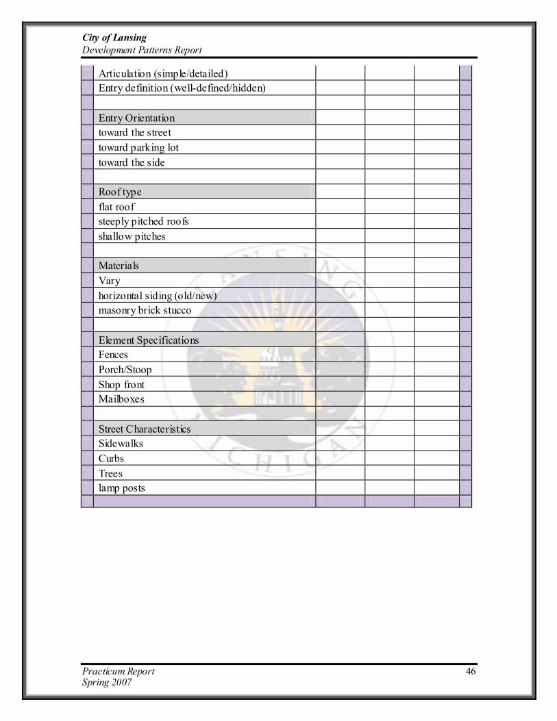
City of Lansing
Development Patterns Report
Practicum Report 46 Spring 2007
Articulation (simple/detailed)
Entry definition (well-defined/hidden)
Entry Orientation
toward the street
toward parking lot
toward the side
Roof type
flat roof
steeply pitched roofs
shallow pitches
Materials
Vary
horizontal siding (old/new)
masonry brick stucco
Element Specifications
Fences
Porch/Stoop
Shop front
Mailboxes
Street Characteristics
Sidewalks
Curbs
Trees
lamp posts

City of Lansing
Development Patterns Report
Practicum Report 47 Spring 2007
Definitions for the above Checklist:
Development patterns refer to elements of the neighborhood and streets, influenced by different development approaches over the decades. These include the
following aspects: - “Development era” refers to the nature of development according to year-built
classifications (i.e. central city, streetcar, post World War II, suburban). “Block size” is
defined as taking several values for the dimension of the block. “Street pattern” involves three distinct types: grid, curvilinear, and cul-de-sacs.
- “Neighborhood use” patterns refer to the integration of uses between residential and non-residential uses, and between single-family and multi- family units. “Building use” identifies the function of the structure (i.e. residential, commercial, retail,
industrial, lodging, or mixed-use) and “Open space” involves different categories within a neighborhood (i.e. parks, playgrounds, plazas, natural areas).
- “Lot characteristics” look at lot width, lot coverage, front setbacks, and coverage of front property line. “Public frontage” refers to the type of road the building faces (i.e. street, road, boulevard, or alley). “Parking” refers to the location of parking
and dimension of the parking garage.
Architectural patterns refer to the characteristics of the buildings, including building height, and the following architectural aspects:
- “Building articulation” refers to whether a building has simple or detailed
articulation (i.e. the degree of architectural detail of the façade, balconies, windows, corners, colors, and texture). “Entry definition” refers to how well defined or hidden the
entrance is. “Entry orientation” refers to whether the orientation of the entrance is toward the street, parking lot or to the side.
- “Roof type” may be flat, steeply pitched, or shallow pitched. “Building
materials” may be horizontal or vertical siding, masonry or stucco, or a combination. - “Element specifications” refer to whether dwellings have fences, stoops, or
porches, the nature of the shop front, and where mailboxes are placed. “Street characteristics” refer to whether sidewalks, curbs, trees, and streetlights are present on a particular street.

City of Lansing
Development Patterns Report
Practicum Report 48 Spring 2007
Appendix III
See attached Field Survey Data Sheets