Embed Size (px)
Citation preview

Commissioned Research Report on the
Senkaku Islands-related Documents
FY2016 Cabinet Secretariat Commissioned Research ProjectMarch 2017 Streamgraph Inc.
Senkaku Islands-related DocumentsCommissioned Research Report on the
FY2016 Cabinet Secretariat Commissioned Research ProjectMarch 2017 Streamgraph Inc.

Preface
Project Outline
1. Project Objectives and Summary
2. Periodization
3. Project Scheme and Schedule
4. Source Institutions and Surveyed Materials
5. Research Results
6. (1) Exemplar Documents 1 ( Prior to the Territorial Incorporation )
(2) Exemplar Documents 2 ( The Territorial Incorporation – the end of WWII )
(3) Exemplar Documents 3 ( After World War II - Okinawa’s Reversion to Japan )
(4) Exemplar Documents 4 ( The U.S. Government Documents after World War II )
(5) Exemplar Documents 5 ( Foreign Countries’ Perception )
Afterword (Research Team)
0203030405070809
11
16
32
35
39
Table of Contents
Commissioned Research Report on the Senkaku Islands-related Documents ... 02
Preface This project aims to research and collect various documents and materials related to the Senkaku Islands, with the ultimate goal of organizing them into a catalogue and database of digitized images. This is because we believe that it is important for the discussion on the Senkaku Islands to be logically approached, relying on fact-based historical recognition of the Islands. This fiscal year, we were able to research the source institutions painstakingly in Okinawa, Kyushu, and Tokyo, and succeeded in collecting the relevant materials. Among them, there are the Yokouchi Family Documents, archived at the Naha City Museum of History, that contain many invaluable materials. We would like to express our deepest gratitude for the kind consideration paid by the Museum that enabled us to use the Documents in this project. Chinese materials such as “Daimin-Ittoshi (Da Ming yi tongzhi)” (Records of the Unity of the Great Ming (The Imperial Geography of the Ming Empire)) and “Daishin-Ittoshi (Da Qing yi tongzhi)” (Records of the Unity of the Great Qing (The Imperial Geography of the Qing Empire)) were also examined in this project in order to understand the pre-modern situation of the Senkaku Islands, before their incorporation into Japanese territory. Moreover, we took examples of highly valuable descriptions on the Senkaku Islands from numerous genealogy tables or family lineages complied during the Ryukyu Kingdom period.
Among our findings was an article referring to the incident in which a ship belonging to Satsuma drifted ashore on the Senkaku Islands in 1819. Choei NAKIJIN (Kōki SHO / Xiang hong ji in Chinese pronunciation), an official of the Ryukyu Kingdom, was on board on his way to Kagoshima for official trip. The island, one of the Senkaku Islands, referred to in the article as “commonly called Yokon-kobajima.” The accumulation of these works gradually sheds light on the reality concerning the Senkaku Islands over a period of history; the reality includes: the actual situations of pre-modern times and the time of territorial incorporation, the situations of the prefectural areas of Okinawa after the Senkaku Incorporation and the post-war period under the U.S. administration, which led to the situation of the Okinawa’s reversion to Japan. In order to delve deeper into these findings, we need to keep on researching and collecting the relevant materials, and organize the information obtained from these efforts. An enormous amount of documents has been compiled through the projects we have been working on. The distinctive research results achieved this fiscal year are presented in this report, in the hope of enabling many people to know the importance of our work, and at the same time of sharing the significance of fact- and logic-based historical recognition.
Chair of the Research Committee for the Researchon the Senkaku Islands-related Documents
Kurayoshi TAKARA
Cover Image: Photo by Takumi MIYAZAKICourtesy of Takafumi SASAKI Laboratory,Faculty of Fisheries, Kagoshima University
Project Outline
Project Objectives and Summary1 In FY 2016, in cooperation with the Okinawa Peace Assistance Center (OPAC), Streamgraph Inc. undertook a project entitled “Research on the Senkaku Islands-related Documents” commissioned by the Office of Policy Planning and Coordination on Territory and Sovereignty, Cabinet Secretariat. With the purpose of contributing to further study and understanding on the subject, this project aims to catalogue and compile digitized images of major materials on the Senkaku Islands archived in Japan. The timeframe of the research primarily focused on the periods from 1885, prior to the territorial incorporation of the Senkaku Islands, to 1972 (the reversion of Okinawa) . In this project, a Research Team, mainly made up of local experts, conducted the research, collection, and digitization of the documents and materials. In addition, the Research Committee consisting of academic experts was set-up to provide guidance and counsel to the Research Team. Given that the project was carried out in a limited one-year period, the research results should not be regarded as comprehensive. Under the Research Committee’s guidance, the Research Team collected and selected the documents and materials, and compiled this report. Therefore it should not be construed as representing the views of the Government of Japan.
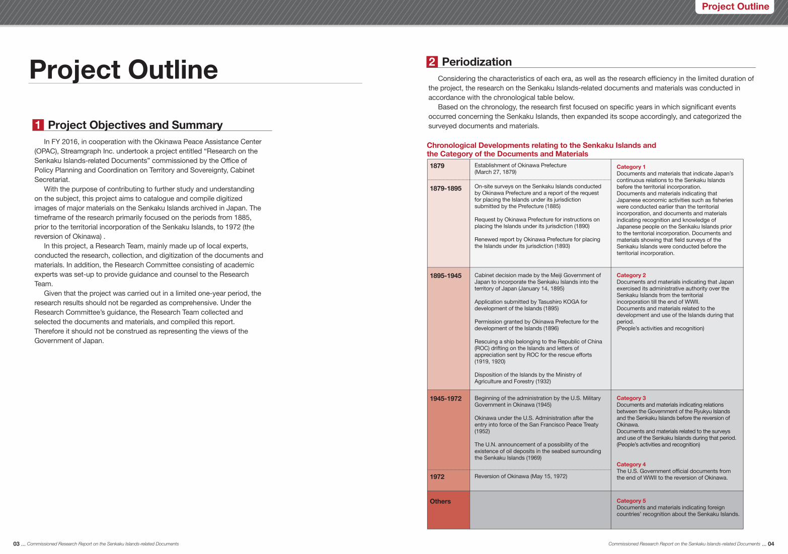
Periodization2 Considering the characteristics of each era, as well as the research efficiency in the limited duration of the project, the research on the Senkaku Islands-related documents and materials was conducted in accordance with the chronological table below. Based on the chronology, the research first focused on specific years in which significant events occurred concerning the Senkaku Islands, then expanded its scope accordingly, and categorized the surveyed documents and materials.
1879
1879-1895
1895-1945
Chronological Developments relating to the Senkaku Islands and the Category of the Documents and Materials
Establishment of Okinawa Prefecture (March 27, 1879)
On-site surveys on the Senkaku Islands conducted by Okinawa Prefecture and a report of the request for placing the Islands under its jurisdiction submitted by the Prefecture (1885)
Request by Okinawa Prefecture for instructions on placing the Islands under its jurisdiction (1890)
Renewed report by Okinawa Prefecture for placing the Islands under its jurisdiction (1893)
Cabinet decision made by the Meiji Government of Japan to incorporate the Senkaku Islands into the territory of Japan (January 14, 1895)
Application submitted by Tasushiro KOGA for development of the Islands (1895)
Permission granted by Okinawa Prefecture for the development of the Islands (1896)
Rescuing a ship belonging to the Republic of China (ROC) drifting on the Islands and letters of appreciation sent by ROC for the rescue efforts (1919, 1920)
Disposition of the Islands by the Ministry of Agriculture and Forestry (1932)
Category 1Documents and materials that indicate Japan’s continuous relations to the Senkaku Islands before the territorial incorporation. Documents and materials indicating that Japanese economic activities such as fisheries were conducted earlier than the territorial incorporation, and documents and materials indicating recognition and knowledge of Japanese people on the Senkaku Islands prior to the territorial incorporation. Documents and materials showing that field surveys of the Senkaku Islands were conducted before the territorial incorporation.
Category 2Documents and materials indicating that Japan exercised its administrative authority over the Senkaku Islands from the territorial incorporation till the end of WWII. Documents and materials related to the development and use of the Islands during that period.(People’s activities and recognition)
1945-1972
1972
Others
Beginning of the administration by the U.S. Military Government in Okinawa (1945)
Okinawa under the U.S. Administration after the entry into force of the San Francisco Peace Treaty (1952)
The U.N. announcement of a possibility of the existence of oil deposits in the seabed surrounding the Senkaku Islands (1969)
Reversion of Okinawa (May 15, 1972)
Category 3Documents and materials indicating relations between the Government of the Ryukyu Islands and the Senkaku Islands before the reversion of Okinawa. Documents and materials related to the surveys and use of the Senkaku Islands during that period.(People’s activities and recognition)
Category 4The U.S. Government official documents from the end of WWII to the reversion of Okinawa.
Category 5Documents and materials indicating foreign countries’ recognition about the Senkaku Islands.
03 ... Commissioned Research Report on the Senkaku Islands-related Documents Commissioned Research Report on the Senkaku Islands-related Documents ... 04
Project Outline

Project Outline
The project established a Research Committee consisting of Japanese experts from various fields such as international law, international politics, and local history. In this project, a Research Team was organized as well, and the team researched and compiled the documents and materials in consultation with the Research Committee.
Project Scheme and Schedule3 Research Chronology
July-September 2016
- Preliminary research was conducted, and the research plan was laid out.- The 1st meeting of the Research Committee was held on July 8, and the research plan
was confirmed.- Research was conducted at the institutions in Okinawa, such as the Okinawa
Prefectural Archives, the Okinawa Prefectural Library, and the Okinawa Prefectural Assembly Library.
- Research was conducted across Japan on materials indicating foreign countries’ perception (Document Category 5).
October - November
- Document research continued with a focus on relevant institutions and individuals, and documents once surveyed were organized.
- Preliminary research at the National Diet Library (Modern Japanese Political History Materials Room) was conducted.
- Based on the research results, the 2nd meeting of the Research Committee was held on November 22. The research progress report was made, issues and tasks were sorted out, and the priority subjects of the research were discussed.
- Digitized images of documents and materials archived at the Okinawa Prefectural Archives and the Okinawa Prefectural Assembly Library were created.
December - Additional research was conducted.- Digitized images of documents and materials archived at the Okinawa Prefectural
Library were created.- Researchers visited the Naha City Museum of History concerning the research on the
documents and materials archived at the Naha City Museum of History, and related materials were confirmed.
- Catalogue of the surveyed documents and materials was created.
January-February 2017
- The Yokouchi Family Documents at the Naha City Museum of History and other genealogy documents at Okinawa Prefectural Library were researched, and some of these documents’ images were digitized.
- Research was conducted at other institutions in Kyusyu area and the National Diet Library (Modern Japanese Political History Materials Room).
- Document catalogue and a draft of this report were created.- The 3rd meeting of the Research Committee was held on January 22. Members
verified additional research results, exchanged views on the draft of this report, and summarized the research results.
March - Document catalogue was created, and a draft of the Senkaku Islands-related document collection was drawn up.
- This report was finalized, and the project of this fiscal year was completed.
Research Team
Nozomu ISHII Associate Professor, Nagasaki Junshin Catholic University: Special ResearcherJun KAWASHIMA Researcher, Hosei University Institute for Okinawan Studies: ResearcherMakomo KUNIYOSHI Senkaku Islands Document Material Compilation Association: Chief ResearcherIkue MOTOMURA Researcher, Hosei University Institute for Okinawan Studies: Researcher
Research CommitteeMembers
Yuji UESUGIProfessor, Faculty of International Research and Education, Waseda University (Peace building and conflict resolution)
Fujio UEDAProfessor Emeritus, Okinawa University(Fishery economics, History of Okinawa’s fishery)
Kurayoshi TAKARAProfessor Emeritus, University of the Ryukyus (Okinawan history)(*Head of the Committee)
Secretariat Okinawa Peace Assistance Center(OPAC: Reiji FUMOTO)
Jun TSURUTAAssociate Professor, National Graduate Institute for Policy Studies(International Law)
Satoshi HIRANOProfessor, Faculty of Law, the University of Tokyo(Asian political and diplomatic history)
Fusaaki MAEHIRAProfessor, Faculty of Education, University of the Ryukyus(History of transportation and trades in modern East Asia)
Chisako MASUOAssociate Professor, Graduate School of Social and Cultural Studies, Kyushu University(Chinese Politics, International relation in East Asia)
Yasuhiro MATSUDAProfessor, Institute for Advanced Studies on Asia, the University of Tokyo(International Politics, Japan-China and Japan-Taiwan relations)
05 ... Commissioned Research Report on the Senkaku Islands-related Documents Commissioned Research Report on the Senkaku Islands-related Documents ... 06
The 3rd meeting of the ResearchCommittee on January 22
Hiroyuki OSAKI Streamgraph Inc.: Project Manager *Secretariat
*Alphabetical Order
*Alphabetical Order

Project Outline
Institution possessingrelative documentsand materials
Collected documents and materials
The University of Tokyo(Institute for Advanced Studieson Asia)
Daimin-Ittoshi (Da Ming yi tongzhi )(Records of the Unity of the Great Ming (The Imperial Geography of the Ming Empire)), etc. (Documents and Materials on foreign countries’ perception)
Privately owned Photo album with pictures of Zenji KOGA
Okinawa PrefecturalArchives
Documents and materials related to the attack against Daisan Seitoku-maru (Minutes of the Legislature of the Government of the Ryukyu Islands) (Documents on the investigation progress and petitions)Documents and materials related to Daisuke TAKAOKA’s visit to OkinawaDocuments and materials on academic survey plansPetroleum exploitation related materialsDocuments and materials on fishing ground surveys and reportsDocuments and materials related to designated bombing ranges (Official documents of the United States Civil Administration of the Ryukyu Islands (USCAR))Maps (Complete map of Okinawa, etc.)Documents and Materials related to the resolution on territorial defense, etc.
Okinawa PrefecturalLibrary
A collection of regulations including prefectural ordinances that ordains where Uotsuri and its neighbouring islands belong to (Okinawaken Reitatsu Ruisan (Collection of Okinawa Prefectural Ordinances and Notices))Publications of the Government of the Ryukyu Islands (Joho No.25)Academic survey reports of the University of the RyukyusDocuments and materials on post-war surveys and statistics (Ryukyu Yoran [Outlines of Ryukyu]) The Okinawa Biological Society MagazineNews letters issued by Biological Society of Okinawa BulletinMaterials created by the Self-Defense Forces (Okinawa Handbook)Maps created by the U.S. military (Copies of materials in possession of the United States Library of Congress) Notes and correspondence letters on serialized newspaper articlesRecords of the Ryukyu lineage (Record of the Gushikawa Family), etc.
Naha City Museumof History
A collection of regulations including prefectural ordinances that ordains where Uotsuri and its neighbouring islands belong to (Collection of Okinawa Prefectural Ordinances and Notices: the Yokouchi Family Documents)Documents and materials related to use and development of Uotsuri and Kuba islands (A petition submitted by Tatsushiro KOGA: the Yokouchi Family Documents)Maps (the Yokouchi Family Documents)
Okinawa PrefecturalAssembly Library
Documents and materials related to the attack against Daisan Seitoku-maru (Minutes of the Legislature of the Government of the Ryukyu Islands)Documents and materials related to weather station facilities (Committee meeting minutes of the Legislature of the Government of the Ryukyu Islands)Experimental fisheries-related materials (Minutes of the Okinawa Prefectural Assembly)News letters issued by Biological Society of Okinawa Bulletin, etc.
Research Results5Source Institutions and Surveyed Materials4
Institution possessingrelative documentsand materials
Collected documents and materials
National Archivesof Japan
Daishin-Ittoshi (Da Qing yi tongzhi)(Records of the Unity of the Great Qing (The Imperial Geography of the Qing Empire)), etc. (Documents and Materials on foreign countries’ perception)
Approx. 200 of official documents and approx.130 of news articles and other materials were surveyed, and a catalogue and digitized images of these documents and materials were created.
We confirmed that approximately 330 of the Senkaku Islands-relateddocuments and materials were located in Okinawa, Kyusyu and Tokyo,and then created their catalogue and digitized images.
“The Genealogy of the Gushikawa Family, the head family of the Sho Clan lineage” that indicates that Kōki SHO, a member of the royal family in the Ryukyu Kingdom era, landed on the Senkaku Islands when he was shipwrecked. (See Exemplar Document 1)
(a) Documents and materials that indicate Japan’s continuous relations to the Senkaku Islands before the territorial incorporation
The U.S. Military Government notifications prohibiting the local residents from entering the U.S. military gunnery and bombing ranges established on the Senkaku Islands soon after the war ended. (See Exemplar Document 4)
(d) The U.S. Government official documents from the end of WWII to the reversion of Okinawa
Government-made records/geography indicating that the Ming and Qing dynasties regarded the Senkaku Islands as outside their territorial domain (See Exemplar Document 5)
(e) Documents and materials indicating foreign countries’ recognition about the Senkaku Islands
Materials indicating that the Government of the Ryukyu Islands handled the case of an attack against a Japanese fishing ship, Daisan Seitoku-maru, occurred in Japan’s territorial waters near the Senkaku Islands (Uotsuri Island) in 1955. Materials on Tatsushiro KOGA’s son, Zenji Materials on the field surveys of the Senkaku Islands in 1968 led by Daisuke TAKAOKA, a specialist member of the Okinawa Mondai tou Kondankai [the consultative committee for the Okinawa issues], and on the comprehensive scientific survey of the Senkaku Islands conducted by the University of the Ryukyus in 1971. (See Exemplar Document 3)
(c) Documents and materials indicating relations between the Government of the Ryukyu Islands and the Senkaku Islands before the reversion of Okinawa
Documents and materials showing the request from the Tatsushiro KOGA, who was permitted to develop the Senkaku Islands by the Okinawa Prefecture in 1896, for Osaka Shosen Kabushiki Kaisha [Osaka mercantile steamship inc.] to make a port call at the Senkaku Islands on its Taiwan-Okinawa sea route in 1897. Prefectural Ordinance No.49 dated December 3, 1902 that determined the administrative district, still in effect today, to which the Senkaku Islands belong. (See Exemplar Document 2)
(b) Documents and materials indicating that Japan exercised its administrative authority over the Senkaku Islands from the territorial incorporation till the end of WWII
07 ... Commissioned Research Report on the Senkaku Islands-related Documents Commissioned Research Report on the Senkaku Islands-related Documents ... 08
In this project, institutionally- or privately-owned documents and materials were researched. Their sources and surveyed documents and materials are shown in the table below.
*In no particular order

Sho-sei Gushikawa-ke Kafu (Record of the Gushikawa Family, a branch of the Sho Family) Juni-sei Kōki (12th Family Head: Kōki SHO)
1Exemplar Documents 1 ( Prior to the Territorial Incorporation )6
Keizu and Kafu in Ryukyu
In 1689, the Ryukyu Kingdom created the “Keizu-za” as an administrative body and started to compile “Keizu” formally. Keizu formed the basis of the class system, and represented the status of an individual; those with Keizu were called “Kei-mochi (a Keizu holder)” (= “Shizoku [warrior]”) and those without were called “Mu-kei (a non-Keizu holder)” (= “Heimin [civilian]”). Keizu documents submitted by families to the Keizu-za were thoroughly inspected by officers. Passing documents were approved with an official seal of the Kingdom, with one copy kept in the Keizu-za and another copy kept in each household. With each generational change in the household, a new draft was submitted to amend the existing chart, and this procedure was repeated. Keizu were not treated as private documents, but as valuable official records in the Ryukyu Kingdom. It is assumed that during the Kingdom Era there were approximately 3,000 Keizu existing in the Shuri and Naha areas of the Okinawan mainland. The front cover of each Keizu displays the surname of the family and indicates whether it is a head family or a branch family. The contents were divided broadly into two parts: the Keizu with the family’s historical lineage (also called “Sekeizu”), and the Kafu with the history and work history of the successive heads and their family members. Therefore, the official name of these documents was the “Keizu-Kafu.” “Keizu” and “Kafu” are abbreviations of “Keizu-Kafu.” The “Keizu-Kafu” are documents critical to the research of the history of Okinawa and the Ryukyu Kingdom, with many published research papers referencing these records. (Kurayoshi TAKARA)
Notes/Explanations
This ship was a Satsuma ship carrying the Ryukyu royal family from Naha to Satsuma to attend an official party to celebrate the appointment of the lord of the Satsuma Domain in 1819. The ship drifted away in a gale from Iōtori-shima Island, the northern tip of Ryukyu, and reached “Yokon-kobajima Island (魚根久場島).” (This is the oldest record of the name of the island. The character “魚” is the Okinawan dialect “yo” for the archaic word “iwo,”, and “根” is the Okinawan dialect “kun” or “kon” for “kuni” [according to Masamori MIYANAGA].) Due to the lack of reference to islands on which to seek refuge and the description that the ship drifted to Yonaguni Island, it is thought that Yokon-koba Island refers to one of the Senkaku Islands. Considering that they were looking for fresh water for three days in the Senkaku islands, they must have landed on the island. There is no doubt that this was the oldest record of landing on the Senkaku Islands, 26 years earlier than the British landing of 1845. Kōki SHO (Choei NAKIJIN) was a Ryukyu royal family, and this could be considered the oldest official inspection of the island by a royal family member. The hill from which the officers waved their hands and flags at Yonaguni Island to guide the ship which had been drifted from the north, can be geographically assumed to be Tendabana of the Sonai Port. There is a rock called “Holland Rock” on Yonaguni Island, which was said to have been used to moor Dutch (and other western) ships. Judging from the many drifting records during the Edo Period, locals were accustomed to welcoming drifting ships. From the description of being told the name of Yokon-koba Island, it can be assumed that many ships which drifted in storms reached Yonaguni Island after spotting the Senkaku Islands.
(September 1819 in lunar calendar) On the 17th, as the weather finally cleared up, we saw a tall island but weren’t sure what it was called. (We later learned that it was called “Yokon-kobajima Island [魚根久場島]”). On the 18th, we sailed to this island and anchored at an inlet to get some fresh water, but unfortunately could not find any springs. There we waited for a sailing wind for three days. Suddenly, a storm struck. Everything, including the anchor and ropes, was lost in the waves. The ship was left to drift in the wind. People on board were praying for divine assistance. Fortunately, we saw another tall island on the 23rd. On the 24th, we gradually got closer to the island. There was a person on top of the island waving to our ship. (He was Jinya ASATO, an officer of Ishigaki Island). Five or six other people were waving flags, indicating an inlet. When a ship officer yelled to ask the name of the place, they replied “Yonaguni Island.”
09 ... Commissioned Research Report on the Senkaku Islands-related Documents Commissioned Research Report on the Senkaku Islands-related Documents ... 10
Date CreatedAuthor(s) & Editor(s)PublisherName of Publication
LanguageMediumPublic AccessRepositoryReference & Information
Classical ChinesePaperAvailable to the publicOkinawa Prefectural LibraryAvailable at the Okinawa Prefectural Library
Naha Shishi (The History of Naha)References Vol.1 No.7(Sho-sei Kafu Taiso Imina Shōi)
Overview
Despite the use of the Senkaku Islands as a marker point when sailing between Ryukyu and Fuzdhou since ancient times, there are hardly any written records of the islands. The Senkaku Islands are uninhabited islands in the ocean which were seldom mentioned when naval journeys were successful. However, Keizu-Kafu sometimes recorded episodes such as incidents of shipwreck and castaway situations on the islands causing by unexpected bad weather. The following Keizu-Kafu is an example of such a reference to the islands.
Excerpt [English translation]
(Edited/Interpreted by Nozomu ISHII)
1Exemplar Documents

s51109
On the matter of requesting for making a port callat Kuba Island from Tatsushiro KOGA:Letter dated January 19, 1899, from Shigeru NARAHARA, the Okinawa Prefectural Governor, to Tokugoro NAKAHASHI, the President ofOsaka Shosen Kabushiki Kaisha (Osaka mercantile steamship inc.)
2
11 ... Commissioned Research Report on the Senkaku Islands-related Documents Commissioned Research Report on the Senkaku Islands-related Documents ... 12
Drafted on January 19, 1899Along with a request to the president of Osaka Shosen Kabushiki Kaisha inc., I would like to ask you a ship course plan of Tatsushiro KOGA as follows:
Dear Mr. NAKAHASHI,
I hope this letter finds you well. Kuba Island and Uotsuri Island located within Yaeyama Islands in Okinawa have remained uninhabited and unexplored; however, since a civilian named Tatsuhiro KOGA living at 23 Aza-Nishi, Naha-ku, Okinawa submitted a land lease and development request, I granted him permission in August 1896. He has managed to hire a steamer once or twice, and planned to visit the islands with a dozen fishermen and farmers. Both islands (Kuba and Uotsuri) are fertile, and I believe developing the land would serve the best interests of Japan. However, the islands are isolated and transportation to them is extremely inconvenient, so he cannot execute the project as he would expect. Hiring a steamer for every visit is too expensive and is unsustainable. He reached the conclusion that the only and best solution is to request a favour from your company (Osaka Shosen Kabushiki Kaisha), and thus he asked me to contact you. Tatsushiro wishes to personally ask you as well, so please ask him for any details which may help him achieve his goals.
Sincerely,
Shigeru NARAHARA
January 19, 1899
(Edited/Interpreted by Jun KAWASHIMA & Ikue MOTOMURA)
Date CreatedAuthor(s) & Editor(s)
PublisherName of PublicationLanguageMediumPublic AccessRepositoryReference & Information
[January 19, 1899][Shigeru NARAHARA (Governor ofOkinawa Prefecture) / handwrittencopy by Tasuku YOKOUCHI]
Document [6827]JapanesePaperAvailable to the public (copy)Naha City Museum of HistoryTo follow the instructionat the Naha City Museum of History
Exemplar Documents 2 ( The Territorial Incorporation – the end of WWII )6
The Yokouchi Family Documents
The “Yokouchi Family Documents” owned by the Naha City Museum of History is a collection donated by the family of Tasuku YOKOUCHI to the Naha Historical Materials Office (currently the Naha City Museum of History) after his death. It contains 18,000 documents (“Yokouchi Family Documents”) and 3,000 fine arts and crafts. The following is a brief overview of the “Yokouchi Family Documents:” The Yokouchi Family had been working for the Ii Family as feudal retainers of the Hikone Domain during the Edo Period, and the 9th head of the family, Tasuku YOKOUCHI, became an Okinawa Prefectural Government Officer during the Meiji Period. His daughter Natsuko married Jusaku NAKAMURA, an entrepreneur who was involved in the “Nintouzei” (poll tax) abolition movement in Miyako Island. In 1913, Tasuku retired from the Okinawa Prefectural Government Office and returned to Hikone. He spent his last years in Kyoto with Jusaku and Natsuko. The “Yokouchi Family Documents” contain the Edo Period Hikone Domain Yokouchi Documents, and the private and personal documents of Tasuku, who was an Officer of Okinawa Prefecture in the Meiji Period, and Jusaku. The collection contains the “Okinawa Prefectural Government Documents” made and received by Tasuku and “Company Documents” recorded by Jusaku, all related to Okinawa. Among these, the “Okinawa Prefectural Government Documents” contains “official legal documents” duplicated and copied during document processing. The original official documents kept at the Prefectural Government Office no longer exist, but careful examination and analysis of the documents and letters kept by Tasuku can help illustrate Okinawa’s prefectural administration during the Meiji Period. During the research of these documents, six Senkaku Islands-related items were found, with a portion of them described in this report. These materials are extremely valuable for evaluating the history before and after the Senkaku Island’s territorial incorporation. (Jun KAWASHIMA)
Overview
This is a letter sent from the Okinawa Prefectural Governor, Shigeru NARAHARA, to the President of the Osaka Shosen Kabushiki Kaisha. In August 1896, the Okinawa Prefecture gave permission to Tatsushiro KOGA to develop the Senkaku Islands, but the development faced an impasse due to the inconvenience of travel to the Senkaku Islands. To solve this problem, Tatsushiro asked the Okinawa Prefectural Governor to contact the President of the Osaka Shosen Kabushiki Kaisha, which operated the ships between the mainland of Japan and Taiwan at that time, to make a port call at the Senkaku Islands (Kuba Island and Uotsuri Island) (*See No.3), and the governor's request was realized.
Excerpt [English translation]
2Exemplar Documents

[January 1899]
Document [6828]JapanesePaperAvailable to the public (copy)Naha City Museum of HistoryTo follow the instructionat the Naha City Museum of History
Date CreatedAuthor(s) & Editor(s)
PublisherName of PublicationLanguageMediumPublic AccessRepositoryReference & Information
Overview
Petition on the matter of requesting steamers to make a port call at Kuba Island
I was granted permission to lease and develop the land on Kuba Island and Chogyo [sic] (Uotsuri) Island in the Yaeyama Islands of Okinawa Prefecture on August 15, 1896. Based on the order and in accordance with the prospectus, I sent a dozen farmers and fishermen to the islands to commence farming and fishing. Harvest and marine product outputs from the developed lands are increasing each year. This meets the aim of promoting and encouraging this new industry, and will surely serve the best interests of Japan. (text omitted) This business has already been established and I cannot suppress my zeal -- I forget to eat or sleep -- for wanting to contribute to Japan by expanding the project continuously. For the sake of this project, could you please give your special consideration to ask Osaka Shosen Kabushiki Kaisha to arrange three or four round trips with its steamers? I am willing to sign a detailed agreement with the company. Thank you very much for your help.
23 Aza-Nishi, Naha-ku, Okinawa PrefectureJanuary, 1899 Tatsushiro KOGA (civilian)To: Okinawa Prefectural Governor
I verified this letter. January 13, 1899 Mayor of Naha-ku[Official Seal]
(Edited/Interpreted by Jun KAWASHIMA & Ikue MOTOMURA)
13 ... Commissioned Research Report on the Senkaku Islands-related Documents Commissioned Research Report on the Senkaku Islands-related Documents ... 14
On the matter of requesting for making a port call at Kuba Island from Tatsushiro KOGA:
3
s51110 s51116
Map (Rough Map of areas under the jurisdictionof Okinawa Prefecture and Distances)
4
Rough Map of areas under the jurisdiction of Okinawa Prefecture and DistancesUotsuri Island, Kuba Island, and Kumeaka Island
Date CreatedAuthor(s) & Editor(s)PublisherName of PublicationLanguageMediumPublic AccessRepositoryReference & Information
[Okinawa Prefecture][Okinawa Prefecture]Map [8426]JapanesePaperAvailable to the public (copy)Naha City Museum of HistoryTo follow the instruction at theNaha City Museum of History
Overview
This is a rough map of areas under the jurisdiction of Okinawa Prefecture and the distances between each island. Three islands – “Kumeaka (Taisho)”, “Kuba” and “Uotsuri” islands -- are listed in the description of the Senkaku Islands. As these names are also found in other documents made by the prefecture, they seem to have been consistently used in Okinawa Prefecture after the survey conducted on the Senkaku Islands in 1885.
[Tatsushiro KOGA/handwritten copy by Tasuku YOKOUCHI]
Excerpt [English translation]
This is a copy of the request from Tatsushiro KOGA to the Okinawa Prefectural Governor. Upon being granted permission for developing the Senkaku Islands from the Prefecture on August 15, 1896, Tatsushiro sent farmers and fishermen to the islands. In May 1898, he sent more people to expand the project. (The supervisor was Tatsushiro’s nephew Nobutaro OTAKI. See the “Senkaku Gunto Jijyo [Senkaku Islands Situation],” an article of the Ryukyu Shimpo on the July 17, 1898.) This enabled to promote further development in the islands. Harvest and marine product outputs from the developed lands were increasing each year. However, since Tatsushiro used small fishing boats for transportation at that time, the amount of carrying capacity and days required to be transported were restricted. In order to strengthen and stabilize traffic transportation means, Tatsushiro requested the prefectural governor to contact Osaka Shosen to ask if the company could arrange steamers to perform three or four round trips per year to the islands.
Letter dated January 1899, from Tatsushiro KOGA tothe Okinawa Prefectural Governor [Shigeru NARAHARA]
2Exemplar Documents
Excerpt [English translation]

Kenrei (Prefectural Ordinance) No. 495
This ordinance, published in late 1902, placed Uotsuri Island, Kuba Island and the adjacent islands under the administrative district of Tonoshiro, Ishigaki City of Okinawa Prefecture. It established an administrative status, and this mandate continues to this day. This was the main achievement of Shigeru NARAHARA, the prefectural governor at that time who tackled the systematic reform of Okinawa Prefecture.
Overview
Category 2: System Chapter 2: Gun, Ku, Magiri and IslandsPrefectural Ordinance No. 49 (December 3, 1902)(text omitted) Uotsuri Island and Kuba Island of Yaeyama-gun and the adjacent islands shall be incorporated into Tonoshiro Village of the Ōhama Magiri.
The areas and names of the villages of each Magiri of Miyako-gun and Yaeyama-gun are stipulated as shown in the appendix. (The appendix is omitted.)
15 ... Commissioned Research Report on the Senkaku Islands-related Documents Commissioned Research Report on the Senkaku Islands-related Documents ... 16
s51126
Date CreatedAuthor(s) & Editor(s)
PublisherName of Publication
LanguageMediumPublic AccessRepositoryReference & Information
[December 3, 1902]Document Unit, Governor's secretariat,Okinawa Prefecture
[Okinawa Prefecture]Okinawaken Reitatsu Ruisan (Collection ofOkinawa Prefectural Ordinances andNotices) Vol. 1JapanesePaperAvailable to the publicNaha City Museum of HistoryTo follow the instructionat the Naha City Museum of History
Exemplar Documents 3 ( After World War II - Okinawa’s Reversion to Japan )
6
(1) Daisan Seitoku-maru Incident
The Daiichi (No. 1) Seitoku-maru and the Daisan (No. 3) Seitoku-maru, both Baten Port-registered Okinawan ships, were trawling marlins in the waters near Uotsuri Island of the Senkaku Islands on March 2, 1955, when the Daisan Seitoku-maru was shot at by junk ships with a Flag of the Republic of China “Qingtian-bairi-mandihongqi (sun-in-the-blue-sky)”. Three out of nine crew members of Daisan Seitoku-maru were missing by this attack. [According to the survivors’ statements, they witnessed that two were shot dead.] The remaining crew members jumped into the sea and were eventually rescued by their sister ship, the Daiichi Seitoku-maru, and escaped from the area. Upon hearing this news, the Government of the Ryukyu Islands held special talks with the United States Civil Administration of the Ryukyu Islands (USCAR). Although military airplane patrols were dispatched, they were unable to find the culprits. On March 5, considering the seriousness of the incident, the Legislature of the Government of the Ryukyu Islands (Ryukyu Seifu Rippo-in) adopted the resolution at the fifth meeting [an extraordinary session] (Resolution No.15: Resolution regarding the investigation of the shooting incident against the crew of the Daisan Seitoku-maru and rescuing the crew) and requested that Japan, the United States, and the United Nations investigate and solve the incident. The USCAR requested an investigation into the Republic of China’s Ministry of Foreign Affairs via the U.S. Department of State, but the culprits’ information was not found. In 1968, the Government of the Ryukyu Islands sent monetary compensation to the bereaved families. (Hiroyuki OSAKI & Makomo KUNIYOSHI)
1955 Petition(Daisan Seitoku-maru Incident)
Excerpt [English translation]
3Exemplar Documents

17 ... Commissioned Research Report on the Senkaku Islands-related Documents Commissioned Research Report on the Senkaku Islands-related Documents ... 18
Minutes of the fifth meeting (Extraordinary Session),Legislature of the Government of the Ryukyu Islands[Resolution No. 15, Daisan Seitoku-maru: March 5, 1955 by Kisaburo ŌWAN, Typography]
6
s51001
[Fifth Meeting: March 5, 1955]“Resolution No. 15: Resolution regarding the investigation of the shooting incident against the crew of the Daisan Seitoku-maru and rescue of the crew” was submitted as follows: (text omitted) The following incident was reported in newspapers: “Around two o’clock in the afternoon of March 2, at the location of 25° 48’ N, 123° 13’ E near Uotsuri Island of the Ryukyu Islands, the fishing ship Daisan Seitoku-maru (weight 15t), owned by Seiyou TOMA of 4-han, Baten-ku, Sashiki-mura, Okinawa, was attacked by two junk ships with a Flag of the Republic of China “Qingtian-bairi-mandihongqi (sun-in-the-blue-sky). Two of the nine crew members of the Daisan Seitoku-maru were shot to death, and four are still reported missing.”(text omitted) This is an extremely significant incident of international nature as an issue related both to human rights and territorial water. (text omitted) To investigate thoroughly, we must seek cooperation from international organizations such as the United Nations. Therefore, the Legislature of the Government of the Ryukyu Islands shall establish a special committee to uncover the truth regarding the incident with the cooperation of international organizations, rescue the missing crew, and pursue liability of these attacks. We shall delegate any examination related to this incident to this committee. March 5, 1955 Legislature of the Government of the Ryukyu Islands (text omitted)
Excerpt [English translation]
Petition [May 1955]7
(Seal) [LGRI Receipt No. 463 Received on May 26, 1955 Legislature of the Government of the Ryukyu Islands]
Petition
At approximately two o’clock in the afternoon of March 2 at the coordinates 25° 4’ N, 123° 29’ E in the territorial waters of the Ryukyu Islands, the Daisan Seitoku-maru (Ship code: OT-51, weight 15.39 t), owned by , was attacked by two junk ships Dà ān (大安) and Jīn shuǐ jìn (金水進), with a Flag of the Republic of China “Qingtian-bairi-mandihongqi (sun-in-the-blue-sky). About the incidents, in which three people, , and , went missing, we would like to thank both the Military Government and the Civilian Administration for their effort to search and rescue these missing crews after the incident.(text omitted) To protect the human rights and safety of us, fishermen, we strongly request that the Military Government, Civilian Administration and the Legislature make efforts to consider the following four initiatives: (1) find the country of two mysterious junk ships,(2) rescue the three missing crews, (3) lodge a strong protest against such acts, and (4) make efforts to strongly appeal to the international community to compensate for the personal and property damages caused by this incident. (text omitted)
This is a petition to the Legislature of the Government of the Ryukyu Islands from the bereaved families of the Daisan Seitoku-maru incident (received on May 26, 1955). Nearly three months have passed since the incident, and the bereaved families are requesting a search for the missing crews and relief measures for their daily life.
Overview
May 1955Seijin TOMA (Director of the YonabaruTown Fisheries Cooperative Association) and three others
Date CreatedAuthor(s) & Editor(s)
Publisher
LanguageMediumPublic AccessRepositoryReference & Information
Name of Publication August 1956 [Documents on requestsand petitions 1955]
JapanesePaper(*)Okinawa Prefectural Archives*In principle, Okinawa PrefecturalArchives restricted to access this material, because it contains sensitivepersonal information. The usage of theimage of this material in this report wasspecially permitted after personalinformation had been masked.
Excerpt [English translation]
s51175
The news of the Daisan Seitoku-maru incident was widely reported in Okinawan local newspapers. As a Ryukyu fishing ship operating within the territorial water in Japan was attacked by foreign ships, local newspapers demanded in their editorials to uncover the truth. The Legislature of the Government of the Ryukyu Islands reached a resolution to seek cooperation with international organizations, such as the United Nations, to further investigate the incident.
Overview
*The clause on establishing a committee was later deleted by the chairman. (Below is for reference.)- Chairman (Kunihiro ŌHAMA): Oh, and one more thing that I
forgot to tell you, we would like to delete the clause related to the establishment of the special committee. Now we will take a vote as Member #14 (Kisaburo ŌWAN) requests us to do so. Do you agree? (Some shouted “Yes,” and others shouted “No objection.”) As you have no objection, the resolution stands.
Notes
[March 5, 1955]
JapanesePaperAvailable to the publicOkinawa Prefectural Archives
Document Section,Chief Executive's secretariat
To follow the instruction atthe Okinawa Prefectural Archives
Document Section,Chief Executive's secretariat
Date CreatedAuthor(s) & Editor(s)
Publisher
LanguageMediumPublic AccessRepositoryReference & Information
Minutes of the fifth meeting (Extraordinarysession), Legislature of the Government of the Ryukyu Islands
Name of Publication
3Exemplar Documents

19 ... Commissioned Research Report on the Senkaku Islands-related Documents Commissioned Research Report on the Senkaku Islands-related Documents ... 20
(2) Zenji KOGA
Tatsushiro KOGA, who developed the Senkaku Islands, had three children: son Zenji and daughters Shizu and Sadako. When Tatsushiro died in 1918, Zenji took over his business and purchased four islands -- Uotsuri, Minami-kojima, Kita-kojima and Kuba Islands -- of the Senkaku Islands in 1932 from the Government of Japan. He evacuated from Okinawa in 1944 during the war, but then returned after World War II. He was an executive officer of the Nankai-shokai, the successor of Koga-shoten. He died in 1978. Zenji kept photographs and documents related to his father Tatsushiro and the Senkaku Islands even after the war, and when the Senkaku Islands to draw attention began around 1970, he shared some of the photographs and materials with magazines and newspapers. (Hiroyuki OSAKI & Makomo KUNIYOSHI)
Minutes of the eighth meeting, Legislatureof the Government of the Ryukyu Islands
8
[Eighth Meeting: August 29, 1956]1955. 11. 1 LGRI Research No. 1098
Compensation for the personal and property damage of the Daisan Seitoku-maru Seiyou TOMA of 4-han, Baten-ku, Sashiki-mura and three others
Current progress: Regarding the Daisan Seitoku-maru and Daiichi Seitoku-maru incident, we requested assistance from the Civilian Administration in a letter dated June 8, 1955. (text omitted) We received the following response from the Civilian Administration on June 16, 1955:
As well as sending all documents related to this incident to the Governor of the Civilian Administration, we also requested the following: to handle this incident with the cooperation of the appropriate diplomatic body, to find out where the responsibility lies, to search for the missing fishermen, to guarantee appropriate and reasonable compensation for the crew and bereaved families of the Daisan Seitoku-maru, to penalize the culprits, and to ensure that an incident like this never occurs again. (text omitted)
Overview
After receiving the first report of the Daisan Seitoku-maru incident, the whole picture of the incident became clearer as the survivors returned to the Okinawan mainland; three out of nine crew members were missing. [According to the survivors’ statements, they witnessed that two were shot dead; however, their bodies were not found in subsequent search.] The bereaved family lodged a petition to the Legislature of the Government of the Ryukyu Islands to request compensation for their losses.
February 6, 1957
JapanesePaperAvailable to the publicOkinawa Prefectural Assembly Library
Document Section,Chief Executive's secretariat
Available at the Okinawa PrefecturalAssembly Library
Document Section,Chief Executive's secretariat
Date CreatedAuthor(s) & Editor(s)
Publisher
LanguageMediumPublic AccessRepositoryReference & Information
Official Gazette Extra EditionFebruary 6, 1957
Name of Publication
[Compensation for the personal and property damage of the Daisan Seitoku-maru, LGRI Research No. 1098, November 1, 1955]
Excerpt [English translation]
s51005
3Exemplar Documents

s51096
[Senkaku Islands] [Photo Album]9
It seems that Zenji KOGA had been showing materials and photographs related to his father Tatsushiro and the Senkaku Islands to the people who visited him, before China and Taiwan began their unfounded claim for the Islands. Hiro ŌNAKA, who made this photo album, was from Ishigaki Island of Okinawa Prefecture and was working at the meteorological station on Minamidaitō Island in Okinawa. It is thought that the local historian Yoshinobu NISHIHAMA taught the history of the Senkaku Islands to ŌNAKA while he stayed in Minamidaitō Island. These materials not only show Zenji’s character but also confirm that there may be more materials about Tatsushiro and the Senkaku Islands even after World War II.
Overview
Please note that some information, such as the birth year of Tatsushiro KOGA, differs slightly from the actual facts.
*Notes/Explanations
21 ... Commissioned Research Report on the Senkaku Islands-related Documents Commissioned Research Report on the Senkaku Islands-related Documents ... 22
Tatsushiro KOGA was (text omitted) only 24 years old when he moved to Okinawa on his own in 1879, and explored the Senkaku Islands -- the islands consist of four islets, 200km north of the Yaeyama Islands -- as well as the nearby islands. He submitted his marine products to overseas exhibitions, such as the exhibition in London, and won prizes. (text omitted) The Senkaku Islands are still owned by him and used as training ranges for the U.S. Forces.
Excerpt [English translation]
PublisherName of Publication Borodino's PictureLanguage JapaneseMedium PaperPublic Access Available to the public
(copy)
Repository Privately owned (a copy isarchived at the Naha CityMuseum of History)
Reference & Information
To follow the instruction at the Naha City Museumof History
Date Created March 1963Author(s) & Editor(s) Hiro ŌNAKA
3Exemplar Documents

Schedule for Okinawa Research of Daisuke TAKAOKA,a specialist member of the consultative committeefor the Okinawa issues
10
(3) Senkaku Islands Research by the Takaoka Research Group
These documents, compiled by the Liaison Section of the General Affairs Department of the Government of the Ryukyu Islands, are related to Daisuke TAKAOKA, who visited Okinawa in July 1968 as a specialist member of the consultative committee for the Okinawa issues. As the United Nations Economic Commission for Asia and the Far East (ECAFE) was planning a resource exploration in the East China Sea Bed in the same year, TAKAOKA’s research of the Senkaku Islands was also focused on the islands’ seabed resources. Local media journalists (such as those from Ryukyu Shimpo, a newspaper publisher, etc.) joined the research group, as well as professors from the University of the Ryukyus. With expectation of development of the natural resources around Senkaku Islands, this research attracted public attention in Okinawa.(Hiroyuki OSAKI & Makomo KUNIYOSHI)
“Visit of Senkaku Islands research group; Press conference by TAKAOKA,” (a newspaper article from Yaeyama Mainichi Shimbun (newspaper) of July 7th, 1968)
This is a draft schedule for Okinawa Research of Daisuke TAKAOKA, which was revised by the Government of the Ryukyu Islands till just before the departure. According to the draft schedule, July 7 and 8 were allocated for the research on the Senkaku Islands. (The post research report indicates that the actual research was conducted for three days between the 8th and the 10th of July.)
Overview
23 ... Commissioned Research Report on the Senkaku Islands-related Documents Commissioned Research Report on the Senkaku Islands-related Documents ... 24
July 1, 1968
( *The table was created by extracting the research schedule information with regards to the research on the Senkaku Islands. Handwritten additions were made to the original printed schedule, and these additions are shown in italics on the above table. )
Date CreatedAuthor(s) & Editor(s)
PublisherName of Publication Documents on the visit to Okinawa
by Daisuke TAKAOKA, a specialistmember on Okinawa
MediumPublic AccessRepository
Reference & Information
Language JapanesePaperAvailable to the public (Microfilm)Okinawa Prefectural Archives
To follow the instruction at the OkinawaPrefectural Archives to see microfilm
Liaison Section, Liaison and PublicAffairs Division, General Affairs Department,the Government of the Ryukyu Islands
Schedule for Okinawa Research of Daisuke TAKAOKA, a specialist member of the consultative committee for the Okinawa issues
s51275
July 4 (Thu)July 5 (Fri)
July 6 (Sat)
July 7 (Sun)
July 8 (Mon)
July 9 (Tue)
July 10 (Wed)July 11 (Thu)(The rest isomitted)
17:00-18:0010:00
16:00 Arrive at Ishigaki Port 19:00 Leave Ishigaki Port20:30 Arrive at Ishigaki, 1 night stay07:0009:00-19:00
19:0007:0009:00-17:00
09:00-19:0017:3006:0015:00-16:00
Visit Zenji KOGA (owner of the Senkaku Islands)Tonan-maru leaves for Ishigaki Port(boarded by ISHIMINE and ŌSHIRO)
Arrive at the Senkaku IslandsLeave Ishigaki Port and arrive at the Senkaku Islands (To research water depth, marine geology, etc.) Leave Ishigaki PortArrive at the Senkaku IslandsObserve the entire Senkaku Islands(same as the above)Leave the Senkaku Islands and arrive at Ishigaki PortComplete the researchArrive at Ishigaki PortMeet with Zenji KOGA
K-Pier (Naha)
8 knots
Use Tonanmaru,
Stay overnight on the ship
(Same as the above)
Stay in Ishigaki
Hotel
Excerpt [English translation]
3Exemplar Documents

s51330
[Zenji KOGA’s reply (acceptance) to the letter requesting consent to conduct research on the Senkaku Islands by Daisuke TAKAOKA]
11
25 ... Commissioned Research Report on the Senkaku Islands-related Documents Commissioned Research Report on the Senkaku Islands-related Documents ... 26
The Government of the Ryukyu Islands has decided to give total support to the Senkaku Islands research project to be conducted by Daisuke TAKAOKA, a specialist member of the consultative committee for the Okinawa issues (chaired by Nobumoto ŌHAMA). The team rented the Tonan-maru ship from the Fisheries Research Institute and was accompanied by professors of the University of the Ryukyus and government meteorologists. This is a Zenji KOGA’s reply (acceptance) to the letter requesting consent from Zenji, owner of the Senkaku Islands.
Overview
LanguageMediumPublic AccessRepositoryReference & Information
July 2, 1968[Zenji KOGA]
Date CreatedAuthor(s) & Editor(s)
PublisherName of Publication Documents on the visit to Okinawa by Daisuke
TAKAOKA, a specialist member on Okinawa
JapanesePaperAvailable to the public (Microfilm)Okinawa Prefectural ArchivesTo follow the instruction at the OkinawaPrefectural Archives to see microfilm
To: Mr. Masatatsu NAKAMOTO, Director of the General Affairs Department, the Government of the Ryukyu Islands
Thank you very much for your letter dated July 1st. I have no objection to research being done on my property, on the Senkaku Islands, by Mr. Daisuke TAKAOKA, a specialist member of the consultative committee for the Okinawa issues, and his team. Please proceed.
Sincerely, July 2, 1968Naha City *****(Stamp) [Received on July 2, 1968, General Affairs Department No. ]
Excerpt [English translation]
(text omitted) Regarding the research (of water depth and marine geology) by Daisuke TAKAOKA, a specialist member of the consultative committee for the Okinawa issues (chaired by Nobumoto ŌHAMA) on the Senkaku Islands, a property of yours, (text omitted), the Government of the Ryukyu Islands has decided to provide total support. The team will rent the Tonan-maru ship from the Fisheries Research Institute and will be accompanied by professors from the University of the Ryukyus and government meteorologists. Therefore, (text omitted) I would like to receive your consent in writing. Please reply as soon as possible. (text omitted)1. On-site inspection of the Senkaku Islands and taking soil samples 2. Water depth and marine geology research on the islands
Sincerely,
July 1, 1968 Masatatsu NAKAMOTO Director, General Affairs Department, the Government of the Ryukyu Islands
To: *****
Excerpt [English translation]
(Reference)Letter from the Director of the General Affairs Department, requesting consentfrom Zenji KOGA
3Exemplar Documents

s51328
[Staff dispatch for the Senkaku Islands research (University of the Ryukyus)]
12
When Daisuke TAKAOKA, a specialist member of the consultative committee on the Okinawa issues, visited Okinawa for research purposes, he planned on conducting water depth and marine geology research on the Senkaku Islands with a group of professors from the University of the Ryukyus. The Government of the Ryukyu Islands requested the participation of university staffs to make TAKAOKA’s research more meaningful. This is a response letter from the university president stating that the university would send four specialists.
Overview
University of the Ryukyus General Affairs No. 44July 3, 1968
TO: Masatatsu NAKAMOTO, Director, General Affairs Department, the Government of the Ryukyu Islands
Sadao IKEHARA (Stamp) President of the University of Ryukyus
Staff dispatch for the Senkaku Islands research (Reply)
As requested by the General Affairs Liaison No. 72 (July 1, 1968), we have decided to dispatch the following members:
Kiyoshi KANESHIMA, Professor, Faculty of Science, University of the Ryukyus
Tetsuo TAKARA, Professor, Faculty of Agriculture, University of the Ryukyus
Koshiro KITAOKA, Guest Professor, University of the Ryukyus (Professor, Ibaraki University)
Morisada MAESHIRO, Staff, Economic Study Institute, University of the Ryukyus
Excerpt [English translation]
General Affairs Liaison No. 72: July 1, 1968
To: President of the University of Ryukyus
Masatatsu NAKAMOTO Director, General Affairs Department, the Government of the Ryukyu Islands
Staff dispatch for the Senkaku Islands research (Request)
(text omitted) Daisuke TAKAOKA, a specialist member of the consultative committee for the Okinawa issues, (text omitted) is planning to conduct (text omitted) water depth and marine geology research on the Senkaku Islands while in Okinawa. He is requesting that professors from the University of Ryukyus join the team. For this, (text omitted) the Government of the Ryukyu Islands requests the university assistance of the participation of university staffs to make TAKAOKA’s research more meaningful. (text omitted)
(Reference) Letter from the Director of the General Affairs Department, the Government of the Ryukyu Islands, to the President of the University of Ryukyus
27 ... Commissioned Research Report on the Senkaku Islands-related Documents Commissioned Research Report on the Senkaku Islands-related Documents ... 28
Excerpt [English translation]
Date Created
Author(s) & Editor(s)
PublisherName of Publication
LanguageMediumPublic Access
Reference & Information
Repository
Documents on the visit to Okinawa by Daisuke TAKAOKA,a specialist member on Okinawa
JapanesePaperAvailable to the public (Microfilm)
To follow the instruction at the Okinawa PrefecturalArchives to see microfilm
Okinawa Prefectural Archives
July 3, 1968President of the University of the Ryukyus
(Stamp)
3Exemplar Documents

[Implementation of the joint comprehensive academic research on the Senkaku Islands]
13
29 ... Commissioned Research Report on the Senkaku Islands-related Documents Commissioned Research Report on the Senkaku Islands-related Documents ... 30
March 26, 1971Ryukyu Fisheries Research Institute,Agriculture and Forestry Department,the Government of the RyukyuIslands
Date CreatedAuthor(s) & Editor(s)
PublisherName of Publication Records of expense decisions FY 1971LanguageMediumPublic AccessRepositoryReference & Information
JapanesePaperAvailable to the publicOkinawa Prefectural ArchivesTo follow the instruction at theOkinawa Prefectural Archives
Research plan and Tonan-maru's navigation plan concerning the comprehensive academic research on the Senkaku Islands by the University of the Ryukyus.
Overview(4) Academic Research on the Senkaku Islands conducted by the University of the Ryukyus in 1971
Research on the Senkaku Islands after World War II focused primarily on fauna, such as that implemented by a group led by Tetsuo TAKARA; but in 1971 a research team of 15 professors from the University of the Ryukyus conducted comprehensive research on animals, plants, geological features, water quality, oceanographic observation and fishing areas. It was a sort of joint research project between the university and the Government of the Ryukyu Islands using the “Tonan-maru,” a research ship owned by the Ryukyu Fisheries Research Institute of the Agriculture and Forestry Department of the Government of the Ryukyu Islands. (Hiroyuki OSAKI & Makomo KUNIYOSHI)
s51046
Proposal (March 26, 1971)(Stamp) Ryukyu Fisheries Research Institute, Agriculture and Forestry Department Submitted by Anshin KANEHAMA (Stamp)(Stamp) (text is omittted) NoticeConcerning implementation of the joint comprehensive academic research on the Senkaku Islands
We have decided to conduct a comprehensive academic research on the entire Senkaku Islands, jointly with the University of the Ryukyus. The Ryukyu Fisheries Research Institute will implement marine research and fishery evaluation as shown on the appendix, and we would like to obtain permission to do so.
Excerpt [English translation]
3Exemplar Documents
Academic Research Report onthe Senkaku Islands (July 1971, The University of the Ryukyus)

31 ... Commissioned Research Report on the Senkaku Islands-related Documents Commissioned Research Report on the Senkaku Islands-related Documents ... 32
The U.S. Gunnery and Bombing Rangeson the Senkaku Islands
There are two gunnery and bombing ranges under the control of the U.S. Forces on the Senkaku Islands. One is the “Kobi Sho Range” on Kuba Island, and the other is the “Sekibi Sho Range” on Taisho Island. The notification from the U.S. Ryukyu Command Headquarters to the Ryukyu Government in April 1948 states that three islands – “Kobi Sho (Kuba Island)”, “Tori Shima (Tori Island)” and “Irisona Island” -- had been designated as “permanent danger areas” to be used by the 1st Air Division of the U.S. Forces. The United States, administrating Okinawa after World War II, took notice of the usefulness of the Senkaku Islands as a military training area. There has not been any notification from the U.S. Forces of usage of neither range -- Kobi Sho and Sekibi Sho -- since June 1978. (Hiroyuki OSAKI & Makomo KUNIYOSHI)
Exemplar Documents 4 ( The U.S. Government Documents after World War II )
6
July 27, 1948 (English)Kuba Island [Notification of an indefinite term for use of the danger areas]
Comprehensive map of Okinawa Prefecture14
s51015
This map is one of the collection materials owned by the late Edward Freimuth, Director of the Liaison Department of the United States Civil Administration of the Ryukyu Islands (USCAR). (It was donated to the Okinawa Prefectural Archives.) This map shows the islands of Okinawa returned from the United States on May 15, 1972. The area of the Senkaku Islands include 5 islands (Uotsuri, Kita-kojima, Minami-kojima, Kuba and Taishō) and 3 rock reefs (Tobise, Oki-no-kitaiwa and Oki-no-minamiiwa).
Overview
Map of Okinawa Prefecture, Senkaku Islands (Uotsuri, Kita-kojima, Minami-kojima, Kuba, Taishō, Tobise, Oki-no-kitaiwa, and Oki-no-minamiiwa)
Publisher: Buyodo Co., Ltd
May 15, 1972Date CreatedAuthor(s) & Editor(s)Publisher
LanguageMediumPublic AccessRepositoryReference & Information
Name of Publication
JapanesePaperAvailable to the publicOkinawa Prefectural ArchivesTo follow the instruction at theOkinawa Prefectural Archives
Buyodo Co., Ltd
Materials related to theOkinawa reversioncommemoration ceremony
Excerpt [English translation]
4Exemplar Documents

33 ... Commissioned Research Report on the Senkaku Islands-related Documents Commissioned Research Report on the Senkaku Islands-related Documents ... 34
[Designation of Permanent Danger Areas by the U.S. military command in Ryukyu]
15 [Operations: Gunnery and Bombing Ranges (Supersession of the 1st Air Division Regulation 55-8)]
16
This was a notfication given to the Governor of Okinawa (Gunto) from the U.S. military command in Ryukyu, via the deputy commander of the Military Government, dated April 9, 1948. Five areas, including Kobi Sho (Kuba Island of Senkaku Islands), were designated as “permanent danger areas” to be used by the 1st Air Division. It is stated that this notification should be notified to all the relevant personnel, including the governor. The publication also includes an English copy of the original created on the same date. This material was addressed to the Okinawa Gunto Governor, but materials containing similar content were published in the same year, such as the “Rinji Hokubu Nansei Shoto Koho” (an Amami Islands bulletin) on May 25, the “Koho Shin-Miyako” (a Miyako Islands bulletin) on May 27, and the “Yaeyama Times” (a Yaeyama Islands newspaper) on November 1.
Overview
This document dated January 15, 1948 supersedes the 1st Air Division’s Regulation “55-8” of October 15, 1946. The operations in this document provided that the ranges should be as follows: – Five areas, including “Kobi Sho” (Kuba Island of the Senkaku Islands), are designated as Permanent Danger Areas. – Four areas, including Ie Shima (Ie Island), are designated as Temporary Danger Areas.
Overview
RYCOM0830 April 9Commanding Officer, Transportation ServiceDeputy Commander, Military GovernmentTo: Governor of Okinawa1. The followings are permanent danger areas by the 1st Air Division:a. Range Number 1: 25° 56’ N, 123° 41’ E (Kobi Sho, within 5 mile radius)(text omitted)3. Request the above information be notified to all the relevant personnel under your jurisdiction. (text omitted)
April 9, 1948Date CreatedAuthor(s) & Editor(s)
Publisher
LanguageMediumPublic AccessRepositoryReference & Information
JapanesePaperAvailable to the publicOkinawa Prefectural ArchivesTo follow the instruction at theOkinawa Prefectural Archives
Name of Publication Correspondence with the U.S.Civil Administration / documentsreceived [1948]
s51065 s51095
[January 15, 1948]Date CreatedAuthor(s) & Editor(s)Publisher
LanguageMediumPublic AccessRepository
Reference & Information
English Paper
Available to the public (Microfilm)Okinawa Prefectural Archives ( The original is archived at the U.S. National Archives and Records Administration )
Name of Publication Personnel: Okinawan.
Headquarter 1st Air Division
To follow the instruction at the OkinawaPrefectural Archives to see microfilm
* This image is taken from the original reposited in NARA.
Excerpt [English translation]
[Document Section, Liaison and PublicAffairs Division, General AffairsDepartment, the Government of the Ryukyu Islands]
4Exemplar Documents
1. Purpose: The purpose of this regulation is to assign reference numbers and designate the danger areas for all recognized bombing and gunnery ranges in the Okinawa area.
(text omitted)
a. Permanent Danger Areas: #1 (Kobi Sho) - within 5 mile radius (text omitted)
b. Temporary Danger Areas: #6 (Ie Shima) - (text omitted)
Excerpt

35 ... Commissioned Research Report on the Senkaku Islands-related Documents Commissioned Research Report on the Senkaku Islands-related Documents ... 36
Daimin-Ittoshi (Da Ming yi tong zhi) (Records of the Unity of the Great Ming (The Imperial Geography of the Ming Empire))
17
This is a 90-volume comprehensive geography book compiled under an order issued by Emperor Yingzong of Ming. Volumes 74 - 78 contain information on Fujian Province. They explain the history of the entire province, and the all eight prefectures were explained in detail in the subsequent specific sections. The area of each prefecture is shown in the number of “li” to the northern, southern, eastern and western borders. They did not yet have technology to measure the “li” in a straight line, so the distance was measured by the length of the paths. The “li” at that time was approximately one quarter of a kilometer in a straight line distance. The character “府 (Fu)”is an administrative unit, similar to “prefecture” in Japan, such as Ōsaka-fu (府), Kyoto-fu (府) and Okinawa prefecture. The port to Ryukyu was located in Quanzhou Prefecture, one of the eight prefectures in Fujian Province, at that time. Since the eastern border of the prefecture was specified in the pages that it was at the coastline, the Senkaku Islands were clearly located outside of Quanzhou area. Fuzou, the capital of the province, was located directly west of the Senkaku Islands. The city became the port to Ryukyu later, but the pages showed clearly that its eastern border was also the coastline. Therefore, the Senkaku Islands were clearly located outside the area of Fujian Province. Numbers of “li” are usually written in the “Jiāng yù (疆域)” (also “Fēng yù (封域)”, “Fēng yú (封隅)” or “Jiāng jiè (疆界)”) volume of a geography book, and “jiāng (疆)”, “yú (隅)” and “jiè (界)” all mean boundary lines. While “Daimin-Ittoshi (Da Ming yi tong zhi)” does not have a separate volume for “Jiāng yù (疆域) (territories)”, the numbers of “li” represent the boundary lines as well. There are many cases where the coastline was cleary specified as a border. For example, in the “general chart (総図)” at the beginning of the “Records of Luoyuan County (羅源県志)”, it stated that the north-east border was its “coastline[*ocean itself] (大海界).” Most territories in the Ming Dynasty ended at the coastline of the continent. However, Qiong Prefecture (Hainan Island) of Guangdong Province was described as a Ming territory in Volume 82. Therefore, we can see that islands were not intentionally excluded in the book. It is important to note that Taiwan Prefecture of Fujian Province was included in the official geography book after the Qing Dynasty invaded the west coast of Taiwan Island, but in the Ming Dynasty, Taiwan Island was not yet included in Fujian province.
Overview
Vol. 74“(The area of) Fuzhou Prefecture is 190 li east to the coastline, 250 li west to the border of Nanping County of Yanping Prefecture, 230 li south to the border of Putian County of Xinghua Prefecture, and 630 li north to the border of Pingyang County of Wenzhou Prefecture, Zhejiang Province.”
Vol. 75“(The area of) Quanzhou Province is 130 li east to the coastline, 150 li west to the border of Changtai County of Zhangzhou Prefecture, 103 li south to the coastline, and 132 li north to the border of Xianyou County of Xinghua Prefecture.
(Edited/Interpreted by Nozomu ISHII)
Submitted in April 1461in lunar calendar
Date Created
Author(s) & Editor(s)
Publisher
LanguageMedium
Public AccessRepository
Classical ChinesePaper
Available to the public
Institute for AdvancedStudies on Asia, the University of Tokyo
Name of Publication
Government-made / Directed by Li Xian, compiled by Wan An
Reference & Information
To access the website ofthe Institute for AdvancedStudies on Asia, the University of Tokyo(Special permission is required to view the original)
Ittoshi (Yi tong zhi) “Ittoshi (Yi tong zhi)” (一統志) is a comprehensive geography book. “Daimin-Ittoshi (Da Ming yi tong zhi)” (大明一統志: Records of the Unity of the Great Ming (The Imperial Geography of the Ming Empire)) was published in the Ming era, and “Daishin-Ittoshi (Da Qing yi tong zhi)” (大清一統志: Records of the Unity of the Great Qing (The Imperial Geography of the Qing Empire)) was published in the Qing era as official geography book of China. In “Daimin-Ittoshi (Da Ming yi tong zhi),” lands recognized as territories of the Ming Dynasty were listed in Volumes 1 to 88; and foreign countries known to the Ming Dynasty, such as Korea, Japan, Tibet and Hormuz (Persia), were listed as “barbarous countries (外夷)” in Volumes 89 and 90. According to the teachings of Zhu Yuanzhang (the Hongwu Emperor), the founder of the Ming Dynasty, the ocean-side countries -- such as Korea, Japan and other south-eastern Asian countries -- were classified as “countries not to be conquered,” and were separated from the “countries to be conquered” of the interior of the continent, namely Tibet, Tartar and Manchuria, etc. However, the territory was not expanded to the continent-side during the first half of the Ming Dynasty; and in “Daimin-Ittoshi (Da Ming yi tong zhi)” of 1461, there is no distinction between the ocean-side countries and the continent-side countries, and all countries were listed as “外夷 (barbarous countries).” “Daishin-Ittoshi (Da Qing yi tong zhi)” of 1744 (First Edition) defines locations within the Qing Dynasty in all volumes of the book up to Volume 342, similar to “Daimin-Ittoshi (Da Ming yi tong zhi)”; but it defines countries such as Mongolia and Tibet as “outer Mongols (外藩蒙古)” and “subject countries (属国)” in Volumes 343 to 352, and countries such as Korea, Vietnam, Ryukyu, Japan, Holland, Java and Frank as “tributary countries (朝貢諸国) in volumes 353 to 356.” It clearly separates the confederation, which obtained subject countries on the continent-side under the rule of the Manchu Dynasty, and other countries -- mainly those on the ocean-side which were not conquered according to the teachings of the Hongwu Emperor. These official geography books produced by the government are similar to the category of topography books in Japan, which originated from “Fudoki (The Local Topographical Records in each province in ancient Japan (風土記))”. Japan was in the turbulent times (around 15th, 16th century) when “Daimin-Ittoshi (Da Ming yi tong zhi)” was written. The development of the country’s cultural projects stagnated, and compilations of history books and topography books were halted for a long time. However, when the Edo Period began in 17th century, many topography books including “Gokinaishi (The Records of Five Provinces near Kyoto (the then capital in Japan)(五畿内志))” were published, and various “Kuni-ezu(provincial land map (国絵図))” were created. The shorelines on Kuni-ezu in Japan are detailed and do not pale in comparison to the level of detail found in modern maps. The maps contained in “Daishin-Ittoshi (Da Qing yi tong zhi)” of a similar era were drawn using the medieval pictorial method, but the official borders such as the ones “limitting” the eastern and northern borders of Taiwan Prefecture were accurately shown. (Nozomu ISHII)
Exemplar Documents 5 ( Foreign Countries’ Perception )6
s52046
Daishin-Ittoshi (Da Qing yi tong zhi): Vol. 356/Jiang Tingxi [China]: Wu ying dian, 9th year of Qing Qianlong (i.e.1744)
Excerpt [English translation]
5Exemplar Documents

37 ... Commissioned Research Report on the Senkaku Islands-related Documents Commissioned Research Report on the Senkaku Islands-related Documents ... 38
(Kangxi) Daishin-Ittoshi (Da Qing yi tong zhi) 18
This is the first comprehensive geography book compiled in the Qing Dynasty. Volumes 260 - 273 contain information on Fujian Province. The eastern territorial border of Fujian Province of the Qing Dynasty, the eastern border of Fuzhou Prefecture, and the eastern and northern borders of Taiwan Prefecture were clearly outlined in each volume of each province. Fuzhou Prefecture contained the port to Ryukyu, and Taiwan Prefecture was close to Ryukyu in distance, but the Senkaku Islands were located far outside the borders. On the “Map of Fujian”, attached to the beginning of Volume 260, the eastern edge of the province is the coastline of the continent and the plains on the western side of Taiwan. The “Fuzhou Prefecture Map” also ended at the coastline; and only the islands on the continental shore, such as Gantang of the western area of the Matsu Islands, were included on the map. The “Taiwan Prefecture Map” clearly marked its prefectural borders with the northern border as “Keelung Fort border (鷄籠城界)” and the eastern border as “Central Mountain Range border (大脚山界)”. These three maps coincide with the descriptions in the volumes. Therefore, we can see that the Senkaku Islands are clearly located outside the Qing Dynasty’s borders. The “Taiwan” section above is a secondary description taken from the “Records of Taiwan Prefecture (台湾府志)” at the end of the 17th century. The fact that the Senkaku Islands are located outside the country’s borders of China, as first suggested by Toshio OKUHARA in 1970’s, is now an established opinion. Also, the second and third versions of “Daishin-Ittoshi (Da Qing yi tong zhi)” were published later on, but the majority of the content related to the Fujian Province has not changed.
Overview
s52092
1744 (the ninth year of Qianlong)Date CreatedAuthor(s) & Editor(s)Publisher
LanguageMedium
Public AccessRepository
Reference & Information
Classical ChinesePaper
Available to the public
Name of Publication
Scholar, vassals of the Qing Emperor Qianlong (Gaozong) of the Qing
To follow the instructionat the National Archives of Japan
National Archives of Japan
(Records of the Unity of the Great Qing (The Imperial Geography of the Qing Empire))
As a rule of the geography book, “to the ocean (至海)” and “to the coastline (至海岸)” have the same meaning. The “鷄籠城海” signifies the coastline along the Keelung Fort. Keelung (基隆) was spelled as “鷄籠” at that time. The characters “大脚山” signify the western side of the Central Mountain Range on Taiwan Island. The characters “番界” in the original book signify the border shared with the territory of the indigenous people in the Central Mountain Range and its eastern side. Numbers of “li” are usually written in the “Jiāng yù (疆域)”(also “Fēng yù (封域)”, “Fēng yú (封隅)” or “Jiāng jiè (疆界)”) volume of a geography book, and “jiāng (疆)”, “yú (隅)” and “jiè (界)” all mean boundary lines. “Daishin-Ittoshi (Da Qing yi tong zhi)” does not have a separate volume for borders or boundary lines, but the numbers of “li” represent the boundary lines. The character “府” is an administrative unit, similar to “prefecture” in Japan, such as Ōsaka-fu (府), Kyoto-fu (府) and Okinawa prefecture.(Edited/Interpreted by Nozomu ISHII)
Notes
Volume 260: It states that (the area of) Fujian Province is 100 li east to the ocean.In the “Taiwan Prefecture Map,” the borders at Keelung Fort and the Central Mountain Range are outlined.
Volume 261: It states that (the area of) Fuzhou Prefecture is 190 li east to the ocean.
Volume 271: It states that (the area of) Taiwan Prefecture is 50 li east to the Central Mountain Range’s border where indigenous people live … 2,315 li north to the ocean behind the Keelung Fort.
It states that (the area of) Changhua County is 20 li east to the Central Mountain Range’s border where indigenous people live … 608 li north to the ocean behind Keelung Fort.”
Excerpt [English translation]
(Reference) Complete Map of FujianDaishin-Ittoshi (Da Qing yi tong zhi): Vol. 356/Jiang Tingxi [China]: Wu ying dian, the 9th year of Qing Qianlong (i.e.1744), National Archives of Japan
(Reference) Taiwan Prefecture Map / An enlarged imageof the northern border part (the Keelung Fort) Daishin-Ittoshi (Da Qing yi tong zhi): Vol. 356/Jiang Tingxi [China]: Wu ying dian, the 9th year of Qing Qianlong (i.e.1744), National Archives of Japan
Volume 260 Volume 261
Volume 271
5Exemplar Documents

In FY 2016, “Research on the Senkaku Islands-related documents and materials” was undertaken by Streamgraph Inc. in cooperation with the Okinawa Peace Assistance Center (OPAC). The Research Team surveyed the records and materials, concerning the Senkaku Islands, located in Japan, and reviewed the originals, and digitized their images. Despite the time constraints, the Research Team achieved fruitful research results. This fiscal year, the follow-up research on the relevant documents and materials was conducted mainly at the institutions in Okinawa. While reviewing and researching, the Research Team found the documents and materials related to the Senkaku Islands, with particular focuses on the documents of the Legislature of the Government of the Ryukyu Islands archived at the Okinawa Prefectural Assembly Library, the Government of the Ryukyu Islands documents held by the Okinawa Prefectural Archives, and the documents of the United States Civil Administration of the Ryukyu Islands (USCAR) researched and collected by the Okinawa Prefectural Archives at the U.S. National Archives and Records Administration (NARA). These materials would be guideposts in considering how Japan, Okinawa, and the United States were involved in and dealt with the Senkaku Islands after WWII during the U.S. administration before the reversion of Okinawa. Meanwhile, at other institutions in Okinawa such as the Okinawa Prefectural Library, the Naha City Museum of History, and the Library of the University of the Ryukyus, the relevant documents and
materials were found through research that paid a particular attention to how the Okinawa Prefecture incorporated the Senkaku Islands into its administrative framework after the territorial incorporation of the Islands in 1895, in the pre-war period. With regard to the research in Kyushu, we reviewed and researched the relative documents and materials, mainly at the Kagoshima Prefectural Library. As Kagoshima prefecture is geographically close to Okinawa prefecture, materials of traffic and economy related to the Senkaku Islands were found in this research. In Tokyo, we went through the documents related to the person concerned with the Ministry of Home Affairs in the Meiji era, mainly at the Modern Japanese Political History Material Room of the National Diet Library. Unfortunately, we were unable to find the relevant materials this year; however, in order to consider how the decision on the territorial incorporation of the Senkaku Islands was made, we believe it is crucial to continue the research on the archived materials at the library from the next fiscal year onwards. In addition, the research team was joined by a new member this year, Nozomu ISHII. As a special researcher, he made valiant efforts to go through the materials in classical Chinese and early modern documents archived in Japan, and identified the relevant materials. While only a few of his achievements were
included in this report, we would expect more to be introduced in the future at the Senkaku Islands Archives Portal of the Office of Policy Planning and Coordination on Territory and Sovereignty, Cabinet Secretariat, as other collected materials are organized further. We would like to extend our gratitude to the Research Committee members for their invaluable advice and guidance based on their individual expertise. In the previous year’s report, we mentioned, “to discover these unknown historical records will require efforts that should be called healthy imagination.” Given that, we are pleased to have discovered some new materials this year, and these materials are introduced in the Exemplar Document section of this report. In the meantime, through the careful examination of these materials, we have begun to see the possibility of other unknown documents that not only exist in Okinawa or other areas in Japan but also outside of Japan, namely the United States and Taiwan. It should be noted as well that we had to omit the future issues that we came across in this project, due to the limited number of pages allowed in this report. To conclude, we would like to express our sincere appreciation to the staffs of each institution we visited for extending their kind support and cooperation for our research.
39 ... Commissioned Research Report on the C-related Documents Commissioned Research Report on the Senkaku Islands-related Documents ... 40
Source Institutions
Okinawa Prefectural ArchivesOkinawa Prefectural Assembly LibraryOkinawa Prefectural LibraryNaha City Museum of HistoryUniversity of the RyukyusKumamoto UniversityKagoshima Prefectural LibraryKagoshima UniversityNational Diet Library (Modern Japanese PoliticalMaterials room)National Archives of JapanJapan Coast Guard(Hydrographic and Oceanographic Department)National Institute for Defense StudiesThe University of Tokyo(Institute for Advanced Studies on Asia)
Chief ResearcherMakomo KUNIYOSHI
Afterword (Research Team)
Afterword