Embed Size (px)
Citation preview

US Army Corps of Engineers
BUILDING STRONG®
Colonel Rich Pratt
Tulsa District
U.S. Army Corps of Engineers
27 August 2015

BUILDING STRONG®
“The only way to recover from
a drought is with a flood.”- Greg Estep, Chief Hydrologist,
Tulsa District, USACE
“Your real concern should be
what is going to happen at
Lake Texoma.”- Bill Chatron, Hydrologist,
Tulsa District, USACE

BUILDING STRONG®
27MAY2105 Pine Creek Reservoir releases over the
auxiliary spillway for the very first time.

BUILDING STRONG®
Canton1602.0- 19% Cons Pool
(water supply for OKC only)
Waurika933.2– 30% Cons Pool
(water supply)
Texoma611.5 – 71% Cons Pool
(water supply/hydro)
Skiatook697.5 - 54% Cons Pool
(water supply/water quality)
Heyburn759.7 - 64% Cons Pool
(water supply)
Tulsa District Reservoir Drought Update – 18 December 2014

BUILDING STRONG®All Lakes are at Drought Level I and above 75% full unless noted otherwise.
Canton1604.1- 29% Cons Pool
(water supply for OKC only)
Waurika932.0– 28% Cons Pool
(water supply)
Skiatook697.1 - 53% Cons Pool
(water supply/water quality)
Tulsa District Reservoir Drought Update – 6 May 2015

BUILDING STRONG®
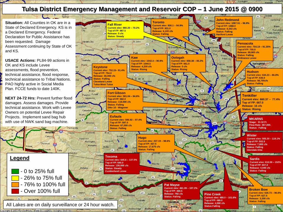
Legend
- 0 to 25% full
- 26% to 75% full
- 76% to 100% full
- Over 100% full
All Lakes are below 50% full unless noted otherwise.
Tulsa District Reservoir Flood Update – 27 May 2015
HugoCurrent elev: 439.7 - 110%
Top of FP: 437.5
Release: 59,112 cfs
Status: Falling
SardisCurrent elev: 610.47 - 150%
Top of FP: 607.0
Release: 4,000 cfs
Status: Falling
TexomaCurrent elev: 643.35 – 120%
Top of FP: 640.0
Release: 83,712 cfs
Status: Rising
EufaulaCurrent elev: 599.49 - 127%
Top of FP: 597.0
Release: 171,000 cfs
Status: Falling
Pat MayseCurrent elev: 460.81 - 103%
Top of FP: 460.5
Release: 786 cfs
Status: Rising Slowly
Broken BowCurrent elev: 627.45 – 99.8%
Top of FP: 627.5
Release: 11,640 cfs
Status: Falling
WisterCurrent elev: 507.72 – 137.7%
Top of FP: 502.5
Release: 20,500 cfs
Status: Falling
KeystoneCurrent elev: 747.34– 70.6%
Top of FP: 754.0
Release: 9,000 cfs
Status: Rising
John RedmondCurrent elev: 1064.3 – 78.2%
Top of FP: 1068.0
Release: 709 cfs
Status: Rising
TorontoCurrent elev: 928.48 – 86.24%
Top of FP: 931.0
Release: 3,627 cfs
Status: Rising
Pine CreekCurrent elev: 480.26 – 100.2%
Top of FP: 480.0
Release: 3,752 cfs
Status: Rising
OologahCurrent elev: 653.9 – 60.6%
Top of FP: 661.0
Release: 0 cfs
Status: Rising
KawCurrent elev: 1036.64 – 67.8%
Top of FP: 1044.5
Release: 40 cfs
Status: Rising
Fort GibsonCurrent elev: 577.27 – 75.6%
Top of FP: 582.0
Release: 0 cfs
Status: Rising
HudsonCurrent elev: 631.75 – 69.6%
Top of FP: 636.0
Release: 25,920 cfs
Status: Rising
PensacolaCurrent elev: 751.7 – 66.7%
Top of FP: 755.0
Release: 29,730 cfs
Status: Rising
BUILDING STRONG®
Legend
- 0 to 25% full
- 26% to 75% full
- 76% to 100% full
- Over 100% full
All Lakes are on daily surveillance or 24 hour watch.
Tulsa District Emergency Management and Reservoir COP – 1 June 2015 @ 0900
HugoCurrent elev: 437.19 – 98.6%
Top of FP: 437.5
Release: 17,675 cfs
Status: Falling
SardisCurrent elev: 610.58 – 152%
Top of FP: 607.0
Release: 4,040 cfs
Status: Falling
TexomaCurrent elev: 645.6 – 137.5%
Top of FP: 640.0
Release: 139,000 cfs
Status: Steady
Cumberland Levee
EufaulaCurrent elev: 596.92 – 97.4%
Top of FP: 597.0
Release: 67,000 cfs
Status: Falling
Pat MayseCurrent elev: 461.09 – 107.2%
Top of FP: 460.5
Release: 792 cfs
Status: Falling
Broken BowCurrent elev: 626.73 – 96.6%
Top of FP: 627.5
Release: 3,200 cfs
Status: Falling
WisterCurrent elev: 505.30 – 119.1%
Top of FP: 502.5
Release: 7,800 cfs
Status: Falling
Glendale Dike
KeystoneCurrent elev: 752.15– 91.4%
Top of FP: 754.0
Release: 30,000 cfs
Status: Falling
Cleveland Levee
Tulsa West Tulsa
John RedmondCurrent elev: 1067.51 – 96.9%
Top of FP: 1068.0
Release: 8,343 cfs
Status: Falling
Hartford Levee
TorontoCurrent elev: 930.1 – 94.9%
Top of FP: 931.0
Release: 6,100 cfs
Status: Falling
Pine CreekCurrent elev: 480.0 – 101.6%
Top of FP: 480.0
Release: 4,590 cfs
Status:Falling
OologahCurrent elev: 658.38 – 85.2%
Top of FP: 661.0
Release: 0 cfs
Status: Rising
KawCurrent elev: 1042.4 – 90.9%
Top of FP: 1044.5
Release: 4,200 cfs
Status: Rising
Fort GibsonCurrent elev: 581.04 – 94.8%
Top of FP: 582.0
Release: 118,000 cfs
Status: Falling
Dike 10 - Wagoner
HudsonCurrent elev: 634.23 – 86.8%
Top of FP: 636.0
Release: 98,700cfs
Status: Falling
PensacolaCurrent elev: 754.19 – 91.35%
Top of FP: 755.0
Release: 89,900 cfs
Status: Falling
Ordinance Levee
MKARNSStage: 33.32 Ft
Flow Rate: 367,000.
Status: Falling
Situation: All Counties in OK are in a
State of Declared Emergency. KS is in
a Declared Emergency. Federal
Declaration for Public Assistance has
been requested. Damage
Assessment continuing by State of OK
and KS.
USACE Actions: PL84-99 actions in
OK and KS include Levee
assessments, flood prevention,
technical assistance, flood response,
technical assistance to Tribal Nations.
PAO highly active in Social Media
Plan. FCCE funds to date 140K.
NEXT 24-72 Hrs: Prevent further flood
damages. Assess damages. Provide
technical assistance. Work with Levee
Owners on potential Levee Repair
Projects. Implement sand bag hub
with use of NWK sand bag machine.
TenkillerCurrent elev: 660.37 – 77.4%
Top of FP: 667.0
Release: 15 cfs
Status: Rising
Fall RiverCurrent elev: 980.20 – 70.2%
Top of FP: 987.5
Release: 5 cfs
Status: Steady

BUILDING STRONG®

BUILDING STRONG®
Fulton Gage
DeKalb Gage
Horatio Gage
Arthur City
Gage

BUILDING STRONG®

BUILDING STRONG®
Tulsa District Overview
Holding as much water as we can to provide flood risk across the region
All projects are operating as designed
Eight flood control projects operating in “Surcharge”► Lake Texoma
► Hugo Lake
► Sardis Lake
► Broken Bow
Hydraulics & Hydrology Branch operating 24/7
Twelve projects are operating in “24/7 Observation” (Park Rangers/Hydropower
Specialists) where required
Engineering & Construction and Dam Safety Production Center engineers deployed
Weeks/Months not days to return projects to “normal operations”
► Pine Creek
► Pat Mayse
► Lake Eufaula
► Wister Lake
27 May 2015 Briefing to Governor Fallin
BUILDING STRONG®
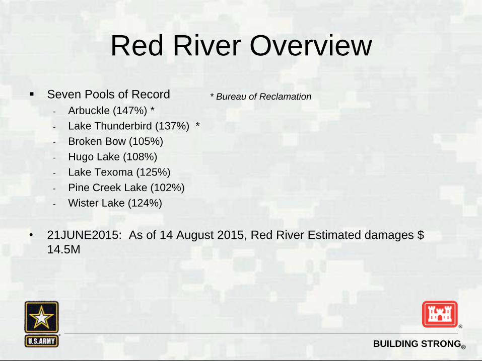
Red River Overview
Seven Pools of Record
- Arbuckle (147%) *
- Lake Thunderbird (137%) *
- Broken Bow (105%)
- Hugo Lake (108%)
- Lake Texoma (125%)
- Pine Creek Lake (102%)
- Wister Lake (124%)
• 21JUNE2015: As of 14 August 2015, Red River Estimated damages $
14.5M
* Bureau of Reclamation

BUILDING STRONG®
Factors & Impacts
Red River
► Flood Risk Management
► Commercial Navigation
► Hydropower
► Recreation
(Fed/State/Private)
► Localized Flooding
► Bridge Closures
► Water Supply @ Broken
Bow (Repaired)
Arkansas River
► Flood Risk Management
► Commercial Navigation
► Hydropower
► Recreation
(Fed/State/Private)
► Localized Flooding
► Inflow from Kansas –
Grand River / Verdigris /
Arkansas
Broken Bow Pumping Station
27 May 2015 Briefing to Governor Fallin

BUILDING STRONG®
Communications
Daily Report
Support to Oklahoma EOC as requested
Tulsa District USACE Official Website
Tulsa District USACE Facebook Page
Responding to Stakeholder Inquiries
Responding to Media Requests
27 May 2015 Briefing to Governor Fallin

BUILDING STRONG®
Communications

BUILDING STRONG®
Contacts
- Congressional Offices
- State Emergency Action Centers
- County Commissioners / City Mayors

BUILDING STRONG®
Flood Response
Federal assistance IAW Public Law 84-99
► Issue Sandbags (76K so far)
► Geospatial Support to Oklahoma EOC
► Technical Assistance as requested (Lake Lawtonka)
Coordination with EM Coordinators established
during annual “Tabletop Exercises”
27 May 2015 Briefing to Governor Fallin
BUILDING STRONG®
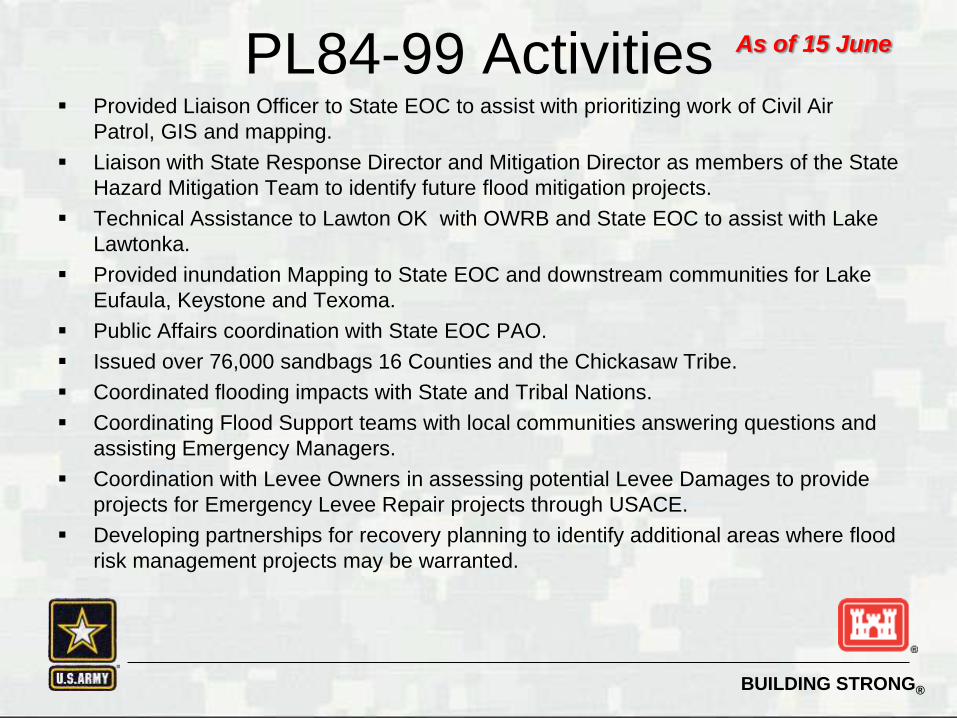
PL84-99 Activities Provided Liaison Officer to State EOC to assist with prioritizing work of Civil Air
Patrol, GIS and mapping.
Liaison with State Response Director and Mitigation Director as members of the State
Hazard Mitigation Team to identify future flood mitigation projects.
Technical Assistance to Lawton OK with OWRB and State EOC to assist with Lake
Lawtonka.
Provided inundation Mapping to State EOC and downstream communities for Lake
Eufaula, Keystone and Texoma.
Public Affairs coordination with State EOC PAO.
Issued over 76,000 sandbags 16 Counties and the Chickasaw Tribe.
Coordinated flooding impacts with State and Tribal Nations.
Coordinating Flood Support teams with local communities answering questions and
assisting Emergency Managers.
Coordination with Levee Owners in assessing potential Levee Damages to provide
projects for Emergency Levee Repair projects through USACE.
Developing partnerships for recovery planning to identify additional areas where flood
risk management projects may be warranted.
As of 15 June

BUILDING STRONG®
31MAY2015: PL 84-99 Sandbag Operations over 75K sandbags
distributed. Sandbags were distributed to locations including
Wagoner, OK and Gainesville, TX.

BUILDING STRONG®

BUILDING STRONG®
Lake Texoma

BUILDING STRONG®
Lake Texoma Auxiliary Spillway 3June2015
Release 124,000 CFS,
Elevation 644.84,131.6%

BUILDING STRONG®
Highway 91, Shawnee Creek, Auxiliary Spillway


•This picture from Lake Texoma was posted on media outlets in France, Ireland, Great Britain, Russia and Japan
•Total reach of Tulsa District Facebook page exceeded 42M views during flood event.

BUILDING STRONG®
With the focus
on the flood
fight, this guy
managed to
sneak thru
security at the
Denison Office
late yesterday
afternoon.
He left without
making a big
stink about it!

BUILDING STRONG®
Cumberland Levee

BUILDING STRONG®
Cumberland Levee
May 2015
Rainfall leads to widespread
flooding throughout SWT
5-28-15
North Levee Windrowed at lowest areas
6-1-15 Levee holds
Texoma Pool and Washita River begin receding
6-17-15
Remnants of Tropical Storm Bill Creates additional
flooding
6-20-2015
Overtopping of North Levee
begins
6-21-2015
Levee Fails
Crest on 5-29-15
Washita River at Dickson
Crest on 06-19-15

BUILDING STRONG®
Transmission Tower
Access Road
Main Breach
Near BreachWindrow Breach
Inundation Area
South Levee Breach
As of 22JUN2015
1
23
4
Initial Overtopping
5
Cumberland Levee

BUILDING STRONG®
Cumberland Levee
Initial Damage & Cleanup
As of 22JUN2015

BUILDING STRONG®
Channel 12 NewsTISHOMINGO, Okla. -- One Oklahoma river is rising to unprecedented levels and others are experiencing major flooding following
a torrent of rain from TD Bill.
The National Weather Service predicts the Washita River near Dickson will crest Thursday night at an all-time high of just over 47
feet.
That's more than 20 feet above flood stage.
The river is projected to rise about 27 feet over a 24-hour period.
The service issued a flood warning for the area saying "catastrophic flood depths are expected to wreak havoc in the Washita River
valley."
More than 10,000 acres of farmland has been flooded and transportation to homes in the area could be cut off for days.

Original Staff Gage
291630MAY2105 Lake Texoma Park Rangers install a new staff gage to measure the height of the Washita River on the North Cumberland Levee

201100June2015, Highway 377 Bridge on Washita River

BUILDING STRONG®
201000June2105 North Cumberland Levee

BUILDING STRONG®
201000June2105 North Cumberland Levee

BUILDING STRONG®
201000June2105 North Cumberland Levee

BUILDING STRONG®
201000June2105 North Cumberland Levee

BUILDING STRONG®
Hugo Lake

BUILDING STRONG®
Hugo Lake 23MAY2015 Release 44,000 CFS,
Elevation 84%

BUILDING STRONG®
Hugo Lake 26MAY2015 Release 59,000 CFS,
Elevation 110%
BUILDING STRONG®
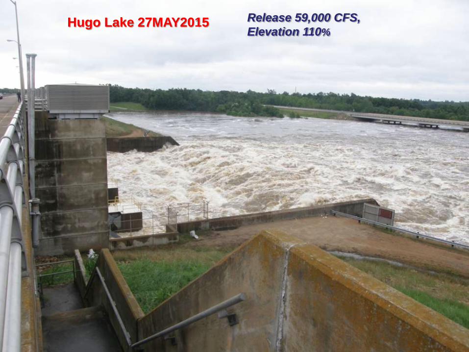
Hugo Lake 27MAY2015 Release 59,000 CFS,
Elevation 110%

BUILDING STRONG®
Hugo Lake 27MAY2015 Release 59,000 CFS,
Elevation 110%

BUILDING STRONG®
Broken Bow
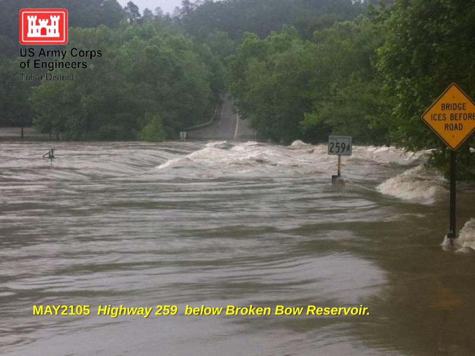
BUILDING STRONG®
MAY2105 Highway 259 below Broken Bow Reservoir.

BUILDING STRONG®
MAY2105 The Tulsa District repairs tainter gate motors at
Broken Bow Reservoir.

261530MAY2105 The Tulsa District repairs tainter gate motors at Broken Bow Reservoir.

261530MAY2105 High releases have permanently changed the trout fishery below the Broken Bow Reservoir.


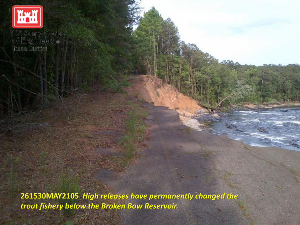
261530MAY2105 High releases have permanently changed the trout fishery below the Broken Bow Reservoir.

261530MAY2105 High releases have permanently changed the trout fishery below the Broken Bow Reservoir.

BUILDING STRONG®
DeKalb Gage

BUILDING STRONG®
DeKalb stream gage on 1June2105

BUILDING STRONG®
Actions around SWT

USACE personnel make daily/hourly checks of the infrastructure at projects in accordance with the project control manual.

Northern Area Operations Project Manager Allen Ryan checks the gate settings at Oologah Lake.

242000MAY2015 Emergency contract actions repair extensive erosion at lake Eufaula, protecting critical infrastructure.

301530MAY2105 The City of Wagoner, OK pumps local runoff over Dike 10 into the Fort Gibson Reservoir. Mayor AJ Jones was on site.
Mayor Jones
Flooding upstream of Dike 10

311330MAY2105 LTC Dan Young and Navigation Systems Operations Manager Bob Steiner inspect the releases at RS Kerr Lock and Dam, where peak releases were 388K cfs.

1June2015 Meeting with City of Miami Mayor at Rotary Park.

26MAY2015 Lake Eufaula releases as much as 172,000 cubic ft per second (twice the rate of water going over Niagara Falls.)

26May2015: WD Mayo Lock & Dam (MKARNS) under water. High flows limited Commercial navigation on the MKARNS from mid-May until mid-June. Navigation is still being impacted due to shoaling from sediment

Questions?

BUILDING STRONG®
Backup Slides

BUILDING STRONG®

BUILDING STRONG®
Fulton Gage
DeKalb Gage
Horatio Gage
Arthur City
Gage

BUILDING STRONG®
Control Points:
Dekalb
44,534 cfs vs.
107,773 cfs
Arthur City
84,446 vs.
71,237 cfs
Muddy Boggy / Unger
15,307 cfs vs.
41,727 cfs
http://www.swt-wc.usace.army.mil/lowerred.html

BUILDING STRONG®

BUILDING STRONG®
This is the limiting factor for the combined
releases from Denison, Hugo & Pat Mayse
projects when not operating in surcharge
operations – DeKalb at 42K cfs

BUILDING STRONG®

BUILDING STRONG®
By the water control manual, we are
regulated to the 25’ stage or 100K cfs unless
there is no downstream flooding, then it is
25’ or whatever the flows support.

BUILDING STRONG®

BUILDING STRONG®

BUILDING STRONG®
Conservation Pools on Red
River
Upper Red
River
Lower Red
River

BUILDING STRONG®
Flood Pools on Red River
Upper Red
River
Lower Red
River

26MAY2015: MKARNS Navigation System. As 0f 14 August, estimated damages of $2.2M

BUILDING STRONG®
Overview
• 700 people
• Arkansas River and Red River Basins in
Oklahoma, Southern Kansas and Northern Texas
• Major Missions of the Corps of Engineers
• War Fighting
• Navigation
• Flood Control (Flood Risk Management)
• Military Construction
• Regulatory/Environmental
• Homeland Security
Mike Abate in Iraq

BUILDING STRONG®
• Engineering
Control Tower
Vance AFB
Air Defense Artillery School
Fort Sill
Medical Facility
Tinker AFB
• Environmental Management
• Construction • Installation Support
Vance AFB
Tinker AFB
Altus AFB
Fort Sill
McAlester
Sheppard AFB
KC 46A Program
Altus AFB
ENJPT Training Facility
Sheppard AFB
Reserve Center
McAlester Army
Ammunition Plant
Military Mission
Pantex

BUILDING STRONG®
Military Update
Fort Sill
- Reception Complex
- Terminal High Altitude Area Defense
- Fitness Center
- Chapel
Altus AFB
- KC-46A Pegasus Construction Project
Vance AFB
- Control Tower
- Repair Outside Runway and Taxiway
Tinker AFB
- Land Acquisition for KC46A Construction
McAlester AAP
- Employee Changing /Decontamination Facility
Sheppard AFB
- Medical/Dental Replacement Clinic

BUILDING STRONG®
Grand Lake
Webbers Falls Turbine
Tenkiller Lake
Inland Navigation
(MKARNS)
• 5 locks & dams
• 3 major ports
Hydroelectric Power
• 8 power plants
produce 585,000 kw
capacity
• Generates power to 8
million customers
Water Supply
Environmental Stewardship
Recreation
• 267 recreation
areas at 33 projects
• 23 million visitors
in 2014
Flood Risk Management
• 38 Corps dams + 12 others
• 15,950,000 acre feet of
flood storage
• Arkansas River Basin:
$11,144B in cumulative
flood damage reductions
• Red River Basin:
$1,936B in cumulative
flood damage reductions
• 60% of Corps water supply contracts
• 18 lakes, 131 water supply customers
• 2.2 million people served
• Enhances municipal, industrial,
irrigation usage
• Protects endangered species
• Improves degraded streams
Water Quality
Red River Chloride, Area VI
• Tenkiller Low Flow Pipe
• Supersaturated Dissolved
Oxygen System (SDOX)
Civil Works Mission

Current Situation
Concerns Way Ahead
Lower Bois d'Arc Creek Reservoir
North Texas Municipal Water District (NTMWD) proposes a
16,400 surface acre water supply lake in Fannin County
Near-term water supply for the growing urban population
north and east of Dallas-Fort Worth metroplex
Clean Water Act Section 404 permit required from the
USACE for construction of the dam
Due to scope and magnitude of potential impacts, an
Environmental Impact Statement (EIS) is being required
Highly cooperative and responsive applicant
Public Notice and Scoping Meetings generated numerous
comments from the affected public and Federal and State
agencies in opposition to the project
Identified concerns are evaluation of alternatives, demand
projections vs conservation/reuse, socio-economic impacts,
terrestrial and aquatic wildlife and resources impacts,
historic/cultural properties, and aquatic resource mitigation
Draft EIS released February 2015 generated similar comments
EPA rated the Draft EIS as a “3 – Inadequate” in June 2015
Evaluate comments, re-examine alternatives and
potential impacts, and revise EIS, in accordance with
procedures in Nat’l Environmental Policy Act (NEPA)
Complete functional assessment of wooded wetlands
Refine the Aquatic Resources Mitigation Plan
- NTMWD has proposed aquatic ecological restoration
as mitigation on portions of 15,000 ac ranch at Bois d’Arc
Creek confluence with Red River
Culminate with publication of a Final EIS
.

BUILDING STRONG®
Pine Creek Dam Safety
Current Situation
• Dam Safety Modification Study completed and
approved by Headquarters USACE and concurred
by ASA (CW) Darcy for construction in FY15
• Cutoff Wall is near completion and should be
complete by 1 September.
•Steel pipe liner has been delayed until summer
2016 to take advantage of the low flows during
summer months.
Concerns
• Void around the conduit
• Loss of material through the conduit joints
• Loss of material at the downstream exit face
• Hydraulic fracture within the embankment
Way Ahead
• Construct downstream filter and chimney filter.
• Construct the steel pipe liner Summer 2016.
• Interim Risk Assessment will begin in Sep 2016
• Reassess dam with modifications in
place (June 2017)
PICTURE

BUILDING STRONG®
Waurika DredgingCurrent Situation
A water supply intake channel was constructed
during initial construction of the water supply intake
Over time, the water supply intake channel has
Become filled with sediment necessitating the need
for maintenance dredging of the intake channel
Dredging the intake channel would significantly increase
the dependable water yield to the conveyance system
and
improve water quality
Way AheadStrategic Alliances and Sponsor: Waurika Lake
Master Conservancy District
Actions/Funding Requirements:
FY2015: $50,000
The Waurika Lake Master Conservancy District (WLMCD)
requested Section 408 authorization to restore Lake Waurika’s
dependable water volume yield of the conservation pool and
improve raw water quality in April 2015
After District agency technical review, the WLMCD’s request was
approved pursuant to Section 14 of the Rivers and Harbors Act
of 1899, 33 USC 408 on 14 July 2015. This authorization was
imperative for significantly increasing the dependable water yield
to the conveyance system and improving the water quality for
community members serviced by the WLMCD

BUILDING STRONG®
Daily Briefings
Media Interviews