Embed Size (px)
Citation preview

COGCC Interim Policy for APDs
TutorialDecember 2008

Purpose of Interim Policy and Interim Policy Period
The Interim Policy was requested by the Commission to gather data on the number of permits filed in areas identified as sensitive or that will be subject to consultation under the revised rules. The policy will require operators to identify these areas on all Application for Permit to Drill (APD) filed in the interim period between January 5 and May 1, 2009 on federal lands and between January 5 and April 1, 2009 for all other lands. It will also provide an opportunity for CDPHE and CDOW to provide input on APDs filed in those areas and for operators to respond to such input.

Purpose of Interim Policy and Interim Policy Period
• Allow state agencies to refine their business processes so that when the amended rules become effective agencies can meet the new timeframes and requirements.
• Allow the COGCC to gather information on APDs in environmentally sensitive areas and create mechanisms for obtaining CDPHE & CDOW input on APDs in those areas before the new rules become effective.
• Allow operators to see the types of conditions of approval that the agencies envision might be required to mitigate impacts to water and wildlife resources from proposed operations.

Areas to be Identified in the Interim Policy Period
Drinking water protection areas; Restricted surface occupancy areas; Sensitive wildlife habitat areas; and Riparian areas,
areas within 300 feet of streams and lakes west of Interstate 25

Available Tools to Perform the Interim Policy Review
Review location with:Oil and Gas Activity Notification ToolTemporary Point Mapping ToolCOGCC GIS Online Map
Interim Policy for APDs form
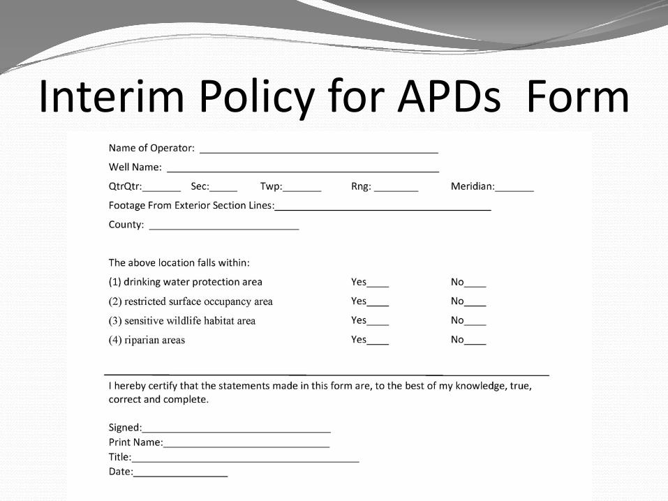
Interim Policy for APDs Form

Interim Process ‐OperatorOperator Identifies Drilling Location on APDOperator enters QQ Sec Township Range in the Oil and Gas Activity Notification ToolIf no areas are returned, complete the Interim Policy for APDs FormIf the quarter‐quarter contains any areas identified as YES (Y), then you will need to use the maps to identify the specific type of area(s) where the location falls If the Latitude and Longitude are known then use the Temporary Point Mapping ToolOtherwise use the COGCC GIS Online to view details and determine which areas apply to the proposed locationYou must mark “Yes “ or “No” for each area on the Interim Policy for APDs FormSensitive Wildlife HabitatRestricted Surface Occupancy AreaDrinking Water Protection Area BufferPerennial Stream or Lake BufferAttach Interim Policy for APDs Form to APD and file with COGCC

Interim Process‐COGCC
COGCC reviews and forwards APD form and Plat if in an area identified on the Interim Policy form to the applicable agency (CDOW and/or CDPHE) for review
CDOW and/or CDPHE will review APDs and recommend conditions of approval in a timely manner
COGCC will review COA recommendations and will forward the operator the recommended COAs for a response
COGCC determines whether to include COAs and issues APD

Access to New Tools

Oil and Gas Activity Notification Tool
Click Help then choose: Oil and Gas Activity Notification Tool

New Map LayersRule 317B Buffer ZonesDrinking Water Protection Areas
1200‐Series Wildlife AreasRSO Areas
Restricted Surface Occupancy AreasSWH Areas
Sensitive Wildlife Habitats
300 –Foot Stream BuffersPerennial Streams and Lakes (West of I‐25)

Go to http://cogcc.state.co.us/ and click on Maps
You must have the Viewer Pluginto View Maps!
Click Here for Viewer Plugin Instructions

Install Viewer Plugin if it has not already been installed

If Proposed Location Latitude and Longitude Not Known:Launch GIS Online Map to Area of Interest
Click View Map

Zoom to Township of Interest
Right Click on MapChoose Zoom to TownshipEnter Township in Location Field

View Rule 317B Surface Water Buffers
Click On Rule 317B Buffer Zones Layer

Zoom in to a Section to See DetailsTo Zoom:Click on Magnifying GlassBring Curser Back to MapDrag Zoom Box around Section

View 1200‐Series Restricted Surface Occupancy (RSO) Areas
Click on RSO Areas Layer

View 1200‐Series Sensitive Wildlife Habitat (SWH) Areas
Click on the SWH Areas Layer

View 300‐Foot Perennial Stream and Lake Buffers
300-Foot Stream Buffers
Click on 300-Foot Stream Buffers

For Detailed Species‐Specific Wildlife Maps
Click on Wildlife MapFrom Maps Page

Toggle Through Species Lists
Click each species layer onNote: It is best to turn each species layer off before turning a new one on to avoid overlapping polygons covering up the species of interest

If Proposed Location Latitude and Longitude Known: Use the Temporary Point Mapping Tool (found in the Help Section). Input the latitude and longitude and the select “Map It” button.

Blue X marks your spot. This view shows 317B buffers, SWH and RSO Wildlife areas and 300’ stream buffers.

Download Wildlife GIS Shapefiles
Click GIS Downloads
Save File to Your Computer

Please watch the website for any additional information and guidance documents as we prepare for the
implementation of the amended rules.
http://cogcc.state.co.us