Embed Size (px)
Citation preview

Coastal Vulnerability Assessment and
Getting to Resilience
Trenton, NJ
Coastal Vulnerability Assessment and Getting to Resilience- Trenton, NJ
2 | P a g e
Funding for this project is provided by the U.S. Department of the Interior and administered by
the National Fish and Wildlife Foundation as part of the Hurricane Sandy Coastal Resiliency
Competitive Grant Program.
Prepared by the Environmental Analysis and Communications Group, Rutgers University, for the
City of Trenton.
The views and conclusions contained in this document are those of the authors and should not
be interpreted as representing the opinions or policies of the U.S. government or the National
Fish and Wildlife Foundation and its funding sources. Mention of trade names or commercial
products does not constitute their endorsement by the U.S. Government, or the National Fish
and Wildlife Foundation or its funding sources.

Coastal Vulnerability Assessment and Getting to Resilience- Trenton, NJ
3 | P a g e
Contents
I. Project Introduction………………………………………………………………….................................4
Figure 1: Range of Sea Level Rise Estimates (Miller et.al)………………………………………….4
Figure 2: Tide Gage Data (Miller et.al)………………………………………………………………………5
II. Community Profile……………………………………………………………………………………………………6
Image 1: The NJ State House along the Delaware River (PBS)…………………………………..6
Image 2: Flooding in Flooding (International Business Times)…………………………………..7
III. Municipal Coastal Vulnerability Assessment Methodology ………………………….………….7
Graphic 1: Flood Hazard Map….....................................................................................8
IV. Findings and Recommendations……………………………………………....................................9
Graphic 2: Assumpink Greenway…………………………………………………………………………….10
Recommendations from the Mercer County Hazard Mitigation Plan that are in line
with the CVA.…………………………………………………………...…………………………………………….10
National Flood Insurance Program (NFIP) and the Community Rating System
(CRS)……………………………………………………………………………............................................11
Getting to Resilience GTR)………………………………………………………………………………………11
Appendices………………………………………………………………………….....................................13
Map 1: City of Trenton – Mercer County NJ……………………………………………………………14
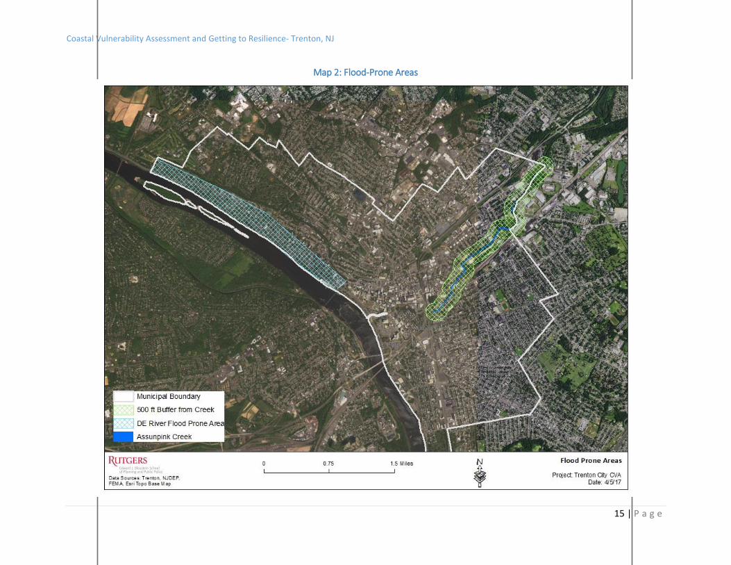
Map 2: Flood Prone Areas…………………………………………………………..............................15
Map 3: Land Use in the Flood Prone Areas……………………………………………………………..16
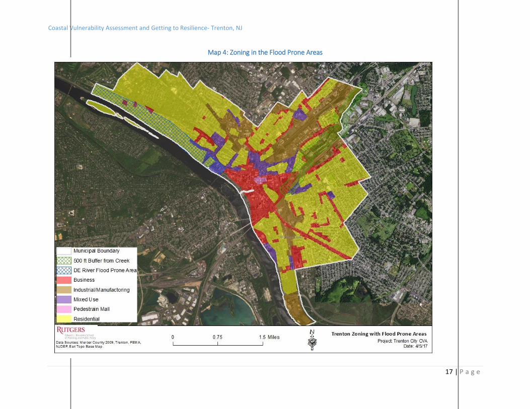
Map 4: Map 4: Zoning in the Flood Prone Areas……………………………………………………..17
Map 5: Severe Repetitive Loss Area ………..................................................................18
Map 6: Recreation and Open Space Inventory (ROSI) Properties
and Flood Prone Areas……………………………………………………………………………………………19
Getting to Resilience (GTR)…………………………………………………………………………………….20

Coastal Vulnerability Assessment and Getting to Resilience- Trenton, NJ
4 | P a g e
I. Project Introduction
As stated in the 2011 NJDEP document New Jersey’s Coastal Vulnerability Assessment and
Mapping Protocol, vulnerability is defined as “the degree of exposure and inability of a human
or natural system to cope with the effects of a natural hazard, including changing variability and
extremes in weather and climate.”
This report aims to assess vulnerabilities to enable communities in the planning for future
exposures and develop strategies for mitigating long-term risk, making communities more
resilient. To do so, this report assesses community vulnerability to sea level rise projected for
the year 2050 along with a category 1 hurricane storm surge.
Figure 1: Range of Sea Level Rise Estimates (Miller et.al)
Figure 1 illustrates the sea level rise range of
estimates for 2030, 2050, and 2100.
This publication calls for a central projection
of 1.5 feet of sea level rise along the shore in
2050 and is the projection used in this
report.

Coastal Vulnerability Assessment and Getting to Resilience- Trenton, NJ
5 | P a g e
Figure 2: Tide Gage Data (Miller et.al)
Figure 2 illustrates
tide gage data
taken along the
Eastern seaboard
from 1900 to past
the year 2000.
Miller et.al.
attribute a higher
rate of rise in the
coastal plains to
coastal subsidence
and groundwater
withdrawal and
compaction.
Category 1 storm surge data was mapped using the Sea, Lake, and Overland Surge from
Hurricanes (SLOSH) data developed by the National Weather Service/NOAA to estimate storm
surge heights resulting from historical, hypothetical, or predicted hurricanes, taking into
account the atmospheric pressure, size, forward speed, and track data of storms.
According to the National Hurricane Center, Category 1 storm characteristics include:
• Sustained winds of 74-95 mph
• Well-constructed frame homes could have damage to roof, shingles, vinyl siding and gutters.
• Large branches of trees will snap and shallow rooted trees may be toppled.
• Extensive damage to power lines and poles likely will result in power outages that could last a
few to several days.

Coastal Vulnerability Assessment and Getting to Resilience- Trenton, NJ
6 | P a g e
II. Community Profile Trenton is the capital of New Jersey and the County Seat of Mercer County. The City is part of
the New York metropolitan area and borders the Philadelphia metropolitan area. The City
consists of the Downtown, then the North, South, East, and West wards, with the government
and central business being located in the Downtown.
According to the 2015 US Census ACS 5-Year Population Estimate, the population of Trenton
was 84,632, making it the 10th most populated municipality in the State. The City is comprised
of 7.7 square miles of land area with over 11,000 people per square mile. The median age of
Trenton residents is 33.8 years old, the median household income is $34,257, and the median
home value of an owner occupied unit is $107, 200.
Trenton’s entire western border lies along the Delaware River (Refer to Map #1) making it
vulnerable to riverine flooding.
Image 1: The NJ State House along the Delaware River (PBS)

Coastal Vulnerability Assessment and Getting to Resilience- Trenton, NJ
7 | P a g e
Image 2: Flooding in Flooding (International Business Times)
III. Municipal Coastal Vulnerability Assessment Methodology The CVA/GTR meeting was held on April 12th at City Hall. City personnel in attendance to assist
in identifying the flood prone areas, finalize mapping, and complete the GTR assessment
included:
Qureeb Bashir, Coordinator, Office of Emergency Management
JR Capasso, Brownfields Coordinator
Merkel Cherry, Director, Public Works
Jeffrey Wilkerson, City Planner
The process for completing the CVA was done in three steps:
1. Identify Community Assets
2. Establish Vulnerabilities and Consequences
3. Recommendations
CVA Step 1: Identifying Community Assets Typically when a CVA is completed, community assets from four general areas are indexed in a matrix and then used to support the development of asset mapping, identification of depth inundations, community-led findings, and eventual recommendations. These four asset areas include:
Community Resources: Schools, shelters, storm-related retail, major employers,
churches, food banks, etc.

Coastal Vulnerability Assessment and Getting to Resilience- Trenton, NJ
8 | P a g e
Critical Infrastructure and Facilities: Government operations, utilities, evacuation
routes, emergency response
Natural and Ecosystem Resources: Beaches, bayfronts, wetlands/critical habitat, parks
Vulnerable Sites and Populations: Identifiable clusters of senior citizens, low income
populations, limited English proficient populations, mobile home parks,
contaminated/otherwise hazardous materials/sites
While Trenton does not experience typical coastal storm surge and will not see the impacts of
sea level rise that coastal communities located along the ocean will likely experience, the City
does have flood-prone areas that are likely to worsen as sea level rise in the future.
Prior to the CVA meeting, staff at Rutgers University used information found in the Mercer
County Hazard Mitigation Plan and FEMA Severe Repetitive Loss property data to map two
flood-prone areas in the City. This data was then used to create draft mapping in preparation
for the CVA meeting with City officials.
The two flood prone focus areas chosen were the shorelines of the Delaware River and the
Assumpink Creek. (Refer to Map #2)
The first flood prone area is an area located along the Delaware River coastline at the North
West section of the City. The second flood prone area chosen was a 500 ft. buffer around the
Assumpink Creek, which is located across the center of the City to the border with Hamilton
Township.
Graphic 1: Flood Hazard Map (Source: Mercer County HMP)
The graphic above was taken from the 2016 Mercer County Hazard Mitigation Plan Update and
shows much of the area surrounding Assumpink Creek and along the Delaware River mapped
as the 1% Chance Annual Hazard. A 1% annual chance flood (or base flood) has a 1% annual
chance of being equaled or exceeded in any given year.

Coastal Vulnerability Assessment and Getting to Resilience- Trenton, NJ
9 | P a g e
IV. Findings and Recommendations
Consider Non-Contiguous Clustering to gradually move residents out of the flood zone.
The majority of the Delaware coastline in Trenton consists of residential development, while
the Assumpink Creek buffer is a mix of commercial, industrial, recreational, and residential,
with the majority being industrial. (Refer to Maps #3 and #4)
One way to address a large amount of existing residential in a City is to explore opportunities
for noncontiguous clustering. With this technique, one parcel is preserved while its
development rights are transferred to a different, noncontiguous parcel which is developed at a
higher density than otherwise permitted. Noncontiguous clustering could be used by the City
as a gradual way to relocate residents out of flood prone areas.
The City can reference a template ordinance and more in depth information on noncontiguous
clustering available from Sustainable Jersey
o Resource: Template Ordinance
Routinely collect, maintain, and map Severe Repetitive Loss property data for community
outreach/education and to develop a targeted plan on addressing flooding in the area
Continue to Utilize the Blue and Green Acres Programs for properties in the two flood prone
areas
Explore Severe Repetitive Loss grant funding for properties in the area
Severe Repetitive Loss properties consists of any NFIP-insured residential property that has met
at least 1 of the following paid flood loss criteria since 1978, regardless of ownership:
• 4 or more separate claim payments of more than $5,000 each (including building and
contents payments); or
• 2 or more separate claim payments (building payments only) where the total of the
payments exceeds the current value of the property
According to FEMA, as of 2014, there are 10 Severe Repetitive Loss properties in the City of
Trenton and all are located along the Delaware River within an area consisting of 24 Census
Blocks. (Refer to Map #5)
ROSI data from the City (2010) and the NJDEP (2014) was mapped to illustrate where land has
been preserved in the City to date. According to NJDEP, as of June 2014, 254 properties have
already been preserved through the State’s Green Acres Program. (Refer to Map #6)
While there are many areas of preserved land along the Assumpink Creek, fewer properties
have been acquired along the northeast coastline of the Delaware River where the Severe
Coastal Vulnerability Assessment and Getting to Resilience- Trenton, NJ
10 | P a g e
Repetitive Loss properties are located. A local effort could be made to apply for additional
Green and Blue Acres funding to acquire more land along the Delaware, with an emphasis on
the Severe Repetitive Loss properties.
o Resource: NJ Severe Repetitive Loss Strategy
o Resource: Green and Blue Acres Program
Graphic 2: The Assumpink Greenway (Source: Trenton, NJ)
In an effort to
mitigate flood risk in a
contiguous area,
along with focusing
Green and Blue Acre
property acquisition
along the Delaware
River, this funding
should also focus on
areas that experience
flooding and are seen
as “missing links”
along the Greenway.
(Refer to Graphic #2)
Recommendations from the Mercer County Hazard Mitigation Plan that
are in line with the CVA The 2016 Update to the Mercer County Hazard Mitigation Plan recommends the following
hazard mitigation initiatives that are in line with the findings of the CVA:
Coastal Vulnerability Assessment and Getting to Resilience- Trenton, NJ
11 | P a g e
Continue to work with acquired properties located in the flood prone areas of the City
(Taylor Street and Amtico Square)
Taylor Street and Amtico Square are located along the Assumpink Creek. They are formerly
flood prone, industrial areas. While there has been open space acquisitions in this area, there
are gaps in preserved areas.
National Flood Insurance Program (NFIP) and the Community Ratings
System (CRS) Trenton City is an NFIP participating municipality with 359 policies in force. Of these 359, 121
are Repetitive Loss Properties, including the 10 Severe Repetitive Loss Properties referenced
earlier in this report. Currently, Trenton does not participate in the CRS Program; doing so
would result in insurance premium discounts for the 359 policy holders.
The full output of the Getting to Resilience Assessment is located in the Appendices and offers
directs links between local actions and possible CRS points.
Getting to Resilience (GTR) GTR is an online self-assessment process tool to assist communities to reduce vulnerability and
increase preparedness by linking planning, mitigation, and adaptation. Through this
assessment, municipalities can see how preparedness can be worth valuable points through
FEMA’s Community Rating System and Sustainable Jersey Certifications.
The GTR assessment was completed on April 12th at City Hall.
Below are key recommendation pulled out from the assessment output. The final output in its
entirety is included in the Appendices.
Section I. Risk and Vulnerability Assessments
Map Repetitive Loss/Severe Repetitive Loss Properties / Draft a Repetitive Loss Area Analysis
and use this information to inform zoning strategies
[Repetitive Loss Area Analysis (RLAA): Up to 140 CRS points for a detailed mitigation
plan for a repetitive loss area.]
o Resource: Repetitive Loss Area Analysis Guidance
Map flood risk in relation to vulnerable populations (elderly, children, poor, disabled,
linguistically isolated)
o Resource: Social Vulnerability on NJ Floodmapper
Develop a build out analysis based on current zoning / compare to the extent of flooding
Coastal Vulnerability Assessment and Getting to Resilience- Trenton, NJ
12 | P a g e
Section II. Public Engagement
Install publicly visible high water mark signs
[Historic Flood Information (MI6): 20 CRS points for providing information about
past flooding at or near the site in question]
o Resource: FEMA High Water Mark Initiative
o Resource: Monmouth County High Water Mark Initiative
Section IV. Disaster Preparedness and Recovery
Utilize risk and vulnerability mapping to determine areas unfit for future development
Risk and vulnerability mapping could be used to assess expansion of open space acquisitions.
o Resource: NJ Floodmapper
Section V. Hazard Mitigation Implementation
Utilize Transfer of Development Rights (TDR)
TDR can be used to direct development away from environmentally sensitive or vulnerable
areas and into areas better suited for development, particularly higher densities.
o Resource: NJ TDR Program

Appendices

Coastal Vulnerability Assessment and Getting to Resilience- Trenton, NJ
14 | P a g e
Map 1: City of Trenton – Mercer County NJ
Coastal Vulnerability Assessment and Getting to Resilience- Trenton, NJ
15 | P a g e
Map 2: Flood-Prone Areas

Coastal Vulnerability Assessment and Getting to Resilience- Trenton, NJ
16 | P a g e
Map 3: Land Use in the Flood Prone Areas
Coastal Vulnerability Assessment and Getting to Resilience- Trenton, NJ
17 | P a g e
Map 4: Zoning in the Flood Prone Areas

Coastal Vulnerability Assessment and Getting to Resilience- Trenton, NJ
18 | P a g e
Map 5: Severe Repetitive Loss Area

Coastal Vulnerability Assessment and Getting to Resilience- Trenton, NJ
19 | P a g e
Map 6: Recreation and Open Space Inventory (ROSI) Properties and Flood Prone Areas
Full Output: Getting to Resilience Assessment
I. Risk & Vulnerability Assessments a. 1.1
Has your community discussed and/or identified previous coastal hazards
and disasters?
You answered:
Yes
CRS Suggestions
Section 410: Floodplain Mapping: To improve the quality of the mapping that is
used to identify and regulate floodplain development.
New Study (NS): Up to 290 points for new flood studies that produce
base flood elevations or floodways.
Floodplain mapping of special flood-related hazards (MAPSH): Up to
50 points if the community maps and regulates areas of special flood
related hazards.
CRS points : 340
Sustainable Jersey Suggestions
Climate Adaptation: Flooding Risk (20 points)
This Sustainable Jersey action, under the category of “Climate Adaptation,” is
designed to help communities identify: 1) your community’s vulnerability to
flooding impacts (both coastal and inland) and 2) ways to improve your
community’s overall resiliency. This action focuses on the various causes of
flooding that could impact a community, either now or in the future, including
increased precipitation, increased frequency of heavy precipitation events, sea
level rise and storm surge. Completion of this action item will count for a total of
20 points and will serve as a prerequisite for future companion Sustainable Jersey
actions related to flooding and resiliency.
SJ points : 20
Hazard Mitigation Suggestions
Coastal Vulnerability Assessment and Getting to Resilience- Trenton, NJ
21 | P a g e
Communities that are part of a countywide Multi-Jurisdictional Hazard
Mitigation Plan update should consider these elements as specified by the FEMA
Local Mitigation Plan Review Guide.
Element B.2.a. The plan must include the history of previous hazard events
for each of the identified hazards.
Element B.2.c. Plan updates must include hazard events that have occurred
since the last plan was developed.
c. 1.1.1
Has your community documented previous coastal hazards and
disasters through historical information, existing plans and reports,
scientific knowledge, and/or local knowledge?
You answered:
Yes
CRS Suggestions
Section 410: Floodplain Mapping: To improve the quality of the
mapping that is used to identify and regulate floodplain
development.
New Study (NS): Up to 290 points for new flood studies that
produce base flood elevations or
floodways.
Floodplain mapping of special flood-related hazards
(MAPSH): Up to 50 points if the community maps and regulates
areas of special flood related hazards.
CRS points : 340
Sustainable Jersey Suggestions
Climate Adaptation: Flooding Risk (20 points)
This Sustainable Jersey action, under the category of “Climate
Adaptation,” is designed to help communities identify: 1) your
community’s vulnerability to flooding impacts (both coastal and inland)
and 2) ways to improve your community’s overall resiliency. This action
focuses on the various causes of flooding that could impact a community,
either now or in the future, including increased precipitation, increased
frequency of heavy precipitation events, sea level rise and storm surge.
Coastal Vulnerability Assessment and Getting to Resilience- Trenton, NJ
22 | P a g e
Completion of this action item will count for a total of 20 points and will
serve as a prerequisite for future companion Sustainable Jersey actions
related to flooding and resiliency.
SJ points : 20
Hazard Mitigation Suggestions
Communities that are part of a countywide Multi-Jurisdictional Hazard
Mitigation Plan update should consider these elements as specified by
the FEMA Local Mitigation Plan Review Guide.
Element B.2.a. The plan must include the history of previous hazard
events for each of the identified hazards.
Element B.2.c. Plan updates must include hazard events that have
occurred since the last plan was developed.
b. 1.2
Has your community defined hazard probability, frequency, magnitude, and
duration?
You answered:
Yes hmp notes prob of occ., impacts and ranking
CRS Suggestions
Section 410: Floodplain Mapping: To improve the quality of the mapping that is
used to identify and regulate floodplain development.
New Study (NS): Up to 290 points for new flood studies that produce
base flood elevations or floodways.
Floodplain mapping of special flood-related hazards (MAPSH): Up to
50 points if the community maps and regulates areas of special flood
related hazards.
Sustainable Jersey Suggestions
Climate Adaptation: Flooding Risk (20 points)
This Sustainable Jersey action, under the category of “Climate Adaptation,” is
designed to help communities identify: 1) your community’s vulnerability to
flooding impacts (both coastal and inland) and 2) ways to improve your
community’s overall resiliency. This action focuses on the various causes of

Coastal Vulnerability Assessment and Getting to Resilience- Trenton, NJ
23 | P a g e
flooding that could impact a community, either now or in the future, including
increased precipitation, increased frequency of heavy precipitation events, sea
level rise and storm surge. Completion of this action item will count for a total of
20 points and will serve as a prerequisite for future companion Sustainable Jersey
actions related to flooding and resiliency.
SJ points : 20
Hazard Mitigation Suggestions
Communities that are part of a countywide Multi-Jurisdictional Hazard
Mitigation Plan update should consider this element as specified by the FEMA
Local Mitigation Plan Review Guide.
Element B.1.c. The description, or profile, must include information on
location, extent, previous occurrences, and future probability for each hazard.
Extent means the strength or magnitude of the hazard.
Element B.2.b. The plan must include the probability of future events for
each identified hazard. Probability means the likelihood of the hazard occurring
and may be defined in terms of general descriptors (for example, unlikely, likely,
highly likely), historical frequencies, statistical probabilities (for example: 1%
chance of occurrence in any given year), and/or hazard probability maps. If
general descriptors are used, then they must be defined in the plan. For example,
“highly likely” could be defined as equals near 100% chance of occurrence next
year or happens every year.
c. 1.3
Has your community identified coastal erosion and/or shoreline change as a
hazard? How?
You answered:
No not in HMP for county
Things to Consider
Communities that are members of the CRS should look into achieving this task in
order to earn CRS credit points and gain a better community rating.
Section 410: Floodplain Mapping: To improve the quality of the mapping that is
used to identify and regulate floodplain development.

Coastal Vulnerability Assessment and Getting to Resilience- Trenton, NJ
24 | P a g e
Floodplain mapping of special flood-related hazards (MAPSH): Up to
50 points if the community maps and regulates areas of special flood
related hazards.
Section 420: Open Space Preservation: To prevent flood damage by keeping
flood prone lands free of development, and protect and enhance the natural
functions of flood plains.
Special flood-related hazards open space (SHOS): Up to 50 points if
the OSP credited parcels are subject to one of the special flood-related
hazards or if areas of special flood related hazard are covered by low
density zoning regulations.
Section 430: Higher Regulatory Standards: To credit regulations to protect
existing and future development and natural floodplain functions that exceed the
minimum criteria of the National Flood Insurance Program.
Special Flood-related Hazard Regulations (SHR): Up to 370 points for
higher regulatory standards in areas subject to coastal erosion.
Section 440: Flood Data Maintenance: To make community floodplain data
more accessible, current, useful, and/or accurate so that the information
contributes to the improvement of local regulations, insurance rating, planning,
disclosure, and property appraisals.
Erosion Data Maintenance (EDM): up to 20 points for maintaining
coastal erosion data.
Section 540: Drainage System Maitenance: To ensure that the community
keeps its channels and storage basins clear of debris so that their flood drainage
and storage capacity are maintained.
Coastal Erosion Protection Maitenance (EPM): Up to 100 points for
maintaining erosion protection programs in communities with coastal
erosion prone areas.
Communities that are part of a countywide Multi-Jurisdictional Hazard
Mitigation Plan update should consider this element as specified by the FEMA
Local Mitigation Plan Review Guide.
Element B.1.a. The plan must include a description of the natural hazards
that can affect the jurisdiction(s) in the planning area.
Communities working towards Sustainable Jersey Certification should consider
the following actions.
Coastal Vulnerability Assessment and Getting to Resilience- Trenton, NJ
25 | P a g e
Climate Adaptation: Flooding Risk (20 points)
This Sustainable Jersey action, under the category of “Climate Adaptation,” is
designed to help communities identify: 1) your community’s vulnerability to
flooding impacts (both coastal and inland) and 2) ways to improve your
community’s overall resiliency. This action focuses on the various causes of
flooding that could impact a community, either now or in the future, including
increased precipitation, increased frequency of heavy precipitation events, sea
level rise and storm surge. Completion of this action item will count for a total of
20 points and will serve as a prerequisite for future companion Sustainable Jersey
actions related to flooding and resiliency.
d. 1.4
Does your community identify sea level rise as a hazard? How?
You answered:
No not in HMP for county
Things to Consider
Communities that are members of the CRS should look into achieving this task in
order to earn CRS credit points and gain a better community rating.
Section 340: Hazard Disclosure: To disclose a property's potential flood hazard
to potential buyers before the lender notifies them of the need for flood
insurance.
Disclosure of Other Hazards (DOH): Up to 8 points if the notification to
prospective buyers includes disclosure of other flood related hazards, such
as erosion, subsidence, or wetlands.
Section 410: Floodplain Mapping: To improve the quality of the mapping that is
used to identify and regulate floodplain development.
Higher Study Standards (HSS): Up to 160 points if the new study was
done to one or more standards higher than the FEMA mapping criteria.
Communities that are part of a countywide Multi-Jurisdictional Hazard
Mitigation Plan update should consider this element as specified by the FEMA
Local Mitigation Plan Review Guide.
Element B.1.a. The plan must include a description of the natural hazards
that can affect the jurisdiction(s) in the planning area.

Coastal Vulnerability Assessment and Getting to Resilience- Trenton, NJ
26 | P a g e
Communities working towards Sustainable Jersey Certification should consider
the following actions.
Climate Adaptation: Flooding Risk (20 points)
This Sustainable Jersey action, under the category of “Climate Adaptation,” is
designed to help communities identify: 1) your community’s vulnerability to
flooding impacts (both coastal and inland) and 2) ways to improve your
community’s overall resiliency. This action focuses on the various causes of
flooding that could impact a community, either now or in the future, including
increased precipitation, increased frequency of heavy precipitation events, sea
level rise and storm surge. Completion of this action item will count for a total of
20 points and will serve as a prerequisite for future companion Sustainable Jersey
actions related to flooding and resiliency.
e. 1.5
Are historic rates of sea level defined?
You answered:
No
Things to Consider
Communities that are members of the CRS should look into achieving this task in
order to earn CRS credit points and gain a better community rating.
Section 340: Hazard Disclosure: To disclose a property's potential flood hazard
to potential buyers before the lender notifies them of the need for flood
insurance.
Disclosure of Other Hazards (DOH): Up to 8 points if the notification to
prospective buyers includes disclosure of other flood related hazards, such
as erosion, subsidence, or wetlands.
Section 410: Floodplain Mapping: To improve the quality of the mapping that is
used to identify and regulate floodplain development.
Higher Study Standards (HSS): Up to 160 points if the new study was
done to one or more standards higher than the FEMA mapping criteria.
Communities that are part of a countywide Multi-Jurisdictional Hazard
Mitigation Plan update should consider this element as specified by the FEMA
Local Mitigation Plan Review Guide.
Coastal Vulnerability Assessment and Getting to Resilience- Trenton, NJ
27 | P a g e
Element B.1.a. The plan must include a description of the natural hazards
that can affect the jurisdiction(s) in the planning area.
b. 1.5.1
Has your community seen sea level rise impacts? How? (increased
coastal flooding frequency/intensity, reverse flow in stormwater
systems, planning activities according to tidal cycles, etc)
You answered:
No
No recommendations
f. 1.6
Are conditions defined that could amplify the impact of a hazard, like storm
surge inundation at high tide or erosion rates on stabilized shorelines?
You answered:
No
Things to Consider
Communities that are members of the CRS should look into achieving this task in
order to earn CRS credit points and gain a better community rating.
Section 340: Hazard Disclosure: To disclose a property's potential flood hazard
to potential buyers before the lender notifies them of the need for flood
insurance.
Disclosure of Other Hazards (DOH): Up to 8 points if the notification to
prospective buyers includes disclosure of other flood related hazards, such
as erosion, subsidence, or wetlands.
Communities that are part of a countywide Multi-Jurisdictional Hazard
Mitigation Plan update should consider this element as specified by the FEMA
Local Mitigation Plan Review Guide.
Element B.3.a. For each participating jurisdiction, the plan must describe
the potential impacts of each of the identified hazards on the community.
g. 1.7
Coastal Vulnerability Assessment and Getting to Resilience- Trenton, NJ
28 | P a g e
Are maps used to define the spatial extent of coastal hazards?
You answered:
Yes FIRM
CRS Suggestions
Section 320: Map Information Service: To provide inquirers with information
about the local flood hazard and about flood-prone areas that need special
protection because of their natural functions.
Basic Firm Information (MI1): 30 points for providing basic
information found on a FIRM that is needed to accurately rate a flood
insurance policy.
Additional Firm Information (MI2): 20 points for providing information
that is shown on most FIRMS, such as protected coastal barriers,
floodways, or lines demarcating wave action.
Problems Not Shown on the FIRM (MI3): Up to 20 points for providing
information about flood problems other than those shown on the FIRM.
Section 410: Floodplain Mapping: To improve the quality of the mapping that is
used to identify and regulate floodplain development.
New Study (NS): Up to 290 points for new flood studies that produce
base flood elevations or floodways.
Higher Study Standards (HSS): Up to 160 points if the new study was
done to one or more standards higher than the FEMA mapping
criteria.
Floodplain mapping of special flood-related hazards (MAPSH): Up to
50 points if the community maps and regulates areas of special flood
related hazards.
Section 440: Flood Data Maintenance: The community must maintain all copies
of Flood Insurance Rate Maps issed for that community.
Additonal Map Data (AMD): Up to 160 points for implementing digital
or paper systems that improve access, quality, and/or ease of updating
flood data within the community.
FIRM Maintenance (FM): Up to 15 points for maintaining copies of all
FIRMs that have been issued for the community.
Section 610: Flood Warning and Response: As part of a program including a
community Flood Threat Recognition System, Early Warning Dissemination,
Implementation of specific tasks to reduce or prevent threats to health, safety, and
property.
Coastal Vulnerability Assessment and Getting to Resilience- Trenton, NJ
29 | P a g e
Flood Threat Recognition System (FTR): Up to 75 points for a system
that predicts flood elevations and arrival times at specific locations within
the community.
CRS points : 820
Sustainable Jersey Suggestions
Climate Adaptation: Flooding Risk (20 points)
This Sustainable Jersey action, under the category of “Climate Adaptation,” is
designed to help communities identify: 1) your community’s vulnerability to
flooding impacts (both coastal and inland) and 2) ways to improve your
community’s overall resiliency. This action focuses on the various causes of
flooding that could impact a community, either now or in the future, including
increased precipitation, increased frequency of heavy precipitation events, sea
level rise and storm surge. Completion of this action item will count for a total of
20 points and will serve as a prerequisite for future companion Sustainable Jersey
actions related to flooding and resiliency.
SJ points : 20
Hazard Mitigation Suggestions
Communities that are part of a countywide Multi-Jurisdictional Hazard
Mitigation Plan update should consider this element as specified by the FEMA
Local Mitigation Plan Review Guide.
Element B.3.b. The plan must provide an overall summary of each jurisdiction’s
vulnerability to the identified hazards. The overall summary of vulnerability
identifies structures, systems, populations or other community assets as defined
by the community that are susceptible to damage and loss from hazard events. A
plan will meet this sub‐element by addressing the requirements described in
§201.6(c)(2)(ii)(A‐C).
i. 1.7.1
Flood Insurance Rate Maps (FIRMs)
You answered:
Yes
No recommendations
j. 1.7.2

Coastal Vulnerability Assessment and Getting to Resilience- Trenton, NJ
30 | P a g e
Sea, Lake, and Overland Surges from Hurricanes (SLOSH)
You answered:
No
No recommendations
k. 1.7.3
Shoreline Change Analysis
You answered:
No
No recommendations
l. 1.7.4
Cumulative Risk Assessment
You answered:
No
No recommendations
m. 1.7.5
Sea Level Rise Inundation Maps
You answered:
No
No recommendations
n. 1.7.6
The Nature Conservancy Restoration Explorer
You answered:
No only hamilton

Coastal Vulnerability Assessment and Getting to Resilience- Trenton, NJ
31 | P a g e
No recommendations
h. 1.8
Are municipal planners, public works, and emergency managers capable of
accessing and using the following risk mapping tools?
You answered:
Yes
No recommendations
. 1.8.1
Flood Insurance Rate Maps (FIRMs)
You answered:
Yes
No recommendations
a. 1.8.2
Sea, Lake and Overland Surges from Hurricanes (SLOSH)
You answered:
No
No recommendations
b. 1.8.3
Shoreline Change Analysis
You answered:
No
No recommendations
c. 1.8.4
Cumulative Risk Assessment
Coastal Vulnerability Assessment and Getting to Resilience- Trenton, NJ
32 | P a g e
You answered:
No
No recommendations
d. 1.8.5
Sea Level Rise Inundation Maps
You answered:
No
No recommendations
i. 1.9
Are emergency managers and planners aware of potential flooding extents
and heights in the community?
You answered:
Yes
Sustainable Jersey Suggestions
Climate Adaptation: Flooding Risk (20 points)
This Sustainable Jersey action, under the category of “Climate Adaptation,” is
designed to help communities identify: 1) your community’s vulnerability to
flooding impacts (both coastal and inland) and 2) ways to improve your
community’s overall resiliency. This action focuses on the various causes of
flooding that could impact a community, either now or in the future, including
increased precipitation, increased frequency of heavy precipitation events, sea
level rise and storm surge. Completion of this action item will count for a total of
20 points and will serve as a prerequisite for future companion Sustainable Jersey
actions related to flooding and resiliency.
SJ points : 20
Hazard Mitigation Suggestions
Communities that are part of a countywide Multi-Jurisdictional Hazard
Mitigation Plan update should consider this element as specified by the FEMA
Local Mitigation Plan Review Guide.

Coastal Vulnerability Assessment and Getting to Resilience- Trenton, NJ
33 | P a g e
Element B.1.a. The plan must include a description of the natural hazards
that can affect the jurisdiction(s) in the planning area.
. 1.9.1
1% flood (SFHA of 100 year floodplain)
You answered:
Yes
No recommendations
a. 1.9.2
0.2% flood (500 year floodplain)
You answered:
Yes
No recommendations
b. 1.9.3
Category 1, 2, and 3 hurricane storm surge (SLOSH models)
You answered:
No
No recommendations
j. 1.10
Are emergency managers and planners aware of potential storm surge
heights in the community?
You answered:
Marked as not applicable
Marked as not applicable
k. 1.11

Coastal Vulnerability Assessment and Getting to Resilience- Trenton, NJ
34 | P a g e
Are local planners, emergency managers, and public works officials aware of
the location of repetitive loss?
You answered:
Yes will be through this prgm
CRS Suggestions
Section 510: Floodplain Management Planning: To credit the production of an
overall strategy of programs, projects, and measures that will reduce the adverse
impact of the hazard on the community and help meet other community needs.
Repetitive Loss Area Analysis (RLAA): Up to 140 points for a detailed
mitigation plan for a repetitive loss area.
Section 520: Acquisition & Relocation of buildings: To encourage communities
to acquire, relocate, or otherwise clear existing buildings out of the flood hazard
area .
Up to 2,250 points based on the number of buildings that fit the criteria
and have been acquired or relocated.
CRS points : 2,390
Hazard Mitigation Suggestions
Communities that are looking to mitigate hazards should explore the following
options cited by FEMA's "Mitigation Ideas, A Resource for Reducing Risk to
Natural Hazards".
F-7 Improve Flood Risk Assessment
(FEMA Resources/Publications FEMA 416
http://www.fema.gov/library/viewRecord.do?fromSearch=fromsearch&id=1850,
467-1
http://www.fema.gov/library/viewRecord.do?fromSearch=fromsearch&id=1727,
B-797
http://www.fema.gov/library/viewRecord.do?fromSearch=fromsearch&id=4271)
Heighten awareness of flood risk with the following: ▪▪ Conducting a verification
study of FEMA’s repetitive loss inventory and developing an associated tracking
database.

Coastal Vulnerability Assessment and Getting to Resilience- Trenton, NJ
35 | P a g e
F-9 Manage the Floodplain Beyond Minimum Requirements
(FEMA Resources/Publications FEMA 100
http://www.fema.gov/library/viewRecord.do?fromSearch=fromsearch&id=1626,
209
http://www.fema.gov/library/viewRecord.do?fromSearch=fromsearch&id=1726,
213
http://www.fema.gov/library/viewRecord.do?fromSearch=fromsearch&id=1636,
268
http://www.fema.gov/library/viewRecord.do?fromSearch=fromsearch&id=1419,
480
http://www.fema.gov/library/viewRecord.do?fromSearch=fromsearch&id=1443;
FIA-15A
http://www.fema.gov/library/viewRecord.do?fromSearch=fromsearch&id=1741
In addition to participation in NFIP, implementing good floodplain management
techniques that exceed minimum requirements can help minimize flood losses.
Examples include:
▪▪ Annually notifying the owners of repetitive loss properties of Flood Mitigation
Assistance funding.
http://www.fema.gov/media-library-data/20130726-1904-25045-
0186/fema_mitigation_ideas_final508.pdf
Communities that are part of a countywide Multi-Jurisdictional Hazard
Mitigation Plan update should consider this element as specified by the FEMA
Local Mitigation Plan Review Guide.
Element B.1.a. The plan must include a description of the natural hazards that
can affect the jurisdiction(s) in the planning area.
l. 1.12
Does the municipality participate in the National Flood Insurance Program?
You answered:
Yes
CRS Suggestions
Participation in the National Flood Insurance Program is a requirement to
participate in CRS.
CRS points : 2,390
Coastal Vulnerability Assessment and Getting to Resilience- Trenton, NJ
36 | P a g e
Hazard Mitigation Suggestions
. 1.12.1
Does the municipality track repetitive loss properties within the
National Flood Insurance Program?
You answered:
Yes
CRS Suggestions
Section 510: Floodplain Management Planning: To credit the
production of an overall strategy of programs, projects, and measures that
will reduce the adverse impact of the hazard on the community and help
meet other community needs.
Repetitive Loss Area Analysis (RLAA): Up to 140 points for a
detailed mitigation plan for a repetitive loss
area.
Section 520: Acquisition & Relocation of buildings: To encourage
communities to acquire, relocate, or otherwise clear existing buildings out
of the flood hazard area.
Up to 2,250 points based on the number of buildings that fit the
criteria and have been acquired or relocated.
Hazard Mitigation Suggestions
Communities that are looking to mitigate hazards should explore the
following options cited by FEMA's "Mitigation Ideas, A Resource for
Reducing Risk to Natural Hazards".
F-7 Improve Flood Risk Assessment
(FEMA Resources/Publications FEMA
416 http://www.fema.gov/library/viewRecord.do?fromSearch=fromsearch
&id=1850, 467-
1 http://www.fema.gov/library/viewRecord.do?fromSearch=fromsearch&i
d=1727, B-
797 http://www.fema.gov/library/viewRecord.do?fromSearch=fromsearch
&id=4271)

Coastal Vulnerability Assessment and Getting to Resilience- Trenton, NJ
37 | P a g e
Heighten awareness of flood risk with the following: ▪▪ Conducting a
verification study of FEMA’s repetitive loss inventory and developing an
associated tracking database.
F-9 Manage the Floodplain Beyond Minimum Requirements
(FEMA Resources/Publications FEMA
100 http://www.fema.gov/library/viewRecord.do?fromSearch=fromsearch
&id=1626,
209 http://www.fema.gov/library/viewRecord.do?fromSearch=fromsearch
&id=1726,
213 http://www.fema.gov/library/viewRecord.do?fromSearch=fromsearch
&id=1636,
268 http://www.fema.gov/library/viewRecord.do?fromSearch=fromsearch
&id=1419,
480 http://www.fema.gov/library/viewRecord.do?fromSearch=fromsearch
&id=1443; FIA-
15A http://www.fema.gov/library/viewRecord.do?fromSearch=fromsearch
&id=1741)
In addition to participation in NFIP, implementing good
floodplain management techniques that exceed minimum requirements
can help minimize flood losses. Examples include:
▪▪ Annually notifying the owners of repetitive loss properties of
Flood Mitigation Assistance funding.
http://www.fema.gov/media-library-data/20130726-1904-25045-
0186/fema_mitigation_ideas_final508.pdf
Communities that are part of a countywide Multi-Jurisdictional Hazard
Mitigation Plan update should consider this element as specified by the
FEMA Local Mitigation Plan Review Guide.
Element B.4. The plan must describe the types (residential,
commercial, institutional, etc.) and estimate the numbers of repetitive
loss properties located in identified flood hazard areas. Repetitive loss
properties are those for which two or more losses of at least $1,000 each
have been paid under the National Flood Insurance Program (NFIP) within
any 10‐year period since 1978. Severe repetitive loss properties are
residential properties that have at least four NFIP payments over $5,000
each and the cumulative amount of such claims exceeds $20,000, or at
least two separate claims payments with the cumulative amount
exceeding the market value of the building.
a. 1.12.2
Coastal Vulnerability Assessment and Getting to Resilience- Trenton, NJ
38 | P a g e
Has your community mapped repetitive loss/severe repetitive loss in
relationship to other risks for internal use? i.e. sea level rise maps and
storm surge maps
You answered:
No
Things to Consider
Communities that are members of the CRS should look into achieving this
task in order to earn CRS credit points and gain a better community
rating.
Section 510: Floodplain Management Planning: To credit the
production of an overall strategy of programs, projects, and measures that
will reduce the adverse impact of the hazard on the community and help
meet other community needs.
Repetitive Loss Area Analysis (RLAA): Up to 140 points for a
detailed mitigation plan for a repetitive loss area.
b. 1.12.3
Has your community completed a repetitive loss area analysis?
You answered:
No
Things to Consider
Communities that are members of the CRS should look into achieving this
task in order to earn CRS credit points and gain a better community
rating.
Section 510: Floodplain Management Planning: To credit the
production of an overall strategy of programs, projects, and measures that
will reduce the adverse impact of the hazard on the community and help
meet other community needs.
Repetitive Loss Area Analysis (RLAA): Up to 140 points for a
detailed mitigation plan for a repetitive loss area.
c. 1.12.4
Have you used this information to inform mitigation strategies and
zoning decisions?
Coastal Vulnerability Assessment and Getting to Resilience- Trenton, NJ
39 | P a g e
You answered:
No not right now
No recommendations
m. 1.13
Has your community used maps to compare vulnerabilities in relationship to
risks?
You answered:
Yes
CRS Suggestions
Section 450: Stormwater Management: To prevent future development from
increasing flood hazards to existing development and to maintain and improve
water quality.
Watershed Master Plan (WMP): Up to 315 points for regulating
development according to a watershed management master plan (WMP).
Section 510: Floodplain Management Planning: To credit the production of an
overall strategy of programs, projects, and measures that will reduce the adverse
impact of the hazard on the community and help meet other community needs.
Floodplain Management Planning (FMP): 382 for a community-wide
flood plain.
Repetitive Loss Area Analysis (RLAA): Up to 140 points for a detailed
mitigation plan for a repetitive loss area.
Natural Floodplains Function Plan (NFP): 100 points for adopting
plans that protect one or more natural functions within the community's
floodplain.
CRS points : 937
Sustainable Jersey Suggestions
Climate Adaptation: Flooding Risk (20 points)
This Sustainable Jersey action, under the category of “Climate Adaptation,” is
designed to help communities identify: 1) your community’s vulnerability to
flooding impacts (both coastal and inland) and 2) ways to improve your
community’s overall resiliency. This action focuses on the various causes of
Coastal Vulnerability Assessment and Getting to Resilience- Trenton, NJ
40 | P a g e
flooding that could impact a community, either now or in the future, including
increased precipitation, increased frequency of heavy precipitation events, sea
level rise and storm surge. Completion of this action item will count for a total of
20 points and will serve as a prerequisite for future companion Sustainable Jersey
actions related to flooding and resiliency.
SJ points : 20
Hazard Mitigation Suggestions
Communities that are looking to mitigate hazards should explore the following
options cited by FEMA's "Mitigation Ideas, A Resource for Reducing Risk to
Natural Hazards".
Element B.2.b. The plan must include the probability of future events for each
identified hazard. Probability means the likelihood of the hazard occurring and
may
be defined in terms of general descriptors (for example, unlikely, likely, highly
likely), historical frequencies, statistical probabilities (for example: 1% chance of
occurrence in any given year), and/or hazard probability maps. If general
descriptors are used, then they must be defined in the plan. For example, “highly
likely” could be defined as equals near 100% chance of occurrence next year or
happens every year.
Element C.2.a. The plan must describe each jurisdiction’s participation in the
NFIP and describe their floodplain management program for
continued compliance. Simply stating “The community will continue to comply
with NFIP,” will not meet this requirement. The description could include, but is
not limited to:
-Adoption and enforcement of floodplain management requirements, including
regulating new construction in Special Flood Hazard Areas (SFHAs);
-Floodplain identification and mapping, including any local requests for map
updates
d. 1.13.1
Populations, e.g. elderly, children, poor, disabled, linguistically
isolated
You answered:
No not in HMP, should include in assumpink area with EPA grant
No recommendations
e. 1.13.2
Coastal Vulnerability Assessment and Getting to Resilience- Trenton, NJ
41 | P a g e
Buildings, e.g. business and residential
You answered:
Yes HMP
No recommendations
f. 1.13.3
Infrastructure, e.g. roads, schools, wastewater treatment facilities,
hospitals, public works
You answered:
Yes HMP
No recommendations
g. 1.13.4
Natural Resources, e.g. freshwater wetlands, forests, beaches
You answered:
Yes in NRI
No recommendations
h. 1.13.5
Historical and Cultural Resources, e.g. historic districts, properties,
libraries, museums, and landmarks
You answered:
No not w flood zone
No recommendations
i. 1.13.6
Economic Resources, e.g. major employers
You answered:

Coastal Vulnerability Assessment and Getting to Resilience- Trenton, NJ
42 | P a g e
Yes
No recommendations
n. 1.14
Does the community have homes or businesses that are within the A or V-
zone?
You answered:
No
Things to Consider
Communities that are members of the CRS should look into achieving this task in
order to earn CRS credit points and gain a better community rating.
Section 210: Requesting CRS Credit
Class 1 Prerequisites: To be eligible for Class 1 CRS status, communities
must receive credit for using regulatory flood elevations in the V zones
and coastal A zones.
Section 310: Elevation Certificates: To maintain correct federal emergency
management agency (FEMA) Elevation Certificates and other needed
certifications for new and substantially improved buildings in the Special Flood
Hazard Area (SFHA).
Maintaining Elevation Certificates (EC): Up to 38 points for
maintaining FEMA elevation certificates on all buildings built in the
special SFHA after the date of application to the CRS. All communities
applying to the CRS must apply for this element.
Maintaining Elevation Certificates for Post-FIRM Buildings
(ECPO): Up to 48 points for maintaining EC on buildings built before the
date of application to the CRS but after the initial date of the
FIRM.
Maintaining Elevation Certificates for Pre-FIRM Buildings
(ECPR): Up to 30 points for maintaining elevation certificates on
buildings built before the initial date of the FIRM.
Section 340: Hazard Disclosure: To disclose a property's potential flood hazard
to potential buyers before the lender notifies them of the need for flood
insurance.

Coastal Vulnerability Assessment and Getting to Resilience- Trenton, NJ
43 | P a g e
Disclosure of Other Hazards (DOH): Up to 8 points if the notification to
prospective buyers includes disclosure of other flood-related hazards,
such as erosion, subsidence, or wetlands.
Section 410: Floodplain Mapping: To improve the quality of the mapping that is
used to identify and regulate floodplain development.
New Study (NS): Up to 290 points for new flood studies that produce
base flood elevations or floodways.
Section 430: Higher Regulatory Standards: To credit regulations to protect
existing and future development and natural floodplain functions that exceed the
minimum criteria of the National Flood Insurance Program.
Freeboard (FRB): Up to 500 points for a freeboard
requirement.
Foundation Protection (FDN): Up to 80 points for engineered
foundations.
Coastal A Zones (CAZ): Up to 650 points for enforcing V Zone rules or
ENL inland from the V zone boundary.
Communities that are part of a countywide Multi-Jurisdictional Hazard
Mitigation Plan update should consider this element as specified by the FEMA
Local Mitigation Plan Review Guide.
Element B.2.b. The plan must include the probability of future events for each
identified hazard. Probability means the likelihood of the hazard occurring and
may
be defined in terms of general descriptors (for example, unlikely, likely, highly
likely), historical frequencies, statistical probabilities (for example: 1% chance of
occurrence in any given year), and/or hazard probability maps. If general
descriptors are used, then they must be defined in the plan. For example, “highly
likely” could be defined as equals near 100% chance of occurrence next year or
happens every year.
Element C.2.a. The plan must describe each jurisdiction’s participation in the
NFIP and describe their floodplain management program for
continued compliance. Simply stating “The community will continue to comply
with NFIP,” will not meet this requirement. The description could include, but is
not limited to:
Adoption and enforcement of floodplain management requirements,
including regulating new construction in Special Flood Hazard Areas
(SFHAs)
Floodplain identification and mapping, including any local requests for
map updates

Coastal Vulnerability Assessment and Getting to Resilience- Trenton, NJ
44 | P a g e
Communities working towards Sustainable Jersey Certification should consider
the following actions.
Climate Adaptation: Flooding Risk (20 points)
This Sustainable Jersey action, under the category of “Climate Adaptation,” is
designed to help communities identify: 1) your community’s vulnerability to
flooding impacts (both coastal and inland) and 2) ways to improve your
community’s overall resiliency. This action focuses on the various causes of
flooding that could impact a community, either now or in the future, including
increased precipitation, increased frequency of heavy precipitation events, sea
level rise and storm surge. Completion of this action item will count for a total of
20 points and will serve as a prerequisite for future companion Sustainable Jersey
actions related to flooding and resiliency.
o. 1.15
Has the municipality developed a build-out analysis using existing zoning
ordinances?
You answered:
No
Things to Consider
Communities that are part of a countywide Multi-Jurisdictional Hazard
Mitigation Plan update should consider this element as specified by the FEMA
Local Mitigation Plan Review Guide.
Element D.1.a. The plan must describe changes in development that
have occurred in hazard prone areas and increased or decreased the vulnerability
of each jurisdiction since the last plan was approved. If no changes in
development impacted the jurisdiction’s overall vulnerability, plan updates may
validate the information in the
previously approved plan. This includes potential development.
. 1.15.1
If so, has the build-out analysis been compared to the extent of storm
surge scenarios?
You answered:
No
Coastal Vulnerability Assessment and Getting to Resilience- Trenton, NJ
45 | P a g e
No recommendations
a. 1.15.2
Has the build-out analysis been compared to various sea level rise
scenarios?
You answered:
No
No recommendations
p. 1.16
Have municipal employees utilized any of the following vulnerability
assessment methodologies?
Community Vulnerability Assessment Tool (CVAT)
Hazard Assessment Tool
HAZUS-MH
You answered:
No
Things to Consider
The NOAA Coastal Service Center's Hazard Assessment Tool helps to construct
websites that identify potential hazards for specific locations.
FEMA HAZUS-MH Training Courses provide instruction in all steps of the loss
estimation process, from inventory verification and improvement to running a loss
analysis; how to use Hazus results for mitigation, as well as for comprehensive
planning, response, and recovery activities; data management; and useful GIS
concepts. Emergency managers, GIS specialists, geologists, state and local
planners, consultants, and all those involved in risk assessment activities benefit
from Hazus training.
Communities that are members of the CRS should look into achieving this task in
order to earn CRS credit points and gain a better community rating.
Section 440: Flood Data Maintenance: Points awarded for maintaining coastal
erosion data as described in CRS Credit for Management of Coastal Erosion
Hazards.
Coastal Vulnerability Assessment and Getting to Resilience- Trenton, NJ
46 | P a g e
Additional Map Data (AMD): 8 points for other overlays or databases
used for regulation or mitigation programs, including incorporating or
maintaing layers from HAZUS-MH and the communities repetitive loss
areas.
Communities that are part of a countywide Multi-Jurisdictional Hazard
Mitigation Plan update should consider this element as specified by the FEMA
Local Mitigation Plan Review Guide.
Element A.4.a. The plan must document what existing plans, studies, reports, and
technical information were reviewed. Examples of the types of existing sources
reviewed include, but are not limited to, the state hazard mitigation plan, local
comprehensive plans, hazard specific reports, and flood insurance studies.
Element A.4.b. The plan must document how relevant information
was incorporated into the mitigation plan.
q. 1.17
Are municipal employees trained in the use of FEMA's HAZUS-MH?
You answered:
No
No recommendations
r. 1.18
Do any plans describe the damage and cost of previous storms, floods, or
erosion?
You answered:
Yes
No recommendations
s. 1.19
Do any plans estimate future financial losses that may result from flooding?
You answered:
Yes

Coastal Vulnerability Assessment and Getting to Resilience- Trenton, NJ
47 | P a g e
No recommendations
. 1.19.1
Storm events?
You answered:
Yes
No recommendations
a. 1.19.2
Sea level rise?
You answered:
No
No recommendations
b. 1.19.3
Sea level rise plus storm events?
You answered:
No
No recommendations
t. 1.20
Have risk and vulnerability assessments been shared with municipal
planners, public works officials, transportation planners, and other
appropriate municipal, county, or state officials beyond a multi-jurisdictional
hazard mitigation plan?
You answered:
Yes
No recommendations

Coastal Vulnerability Assessment and Getting to Resilience- Trenton, NJ
48 | P a g e
II. Public Engagement a. 2.1
Is the community active in the National Flood Insurance Program's
Community Rating System
You answered:
No
No recommendations
b. 2.2
Does the community have a Program for Public Information (PPI) that is
responsible for outreach materials?
You answered:
No
Things to Consider
Communities that are members of the CRS should look into achieving this task in
order to earn CRS credit points and gain a better community rating.
Section 330: Public outreach: To provide the public with information needed to
increase flood hazard awareness and to motivate actions to reduce flood damage,
encourage flood insurance coverage, and protect the natural functions of
floodplains.
Outreach projects (OP): Up to 200 points for designing and carrying out
public outreach projects. Credits for individual projects may be increased
if the community has a Program for Public Information (PPI).
Flood response preparations (FRP): Up to 50 points for having a pre‐flood plan for public information activities ready for the next flood.
Credits for individual projects may be increased by the PPI multiplier.
Program for Public Information (PPI): Up to 80 points added to OP
credits and up to 20 points added to FRP credits, for projects that are
designed and implemented as part of an overall public information
program.
Stakeholder delivery (STK): Up to 50 points added to OP credits for
having information disseminated by people or groups from outside the
local government.
d. 2.2.1

Coastal Vulnerability Assessment and Getting to Resilience- Trenton, NJ
49 | P a g e
Is the PPI CRS approved?
You answered:
No
Things to Consider
Communities that are members of the CRS should look into achieving this
task in order to earn CRS credit points and gain a better community
rating.
Section 330: Public outreach: To provide the public with information
needed to increase flood hazard awareness and to motivate actions to
reduce flood damage, encourage flood insurance coverage, and protect the
natural functions of floodplains.
Outreach projects (OP): Up to 200 points for designing and
carrying out public outreach projects. Credits for individual
projects may be increased if the community has a Program for
Public Information (PPI).
Flood response preparations (FRP): Up to 50 points for having a
pre‐flood plan for public information activities ready for the next
flood. Credits for individual projects may be increased by the PPI
multiplier.
Program for Public Information (PPI): Up to 80 points added to
OP credits and up to 20 points added to FRP credits, for projects
that are designed and implemented as part of an overall public
information program.
Stakeholder delivery (STK): Up to 50 points added to OP credits
for having information disseminated by people or groups from
outside the local government.
e. 2.2.2
Is the PPI multi-jurisdictional?
You answered:
No
Things to Consider
Communities that are members of the CRS should look into achieving this
task in order to earn CRS credit points and gain a better community
rating.

Coastal Vulnerability Assessment and Getting to Resilience- Trenton, NJ
50 | P a g e
Section 330: Public outreach: To provide the public with information
needed to increase flood hazard awareness and to motivate actions to
reduce flood damage, encourage flood insurance coverage, and protect the
natural functions of floodplains.
Outreach projects (OP): Up to 200 points for designing and
carrying out public outreach projects. Credits for individual
projects may be increased if the community has a Program for
Public Information (PPI).
Flood response preparations (FRP): Up to 50 points for having a
pre‐flood plan for public information activities ready for the next
flood. Credits for individual projects may be increased by the PPI
multiplier.
Program for Public Information (PPI): Up to 80 points added to
OP credits and up to 20 points added to FRP credits, for projects
that are designed and implemented as part of an overall public
information program.
Stakeholder delivery (STK): Up to 50 points added to OP credits
for having information disseminated by people or groups from
outside the local government.
c. 2.3
Has the community involved the public in the identification and
documentation of historic storm impacts, such as storm surge elevations,
flood-prone streets, beach erosion and overwash, and property loss? ex.
participatory mapping, surveying, focus groups, etc
You answered:
Yes hmp public meetings and city -island residents
CRS Suggestions
Section 510: Floodplain Management Planning: To credit the production of an
overall strategy of programs, projects, and measures that will reduce the adverse
impact of the hazard on the community and help meet other community
needs.
Repetitive Loss Area Analysis (RLAA): Up to 140 points for a detailed
mitigation plan for a repetitive loss area.
Section 440: Flood Data Maintenance: The community must maintain all copies
of Flood Insurance Rate Maps issued for that community

Coastal Vulnerability Assessment and Getting to Resilience- Trenton, NJ
51 | P a g e
Erosion Data Maintenance (EDM): Up to 20 points awarded for
maintaining coastal erosion data as described in CRS Credit for
Management of Coastal Erosion Hazards.
CRS points : 160
Sustainable Jersey Suggestions
Community Education and Outreach (10 points)
This action promotes sustainability literacy and builds awareness, understanding,
and action by educating municipal staff, residents, and the business and non-profit
sectors of the community about the need for sustainable choices and behaviors. In
addition to promoting action outside of local government, it can build support
within the community for local government to take bolder steps. Municipalities
may earn 10 points toward Sustainable Jersey certification for having an active
and ongoing education and outreach program that incorporates one or more of the
activities outlined in this action. A program is defined as more than one event.
SJ points : 10
Hazard Mitigation Suggestions
Communities that are looking to mitigate hazards should explore the following
options cited by FEMA's "Mitigation Ideas, A Resource for Reducing Risk to
Natural Hazards".
Element A.5.a. The plan must describe how the jurisdiction(s) will continue
to seek public participation after the plan has been approved and during the plan’s
implementation, monitoring and evaluation.
d. 2.4
Has the community installed publicly visible high water mark signs or storm
surge elevation signs?
You answered:
No
Things to Consider
Severe flooding is part of the history of many communities in the southeast
United States. Despite this reality, many residents are not fully aware of the flood
potential in their area. To help raise awareness of flood risk, NWS began a project
in 2006 to install High Water Mark signs in prominent locations within

Coastal Vulnerability Assessment and Getting to Resilience- Trenton, NJ
52 | P a g e
communities that have experienced severe flooding. Locations are selected based
more on visibility than location of the flood. For example, a sign might be placed
on the wall of a building downtown rather than near a rarely visited riverbank. To
view the National Weather Service's High-Water marking Toolkit, click here.
Click here for an example of a community that has implemented this project
successfully.
Inland communities that experience frequent river, creek, or road flooding could
also consider a High Water signage campaign to make communities aware of
potential risks.
Communities that are members of the CRS should look into achieving this task in
order to earn CRS credit points and gain a better community rating.
Section 320: Map Information Service: To provide inquirers with information
about the local flood hazard and about flood-prone areas that need special
protection because of their natural functions.
Historic Flood Information (MI6): 20 points for providing information
about past flooding at or near the site in question
Communities that are looking to mitigate hazards should explore the following
options cited by FEMA's "Mitigation Ideas, A Resource for Reducing Risk to
Natural Hazards".
F-7 Improve Flood Risk Assessment
(FEMA Resources/Publications FEMA
416 http://www.fema.gov/library/viewRecord.do?fromSearch=fromsearch&id=18
50, 467-
1 http://www.fema.gov/library/viewRecord.do?fromSearch=fromsearch&id=1727
, B-
797 http://www.fema.gov/library/viewRecord.do?fromSearch=fromsearch&id=42
71)
Heighten awareness of flood risk with the following:
▪▪ Incorporating the procedures for tracking high water marks following a flood
into emergency response plans.
http://www.fema.gov/media-library-data/20130726-1904-25045-
0186/fema_mitigation_ideas_final508.pdf
e. 2.5
Coastal Vulnerability Assessment and Getting to Resilience- Trenton, NJ
53 | P a g e
Has the community held meetings to discuss natural hazard vulnerability
with the public?
You answered:
Yes island residents
CRS Suggestions
Section 510: Floodplain Management Planning: To credit the production of an
overall strategy of programs, projects, and measures that will reduce the adverse
impact of the hazard on the community and help meet other community
needs
Floodplain Management Planning (FMP): Up to 382 points for a
community wide FMP that follows a 10 step planning process. Step 2 is to
involve the public.
CRS points : 382
Hazard Mitigation Suggestions
Communities that are part of a countywide Multi-Jurisdictional Hazard
Mitigation Plan update should consider this element as specified by the FEMA
Local Mitigation Plan Review Guide.
Element A.5.a. The plan must describe how the jurisdiction(s) will continue
to seek public participation after the plan has been approved and during the plan’s
implementation, monitoring and evaluation.
f. 2.6
Does the community provide the public with information on the natural and
beneficial functions of floodplains?
You answered:
No
Things to Consider
Informative Resources:
Protecting Floodplain Resources - A Guidebook for Communities
Coastal Vulnerability Assessment and Getting to Resilience- Trenton, NJ
54 | P a g e
This guidebook has been written to introduce officials and citizens at the
local level to a basic understanding of natural resources in floodplains and
to offer suggestions for creating strategies for wisely managing these
important areas.
Floodplain Management - Principles and Current Practices
Chapter 8 - Floodplain Natural Resources and Functions - The goal of this
chapter is to aid in the understanding of floodplain natural resources and
functions.
Communities that are members of the CRS should look into achieving this task in
order to earn CRS credit points and gain a better community rating.
Section 330: Public outreach: To provide the public with information needed to
increase flood hazard awareness and to motivate actions to reduce flood damage,
encourage flood insurance coverage, and protect the natural functions of
floodplains.
Outreach projects (OP): Up to 200 points for designing and carrying out
public outreach projects. Credits for individual projects may be increased
if the community has a Program for Public Information (PPI).
Flood response preparations (FRP): Up to 50 points for having a pre‐flood plan for public information activities ready for the next flood.
Credits for individual projects may be increased by the PPI multiplier.
Program for Public Information (PPI): Up to 80 points added to OP
credits and up to 20 points added to FRP credits, for projects that are
designed and implemented as part of an overall public information
program.
Stakeholder delivery (STK): Up to 50 points added to OP credits for
having information disseminated by people or groups from outside the
local government.
Section 510: Floodplain Management Planning: To credit the production of an
overall strategy of programs, projects, and measures that will reduce the adverse
impact of the hazard on the community and help meet other community needs.
Floodplain Management Planning (FMP): Up to 382 points for a
community wide FMP that follows a 10 step planning process.
Communities working towards Sustainable Jersey Certification should consider
the following actions.
Community Education and Outreach (10 points)

Coastal Vulnerability Assessment and Getting to Resilience- Trenton, NJ
55 | P a g e
This action promotes sustainability literacy and builds awareness, understanding,
and action by educating municipal staff, residents, and the business and non-profit
sectors of the community about the need for sustainable choices and behaviors. In
addition to promoting action outside of local government, it can build support
within the community for local government to take bolder steps. Municipalities
may earn 10 points toward Sustainable Jersey certification for having an active
and ongoing education and outreach program that incorporates one or more of the
activities outlined in this action. A program is defined as more than one event.
g. 2.6.1
website?
You answered:
No
No recommendations
h. 2.6.2
town hall?
You answered:
No
No recommendations
i. 2.6.3
library?
You answered:
No
No recommendations
g. 2.7
Does the municipality provide residents and visitors access to floodplain
maps?
You answered:
Coastal Vulnerability Assessment and Getting to Resilience- Trenton, NJ
56 | P a g e
Yes
CRS Suggestions
Section 320: Map Information Service: To provide inquirers with information
about the local flood hazard and about flood-prone areas that need special
protection because of their natural functions.
Basic Firm Information (MI1): 30 points for providing basic
information found on a FIRM that is needed to accurately rate a flood
insurance policy.
Additional Firm Information (MI2): 20 points for providing information
that is shown on most FIRMS, such as protected coastal barriers,
floodways, or lines demarcating wave
action.
Problems Not Shown on the FIRM (MI3): Up to 20 points for providing
information about flood problems other than those shown on the
FIRM.
Section 410: Floodplain Mapping: To improve the quality of the mapping that is
used to identify and regulate floodplain management.
Floodplain mapping of special flood-related hazards (MAPSH): Up to
50 points if the community maps and regulates areas of special flood
related hazards.
Section 440: Flood Data Maintenance: The community must maintain all copies
of Flood Insurance Rate Maps issed for that community.
Additonal Map Data (AMD): Up to 160 points for implementing digital
or paper systems that improve access, quality, and/or ease of updating
flood data within the community.
FIRM Maintenance (FM): Up to 15 points for maintaining copies of all
FIRMs that have been issued for the community.
CRS points : 295
Sustainable Jersey Suggestions
Natural Resource Inventory (20 points)
The Natural Resource Inventory (NRI), also known as an Environmental
Resource Inventory (ERI), serves as an index of natural resources and is a
compilation of text and visual information about the natural resource
characteristics and environmental features of an area. It provides baseline
documentation for measuring and evaluating resource protection issues. The NRI
Coastal Vulnerability Assessment and Getting to Resilience- Trenton, NJ
57 | P a g e
is an important tool for environmental commissions, planning boards, and zoning
boards of adjustment. A municipality will earn 20 points toward Sustainable
Jersey certification for a Natural Resource Inventory completed from within 10
years of the June submission deadline or for an older Inventory that has been
reviewed and updated from within 10 years of the June submission deadline.
SJ points : 20
f. 2.7.1
Does the municipality publicize the availability of floodplain
information to property owners and businesses?
You answered:
No gives when asked but could put online
Things to Consider
Communities that are members of the CRS should look into achieving this
task in order to earn CRS credit points and gain a better community
rating.
Section 330: Outreach Projects: To provide the public with information
needed to increase flood hazard awareness and to motivate actions to
reduce flood damage, encourage flood insurance coverage, and to protect
the natural functions of flood plains.
Outreach projects (OP): Up to 200 points for designing and
carrying out public outreach projects. Credits for individual
projects may be increased if the community has a Program for
Public Information (PPI).
Section 350: Flood Protection Information: To provide more detailed
flood information than that provided by outreach products.
Flood protection library (LIB): 10 points for having 10 Federal
Emergency Management Agency publications on flood protection
topics housed in the public library.
Locally pertinent documents (LPD): Up to 10 points for having
additional references on the community’s flood problem or local or
state floodplain management programs housed in the public
library.
Flood protection website (WEB): Up to 76 points for providing
flood protection information via the community’s website. An
additional 29 points are provided if the website is part of a
Coastal Vulnerability Assessment and Getting to Resilience- Trenton, NJ
58 | P a g e
Program for Public Information (credited under Activity 330
(Outreach Projects)).
g. 2.7.2
Does the municipality publicize the availability of floodplain
information to insurance agents, real estate agents and lenders?
You answered:
Yes
CRS Suggestions
Section 330: Outreach Projects: to provide the public with information
needed to increase flood hazard awareness and to motivate actions to
reduce flood damage, encourage flood insurance coverage, and to protect
the natural functions of flood plains.
Outreach projects (OP): Up to 200 points for designing and
carrying out public outreach projects. Credits for individual
projects may be increased if the community has a Program for
Public Information (PPI).
Section 340: Hazard Disclosure: To disclose a property's potential flood
hazard to prospective buyers before the lender notifies them of the need
for flood insurance.
Disclosure of the flood hazard (DFH): Up to 25 points if real
estate agents notify those interested in purchasing properties
located in the Special Flood Hazard Area (SFHA) about the flood
hazard and the flood insurance purchase requirement. An
additional 10 points are provided if the disclosure program is part
of a Program for Public Information credited under Activity 330
(Outreach Projects).
Other disclosure requirements (ODR): Up to 5 points for each
other method of flood hazard disclosure required by law, up to a
maximum of 25 points.
Real estate agents’ brochure (REB): Up to 8 points if real estate
agents are providing brochures or handouts that advise potential
buyers to investigate the flood hazard for a property. An additional
4 points are provided if the disclosure program is part of a Program
for Public Information credited in Activity 330 (Outreach
Projects).
Disclosure of other hazards (DOH): Up to 8 points if the
notification to prospective buyers includes disclosure of other
flood‐related hazards, such as erosion, subsidence, or wetlands.

Coastal Vulnerability Assessment and Getting to Resilience- Trenton, NJ
59 | P a g e
Section 350: Flood Protection Information: To provide more detailed
flood information than that provided by outreach products.
Flood protection library (LIB): 10 points for having 10 Federal
Emergency Management Agency publications on flood protection
topics housed in the public library.
Locally pertinent documents (LPD): Up to 10 points for having
additional references on the community’s flood problem or local or
state floodplain management programs housed in the public
library.
Flood protection website (WEB): Up to 76 points for providing
flood protection information via the community’s website. An
additional 29 points are provided if the website is part of a
Program for Public Information (credited under Activity 330
(Outreach Projects)).
CRS points : 642
h. 2.8
Does the community require floodplain information to be shared by
insurance agents, real estate agents and lenders?
You answered:
No
No recommendations
i. 2.9
Does the community have a local hazard disclosure policy?
You answered:
No
Things to Consider
Communities that are members of the CRS should look into achieving this task in
order to earn CRS credit points and gain a better community rating.
Section 340: Hazard Disclosure: To disclose a property’s potential flood hazard
to
prospective buyers before the lender notifies them of the need for flood insurance.
Coastal Vulnerability Assessment and Getting to Resilience- Trenton, NJ
60 | P a g e
Disclosure of the flood hazard (DFH): Up to 25 points if real
estate agents notify those interested in purchasing properties located in the
Special Flood Hazard Area (SFHA) about the flood hazard and the flood
insurance purchase requirement. An additional 10 points are provided if
the disclosure program is part of a Program for Public Information
credited under Activity 330 (Outreach Projects).
Other disclosure requirements (ODR): Up to 5 points for each other
method of flood hazard disclosure required by law, up to a maximum of
25 points.
Real estate agents’ brochure (REB): Up to 8 points if real estate agents
are providing brochures or handouts that advise potential buyers to
investigate the flood hazard for a property. An additional 4 points are
provided if the disclosure program is part of a Program for Public
Information credited in Activity 330 (Outreach Projects).
Disclosure of other hazards (DOH): Up to 8 points if the notification to
prospective buyers includes disclosure of other flood‐related hazards, such
as erosion, subsidence, or wetlands.
j. 2.10
Does the community conduct outreach to floodplain residents at least once a
year?
This has not been answered
. 2.10.1
Website
You answered:
No
No recommendations
a. 2.10.2
Brochures/Newsletters
You answered:
No
No recommendations
Coastal Vulnerability Assessment and Getting to Resilience- Trenton, NJ
61 | P a g e
b. 2.10.3
Community Meetings
You answered:
Yes
No recommendations
c. 2.10.4
Television or Radio
You answered:
No
No recommendations
d. 2.10.5
Other
You answered:
No
No recommendations
k. 2.11
Does the community conduct storm preparedness outreach to floodplain
residents at least once a year?
You answered:
No
Things to Consider
Informative Resources:
National Weather Service: Office of Climate, Water, and Weather service
Publications/Brochures/Booklets/Posters and more
Ready - Information on Natural Disasters

Coastal Vulnerability Assessment and Getting to Resilience- Trenton, NJ
62 | P a g e
Ready - Public Service Announcements and Multimedia
Communities that are members of the CRS should look into achieving this task in
order to earn CRS credit points and gain a better community rating.
Section 330: Outreach Projects: To provide the public with information needed
to increase flood hazard awareness and to motivate actions to reduce flood
damage, encourage flood insurance coverage, and protect the natural functions of
floodplains.
Outreach projects (OP): Up to 200 points for designing and carrying out
public outreach projects. Credits for individual projects may be increased
if the community has a Program for Public Information (PPI).
Flood response preparations (FRP): Up to 50 points for having a pre‐flood plan for public information activities ready for the next flood.
Credits for individual projects may be increased by the PPI multiplier.
Program for Public Information (PPI): Up to 80 points added to OP
credits and up to 20 points added to FRP credits, for projects that are
designed and implemented as part of an overall public information
program.
Stakeholder delivery (STK): Up to 50 points added to OP credits for
having information disseminated by people or groups from outside the
local government.
Section 350: Flood Protection Information: To provide the public with
information about flood protection that is more detailed than that provided
through outreach projects.
Flood protection website (WEB): Up to 76 points for providing flood
protection information via the community’s website. An additional 29
points are provided if the website is part of a Program for Public
Information (credited under Activity 330 (Outreach Projects).
Communities working towards Sustainable Jersey Certification should consider
the following actions.
Community Education and Outreach (10 points)
This action promotes sustainability literacy and builds awareness, understanding,
and action by educating municipal staff, residents, and the business and non-profit
sectors of the community about the need for sustainable choices and behaviors. In
addition to promoting action outside of local government, it can build support
within the community for local government to take bolder steps. Municipalities
may earn 10 points toward Sustainable Jersey certification for having an active
and ongoing education and outreach program that incorporates one or more of the
activities outlined in this action. A program is defined as more than one event.

Coastal Vulnerability Assessment and Getting to Resilience- Trenton, NJ
63 | P a g e
h. 2.11.1
Website
You answered:
No
No recommendations
i. 2.11.2
Brochures/Newsletters
You answered:
No
No recommendations
j. 2.11.3
Community meetings
You answered:
No
No recommendations
k. 2.11.4
Television or Radio
You answered:
No
No recommendations
l. 2.11.5
Other
You answered:

Coastal Vulnerability Assessment and Getting to Resilience- Trenton, NJ
64 | P a g e
No
No recommendations
l. 2.12
Does the community provide residents with guidance on the development of
Personal or Family Evacuation Plans?
You answered:
Yes event based
CRS Suggestions
Section 330: Outreach Projects: To provide the public with information needed
to increase flood hazard awareness and to motivate actions to reduce flood
damage, encourage flood insurance coverage, and protect the natural functions of
floodplains.
Outreach projects (OP): Up to 200 points for designing and carrying out
public outreach projects. Credits for individual projects may be increased
if the community has a Program for Public Information (PPI).
Flood response preparations (FRP): Up to 50 points for having a pre‐flood plan for public information activities ready for the next flood.
Credits for individual projects may be increased by the PPI multiplier.
Section 350: Flood Protection Information: To provide the public with
information about flood protection that is more detailed than that provided
through outreach projects.
Flood protection website (WEB): Up to 76 points for providing flood
protection information via the community’s website. An additional 29
points are provided if the website is part of a Program for Public
Information (credited under Activity 330 (Outreach Projects).
Section 430- Higher Regulatory Standards: To credit regulations to protect
existing and future development and natural floodplain functions that exceed the
minimum criteria of the National Flood Insurance Program (NFIP).
Other higher standard (OHS): Up to 100 points for other regulations.
Section 610: Flood Warning and Response: To encourage communities to
ensure timely identification of impending flood threats, disseminate warnings to
appropriate floodplain occupants, and coordinate flood response activities to
reduce the threat to life and property.
Coastal Vulnerability Assessment and Getting to Resilience- Trenton, NJ
65 | P a g e
Emergency warning dissemination (EWD): Up to 75 points for
disseminating flood warnings to the public.
Flood response operations (FRO): Up to 115 points with 10 points
awarded for maintaining a data base of people with special needs who
require evacuation assistance when a flood warning is issued and for
having a plan to provide transportation to secure locations.
Section 620: Levees: To encourage communities to properly inspect and maintain
levees and to identify impending levee failures in a timely manner, disseminate
warnings to appropriate floodplain occupants, and coordinate emergency response
activities to reduce the threat to life and property.
Levee failure warning (LFW): Up to 50 points for disseminating the
warning to the public.
Levee failure response operations (LFO): Up to 30 points with 5 points
awarded for maintaining a data base of people with special needs who
require evacuation assistance when a levee failure warning is issued and
for having a plan to provide transportation to secure locations.
Section 630: Dams: To encourage states to provide dam safety information to
communities and to encourage communities, in turn, to provide timely
identification of an impending dam failure, disseminate warnings to those who
may be affected, and coordinate emergency response activities to reduce the threat
to life and property.
Dam failure warning (DFW): Up to 35 points for disseminating the
warning to the public.
Dam failure response operations (DFO): Up to 30 points with 5 points
awarded for maintaining a data base of people with special needs who
require evacuation assistance when a dam failure warning is issued, and
for having a plan to provide transportation to secure locations.
CRS points : 635
m. 2.13
Does the community provide property owners information on what to
include in an At-Home Emergency Kit, Emergency Supplies, and/or an
Evacuation Kit?
You answered:
Yes event based
No recommendations
Coastal Vulnerability Assessment and Getting to Resilience- Trenton, NJ
66 | P a g e
n. 2.14
Does the municipality provide residents with the following information prior
to the threat of a storm?
You answered:
Yes
CRS Suggestions
Section 330: Outreach Projects: To provide the public with information needed
to increase flood hazard awareness and to motivate actions to reduce flood
damage, encourage flood insurance coverage, and protect the natural functions of
floodplains.
Outreach projects (OP): Up to 200 points for designing and carrying out
public outreach projects. Credits for individual projects may be increased
if the community has a Program for Public Information (PPI).
Flood response preparations (FRP): Up to 50 points for having a pre‐flood plan for public information activities ready for the next flood.
Credits for individual projects may be increased by the PPI multiplier.
Section 350: Flood Protection Information: To provide the public with
information about flood protection that is more detailed than that provided
through outreach projects.
Flood protection website (WEB): Up to 76 points for providing flood
protection information via the community’s website. An additional 29
points are provided if the website is part of a Program for Public
Information (credited under Activity 330 (Outreach Projects).
Section 430- Higher Regulatory Standards: To credit regulations to protect
existing and future development and natural floodplain functions that exceed the
minimum criteria of the National Flood Insurance Program (NFIP).
Other higher standard (OHS): Up to 100 points for other regulations
Section 610: Flood Warning and Response: To encourage communities to
ensure timely identification of impending flood threats, disseminate warnings to
appropriate floodplain occupants, and coordinate flood response activities to
reduce the threat to life and property.
Emergency warning dissemination (EWD): Up to 75 points for
disseminating flood warnings to the public.

Coastal Vulnerability Assessment and Getting to Resilience- Trenton, NJ
67 | P a g e
Flood response operations (FRO): Up to 115 points with 10 points
awarded for maintaining a data base of people with special needs who
require evacuation assistance when a flood warning is issued and for
having a plan to provide transportation to secure locations.
Critical facilities planning (CFP): Up to 75 points for coordinating flood
warning and response activities with operators of critical facilities.
Section 620: Levees: To encourage communities to properly inspect and maintain
levees and to identify impending levee failures in a timely manner, disseminate
warnings to appropriate floodplain occupants, and coordinate emergency response
activities to reduce the threat to life and property.
Levee failure warning (LFW): Up to 50 points for disseminating the
warning to the public.
Levee failure response operations (LFO): Up to 30 points with 5 points
awarded for maintaining a data base of people with special needs who
require evacuation assistance when a levee failure warning is issued and
for having a plan to provide transportation to secure locations.
Section 630: Dams: To encourage states to provide dam safety information to
communities and to encourage communities, in turn, to provide timely
identification of an impending dam failure, disseminate warnings to those who
may be affected, and coordinate emergency response activities to reduce the threat
to life and property.
Dam failure warning (DFW): Up to 35 points for disseminating the
warning to the public.
Dam failure response operations (DFO): Up to 30 points with 5 points
awarded for maintaining a data base of people with special needs who
require evacuation assistance when a dam failure warning is issued, and
for having a plan to provide transportation to secure locations.
CRS points : 1205
Sustainable Jersey Suggestions
Sustainable Jersey offers credits for communities that offer broad Public Outreach
and Education programming on sustainability issues. If flooding is a local issue
for the community, offering programming on storm preparedness could be a topic
included in the public outreach progra
k. 2.14.1
Evacuation Routes
You answered:

Coastal Vulnerability Assessment and Getting to Resilience- Trenton, NJ
68 | P a g e
Yes
No recommendations
l. 2.14.2
Evacuation Bus Pick-up Locations
You answered:
Yes
No recommendations
m. 2.14.3
Location of Severe Weather Shelters
You answered:
Yes 4 city designated joyce kilmer school located in island
No recommendations
n. 2.14.4
Location of Pet Shelters
You answered:
Yes
No recommendations
o. 2.15
Does the community conduct outreach regarding New Jersey's special needs
registry for disasters, Register Ready, on a yearly basis?
You answered:
No
Things to Consider
Coastal Vulnerability Assessment and Getting to Resilience- Trenton, NJ
69 | P a g e
This registration Web site allows residents with special needs and their families,
friends and associates an opportunity to provide information to emergency
response agencies, so emergency responders can better plan to serve them in a
disaster or other emergency. For more information on NJ's Register Ready
program, click here.
Communities that are members of the CRS should look into achieving this task in
order to earn CRS credit points and gain a better community rating.
Section 610: Flood Warning and Response: To encourage communities to
ensure timely identification of impending flood threats, disseminate warnings to
appropriate floodplain occupants, and coordinate flood response activities to
reduce the threat to life and property.
Flood response operations (FRO): Up to 115 points with 10 points
awarded for maintaining a data base of people with special needs who
require evacuation assistance when a flood warning is issued and for
having a plan to provide transportation to secure locations.
Section 620: Levees: To encourage communities to properly inspect and maintain
levees and to identify impending levee failures in a timely manner, disseminate
warnings to appropriate floodplain occupants, and coordinate emergency response
activities to reduce the threat to life and property.
Levee failure response operations (LFO): Up to 30 points with 5 points
awarded for maintaining a data base of people with special needs who
require evacuation assistance when a levee failure warning is issued and
for having a plan to provide transportation to secure locations.
Section 630: Dams: To encourage states to provide dam safety information to
communities and to encourage communities, in turn, to provide timely
identification of an impending dam failure, disseminate warnings to those who
may be affected, and coordinate emergency response activities to reduce the threat
to life and property.
Dam failure response operations (DFO): Up to 30 points with 5 points
awarded for maintaining a data base of people with special needs who
require evacuation assistance when a dam failure warning is issued, and
for having a plan to provide transportation to secure locations.
c. 2.15.1
Does the municipality maintain and conduct outreach for it's own
special needs database?

Coastal Vulnerability Assessment and Getting to Resilience- Trenton, NJ
70 | P a g e
You answered:
Yes health dept, emerg medical services
No recommendations
p. 2.16
Does the municipality inform property owners of FEMA suggested means to
protect their homes against hurricane and wind damage?
You answered:
No
Things to Consider
Download FEMA's Guide "Against the Wind", for a guide on protecting a home
from hurricane and wind damage.
q. 2.17
Does the municipality provide the public with flood mitigation information
for homes?
You answered:
No
Things to Consider
Communities that are members of the CRS should look into achieving this task in
order to earn CRS credit points and gain a better community rating.
Section 330: Outreach Projects: To provide the public with information needed
to increase flood hazard awareness and to motivate actions to reduce flood
damage, encourage flood insurance coverage, and protect the natural functions of
floodplains.
Outreach projects (OP): Up to 200 points for designing and carrying out
public outreach projects. Credits for individual projects may be increased
if the community has a Program for Public Information (PPI).
r. 2.18
Does the municipality refer home builders to FEMA's Coastal Construction
Manual?
Coastal Vulnerability Assessment and Getting to Resilience- Trenton, NJ
71 | P a g e
You answered:
Marked as not applicable
Marked as not applicable
s. 2.19
Does the community have staff available to discuss and assist the public on
flood and storm related information?
You answered:
Yes
CRS Suggestions
Section 360: Flood Protection Assistance: To provide one-on-one help to people
who are interested in protecting their property from flooding
Property protection advice (PPA): Up to 25 points for providing one‐on-
one advice about property protection (such as retrofitting techniques
and drainage improvements). An additional 15 points are provided if the
assistance program is part of a Program for Public Information (credited
under Activity 330 (Outreach Projects)).
Protection advice provided after a site visit (PPV): Up to 30 points if
the property protection advisor makes a site visit before providing the
advice. An additional 15 points are provided if the site visit procedures are
part of a Program for Public Information credited under Activity 330
(Outreach Projects).
Financial assistance advice (FAA): 10 points for providing advice on
financial assistance programs that may be available. An additional 5 points
are provided if the financial assistance advisory service is part of a
Program for Public Information credited under Activity 330 (Outreach
Projects).
Advisor training (TNG): 10 points if the person providing the advice has
graduated from the EMI courses on retrofitting or grants programs.
III. Planning Integration a. 3.1
Does the municipality have a certified floodplain manager (CFM) on staff?
You answered:
Coastal Vulnerability Assessment and Getting to Resilience- Trenton, NJ
72 | P a g e
Yes 2016/17 trenton 250
CRS Suggestions
Informative Resources:
Association of State Floodplain Mappers - ASFPM Certified Floodplain
Manager Program Information
Section 430- Higher Regulatory Standards: To credit regulations to protect
existing and future development and natural floodplain functions that exceed the
minimum criteria of the National Flood Insurance Program (NFIP).
Regulations administration (RA): Up to 67 points for having trained staff and
administrative procedures that meet specified standards.
a. 3.1.1
Does the municipal master plan explain the support and involvement
of emergency managers, floodplain managers, coastal managers, and
public works officials?
You answered:
Yes
CRS Suggestions
While the CRS does not specifically award points for having a Hazards
Mitigation Plan, certain specifics of a community's Hazards Mitigation
Plan may result in points elsewhere in the CRS.
Hazard Mitigation Suggestions
Communities that are part of a countywide Multi-Jurisdictional Hazard
Mitigation Plan update should consider this element as specified by the
FEMA Local Mitigation Plan Review Guide.
Element C.1.a. The plan must describe each jurisdiction’s existing
authorities, policies, programs and resources available to accomplish
hazard mitigation.
Element C.5.c. The plan must identify the position, office, department, or
agency responsible for implementing and administering the action (for
each jurisdiction), and identify potential funding sources and expected
timeframes for completion.

Coastal Vulnerability Assessment and Getting to Resilience- Trenton, NJ
73 | P a g e
Element C.6.c. A multi‐jurisdictional plan must describe each
participating jurisdiction’s individual process for integrating hazard
mitigation actions applicable to their community into other planning
mechanisms.
Element C.6.d. The updated plan must explain how the jurisdiction(s)
incorporated the mitigation plan, when appropriate, into other planning
mechanisms as a demonstration of progress in local hazard mitigation
efforts.
b. 3.1.2
Does the planning process documentation describe the review and
incorporation, if appropriate, of existing plans, studies, reports, and
technical information?
For example:
All Hazards Mitigation Plan
Stormwater Management Plan
Capital Improvement Plan
You answered:
Yes
CRS Suggestions
Section 540: Drainage System Maintenance: To ensure that the
community keeps its channels and storage basins clear of debris so that
their flood carrying and storage capacity are
maintained.
Capital improvement program (CIP): Up to 70 points for
having a capital improvement program that corrects drainage
problems.
CRS points : 70
Hazard Mitigation Suggestions
Element A.5.a. The plan must describe how the jurisdiction(s) will
continue to seek public participation after the plan has been approved
and during the plan’s implementation, monitoring and evaluation.

Coastal Vulnerability Assessment and Getting to Resilience- Trenton, NJ
74 | P a g e
Element A.6.a. The plan must identify how, when, and by whom the plan
will be monitored. Monitoring means tracking the implementation of
the plan over time. For example, monitoring may include a system
for tracking the status of the identified hazard mitigation actions.
Element A.6.b. The plan must identify how, when, and by whom the plan
will be
evaluated. Evaluating means assessing the effectiveness of the plan at
achieving its stated purpose and goals.
Element A.6.c. The plan must identify how, when, and by whom the plan
will be
updated. Updating means reviewing and revising the plan at least once
every five years.
Element A.6.d. The plan must include the title of the individual or name
of the
department/ agency responsible for leading each of these efforts.
c. 3.1.3
Did the preparation of the municipal master plan involve a broad
base of the community, such as public officials, civic organizations,
businesses, and citizens?
You answered:
Yes
CRS Suggestions
While the CRS does not specifically award points for having a Hazards
Mitigation Plan, certain specifics of a community's Master Plan may result
in points elsewhere in the CRS.
d. 3.1.4
Does the municipal master plan provide a clear explanation of
participation techniques used in its development?
You answered:
Yes
Coastal Vulnerability Assessment and Getting to Resilience- Trenton, NJ
75 | P a g e
No recommendations
e. 3.1.5
Does the municipal master plan identify resilience within its mission
vision, or goals?
You answered:
Yes
Sustainable Jersey Suggestions
The Sustainable Jersey certification program offers credits to communities
with a Sustainability Master Plan Revision, which entails adding a Green
Building and Environmental Sustainability Element to the community's
Municipal Master Plan.
Details for this Sustainable Jersey Action Item can be found here.
Another action item for Sustainable Jersey related to municipal planning is
a Sustainable Community Plan. Actions under the umbrella of the
Sustainable Community Plan address a broad community planning process
separate from the municipal Master Plan that directs the future
development of the municipality. A Master Plan typically focuses on
issues related to land use, while a Sustainable Community Plan may
include actions related to energy use or influencing individual behaviors.
Although the Sustainable Community Plan tracks a variety of conditions
and guides actions to improve those conditions, it may also include
elements regarding community development.
Details for this Sustainable Jersey Action Item can be found here.
f. 3.1.6
Are hazards addressed in the municipal master plan as individual
elements?
You answered:
No
No recommendations
Coastal Vulnerability Assessment and Getting to Resilience- Trenton, NJ
76 | P a g e
g. 3.1.7
Are hazards addressed among the elements of the municipal master
plan?
You answered:
Yes
No recommendations
h. 3.1.8
Does the plan identify potential coastal hazard impacts on
infrastructure, land uses, housing and community facilities?
You answered:
Marked as not applicable
Marked as not applicable
i. 3.1.9
Does the plan make recommendations to reduce hazard vulnerability
through land use planning?
You answered:
Yes
No recommendations
j. 3.1.10
Does the plan identify how often it should be updated? (6 years)
You answered:
Yes
No recommendations
b. 3.2
Does the municipality have a licensed professional planner on staff?

Coastal Vulnerability Assessment and Getting to Resilience- Trenton, NJ
77 | P a g e
You answered:
Marked as not applicable
Marked as not applicable
. 3.2.1
Are frequently flooded areas protected through conservation
easements or dedicated to open space, parks and/or recreational uses?
You answered:
Yes
CRS Suggestions
Section 510: Floodplain Management Planning: To credit the
production of an overall strategy of programs, projects, and measures that
will reduce the adverse impact of the hazard on the community and help
meet other community needs.
Floodplain management planning (FMP): 382 points for a
community‐wide floodplain management plan that follows a 10‐step planning process: Step 7d - 5 points, if the plan reviews
activities to protect the natural and beneficial functions of the
floodplain, such as wetlands protection.
CRS points : 382
a. 3.2.2
Does the community use subdivision regulations to ensure low
densities within the floodplain?
You answered:
Yes
CRS Suggestions
Section 420: Open Space Preservation: To prevent flood damage by
keeping flood-prone lands free of development, and protect and enhance
the natural functions of floodplains.
Coastal Vulnerability Assessment and Getting to Resilience- Trenton, NJ
78 | P a g e
Special flood-related hazards open space (SHOS): Up to 50
points if the OSP credited parcels are subject to one of the special
flood-related hazards or if areas of special flood related hazard are
covered by low density zoning regulations.
Open space incentives (OSI): Up to 250 points for local
requirements and incentives that keep flood‐prone portions of new
development open.
Low‐density zoning (LZ): Up to 600 points for zoning districts
that require lot sizes of 5 acres or larger.
CRS points : 900
Sustainable Jersey Suggestions
The Sustainable Jersey certification program offers points toward
certification for a community having a Sustainable Land Use Pledge. The
Sustainable Land Use Pledge is a public affirmation of a municipality's
intent to support sustainable smart growth land-use policies. This tool
provides a model resolution to be adopted by a municipality as a first step
towards community sustainability. The adoption of the resolution commits
the municipality to a
Details about this Sustainable Jersey action item can be found here.
Another action item toward Sustainable Jersey certification is a Clustering
Ordinance. The Clustering Ordinance action is one of four actions that can
earn a community points toward Natural Resource Protection Ordinance.
Residential cluster development is a form of land development in which
principal buildings and structures are grouped together on a site, thus
saving the remaining land area for common open space, conservation,
agriculture, recreation or public and semi-public uses.
Details about this Sustainable Jersey action item can be found here.
b. 3.2.3
Does the community have a local ordinance to protect dunes, bluffs,
or eroding cliffs from development or disturbance?
You answered:
No
Things to Consider
Informative Resources:

Coastal Vulnerability Assessment and Getting to Resilience- Trenton, NJ
79 | P a g e
ANJEC - Sample Ordinances for Protecting Significant Coastal
Habitats
Communities that are members of the CRS should look into achieving this
task in order to earn CRS credit points and gain a better community
rating.
Section 420: Open Space Preservation: To prevent flood damage by
keeping flood-prone lands free of development, and protect and enhance
the natural functions of floodplains.
Natural shoreline protection (NSP): Up to 120 points for
programs that protect natural channels and shorelines.
Section 430: Higher Regulatory Standards: To credit regulations to
protect existing and future development and natural floodplain functions
that exceed the minimum criteria of the National Flood Insurance Program
(NFIP).
Coastal A Zones (CAZ): Up to 650 points with 25 points awarded
if the community prohibits human alteration of any sand dunes or
mangroves that would increase flood damage (§60.3(e)(7)). These
points are available only if the designated areas include sand dunes
or mangroves.
Section 540: Drainage System Maintenance: To ensure that the
community keeps its channels and storage basins clear of debris so that
their flood carrying and storage capacity are maintained.
Coastal erosion protection maintenance (EPM): Up to 100
points for maintaining erosion protection programs in communities
with coastal erosion‐prone areas as described in CRS Credit for
Management of Coastal Erosion Hazards.
Communities working towards Sustainable Jersey Certification should
consider the following actions.
Natural Resource Protection Ordinances (10 points each)
Natural Resource Protection Ordinances are designed to provide
municipalities with the ability to protect various resources within the
community from possible harmful effects caused by development.
Municipalities with a Natural Resource Inventory (NRI) (or an
Environmental Resource Inventory (ERI)) should implement ordinances to
protect vulnerable resources outlined in their inventories. Ordinances are
the body of public law that implement the goals of the local Master Plan
Coastal Vulnerability Assessment and Getting to Resilience- Trenton, NJ
80 | P a g e
and protect public assets such as special environmental features identified
in an NRI or ERI.
c. 3.2.4
Does the community have a local ordinance to protect wetlands?
You answered:
Yes
CRS Suggestions
Section 420: Open Space Preservation: To prevent flood damage by
keeping flood-prone lands free of development, and protect and enhance
the natural functions of floodplains.
Open space preservation (OSP): Up to 1,450 points for keeping
land vacant through ownership or regulations.
Natural functions open space (NFOS): Up to 350 points extra
credit for OPS‐credited parcels that are preserved in or restored to
their natural state.
Section 450: Stormwater Management: To prevent future development
from increasing flood hazards to existing development and to maintain and
improve water quality.
Watershed Master Plan (WMP): Up to 315 points for regulating
development according to a watershed management master plan
(WMP) with 30 points if the plan identifies existing wetlands or
other natural open space areas to be preserved from development
so that natural attenuation, retention, or detention of runoff is
provided.
CRS points : 1,830
Sustainable Jersey Suggestions
Natural Resource Protection Ordinances (10 points each)
Natural Resource Protection Ordinances are designed to provide
municipalities with the ability to protect various resources within the
community from possible harmful effects caused by development.
Municipalities with a Natural Resource Inventory (NRI) (or an
Environmental Resource Inventory (ERI)) should implement ordinances to
protect vulnerable resources outlined in their inventories. Ordinances are

Coastal Vulnerability Assessment and Getting to Resilience- Trenton, NJ
81 | P a g e
the body of public law that implement the goals of the local Master Plan
and protect public assets such as special environmental features identified
in an NRI or ERI.
SJ points : 10 points each
c. 3.3
Are local land use regulations and policies in place that reduce vulnerabilities
to hazards?
You answered:
Yes
CRS Suggestions
Section 420: Open Space Preservation: To prevent flood damage by keeping
flood-prone lands free of development, and protect and enhance the natural
functions of floodplains.
Open space preservation (OSP): Up to 1,450 points for keeping land
vacant through ownership or regulations.
Deed restrictions (DR): Up to 50 points extra credit for legal restrictions
that ensure that parcels credited for OPS will never be developed.
Natural functions open space (NFOS): Up to 350 points extra credit for
OPS‐credited parcels that are preserved in or restored to their natural state.
Special flood-related hazards open space (SHOS): Up to 50 points if
the OSP credited parcels are subject to one of the special flood-related
hazards or if areas of special flood related hazard are covered by low
density zoning regulations.
Open space incentives (OSI): Up to 250 points for local requirements
and incentives that keep flood‐prone portions of new development open.
Natural shoreline protection (NSP): Up to 120 points for programs that
protect natural channels and shorelines.
Section 510: Floodplain Management Planning: To credit the production of an
overall strategy of programs, projects, and measures that will reduce the adverse
impact of the hazard on the community and help meet other community needs.
Floodplain management planning (FMP): 382 points for a community‐wide floodplain management plan that follows a 10‐step planning process:
Step 7d - 5 points, if the plan reviews activities to protect the natural and
beneficial functions of the floodplain, such as wetlands protection.
CRS points : 2,652

Coastal Vulnerability Assessment and Getting to Resilience- Trenton, NJ
82 | P a g e
Sustainable Jersey Suggestions
Open Space Plans (10 points)
An Open Space and Recreation Plan, OSRP, (also referred to as the Open Space
Plan, OSP) is a comprehensive document that guides municipal, county, and/or
regional open space protection and preservation. The Plan tells how and why open
space will be protected and provides a framework for implementation. An OSRP
identifies and examines open space, recreation needs and other resources that are
important to the municipality, and lays out a plan of action to protect and maintain
these places.
SJ points : 10
g. 3.3.1
Does the plan identify floodplain management as a priority?
You answered:
No is engrained in the strategy i.e. assumpink greenway
Things to Consider
Communities that are members of the CRS should look into achieving this
task in order to earn CRS credit points and gain a better community
rating.
Section 510: Floodplain Management Planning: To credit the
production of an overall strategy of programs, projects, and measures that
will reduce the adverse impact of the hazard on the community and help
meet other community needs.
Floodplain management planning (FMP): 382 points for a
community‐wide floodplain management plan that follows a 10‐step planning process: Step 7d - 5 points, if the plan reviews
activities to protect the natural and beneficial functions of the
floodplain, such as wetlands protection.
h. 3.3.2
Are managed lands maintained in a manner that provides flood
protection?
You answered:
Yes

Coastal Vulnerability Assessment and Getting to Resilience- Trenton, NJ
83 | P a g e
CRS Suggestions
Section 510: Floodplain Management Planning: To credit the
production of an overall strategy of programs, projects, and measures that
will reduce the adverse impact of the hazard on the community and help
meet other community needs.
Floodplain management planning (FMP): 382 points for a
community‐wide floodplain management plan that follows a 10‐step planning process.
CRS points : 382
i. 3.3.3
Is the plan adopted as part of the municipal master plan?
You answered:
Yes
Sustainable Jersey Suggestions
Open Space Plans (10 points)
An Open Space and Recreation Plan, OSRP, (also referred to as the Open
Space Plan, OSP) is a comprehensive document that guides municipal,
county, and/or regional open space protection and preservation. The Plan
tells how and why open space will be protected and provides a framework
for implementation. An OSRP identifies and examines open space,
recreation needs and other resources that are important to the municipality,
and lays out a plan of action to protect and maintain these places.
SJ points : 10
d. 3.4
Are subdivision regulations used to restrict the subdivision of land within or
adjacent to high-hazard areas?
You answered:
Yes
CRS Suggestions

Coastal Vulnerability Assessment and Getting to Resilience- Trenton, NJ
84 | P a g e
Section 420: Open Space Preservation: To prevent flood damage by keeping
flood-prone lands free of development, and protect and enhance the natural
functions of floodplains.
Special flood-related hazards open space (SHOS): Up to 50 points if the
OSP credited parcels are subject to one of the special flood-related hazards
or if areas of special flood related hazard are covered by low density
zoning regulations.
Open space incentives (OSI): Up to 250 points for local requirements and
incentives that keep flood‐prone portions of new development open.
Low‐density zoning (LZ): Up to 600 points for zoning districts that
require lot sizes of 5 acres or larger.
Sustainable Jersey Suggestions
The Sustainable Jersey certification program offers points toward certification for
a community having a Sustainable Land Use Pledge. The Sustainable Land Use
Pledge is a public affirmation of a municipality's intent to support sustainable
smart growth land-use policies. This tool provides a model resolution to be
adopted by a municipality as a first step towards community sustainability. The
adoption of the resolution commits the municipality to a
Details about this Sustainable Jersey action item can be found here.
Another action item toward Sustainable Jersey certification is a Clustering
Ordinance. The Clustering Ordinance action is one of four actions that can earn a
community points toward Natural Resource Protection Ordinance. Residential
cluster development is a form of land development in which principal buildings
and structures are grouped together on a site, thus saving the remaining land area
for common open space, conservation, agriculture, recreation or public and semi-
public uses.
Details about this Sustainable Jersey action item can be found here.
Hazard Mitigation Suggestions
c. 3.4.1
Is the plan multi-jurisdictional?
You answered:
Yes
Coastal Vulnerability Assessment and Getting to Resilience- Trenton, NJ
85 | P a g e
CRS Suggestions
Section 510: Floodplain Management Planning: To credit the
production of an overall strategy of programs, projects, and measures that
will reduce the adverse impact of the hazard on the community and help
meet other community needs.
Floodplain management planning (FMP): 382 points for a
community‐wide floodplain management plan that follows a 10‐step planning process.
CRS points : 382
Hazard Mitigation Suggestions
Communities that are part of a countywide Multi-Jurisdictional Hazard
Mitigation Plan update should consider this element as specified by the
FEMA Local Mitigation Plan Review Guide.
Element A.1.b. The plan must list the jurisdiction(s) participating in the
plan that seek approval.
Element A.1.c. The plan must identify who represented each jurisdiction.
The Plan must provide, at a minimum, the jurisdiction represented and the
person’s position or title and agency within the jurisdiction.
d. 3.4.2
Does the plan include multiple counties?
You answered:
No
Things to Consider
Communities that are part of a countywide Multi-Jurisdictional Hazard
Mitigation Plan update should consider this element as specified by the
FEMA Local Mitigation Plan Review Guide.
Element A.1.b. The plan must list the jurisdiction(s) participating in the
plan that
seek approval.

Coastal Vulnerability Assessment and Getting to Resilience- Trenton, NJ
86 | P a g e
Element A.1.c. The plan must identify who represented each jurisdiction.
The Plan must provide, at a minimum, the jurisdiction represented and the
person’s position or title and agency within the jurisdiction.
e. 3.4.3
Is the plan locally adopted?
You answered:
Yes
No recommendations
f. 3.4.5
Was a Certified Floodplain Manager included in the hazard
mitigation planning process?
You answered:
Yes
CRS Suggestions
Section 430- Higher Regulatory Standards: To credit regulations to
protect existing and future development and natural floodplain functions
that exceed the minimum criteria of the National Flood Insurance Program
(NFIP).
Regulations administration (RA): Up to 67 points for having
trained staff and administrative procedures that meet specified
standards.
CRS points : 67
g. 3.4.6
Does the All-Hazards Mitigation Plan identify the involvement of a
broad base of your community, such as public officials, civic
organizations, businesses, and citizens?
You answered:
Yes

Coastal Vulnerability Assessment and Getting to Resilience- Trenton, NJ
87 | P a g e
CRS Suggestions
While the CRS does not specifically award points for having a Hazards
Mitigation Plan, certain specifics of a community's Hazards Mitigation
Plan may result in points elsewhere in the CRS.
Hazard Mitigation Suggestions
Communities that are part of a countywide Multi-Jurisdictional Hazard
Mitigation Plan update should consider this element as specified by the
FEMA Local Mitigation Plan Review Guide.
Element C.1.a. The plan must describe each jurisdiction’s existing
authorities, policies, programs and resources available to accomplish
hazard mitigation.
Element C.5.c. The plan must identify the position, office, department, or
agency
responsible for implementing and administering the action (for each
jurisdiction), and identify potential funding sources and expected
timeframes for completion.
Element C.6.c. A multi‐jurisdictional plan must describe each
participating jurisdiction’s individual process for integrating hazard
mitigation actions applicable to their community into other
planning mechanisms.
Element C.6.d. The updated plan must explain how the
jurisdiction(s) incorporated the mitigation plan, when appropriate, into
other planning mechanisms as a demonstration of progress in local hazard
mitigation efforts.
h. 3.4.7
Does the All-Hazards Mitigation Plan describe the support and
involvement of local government departments and offices?
You answered:
Yes
CRS Suggestions
While the CRS does not specifically award points for having a Hazards
Mitigation Plan, certain specifics of a community's Hazards Mitigation
Plan may result in points elsewhere in the CRS.

Coastal Vulnerability Assessment and Getting to Resilience- Trenton, NJ
88 | P a g e
Hazard Mitigation Suggestions
Communities that are part of a countywide Multi-Jurisdictional Hazard
Mitigation Plan update should consider this element as specified by the
FEMA Local Mitigation Plan Review Guide.
Element C.5.c. The plan must identify the position, office, department, or
agency responsible for implementing and administering the action
(for each jurisdiction), and identify potential funding sources and expected
timeframes for completion.
Element C.6.c. A multi‐jurisdictional plan must describe each
participating jurisdiction’s individual process for integrating hazard
mitigation actions applicable to their community into other
planning mechanisms.
Element C.6.d. The updated plan must explain how the
jurisdiction(s) incorporated the mitigation plan, when appropriate, into
other planning mechanisms as a demonstration of progress in local hazard
mitigation efforts.
i. 3.4.8
Does the All-Hazards Mitigation Plan provide a clear explanation of
participation techniques used during its development?
You answered:
Yes
CRS Suggestions
While the CRS does not specifically award points for having a Hazards
Mitigation Plan, certain specifics of a community's Hazards Mitigation
Plan may result in points elsewhere in the CRS.
Hazard Mitigation Suggestions
Communities that are part of a countywide Multi-Jurisdictional Hazard
Mitigation Plan update should consider this element as specified by the
FEMA Local Mitigation Plan Review Guide.
Element A.1.a. Documentation of how the plan was prepared must
include the
schedule or timeframe and activities that made up the plan’s development
as well as who was involved. Documentation typically is met with a
Coastal Vulnerability Assessment and Getting to Resilience- Trenton, NJ
89 | P a g e
narrative description, but may also include, for example, other
documentation such as copies of meeting
minutes, sign‐in sheets, or newspaper articles. Document means provide
the factual evidence for how the jurisdictions developed the plan.
Element A.1.b. The plan must list the jurisdiction(s) participating in the
plan that
seek approval.
Element A.1.c. The plan must identify who represented each jurisdiction.
The Plan must provide, at a minimum, the jurisdiction represented and the
person’s position or title and agency within the jurisdiction.
Element A.1.d. For each jurisdiction seeking plan approval, the plan
must document how they were involved in the planning process.
For example, the plan may document meetings attended, data provided, or
stakeholder and public involvement activities offered. Jurisdictions that
adopt the plan without documenting how they participated in the planning
process will not be approved.
Involved in the process means engaged as participants and given the
chance to provide input to affect the plan’s content. This is more than
simply being invited (See “opportunity to be involved in the planning
process” in A2 below) or only adopting the plan.
Element A.1.e. Plan updates must include documentation of the current
planning
process undertaken to update the plan.
Element A.2.a. The plan must identify all stakeholders involved or given
an opportunity to be involved in the planning process. At a minimum,
stakeholders must include:
1)Local and regional agencies involved in hazard mitigation
activities;
2)Agencies that have the authority to regulate development; and
3)Neighboring communities. A2.c. The plan must identify how the
stakeholders were invited to participate in the process. Examples of
stakeholders include, but are not limited to:
- Local and regional agencies involved in hazard mitigation include public
works, zoning, emergency management, local floodplain administrators,
special districts, and GIS departments.
- Agencies that have the authority to regulate development include
planning and community development departments, building officials,
planning commissions, or other elected officials.
- Neighboring communities include adjacent counties and municipalities,
such as those that are affected by similar hazard events or may be partners
in hazard mitigation and response activities.

Coastal Vulnerability Assessment and Getting to Resilience- Trenton, NJ
90 | P a g e
- Other interests may be defined by each jurisdiction and will vary with
each one. These include, but are not limited to, business, academia, and
other private and non‐profit interests depending on the unique
characteristics of the community.
Element A.3.a. The plan must document how the public was given
the opportunity to be involved in the planning process and how
their feedback was incorporated into the plan. Examples include, but are
not limited to, sign‐in sheets from open meetings, interactive websites
with drafts for public review and comment, questionnaires or surveys, or
booths at popular community events.
j. 3.4.9
Does the All-Hazard Mitigation Plan describe past mitigation efforts
(i.e. shoreline stabilization, land acquisition, etc) along with their costs
and effectiveness?
You answered:
Yes
CRS Suggestions
While the CRS does not specifically award points for having a Hazards
Mitigation Plan, certain specifics of a community's Hazards Mitigation
Plan may result in points elsewhere in the CRS.
Hazard Mitigation Suggestions
Communities that are part of a countywide Multi-Jurisdictional Hazard
Mitigation Plan update should consider this element as specified by the
FEMA Local Mitigation Plan Review Guide.
Element C.1.a. The plan must describe each jurisdiction’s existing
authorities, policies, programs and resources available to accomplish
hazard mitigation.
k. 3.4.10
Does the hazard mitigation plan provide a general explanation of the
environmental, social, and economic consequences of failing to
address natural hazards?
You answered:

Coastal Vulnerability Assessment and Getting to Resilience- Trenton, NJ
91 | P a g e
Yes
CRS Suggestions
While the CRS does not specifically award points for having a Hazards
Mitigation Plan, certain specifics of a community's Hazards Mitigation
Plan may result in points elsewhere in the CRS.
Hazard Mitigation Suggestions
Communities that are part of a countywide Multi-Jurisdictional Hazard
Mitigation Plan update should consider this element as specified by the
FEMA Local Mitigation Plan Review Guide.
Element B.3.a. For each participating jurisdiction, the plan must describe
the potential impacts of each of the identified hazards on the community.
l. 3.4.11
Does the plan include municipal maps that indicate local hazard risks,
such as floodzones, storm surge inundation, and erosion rates?
You answered:
Yes
CRS Suggestions
While the CRS does not specifically award points for having a Hazards
Mitigation Plan, certain specifics of a community's Hazards Mitigation
Plan may result in points elsewhere in the CRS.
Hazard Mitigation Suggestions
Communities that are part of a countywide Multi-Jurisdictional Hazard
Mitigation Plan update should consider this element as specified by the
FEMA Local Mitigation Plan Review Guide.
Element B.1.c. The description, or profile, must include information on
location, extent, previous occurrences, and future probability for
each hazard. Previous occurrences and future probability are addressed in
sub‐element B2. The information does not necessarily need to be
described or presented separately for location, extent, previous
occurrences, and future probability. For example, for some hazards, one
map with explanatory text could provide information on location, extent,
and future probability.

Coastal Vulnerability Assessment and Getting to Resilience- Trenton, NJ
92 | P a g e
Element B.4.a. The plan must describe the types (residential,
commercial, institutional, etc.) and estimate the numbers of repetitive
loss properties located in identified flood hazard areas.
m. 3.4.12
Does the plan identify shoreline erosion as a hazard?
You answered:
No
Things to Consider
Communities that are members of the CRS should look into achieving this
task in order to earn CRS credit points and gain a better community
rating.
While the CRS does not specifically award points for having a Hazards
Mitigation Plan, certain specifics of a community's Hazards Mitigation
Plan may result in points elsewhere in the CRS.
Communities that are looking to mitigate hazards should explore the
following options cited by FEMA's "Mitigation Ideas, A Resource for
Reducing Risk to Natural Hazards".
ER-1 Map and Assess Vulnerability to Erosion
Erosion risk can be better assessed and monitored with
mapping techniques, including the following:
▪▪ Using GIS to identify and map erosion hazard areas.
▪▪ Developing and maintaining a database to track
community vulnerability to erosion.
▪▪ Using GIS to identify concentrations of at-risk structures.
▪▪ Improving mapping of hazard areas to educate residents
about unexpected risks.
ER-2 Manage Development in Erosion Hazard Areas
Erosion damage can be mitigated by regulating how development occurs
in hazard areas, such as the following:

Coastal Vulnerability Assessment and Getting to Resilience- Trenton, NJ
93 | P a g e
▪▪ Adopting sediment and erosion control regulations.
▪▪ Adopting zoning and erosion overlay districts.
▪▪ Developing an erosion protection program for high hazard areas.
▪▪ Employing erosion control easements.
▪▪ Prohibiting development in high-hazard areas.
▪▪ Developing and implementing an erosion management plan.
▪▪ Requiring mandatory erosion surcharges on homes.
▪▪ Locating utilities and critical facilities outside of areas susceptible
to erosion to decrease the risk of service disruption.
ER-3 Promote or Require Site and Building Design Standards to
Minimize Erosion Risk
Development can be designed to minimize damage due to erosion using
the following techniques:
▪▪ Constructing open foundation systems on buildings to minimize scour.
▪▪ Constructing deep foundations in erosion hazard areas.
▪▪ Clustering buildings during building and site design.
▪▪ Designing and orienting infrastructure to deter erosion and accretion.
ER-4 Remove Existing Buildings and Infrastructure from Erosion
Hazard Areas
(FEMA Resources/Publications FEMA P-
55 http://www.fema.gov/library/viewRecord.do?fromSearch=fromsearch
&id=1671)
To prevent damage to buildings and infrastructure from erosion, consider
acquiring and demolishing or relocating at-risk buildings and
infrastructure and enforcing permanent restrictions on development after
land and structure acquisition.
ER-5 Stabilize Erosion Hazard Areas
To stabilize slopes susceptible to erosion, consider options such as:
Coastal Vulnerability Assessment and Getting to Resilience- Trenton, NJ
94 | P a g e
▪▪ Preventing erosion with proper bank stabilization, sloping or grading
techniques, planting vegetation on slopes, terracing hillsides, or installing
riprap boulders or geotextile fabric.
▪▪ Stabilizing cliffs with terracing or plantings of grasses or other plants to
hold soil together.
▪▪ Prohibiting removal of natural vegetation from dunes and slopes.
▪▪ Planting mature trees in the coastal riparian zone to assist in dissipation
of the wind force in the breaking wave zone.
▪▪ Using a hybrid of hard/soft engineering techniques (i.e., combine low-
profile rock, rubble, oyster reefs, or wood structures with vegetative
planting or other soft stabilization techniques).
▪▪ Implementing marine riparian habitat reinstatement or revegetation.
▪▪ Using a rock splash pad to direct runoff and minimize the potential for
erosion.
▪▪ Using bioengineered bank stabilization techniques.
ER-6 Increase Awareness of Erosion Hazards
Consider ways to help citizens become more aware of specific erosion
risks in your area, such as:
▪▪ Notifying property owners located in high-risk areas.
▪▪ Disclosing the location of high-risk areas to buyers.
▪▪ Developing a brochure describing risk and potential mitigation
techniques.
▪▪ Offering GIS hazard mapping online for residents and design
professionals.
Communities that are looking to mitigate hazards should explore the
following options cited by FEMA's "Mitigation Ideas, A Resource for
Reducing Risk to Natural Hazards".
F-6 Adopt Polices to Reduce Stormwater Runoff
In addition to stormwater management, techniques to reduce rain runoff
can prevent flooding and erosion, such as:
Coastal Vulnerability Assessment and Getting to Resilience- Trenton, NJ
95 | P a g e
▪▪ Designing a “natural runoff” or “zero discharge” policy for stormwater
in subdivision design.
▪▪ Requiring more trees be preserved and planted in landscape designs to
reduce the amount of stormwater runoff.
▪▪ Requiring developers to plan for on-site sediment retention.
▪▪ Requiring developers to construct on-site retention basins for excessive
stormwater and as a firefighting water source.
▪▪ Encouraging the use of porous pavement, vegetative buffers, and islands
in large parking areas.
▪▪ Conforming pavement to land contours so as not to provide
easier avenues for stormwater.
▪▪ Encouraging the use of permeable driveways and surfaces to reduce
runoff and increase groundwater recharge.
▪▪ Adopting erosion and sedimentation control regulations for construction
and farming.
D-8 Enhance Landscaping and Design Measures
Encourage drought-tolerant landscape design through measures such as:
▪▪ Using permeable driveways and surfaces to reduce runoff and promote
groundwater recharge.
D-10 Educate Farmers on Soil and Water Conservation Practices
Encourage farmers to implement soil and water conservation practices that
foster soil health and improve soil quality to help increase resiliency and
mitigate the impacts of droughts. Potential conservation practices include
the following:
▪▪ Practicing contour farming by farming along elevation contour lines to
slow water runoff during rainstorms and prevent soil erosion, allowing the
water time to absorb into the soil.
▪▪ Using terracing on hilly or mountainous terrain to decrease soil erosion
and surface runoff.
▪▪ Collecting rainwater and using natural runoff to water plants.
Coastal Vulnerability Assessment and Getting to Resilience- Trenton, NJ
96 | P a g e
ER-5 Stabilize Erosion Hazard Areas
To stabilize slopes susceptible to erosion, consider options such as:
▪▪ Using a rock splash pad to direct runoff and minimize the potential for
erosion.
http://www.fema.gov/media-library-data/20130726-1904-25045-
0186/fema_mitigation_ideas_final508.pdf
Communities that are part of a countywide Multi-Jurisdictional Hazard
Mitigation Plan update should consider this element as specified by the
FEMA Local Mitigation Plan Review Guide.
Element B.1.a. The plan must include a description of the natural hazards
that can affect the jurisdiction(s) in the planning area.
n. 3.4.13
Does the plan identify sea-level rise as a hazard?
You answered:
No
Things to Consider
Informative Resources:
What Does Tidal Flooding Look Like?
Animation shows the causes of and strategies to help communities
impacted by tidal flooding.
Communities that are members of the CRS should look into achieving this
task in order to earn CRS credit points and gain a better community
rating.
While the CRS does not specifically award points for having a Hazards
Mitigation Plan, certain specifics of a community's Hazards Mitigation
Plan may result in points elsewhere in the CRS.
Communities that are looking to mitigate hazards should explore the
following options cited by FEMA's "Mitigation Ideas, A Resource for
Reducing Risk to Natural Hazards".

Coastal Vulnerability Assessment and Getting to Resilience- Trenton, NJ
97 | P a g e
SLR-1 Map and Assess Vulnerability to Sea Level Rise
To better understand and assess local vulnerability to sea level
rise, consider actions such as:
▪ Modeling various “what-if” scenarios to estimate potential
vulnerabilities in order to develop sea level rise mitigation priorities.
▪ Using GIS to map hazard areas, at-risk structures, and associated hazards
(e.g., flood and storm surge) to assess high-risk areas.
▪ Developing an inventory of public buildings and infrastructure that may
be particularly vulnerable to sea level rise.
▪ Adding future conditions hydrology and areas that may be inundated by
sea level rise to Digital Flood Insurance Rate Maps (DFIRM).
SLR-2 Manage Development in High-Risk Areas
Local governments can mitigate future losses resulting from sea level rise
by regulating development in potential hazard areas through land use
planning, including:
▪▪ Using zoning, subdivision regulations, and/or a special sea level
rise overlay district to designate high-risk areas and specify the conditions
for the use and development of specific areas.
▪▪ Promoting conservation and management of open space,
wetlands, and/or sea level rise boundary zones to separate developed
areas from high-hazard areas.
▪▪ Prohibiting the redevelopment of areas destroyed by storms or chronic
erosion in order to prevent future losses.
▪▪ Encouraging compact community design in low-risk areas.
▪▪ Establishing setbacks in high-risk areas that account for potential sea
level rise.
SRL-3 Prevent Infrastructure Expansion in High-Risk Areas
Future development can be protected from damage resulting from sea
level rise through the following:
▪▪ Setting guidelines for annexation and service extensions in high-risk
areas.

Coastal Vulnerability Assessment and Getting to Resilience- Trenton, NJ
98 | P a g e
▪▪ Locating utilities and critical facilities outside of areas susceptible to sea
level rise to decrease the risk of service disruption.
▪▪ Requiring all critical facilities to be built 1 foot above the 500-
year flood elevation (considering wave action) or the predicted sea
level rise level, whichever is higher.
SRL-4 Protect Buildings and Infrastructure
Existing structures, infrastructure, and critical facilities can be protected
from sea level rise through the following:
▪▪ Acquiring and demolishing or relocating structures located in high-risk
areas.
▪▪ Retrofitting structures to elevate them above potential sea level rise
levels.
▪▪ Retrofitting critical facilities to be 1 foot above the 500-year
flood elevation (considering wave action) or the predicted sea level
rise level, whichever is higher.
▪▪ Replacing exterior building components with more hazard
resistant materials.
SLR-5 Preserve High-Hazard Areas as Open Space
Preserve open space to benefit natural resources and to reduce risk to
structures from potential sea level rise. Techniques include:
▪▪ Developing an open space acquisition, reuse, and preservation plan
targeting hazard areas.
▪▪ Developing a land banking program for the preservation
and management of the natural and beneficial functions of flood hazard
areas.
▪▪ Adopting rolling easements along the shoreline to promote
natural migration of shorelines.
▪▪ Using transfer of development rights to allow a developer to increase
densities on another parcel that is not at risk in return for keeping
floodplain areas vacant.
▪▪ Compensating an owner for partial rights, such as easement
or development rights, to prevent a property from being developed.

Coastal Vulnerability Assessment and Getting to Resilience- Trenton, NJ
99 | P a g e
SLR-6 Protect and Restore Natural Buffers
Natural resources provide floodplain protection, riparian buffers, and other
ecosystem services that mitigate sea level rise. It is important to preserve
such functionality with the following:
▪▪ Examining the appropriate use of beach nourishment, sand scraping,
dune-gap plugs, etc., for coastal hazards.
▪▪ Implementing dune restoration, plantings (e.g., sea oats), and use of
natural materials.
▪▪ Examining the appropriate use of sediment-trapping vegetation,
sediment mounds, etc., for coastal hazards.
▪▪ Planting sediment-trapping vegetation to buffer the coast against coastal
storms by collecting sediment in protective features such as dunes or
barrier islands.
▪▪ Performing sand scraping—using bulldozers to deposit the top foot of
sand above the high-tide line—to reinforce the beach without adding new
sand.
▪▪ Using sediment mounds to act as artificial dunes or plugs for natural
dune gaps in order to slow the inland progress of storm related wind and
water.
SLR-7 Increase Awareness of Sea Level Rise
Improve public awareness of risks due to sea level rise through outreach
activities such as:
▪▪ Encouraging homeowners to purchase flood insurance.
▪▪ Using outreach programs to facilitate technical assistance programs that
address measures that citizens can take or facilitate funding for mitigation
measures.
▪▪ Annually distributing flood protection safety pamphlets or brochures to
the owners of property in high-risk areas.
▪▪ Educating citizens about safety during flood conditions, including the
dangers of driving on flooded roads.

Coastal Vulnerability Assessment and Getting to Resilience- Trenton, NJ
100 | P a g e
▪▪ Using outreach programs to advise homeowners of risks to life, health,
and safety.
▪▪ Offering GIS hazard mapping online for residents and design
professionals.
▪▪ Disclosing the location
Communities that are part of a countywide Multi-Jurisdictional Hazard
Mitigation Plan update should consider this element as specified by the
FEMA Local Mitigation Plan Review Guide.
Element B.1.a. The plan must include a description of the natural hazards
that can affect the jurisdiction(s) in the planning area.
o. 3.4.14
Does the hazard mitigation plan specify timelines for completing
projects and acheiving goals?
You answered:
Yes trentons are short term and ongoing
CRS Suggestions
While the CRS does not specifically award points for having a Hazards
Mitigation Plan, certain specifics of a community's Hazards Mitigation
Plan may result in points elsewhere in the CRS.
Hazard Mitigation Suggestions
Communities that are part of a countywide Multi-Jurisdictional Hazard
Mitigation Plan update should consider this element as specified by the
FEMA Local Mitigation Plan Review Guide.
Element A.6.a. The plan must identify how, when, and by whom the plan
will be monitored. Monitoring means tracking the implementation of
the plan over time. For example, monitoring may include a system
for tracking the status of the identified hazard mitigation actions.
Element A.6.b. The plan must identify how, when, and by whom the plan
will be evaluated. Evaluating means assessing the effectiveness of the plan
at achieving its stated purpose and goals.

Coastal Vulnerability Assessment and Getting to Resilience- Trenton, NJ
101 | P a g e
Element A.6.c. The plan must identify how, when, and by whom the plan
will be updated. Updating means reviewing and revising the plan at
least once every five years.
p. 3.4.15
Do mitigation goals correspond with measurable mitigation
objectives?
You answered:
Yes
CRS Suggestions
While the CRS does not specifically award points for having a Hazards
Mitigation Plan, certain specifics of a community's Hazards Mitigation
Plan may result in points elsewhere in the CRS.
Hazard Mitigation Suggestions
Communities that are part of a countywide Multi-Jurisdictional Hazard
Mitigation Plan update should consider this element as specified by the
FEMA Local Mitigation Plan Review Guide.
Element C.3.a. The plan must include general hazard mitigation goals
that represent what the jurisdiction(s) seeks to accomplish
through mitigation plan implementation. Goals are broad policy
statements that explain what is to be achieved.
Element C.3.b. The goals must be consistent with the hazards identified
in the plan.
q. 3.4.16
Is a process for intergovernmental coordination explained for
mitigating natural hazards?
You answered:
Yes hmp - lead and support agencies
CRS Suggestions

Coastal Vulnerability Assessment and Getting to Resilience- Trenton, NJ
102 | P a g e
While the CRS does not specifically award points for having a Hazards
Mitigation Plan, certain specifics of a community's Hazards Mitigation
Plan may result in points elsewhere in the CRS.
Hazard Mitigation Suggestions
Communities that are part of a countywide Multi-Jurisdictional Hazard
Mitigation Plan update should consider this element as specified by the
FEMA Local Mitigation Plan Review Guide.
Element C.4.a. The plan must include a mitigation strategy that
1) analyzes actions and/or projects that the jurisdiction considered to
reduce the impacts of hazards identified in the risk assessment, and
2)identifies the actions and/or projects that the jurisdiction intends to
implement.
r. 3.4.17
Does the plan identify opportunities to incorporate hazard mitigation
into existing planning mechanisms, e.g. land use planning, capital
investments, shoreline restoration projects?
You answered:
Yes
CRS Suggestions
While the CRS does not specifically award points for having a Hazards
Mitigation Plan, certain specifics of a community's Hazards Mitigation
Plan may result in points elsewhere in the CRS.
Hazard Mitigation Suggestions
Communities that are part of a countywide Multi-Jurisdictional Hazard
Mitigation Plan update should consider this element as specified by the
FEMA Local Mitigation Plan Review Guide.
Element C.6.a. The plan must describe the community’s process to
integrate the
data, information, and hazard mitigation goals and actions into other
planning mechanisms.
Coastal Vulnerability Assessment and Getting to Resilience- Trenton, NJ
103 | P a g e
Element C.6.b. The plan must identify the local planning mechanisms
where hazard mitigation information and/or actions may
be incorporated. Planning mechanisms means governance structures that
are used to manage local land use development and community
decisionmaking, such as comprehensive plans, capital improvement
plans, or other long‐range plans.
Element C.6.c. A multi‐jurisdictional plan must describe each
participating jurisdiction’s individual process for integrating hazard
mitigation actions applicable to their community into other
planning mechanisms.
Element C.6.d. The updated plan must explain how the
jurisdiction(s) incorporated the mitigation plan, when appropriate, into
other planning mechanisms as a demonstration of progress in local hazard
mitigation efforts.
Element C.6.e. The updated plan must continue to describe how the
mitigation strategy, including the goals and hazard mitigation actions will
be incorporated into other planning mechanisms.
s. 3.4.18
Does the plan identify the federally required update frequency? (5
years)
You answered:
Yes
CRS Suggestions
While the CRS does not specifically award points for having a Hazards
Mitigation Plan, certain specifics of a community's Hazards Mitigation
Plan may result in points elsewhere in the CRS.
Hazard Mitigation Suggestions
Communities that are part of a countywide Multi-Jurisdictional Hazard
Mitigation Plan update should consider this element as specified by the
FEMA Local Mitigation Plan Review Guide.
Element A.6.c. The plan must identify how, when, and by whom the plan
will be updated. Updating means reviewing and revising the plan at
least once every five years.

Coastal Vulnerability Assessment and Getting to Resilience- Trenton, NJ
104 | P a g e
e. 3.5
Are policies in place that discourage or restrict the siting of critical facilities
in high-hazard areas?
You answered:
Yes regional DE basin plan - 2008
CRS Suggestions
Section 420: Open Space Preservation: To prevent flood damage by keeping
flood prone lands free of development, and protect and enhance the natural
functions of flood plains.
Natural functions open space (NFOS): Up to 350 points extra credit for
OPS‐credited parcels that are preserved in or restored to their natural
state.
Section 510: Floodplain Management Planning: To credit the production of an
overall strategy of programs, projects, and measures that will reduce the adverse
impact of the hazard on the community and help meet other community
needs.
Floodplain Management Planning (FMP): Up to 382 points for a
community wide FMP that follows a 10 step planning process. Step 2 is to
involve the public.
CRS points : 732
Hazard Mitigation Suggestions
If the community has an adopted Floodplain Management Plan, it should be
incorporated or aligned with the All Hazards Mitigation plan during development,
or while updating the plan
b. 3.5.1
Is it incorporated as an element of the municipal master plan?
You answered:
No
No recommendations
Coastal Vulnerability Assessment and Getting to Resilience- Trenton, NJ
105 | P a g e
c. 3.5.2
Is it incorporated in the stormwater management plan?
You answered:
No no plan
No recommendations
d. 3.5.3
Is it incorporated in the All-Hazard Mitigation Plan?
You answered:
No
Things to Consider
Communities that are part of a countywide Multi-Jurisdictional Hazard
Mitigation Plan update should consider this element as specified by the
FEMA Local Mitigation Plan Review Guide.
Element A.4.a. The plan must document what existing plans, studies,
reports, and technical information were reviewed. Examples of the types
of existing sources reviewed include, but are not limited to, the
state hazard mitigation plan, local comprehensive plans, hazard
specific reports, and flood insurance studies.
e. 3.5.4
Does the municipality have a Certified Floodplain Manager (CFM) on
staff?
You answered:
No
Things to Consider
The Association of State Floodplain Managers has established a national
program for professional certification of floodplain managers. The
program recognizes continuing education and professional development
that enhance the knowledge and performance of local, state, federal, and
private-sector floodplain managers.
Coastal Vulnerability Assessment and Getting to Resilience- Trenton, NJ
106 | P a g e
More information on the certification of floodplain managers can be found
here.
Communities that are members of the CRS should look into achieving this
task in order to earn CRS credit points and gain a better community
rating.
Section 430: Higher Regulatory Standards: To credit regulations to
protect existing and future development and natural floodplain functions
that exceed the minimum criteria of the National Flood Insurance Program
(NFIP).
Regulations administration (RA): Up to 67 points for having
trained staff and administrative procedures that meet specified
standards.
f. 3.5.5
Was a certified floodplain manager included in the planning process?
You answered:
Yes not from the city
CRS Suggestions
Section 430: Higher Regulatory Standards: To credit regulations to
protect existing and future development and natural floodplain functions
that exceed the minimum criteria of the National Flood Insurance Program
(NFIP).
Regulations administration (RA): Up to 67 points for having
trained staff and administrative procedures that meet specified
standards.
CRS points : 67
g. 3.5.6
Was a licensed professional planner included in the planning process?
You answered:
Yes
No recommendations

Coastal Vulnerability Assessment and Getting to Resilience- Trenton, NJ
107 | P a g e
h. 3.5.7
Does the municipality participate in the National Flood Insurance
Program (NFIP)?
You answered:
Yes
No recommendations
i. 3.5.8
Does the municipality have a flood damage prevention ordinance?
You answered:
Yes 2016
No recommendations
f. 3.6
Does the municipality employ any of the following land use regulations and
policies?
You answered:
Yes municpal ecode chapter 254
No recommendations
. 3.6.1
Transfer of development rights or purchase of development rights?
You answered:
No
Things to Consider
Communities that are members of the CRS should look into achieving this
task in order to earn CRS credit points and gain a better community
rating.
Coastal Vulnerability Assessment and Getting to Resilience- Trenton, NJ
108 | P a g e
Section 430: Higher Regulatory Standards: To credit regulations to
protect existing and future development and natural floodplain functions
that exceed the minimum criteria of the National Flood Insurance Program
(NFIP).
Regulations administration (RA): Up to 67 points for having
trained staff and administrative procedures that meet specified
standards.
a. 3.6.2
Conservation overlay districts or cluster development?
You answered:
Yes
CRS Suggestions
Though a stormwater management plan is not included in the CRS,
aspects of a stormwater management plan can result in points in various
sections of the CRS.
b. 3.6.3
Zoning for open or recreational space?
You answered:
Yes
CRS Suggestions
Though a stormwater management plan is not included in the CRS,
aspects of a stormwater management plan can result in points in various
sections of the CRS.
c. 3.6.4
Riparian and/or wetland buffer ordinances?
You answered:
Yes
CRS Suggestions
Coastal Vulnerability Assessment and Getting to Resilience- Trenton, NJ
109 | P a g e
Though a stormwater management plan is not included in the CRS,
aspects of a stormwater management plan can result in points in various
sections of the CRS.
Sustainable Jersey Suggestions
Tree Protection Ordinance (10 points)
Protecting trees within a community can have a multitude of benefits for
the environment as well as for the health and safety of residents. In order
for a municipality to adopt a Woodland Protection/Tree Protection
Ordinance, there needs to be a clear connection between the town’s Master
Plan Goals and mapping. Master Plans should identify wooded areas as
areas in need of protection. Additionally, the Master Plan mapping should
be included as part of the municipality’s overall vision and land-use goals.
Clustering, easements, identification of trees of significance, and open
space acquisition, among other tools, can be a part of a municipality’s plan
to preserve wooded areas.
Clustering Ordinance (10 points)
Adopting a municipal clustering ordinance provides potential protection
for critical natural resources. A well-planned cluster development
concentrates dwelling units on the most buildable portion of the site and
preserves common open space for conservation, agriculture, recreation or
public and semi-public uses. Through the protection of natural resources
and the inherent reduction in impervious coverage, cluster developments
may result in the enhanced protection and sustainability of municipal and
state-wide ecosystems, including drinking water, soil, and habitat quality.
SJ points : 20
Hazard Mitigation Suggestions
Communities that are part of a countywide Multi-Jurisdictional Hazard
Mitigation Plan update should consider this element as specified by the
FEMA Local Mitigation Plan Review Guide.
Element A.4.a. The plan must document what existing plans, studies,
reports, and technical information were reviewed. Examples of the types
of existing sources reviewed include, but are not limited to, the
state hazard mitigation plan, local comprehensive plans, hazard
specific reports, and flood insurance studies.
d. 3.6.5

Coastal Vulnerability Assessment and Getting to Resilience- Trenton, NJ
110 | P a g e
Lot size averaging?
You answered:
Yes
CRS Suggestions
Though a stormwater management plan is not included in the CRS,
aspects of a stormwater management plan can result in points in various
sections of the CRS.
Hazard Mitigation Suggestions
Communities that are looking to mitigate hazards should explore the
following options cited by FEMA's "Mitigation Ideas, A Resource for
Reducing Risk to Natural Hazards".
F-6 Adopt Polices to Reduce Stormwater Runoff
In addition to stormwater management, techniques to reduce rain runoff
can prevent flooding and erosion, such as:
▪▪ Designing a “natural runoff” or “zero discharge” policy for stormwater
in subdivision design.
▪▪ Requiring more trees be preserved and planted in landscape designs to
reduce the amount of stormwater runoff.
▪▪ Requiring developers to plan for on-site sediment retention.
▪▪ Requiring developers to construct on-site retention basins for excessive
stormwater and as a firefighting water source.
▪▪ Encouraging the use of porous pavement, vegetative buffers, and islands
in large parking areas.
▪▪ Conforming pavement to land contours so as not to provide
easier avenues for stormwater.
▪▪ Encouraging the use of permeable driveways and surfaces to reduce
runoff and increase groundwater recharge.
▪▪ Adopting erosion and sedimentation control regulations for construction
and farming.
Coastal Vulnerability Assessment and Getting to Resilience- Trenton, NJ
111 | P a g e
D-8 Enhance Landscaping and Design Measures
Encourage drought-tolerant landscape design through measures such as:
▪▪ Using permeable driveways and surfaces to reduce runoff and promote
groundwater recharge.
D-10 Educate Farmers on Soil and Water Conservation Practices
Encourage farmers to implement soil and water conservation practices that
foster soil health and improve soil quality to help increase resiliency and
mitigate the impacts of droughts. Potential conservation practices include
the following:
▪▪ Practicing contour farming by farming along elevation contour lines to
slow water runoff during rainstorms and prevent soil erosion, allowing the
water time to absorb into the soil.
▪▪ Using terracing on hilly or mountainous terrain to decrease soil erosion
and surface runoff.
▪▪ Collecting rainwater and using natural runoff to water plants.
ER-5 Stabilize Erosion Hazard Areas
To stabilize slopes susceptible to erosion, consider options such as:
▪▪ Using a rock splash pad to direct runoff and minimize the potential for
erosion.
http://www.fema.gov/media-library-data/20130726-1904-25045-
0186/fema_mitigation_ideas_final508.pdf
e. 3.6.6
Re-zoning for lower densities?
You answered:
No ? will be doing analysis with swmp that city is doing with rutgers
Things to Consider
Communities that are members of the CRS should look into achieving this
task in order to earn CRS credit points and gain a better community
rating.

Coastal Vulnerability Assessment and Getting to Resilience- Trenton, NJ
112 | P a g e
Though a stormwater management plan is not included in the CRS,
aspects of a stormwater management plan can result in points in various
sections of the CRS.
f. 3.6.7
Rolling easements?
You answered:
No only for private dev.
Things to Consider
Communities that are members of the CRS should look into achieving this
task in order to earn CRS credit points and gain a better community
rating.
Though a stormwater management plan is not included in the CRS,
aspects of a stormwater management plan can result in points in various
sections of the CRS.
g. 3.6.8
Landscaping, tree, and vegetation protection?
You answered:
No
Things to Consider
Communities that are members of the CRS should look into achieving this
task in order to earn CRS credit points and gain a better community
rating.
Though a stormwater management plan is not included in the CRS,
aspects of a stormwater management plan can result in points in various
sections of the CRS.
Communities that are part of a countywide Multi-Jurisdictional Hazard
Mitigation Plan update should consider this element as specified by the
FEMA Local Mitigation Plan Review Guide.
Element A.4.a. The plan must document what existing plans, studies,
reports, and technical information were reviewed. Examples of the types

Coastal Vulnerability Assessment and Getting to Resilience- Trenton, NJ
113 | P a g e
of existing sources reviewed include, but are not limited to, the
state hazard mitigation plan, local comprehensive plans, hazard
specific reports, and flood insurance studies.
h. 3.6.9
Additional setback requirements in erosion areas?
You answered:
Yes
CRS Suggestions
Though a stormwater management plan is not included in the CRS,
aspects of a stormwater management plan can result in points in various
sections of the CRS.
g. 3.7
Does the municipality have a current FEMA approved All-Hazards
Mitigation Plan (municipal HMP or annex to county-wide or multi-county
plan that was updated within the last 5 years)?
You answered:
Yes budget
CRS Suggestions
Section 510: Floodplain Management Planning: To credit the production of an
overall strategy of programs, projects, and measures that will reduce the adverse
impact of the hazard on the community and help meet other community
needs.
Floodplain management planning (FMP): 382 points for a community‐wide floodplain management plan that follows a 10‐step planning process.
CRS points : 452
a. 3.7.1
Did the HM planning process include involvement of a variety of
municipal departments (eg. emergency managers, floodplain
managers, coastal managers, and public works officials)?

Coastal Vulnerability Assessment and Getting to Resilience- Trenton, NJ
114 | P a g e
You answered:
No
Things to Consider
Communities that are members of the CRS should look into achieving this
task in order to earn CRS credit points and gain a better community
rating.
While the CRS does not specifically award points for having a Hazards
Mitigation Plan, certain specifics of a community's Hazards Mitigation
Plan may result in points elsewhere in the CRS.
Communities that are part of a countywide Multi-Jurisdictional Hazard
Mitigation Plan update should consider this element as specified by the
FEMA Local Mitigation Plan Review Guide.
Element C.1.a. The plan must describe each jurisdiction’s existing
authorities, policies, programs and resources available to accomplish
hazard mitigation.
Element C.5.c. The plan must identify the position, office, department, or
agency responsible for implementing and administering the action (for
each jurisdiction), and identify potential funding sources and expected
timeframes for completion.
Element C.6.c. A multi‐jurisdictional plan must describe each
participating jurisdiction’s individual process for integrating hazard
mitigation actions applicable to their community into other planning
mechanisms.
Element C.6.d. The updated plan must explain how the jurisdiction(s)
incorporated the mitigation plan, when appropriate, into other planning
mechanisms as a demonstration of progress in local hazard mitigation
efforts.
b. 3.7.2
Was a Certified Floodplain Manager included in the hazard
mitigation planning process?
You answered:

Coastal Vulnerability Assessment and Getting to Resilience- Trenton, NJ
115 | P a g e
Marked as not applicable
Marked as not applicable
c. 3.7.3
Did the All-Hazards Mitigation Plan include the involvement of a
broad base of your community, such as public officials, civic
organizations, businesses, and citizens, and was the process and
outcomes included in the Plan??
You answered:
Marked as not applicable
Marked as not applicable
d. 3.7.4
Does the plan describe past mitigation efforts (i.e. shoreline
stabilization, land acquisition, etc), along with their costs and
effectiveness?
You answered:
Marked as not applicable
Marked as not applicable
e. 3.7.5
Does the plan identify shoreline erosion as a hazard?
You answered:
Yes budget
CRS Suggestions
While the CRS does not specifically award points for having a Hazards
Mitigation Plan, certain specifics of a community's Hazards Mitigation
Plan may result in points elsewhere in the CRS.
Hazard Mitigation Suggestions

Coastal Vulnerability Assessment and Getting to Resilience- Trenton, NJ
116 | P a g e
Communities that are looking to mitigate hazards should explore the
following options cited by FEMA's "Mitigation Ideas, A Resource for
Reducing Risk to Natural Hazards".
ER-1 Map and Assess Vulnerability to Erosion
Erosion risk can be better assessed and monitored with mapping
techniques, including the following:
▪▪ Using GIS to identify and map erosion hazard areas.
▪▪ Developing and maintaining a database to track community
vulnerability to erosion.
▪▪ Using GIS to identify concentrations of at-risk structures.
▪▪ Improving mapping of hazard areas to educate residents about
unexpected risks.
ER-2 Manage Development in Erosion Hazard Areas
Erosion damage can be mitigated by regulating how development occurs
in hazard areas, such as the following:
▪▪ Adopting sediment and erosion control regulations.
▪▪ Adopting zoning and erosion overlay districts.
▪▪ Developing an erosion protection program for high hazard areas.
▪▪ Employing erosion control easements.
▪▪ Prohibiting development in high-hazard areas.
▪▪ Developing and implementing an erosion management plan.
▪▪ Requiring mandatory erosion surcharges on homes.
▪▪ Locating utilities and critical facilities outside of areas susceptible to
erosion to decrease the risk of service disruption.
ER-3 Promote or Require Site and Building Design Standards to
Minimize Erosion Risk
Development can be designed to minimize damage due to erosion using
the following techniques:

Coastal Vulnerability Assessment and Getting to Resilience- Trenton, NJ
117 | P a g e
▪▪ Constructing open foundation systems on buildings to minimize scour.
▪▪ Constructing deep foundations in erosion hazard areas.
▪▪ Clustering buildings during building and site design.
▪▪ Designing and orienting infrastructure to deter erosion and accretion.
ER-4 Remove Existing Buildings and Infrastructure from Erosion
Hazard Areas
(FEMA Resources/Publications FEMA P-
55 http://www.fema.gov/library/viewRecord.do?fromSearch=fromsearch
&id=1671)
To prevent damage to buildings and infrastructure from erosion, consider
acquiring and demolishing or relocating at-risk buildings and
infrastructure and enforcing permanent restrictions on development after
land and structure acquisition.
ER-5 Stabilize Erosion Hazard Areas
To stabilize slopes susceptible to erosion, consider options such as:
▪▪ Preventing erosion with proper bank stabilization, sloping or grading
techniques, planting vegetation on slopes, terracing hillsides, or installing
riprap boulders or geotextile fabric.
▪▪ Stabilizing cliffs with terracing or plantings of grasses or other plants to
hold soil together.
▪▪ Prohibiting removal of natural vegetation from dunes and slopes.
▪▪ Planting mature trees in the coastal riparian zone to assist in dissipation
of the wind force in the breaking wave zone.
▪▪ Using a hybrid of hard/soft engineering techniques (i.e., combine low-
profile rock, rubble, oyster reefs, or wood structures with vegetative
planting or other soft stabilization techniques).
▪▪ Implementing marine riparian habitat reinstatement or revegetation.
▪▪ Using a rock splash pad to direct runoff and minimize the potential for
erosion.
▪▪ Using bioengineered bank stabilization techniques.
Coastal Vulnerability Assessment and Getting to Resilience- Trenton, NJ
118 | P a g e
ER-6 Increase Awareness of Erosion Hazards
Consider ways to help citizens become more aware of specific erosion
risks in your area, such as:
▪▪ Notifying property owners located in high-risk areas.
▪▪ Disclosing the location of high-risk areas to buyers.
▪▪ Developing a brochure describing risk and potential mitigation
techniques.
▪▪ Offering GIS hazard mapping online for residents and design
professionals.
Communities that are looking to mitigate hazards should explore the
following options cited by FEMA's "Mitigation Ideas, A Resource for
Reducing Risk to Natural Hazards".
F-6 Adopt Polices to Reduce Stormwater Runoff
In addition to stormwater management, techniques to reduce rain runoff
can prevent flooding and erosion, such as:
▪▪ Designing a “natural runoff” or “zero discharge” policy for stormwater
in subdivision design.
▪▪ Requiring more trees be preserved and planted in landscape designs to
reduce the amount of stormwater runoff.
▪▪ Requiring developers to plan for on-site sediment retention.
▪▪ Requiring developers to construct on-site retention basins for excessive
stormwater and as a firefighting water source.
▪▪ Encouraging the use of porous pavement, vegetative buffers, and islands
in large parking areas.
▪▪ Conforming pavement to land contours so as not to provide easier
avenues for stormwater.
▪▪ Encouraging the use of permeable driveways and surfaces to reduce
runoff and increase groundwater recharge.
▪▪ Adopting erosion and sedimentation control regulations for construction
and farming.

Coastal Vulnerability Assessment and Getting to Resilience- Trenton, NJ
119 | P a g e
D-8 Enhance Landscaping and Design Measures
Encourage drought-tolerant landscape design through measures such as:
▪▪ Using permeable driveways and surfaces to reduce runoff and promote
groundwater recharge.
D-10 Educate Farmers on Soil and Water Conservation Practices
Encourage farmers to implement soil and water conservation practices that
foster soil health and improve soil quality to help increase resiliency and
mitigate the impacts of droughts. Potential conservation practices include
the following:
▪▪ Practicing contour farming by farming along elevation contour lines to
slow water runoff during rainstorms and prevent soil erosion, allowing the
water time to absorb into the soil.
▪▪ Using terracing on hilly or mountainous terrain to decrease soil erosion
and surface runoff.
▪▪ Collecting rainwater and using natural runoff to water plants.
ER-5 Stabilize Erosion Hazard Areas
To stabilize slopes susceptible to erosion, consider options such as:
▪▪ Using a rock splash pad to direct runoff and minimize the potential for
erosion.
http://www.fema.gov/media-library-data/20130726-1904-25045-
0186/fema_mitigation_ideas_final508.pdf
Communities that are part of a countywide Multi-Jurisdictional Hazard
Mitigation Plan update should consider this element as specified by the
FEMA Local Mitigation Plan Review Guide.
Element B.1.a. The plan must include a description of the natural hazards
that can affect the jurisdiction(s) in the planning area.
f. 3.7.6
Does the plan identify sea-level rise as a hazard?
You answered:
Coastal Vulnerability Assessment and Getting to Resilience- Trenton, NJ
120 | P a g e
Yes annual
CRS Suggestions
While the CRS does not specifically award points for having a Hazards
Mitigation Plan, certain specifics of a community's Hazards Mitigation
Plan may result in points elsewhere in the CRS.
Hazard Mitigation Suggestions
Communities that are looking to mitigate hazards should explore the
following options cited by FEMA's "Mitigation Ideas, A Resource for
Reducing Risk to Natural Hazards".
SLR-1 Map and Assess Vulnerability to Sea Level Rise
To better understand and assess local vulnerability to sea level rise,
consider actions such as:
▪ Modeling various “what-if” scenarios to estimate potential
vulnerabilities in order to develop sea level rise mitigation priorities.
▪ Using GIS to map hazard areas, at-risk structures, and associated hazards
(e.g., flood and storm surge) to assess high-risk areas.
▪ Developing an inventory of public buildings and infrastructure that may
be particularly vulnerable to sea level rise.
▪ Adding future conditions hydrology and areas that may be inundated by
sea level rise to Digital Flood Insurance Rate Maps (DFIRM).
SLR-2 Manage Development in High-Risk Areas
Local governments can mitigate future losses resulting from sea level rise
by regulating development in potential hazard areas through land use
planning, including:
▪▪ Using zoning, subdivision regulations, and/or a special sea level rise
overlay district to designate high-risk areas and specify the conditions for
the use and development of specific areas.
▪▪ Promoting conservation and management of open space, wetlands,
and/or sea level rise boundary zones to separate developed areas from
high-hazard areas.

Coastal Vulnerability Assessment and Getting to Resilience- Trenton, NJ
121 | P a g e
▪▪ Prohibiting the redevelopment of areas destroyed by storms or chronic
erosion in order to prevent future losses.
▪▪ Encouraging compact community design in low-risk areas.
▪▪ Establishing setbacks in high-risk areas that account for potential sea
level rise.
SRL-3 Prevent Infrastructure Expansion in High-Risk Areas
Future development can be protected from damage resulting from sea
level rise through the following:
▪▪ Setting guidelines for annexation and service extensions in high-risk
areas.
▪▪ Locating utilities and critical facilities outside of areas susceptible to sea
level rise to decrease the risk of service disruption.
▪▪ Requiring all critical facilities to be built 1 foot above the 500-year
flood elevation (considering wave action) or the predicted sea level rise
level, whichever is higher.
SRL-4 Protect Buildings and Infrastructure
Existing structures, infrastructure, and critical facilities can be protected
from sea level rise through the following:
▪▪ Acquiring and demolishing or relocating structures located in high-risk
areas.
▪▪ Retrofitting structures to elevate them above potential sea level rise
levels.
▪▪ Retrofitting critical facilities to be 1 foot above the 500-year flood
elevation (considering wave action) or the predicted sea level rise level,
whichever is higher.
▪▪ Replacing exterior building components with more hazard resistant
materials.
SLR-5 Preserve High-Hazard Areas as Open Space
Preserve open space to benefit natural resources and to reduce risk to
structures from potential sea level rise. Techniques include:

Coastal Vulnerability Assessment and Getting to Resilience- Trenton, NJ
122 | P a g e
▪▪ Developing an open space acquisition, reuse, and preservation plan
targeting hazard areas.
▪▪ Developing a land banking program for the preservation and
management of the natural and beneficial functions of flood hazard areas.
▪▪ Adopting rolling easements along the shoreline to promote natural
migration of shorelines.
▪▪ Using transfer of development rights to allow a developer to increase
densities on another parcel that is not at risk in return for keeping
floodplain areas vacant.
▪▪ Compensating an owner for partial rights, such as easement or
development rights, to prevent a property from being developed.
SLR-6 Protect and Restore Natural Buffers
Natural resources provide floodplain protection, riparian buffers, and other
ecosystem services that mitigate sea level rise. It is important to preserve
such functionality with the following:
▪▪ Examining the appropriate use of beach nourishment, sand scraping,
dune-gap plugs, etc., for coastal hazards.
▪▪ Implementing dune restoration, plantings (e.g., sea oats), and use of
natural materials.
▪▪ Examining the appropriate use of sediment-trapping vegetation,
sediment mounds, etc., for coastal hazards.
▪▪ Planting sediment-trapping vegetation to buffer the coast against coastal
storms by collecting sediment in protective features such as dunes or
barrier islands.
▪▪ Performing sand scraping—using bulldozers to deposit the top foot of
sand above the high-tide line—to reinforce the beach without adding new
sand.
▪▪ Using sediment mounds to act as artificial dunes or plugs for natural
dune gaps in order to slow the inland progress of storm related wind and
water.
SLR-7 Increase Awareness of Sea Level Rise

Coastal Vulnerability Assessment and Getting to Resilience- Trenton, NJ
123 | P a g e
Improve public awareness of risks due to sea level rise through outreach
activities such as:
▪▪ Encouraging homeowners to purchase flood insurance.
▪▪ Using outreach programs to facilitate technical assistance programs that
address measures that citizens can take or facilitate funding for mitigation
measures.
▪▪ Annually distributing flood protection safety pamphlets or brochures to
the owners of property in high-risk areas.
▪▪ Educating citizens about safety during flood conditions, including the
dangers of driving on flooded roads.
▪▪ Using outreach programs to advise homeowners of risks to life, health,
and safety.
▪▪ Offering GIS hazard mapping online for residents and design
professionals.
▪▪ Disclosing the location
Communities that are part of a countywide Multi-Jurisdictional Hazard
Mitigation Plan update should consider this element as specified by the
FEMA Local Mitigation Plan Review Guide.
Element B.1.a. The plan must include a description of the natural hazards
that can affect the jurisdiction(s) in the planning area.
g. 3.7.7
Does the plan include municipal maps that indicate local hazard risks,
such as flood zones, storm surge inundation, shoreline erosion rates,
or areas susceptible to flash-flooding?
This has not been answered
h. 3.7.8
Does the plan provide a general explanation of the environmental,
social, and economic consequences of failing to address natural
hazards?
Coastal Vulnerability Assessment and Getting to Resilience- Trenton, NJ
124 | P a g e
This has not been answered
i. 3.7.9
Do any of your HMP actions involve working across municipal
boundaries to mitigate natural hazards?
This has not been answered
a. 3.7.9.1
Are vulnerabilities to regional or shared critical assets such as
critical facilities and evacuation routes identified?
This has not been answered
h. 3.8
Has the municipality’s Master Plan been updated in the last 10 years?
You answered:
Yes yes - 2004, DE regional planning commission plan is annual get and MP
element
Sustainable Jersey Suggestions
The Sustainable Jersey certification program offers credits to communities with a
Sustainability Master Plan Revision, which entails adding a Green Building and
Environmental Sustainability Element to the community's Municipal Master
Plan.
Details for this Sustainable Jersey Action Item can be found here.
Hazard Mitigation Suggestions
Communities that are part of a countywide Multi-Jurisdictional Hazard
Mitigation Plan update should consider this element as specified by the FEMA
Local Mitigation Plan Review Guide.
If the community has an Economic Development Plan, it should be incorporated,
or aligned with, the All Hazards Mitigation Plan.
. 3.8.1

Coastal Vulnerability Assessment and Getting to Resilience- Trenton, NJ
125 | P a g e
Does the plan explain the involvement of hazard mitigation
professionals? (e.g. emergency managers, floodplain managers,
coastal managers, and public works officials)
You answered:
Yes mostly govt but also services and retail
No recommendations
a. 3.8.2
Did the preparation of the plan involve a broad base of the
community? (e.g. public officials, civic organizations, businesses, and
citizens)
You answered:
Yes
No recommendations
b. 3.8.3
Does the plan include strategies to reduce the physical vulnerability of
community facilities and residential structures to hazards? (i.e.
retrofits, elevation, acquisition, etc.)?
You answered:
Marked as not applicable
Marked as not applicable
i. 3.9
Is the hazard mitigation plan incorporated into the master plan (by
reference, as a separate element, and/or across multiple elements) and vice
versa?
You answered:
Marked as not applicable
Marked as not applicable
Coastal Vulnerability Assessment and Getting to Resilience- Trenton, NJ
126 | P a g e
. 3.9.1
Are the goals of the master plan and Hazard Mitigation Plan
compatible?
You answered:
Marked as not applicable
Marked as not applicable
a. 3.9.2
Do any of the goals conflict?
You answered:
Marked as not applicable
Marked as not applicable
b. 3.9.3
Are areas of high hazard mapped in comparison to current land use?
(i.e. map of current land use with hazard overlay)
You answered:
Marked as not applicable
Marked as not applicable
c. 3.9.4
Are areas of high hazard mapped in comparison to future land use?
(e.g. future land use map with hazard overlay, areas of redevelopment
with hazard overlay, and/or buildout analysis/areas of developable
land with hazard overlay)?
This has not been answered
d. 3.9.5
Is there an adequate amount of developable land for projected growth
in areas located outside of high hazard areas?
Coastal Vulnerability Assessment and Getting to Resilience- Trenton, NJ
127 | P a g e
This has not been answered
e. 3.9.6
Are transportation modes that are vulnerable to hazards identified?
This has not been answered
. 3.9.6.1
Does the transportation network identify opportunities for
redundancy (i.e. alternate routes/modes) if key routes/modes
are affected by coastal hazards?
This has not been answered
j. 3.10
Does the community have an open space management plan or is open space
an element within the municipal master plan?
This has not been answered
. 3.10.1
Are natural areas that protect development from hazards identified
and mapped (environmental resource inventory, shoreline assessment,
etc.)?
This has not been answered
a. 3.10.2
Is the plan updated in coordination with the master plan?
This has not been answered
k. 3.11
Does the municipality have an adopted floodplain management plan?
This has not been answered
. 3.11.1

Coastal Vulnerability Assessment and Getting to Resilience- Trenton, NJ
128 | P a g e
Does the municipality have an updated flood damage prevention
ordinance as recommended by the NJ DEP Bureau of Flood Control?
This has not been answered
a. 3.11.2
Is it incorporated across relevant community plans:
This has not been answered
. 3.11.2.1
Hazard Mitigation Plan?
This has not been answered
a. 3.11.2.2
Master Plan?
This has not been answered
b. 3.11.2.3
Stormwater Management Plan?
This has not been answered
b. 3.11.3
Does the community use modified substantial damage/improvement
thresholds and calculations that go beyond the National Flood
Insurance Program’s rules? (e.g. lowering of the percentage threshold
that defines substantial damage or improvement, employing
cumulative accounting, etc.)
This has not been answered
l. 3.12
Does the municipality have a stormwater management plan?
This has not been answered
. 3.12.1

Coastal Vulnerability Assessment and Getting to Resilience- Trenton, NJ
129 | P a g e
Is the plan locally adopted and up-to-date (adopted within the last 6
yrs)?
This has not been answered
a. 3.12.2
Are low-impact development techniques to manage stormwater and
decrease runoff identified? (e.g. bioretention areas, tree protection
ordinances, impervious cover limits, riparian buffers, vegetated
drainage channels, and cluster development)?
This has not been answered
b. 3.12.3
Is impervious surface coverage mapped?
This has not been answered
c. 3.12.4
Are runoff and drainage problems identified?
This has not been answered
d. 3.12.5
Does the plan identify impacts to natural resources if the municipality
reaches impervious coverage levels allowed by land use and zoning
designations?
This has not been answered
e. 3.12.6
Has the municipality considered exceeding state-mandated
stormwater requirements for redevelopment?
This has not been answered
f. 3.12.7
Does the plan describe the responsible parties for inspection and
maintenance of stormwater facilities?

Coastal Vulnerability Assessment and Getting to Resilience- Trenton, NJ
130 | P a g e
This has not been answered
. 3.12.7.1
Does the municipality have an “Adopt a Stormdrain” or
“Adopt a Basin” program?
This has not been answered
g. 3.12.8
Does the plan identify its connection to the All-Hazards Mitigation
Plan?
This has not been answered
m. 3.13
Does the municipality have a special area management plan, beachfront
management plan, or shoreline management plan? **Inland:
floodplain/riparian buffer inclusion?
This has not been answered
. 3.13.1
Does the plan identify the threat of coastal storms?
This has not been answered
a. 3.13.2
Does the plan identify the threat of erosion?
This has not been answered
b. 3.13.3
Does the plan identify policies or programs in place for sediment and
erosion control?
This has not been answered
c. 3.13.4
Does the plan identify the threat of sea level rise?

Coastal Vulnerability Assessment and Getting to Resilience- Trenton, NJ
131 | P a g e
This has not been answered
d. 3.13.5
Does the plan identify the vulnerability of wildlife and habitat to
hazards?
This has not been answered
e. 3.13.6
Does the municipality have a beach and dune maintenance permit?
This has not been answered
n. 3.14
Does the community have a local ordinance that goes beyond state
requirements to protect the following from development or disturbance?
This has not been answered
. 3.14.1
Wetlands?
This has not been answered
a. 3.14.2
Dunes?
This has not been answered
b. 3.14.3
Bluffs?
This has not been answered
c. 3.14.4
Eroding Cliffs?
This has not been answered

Coastal Vulnerability Assessment and Getting to Resilience- Trenton, NJ
132 | P a g e
d. 3.14.5
Stream banks?
This has not been answered
o. 3.15
Does the community have a Capital Improvement Plan? (If you don’t have a
CIP, answer this question in regards to your annual budget expenditures).
This has not been answered
. 3.15.1
Does the plan provide funding for the mitigation goals and actions
identified in the Hazard Mitigation Plan?
This has not been answered
a. 3.15.2
Are expenditures on projects that would increase development in
high-hazard areas prohibited?
This has not been answered
b. 3.15.3
Are public expenditures limited in high-hazard areas? (e.g. limited to
necessary repairs to maintain current public safety needs, service
existing residents, etc.)
This has not been answered
c. 3.15.4
3.15.4 Does the plan outline a process for how it should be updated?
This has not been answered
p. 3.16
Does the municipality have an Economic Development Plan or Strategy?
This has not been answered
Coastal Vulnerability Assessment and Getting to Resilience- Trenton, NJ
133 | P a g e
. 3.16.1
Is the economic base diversified outside of tourism, maritime
industries, and fisheries?
This has not been answered
a. 3.16.2
Are economic vulnerabilities due to hazards identified?
This has not been answered
b. 3.16.3
Are these vulnerabilities addresses in the HMP?
This has not been answered
c. 3.16.4
Are there strategies to address them?
This has not been answered
q. 3.17
Does the municipality have a long-term recovery or a post disaster
redevelopment plan?
This has not been answered
. 3.17.1
Does the plan include policies to reduce exposure to hazards? (e.g.
limit redevelopment in areas of repeated damage)
This has not been answered
IV. Disaster Preparedness and Recovery a. 4.1
Does the community meet the standards of the National Weather
Service StormReady Community program?
You answered:

Coastal Vulnerability Assessment and Getting to Resilience- Trenton, NJ
134 | P a g e
No
Things to Consider
Informative Resources:
How to become StormReady
This Toolkit provides guidance for emergency managers and local officials who
are applying for the NWS StormReady program. It gives an overview of the
StormReady program, describes the application process, provides a sample of the
StormReady application, answers frequently asked questions and provides
resources and contact points to help.
Communities that are members of the CRS should look into achieving this task in
order to earn CRS credit points and gain a better community rating.
Section 610: Flood warning and response: To encourage communities to ensure
timely identification of impending flood threats, disseminate warnings to
appropriate floodplain occupants, and coordinate flood response activities to
reduce the threat to life and property.
StormReady community (SRC): 25 points for designation by the
National Weather Service as a StormReady community.
b. 4.2
Does the community have an emergency warning system? What is it? ex:
Nixle, CodeRed
You answered:
Yes
CRS Suggestions
Section 600: Warning and Response: The activities in this series focus on
emergency warnings and response, because adequate notification combined with a
plan for how to respond can save lives and prevent and/or minimize property
damage. The activities emphasize coordinating emergency management functions
with a community’s other floodplain management efforts, such as providing
public information and implementing a regulatory program. Separate, parallel
activities are included for levees (Activity 620) and dams (Activity 630). Credit
points are based on threat recognition, planning for a subsequent emergency
response, and ongoing testing and maintenance. Up to 790 points.
CRS points : 790
Coastal Vulnerability Assessment and Getting to Resilience- Trenton, NJ
135 | P a g e
c. 4.3
Does the community have an early flood warning system that alerts the
public that flooding is beginning to occur based upon tide or stream gauges?
You answered:
Yes
CRS Suggestions
Section 610: Flood Warning and Response: To encourage communities to
ensure timely identification of impending flood threats, disseminate warnings to
appropriate floodplain occupants, and coordinate flood response activities to
reduce the threat to life and property.
Flood threat recognition system (FTR): Up to 75 points for a system
that predicts flood elevations and arrival times at specific locations within
the community.
Emergency warning dissemination (EWD): Up to 75 points for
disseminating flood warnings to the public.
CRS points : 150
d. 4.4
Does the community relay weather related threats to the public in at least
two forms of communication?
You answered:
Yes
CRS Suggestions
Section 330: Outreach Projects: To provide the public with information needed
to increase flood hazard awareness and to motivate actions to reduce flood
damage, encourage flood insurance coverage, and protect the natural functions of
floodplains. 350 points possible.
Section 600: Warning and Response: The activities in this series focus on
emergency warnings and response, because adequate notification combined with a
plan for how to respond can save lives and prevent and/or minimize property
damage. The activities emphasize coordinating emergency management functions
with a community’s other floodplain management efforts, such as providing
public information and implementing a regulatory program. Separate, parallel
Coastal Vulnerability Assessment and Getting to Resilience- Trenton, NJ
136 | P a g e
activities are included for levees (Activity 620) and dams (Activity 630). Credit
points are based on threat recognition, planning for a subsequent emergency
response, and ongoing testing and maintenance. Up to 790 points.
CRS points : 1140
e. 4.5
Does the community have an emergency operations plan?
You answered:
Yes not public
CRS Suggestions
Section 610: Flood Warning and Response: To encourage communities to
ensure timely identification of impending flood threats, disseminate warnings to
appropriate floodplain occupants, and coordinate flood response activities to
reduce the threat to life and property. Up to 395 points.
CRS points : 395
. 4.5.1
Does the plan describe a hierarchy of authority during emergencies?
You answered:
Yes
CRS Suggestions
Section 610: Flood Warning and Response: to encourage communities
to ensure timely identification of impending flood threats, disseminate
warnings to appropriate floodplain occupants, and coordinate flood
response activities to reduce the threat to life and property. Up to 395
points.
CRS points : 395
a. 4.5.2
Does the plan identify first responders?
You answered:
Coastal Vulnerability Assessment and Getting to Resilience- Trenton, NJ
137 | P a g e
Yes
CRS Suggestions
Section 610: Flood Warning and Response: To encourage communities
to ensure timely identification of impending flood threats, disseminate
warnings to appropriate floodplain occupants, and coordinate flood
response activities to reduce the threat to life and property. Up to 395
points.
CRS points : 395
b. 4.5.3
Does the plan include a list of contacts for operators of municipal
facilities?
You answered:
No may be internal doc
Things to Consider
Communities that are members of the CRS should look into achieving this
task in order to earn CRS credit points and gain a better community
rating.
Section 610: Flood Warning and Response: To encourage communities
to ensure timely identification of impending flood threats, disseminate
warnings to appropriate floodplain occupants, and coordinate flood
response activities to reduce the threat to life and property. Up to 395
points.
c. 4.5.4
Is the plan updated as required?
You answered:
Yes 2-3 years
CRS Suggestions
Section 610: Flood Warning and Response: To encourage communities
to ensure timely identification of impending flood threats, disseminate
warnings to appropriate floodplain occupants, and coordinate flood
Coastal Vulnerability Assessment and Getting to Resilience- Trenton, NJ
138 | P a g e
response activities to reduce the threat to life and property. Up to 395
points.
CRS points : 395
f. 4.6
Does the community have a heavy precipitation flooding plan created using
information on past flooding events caused by heavy rain?
You answered:
No
Things to Consider
Communities that are members of the CRS should look into achieving this task in
order to earn CRS credit points and gain a better community rating.
Section 610: Flood Warning and Response: To encourage communities to
ensure timely identification of impending flood threats, disseminate warnings to
appropriate floodplain occupants, and coordinate flood response activities to
reduce the threat to life and property. Up to 395 points.
. 4.6.1
Does the plan describe where to position roadblocks near frequently
flooded areas?
You answered:
Yes
CRS Suggestions
Section 610: Flood Warning and Response: To encourage communities
to ensure timely identification of impending flood threats, disseminate
warnings to appropriate floodplain occupants, and coordinate flood
response activities to reduce the threat to life and property. Up to 395
points.
a. 4.6.2
Does the plan involve alerting residents using notification systems to
avoid certain flood prone areas when heavy precipitation is expected?
Coastal Vulnerability Assessment and Getting to Resilience- Trenton, NJ
139 | P a g e
You answered:
No
Things to Consider
Communities that are members of the CRS should look into achieving this
task in order to earn CRS credit points and gain a better community
rating.
Section 610: Flood Warning and Response: To encourage communities
to ensure timely identification of impending flood threats, disseminate
warnings to appropriate floodplain occupants, and coordinate flood
response activities to reduce the threat to life and property. Up to 395
points.
g. 4.7
Does the community have a designated emergency operations center?
You answered:
Yes fire headqurters
CRS Suggestions
Section 610: Flood warning and response: To encourage communities to ensure
timely identification of impending flood threats, disseminate warnings to
appropriate floodplain occupants, and coordinate flood response activities to
reduce the threat to life and property.
StormReady community (SRC): 25 points for designation by the
National Weather Service as a StormReady community.
Section 620: Levees: To encourage communities to properly inspect and
maintain levees and to identify impending levee failures in a timely manner,
disseminate warnings to appropriate floodplain occupants, and coordinate
emergency response activities to reduce the threat to life and property.
Levee failure threat recognition system (LFR): Up to 30 points for
having a system to advise the emergency manager when there is a threat of
a levee’s failure or overtopping.
CRS points : 55
b. 4.7.1
Coastal Vulnerability Assessment and Getting to Resilience- Trenton, NJ
140 | P a g e
If so, is it located outside of flood-hazard areas?
You answered:
Yes
No recommendations
c. 4.7.3
Does it have a mobile system or back up location?
You answered:
Yes mobile command unit
No recommendations
d. 4.7.2
Is it designed to withstand high winds?
You answered:
Yes
No recommendations
e. 4.7.4
Does it have a generator?
You answered:
Yes
No recommendations
h. 4.8
Does the community have a designated storm shelter either in or outside its
municipal boundaries?
You answered:
Yes
Coastal Vulnerability Assessment and Getting to Resilience- Trenton, NJ
141 | P a g e
CRS Suggestions
Section 350: Flood Protection Information: To provide the public with
information about flood protection that is more detailed than that provided
through outreach projects.
Flood protection website (WEB): Up to 76 points for providing flood
protection information via the community’s website. An additional 29
points are provided if the website is part of a Program for Public
Information (credited under Activity 330 (Outreach Projects).
Section 430: Higher Regulatory Standards: To credit regulations to protect
existing and future development and natural floodplain functions that exceed the
minimum criteria of the National Flood Insurance Program (NFIP).
Protection of critical facilities (PCF): Up to 80 points for protecting
facilities that are critical to the community.
Section 610: Flood warning and response: To encourage communities to ensure
timely identification of impending flood threats, disseminate warnings to
appropriate floodplain occupants, and coordinate flood response activities to
reduce the threat to life and property.
Emergency warning dissemination (EWD): Up to 75 points for
disseminating flood warnings to the public.
Critical facilities planning (CFP): Up to 75 points for coordinating flood
warning and response activities with operators of critical facilities.
Section 620: Levees: To encourage communities to properly inspect and
maintain levees and to identify impending levee failures in a timely manner,
disseminate warnings to appropriate floodplain occupants, and coordinate
emergency response activities to reduce the threat to life and property.
Levee failure threat recognition system (LFR): Up to 30 points for
having a system to advise the emergency manager when there is a threat of
a levee’s failure or overtopping.
Levee failure response operations (LFO): Up to 30 points for response
actions to be undertaken to reduce or prevent threats to health, safety, and
property.
Section 630: Dams: To encourage states to provide dam safety information to
communities and to encourage communities, in turn, to provide timely
identification of an impending dam failure, disseminate warnings to those who
may be affected, and coordinate emergency response activities to reduce the threat
to life and property.

Coastal Vulnerability Assessment and Getting to Resilience- Trenton, NJ
142 | P a g e
Dam failure warning (DFW): Up to 35 points for disseminating the
warning to the public.
CRS points : 430
Hazard Mitigation Suggestions
Communities that are part of a countywide Multi-Jurisdictional Hazard
Mitigation Plan update should consider this element as specified by the FEMA
Local Mitigation Plan Review Guide.
An All-Hazards Mitigation Plan in development should designate a storm shelter
either within or outside of the community's municipal boundaries; an existing
plan, if lacking, can add this element when updating the plan.
g. 4.8.1
Does the community publicize the location of shelters prior to the
threat of a storm?
You answered:
Yes
No recommendations
h. 4.8.2
Is there an established memorandum of agreement with a neighboring
community or county to provide your constituents shelter?
You answered:
Yes
No recommendations
i. 4.8.3
Does the community have a memorandum of agreement to provide
sheltering for a neighboring community's constituents?
You answered:
Yes
Coastal Vulnerability Assessment and Getting to Resilience- Trenton, NJ
143 | P a g e
No recommendations
j. 4.8.4
Are shelters equipped for special needs, pets, etc?
You answered:
Yes
No recommendations
k. 4.8.5
Is the storm shelter located outside of flood hazard areas?
You answered:
Yes
No recommendations
l. 4.8.6
Is the storm shelter located outside of the possible extent for storm
surge inundation because flood hazard areas are not completely
inclusive of all storm surge scenarios?
You answered:
Yes
No recommendations
m. 4.8.7
Are storm shelters designed to withstand high wind impacts?
You answered:
Yes
No recommendations
n. 4.8.8

Coastal Vulnerability Assessment and Getting to Resilience- Trenton, NJ
144 | P a g e
Does the shelter capacity adequately service the community
population, including seasonal tourists?
You answered:
No
No recommendations
i. 4.9
Does the community have an evacuation plan?
You answered:
Yes
CRS Suggestions
Section 330: Outreach Projects: To provide the public with information needed
to increase flood hazard awareness and to motivate actions to reduce flood
damage, encourage flood insurance coverage, and protect the natural functions of
floodplains.
Outreach projects (OP): Up to 200 points for designing and carrying out
public outreach projects. Credits for individual projects may be increased
if the community has a Program for Public Information (PPI).
Flood response preparations (FRP): Up to 50 points for having a pre‐flood plan for public information activities ready for the next flood.
Credits for individual projects may be increased by the PPI multiplier.
Section 350: Flood Protection Information: To provide the public with
information about flood protection that is more detailed than that provided
through outreach projects.
Flood protection website (WEB): Up to 76 points for providing flood
protection information via the community’s website. An additional 29
points are provided if the website is part of a Program for Public
Information (credited under Activity 330 (Outreach Projects).
Section 430: Higher Regulatory Standards: To credit regulations to protect
existing and future development and natural floodplain functions that exceed the
minimum criteria of the National Flood Insurance Program (NFIP).
Other higher standard (OHS): Up to 100 points for other regulations

Coastal Vulnerability Assessment and Getting to Resilience- Trenton, NJ
145 | P a g e
Section 610: Flood Warning and Response: To encourage communities to
ensure timely identification of impending flood threats, disseminate warnings to
appropriate floodplain occupants, and coordinate flood response activities to
reduce the threat to life and property.
Emergency warning dissemination (EWD): Up to 75 points for
disseminating flood warnings to the public.
Flood response operations (FRO): Up to 115 points with 10 points
awarded for maintaining a data base of people with special needs who
require evacuation assistance when a flood warning is issued and for
having a plan to provide transportation to secure locations
Critical facilities planning (CFP): Up to 75 points for coordinating flood
warning and response activities with operators of critical facilities.
Section 620: Levees: To encourage communities to properly inspect and maintain
levees and to identify impending levee failures in a timely manner, disseminate
warnings to appropriate floodplain occupants, and coordinate emergency response
activities to reduce the threat to life and property.
Levee failure warning (LFW): Up to 50 points for disseminating the
warning to the public.
Levee failure response operations (LFO): Up to 30 points with 5 points
awarded for maintaining a data base of people with special needs who
require evacuation assistance when a levee failure warning is issued and
for having a plan to provide transportation to secure locations.
Section 630: Dams: To encourage states to provide dam safety information to
communities and to encourage communities, in turn, to provide timely
identification of an impending dam failure, disseminate warnings to those who
may be affected, and coordinate emergency response activities to reduce the threat
to life and property.
Dam failure warning (DFW): Up to 35 points for disseminating the
warning to the public.
Dam failure response operations (DFO): Up to 30 points with 5 points
awarded for maintaining a data base of people with special needs who
require evacuation assistance when a dam failure warning is issued, and
for having a plan to provide transportation to secure locations.
CRS points : 1205
k. 4.9.1
Are neighboring municipalities that would impact evacuation
involved in the planning process?
Coastal Vulnerability Assessment and Getting to Resilience- Trenton, NJ
146 | P a g e
You answered:
Yes
No recommendations
l. 4.9.2
Are municipal responsibilities for evacuation clearly defined?
You answered:
Yes
CRS Suggestions
Section 610: Flood Warning and Response: To encourage communities
to ensure timely identification of impending flood threats, disseminate
warnings to appropriate floodplain occupants, and coordinate flood
response activities to reduce the threat to life and property. Up to 395
points.
m. 4.9.3
Does the plan identify the necessary time frame to evacuate your
residents and vacationers outside of storm hazard areas?
You answered:
No
Things to Consider
Communities that are members of the CRS should look into achieving this
task in order to earn CRS credit points and gain a better community
rating.
Section 610: Flood Warning and Response: To encourage communities
to ensure timely identification of impending flood threats, disseminate
warnings to appropriate floodplain occupants, and coordinate flood
response activities to reduce the threat to life and property. Up to 395
points.
n. 4.9.4
Does the plan identify where evacuation routes are prone to flooding?
Coastal Vulnerability Assessment and Getting to Resilience- Trenton, NJ
147 | P a g e
You answered:
No
Things to Consider
Communities that are members of the CRS should look into achieving this
task in order to earn CRS credit points and gain a better community
rating.
Section 610: Flood Warning and Response: To encourage communities
to ensure timely identification of impending flood threats, disseminate
warnings to appropriate floodplain occupants, and coordinate flood
response activities to reduce the threat to life and property. Up to 395
points.
o. 4.9.5
Is there more than one route identified to evacuate your community?
You answered:
Yes
CRS Suggestions
Section 610: Flood Warning and Response: To encourage communities
to ensure timely identification of impending flood threats, disseminate
warnings to appropriate floodplain occupants, and coordinate flood
response activities to reduce the threat to life and property. Up to 395
points.
p. 4.9.6
Does the plan identify the conditions that would spur a lane reversal?
You answered:
No
Things to Consider
Communities that are members of the CRS should look into achieving this
task in order to earn CRS credit points and gain a better community
rating.

Coastal Vulnerability Assessment and Getting to Resilience- Trenton, NJ
148 | P a g e
Section 610: Flood Warning and Response: To encourage communities
to ensure timely identification of impending flood threats, disseminate
warnings to appropriate floodplain occupants, and coordinate flood
response activities to reduce the threat to life and property. Up to 395
points.
q. 4.9.7
Does the plan identify local and state evacuation assistance programs
for the following special needs:
Hospitals
Nursing Homes
Prisons
Residents without Personal Transportation
Elderly
Disabled
You answered:
Yes
CRS Suggestions
Section 610: Flood Warning and Response: To encourage communities
to ensure timely identification of impending flood threats, disseminate
warnings to appropriate floodplain occupants, and coordinate flood
response activities to reduce the threat to life and property.
Flood response operations (FRO): Up to 115 points with 10
points awarded for maintaining a data base of people with special
needs who require evacuation assistance when a flood warning is
issued and for having a plan to provide transportation to secure
locations.
Section 620: Levees: To encourage communities to properly inspect and
maintain levees and to identify impending levee failures in a timely
manner, disseminate
warnings to appropriate floodplain occupants, and coordinate emergency
response activities to reduce the threat to life and property.
Levee failure response operations (LFO): Up to 30 points with 5
points awarded for maintaining a data base of people with special
needs who require evacuation assistance when a levee failure
warning is issued and for having a plan to provide transportation to
secure locations.

Coastal Vulnerability Assessment and Getting to Resilience- Trenton, NJ
149 | P a g e
Section 630: Dams: To encourage states to provide dam safety
information to communities and to encourage communities, in turn, to
provide timely identification of an impending dam failure, disseminate
warnings to those who may be affected, and coordinate emergency
response activities to reduce the threat to life and property.
Dam failure response operations (DFO): Up to 30 points with 5
points awarded for maintaining a data base of people with special
needs who require evacuation assistance when a dam failure
warning is issued, and for having a plan to provide transportation
to secure locations.
CRS points : 20
r. 4.9.8
Does the plan include the moving of emergency equipment out of the
floodplain?
You answered:
Yes
CRS Suggestions
Section 610: Flood Warning and Response: To encourage communities
to ensure timely identification of impending flood threats, disseminate
warnings to appropriate floodplain occupants, and coordinate flood
response activities to reduce the threat to life and property. Up to 395
points.
j. 4.10
Does the municipality have a volunteer Community Emergency Response
Team (CERT)?
You answered:
No
Things to Consider
The Community Emergency Response Team (CERT) Program educates people
about disaster preparedness for hazards that may impact their area and trains them
in basic disaster response skills, such as fire safety, light search and rescue, team
organization, and disaster medical operations. Using the training learned in the
Coastal Vulnerability Assessment and Getting to Resilience- Trenton, NJ
150 | P a g e
classroom and during exercises, CERT members can assist others in their
neighborhood or workplace following an event when professional responders are
not immediately available to help. CERT members also are encouraged to support
emergency response agencies by taking a more active role in emergency
preparedness projects in their community. For information about forming a
Citizen Emergency Response Team, click here.
k. 4.11
Does the community have a Continuity of Operations Plan?
You answered:
Yes
No recommendations
. 4.11.1
Does the plan provide guidance on post-disaster waste management
and debris removal?
You answered:
Yes
No recommendations
a. 4.11.2
Are post-disaster debris staging areas identified and approved?
You answered:
No
No recommendations
b. 4.11.3
Is machinery for debris removal located outside of flood hazard
areas?
You answered:
Yes

Coastal Vulnerability Assessment and Getting to Resilience- Trenton, NJ
151 | P a g e
No recommendations
c. 4.11.4
Does the community have a service agreement in place with
contractors for post-disaster cleanup?
You answered:
Yes
No recommendations
d. 4.11.5
Are routes to waste disposal facilities passable in the event of flood?
You answered:
Yes
No recommendations
l. 4.12
In the event of a disaster, are procedures defined to conduct habitability and
substantial damage assessments?
You answered:
Yes
No recommendations
. 4.12.1
Are habitability and damage assessors trained?
You answered:
Yes
No recommendations
a. 4.12.2

Coastal Vulnerability Assessment and Getting to Resilience- Trenton, NJ
152 | P a g e
Are habitability and damage assessors non-residents?
You answered:
Yes
No recommendations
m. 4.13
Does the community collect and retain elevation certificates?
You answered:
No
No recommendations
. 4.13.1
Does the community store elevation certificates outside of flood-
hazard areas?
You answered:
No
No recommendations
a. 4.13.2
Does the community digitally store elevation certificates and keep
them backed up?
You answered:
No
No recommendations
n. 4.14
Does the community have a Post-Disaster Redevelopment Plan?
You answered:
Coastal Vulnerability Assessment and Getting to Resilience- Trenton, NJ
153 | P a g e
No
Things to Consider
The Florida Post-Disaster Redevelopment Planning Initiative is one that was
created to develop a planning process that will encourage vulnerable communities
to undertake the preparation needed to ensure long‐term sustainability and guide
them through pre‐disaster planning and post‐disaster implementation. The
Initiative has included researching redevelopment lessons learned during previous
disasters, applying this research during the drafting of a long‐term post‐disaster
redevelopment planning process, and testing the planning process through a series
of pilot projects. The planning guide can be viewed here.
Communities that are members of the CRS should look into achieving this task in
order to earn CRS credit points and gain a better community rating.
Though a Post-Disaster Redevelopment Plan is not awarded points through the
CRS, certain aspects of a community's Plan may earn points.
. 4.14.1
Does the plan identify redevelopment opportunities outside of flood
hazard areas?
You answered:
No
Things to Consider
Communities that are members of the CRS should look into achieving this
task in order to earn CRS credit points and gain a better community
rating.
Though a Post-Disaster Redevelopment Plan is not awarded points
through the CRS, certain aspects of a community's Plan may earn points.
a. 4.14.2
Does the plan advocate the use of Advisory Flood Maps to define post-
disaster redevelopment building elevations?
You answered:
No

Coastal Vulnerability Assessment and Getting to Resilience- Trenton, NJ
154 | P a g e
Things to Consider
Communities that are members of the CRS should look into achieving this
task in order to earn CRS credit points and gain a better community
rating.
Though a Post-Disaster Redevelopment Plan is not awarded points
through the CRS, certain aspects of a community's Plan may earn points.
b. 4.14.3
Does the plan identify opportunities to retrofit or relocate existing
structures or infrastructure in hazard prone areas?
You answered:
No
Things to Consider
Communities that are members of the CRS should look into achieving this
task in order to earn CRS credit points and gain a better community
rating.
Though a Post-Disaster Redevelopment Plan is not awarded points
through the CRS, certain aspects of a community's Plan may earn points.
c. 4.14.4
Does the plan require retrofitting or relocation of existing structures
or infrastructure in hazard prone areas?
You answered:
No
Things to Consider
Communities that are members of the CRS should look into achieving this
task in order to earn CRS credit points and gain a better community
rating.
Though a Post-Disaster Redevelopment Plan is not awarded points
through the CRS, certain aspects of a community's Plan may earn points.
d. 4.14.5

Coastal Vulnerability Assessment and Getting to Resilience- Trenton, NJ
155 | P a g e
Does the plan utilize risk and vulnerability mapping to determine
areas unfit for future development?
You answered:
No
No recommendations
V. Hazard Mitigation Implementation a. 5.1
Has the community proposed the relocation of public buildings, critical
facilities, or infrastructure out of flood hazard areas?
You answered:
Yes
CRS Suggestions
Section 520: Acquisition and Relocation: To encourage communities to acquire,
relocate, or otherwise clear existing buildings out of the flood hazard area.
Critical facilities (bCF): Points awarded for facilities that have been
acquired or relocated.
CRS points : 2250
Hazard Mitigation Suggestions
Communities that are looking to mitigate hazards should explore the following
options cited by FEMA's "Mitigation Ideas, A Resource for Reducing Risk to
Natural Hazards".
MU-12 Protect Structures
(FEMA Resources/Publications
FEMA 577, P-798
http://www.fema.gov/library/viewRecord.do?fromSearch=fromsearch&id=2739)
Damage to structures can be prevented through the following actions:
▪▪ Acquiring or relocating structures located in hazard areas.
Coastal Vulnerability Assessment and Getting to Resilience- Trenton, NJ
156 | P a g e
▪▪ Moving vulnerable structures to a less hazardous location.
▪▪ Relocating or retrofitting public buildings located in high-hazard areas.
▪▪ Relocating or retrofitting endangered public housing units in high hazard areas.
http://www.fema.gov/media-library-data/20130726-1904-25045-
0186/fema_mitigation_ideas_final508.pdf
Communities that are part of a countywide Multi-Jurisdictional Hazard
Mitigation Plan update should consider this element as specified by the FEMA
Local Mitigation Plan Review Guide.
Element C.4.a. The plan must include a mitigation strategy that 1)
analyzes actions and/or projects that the jurisdiction considered to reduce the
impacts of hazards identified in the risk assessment, and 2) identifies the actions
and/or projects that the jurisdiction intends to implement. Mitigation actions and
projects means a hazard mitigation action, activity or process (for example,
adopting a building code) or it can be a physical project (for example, elevating
structures or retrofitting critical infrastructure) designed to reduce or eliminate the
long term risks from hazards. This sub‐element can be met with either actions or
projects, or a combination of actions and projects.
b. 5.2
Has the community used its All-Hazard Mitigation Plan to propose
retrofitting public buildings, critical facilities, and other infrastructure to
withstand flood damage?
You answered:
Yes
CRS Suggestions
Section 530: Flood Protection: To protect buildings from flood damage by
retrofitting the buildings so that they suffer no or minimal damage when flooded,
and/or constructing small flood control projects that reduce the risk of flood
waters’ reaching the buildings.
Flood protection project technique used (TU_): Credit is provided for
retrofitting techniques or flood control techniques. Retrofitting technique
used: Points are provided for the use of elevation (TUE), dry
floodproofing (TUD), wet floodproofing (TUW), protection from sewer
backup (TUS), and barriers (TUB) Structural flood control technique used:

Coastal Vulnerability Assessment and Getting to Resilience- Trenton, NJ
157 | P a g e
Points are provided for the use of channel modifications (TUC), and
storage facilities (TUF).
CRS points : 1,200
Hazard Mitigation Suggestions
FEMA has released guidance on incorporating sea level rise into Hazard
Mitigation projects.
https://www.fema.gov/media-library-data/1387903260455-
e6faefb55a3f69d866994fb036625527/HMA%20Sea%20Level%20Rise%20FAQ
%2012-23-2013.pdf
Communities that are looking to mitigate hazards should explore the following
options cited by FEMA's "Mitigation Ideas, A Resource for Reducing Risk to
Natural Hazards".
MU-12 Protect Structures
(FEMA Resources/Publications
FEMA 577, P-
798 http://www.fema.gov/library/viewRecord.do?fromSearch=fromsearch&id=27
39)
Damage to structures can be prevented through the following actions:
▪▪ Relocating or retrofitting public buildings located in high-hazard areas.
▪▪ Relocating or retrofitting endangered public housing units in high hazard areas.
▪▪ Retrofitting fire and police stations to become hazard resistant.
MU-13 Protect Infrastructure
and Critical Facilities
(FEMA Resources/Publications
FEMA 345,
476 http://www.fema.gov/library/viewRecord.do?fromSearch=fromsearch&id=14
72)
Infrastructure and critical facilities can be protected from damage by the
following:
Coastal Vulnerability Assessment and Getting to Resilience- Trenton, NJ
158 | P a g e
▪▪ Incorporating mitigation retrofits for public facilities into the annual capital
improvements program.
▪▪ Engineering or retrofitting roads and bridges to withstand hazards.
▪▪ Relocating or undergrounding electrical infrastructure.
▪▪ Installing quick-connect emergency generator hook-ups for critical facilities
SRL-4 Protect Buildings and Infrastructure
Existing structures, infrastructure, and critical facilities can be protected from sea
level rise through the following:
▪▪ Retrofitting structures to elevate them above potential sea level rise levels.
▪▪ Retrofitting critical facilities to be 1 foot above the 500-year flood elevation
(considering wave action) or the predicted sea level rise level, whichever is
higher.
▪▪ Replacing exterior building components with more hazard resistant materials.
http://www.fema.gov/media-library-data/20130726-1904-25045-
0186/fema_mitigation_ideas_final508.pdf
Communities that are part of a countywide Multi-Jurisdictional Hazard
Mitigation Plan update should consider this element as specified by the FEMA
Local Mitigation Plan Review Guide.
Element C.4.a. The plan must include a mitigation strategy that 1) analyzes
actions and/or projects that the jurisdiction considered to reduce the impacts of
hazards identified in the risk assessment, and 2) identifies the actions and/or
projects that the jurisdiction intends to implement. Mitigation actions and projects
means a hazard mitigation action, activity or process (for example, adopting a
building code) or it can be a physical project (for example, elevating structures or
retrofitting critical infrastructure) designed to reduce or eliminate the long term
risks from hazards. This sub‐element can be met with either actions or projects, or
a combination of actions and projects.
c. 5.3
Do municipal codes reflect the state's 1-foot Freeboard above base flood
elevation?
You answered:

Coastal Vulnerability Assessment and Getting to Resilience- Trenton, NJ
159 | P a g e
No
Things to Consider
Communities that are members of the CRS should look into achieving this task in
order to earn CRS credit points and gain a better community rating.
Section 430: Higher Regulatory Standards: To credit regulations to protect
existing and future development and natural floodplain functions that exceed the
minimum criteria of the National Flood Insurance Program
(NFIP).
Freeboard (FRB): Up to 500 points for a freeboard requirement.
FEMA has released guidance on incorporating sea level rise into Hazard
Mitigation projects.
https://www.fema.gov/media-library-data/1387903260455-
e6faefb55a3f69d866994fb036625527/HMA%20Sea%20Level%20Rise%20FAQ
%2012-23-2013.pdf
d. 5.4
Do municipal building codes exceed the state's 1-foot Freeboard above base
flood elevation?
You answered:
No
Things to Consider
Communities that are members of the CRS should look into achieving this task in
order to earn CRS credit points and gain a better community rating.
Section 430: Higher Regulatory Standards: To credit regulations to protect
existing and future development and natural floodplain functions that exceed the
minimum criteria of the National Flood Insurance Program
(NFIP).
Freeboard (FRB): Up to 500 points for a freeboard requirement.
FEMA has released guidance on incorporating sea level rise into Hazard
Mitigation projects.
Coastal Vulnerability Assessment and Getting to Resilience- Trenton, NJ
160 | P a g e
https://www.fema.gov/media-library-data/1387903260455-
e6faefb55a3f69d866994fb036625527/HMA%20Sea%20Level%20Rise%20FAQ
%2012-23-2013.pdf
Communities that are looking to mitigate hazards should explore the following
options cited by FEMA's "Mitigation Ideas, A Resource for Reducing Risk to
Natural Hazards".
F-9 Manage the Floodplain Beyond Minimum Requirements
(FEMA Resources/Publications FEMA
100 http://www.fema.gov/library/viewRecord.do?fromSearch=fromsearch&id=16
26,
209http://www.fema.gov/library/viewRecord.do?fromSearch=fromsearch&id=17
26,
213http://www.fema.gov/library/viewRecord.do?fromSearch=fromsearch&id=16
36,
268http://www.fema.gov/library/viewRecord.do?fromSearch=fromsearch&id=14
19,
480http://www.fema.gov/library/viewRecord.do?fromSearch=fromsearch&id=14
43; FIA-15A)
In addition to participation in NFIP, implementing good floodplain management
techniques that exceed minimum requirements can help minimize flood losses.
Examples include:
▪▪ Extending the freeboard requirement past the mapped floodplain to include an
equivalent land elevation.
▪▪ Offering incentives for building above the required freeboard minimum (code
plus).
SU-3 Consider Subsidence in Building Design
If subsidence is considered during building design, future damage may be
prevented. Potential actions include:
▪▪ Including potential subsidence in freeboard calculations for buildings in flood-
prone areas.
F-4 Adopt and Enforce Building Codes and Development Standards
(FEMA Resources/Publications FEMA
100 http://www.fema.gov/library/viewRecord.do?fromSearch=fromsearch&id=16
26,
268 http://www.fema.gov/library/viewRecord.do?fromSearch=fromsearch&id=14

Coastal Vulnerability Assessment and Getting to Resilience- Trenton, NJ
161 | P a g e
19, P-
762 http://www.fema.gov/library/viewRecord.do?fromSearch=fromsearch&id=36
47)
The use of building codes and development standards can ensure structures are
able to withstand flooding. Potential actions include:
▪▪ Adding or increasing “freeboard” requirements (feet above base flood
elevation) in the flood damage ordinance.
▪▪ Setting the design flood elevation at or above the historical high water mark if
it is above the mapped base flood elevation.
http://www.fema.gov/media-library-data/20130726-1904-25045-
0186/fema_mitigation_ideas_final508.pdf
e. 5.5
Do municipal height restrictions exist that limit the ability of homeowners to
increase their freeboard?
You answered:
No
No recommendations
f. 5.6
Have building and permitting officials completed training in FEMA's
Coastal Construction Manual?
You answered:
No
Things to Consider
The 2011 CCM, 4th Ed. (FEMA P-55), is a 2-volume publication that provides a
comprehensive approach to planning, siting, designing, constructing, &
maintaining homes in the coastal environment.
Volume I provides information about hazard identification, siting decisions,
regulatory requirements, economic implications, & risk management.
Coastal Vulnerability Assessment and Getting to Resilience- Trenton, NJ
162 | P a g e
Volume II contains in-depth descriptions of design, construction, & maintenance
practices that, when followed, will increase the durability of residential buildings
in the harsh coastal environment and reduce economic losses associated with
coastal natural disasters.
For more information and to download FEMA's Coastal Construction Manual,
click here.
Communities that are members of the CRS should look into achieving this task in
order to earn CRS credit points and gain a better community rating.
Section 430: Higher Regulatory Standards: To credit regulations to protect
existing and future development and natural floodplain functions that exceed the
minimum criteria of the National Flood Insurance Program (NFIP).
Regulations administration (RA): Up to 67 points for having trained
staff and administrative procedures that meet specified standards.
http://www.fema.gov/media-library/assets/documents/3293
g. 5.7
Does the municipality provide property owners with guidelines to retrofit
existing development for flood and wind risks?
You answered:
No
Things to Consider
Communities that are members of the CRS should look into achieving this task in
order to earn CRS credit points and gain a better community rating.
Section 360: Flood Protection Assistance: To provide one-on-one help to
people who are interested in protecting their property from flooding.
Property protection advice (PPA): Up to 25 points for providing one‐on‐one advice about property protection (such as retrofitting techniques and
drainage improvements). An additional 15 points are provided if the
assistance program is part of a Program for Public Information (credited
under Activity 330 (Outreach Projects)).
Section 530: Flood Protection: To protect buildings from flood damage by
retrofitting the buildings so that they suffer no or minimal damage when flooded,
Coastal Vulnerability Assessment and Getting to Resilience- Trenton, NJ
163 | P a g e
and/or constructing small flood control projects that reduce the risk of flood
waters’ reaching the buildings.
Flood protection project technique used (TU_): Credit is provided for
retrofitting techniques or flood control techniques. Retrofitting technique
used: Points are provided for the use of elevation (TUE), dry
floodproofing (TUD), wet floodproofing (TUW), protection from sewer
backup (TUS), and barriers (TUB) Structural flood control technique used:
Points are provided for the use of channel modifications (TUC), and
storage facilities (TUF).
FEMA has released guidance on incorporating sea level rise into Hazard
Mitigation projects.
https://www.fema.gov/media-library-data/1387903260455-
e6faefb55a3f69d866994fb036625527/HMA%20Sea%20Level%20Rise%20FAQ
%2012-23-2013.pdf
Communities that are looking to mitigate hazards should explore the following
options cited by FEMA's "Mitigation Ideas, A Resource for Reducing Risk to
Natural Hazards".
SW-1 Adopt and Enforce Building Codes
(FEMA Resources/Publications FEMA P-
85 http://www.fema.gov/library/viewRecord.do?fromSearch=fromsearch&id=157
7, P-
804 http://www.fema.gov/library/viewRecord.do?fromSearch=fromsearch&id=45
69)
Adopt regulations governing residential construction to prevent wind damage.
Examples of appropriate regulations are:
▪▪ Adopting the International Building Code (IBC) and International Residential
Code (IRC).
▪▪ Adopting standards from International Code Council (ICC)-600 Standard for
Residential Construction in High-Wind Regions.
▪▪ Reviewing building codes and structural policies to ensure they are adequate to
protect older structures from wind damage.
▪▪ Requiring or encouraging wind engineering measures and construction
techniques that may include structural bracing, straps and clips, anchor bolts,
laminated or impact-resistant glass, reinforced pedestrian and garage doors,
window shutters, waterproof adhesive sealing strips, or interlocking roof shingles.

Coastal Vulnerability Assessment and Getting to Resilience- Trenton, NJ
164 | P a g e
▪▪ Requiring tie-downs with anchors and ground anchors appropriate for the soil
type for manufactured homes.
▪▪ Prohibiting the use of carports and open coverings attached to manufactured
homes.
▪▪ Requiring the use of special interlocking shingles designed to interlock and
resist uplift forces in extreme wind conditions to reduce damage to a roof or other
structures.
▪▪ Improving nailing patterns.
▪▪ Requiring building foundation design, braced elevated platforms, and
protections against the lateral forces of winds and waves.
▪▪ Requiring new masonry chimneys greater than 6 feet above a roof to have
continuous reinforced steel bracing.
▪▪ Requiring structures on temporary foundations to be securely anchored to
permanent foundations.
SW-2 Promote or Require Site and Building Design Standards to Minimize
Wind Damage
(FEMA Resources/Publications FEMA P-
499 http://www.fema.gov/library/viewRecord.do?fromSearch=fromsearch&id=21
38,
550 http://www.fema.gov/library/viewRecord.do?fromSearch=fromsearch&id=18
53)
Damage associated with severe wind events can be reduced or prevented if
considered during building and site design. Examples include the following:
▪▪ Using natural environmental features as wind buffers in site design.
▪▪ Incorporating passive ventilation in the building design.
▪▪ Incorporating passive ventilation in the site design. Passive ventilation systems
use a series of vents in exterior walls or at exterior windows to allow outdoor air
to enter the home in a controlled way.
▪▪ Encouraging architectural designs that limit potential for wind-borne debris.
▪▪ Improving architectural design standards for optimal wind conveyance.
▪▪ Encouraging wind-resistant roof shapes (e.g., hip over gable).

Coastal Vulnerability Assessment and Getting to Resilience- Trenton, NJ
165 | P a g e
SW-5 Retrofit Residential Buildings
(FEMA Resources/Publications FEMA
320 http://www.fema.gov/library/viewRecord.do?fromSearch=fromsearch&id=57
88,
361 http://www.fema.gov/library/viewRecord.do?fromSearch=fromsearch&id=16
57,
453 http://www.fema.gov/library/viewRecord.do?fromSearch=fromsearch&id=19
10, P-
499 http://www.fema.gov/library/viewRecord.do?fromSearch=fromsearch&id=21
38, P-
804 http://www.fema.gov/library/viewRecord.do?fromSearch=fromsearch&id=45
69)
The following types of modifications or retrofits to existing residential buildings
can reduce future wind damage:
▪▪ Improving the building envelope.
▪▪ Installing hurricane shutters or other protective measures.
▪▪ Retrofitting gable end walls to eliminate wall failures in high winds.
▪▪ Replacing existing non-ductile infrastructure with ductile infrastructure to
reduce their exposure to hazardous events.
▪▪ Retrofitting buildings with load-path connectors to strengthen the structural
frames.
▪▪ Installing safe rooms.
▪▪ Reinforcing garage doors.
▪▪ Inspecting and retrofitting roofs to adequate standards to provide wind
resistance.
SW-7 Increase Severe Wind Risk Awareness
(FEMA Resources/Publications FEMA P-
431 http://www.fema.gov/library/viewRecord.do?fromSearch=fromsearch&id=15
63, P-
804 http://www.fema.gov/library/viewRecord.do?fromSearch=fromsearch&id=45
69)
Improve public awareness of severe wind through outreach activities such as:
Coastal Vulnerability Assessment and Getting to Resilience- Trenton, NJ
166 | P a g e
▪▪ Educating homeowners on the benefits of wind retrofits such as shutters,
hurricane clips, etc.
▪▪ Instructing property owners on how to properly install temporary window
coverings before a storm.
▪▪ Educating design professionals to include wind mitigation during building
design.
T-2 Require Wind-Resistant Building Techniques
(FEMA Resources/Publications FEMA P-
804 http://www.fema.gov/library/viewRecord.do?fromSearch=fromsearch&id=45
69)
Require or encourage wind engineering measures and construction techniques that
may include the following:
▪ ▪ Structural bracing
▪ ▪ Straps and clips
▪ ▪ Anchor bolts
▪ ▪ Laminated or impact-resistant glass
▪ ▪ Reinforced pedestrian and garage doors
▪ ▪ Window shutters
▪ ▪ Waterproof adhesive sealing strips
▪ ▪ Interlocking roof shingles
Also, improve the selection of building materials so that wind resistant materials
are more readily available to the public. Consult guidance from ICC-600 Standard
for Residential Construction in High-Wind Regions.
http://www.fema.gov/media-library-data/20130726-1904-25045-
0186/fema_mitigation_ideas_final508.pdf
h. 5.8
Does the municipality utilize any of the following tools to manage
development in hazard prone areas?
Coastal Vulnerability Assessment and Getting to Resilience- Trenton, NJ
167 | P a g e
You answered:
Yes
CRS Suggestions
Section 420: Open Space Preservation: To prevent flood damage by keeping
flood-prone lands free of development, and protect and enhance the natural
functions of floodplains.
Open space preservation (OSP): Up to 1,450 points for keeping land
vacant through ownership or regulations.
Deed restrictions (DR): Up to 50 points extra credit for legal restrictions
that ensure that parcels credited for OPS will never be developed.
Natural functions open space (NFOS): Up to 350 points extra credit for
OPS‐credited parcels that are preserved in or restored to their natural state.
Special flood-related hazards open space (SHOS): Up to 50 points if
the OSP credited parcels are subject to one of the special flood-related
hazards or if areas of special flood related hazard are covered by low
density zoning regulations.
Open space incentives (OSI): Up to 250 points for local requirements
and incentives that keep flood‐prone portions of new development open.
Natural shoreline protection (NSP): Up to 120 points for programs that
protect natural channels and shorelines.
CRS points : 2,270
f. 5.8.1
Transfer of development rights or purchase of development rights
You answered:
No
Things to Consider
Communities that are looking to mitigate hazards should explore the
following options cited by FEMA's "Mitigation Ideas, A Resource for
Reducing Risk to Natural Hazards".
F-21 Preserve Floodplains as Open Space
(FEMA Resources/Publications FEMA
100 http://www.fema.gov/library/viewRecord.do?fromSearch=fromsearch
&id=1626,
Coastal Vulnerability Assessment and Getting to Resilience- Trenton, NJ
168 | P a g e
268 http://www.fema.gov/library/viewRecord.do?fromSearch=fromsearch
&id=1419)
Preserving natural areas and vegetation benefits natural resources while
also mitigating potential flood losses. Techniques include:
▪▪ Using transfer of development rights to allow a developer to increase
densities on another parcel that is not at risk in return for keeping
floodplain areas vacant.
▪▪ Compensating an owner for partial rights, such as easement
or development rights, to prevent a property from being developed.
SLR-5 Preserve High-Hazard Areas as Open Space
Preserve open space to benefit natural resources and to reduce risk to
structures from potential sea level rise. Techniques include:
▪▪ Using transfer of development rights to allow a developer to increase
densities on another parcel that is not at risk in return for keeping
floodplain areas vacant.
▪▪ Compensating an owner for partial rights, such as easement
or development rights, to prevent a property from being developed.
MU-5 Limit Density in Hazard Areas
Limit the density of development in the hazard areas through
the following techniques:
▪▪ Establishing a local transfer of development rights (TDR) program for
risk in known hazard areas.
http://www.fema.gov/media-library-data/20130726-1904-25045-
0186/fema_mitigation_ideas_final508.pdf
g. 5.8.2
Conservation overlay districts or cluster development
You answered:
Yes
No recommendations
Coastal Vulnerability Assessment and Getting to Resilience- Trenton, NJ
169 | P a g e
h. 5.8.3
Zoning for open or recreational space
You answered:
Yes
No recommendations
i. 5.8.4
Riparian and/or wetland buffer ordinances
You answered:
Yes
No recommendations
i. 5.9
Does the municipality use land acquisition programs to buy-out or purchase
land conservation easements in hazard prone areas?
You answered:
Yes
CRS Suggestions
Section 420: Open Space Preservation: To prevent flood damage by keeping
flood-prone lands free of development, and protect and enhance the natural
functions of floodplains.
Natural functions open space (NFOS): Up to 350 points extra credit for
OPS‐credited parcels that are preserved in or restored to their natural state.
Sustainable Jersey Suggestions
Communities working towards Sustainable Jersey Certification should consider
the following actions.
Conservation Easements (10-15 points each)
Coastal Vulnerability Assessment and Getting to Resilience- Trenton, NJ
170 | P a g e
A conservation easement is a restriction placed on a piece of property that limits
the uses of the land so that natural resources and open space are protected. A
conservation easement constitutes a legally binding agreement that limits certain
types of uses or prevents development from taking place on the land in perpetuity,
regardless of ownership. The agreement is made between the landowner and a
government entity, private individual, or a land trust. The three components of the
Municipal Conservation Easement Stewardship Program are Easement Inventory
and Outreach, Easement Inspections and Evaluations, and Easement Stewardship.
While municipalities can earn 10 and 15 points for each of the first two actions
respectively, the guidance for the stewardship component is still under
development.
SJ points : 10-15 points each
Hazard Mitigation Suggestions
ER-4 Remove Existing Buildings and Infrastructure from Erosion Hazard
Areas
(FEMA Resources/Publications FEMA P-55
http://www.fema.gov/library/viewRecord.do?fromSearch=fromsearch&id=1671)
To prevent damage to buildings and infrastructure from erosion, consider
acquiring and demolishing or relocating at-risk buildings and infrastructure and
enforcing permanent restrictions on development after land and structure
acquisition.
F-12 Remove Existing Structures from Flood Hazard Areas
Communities may remove structures from flood-prone areas to minimize future
flood losses by acquiring and demolishing or relocating structures from voluntary
property owners and preserving lands subject to repetitive flooding.
SRL-4 Protect Buildings and Infrastructure
Existing structures, infrastructure, and critical facilities can be protected from sea
level rise through the following:
▪▪ Acquiring and demolishing or relocating structures located in high-risk areas.
Coastal Vulnerability Assessment and Getting to Resilience- Trenton, NJ
171 | P a g e
MU-12 Protect Structures
(FEMA Resources/Publications FEMA 577
http://www.fema.gov/library/viewRecord.do?fromSearch=fromsearch&id=2739,
P-798
http://www.fema.gov/library/viewRecord.do?fromSearch=fromsearch&id=4347)
Damage to structures can be prevented through the following actions:
▪▪ Acquiring or relocating structures located in hazard areas.
http://www.fema.gov/media-library-data/20130726-1904-25045-
0186/fema_mitigation_ideas_final508.pdf
a. 5.9.1
Green Acres and Blue Acres
You answered:
Yes
No recommendations
b. 5.9.2
Coastal and Estuarine Land Conservation Program (CELCP)
You answered:
Marked as not applicable
Marked as not applicable
c. 5.9.3
The Nature Conservancy
You answered:
No
Things to Consider

Coastal Vulnerability Assessment and Getting to Resilience- Trenton, NJ
172 | P a g e
Since 1955, the Nature Conservancy has protected nearly 50,000 acres in
the Garden State. The New Jersey Chapter has taken a leadership role in
the protection of some of the state's most critical landscapes. The
Conservancy works in the coastal, Pine Barrens, Ridge and Valley, and
rivers and streams in the Delaware Bayshores, Pine Barrens, and Skylands
regions of New Jersey.
For more information on The Nature Conservancy's work in New Jersey
Open Spaces, click here.
d. 5.9.4
The Trust for Public Lands
You answered:
No
Things to Consider
The Trust for Public Land is the leading organization helping agencies and
communities identify and create funds for conservation from federal, state,
local, and philanthropic sources. Many state and local governments are
seeking ways to finance land conservation in order to preserve quality of
life in communities and protect land and water for future generations.
TPL's Conservation Funding program helps states, counties, and
municipalities design, pass, and implement legislation and ballot measures
that dedicate new public funds for parks and land conservation. For more
information on financial programs for land conservation through the Trust
for Public Lands, click here.
e. 5.9.5
New Jersey Conservation Foundation
You answered:
No
Things to Consider
New Jersey Conservation Foundation is a private, not-for-profit
organization, relying on philanthropic support and grants from a variety of
public and private organizations and individual donors.

Coastal Vulnerability Assessment and Getting to Resilience- Trenton, NJ
173 | P a g e
Through acquisition and stewardship NJ Conservation Foundation protects
strategic lands, promotes strong land use policies, and forges partnerships
through education and assistance programs to achieve conservation goals.
Since 1960, New Jersey Conservation Foundation has protected over
120,000 acres of natural areas and farmland in New Jersey - from the
Highlands to the Pine Barrens to the Delaware Bay, from farms to forests
to urban and suburban parks. For more information on the NJ
Conservation Foundation, visit www.njconservation.org
f. 5.9.6
Other?
You answered:
No
No recommendations
j. 5.10
Does the community utilize impact fees, municipal occupancy taxes or user
fees to acquire properties in hazard areas? (Open space tax?)
You answered:
No
Things to Consider
Communities that are looking to mitigate hazards should explore the following
options cited by FEMA's "Mitigation Ideas, A Resource for Reducing Risk to
Natural Hazards".
F-11 Establish Local Funding Mechanisms for Flood Mitigation
Potential methods to develop local funding sources for flood mitigation include:
▪▪ Using taxes to support a regulatory system.
▪▪ Using impact fees to help fund public projects to mitigate impacts of land
development (e.g., increased runoff).
▪▪ Levying taxes to finance maintenance of drainage systems and capital
improvements.
Coastal Vulnerability Assessment and Getting to Resilience- Trenton, NJ
174 | P a g e
MU-9 Create Local Funding Mechanisms for Hazard Mitigation
Local funding resources can be developed through the following measures:
▪▪ Establishing a local reserve fund for public mitigation measures.
▪▪ Using impact fees to help fund public hazard mitigation projects related to land
development (i.e., increased runoff).
▪▪ Requiring a development impact tax on new construction to mitigate the
impacts of that development.
▪▪ Recruiting local financial institutions to participate in “good neighbor” lending
for private mitigation practices.
▪▪ Providing local match to Federal funds that can fund private mitigation
practices.
http://www.fema.gov/media-library-data/20130726-1904-25045-
0186/fema_mitigation_ideas_final508.pdf
k. 5.11
Does the municipality engage in dune and/or wetland restoration?
You answered:
Yes
CRS Suggestions
Section 420: Open Space Preservation: To prevent flood damage by keeping
flood-prone lands free of development, and protect and enhance the natural
functions of floodplains.
Open space preservation (OSP): Up to 1,450 points for keeping land
vacant through ownership or regulations.
Natural functions open space (NFOS): Up to 350 points extra credit for
OPS‐credited parcels that are preserved in or restored to their natural state.
Section 540: Drainage System Maintenance: To ensure that the community
keeps its channels and storage basins clear of debris so that their flood carrying
and storage capacity are maintained.
Coastal erosion protection maintenance (EPM): Up to 100 points for
maintaining erosion protection programs in communities with coastal

Coastal Vulnerability Assessment and Getting to Resilience- Trenton, NJ
175 | P a g e
erosion‐prone areas as described in CRS Credit for Management of
Coastal Erosion Hazards.
CRS points : 1900
Hazard Mitigation Suggestions
Communities that are looking to mitigate hazards should explore the following
options cited by FEMA's "Mitigation Ideas, A Resource for Reducing Risk to
Natural Hazards".
ER-5 Stabilize Erosion Hazard Areas
To stabilize slopes susceptible to erosion, consider options such as:
▪▪ Preventing erosion with proper bank stabilization, sloping or grading
techniques, planting vegetation on slopes, terracing hillsides, or installing riprap
boulders or geotextile fabric.
▪▪ Stabilizing cliffs with terracing or plantings of grasses or other plants to hold
soil together.
▪▪ Prohibiting removal of natural vegetation from dunes and slopes.
▪▪ Planting mature trees in the coastal riparian zone to assist in dissipation of the
wind force in the breaking wave zone.
▪▪ Using a hybrid of hard/soft engineering techniques (i.e., combine low-profile
rock, rubble, oyster reefs, or wood structures with vegetative planting or other soft
stabilization techniques).
▪▪ Implementing marine riparian habitat reinstatement or revegetation.
▪▪ Using a rock splash pad to direct runoff and minimize the potential for erosion.
▪▪ Using bioengineered bank stabilization techniques.
F-20 Protect and Restore Natural Flood Mitigation Features
(FEMA Resources/Publications FEMA
100 http://www.fema.gov/library/viewRecord.do?fromSearch=fromsearch&id=16
26,
268 http://www.fema.gov/library/viewRecord.do?fromSearch=fromsearch&id=14
19)
Coastal Vulnerability Assessment and Getting to Resilience- Trenton, NJ
176 | P a g e
Natural resources provide floodplain protection, riparian buffers, and other
ecosystem services that mitigate flooding. It is important to preserve such
functionality with the following:
▪▪ Protecting and enhancing landforms that serve as natural mitigation features
(i.e., riverbanks, wetlands, dunes, etc.).
▪▪ Using vegetative management, such as vegetative buffers, around streams and
water sources.
▪▪ Protecting and preserving wetlands to help prevent flooding in other areas.
▪▪ Establishing and managing riparian buffers along rivers and streams.
▪▪ Retaining natural vegetative beds in stormwater channels.
▪▪ Retaining thick vegetative cover on public lands flanking rivers.
SLR-6 Protect and Restore Natural Buffers
Natural resources provide floodplain protection, riparian buffers, and other
ecosystem services that mitigate sea level rise. It is important to preserve such
functionality with the following:
▪▪ Examining the appropriate use of beach nourishment, sand scraping, dune-gap
plugs, etc., for coastal hazards.
▪▪ Implementing dune restoration, plantings (e.g., sea oats), and use of natural
materials.
▪▪ Examining the appropriate use of sediment-trapping vegetation, sediment
mounds, etc., for coastal hazards.
▪▪ Planting sediment-trapping vegetation to buffer the coast against coastal storms
by collecting sediment in protective features such as dunes or barrier islands.
▪▪ Performing sand scraping—using bulldozers to deposit the top foot of sand
above the high-tide line—to reinforce the beach without adding new sand.
▪▪ Using sediment mounds to act as artificial dunes or plugs for natural dune gaps
in order to slow the inland progress of storm related wind and water.
http://www.fema.gov/media-library-data/20130726-1904-25045-
0186/fema_mitigation_ideas_final508.pdf
c. 5.11.1

Coastal Vulnerability Assessment and Getting to Resilience- Trenton, NJ
177 | P a g e
Does the community use beach badge fees to pay for dune plantings?
You answered:
No
No recommendations
d. 5.11.2
Are dune plantings diversified beyond dune grass?
You answered:
No
No recommendations
l. 5.12
Does the community utilize impact fees, accommodation taxes or user fees to
pay for dune and/or wetland restoration?
You answered:
No
Things to Consider
Communities that are looking to mitigate hazards should explore the following
options cited by FEMA's "Mitigation Ideas, A Resource for Reducing Risk to
Natural Hazards".
F-11 Establish Local Funding Mechanisms for Flood Mitigation
Potential methods to develop local funding sources for flood mitigation include:
▪▪ Using impact fees to help fund public projects to mitigate impacts of land
development (e.g., increased runoff).
MU-9 Create Local Funding Mechanisms for Hazard Mitigation
Local funding resources can be developed through the following measures:
▪▪ Establishing a local reserve fund for public mitigation measures.
Coastal Vulnerability Assessment and Getting to Resilience- Trenton, NJ
178 | P a g e
▪▪ Using impact fees to help fund public hazard mitigation projects related to land
development (i.e., increased runoff).
http://www.fema.gov/media-library-data/20130726-1904-25045-
0186/fema_mitigation_ideas_final508.pdf
m. 5.13
Has the community used beach nourishment or created engineered dune
systems?
You answered:
No
No recommendations
n. 5.14
Has the community installed levee systems that meet the NFIP/CRS
standards?
You answered:
No
Things to Consider
Communities that are members of the CRS should look into achieving this task in
order to earn CRS credit points and gain a better community rating.
Section 420: Open Space Preservation: To prevent flood damage by keeping
flood-prone lands free of development, and protect and enhance the natural
functions of floodplains.
Open space preservation (OSP): Up to 1,450 points for keeping land
vacant through ownership or regulations.
Open space incentives (OSI): Up to 250 points for local requirements
and incentives that keep flood‐prone portions of new development open.
o. 5.15
Has the community installed backflow preventors on stormwater outfalls?
You answered:
Yes

Coastal Vulnerability Assessment and Getting to Resilience- Trenton, NJ
179 | P a g e
No recommendations
p. 5.16
Has the community installed stormwater pumps?
You answered:
Yes
No recommendations
q. 5.17
Has the community proposed or raised roadways?
You answered:
Yes bridges
No recommendations
r. 5.18
Has the community used any of the following grant programs to implement
mitigation projects?
You answered:
Yes
No recommendations
. 5.18.1
Hazard Mitigation Grant Program
You answered:
Yes
No recommendations
a. 5.18.2

Coastal Vulnerability Assessment and Getting to Resilience- Trenton, NJ
180 | P a g e
Pre-Disaster Mitigation
You answered:
No
No recommendations
b. 5.18.3
Flood Mitigation Assistance
You answered:
Yes
No recommendations
c. 5.18.4
Repetitive Loss Claims
You answered:
Yes
No recommendations
d. 5.18.5
Severe Repetitive Loss
You answered:
Yes
No recommendations
e. 5.18.6
Community Development Block Grants
You answered:
Yes

Coastal Vulnerability Assessment and Getting to Resilience- Trenton, NJ
181 | P a g e
No recommendations
f. 5.18.7
NJ DEP Coastal Management Program
You answered:
No
No recommendations
g. 5.18.8
Other?
You answered:
No
No recommendations