Embed Size (px)
Citation preview
Coastal sedimentary environments and sea-level changes
Cristino J. Dabrio
Departamento de Estratigrafia, Facultad de Ciencias Geol6gicas, Universidad Complutense and Instituto de Geologia Econ6mica, CSIC, 28040 - Madrid (Espafia). [email protected]
ABSTRACT
Key-words: coastal sedimentation; eustatic changes; stratigraphic architecture; tectonics; accommodation space; Cainozoic.
A detailed knowledge of the 3-D arrangement and lateral facies relationships of the stacking patterns in coastal deposits is essential to approach many geological problems such as precise tracing of sea level changes, particularly during small scale fluctuations. These are useful data regarding the geodynamic evolution of basin margins and yield profit in oil exploration. Sediment supply, wave-and tidal processes, coastal morphology, and accommodation space generated by eustasy and tectonics govern the highly variable architecture of sedimentary bodies deposited in coastal settings. But these parameters change with time, and erosional surfaces may play a prominent role in areas located towards land. Besides, lateral shift of erosional or even depositional loci very often results in destruction oflarge parts ofthe sediment record. Several case studies illustrate some commonly found arrangements offacies and their distinguishing features. The final aim is to get the best results from the sedimentological analysis of coastal units.
RESUMO
Palavras-chave: sedimentayao costeira; variayoes eustiticas; arquitectura estratigrafica; tectonica; espayO de acomodayao; Cenozoico.
o conhecimento detalhado do arranjo tridimensional e das relayoes laterais de facies nos depositos costeiros sao essenciais para definir, corn precisao, as variayoes do nivel do mar, em especial as flutuayoes de pequena escala. Estas fornecem dados uteis para 0 reconhecimento da evoluyao geodinamica das margens das bacias bem como para a pesquisa e explorayao de petroleo. 0 acarreio sedimentar, os processos ondulatorios e de mares, a morfologia costeira e 0 espayo de acomodayao gerado pela eustasia e pela tectonica sao os responsaveis pela arquitectura muito variavel dos corpos sedimentares depositados em arnbientes costeiros. Todavia, estes parametros variam no tempo, e as superficies de erosao podem ter papel importante nas areas proximas do continente. Alem disso, a deslocayao lateral da erosao ou mesmo lacunas sedimentares conduzem, corn frequencia, a destruiyao de parte significativa do registo sedimentar. Apresentam-se exemplos que ilustram alguns arranjos frequentes de facies e os seus parametros caracteristicos corn vista a obter os melhores resultados na analise sedimentologica das unidades costeiras.
INTRODUCTION
The littoral is an unstable zone that comprises marine and terrestrial domains very sensitive to a variety of geological processes. Waves and tides play a most important role in the coastal dynamics, and their mutual interaction accounts for redistribution of the sediment budget causing accumulation or erosion. Changes of sea level greatly modify the area reached by these agents in the course of time.
Waves move sediment and tend to accumulate it in beaches. Thus, the incoming waves are really a barrier to the seaward movement of sediment derived from the continents. Storm waves produce erosional surfaces. The erosive effect is particularly great during transgressions due
to the landward displacement of the surfzone across former emergent parts of the coast that were topographically more elevated.
Tides cause periodic oscillations of sea level that are felt mainly in areas where geographical constrictions such as shoals and straits restrict the free movement of water masses and generate currents that sweep the bottom. Astronomical tides induced by the attraction of the Sun and Moon in large basins cause periodic reversion of flow and oscillating current velocities. In contrast, meteorological tides caused by piling up of water on the coast, either periodically or not, are important in microtidal or tideless coasts because they increase the area reached by the surf zone. From the a sedimentological point of view, the main differences between beaches and tidal flats refer
39
10 Congresso sobre 0 Cenoz6ico de Portugal
to slope, source of sediment and dominance of waves or tidal currents. But this simple scheme changes from cliffs to beaches, barrier islands and lagoons, tidal flats, and estuaries.
In other words, the (morpho-) sedimentary units deposited in coastal settings exhibit a highly variable stratigraphic architecture, that is mainly governed by factors as sediment supply, wave- and tidal processes, coastal morphology and accommodation space. Seaward, these coastal sedimentary units interfinger with muddy shelf deposits, but landward these either end abruptly, or show rapid facies changes to tidal, lagoonal, washover-fan and fluvial deposits. With time the pattern becomes more complicated as the above mentioned factors change, especially when landward erosional surfaces start to play a prominent role as soon as a position above base level is reached.
GLACIO-EUSTASY
TECTO-EUSTASY
--+ "'-----
GEOIDAL EUSTASY
EUSTASY AND COASTAL ENVIRONMENTS
Despite daily or weekly oscillations, it is possible to establish a mean sea level that is considered 'stable' or 'fixed' at the scale of human life and serves as reference datum for topographic purposes. The theoretical datum in Spain is the mean level of the Mediterranean Sea in Alicante, but it actually fluctuates some 20 to 30 crn/yr. These small-scale oscillations are a response to variations of atmospheric pressure, evaporation, volume of oceanic currents, and changes of water density due to varying temperature and salinity. In the Northern Hemisphere the mean sea level is topographically higher in autumn and lower in early spring.
Suess first used the term eustasy in late 19th Century to refer to changes of level in oceans assuming that they were coeval and of global extent. Later realisation of the
DEFORMATIONS OFTHEGEOID
1000 _ _ . 10-30 mm/yr /',- ......
............•..... \,.,.::::'::.�.;--. 100
:[ Cl) (.)
w 10 Z C 0 I-;:) (.) J- w Z I-<-' <C :E
0 0.01
GLACIAL 10 mm/yr
-�.� \ \ 1 \
EUSTATIC VARIABLES
I \
0.1 1 10 100mm/yr VELOCITY (mmlyr)
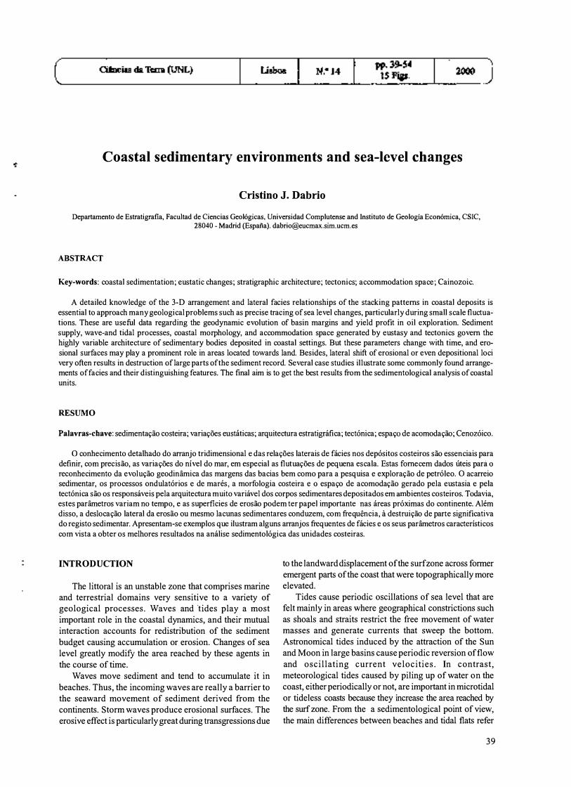
Fig. 1 -Types of eustasy (left) and rates of sea level change (right).
--. . _---- ---- ---_._._--_. - ::::----- :::.:::::::::;:::::::::::::-::
B A regression
transgression
00(----
input ..-
input
L.J marine _ terrestrial L_" co�st (beginning) " coast (end)
C t= 1
eustatic curve
---._--- ----- ---- ---- ,
t= 2 t= 3
Fig. 2 - (A) Sediment input, transgression and regression during a rise of sea level. (B) Superimposition of eustatic curves with variable periodicity and resulting composite curve. (C) Effects upon coastal units of eustatic oscillations with different amplitudes
(modified from Dabrio & Polo, 1 996).
40
tectonic and glacial components of eustasy led to the incorporation of the terms glacio-eustasy and tectonoeustasy. M6rner ( 1976) coined the term geoidal eustasy after measurements from satellites revealed that the irregularity of the geoid also causes eustatic changes. At present it is widely acknowledged that the sea level moves continuously both vertical and horizontally forced by changes in the lithosphere and the hydrosphere and their different velocity of response (Fig. 1). Thus, the term eustasy applies to any change of sea level regardless of it being or not global and coeval. Global factors such as the "glacio-eustatic general sealevel rise" that took place after the Last Glacial Maximum until ca. 7 000 yr. BP (Goy et al., 1996) control the present position of coastlines, but regional factors also contribute significantly to their evolution and trends. In the coasts of the Southern Iberian Peninsula, there are three main regional factors. ( 1) The geographic location (between 36°_40° N and 3°E-9°W) largely controls the weather and climatic trends. (2) The tectonic framework (boundary between the European and African plates) where numerous faults active during the Late Pleistocene and Holocene have affected the coastline producing uplifting or subsidence (Zazo et al., 1994). (3) The effects of the interchange of Atlantic and Mediterranean waters through the Gibraltar Strait.
During eustatic oscillations the coastal environments move laterally tens to hundreds of kilometres and vertically tens to hundreds of metres depositing sedimentary units that very often are disconnected laterally and far away from each other. The laterally shifting high-energy surf and breaker zones cut erosional surfaces. Eustatic falls expose large areas to subaerial erosion.
Apart from presently known possibilities to discriminate the vertical upward and downward relative movement of sea level within sequences of coastal deposits, a more complicated effort is to incorporate the three-dimensional evolution of the shoreline. Another complexity is the determination of the timeframe in which the distinguished patterns of coastal sequences have been formed. Generally, coastal deposits do not easily lend themselves for precise dating of successive depositional steps. Recent and subrecent deposits form an exception, e.g. through 14C dating possibilities. Although sequence stratigraphy helps to distinguish related sediment packets deposited under conditions of varying accommodation space, careful sedimentological analysis should precede a sequence stratigraphic scheme (Van Wagoner & Bertrams, 1995). Even then it is good to keep in mind that the number of variations on the general sequence strati graphic model is limited only by the imagination (Posamentier & Allen, 1993).
EUSTATIC CHANGES AND STRATIGRAPHIC
ARCHITECTURE
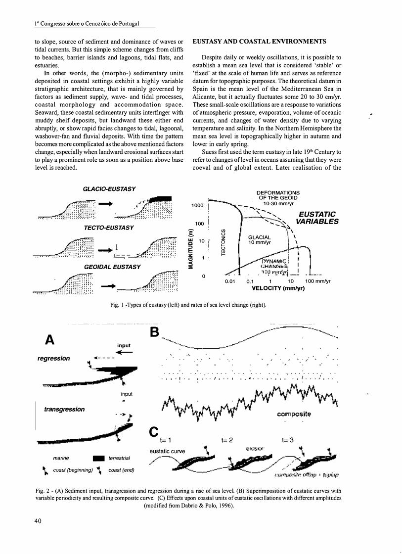
Sea level rises do not necessarily imply transgression and sea-level falls regressions, because these terms refer to lateral shits of the shoreline (the coast indicated in maps)
Ciencias da Terra (UNL), 14
toward the continent or the sea respectively, because another essential element is the sediment supply (Fig. 2A). High input can produce regression with stable or rising sea levels; in contrast, reduced input can favour transgression even with stable sea levels.
Positive eustatic oscillations not always reach the same topographical elevation. This implies that sedimentary units forming an apparently conformable succession of coastal deposits separated by erosional surfaces formed during "sea-level falls" record only a part of eustatic history between the deposition of the oldest and the youngest outcropping units. Most probably the erosional surfaces represent one or more oscillations (Dabrio, Zazo et al., 1996, Zazo et al., 1996). Of course palaeontological or radiometric controls may, at least theoretically, solve this problem, but very often the eustatic events are too rapid as compared to organic evolution, or there are not materials suitable for radiometry. Besides, many eustatic events either leave no recognisable deposits (even if sea levels reached an adequate elevation) or their deposits were eroded later on. Last, but not least, it is not always easy or possible to discriminate between adjacent sedimentary units due to similarity of facies and fossil contents.
As eustatic oscillations take place superimposed at various scales and have diverse wavelengths (Fig. 2B), shifts of the shoreline may look chaotic and the resulting sedimentary record more or less unforeseeable (Fig. 2C). Coastal sediments occur spread on large areas of the basin margins as the shoreline shifts back and forth, and a good part of it is eroded by the moving shoreline, tidal channels and subaerial processes during lowstands.
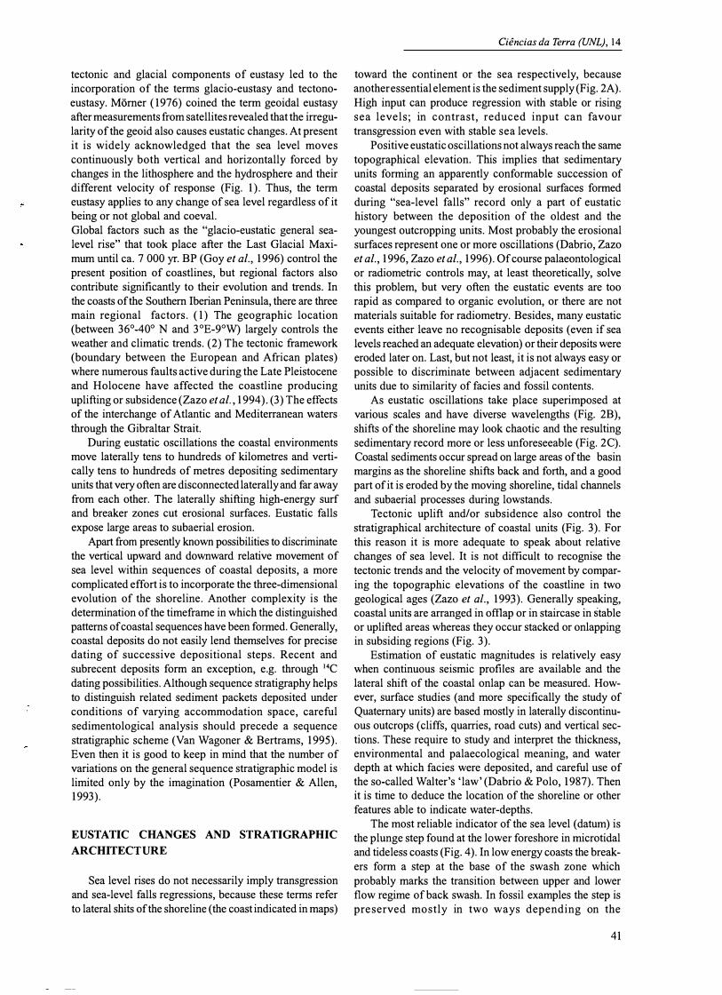
Tectonic uplift and/or subsidence also control the stratigraphical architecture of coastal units (Fig. 3). For this reason it is more adequate to speak about relative changes of sea level. It is not difficult to recognise the tectonic trends and the velocity of movement by comparing the topographic elevations of the coastline in two geological ages (Zazo et aI., 1993). Generally speaking, coastal units are arranged in offlap or in staircase in stable or uplifted areas whereas they occur stacked or onlapping in subsiding regions (Fig. 3).
Estimation of eustatic magnitudes is relatively easy when continuous seismic profiles are available and the lateral shift of the coastal onlap can be measured. However, surface studies (and more specifically the study of Quaternary units) are based mostly in laterally discontinuous outcrops (cliffs, quarries, road cuts) and vertical sections. These require to study and interpret the thickness, environmental and palaecological meaning, and water depth at which facies were deposited, and careful use of the so-called WaIter's 'law' (Dabrio & Polo, 1987). Then it is time to deduce the location of the shoreline or other features able to indicate water-depths.
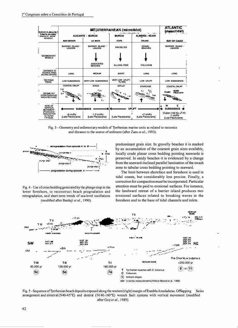
The most reliable indicator of the sea level (datum) is the plunge step found at the lower foreshore in microtidal and tide less coasts (Fig. 4). In low energy coasts the breakers form a step at the base of the swash zone which probably marks the transition between upper and lower flow regime of back swash. In fossil examples the step is preserved mostly in two ways depending on the
41
10 Congresso sobre 0 Cenoz6ico de Portugal
ATLANTIC MEDITERRANEAN (microtidal) I, tOd 1\ B�������s� __________________________ .-__ � ______ -. ______________ -+ __ �\lm�e�s� o�l __ a_'�I (marine-Ierrestrial AUCANTE 0 MURCIA MURCIA ALMERiA 0 NfJAR
transition)
SEDIMENTARY MODELS
DISTANCE TO SOURCE AREA
(ALONG SHORE)
TECTONIC TREND
GEOMETRY (STRATIGRAPHIC ARCHITECTURE)
RATE OF VERTICAL
MOVEMENT (Pleistocene) Deduced from
Tyrrhenian T-lII levels
MARMENOR
BARRIER ISLANDLAGOON
LA MATA
BARRIER ISLAND · LAGOON
ASSOCIATED BEACHES
LONG MEDIUM
LOW SUBSIDENCE VERY LOW SUBSIDENCE
COASTAL ONLAP T-III
""""" T-II �
T·I
"-
STACK
COPE
FAN DELTAS
ALLUVIAL FANS
SHORT
VERY LOW UPLIFT, TILTING
OFFLAP
�" T'"
/��" t
OAUAS
GRAVEL BEACHES
COLLUVIUM
LONG
LOW UPLIFT
STAIRCASE
T-I � � T-II 't//77�'
BAY OF CADIZ BARRIER ISLAND·
LAGOON
LONG
LOW SUBSIDENCE
COASTAL ONLAP
+ W E _ 4 SUBSIDENCE ----I��14 UPUFT ----....,��I+ SUBSIDENCE .. -8cm/Ky I -1.2cm/Ky +2.25cm/Ky I +7cm/Ky OUljienS��=T-III)
(Late Pleistocene) (Late Pleistoeene) (Late Plelstoeene) (Late Pleistocene) (Late Pleistocene)
Fig. 3 - Geometry and sedimentary models ofTyrrhenian marine units as related to tectonics
and distance to the source of sediment (after Zazo et al., 1 993).
I. retrogradation from episode A to B --I erosion��
u�;e�s;e�� - - _ ... . .• ......... ·
B
·.·�
SE
predominant grain size. In gravelly beaches it is marked by an accumulation of the coarsest grain sizes available, locally crude planar cross bedding pointing seawards is preserved. In sandy beaches it is evidenced by a change from the seaward-inclined parallel lamination of the swash zone to tabular cross bedding pointing to seaward.
PIU��� � �� . . .. . .
- . .•.......
·
� ��ALL I I
plunge-step '2 '�'''��:. _.
plunge·step 3 ----- progradatlon during episode A .1
Fig. 4 - Use of cross bedding generated by the plunge-step in the lower foreshore, to reconstruct beach pro gradation and retrogradation, and short-term trends of sea-level oscillations
(modified after Bardaji et al. , 1 990).
+8m �
o
The limit between shoreface and foreshore is used in tidal coasts, but considerably less precise. Finally, a correction for compaction must be incorporated. Particular attention must be paid to erosional surfaces. For instance, the landward retreat of a barrier island produces two erosional surfaces related to breaking waves in the foreshore and to the base of tidal channels and inlets.
HII 95.000 yr Toll
128.000 yr T-I 180.000 yr
AEOLlAN DUNE >250.000 yr ®or@
® � @ T Tyrrhenian beaches with S. bubonius
C Colluvium
® Isotopic stages
uaT U-series measurements (Hillaire-Marcel et aI., 1986)
Fig. 5 - Sequence ofTyrrhenian beach deposits exposed along the western (right) margin ofRambla Amoladeras. Offiapping facies arrangement and sinistral (N40-45°E) and dextral (N1400 1 600E) wrench fault systems with vertical movement (modified
after Goy et al . , 1 989).
42
EVIDENCE OF SE A-LEVEL C H ANGES IN , COARSE-GRAINED BEACH DEPOSITS
One of the best preserved sequences of pro grading Tyrrhenian deposits in the Western Mediterranean is nicely exposed along the western (right) margin of Rambla (wadi) Amoladeras (Zazo et al., 1998). The Last Interglacial (IS 5) is characterised by three sea-level highstands during ISS Se, represented by three marine terraces in Almeria (Zazo et al., 1993) with a mean age of 128 ka (Goy et al., 1986, Hillaire-Marcel et al., 1986), suggesting climatic instability. A marine terrace corresponding to ISS Sc (ca. 95 Ka) is recorded in all coastal sectors, and another marine unit representing ISS Sa (ca. 85 ka) in uplifting trending sectors of Almeria and Alicante.
In RamblaAmoladeras, three Tyrrhenian morpho-sedimentary units correlated with the isotopic stages 7, Se and Sc occur separated by erosional surfaces with beach features and evidence of early cementation (Fig. 5). These units represent highstand facies during the Next to Last and Last Interglacials, and erosional surfaces indicate the intervening falls of sea level. Aeolian dunes separate these units from the underlying units older beach deposits (IS 11 or 9).
Sedimentary units were deposited in gravelly beaches with a warm fauna of Strombus bubonius, between 180 and 100 Ka. The outcrop is affected by a system of normal faults directed N 140- 160oE, that locally produces a displacement of the present coastline. A fault directed N40-60° E controls both the elevations at which beach deposits occur at both sides of the rambla and the sudden inflexions of the present coast.
The offiapping pattern of the morpho-sedimentary units and their variable elevations reflect tectonic activity with mean uplift rates of 0.068 mmlyr. This fact, together with isotopic data, suggest that the sea level during Isotopic Substages Sc, Se, and 7a was very close. Beach deposits
Ciencias da Terra (UNL), 1 4
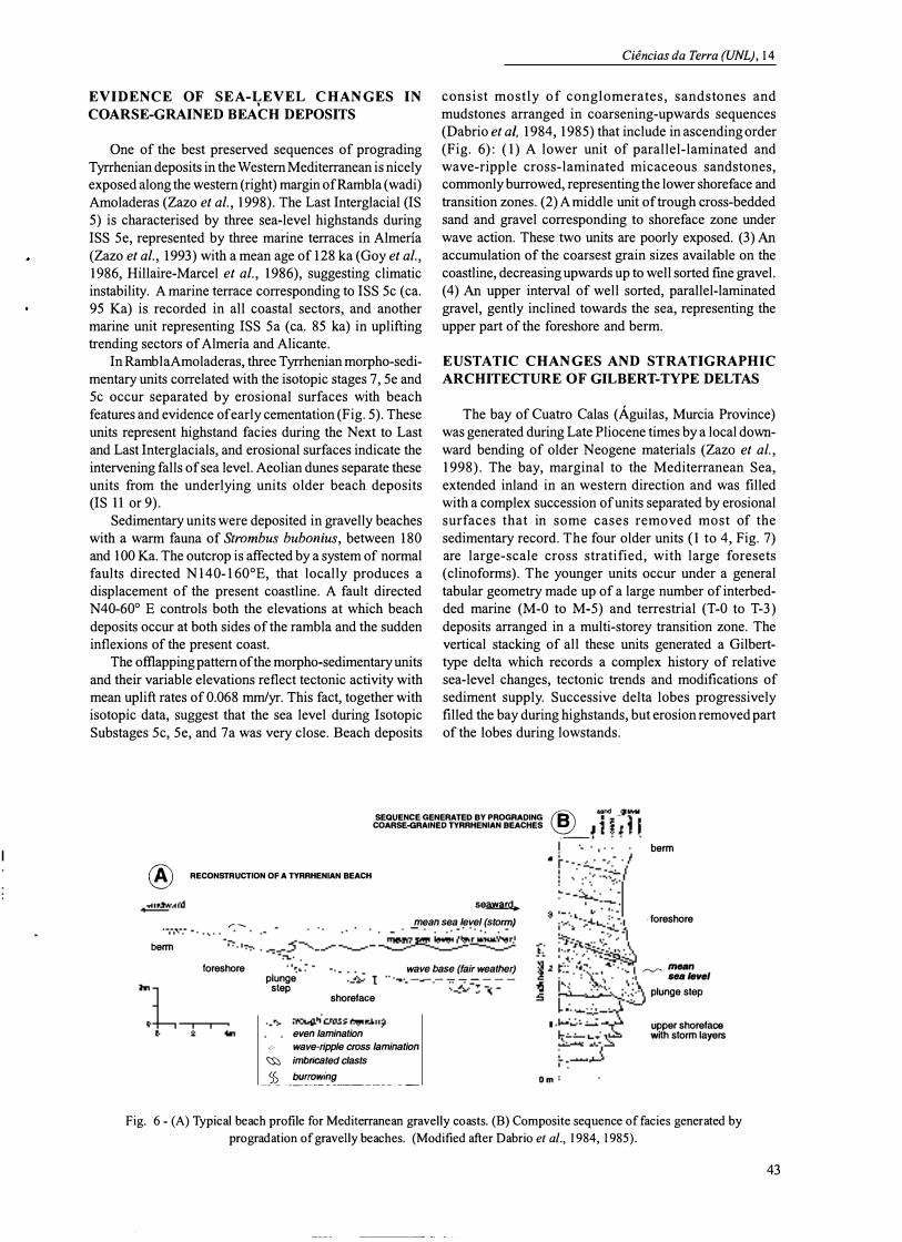
consist mostly of conglomerates, sandstones and mudstones arranged in coarsening-upwards sequences (Dabrio et ai, 1984, 1985) that include in ascending order (Fig. 6): ( 1) A lower unit of parallel-laminated and wave-ripple cross-laminated micaceous sandstones, commonly burrowed, representing the lower shoreface and transition zones. (2) A middle unit of trough cross-bedded sand and gravel corresponding to shoreface zone under wave action. These two units are poorly exposed. (3) An accumulation of the coarsest grain sizes available on the coastline, decreasing upwards up to well sorted fme gravel. (4) An upper interval of well sorted, parallel-laminated gravel, gently inclined towards the sea, representing the upper part of the foreshore and berm.
EUSTATIC CHANGES AND STRATIGRAPHIC
ARCHITECTURE OF GILBERT-TYPE DELTAS
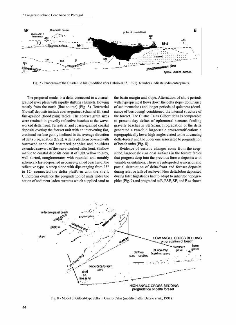
The bay of Cuatro Calas (Aguilas, Murcia Province) was generated during Late Pliocene times by a local downward bending of older Neogene materials (Zazo et aI., 1998). The bay, marginal to the Mediterranean Sea, extended inland in an western direction and was filled with a complex succession of units separated by erosional surfaces that in some cases removed most of the sedimentary record. The four older units ( 1 to 4, Fig. 7) are large-scale cross stratified, with large foresets (clinoforms). The younger units occur under a general tabular geometry made up of a large number of interbedded marine (M-O to M-S) and terrestrial (T-O to T-3) deposits arranged in a multi-storey transition zone. The vertical stacking of all these units generated a Gilberttype delta which records a complex history of relative sea-level changes, tectonic trends and modifications of sediment supply. Successive delta lobes progressively filled the bay during highstands, but erosion removed part of the lobes during lowstands.
® sand V!8VeI SEQUENCE GENERATED BY PROGRADING B --fi - I! COARSE-GRAlNED TYRRHENIAN BEACHES � __ :lJlJJ
® RECONSTRUCTION OF A TYRRHENIAN BEACH
.Iandwa� se�
r � mean sea level (storm) � J '. � - ' - � � - � - ' - ��� ���;�Bt�ry berm � foreshore
plunge step
shoreface
wave base (fair weather) ---------
�trough-cross b8cJding-even lamination
<, wave-ripple cross lamination <;:s::, imbricated clasts
_)� . _����i�� _______ _ _
4
Om
berm
. foreshore
�_mean sea/evel
plunge step
upper shoreface with storm layers
Fig. 6 - (A) Typical beach profile for Mediterranean gravelly coasts. (B) Composite sequence offacies generated by
pro gradation of gravelly beaches. (Modified after Dabrio et al., 1 984, 1 985).
43
10 Congresso sobre 0 Cenoz6ico de Portugal
w Cuartelillo house poles of coastal limit E
Mediterranean sea aprox. 250 m across
Fig. 7 - Panorama of the Cuartelillo hill (modified after Dabrio et aI., 1991). Numbers indicate sedimentary units.
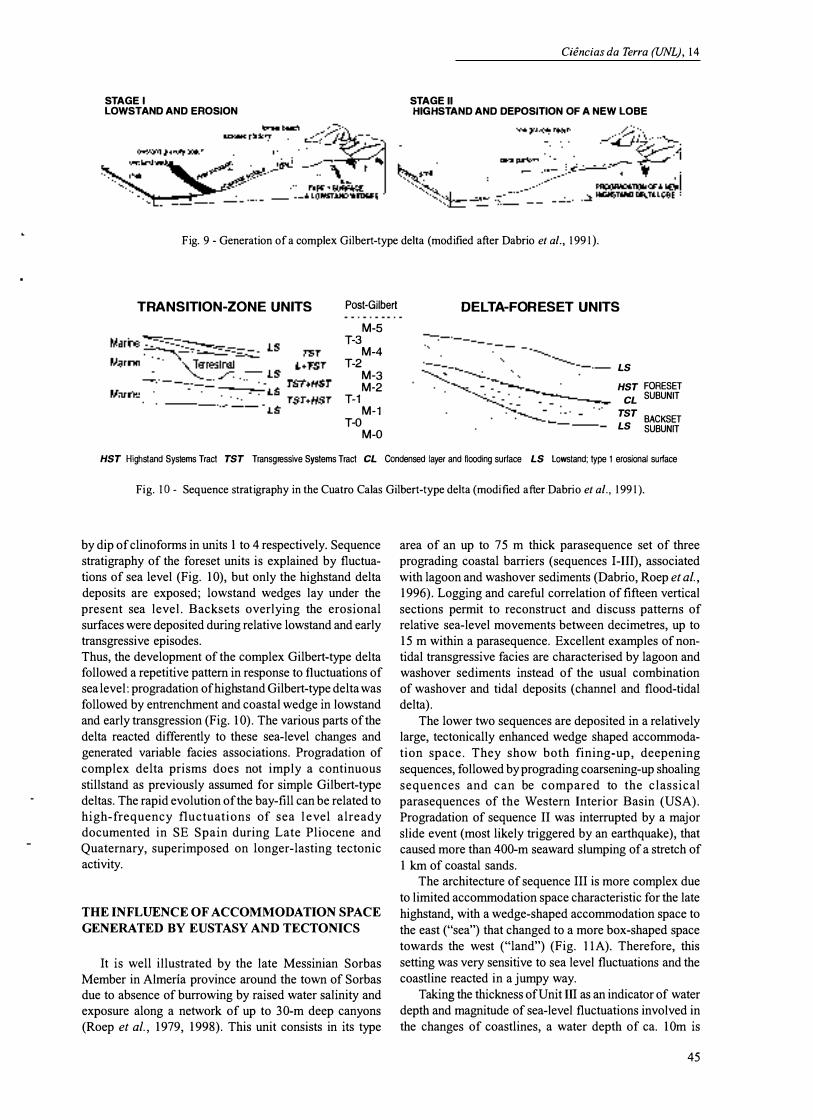
The proposed model is a delta connected to a coarsegrained river plain with rapidly shifting channels, flowing mostly from the north (line source) (Fig. 8). Terrestrial (fluvial) deposits include coarse-grained (channel fill) and fine-grained (flood pain) facies. The coarser grain sizes were retained in gravelly reflective beaches at the waveworked delta front. Terrestrial and coarse-grained coastal deposits overlay the foreset unit with an intervening flat, erosional surface gently inclined in the average direction of delta progradation (ESE). A delta platform covered with burrowed sand and scattered pebbles and boulders extended seaward of the wave-worked delta front. Shallow marine to coastal deposits consist of light yellow to grey, well sorted, conglomerates with rounded and notably spherical clasts deposited in coarse-grained beaches of the reflective type. A steep slope with dips ranging from 25° to 12° connected the delta platform with the shelf. Clinoforms evidence the pro gradation of units under the action of sediment-laden currents which supplied sand to
reflective gravel beach ?J.c'i..\o� �?J.\j� 0
the basin margin and slope. Alternation of short periods with hyperpicnical flows down the delta slope (dominance of sedimentation) and longer periods of quietness (dominance of burrowing) conditioned the internal structure of the foreset. The Cuatro Calas Gilbert delta is comparable to present-day deltas of ephemeral streams feeding gravelly beaches in SE Spain. Progradation of the delta generated a two-fold large-scale cross-stratification: a topographically lower high-angle related to the advancing delta-foreset and the upper one associated to progradation of beach units (Fig. 8).
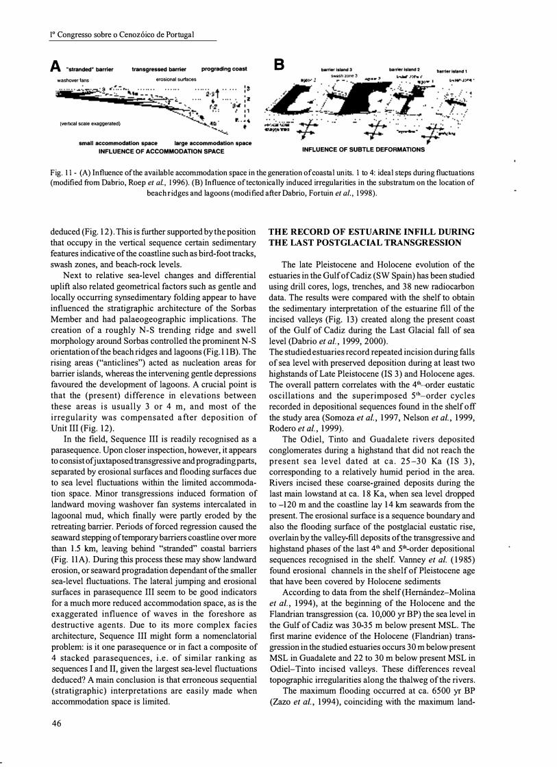
Evidence of eustatic changes come from the seepsided, large-scale erosional surfaces in the foreset facies that progress deep into the previous foreset deposits with variable orientations. These are interpreted as incision and partial destruction of delta-front and foreset deposits during relative falls of sea level. New delta lobes deposited during later highstands had to adapt to inherited topographies (Fig. 9) and pro graded to E, ESE, SE, and E as shown
platform sand + pebbles
LOW ANGLE CROSS BEDDING nrc\nr:::Irl:�ticln of beach
'������;';;-�H�I!G!H�\�A�r�NGLE CROSS BEDDING progradation of delta foreset
Fig. 8 - Model of Gilbert-type delta in Cuatro Calas (modified after Dabrio et al . , 1991).
44
Ciencias da Terra (UNL), 14
STAGE I STAGE 11 LOWSTAND AND EROSION HIGHSTAND AND DEPOSITION OF A NEW LOBE
Fig. 9 - Generation of a complex Gilbert-type delta (modified after Dabrio et al., 1991).
TRANSITION-ZONE UNITS
Marine"""""':::::::-�
Post-Gilbert
M-5 T-3
M-4 T-2
M-3 M-2
T-1 M-1
T-O M-O
DELTA-FORESET UNITS
LS HST FORESET
CL SUBUNIT
TST BACKSET LS SUBUNIT
HST Highstand Systems Tract TST Transgressive Systems Tract CL Ccndensed layer and flooding surface LS Lowstand; type 1 erosional surface
Fig. ID - Sequence stratigraphy in the Cuatro Calas Gilbert-type delta (modified after Dabrio et al., 1991).
by dip of clinoforms in units 1 to 4 respectively. Sequence stratigraphy of the foreset units is explained by fluctuations of sea level (Fig. 10), but only the highstand delta deposits are exposed; lowstand wedges lay under the present sea level. Backsets overlying the erosional surfaces were deposited during relative lowstand and early transgressive episodes. Thus, the development of the complex Gilbert-type delta followed a repetitive pattern in response to fluctuations of sea level: progradation of high stand Gilbert-type delta was followed by entrenchment and coastal wedge in lowstand and early transgression (Fig. 10). The various parts of the delta reacted differently to these sea-level changes and generated variable facies associations. Progradation of complex delta prisms does not imply a continuous still stand as previously assumed for simple Gilbert-type deltas. The rapid evolution of the bay-fill can be related to high-frequency fluctuations of sea level already documented in SE Spain during Late Pliocene and Quaternary, superimposed on longer-lasting tectonic activity.
THE INFLUENCE OF ACCOMMODATION SPACE
GENERATED BY EUSTASY AND TECTONICS
It is well illustrated by the late Messinian Sorbas Member in Almeria province around the town of Sorbas due to absence of burrowing by raised water salinity and exposure along a network of up to 30-m deep canyons (Roep et aI., 1979, 1998). This unit consists in its type
area of an up to 75 m thick parasequence set of three prograding coastal barriers (sequences I-Ill), associated with lagoon and washover sediments (Dabrio, Roep et al., 1996). Logging and careful correlation of fifteen vertical sections permit to reconstruct and discuss patterns of relative sea-level movements between decimetres, up to 15 m within a parasequence. Excellent examples of nontidal transgressive facies are characterised by lagoon and washover sediments instead of the usual combination of washover and tidal deposits (channel and flood-tidal delta).
The lower two sequences are deposited in a relatively large, tectonic ally enhanced wedge shaped accommodation space. They show both fining-up, deepening sequences, followed by prograding coarsening-up shoaling sequences and can be compared to the classical parasequences of the Western Interior Basin (USA). Pro gradation of sequence 11 was interrupted by a major slide event (most likely triggered by an earthquake), that caused more than 400-m seaward slumping of a stretch of 1 km of coastal sands.
The architecture of sequence III is more complex due to limited accommodation space characteristic for the late highstand, with a wedge-shaped accommodation space to the east ("sea") that changed to a more box-shaped space towards the west ("land") (Fig. lIA). Therefore, this setting was very sensitive to sea level fluctuations and the coastline reacted in a jumpy way.
Taking the thickness of Unit III as an indicator of water depth and magnitude of sea-level fluctuations involved in the changes of coastlines, a water depth of ca. 10m is
45
10 Congresso sobre 0 Cenoz6ico de Portugal
A "stranded" barrier
washover fans
(vertical scale exaggerated}
transgressed barrier erosional surfaces
prograding coast
small accommodation space large accommodation space INFLUENCE OF ACCOMMODATION SPACE
B barrier island 3 swash zone 3
barr�r island 2
INFLUENCE OF SUBTLE DEFORMATIONS
barrier island 1
Fig. 11 - (A) Influence ofthe available accommodation space in the generation of coastal units. 1 to 4: ideal steps during fluctuations (modified from Dabrio, Roep et al., 1 996). (B) Influence oftectonically induced irregularities in the substratum on the location of
beach ridges and lagoons (modified after Dabrio, Fortuin et al. , 1 998).
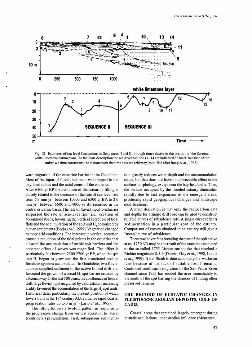
deduced (Fig. 12). This is further supported by the position that occupy in the vertical sequence certain sedimentary features indicative of the coastline such as bird-foot tracks, swash zones, and beach-rock levels.
Next to relative sea-level changes and differential uplift also related geometrical factors such as gentle and locally occurring synsedimentary folding appear to have influenced the stratigraphic architecture of the Sorbas Member and had palaeogeographic implications. The creation of a roughly N-S trending ridge and swell morphology around Sorbas controlled the prominent N-S orientation of the beach ridges and lagoons (Fig. 1IB). The rising areas ("anticlines") acted as nucleation areas for barrier islands, whereas the intervening gentle depressions favoured the development of lagoons. A crucial point is that the (present) difference in elevations between these areas is usually 3 or 4 m, and most of the irregularity was compensated after deposition of Unit III (Fig. 12).
In the field, Sequence III is readily recognised as a parasequence. Upon closer inspection, however, it appears to consist of juxtaposed transgressive and prograding parts, separated by erosional surfaces and flooding surfaces due to sea level fluctuations within the limited accommodation space. Minor transgressions induced formation of landward moving washover fan systems intercalated in lagoonal mud, which finally were partly eroded by the retreating barrier. Periods of forced regression caused the seaward stepping of temporary barriers coastline over more than 1.5 km, leaving behind "stranded" coastal barriers (Fig. 11A). During this process these may show landward erosion, or seaward pro gradation dependant of the smaller sea-level fluctuations. The lateral jumping and erosional surfaces in parasequence III seem to be good indicators for a much more reduced accommodation space, as is the exaggerated influence of waves in the foreshore as destructive agents. Due to its more complex facies architecture, Sequence III might form a nomenclatorial problem: is it one parasequence or in fact a composite of 4 stacked parasequences, i.e. of similar ranking as sequences I and 11, given the largest sea-level fluctuations deduced? A main conclusion is that erroneous sequential (stratigraphic) interpretations are easily made when accommodation space is limited.
46
THE RECORD OF ESTUARINE INFILL DURING
THE LAST POSTGLACIAL TRANSGRESSION
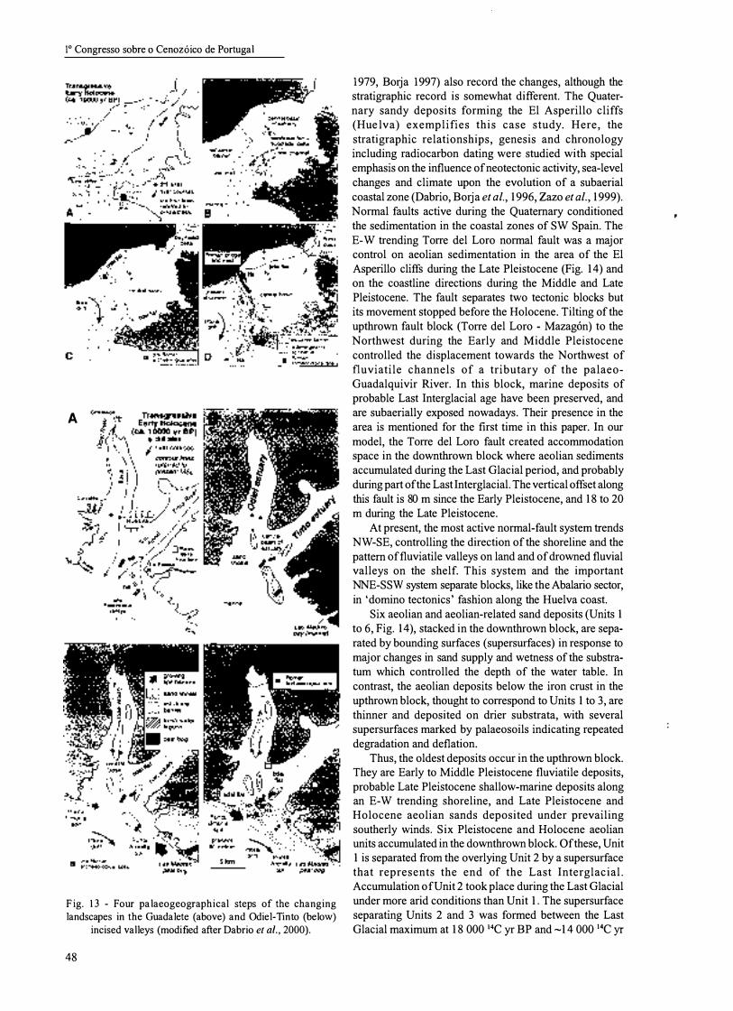
The late Pleistocene and Holocene evolution of the estuaries in the Gulf ofCadiz (SW Spain) has been studied using drill cores, logs, trenches, and 38 new radiocarbon data. The results were compared with the shelf to obtain the sedimentary interpretation of the estuarine fill of the incised valleys (Fig. 13) created along the present coast of the Gulf of Cadiz during the Last Glacial fall of sea level (Dabrio et at., 1999, 2000). The studied estuaries record repeated incision during falls of sea level with preserved deposition during at least two highstands of Late Pleistocene (IS 3) and Holocene ages. The overall pattern correlates with the 4th-order eustatic oscillations and the superimposed 5th-order cycles recorded in depositional sequences found in the shelf off the study area (Somoza et al., 1997, Nelson et at., 1999, Rodero et al., 1999).
The Odiel, Tinto and Guadalete rivers deposited conglomerates during a highstand that did not reach the present sea level dated at ca. 25-30 Ka (IS 3), corresponding to a relatively humid period in the area. Rivers incised these coarse-grained deposits during the last main lowstand at ca. 18 Ka, when sea level dropped to -120 m and the coastline lay 14 km seawards from the present. The erosional surface is a sequence boundary and also the flooding surface of the postglacial eustatic rise, overlain by the valley-fill deposits of the transgressive and highstand phases of the last 4th and 5th-order depositional sequences recognised in the shelf. Vanney et al. ( 1985) found erosional channels in the shelf of Pleistocene age that have been covered by Holocene sediments
According to data from the shelf (Hernandez-Molina et at., 1994), at the beginning of the Holocene and the Flandrian transgression (ca. 10,000 yr BP) the sea level in the Gulf of Cadiz was 30-35 m below present MSL. The first marine evidence of the Holocene (Flandrian) transgression in the studied estuaries occurs 30 m below present MSL in Guadalete and 22 to 30 m below present MSL in Odiel-Tinto incised valleys. These differences reveal topographic irregularities along the thalweg of the rivers.
The maximum flooding occurred at ca. 6500 yT BP (Zazo et at., 1994), coinciding with the maximum land-
0 2
50m
0 250 500
0 10
20 30 40 50
m
750 1000
white limestone layer
SEQUENCE 11 SEQUENCE III
Ciencias da Terra (UNL), 14
11
5
Time ..
Fig. 1 2 - Estimates of sea-level fluctuations in Sequences II and III through time relative to the position ofthe Zorreras white limestone datum plane. To facilitate description the sea-level positions 1-14 are indicated on inset. Because ofthe
unknown time constraints the distances on the time axis are arbitrary (modified after Roep et al., 1 998).
ward migration of the estuarine barrier in the Guadalete. Most of the input of fluvial sediment was trapped in the bay-head deltas and the axial zones of the estuaries. After 6500 yr BP the evolution of the estuarine filling is closely related to the decrease of the rate of sea-level rise from 5.7 mm yr.1 between 10000 and 6500 yr BP, to 2.6 mm yr.1 between 6500 and 4000 yr BP recorded in the central estuarine basin. The rate of fluvial input to estuaries surpassed the rate of sea-level rise (i.e., creation of accommodation), favouring the vertical accretion of tidal flats and the accumulation of the spit unit H2 colonised by human settlements (Borja et al., 1999). Vegetation changed to more arid conditions. The increase in vertical accretion caused a reduction of the tidal prisms in the estuaries that allowed the accumulation of stable spit barriers and the apparent effect of waves was magnified. The effect is particularly felt between 2500-2700 yr BP, when the spit unit H3 began to grow and the first associated aeolian foredune systems accumulated. In Guadalete, two fluvial courses supplied sediment to the active littoral drift and favoured the growth of a broad H3 spit barrier crossed by a Roman way. In the last 500 years, the confluence of littoral drift, large fluvial input magnified by deforestation, increasing aridity favoured the accumulation of the large H
4 spit units.
Historical data, particularly the present position of watch towers built in the 17th century AD, evidence rapid coastal progradation rates up to 3 m yrl (Lario et al., 1995).
The filling follows a twofold pattern in response to the progressive change from vertical accretion to lateral (centripetal) progradation. First, subaqueous sedimenta-
tion greatly reduces water depth and the accommodation space, but that does not have an appreciable effect in the surface morphology, except near the bay-head delta. Then, the surface occupied by the flooded estuary diminishes rapidly due to fast expansion of the emergent areas, producing rapid geographical changes and landscape modifications.
A main derivation is that only the radiocarbon data and depths for a single drill core can be used to construct reliable curves of subsidence rate. A single curve reflects sedimentation in a particular spot of the estuary. Comparison of curves obtained in an estuary will give a "mean" curve of subsidence.
Three washover fans breaking the part of the spit active at ca. 1750 AD may be the result of the tsunami associated to the so-called 1755 Lisbon earthquake that reached a Richter magnitude 8.5-9 (Dabrio, Goy et al., 1998 , Luque et al., 1999). It is difficult to date accurately the washover fans because of the lack of suitable fossil remains. Continued southwards migration of the San Pedro River channel since 1755 has eroded the area immediately to the south of the spit barring the chances of finding other preserved remains.
THE RECORD OF EUSTATIC CHANGES IN
PLEISTOCENE AEOLIAN DEPOSITS, GULF OF
CADIZ
Coastal areas that remained largely emergent during eustatic oscillations under aeolian influence (Menanteau,
47
10 Congresso sobre 0 Cenoz6ico de Portugal
A
Skm
Fig. 13 - Four palaeogeographical steps of the changing landscapes in the Guadalete (above) and Odiel-Tinto (below)
incised valleys (modified after Dabrio et al., 2000).
48
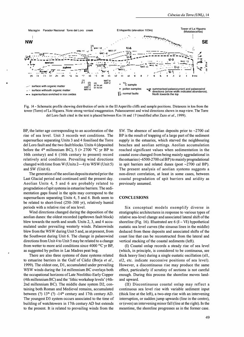
1979, Borja 1997) also record the changes, although the stratigraphic record is somewhat different. The Quaternary sandy deposits forming the El Asperillo cliffs (Hue Iv a) exemplifies this case study. Here, the stratigraphic relationships, genesis and chronology including radiocarbon dating were studied with special emphasis on the influence of neotectonic activity, sea-level changes and climate upon the evolution of a subaerial coastal zone (Dabrio, Borja et al., 1996, Zazo et al., 1999). Normal faults active during the Quaternary conditioned the sedimentation in the coastal zones of SW Spain. The E-W trending Torre del Loro normal fault was a major control on aeolian sedimentation in the area of the El Asperillo cliffs during the Late Pleistocene (Fig. 14) and on the coastline directions during the Middle and Late Pleistocene. The fault separates two tectonic blocks but its movement stopped before the Holocene. Tilting of the upthrown fault block (Torre del Loro - Mazag6n) to the Northwest during the Early and Middle Pleistocene controlled the displacement towards the Northwest of fluviatile channels of a tributary of the palaeoGuadalquivir River. In this block, marine deposits of probable Last Interglacial age have been preserved, and are subaerially exposed nowadays. Their presence in the area is mentioned for the first time in this paper. In our model, the Torre del Loro fault created accommodation space in the downthrown block where aeolian sediments accumulated during the Last Glacial period, and probably during part of the Last Interglacial. The vertical offset along this fault is 80 m since the Early Pleistocene, and 18 to 20 m during the Late Pleistocene.
At present, the most active normal-fault system trends NW-SE, controlling the direction of the shoreline and the pattern of fluviatile valleys on land and of drowned fluvial valleys on the shelf. This system and the important NNE-SSW system separate blocks, like the Abalario sector, in 'domino tectonics' fashion along the Huelva coast.
Six aeolian and aeolian-related sand deposits (Units 1 to 6, Fig. 14), stacked in the downthrown block, are separated by bounding surfaces (supersurfaces) in response to major changes in sand supply and wetness of the substratum which controlled the depth of the water table. In contrast, the aeolian deposits below the iron crust in the upthrown block, thought to correspond to Units 1 to 3, are thinner and deposited on drier substrata, with several supersurfaces marked by palaeosoils indicating repeated degradation and deflation.
Thus, the oldest deposits occur in the upthrown block. They are Early to Middle Pleistocene fluviatile deposits, probable Late Pleistocene shallow-marine deposits along an E-W trending shoreline, and Late Pleistocene and Holocene aeolian sands deposited under prevailing southerly winds. Six Pleistocene and Holocene aeolian units accumulated in the downthrown block. Of these, Unit 1 is separated from the overlying Unit 2 by a supersurface that represents the end of the Last Interglacial. Accumulation of Unit 2 took place during the Last Glacial under more arid conditions than Unit 1. The supersurface separating Units 2 and 3 was formed between the Last Glacial maximum at 18 000 14C yr BP and -14 000 14C yr
Mazagon Parador Nacional Torre del Loro creek
I NW
... ".. surface with organic matter
.• ' surface withouth organic matter
-. supersurface enriched in iron oxides
(1) MAT-9 Z-1 (2) (4) ASP-2 (3) al to a4 ASP-l bl to b4 MAT-S
Ciencias da Terra (UNL), 14
E l Asperillo (elevation 103m) Tower of La Higuera
(Matalascaiias)
• 1"c sample
* pollen samples
\ \� normal faults
I SE
o::;t" summarised palaeocurrent and palaeowind directions (arrow width indicates abundance). North towards the top
Fig. 14 - Schematic profile showing distribution of units in the El Asperillo cliffs and sample positions. Distances in km from the tower (Torre) of La Higuera. Note strong vertical exaggeration. Palaeocurrent and wind directions shown in map view. The Torre
del Loro fault cited in the text is placed between Km 1 6 and 17 (modified after Zazo et al., 1 999).
BP, the latter age corresponding to an acceleration of the rise of sea level. Unit 3 records wet conditions. The supersurface separating Units 3 and 4 fossilised the Torre del Loro fault and the two fault blocks. Units 4 (deposited before the 4th millennium BC), 5 (> 2700 14C yr BP to 16th century) and 6 (l6th century to present) record relatively arid conditions. Prevailing wind directions changed with time from W (Units 2-4) to WSW (Unit 5) and SW (Unit 6).
The generation of the aeolian deposits started prior the Last Glacial period and continued until the present day. Aeolian Units 4, 5 and 6 are probably related to progradation of spit systems in estuarine barriers. The sedimentation gaps found in the spits may correspond to the supersurfaces separating Units 4, 5 and 6. Both seem to be related to short-lived (250-300 yr), relatively humid periods with a relative rise of sea level.
Wind directions changed during the deposition of the aeolian dunes: the oldest recorded (upthrown fault block) blew towards the north and south. Units 2, 3, and 4 accumulated under prevailing westerly winds. Palaeowinds blew from the WSW during Unit 5 and, as at present, from the Southwest during Unit 6. The change in palaeowind directions from Unit 4 to Unit 5 may be related to a change from wetter to more arid conditions since 4000 14C yr BP, as suggested by pollen in Las Madres peat bog.
There are also three systems of dune systems related to estuarine barriers in the Gulf of Oidiz (Borja et al., 1999). The oldest one, D 1, accumulated under prevailing WSW winds during the 1 st millennium BC overlays both the occupational horizons of Late Neolithic-Early Copper (4th millennium BC) and the 'lithic workshop levels' (4th-2nd millennium BC). The middle dune system D2, containing both Roman and Medieval remains, accumulated between (?) 13th (?) _14th century and 17th century AD. The youngest D3 system occurs associated to the time of building of watchtowers in 17th century AD but extends to the present. It is related to prevailing winds from the
Sw. The absence of aeolian deposits prior to -2700 cal BP is the result of trapping of a large part of the sediment supply in the estuaries, which starved the neighbouring beaches and aeolian settings. Aeolian accumulation reached significant values when sedimentation in the coastal zone changed from being mainly aggradational in the estuaries (-6500-2700 cal BP) to mainly progradational in spit barriers and related dunes (post -2700 cal BP). The present analysis of aeolian systems suggests a non-direct correlation, at least in some cases, between coastal progradation of spit barriers and aridity as previously assumed.
CONCLUSIONS
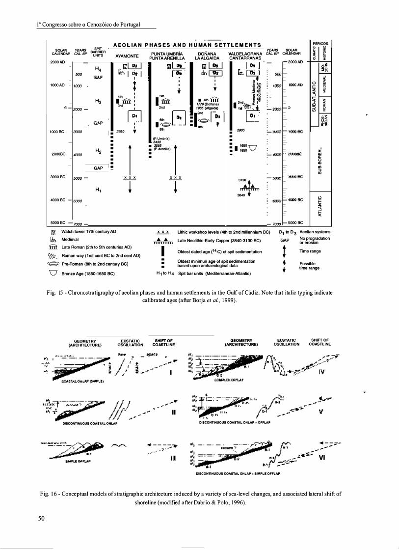
Six conceptual models exemplify diverse in strati graphic architectures in response to various types of relative sea-level change and associated lateral shift of the shoreline (Fig. 16). Illustrated are 6 (I - VI) hypothetical eustatic sea level curves (the sinuous lines in the middle) deduced from these deposits and associated shifts of the coast line that can be reconstructed from the lateral and vertical stacking of the coastal sediments (left).
(I) Coastal onlap records a steady rise of sea level (which, in principle, is considered to be continuous, see thick heavy line) during a single eustatic oscillation (s11, s12, etc. indicate successive positions of sea level). However, a discontinuous rise may produce the same effect, particularly if scrutiny of sections is not careful enough. During this process the shoreline moves landand upward.
(11) Discontinuous coastal onlap may reflect a continuous sea level rise with variable sediment input (thick line at the left), a two-step rise with an intervening interruption, or sudden jump upwards (line in the centre), or (even) an intervening minor fall (line at the right). In the meantime, the shoreline progresses as in the former case.
49
10 Congresso sobre 0 Cenoz6ico de Portugal
SOLAR YEARS CALENDAR CAL.BP
2000AD _ --=
�= 500 -- = 1000AD -= 1000 -= :: -
= ::: -0-2000 -= =
-= --1000BC -3000 ...::.
- -
2000BC -4000 ---
3000 BC - 5000 -- �-
4000 BC -6000 -= --
5000 BC - 7000
AEOLlAN SPIT
BARRIER UNITS AYAMONTE
l'nil!!J H4 � � ._!3�E_
: I 4th I
H3 • fill I 3rd I I 6 - §� - I I
• 2950 , • • •
I H2
• • • • • • GAP -
x x x
H1 !
l'ni Watch tower 17th century AD
� Medieval
fill Late Roman (21h to 5th centuries AD)
� Roman way (1 rst cent BC to 2nd cent AD)
� Pre-Roman (8th to 2nd century BC)
V Bronze Age (1850-1650 BC)
PHASES AND HUMAN SETTLEMENT S PUNTA UMBRiA
PUNTA ARENILLA
l'ni� t�1 I I I ,
fim 2nd mh � I<g> 8th
(P.Umbrla) 3430
.- 3555
I • (P .Arenilla)
• •
x x x
!
DONANA LA ALGAIDA
l'ni� �0f!J I I , • 4th fill
1770 (Donana) 1965 (AJgaida)
·rd � :�
VALDELAGRANA CANTARRANAS
� �� .. � I� jlE � I� � :� I:�,
2905 • • • :. t650 V • t850 -
3� AA 3840
YEARS SOLAR CAL.BP CALENDAR
2000 AD ---
- 500 ---- 1000 �1OOOAD ----- --�-'::"'2000 �O ----- -� ---3000 �1000BC ----- -----4000 t--2000BC
-f- -----f-5ooo �3000BC --
-f- -----6000 t--4000 BC ----- --� 7000 � 5000 BC
PERIODS Q 0 !< it " g :::; '" 0 "f
6� ::;;W � ...J � Q W
i= B z W " ::s -!;t: Z cD « ::;; => 0 en a: -
'Z �Q
_"-z
-' <I: w a: 0 m cD => en
Q i= Z ::s !;t:
� Lithic workshop levels (4th to 2nd millennium BC) 01 to D 3 Aeolian systems
AA Late Neol�hic-Ea�y Copper (3840-3130 BC) GAP No progradation TTTTTTTTTTl or erosion
I Oldest dated age (14 C) of spit sedimentation t TIme range
• Oldest minimun age of spit sedimentation • • Possible • based upon archaeological data • time range H1 toH4 Spit bar un� (Mediterranean-Atlantic)
Fig. 15 - Chronostratigraphy of aeolian phases and human settlements in the Gulf ofCadiz. Note that italic typing indicate
calibrated ages (after Borja et al., 1 999).
GEOMETRY (ARCHITECTURE) EUSTATIC OSCILLATION
SHIFT OF COASTLINE
sll sl2 s�
GEOMETRY (ARCHITECTURE) EUSTATIC OSCILLATION
Sl4 -,----.. -,:: sl5 ."""C::::::::::::::'::: :::::.::::::::'::::: '11-2
SHIFT OF COASTLINE
OO�';;�II?//'--< DISCONTINUOUS COASTAL ONLAP + OFFLAP DISCONTINUOUS COASTAL QNLAP
. - ;:;;:' ...... ...... ... .-s�-
-- VI .......... --..... -...... -DISCONTINUOUS COASTAL ONLAP + SIMPLE OFFLAP
Fig. 1 6 - Conceptual models of stratigraphic architecture induced by a variety of sea-level changes, and associated lateral shift of
shoreline (modified after Dabrio & Polo, 1 996).
50
•
(Ill) Coastal offlap records (quasi) steady sea level. Seaward shift of shoreline may (or may not) be preceded by other shifts (dotted line with question mark).
(IV) A complex coastal offlap with three pro grading beach units (B- 1, B-2, B-3) at different topographic elevations, each composed of minor prograding units (a, b, c), records at least a first sea level rise followed by eustatic oscillations reaching progressively lower elevations. The shoreline follows a zigzagging pattern.
(V) Two beach units (B-1 older than B-2), each with minor offlapping units (a, b, c) record at least two sea-level maxima reaching progressively higher elevations, with an intervening still stand, or minor fall that complete these oscillations. The shoreline follows a zigzagging pattern.
(VI) A combination of former cases may produce much more complex strati graphical architectures, such as in the discontinuous coastal onlap plus simple offlap.
These models can be applied to the former case studies but it must be noted that differentiation in the field between situation IV and V may be difficult when the boundaries are incompletely exposed. Furthermore, the lateral and vertical relationships are much more complicated due to the interplay of various orders of magnitude of sea level changes.
REFERENCES
Ciencias da Terra (UNL), 1 4
The cases of gravelly beaches in Rambla Amoladeras and the Gilbert-type delta of Cuatro Calas are classified as type IV forming a complex offlap of several units separated by erosional surfaces. The main difference between the two situations is that tectonic uplift was more prominent in Amoladeras.
Situations I, 11 and I II and their combination in example VI all can be found in sequence 11 of Sorbas, whereas examples IV and V can be found in sequence Ill.
Situation V I applies to the post-glacial eustatic rise in SW Iberian Peninsula. Here, limited progradation of lithosomes during temporary stops or times of reduced rate of rise in terminal Pleistocene times produce discontinuous coastal onlap plus offlap (V), whereas progradation with quasi stable sea level in Holocene promotes simple offlap (Ill).
ACKNOWLEDGEMENTS
Financial support from Spanish MEC projects PB98 -0514 and PB98-0265, and ProjectAreces: "Cambios climaticos y nivel del mar". It is a contribution to IGCP 437.
Bardaji, T.; Dabrio, C. J.; Goy, J. L.; Somoza, L. & Zazo, C. ( 1990) - Pleistocene fan deltas is southeastern Iberian Peninsula: sedimentary controls and sea level changes. Spec. PubIs. Int. Ass. Sediment., 1 0: 1 29- 1 5 1 .
Borja, F. ( 1 997) - Dunas litorales de Huelva (SW de Espafia) Tipologia y secuencias Pleistoceno Superior-Holoceno. In: RodriguezVidal, J. (Ed.), Cuaternario Iberico, Universidad de Huelva, 84-97.
Borja, F.; Zazo, C.; Dabrio, C.J.; Diaz del Olmo, F.; Goy, J.L. & Lario, J. ( 1 999) - Holocene aeolian phases and human settlements along the Atlantic coast of southern Spain. The Holocene 9 (3): 333-339.
Dabrio, C.J.; Bardaji, T. ; Zazo, C. & Goy, J.L. ( 199 1 ) - Effects of sea-level changes on a wave-worked Gilbert-type delta (Late Pliocene, Aguilas Basin, SE Spain). Cuadernos de Geologia Iberica, 1 5 : 1 03- 137 .
Dabrio, c.J.; Borja, F.; Zazo, C.; Boersma, J.R.; Lario, J . ; Goy, J.L. & Polo, M.D. ( 1 996) - Dunas eolicas y facies asociadas pleistocenas y holocenas en el acantilado del Asperillo (Huelva). Geogaceta 20 (5): 1 089- 1 092.
Dabrio, C. J.; Fortuin, A.R.; Polo, M. D. & Roep, T.B. ( 1 998) - Subtle controls of sedimentation and sequence stratigraphy of coastal settings: the Late Messinian Sorbas Member (SE. Spain). In: Cafiaveras, J.C., Garcia del Cura, M.A. and Soria, J. (Eds.), Sedimentology at the dawn of the Third Millennium. Abstracts. Publicaciones de la Universidad de Alicante: 279-28 1 .
Dabrio, C.J.; Goy, J.L. & Zazo, C. ( 1 984) - Dimimica litoral y ambientes sedimentarios en el Golfo de Almeria desde el «Tirreniense» a la actualidad. I Congreso Espaiiol de Geologia, I: 507-522.
Dabrio, c.J.; Goy, J.L. & Zazo, C. ( 1985) - A model of conglomeratic beaches in tectonically active areas (Late Pleistocene-actual, Almeria, Spain). 6th European Meeting ofSedimentology LA.S.: 1 04- 1 07.
Dabrio, C.J.; Goy, J.L. & Zazo, C. ( 1998) - The record ofthe tsunami produced by the 1 755 Lisbon earthquake in Valdelagrana spit (Gulf ofCadiz, southern Spain). Geogaceta 23: 3 1 -34.
Dabrio, C.J. & Polo, M.D. ( 1 987) - Holocene sea-level changes, coastal dynamics and human impacts in southern Iberian Peninsula. In: Zazo, C. (Ed.), Late Quaternary Sea-level Changes in Spain. Museo Nal. Ciencias Naturales, CSIC., 1 0: 227-247.
Dabrio, c.J. & Polo, M.D. ( 1996) - Cambios eustaticos y arquitectura estratigrafica de unidades costeras. Geogaceta 20 (3): 438-44 1 .
5 1
10 Congresso sobre 0 Cenozoico de Portugal
Dabrio, e.J.; Roep, T.B.; Polo, M.D. & Fortuin, A.R. ( 1996) - Late Messinian coastal barrier and washover fan sedimentation in Sorbas (SE Spain). Geogaceta, 2 1 : 9 1 -94.
Dabrio, e.J.; Zazo, e.; Goy, J.L.; Sierro, F.J.; Borja, F.; Lario, J.; Gonzalez, J.A. & Flores, J.A. (2000) - Depositional history of estuarine infill during the last postglacial transgression (Gulf ofCadiz, southern Spain). Mar. Geol., 1 62: 3 8 1 -404.
Dabrio, CJ.; Zazo, e.; Lario, J.; Goy, J.L.; Sierro, FJ.; Borja, F.; Gonzalez, J.A. & Flores, J.A. ( 1999) - Sequence stratigraphy of Holocene incised-valley fills and coastal evolution in the GulfofCadiz (southern Spain). Geol. Mijn., 77: 209-224.
Dabrio, e.J.; Zazo, C.; Somoza, L.; Goy, J.L.; Bardaji, T.; Lario, J. & Silva, P.G ( 1996) - Oscilaciones del mar de largo y corto plazo: indicadores morfosedimentarios en zonas costeras. Geogaceta, 20 (5): 1078- 1 079.
Goy, J.L.; Zazo, C.; Dabrio, e.J.; Lario, J.; Borja, F.; Sierro, F.J. & Flores, J.A. ( 1996) - Global and regional factors controlling changes of coastlines in southern Iberia (Spain) during the Holocene. Quaternary Sci. Rev., 1 5 : 773-780.
Goy, J.L.; Zazo, C.; Hillaire-Marcel, e. & Causse, e. ( 1986) - Stratigraphie et chronologie (U/Th) del TyrreMnien du SE de L'Espagne. Zeitschriftfiir Geomorphology, 62: 7 1 -82.
Goy, lL.; Zazo, c.; Somoza, L.; Dabrio, e.l & Bardaji, T. ( 1989) - Litoral Beticas orientales. In: , Excursion B-1 litoral Meditemineo (Ed. by C. Zazo, C.J. Dabrio, J.L. Goy), 2" Reunion del Cuaternario Iberico, Sept. 1 989, Editorial E. T.S. Ing. Industriales, Madrid: 37-98.
Hernandez-Molina, F.J. ; Somoza, L.; Rey, l & Pomar, L. ( 1994) - Late Pleistocene-Holocene sediments on the Spanish continental shelves: a model for very high-resolution sequence stratigraphy. Mar. Geol. , 1 20: 1 29- 1 74.
Hillaire-Marcel, C.; Carro, 0.; Causse, e.; Goy, J.L. & Zazo, e. ( 1986) - Th/u dating ofStrombus bubonius-bearing marine terraces in southeastern Spain. Geology, 14: 6 1 3-6 16.
Lario, J . ; Zazo, C.; Dabrio, C.J. ; Somoza, L. ; Goy, J.L.; Bardaji, T. & Silva, P.G ( 1 995) - Record of recent Holocene sediment input on spit bars and deltas of south Spain. J. Coastal Res., Spec. Issue 17 : 241 -245.
Luque, L.; Zazo, C.; Goy, J. L.; Dabrio, C.J.; Civis, J.; Lario, J. & Gomez Ponce, C. ( 1 999) - Los depositos del tsunami de Lisboa de 1755. Su registro en la Bahia de Cadiz: Flecha de Valdelagrana (Espafia). In : Palli, L and Roque, C (Eds.) Avances en el estudio del Cuaternario espafiol. AEQUA: 63-66.
Menanteau, L. ( 1979) - Les marismes du Guadalquivir. Example de transformation d 'un paysage alluvial au cours du Quaternaire recent. These 3eme cycle, Universite Paris Sorbonne, 1 54 pp.
Miirner, N. A. ( 1 976) - Eustasy and geoid changes. J. Geol., 84: 123- 152.
Nelson, e.H.; Baraza, J.; Maldonado, A.; Rodero, J.; Escutia, e. & Baraber, J.H. ( 1 999) - Influence of the Atlantic inflow and Mediterranean outflow currents on late Quaternary sedimentary facies ofthe Gulf ofCadiz continental margin. Mar. Geol., 1 55 : 99- 129.
Posamentier, H. W. & Allen, GP. ( 1 993) - Variability of sequence stratigraphic models: effects oflocal basin factors. Sed. Geol., 86: 9 1 - 109.
Rodero, J.; Pallares, L. & Maldonado, A. ( 1999) - Late Quaternary seismic facies ofthe Gulf ofCadiz Spanish margin: depositional processes influenced by sea-level change and tectonic controls. Mar. Geol., 1 55 : 1 3 1 - 1 56.
Roep, T.B.; Beets, DJ. ; Dronkert, H. & Pagnier, H. ( 1979) - A prograding coastal sequence of wave-built structures of Messinian age, Sorbas, Almeria, Spain. Sediment. Geol. , 22: 1 35-163 .
Roep, T.B.; Dabrio, C.J.; Fortuin, A.R. & Polo, M.D. ( 1 998) - Late highstand patterns of shifting and stepping coastal barriers and washover-fans (late-Messinian, Sorbas Basin, SE Spain). Sed. Geol., 1 1 6: 27-56.
Somoza, L.; Hernandez-Molina, F.J.; De Andres, J.R. & Rey, J. ( 1997) - Continental shelf architecture and sea-level cycles: Late Quaternary high-resolution stratigraphy of the Gulf of Cadiz, Spain. Geo-Marine Letters, 1 7 : 1 33- 1 39.
Van Wagoner, J.e. & Bertram, GT. (Editors) ( 1 995) - Sequence Stratigraphy of Foreland Basin Deposits. American Ass. Petr. Geol., Mem. 64, 487 p.
Vanney, B. R.; Menanteau, L.; Zazo, C. & Goy, J. L. ( 1985) - Mapafisiografico del litoral atlantico de Andalucia, E: 1150. 000. M F 02, Punta Umbria-Matalascafias; M F 03, Matalascafias-Chipiona. Edit. Serv. Pub I. y Boja. Sevilla. Junta de Andalucia, Consejeria de Politica Territorial. 48 pp.
Zazo, e.; Bardaji, T.; Dabrio, e. J.; Goy, J. L. & Hillaire-Marcel, C. ( 1 998) - Field Trip A 7. Record of Late Pleistocene and Quaternary sea-level changes in coastal settings, Southeast Spain. In: Melandez Hevia, A. and Soria, A.R. (Eds.), Field Trip Guidebook, 15th International Sedimentological Congress. Editorial Instituto Tecnologico y Geominero de Espafia: 149-169.
52
,. .
Ciencias da Terra (UNL), 14
Zazo, c.; Dabrio, C.l; Borja, F.; Goy, J.L.; Lezine, A.M.; Lario, l; Polo, M.D.; Hoyos, M. & Boersma, lR. ( 1999) - Pleistocene and Holocene aeolian facies on the Huelva coast (southern Spain): climatic and neotectonic implications. Geol. Mijn., 77: 263-28 1 .
Zazo, c.; Dabrio, C.l; Goy, J.L.; Bardaji, T. ; Ghaleb, B.; Lario, J.; Hoyos, M.; HiIlaire-Marcel, C.; Sierro, F.J.; Flores, lA.; Silva, P.G & Borja, F. ( 1 996) - Cambios en la dinamica litoral y niveles del mar durante el Holoceno en el Sur de Iberia y Canarias Orientales. Geogaceta, 20 (7): 1 679- 1 682.
Zazo, c., Goy, J.L., Dabrio, C.J., Bardaj i, T., Somoza, L., Silva, P.G ( 1993) - The Last Interglacial in the Mediterranean as a model for the Present Interglacial. Global and Planetary Change, 7: 1 09- 1 1 9.
Zazo, c.; Goy, lL. ; Somoza, L.; Dabrio, C.l; Belluomini, G; Improta, l; Lario, l; Bardaj i, T. & Silva, P.G ( 1994) - Holocene sequence of sea-level fluctuations in relation to climatic trends in the Atlantic-Mediterranean linkage coast. J. Coastal Res., 10 :
933-945.
53