Embed Size (px)
Citation preview

CHESAPEAKE BAY FIELD OFFICE COASTAL PROGRAM
RAPID STREAM RESTORATION MONITORING PROTOCOL
Sandy Davis
Habitat Restoration Division
U.S. Fish and Wildlife Service
Chesapeake Bay Field Office

CHESAPEAKE BAY FIELD OFFICE COASTAL PROGRAM
Why Monitor?
•Evaluate Success
•Stability
•Function
•Evaluate Cost-Benefit
•Improve Restoration Science

CHESAPEAKE BAY FIELD OFFICE COASTAL PROGRAM
Intense is awesome!!!!
What kind of monitoring?

CHESAPEAKE BAY FIELD OFFICE COASTAL PROGRAM
Rapid Stream Restoration Monitoring Protocol • Developed by the U.S. Fish and Wildlife Service • First tier of a three tiered approach • Visually evaluate the stability and functional success of stream restoration
projects • A standardized Rapid Stream Restoration Monitoring Form is used for
efficiency, comparability and consistency
• Results of the first tier steer future activities – Second Tier: Detailed monitoring – Third Tier: Repair
• Requires a skilled evaluator with knowledge of fluvial geomorphic and watershed processes

CHESAPEAKE BAY FIELD OFFICE COASTAL PROGRAM
Protocol Objectives • Develop a rapid and standardized method to evaluate the stability
and functional success of a restored stream
• Establish a minimum standard necessary to evaluate the stability and functional success of a restored stream
• Promote consistent and reproducible results
• Identify situations that require additional monitoring
• Identify potential causes for impairment
• Identify potential corrective actions
CHESAPEAKE BAY FIELD OFFICE COASTAL PROGRAM
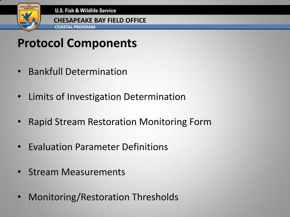
Protocol Components • Bankfull Determination
• Limits of Investigation Determination
• Rapid Stream Restoration Monitoring Form
• Evaluation Parameter Definitions • Stream Measurements
• Monitoring/Restoration Thresholds

CHESAPEAKE BAY FIELD OFFICE COASTAL PROGRAM
Bankfull Determination
• Review designer’s bankfull determination
• Review hydrology and hydraulics analysis
• Critical to evaluate stability and function
• Experience counts

CHESAPEAKE BAY FIELD OFFICE COASTAL PROGRAM
Investigation Limits
• Monitoring reach starts and ends where restoration has no visible influence
• Project limits may not matter

CHESAPEAKE BAY FIELD OFFICE COASTAL PROGRAM
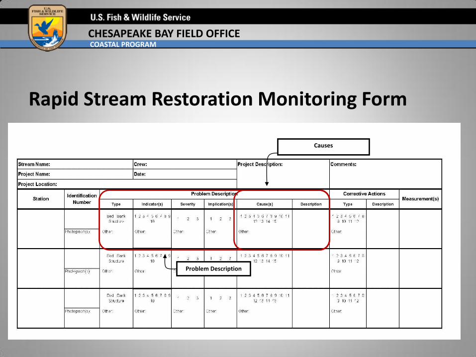
Rapid Stream Restoration Monitoring Form
Project Description
Station Identification Corrective Actions Problem Description
Measurements

CHESAPEAKE BAY FIELD OFFICE COASTAL PROGRAM
Rapid Stream Restoration Monitoring Form
Project Description
Station Identification Problem Description

CHESAPEAKE BAY FIELD OFFICE COASTAL PROGRAM
Rapid Stream Restoration Monitoring Form
Problem Description
Type/Indicators

CHESAPEAKE BAY FIELD OFFICE COASTAL PROGRAM
1 1 1
2 2 2
3 3 3
4 4 4
5 5 5
6 6 6
7 7 7
8 8 8
9 9 9
10 10 10
Bed Banks Structure
Pro
ble
m I
ncd
icato
r(s)
None (no problem indicators) None (no problem indicators) None (no problem indicators)
Degradation Increase in confinement Collapsed structure
Increase incision Increase in entrenchment Unstable/repositioned structure rocks
Scour Lateral scour/undercut Flow piping through structure
Increase in facet slopePlanform/radius of curvature
adjustments
Lack of adequeate pool depth/pool
formation
Poorly defined facet features Cutoff channel developmentAccelerated vertical scour/exposed
footer rocks
Decrease in facet slope Loss of bank vegetation
Accelerated lateral scour/scour
along deposition area at the
structure
Deposition/Bar Development Bank deposition Accelerated deposition in pool
Decrease incision Decrease in entrenchment Buried structure
Aggradation Decrease in confinement
Accelerated lateral scour
upstream/downstream of the
structure
Evaluation Attributes

CHESAPEAKE BAY FIELD OFFICE COASTAL PROGRAM
Rapid Stream Restoration Monitoring Form
Problem Description
Severity/Implications

CHESAPEAKE BAY FIELD OFFICE COASTAL PROGRAM
1 1 1
2 2 2
3 3 3
1 1 1
2 2 2
3 3 3
Bed Banks Structure
Severi
ty
Temporary scour or deposition formation
Localized bank erosion; minor loss of
bank material; BEHI and/or NBS have a
rating of low or less
Minor stress on the structure; still functioning as
intended
Limited scour or bar formation; minor
changes to bed characteristic
Moderate bank erosion; moderate loss
of bank material; BEHI and NBS have a
rating of moderate
Partial failure of structure; minimally functioning
as intended
Permanent scour or bar formation;
extensive changes to bed
characteristics
Failure of entire bank; bank actively
eroding and substantial loss of bank
material; BEHI and NBS have a rating of
high or greater
Complete structural failure; no longer functioning
as intended
Imp
licati
on
(s)
Not expected to worsen or cause further
problems; may stabilize over time
Not expected to worsen or cause further
problems; may stabilize over time
Not expected to w orsen or cause further
problems; may stabilize over time
Expected to worsen over time Expected to worsen over time Expected to w orsen over time
Immediate concern; will cause further
damage and contribute to other
problems
Immediated concern; will cause further
damage and contribute to other
problems
Immediated concern; w ill cause further damage
and contribute to other problems
Evaluation Attributes, continued
CHESAPEAKE BAY FIELD OFFICE COASTAL PROGRAM
Rapid Stream Restoration Monitoring Form
Problem Description
Causes

CHESAPEAKE BAY FIELD OFFICE COASTAL PROGRAM
1 1 1
2 2 2
3 3 3
4 4 4
5 5 5
6 6 6
7 7 7
8 8 8
9 9 9
10 10 10
11 11 11
12 12
13 13
14 14
15 15
Bed Banks Structure
Ap
pare
nt
Cau
se(s
)Localized sediment input from an
immediate source
Drainage feature (e.g., tributary or
outfall) entering streamIncorrect use of structure
Cross section width/depth ratio is
less than the design criteriaOverland/over bank drainage Improper installation
Cross section width/depth ratio is
larger than the design criteriaImproperly installed bank matting
Improper planform placement
(installation/implementation)
Excessive sediment input from
watershed sources upstream of the
project
Incorrect bank angle Improper design criteria
Aggradation from instream
vegetation, debris jam, or other
channel obstruction
Bank angle shallower than design
criteriaImproper channel dimension
Scour from debris jam or other
channel obstruction
Stucture not functioning properly
and leading to acelerated lateral
scour or deposition
Improper profile design
Unstable drainage feature (e.g.,
tributary or outfall) entering stream
Scour from debris jam or other
channel obstructionImproper planform design
Stucture not functioning properly
and leading to acelerated vertical
scour or deposition
Lack/loss of vegetation Improper material size
Channel incision; loss of floodplain
connectivityUnstable bank material/fill Change in flow regime
Improper channel dimensionChannel incision; loss of floodplain
connectivityExtreme flood or flow event
Improper profile design Improper channel dimension
Stucture not functioning properly
and leading to acelerated vertical
and/or lateral scour or deposition
Improper planform design Improper profile design
Improper bed material size Improper planform design
Change in flow regime Change in flow regime
Extreme flood or flow event Extreme flood or flow event
Evaluation Attributes, continued

CHESAPEAKE BAY FIELD OFFICE COASTAL PROGRAM
Rapid Stream Restoration Monitoring Form
Corrective Actions

CHESAPEAKE BAY FIELD OFFICE COASTAL PROGRAM
1 1 1
2 2 2
3 3 3
4 4 4
5 5 5
6 6 6
7 7 7
8 8 8
9 9 9
10 10
11
12
Bed Banks Structure
Co
rrecti
ve A
cti
on
(s)
No action No action No action
Remove debris jam, other
obstruction, and/or excessive
sediment
Armor bankRegrade banks, repair matting,
and/or replant vegetation
Armor bed to prevent scourRepair matting and/or replant
vegetationStabilize structure with rock material
Modify channel dimensions or
characteristics (e.g., active channel
bench); reconnect channel to
floodplain
Regrade banks, repair matting,
and/or replant vegetationRepair unstable portion of structure
Modify channel profileReinstall soil lifts and replant
vegetationRelocate or rebuild entire structure
Modify channel planformStabilize channel banks with rock
material
Modify channel dimensions or
characteristics (e.g., active channel
bench); reconnect channel to
floodplain
Construct grade control structure
Modify channel dimensions or
characteristics (e.g., active channel
bench); reconnect channel to
floodplain
Modify channel profile
Stabilize local sediment source Modify channel profile Modify channel planform
Manage stormwater quantity Modify channel planform Stabilize local sediment source
Construct grade control structure Manage stormwater quantity
Stabilize local sediment source
Manage stormwater quantity
Evaluation Attributes, continued

CHESAPEAKE BAY FIELD OFFICE COASTAL PROGRAM
Rapid Stream Restoration Monitoring Form
Measurements
Common Measurements •Bankfull Width •Bankfull Depth •Width/Depth Ratio •Active Channel Width •Meander Width Ratio •Slope •Many More

CHESAPEAKE BAY FIELD OFFICE COASTAL PROGRAM
Protocol Components • Bankfull Determination
• Limits of Investigation Determination
• Rapid Stream Restoration Monitoring Form
• Evaluation Parameter Definitions • Stream Measurements • Monitoring/Restoration Thresholds

CHESAPEAKE BAY FIELD OFFICE COASTAL PROGRAM
Second Tier – Used for localized impacts that may be significant threats to
the restoration function – Requires monumented monitoring to determine instability
trends – Will determine if remediation (third tier) is required
Third Tier – Used for widespread impacts that pose a significant threat
to restoration function – Used when repair or remediation is required – May include restoration design and implementation

CHESAPEAKE BAY FIELD OFFICE COASTAL PROGRAM
Summary • Develop a rapid and standardized method to evaluate the stability and
functional success of a restored stream
• Establish a minimum standard necessary to evaluate the stability and functional success of a restored stream
• Promote consistent and reproducible results
• Identify situations that require additional monitoring
• Identify potential causes for impairment
• Identify potential corrective actions

CHESAPEAKE BAY FIELD OFFICE COASTAL PROGRAM
Future Direction
• Adjust methodology to incorporate functional description