Embed Size (px)
Citation preview
Coastal Flood Insurance Studies in Virginia and Climate Change
US Army Engineer Research and Development Center
VFMA Floodplain Management WorkshopOctober 22, 2015
Jeff Gangai
2US Army Engineer Research and Development Center
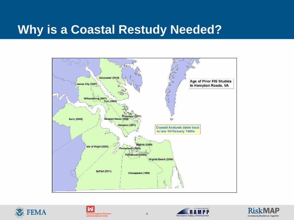
Why is a Coastal Restudy Needed?
New Guidelines need to be implemented Atlantic Ocean and Gulf of Mexico Guidelines Update (2007) Sheltered Waters Report (2008) PM 50 Limit of Moderate Wave Action (LiMWA) (2008) and new 2013
OG
To update base data such as topographic dataset and aerial imagery to high resolution products and seamless Digital Elevation Model (DEM)
To utilize newer coastal hazard methodologies developed during the FEMA Mississippi Coastal Restudy
To take advantage of higher performance numerical modeling
To take advantage of improvement in GIS technologies to allow for more precise FIRMs
3US Army Engineer Research and Development Center
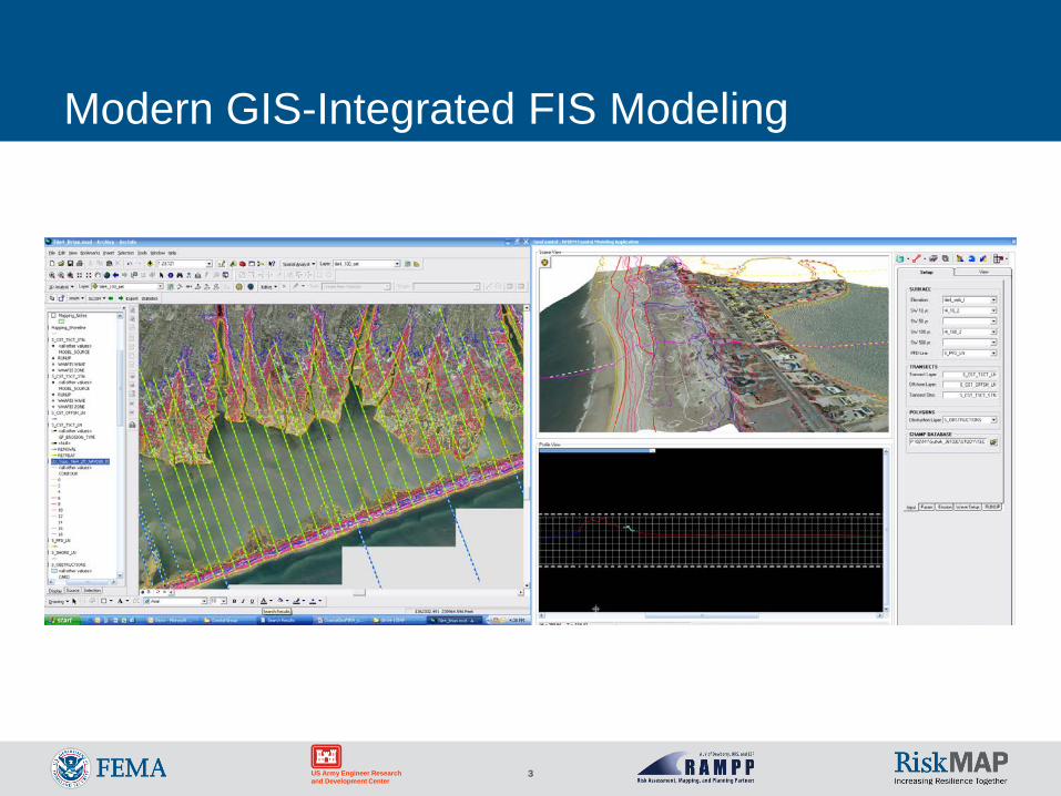
Modern GIS-Integrated FIS Modeling
4US Army Engineer Research and Development Center
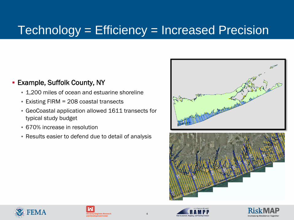
Technology = Efficiency = Increased Precision
Example, Suffolk County, NY• 1,200 miles of ocean and estuarine shoreline• Existing FIRM = 208 coastal transects• GeoCoastal application allowed 1611 transects for
typical study budget• 670% increase in resolution• Results easier to defend due to detail of analysis
5US Army Engineer Research and Development Center
Map Modernization
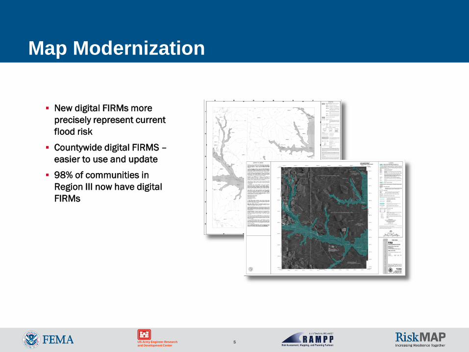
New digital FIRMs more precisely represent current flood risk
Countywide digital FIRMS –easier to use and update
98% of communities in Region III now have digital FIRMs
6US Army Engineer Research and Development Center
Why is a Coastal Restudy Needed?
7US Army Engineer Research and Development Center
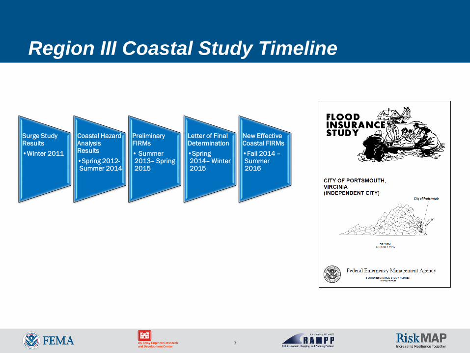
Region III Coastal Study Timeline
Surge Study Results•Winter 2011
Coastal Hazard Analysis Results•Spring 2012-Summer 2014
Preliminary FIRMs• Summer 2013– Spring 2015
Letter of Final Determination•Spring 2014– Winter 2015
New Effective Coastal FIRMs•Fall 2014 –Summer 2016
8US Army Engineer Research and Development Center
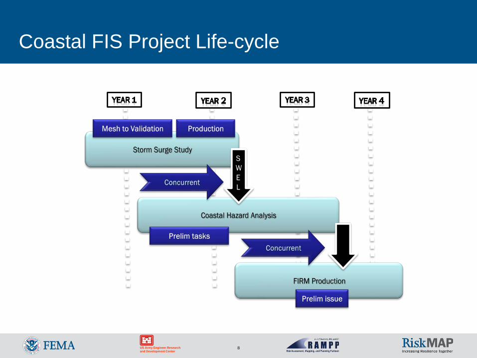
Coastal FIS Project Life-cycle
9US Army Engineer Research and Development Center
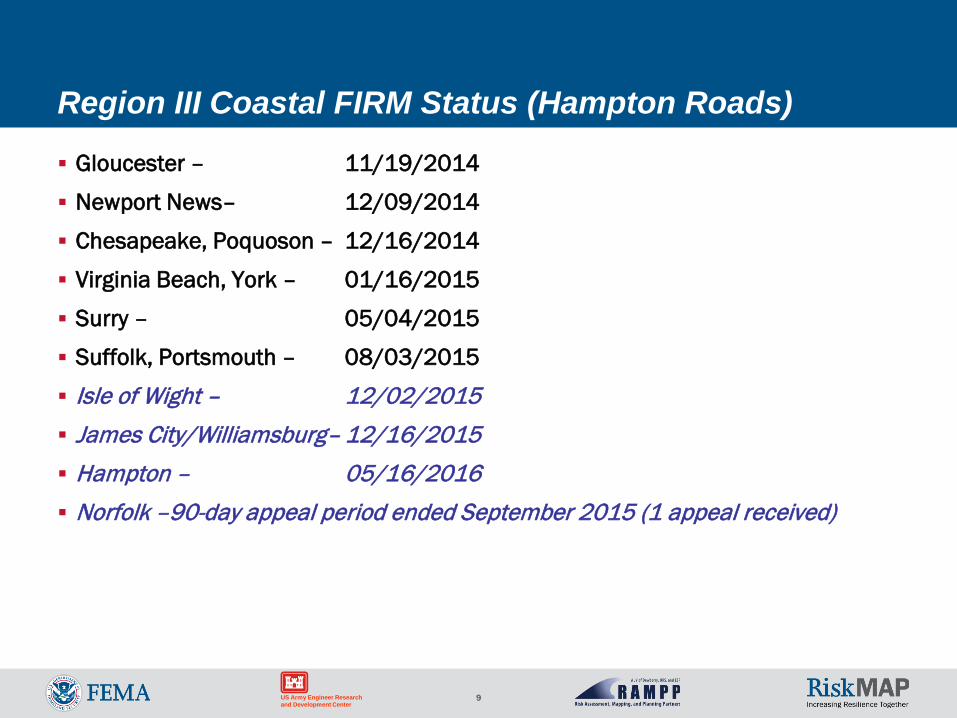
Region III Coastal FIRM Status (Hampton Roads)
Gloucester – 11/19/2014
Newport News– 12/09/2014
Chesapeake, Poquoson – 12/16/2014
Virginia Beach, York – 01/16/2015
Surry – 05/04/2015
Suffolk, Portsmouth – 08/03/2015
Isle of Wight – 12/02/2015 James City/Williamsburg– 12/16/2015 Hampton – 05/16/2016 Norfolk –90-day appeal period ended September 2015 (1 appeal received)
10
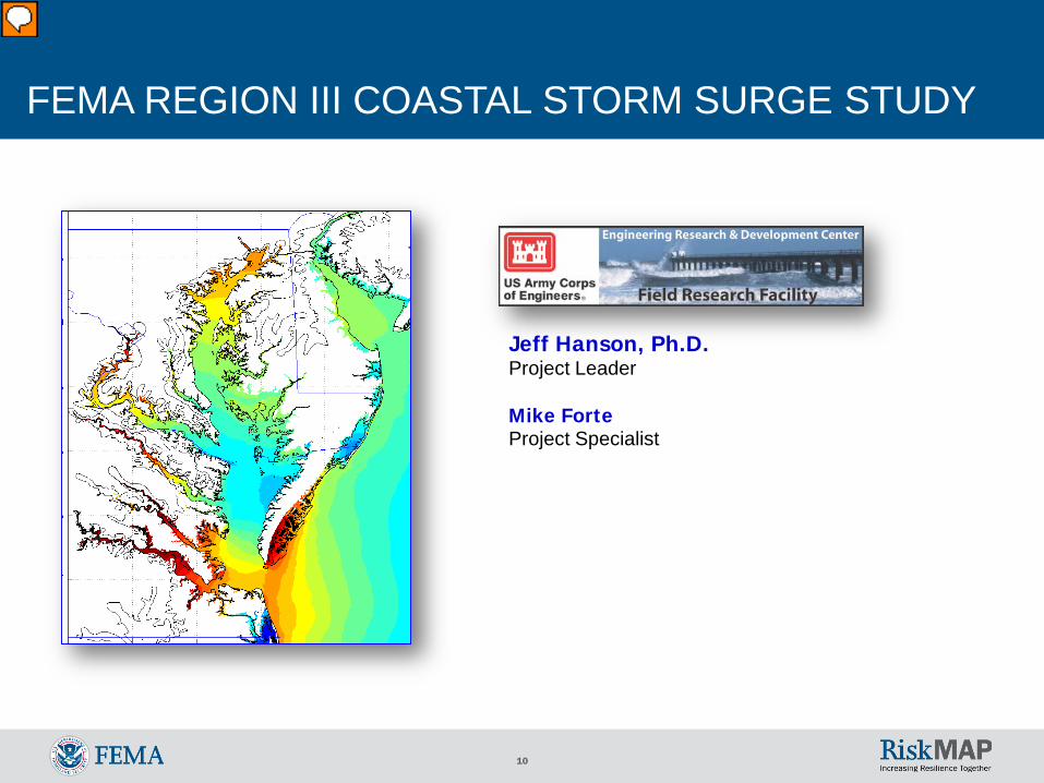
FEMA REGION III COASTAL STORM SURGE STUDY
Jeff Hanson, Ph.D.Project Leader
Mike ForteProject Specialist
11US Army Engineer Research and Development Center
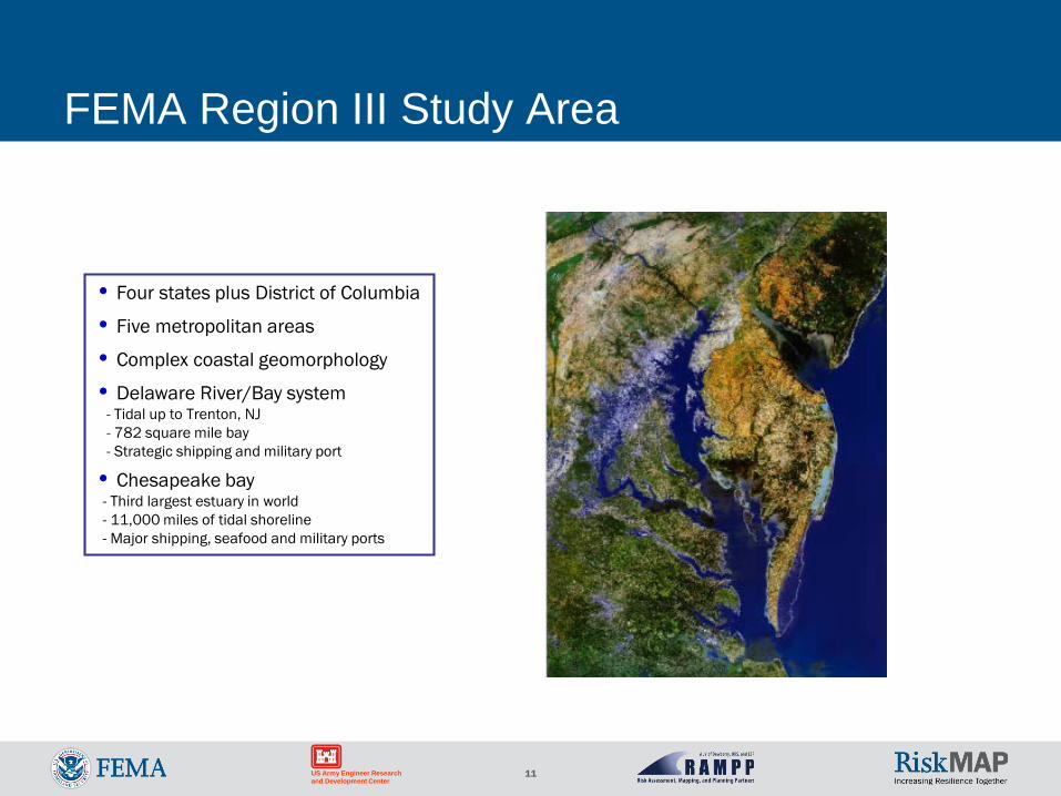
FEMA Region III Study Area
• Four states plus District of Columbia
• Five metropolitan areas
• Complex coastal geomorphology
• Delaware River/Bay system- Tidal up to Trenton, NJ- 782 square mile bay- Strategic shipping and military port
• Chesapeake bay - Third largest estuary in world- 11,000 miles of tidal shoreline- Major shipping, seafood and military ports
12US Army Engineer Research and Development Center
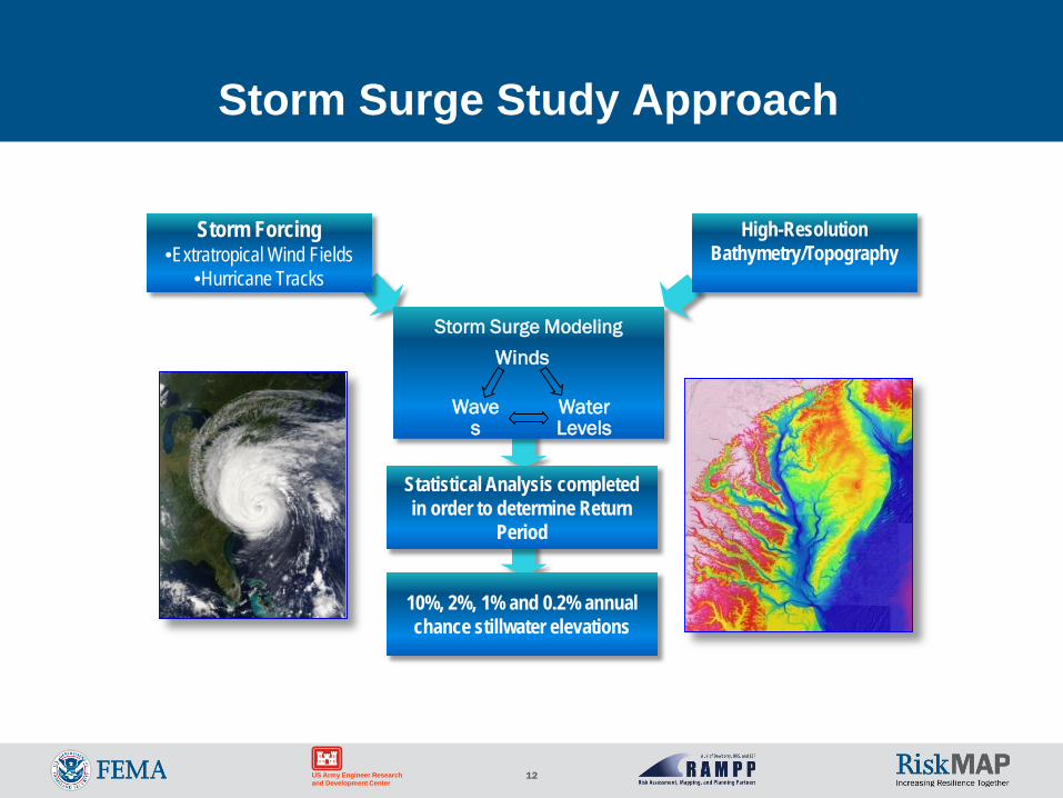
Storm Surge Study Approach
Storm Surge Modeling
Statistical Analysis completed in order to determine Return
Period
Storm Forcing•Extratropical Wind Fields
•Hurricane Tracks
High-Resolution Bathymetry/Topography
Winds
Water Levels
Waves
10%, 2%, 1% and 0.2% annual chance stillwater elevations
13US Army Engineer Research and Development Center
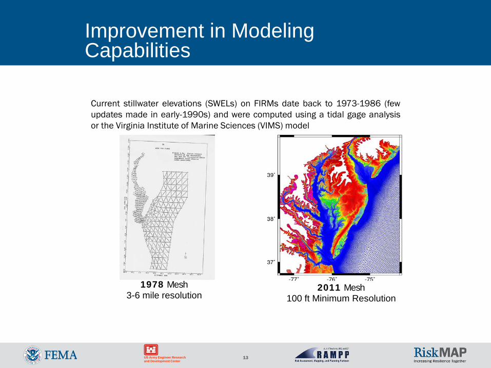
Improvement in Modeling Capabilities
1978 Mesh3-6 mile resolution
2011 Mesh100 ft Minimum Resolution
Current stillwater elevations (SWELs) on FIRMs date back to 1973-1986 (fewupdates made in early-1990s) and were computed using a tidal gage analysisor the Virginia Institute of Marine Sciences (VIMS) model
14US Army Engineer Research and Development Center
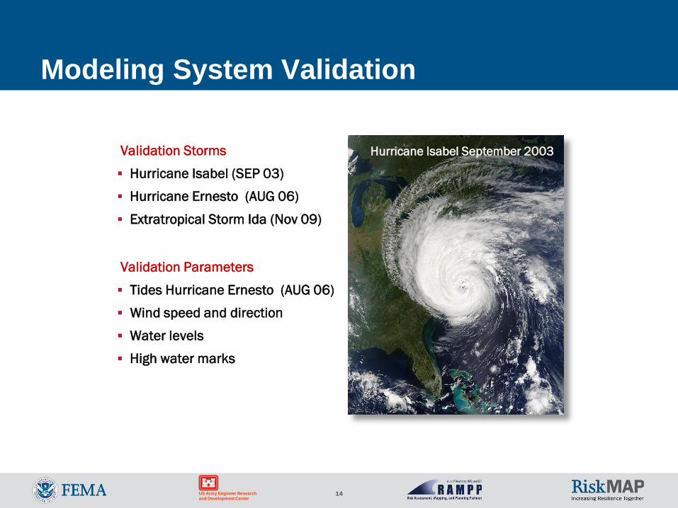
Modeling System Validation
Validation Storms
Hurricane Isabel (SEP 03)
Hurricane Ernesto (AUG 06)
Extratropical Storm Ida (Nov 09)
Validation Parameters
Tides Hurricane Ernesto (AUG 06)
Wind speed and direction
Water levels
High water marks
Hurricane Isabel September 2003
15US Army Engineer Research and Development Center
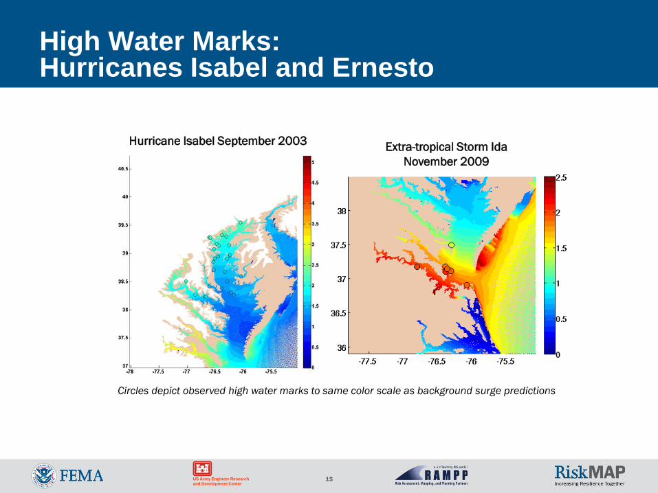
High Water Marks: Hurricanes Isabel and Ernesto
Hurricane Isabel September 2003 Extra-tropical Storm Ida November 2009
Circles depict observed high water marks to same color scale as background surge predictions
16US Army Engineer Research and Development Center
Production Run Storms
Extratropical Storms
• 30 Top ranked storms 1975-2009
• Based on water levels at 10 stations
• Careful reanalysis of wind/pressure fields
February 4, 1998 Pressure Field
Tropical Storms
• Record of 20 hurricanes in 60 years insufficient for 100- yr analysis
• 156 Representative events sampled from ASCE 100,000-year synthetic storm set
• A 1-year effort!
• Intensities range from Tropical Storm to Cat 3
• Demonstrated validity with comparisons to historic data
156 Simulated Hurricane
Tracks
17
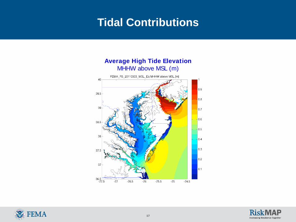
Tidal Contributions
Average High Tide ElevationMHHW above MSL (m)
18US Army Engineer Research and Development Center
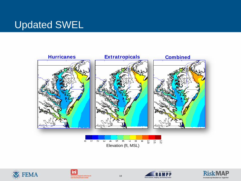
Updated SWEL
Hurricanes Extratropicals Combined
Elevation (ft, MSL)
19
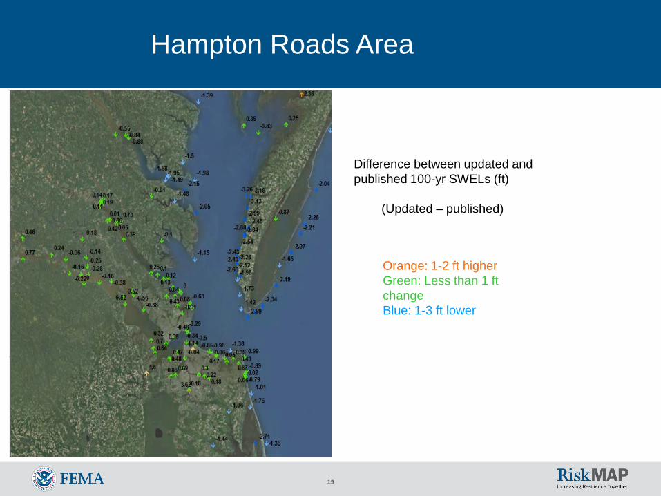
Difference between updated and published 100-yr SWELs (ft)
(Updated – published)
Orange: 1-2 ft higherGreen: Less than 1 ft changeBlue: 1-3 ft lower
Hampton Roads Area
20US Army Engineer Research and Development Center
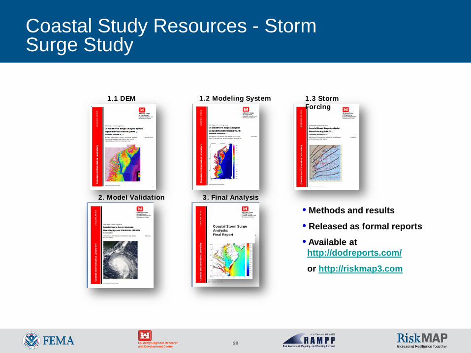
Coastal Study Resources - Storm Surge Study
1.1 DEM
Coastal Storm Surge Analysis:Final Report
1.2 Modeling System 1.3 Storm Forcing
3. Final Analysis2. Model Validation
• Methods and results
• Released as formal reports
• Available at http://dodreports.com/
or http://riskmap3.com
21US Army Engineer Research and Development Center
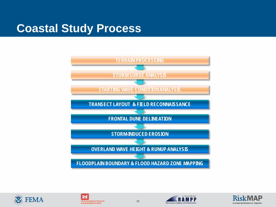
Coastal Study Process
FLOODPLAIN BOUNDARY & FLOOD HAZARD ZONE MAPPING
OVERLAND WAVE HEIGHT & RUNUP ANALYSIS
STORM-INDUCED EROSION
FRONTAL DUNE DELINEATION
TRANSECT LAYOUT & FIELD RECONNAISSANCE
STARTING WAVE CONDITION ANALYSIS
STORM SURGE ANALYSIS
TERRAIN PROCESSING
22US Army Engineer Research and Development Center
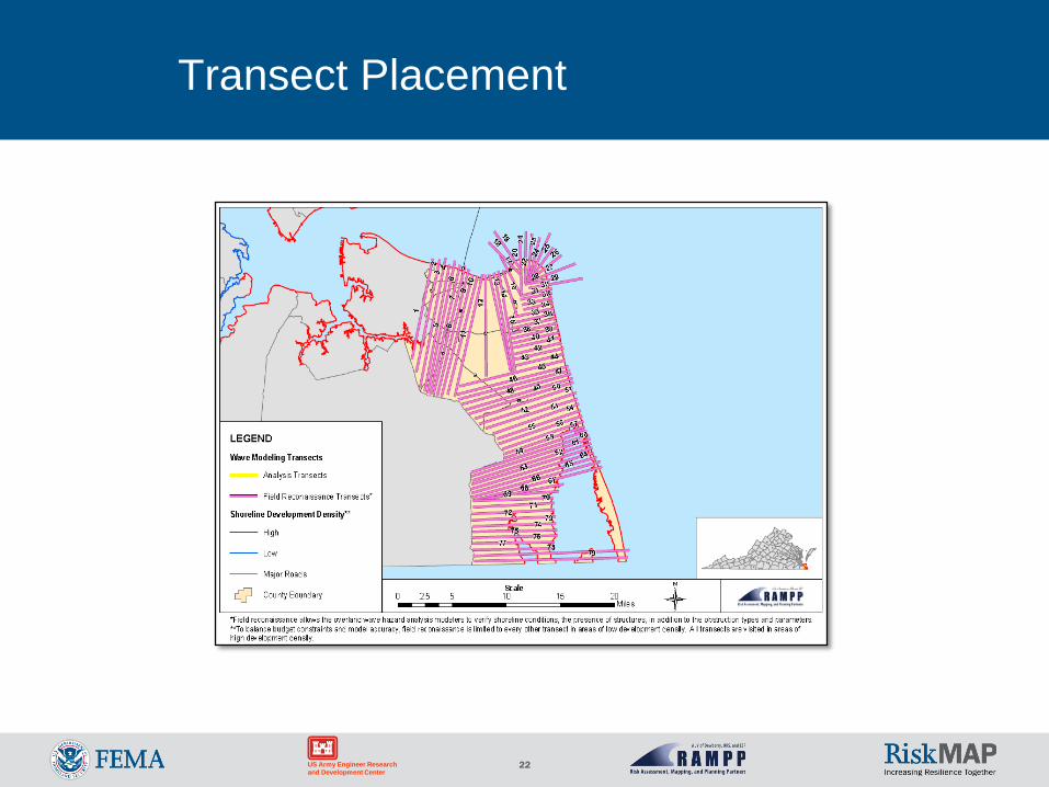
Transect Placement
Transect LayoutCity of Virginia Beach
23US Army Engineer Research and Development Center
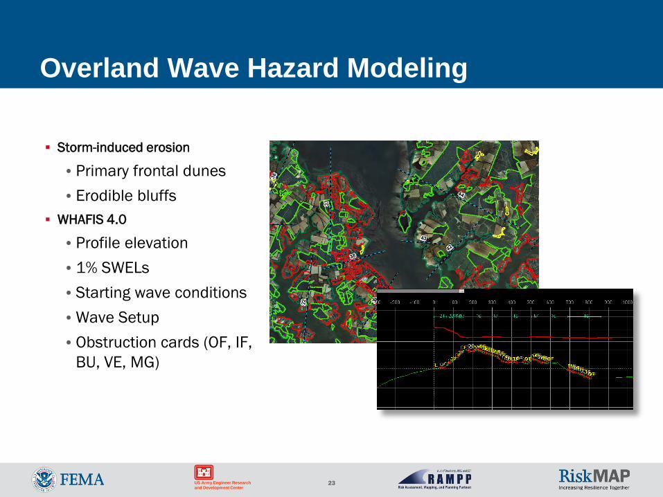
Overland Wave Hazard Modeling
Storm-induced erosion
•Primary frontal dunes•Erodible bluffs
WHAFIS 4.0
•Profile elevation•1% SWELs•Starting wave conditions•Wave Setup •Obstruction cards (OF, IF,
BU, VE, MG)
24US Army Engineer Research and Development Center
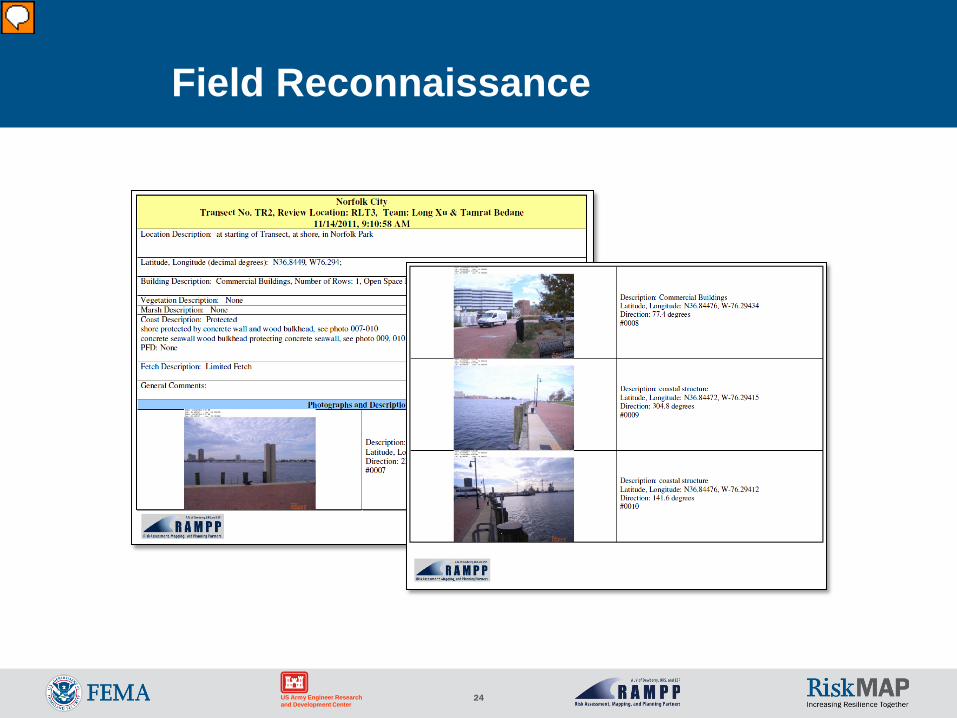
Field Reconnaissance
25US Army Engineer Research and Development Center
DRAFT
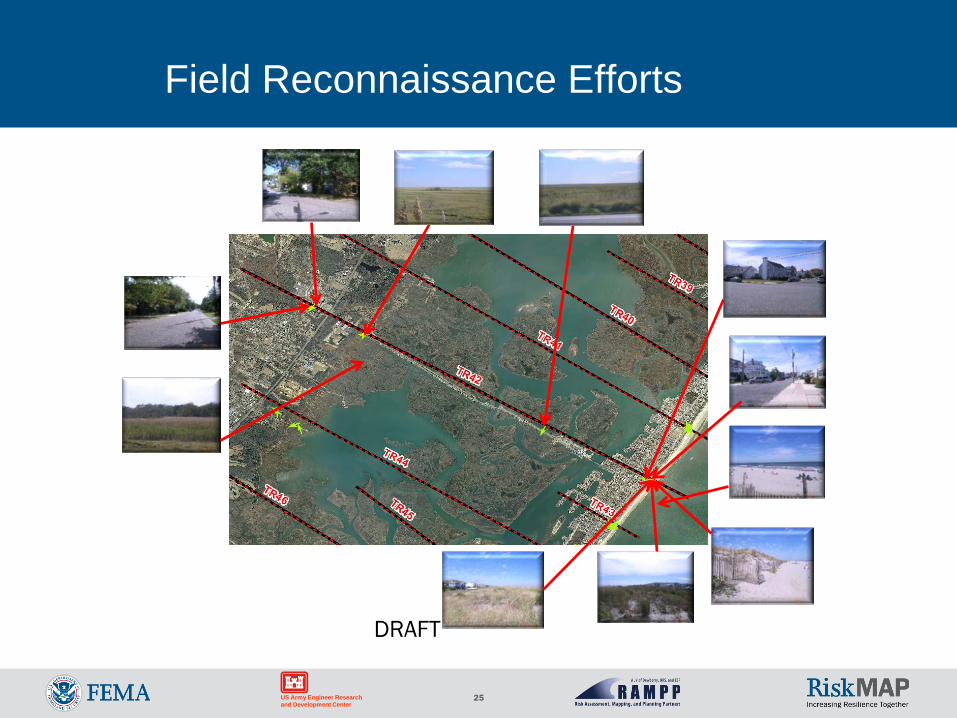
Field Reconnaissance Efforts
26US Army Engineer Research and Development Center
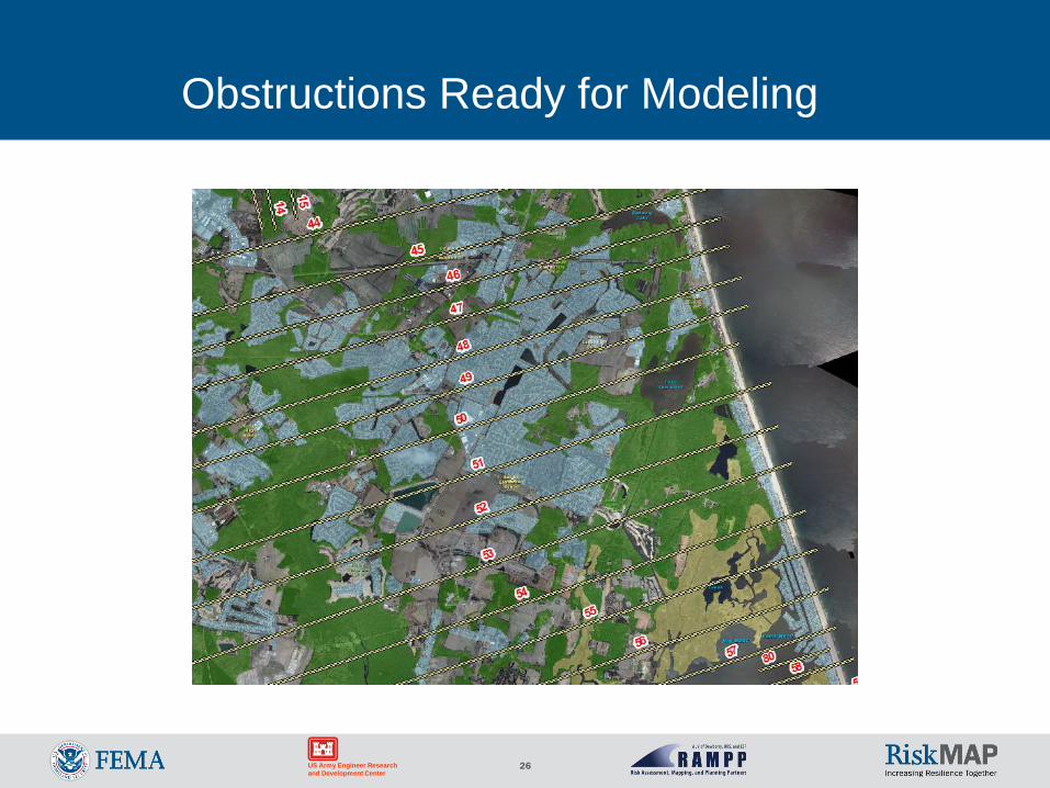
Obstructions Ready for Modeling
27US Army Engineer Research and Development Center
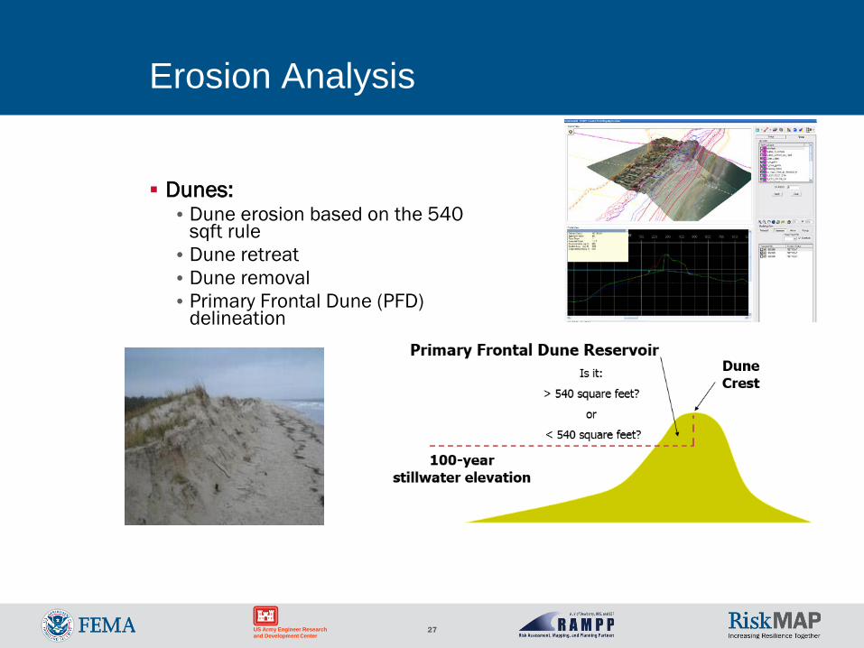
Erosion Analysis
Dunes:•Dune erosion based on the 540
sqft rule•Dune retreat•Dune removal• Primary Frontal Dune (PFD)
delineation
28US Army Engineer Research and Development Center
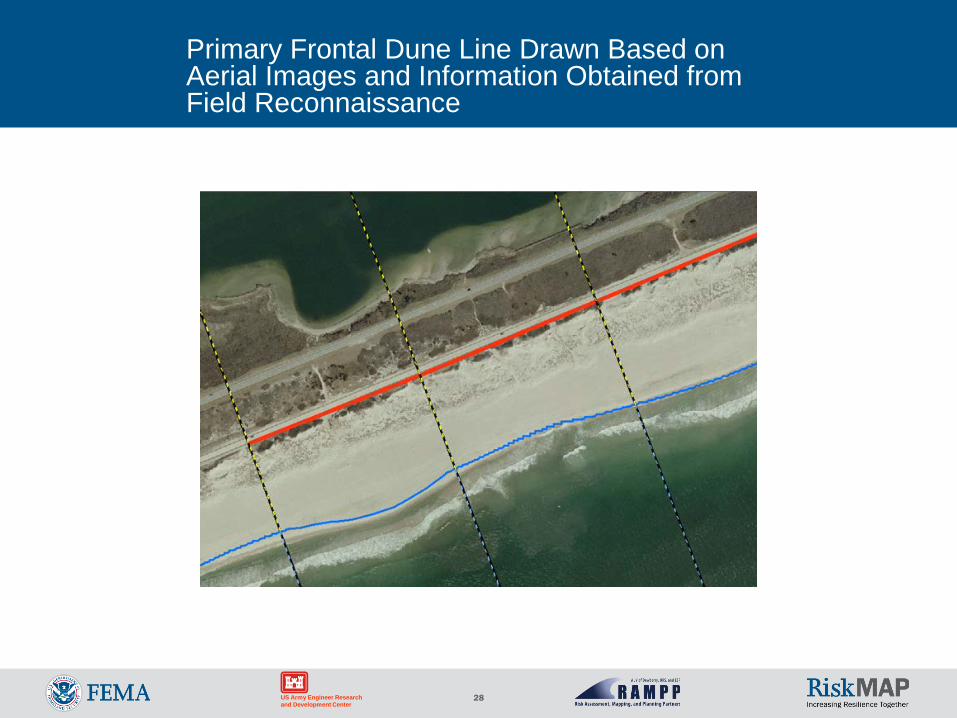
Primary Frontal Dune Line Drawn Based on Aerial Images and Information Obtained from Field Reconnaissance
29US Army Engineer Research and Development Center
Shoreline Protection andWave Runup
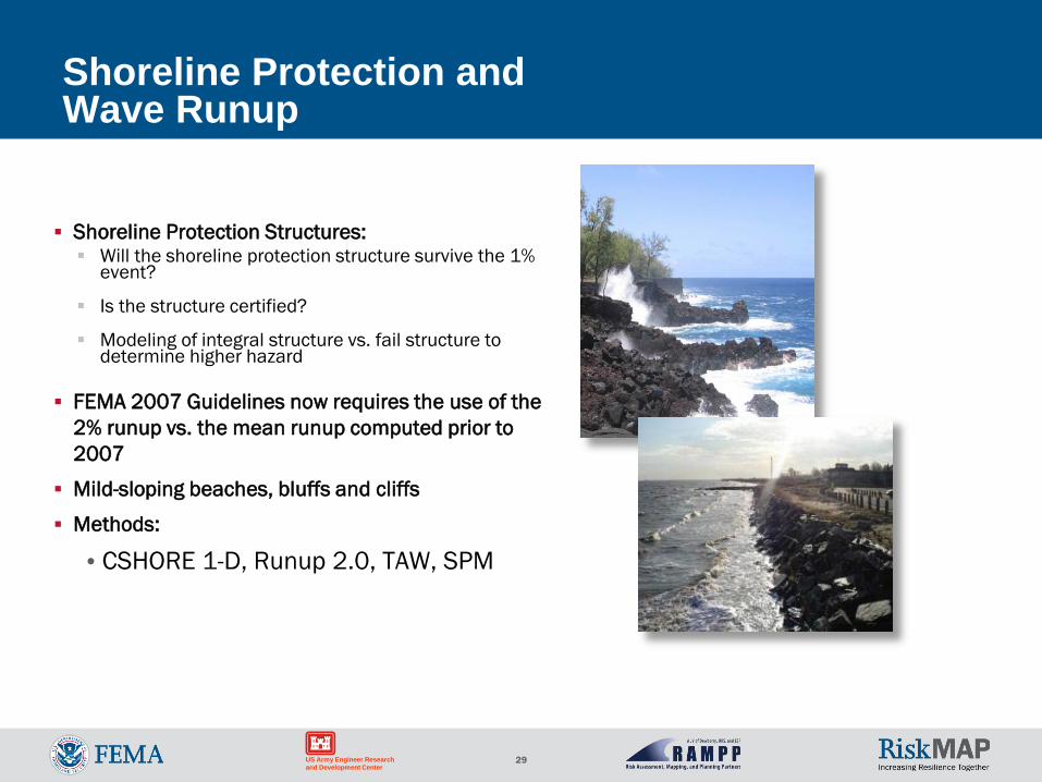
Shoreline Protection Structures: Will the shoreline protection structure survive the 1%
event?
Is the structure certified?
Modeling of integral structure vs. fail structure to determine higher hazard
FEMA 2007 Guidelines now requires the use of the 2% runup vs. the mean runup computed prior to 2007
Mild-sloping beaches, bluffs and cliffs
Methods:
•CSHORE 1-D, Runup 2.0, TAW, SPM
30US Army Engineer Research and Development Center
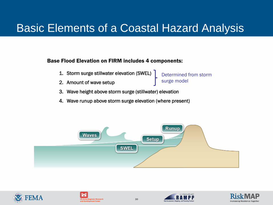
Basic Elements of a Coastal Hazard Analysis
Base Flood Elevation on FIRM includes 4 components:
1. Storm surge stillwater elevation (SWEL)
2. Amount of wave setup
3. Wave height above storm surge (stillwater) elevation
4. Wave runup above storm surge elevation (where present)
Determined from storm surge model
31US Army Engineer Research and Development Center
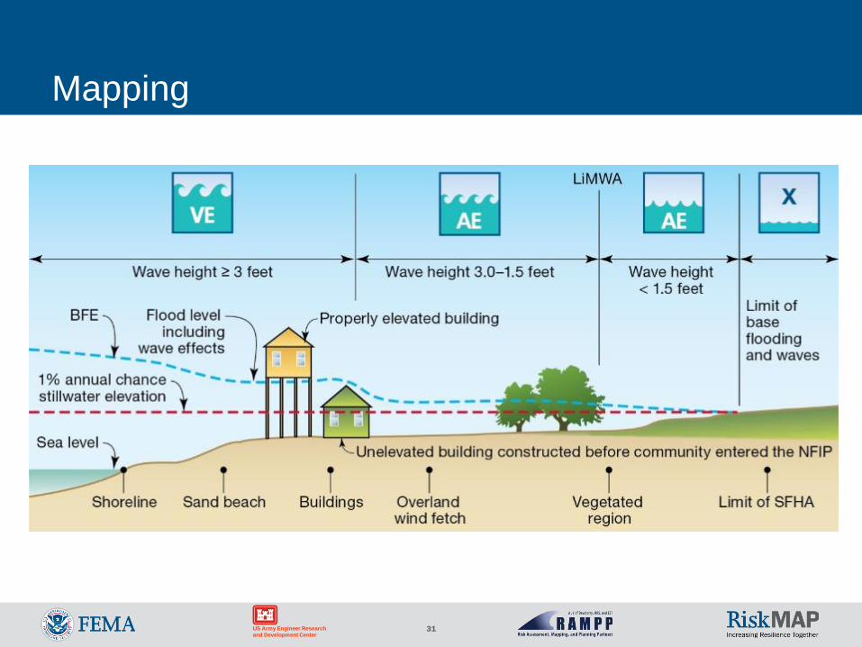
Mapping
32US Army Engineer Research and Development Center
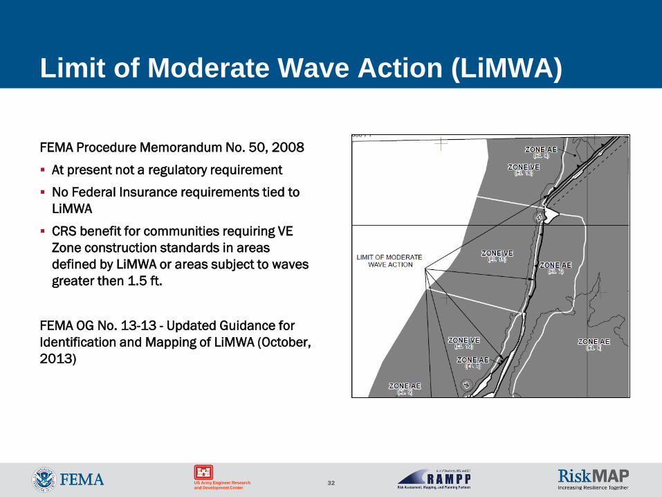
Limit of Moderate Wave Action (LiMWA)
FEMA Procedure Memorandum No. 50, 2008
At present not a regulatory requirement
No Federal Insurance requirements tied to LiMWA
CRS benefit for communities requiring VE Zone construction standards in areas defined by LiMWA or areas subject to waves greater then 1.5 ft.
FEMA OG No. 13-13 - Updated Guidance for Identification and Mapping of LiMWA (October, 2013)
33US Army Engineer Research and Development Center
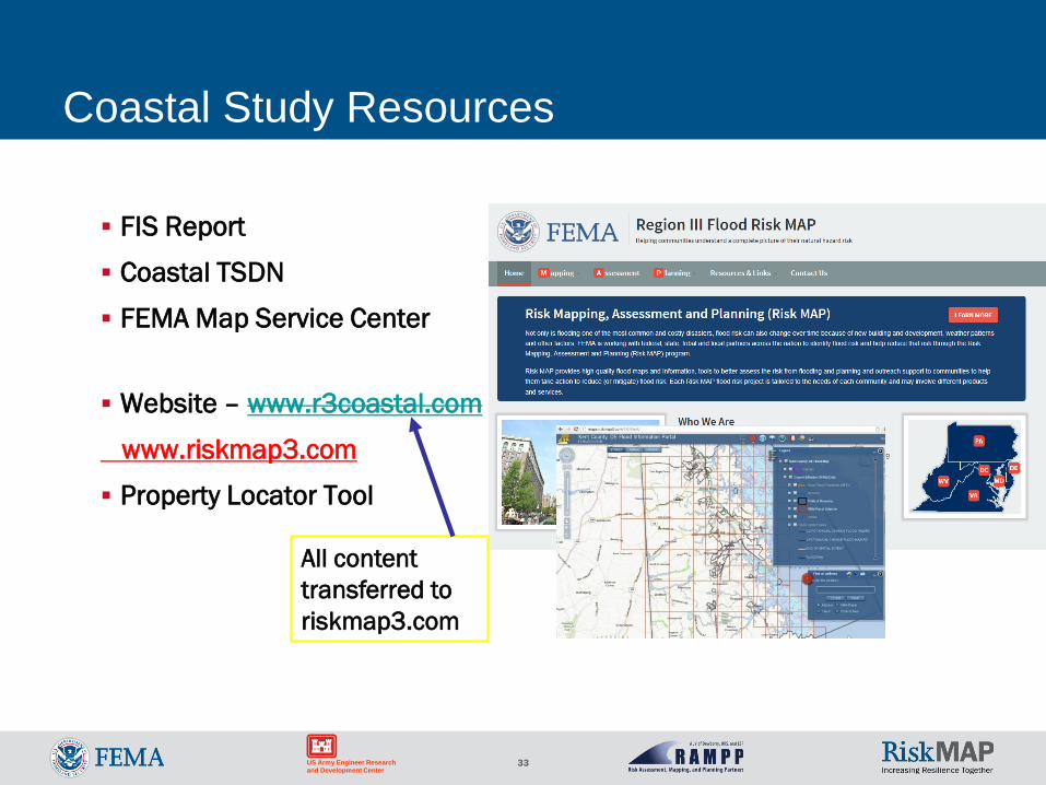
Coastal Study Resources
FIS Report
Coastal TSDN
FEMA Map Service Center
Website – www.r3coastal.com
www.riskmap3.com
Property Locator Tool
All content transferred to riskmap3.com
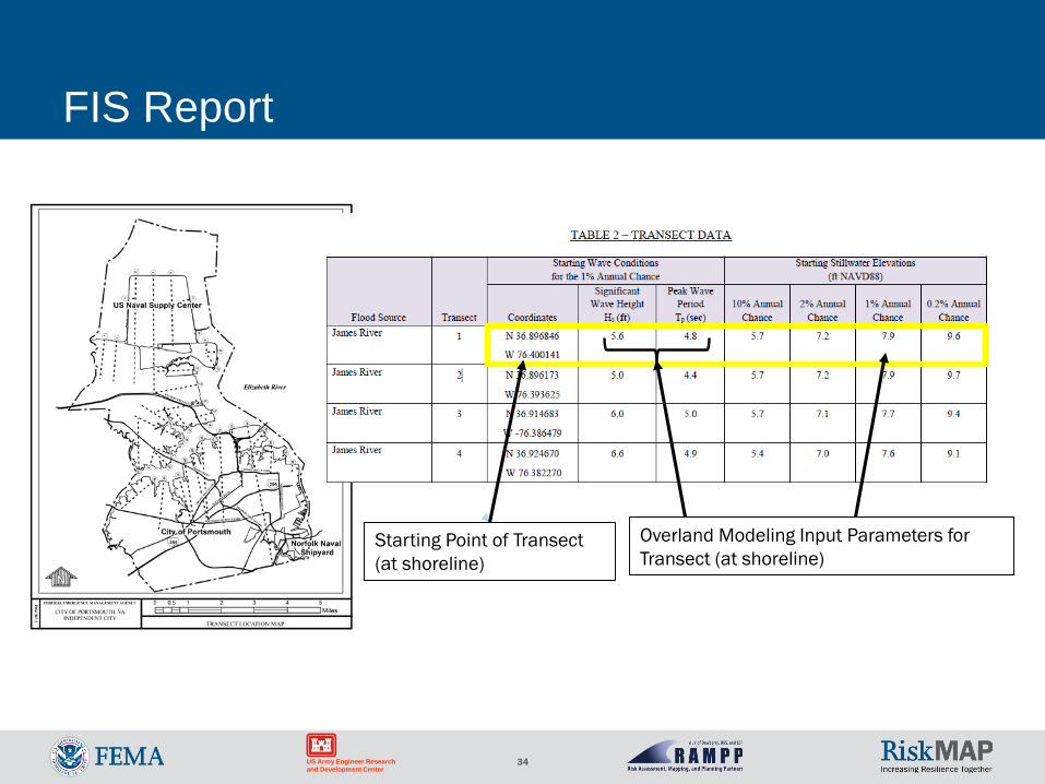
34US Army Engineer Research and Development Center
FIS Report
Starting Point of Transect (at shoreline)
Overland Modeling Input Parameters for Transect (at shoreline)
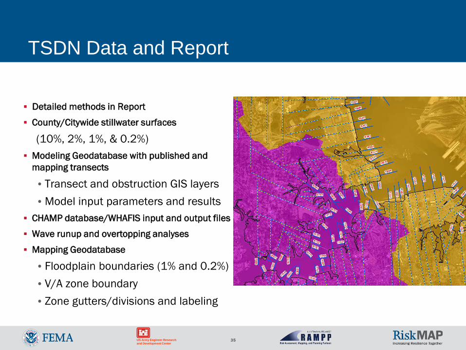
35US Army Engineer Research and Development Center
TSDN Data and Report
Detailed methods in Report
County/Citywide stillwater surfaces
(10%, 2%, 1%, & 0.2%) Modeling Geodatabase with published and
mapping transects
•Transect and obstruction GIS layers•Model input parameters and results
CHAMP database/WHAFIS input and output files
Wave runup and overtopping analyses
Mapping Geodatabase
•Floodplain boundaries (1% and 0.2%)•V/A zone boundary•Zone gutters/divisions and labeling
36US Army Engineer Research and Development Center
Potential for Ongoing and Future Work
SLR studies
Assessment of flood protection strategies• Design parameters for shoreline protection
structures• Suitability of living shorelines
Boundary conditions for refined regional or local coastal models
Establishment of tailwater conditions for stormwater models
Floodplain mapping changes for Flood Mitigation Efforts (CLOMR and LOMR)
37US Army Engineer Research and Development Center
Future Updates to Studies
Coastal Coordinated Needs Management System (CNMS)•Every 5 year evaluate validity of Coastal Study and Mapping on FIRMs Elevation & Bathymetry Data Land Use Modeling Technology Guidelines and Methods Historic Storms Damage Storm Frequency Shoreline Position (Long-term erosion) Water levels (sea level rise/lake level)
38US Army Engineer Research and Development Center
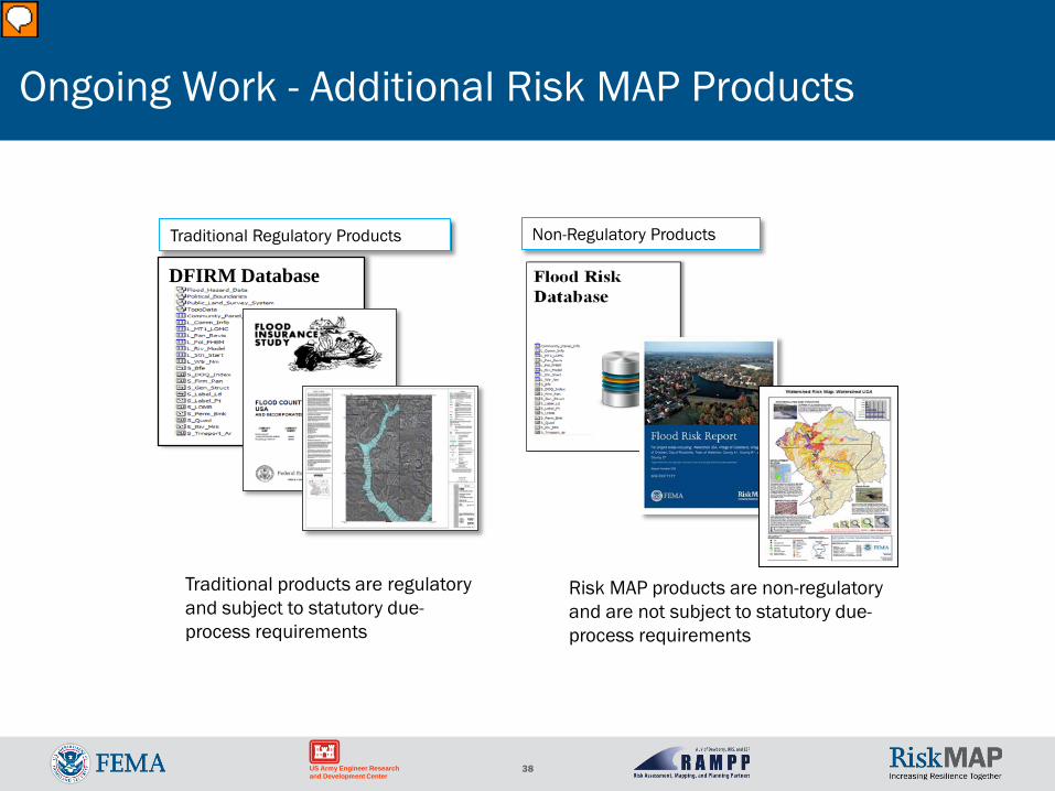
Traditional products are regulatory and subject to statutory due-process requirements
Risk MAP products are non-regulatory and are not subject to statutory due-process requirements
Ongoing Work - Additional Risk MAP Products
DFIRM Database
Traditional Regulatory Products Non-Regulatory Products
39US Army Engineer Research and Development Center
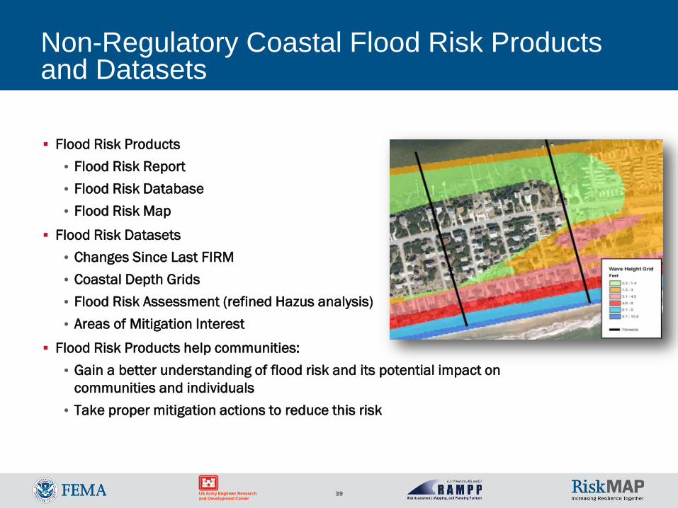
Non-Regulatory Coastal Flood Risk Products and Datasets
Flood Risk Products • Flood Risk Report• Flood Risk Database • Flood Risk Map
Flood Risk Datasets• Changes Since Last FIRM • Coastal Depth Grids• Flood Risk Assessment (refined Hazus analysis)• Areas of Mitigation Interest
Flood Risk Products help communities:• Gain a better understanding of flood risk and its potential impact on
communities and individuals • Take proper mitigation actions to reduce this risk
40US Army Engineer Research and Development Center
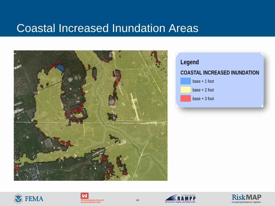
Coastal Increased Inundation Areas
LegendCOASTAL INCREASED INUNDATION
base + 1 foot
base + 2 foot
base + 3 foot
41
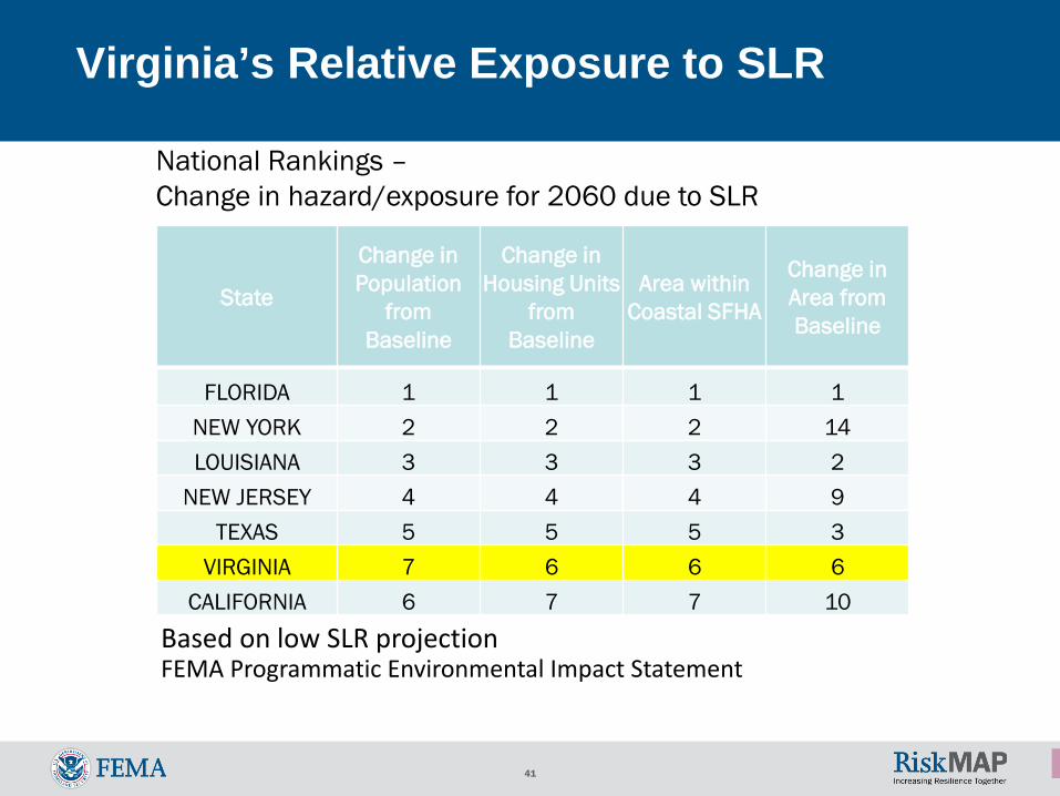
State
Change inPopulation
from Baseline
Change inHousing Units
from Baseline
Area withinCoastal SFHA
Change inArea fromBaseline
FLORIDA 1 1 1 1 NEW YORK 2 2 2 14 LOUISIANA 3 3 3 2
NEW JERSEY 4 4 4 9 TEXAS 5 5 5 3
VIRGINIA 7 6 6 6 CALIFORNIA 6 7 7 10
Virginia’s Relative Exposure to SLR
Based on low SLR projectionFEMA Programmatic Environmental Impact Statement
National Rankings –Change in hazard/exposure for 2060 due to SLR
42US Army Engineer Research and Development Center
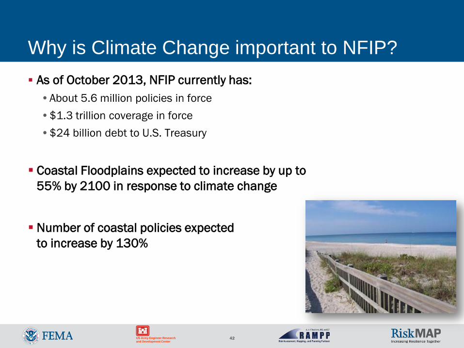
Why is Climate Change important to NFIP? As of October 2013, NFIP currently has:•About 5.6 million policies in force•$1.3 trillion coverage in force•$24 billion debt to U.S. Treasury
Coastal Floodplains expected to increase by up to 55% by 2100 in response to climate change
Number of coastal policies expected to increase by 130%
43US Army Engineer Research and Development Center
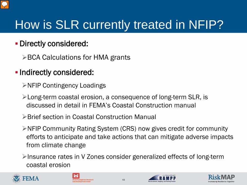
How is SLR currently treated in NFIP?Directly considered:
BCA Calculations for HMA grants
Indirectly considered:NFIP Contingency Loadings
Long-term coastal erosion, a consequence of long-term SLR, is discussed in detail in FEMA’s Coastal Construction manual
Brief section in Coastal Construction Manual
NFIP Community Rating System (CRS) now gives credit for community efforts to anticipate and take actions that can mitigate adverse impacts from climate change
Insurance rates in V Zones consider generalized effects of long-term coastal erosion
44US Army Engineer Research and Development Center
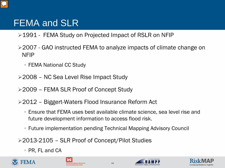
FEMA and SLR1991 - FEMA Study on Projected Impact of RSLR on NFIP
2007 - GAO instructed FEMA to analyze impacts of climate change on NFIP FEMA National CC Study
2008 – NC Sea Level Rise Impact Study
2009 – FEMA SLR Proof of Concept Study
2012 – Biggert-Waters Flood Insurance Reform Act Ensure that FEMA uses best available climate science, sea level rise and
future development information to access flood risk.
Future implementation pending Technical Mapping Advisory Council
2013-2105 – SLR Proof of Concept/Pilot Studies PR, FL and CA
45US Army Engineer Research and Development Center
Biggert-Waters Flood Insurance Reform Act of 2012
Section 100216: •Authorizes FEMA to include sea level rise information in FIRM updates•Inclusion of this information on FIRMs will be done in coordination with a Technical
Mapping Advisory Council established in Section 100215
Section 100215: •Establishes TMAC (Technical Mapping Advisory Council)•TMAC will be comprised of members from Federal, State, Local governments, as
well as representatives from various Organizations and Associations•TMAC will be charged in part in developing recommendations to FEMA on how to
incorporate Climate Change data and information into the NFIP
46US Army Engineer Research and Development Center
SLR Advisory Layer Concept
Non-regulatory (advisory)
Low incremental production cost
Develop as add-on to Risk MAP studies •Leverage models/data produced by FIS
Convey future changes to coastal flood hazard
Guide long-term planning & adaptation
Develop for pro-active states & communities
47US Army Engineer Research and Development Center
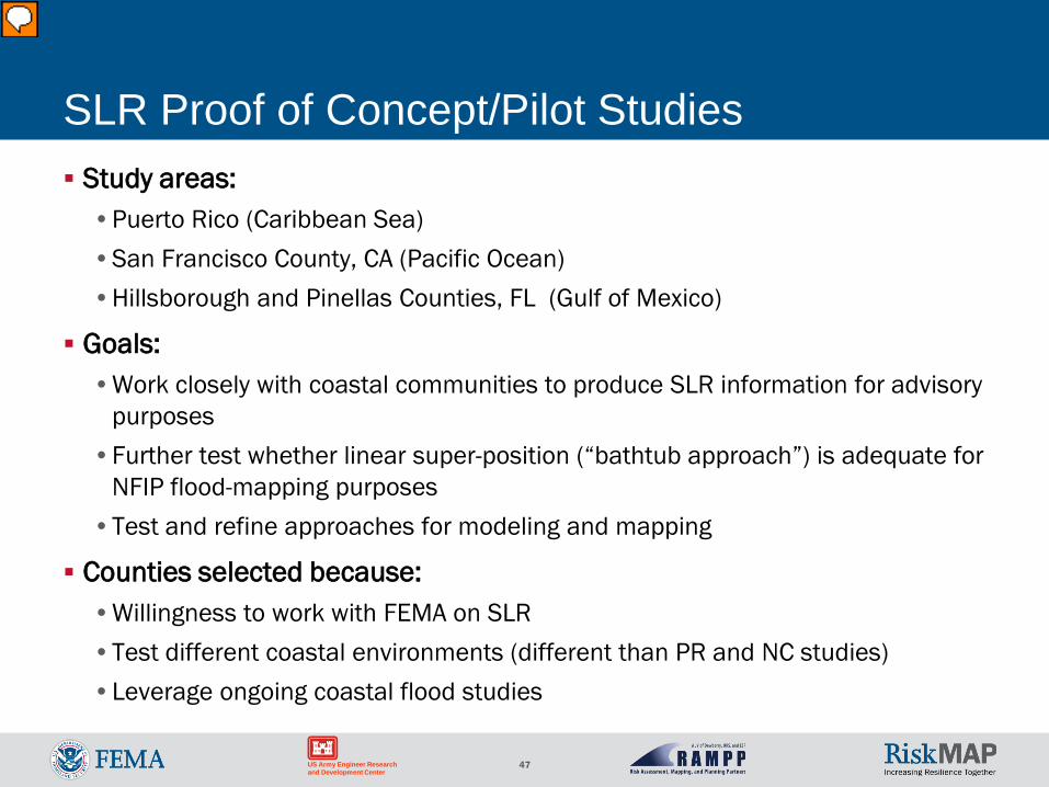
SLR Proof of Concept/Pilot Studies Study areas:•Puerto Rico (Caribbean Sea)•San Francisco County, CA (Pacific Ocean)•Hillsborough and Pinellas Counties, FL (Gulf of Mexico)
Goals:•Work closely with coastal communities to produce SLR information for advisory
purposes•Further test whether linear super-position (“bathtub approach”) is adequate for
NFIP flood-mapping purposes•Test and refine approaches for modeling and mapping
Counties selected because:•Willingness to work with FEMA on SLR•Test different coastal environments (different than PR and NC studies) •Leverage ongoing coastal flood studies
48US Army Engineer Research and Development Center
Questions? Dewberry
• Jeff Gangai, [email protected]
FEMA• Robert Pierson


![Coastal and Delta Flood Management [v1.0] [130525]...COASTAL AND DELTA FLOOD MANAGEMENT [V1.0] [130525] PREFACE Coastal flood hazards are diverse (storm surges, tsunamis, tropical](https://img.pdfslide.us/doc/110x75/6104341836607b292d10e810/coastal-and-delta-flood-management-v10-130525-coastal-and-delta-flood-management.jpg)