Embed Size (px)
Citation preview

Coastal Erosion in New South Wales Statewide Exposure Assessment

© 2017 State of NSW and Office of Environment and Heritage
With the exception of photographs, the State of NSW and Office of Environment and Heritage are pleased to allow this material to be reproduced in whole or in part for educational and non-commercial use, provided the meaning is unchanged and its source, publisher and authorship are acknowledged. Specific permission is required for the reproduction of photographs.
The Office of Environment and Heritage (OEH) has compiled this report in good faith, exercising all due care and attention. No representation is made about the accuracy, completeness or suitability of the information in this publication for any particular purpose. OEH shall not be liable for any damage which may occur to any person or organisation taking action or not on the basis of this publication. Readers should seek appropriate advice when applying the information to their specific needs.
All content in this publication is owned by OEH and is protected by Crown Copyright, unless credited otherwise. It is licensed under the Creative Commons Attribution 4.0 International (CC BY 4.0), subject to the exemptions contained in the licence. The legal code for the licence is available at Creative Commons.
OEH asserts the right to be attributed as author of the original material in the following manner: © State of New South Wales and Office of Environment and Heritage 2017.
Acknowledgements
The Office of Environment and Heritage acknowledges the support provided by other organisations in the preparation of this report. This research was funded by a Natural Disaster Resilience Program grant provided by the Ministry for Police and Emergency Services, NSW Government, in partnership with the Commonwealth Government of Australia. Coastal hazard assessment studies and associated data were provided by various local government councils of New South Wales.
Published by:
Office of Environment and Heritage 59 Goulburn Street, Sydney NSW 2000 PO Box A290, Sydney South NSW 1232 Phone: +61 2 9995 5000 (switchboard) Phone: 131 555 (environment information and publications requests) Phone: 1300 361 967 (national parks, general environmental enquiries, and publications requests) Fax: +61 2 9995 5999 TTY users: phone 133 677, then ask for 131 555 Speak and listen users: phone 1300 555 727, then ask for 131 555 Email: [email protected] Website: www.environment.nsw.gov.au
Report pollution and environmental incidents Environment Line: 131 555 (NSW only) or [email protected] See also www.environment.nsw.gov.au
ISBN 978-1-76039-953-5 OEH 2017/0629 November 2017
Find out more about your environment at:
www.environment.nsw.gov.au

iii
Contents
Executive summary 1
1 Introduction 3
1.1 Background 3
1.2 Aims and scope 4
1.3 Exposure, vulnerability and risk 4
2 Methodology 6
2.1 Proximity analysis (First pass) 6
2.2 Regional-scale modelling (Second pass) 7
2.3 Local government hazard lines (Third pass) 8
2.4 Analysis of affected properties and infrastructure 9
3 Proximity analysis (First pass) 14
4 Regional-scale modelling (Second pass) 17
4.1 Statewide 17
4.2 NSW regions 19
4.3 Local government areas 22
5 Local government hazard lines (Third pass) 25
5.1 Statewide 25
5.2 NSW regions 27
5.3 Local government areas 29
6 Summary of exposure to coastal erosion 33
6.1 Extent and distribution 33
6.2 Regional-scale analysis 33
6.3 Local-scale analysis 34
6.4 Limitations of the assessment methods 35
References 36
Appendix A: Local government hazard lines 38
Appendix B: Local government areas proximity analysis 41
Tweed 42
Byron 44
Ballina 46
Richmond Valley 48
Clarence Valley 50
Coffs Harbour 52
Bellingen 54
Nambucca 56

iv
Kempsey 58
Port Macquarie-Hastings 60
Mid-Coast (Greater Taree) 62
Mid-Coast (Great Lakes) 64
Port Stephens 66
Newcastle 68
Lake Macquarie 70
Central Coast (Wyong) 72
Central Coast (Gosford) 74
Northern Beaches (Pittwater) 76
Northern Beaches (Warringah) 78
Northern Beaches (Manly) 80
Woollahra 82
Waverley 84
Randwick 86
Bayside (Botany Bay) 88
Bayside (Rockdale) 90
Sutherland 92
Wollongong 94
Shellharbour 96
Kiama 98
Shoalhaven 100
Eurobodalla 103
Bega Valley 106

Coastal Erosion in New South Wales Statewide Exposure Assessment
1
Executive summary
This report presents a statewide assessment of exposure to coastal erosion in NSW. It is intended to provide an overview of potential present and future impacts of erosion on coastal properties and infrastructure in New South Wales.
Historically, coastal erosion has caused significant damage to properties, infrastructure and public facilities, and the loss of beach amenity. Severe beach erosion caused by extreme coastal storms occurs along most NSW beaches at variable magnitude and frequency, with notable erosion occurring every few to several years. On some coasts, cumulative erosion (shoreline recession) occurs due to persistent sand loss from the beach caused by a long-term imbalance in the coastal sediment transport system.
Over the coming decades, the projected acceleration in sea level rise due to climate change is expected to increase the impacts of beach erosion caused by storms, due to higher storm surge water levels, and increased rates of shoreline recession caused by changes to the balance of sediment transport systems along some parts of the coast.
Three methods of estimating the extent and distribution of present and future coastal erosion are compared, in recognition that there is no single statewide authoritative dataset that describes the present and future coastal erosion potential in NSW. The three methods reflect a hierarchy of increasing detail and resolution:
1. Proximity analysis (First pass)
2. Regional-scale modelling (Second pass)
3. Local government hazard lines (Third pass)
The assessment considers properties and roads as metrics for exposure. Both primary addresses (property lots) and total addresses (including units, apartments) are considered. For each identified property lot, the proportion of the lot that is potentially affected by coastal erosion was calculated as a measure of the relative potential impact.
The first-pass assessment found 54 kilometres of sandy open-coast shorelines located within 55 m of existing properties, and an additional 93 kilometres and 158 kilometres located within 110 metres and 220 metres of properties respectively. The occurrence of potentially high-risk locations, where properties may be within the present erosion hazard exposure zone, exceeded the distribution of the 15 nominated coastal erosion 'hot spots'.
The second-pass assessment, based on a consistent state-wide modelling analysis, identified approximately 1200 property lots (2300 total addresses) that are potentially affected by coastal erosion at present, which rises to around 3100 lots (5200 total addresses) at 2050, and 4800 lots (8200 total addresses) at 2100. However, many potentially affected lots may be only partially exposed to coastal erosion. Considering only properties for which more than half of the lot area may be affected, the exposure numbers based on the second-pass method reduce to 247 property lots (455 total addresses) potentially affected at present, rising to around 1862 lots (2,718 total addresses) at 2050, and 3300 lots (5076 total addresses) at 2100.
In comparison, the third-pass assessment identified over 1000 property lots (2000 total addresses) affected by council erosion hazard lines representing present erosion risk, increasing to about 2000 lots (3700 total addresses) at 2050, and almost 3500 lots (6800 total addresses) at 2100. Again, considering only properties for which more than half of the lot area may be affected, the exposure numbers based on the third-pass method reduce to 210 property lots (321 total addresses) potentially affected at present, rising to around 731 lots (1134 total addresses) at 2050, and 2040 lots (3315 total addresses) at 2100.

Coastal Erosion in New South Wales Statewide Exposure Assessment
2
Infrastructure exposure, as quantified by the lengths of roadways potentially affected by coastal erosion, was shown to increase steadily through the present century, with increasing exposure of arterial roadways. Potential infrastructure exposure is greatest in northern NSW, and lower in southern and central NSW.
Present exposure to coastal erosion is highest where concentrated development has occurred in close proximity to erodible shores, particularly in Coffs Harbour, Central Coast and Northern Beaches local government areas. However, exposure to coastal erosion is expected to increase in all coastal regions of NSW through the present century, and the majority of the increase in potentially exposed properties comprises properties for which more than 50% of the lot area may be affected by coastal erosion.
Coastal Erosion in New South Wales Statewide Exposure Assessment
3
1 Introduction
1.1 Background
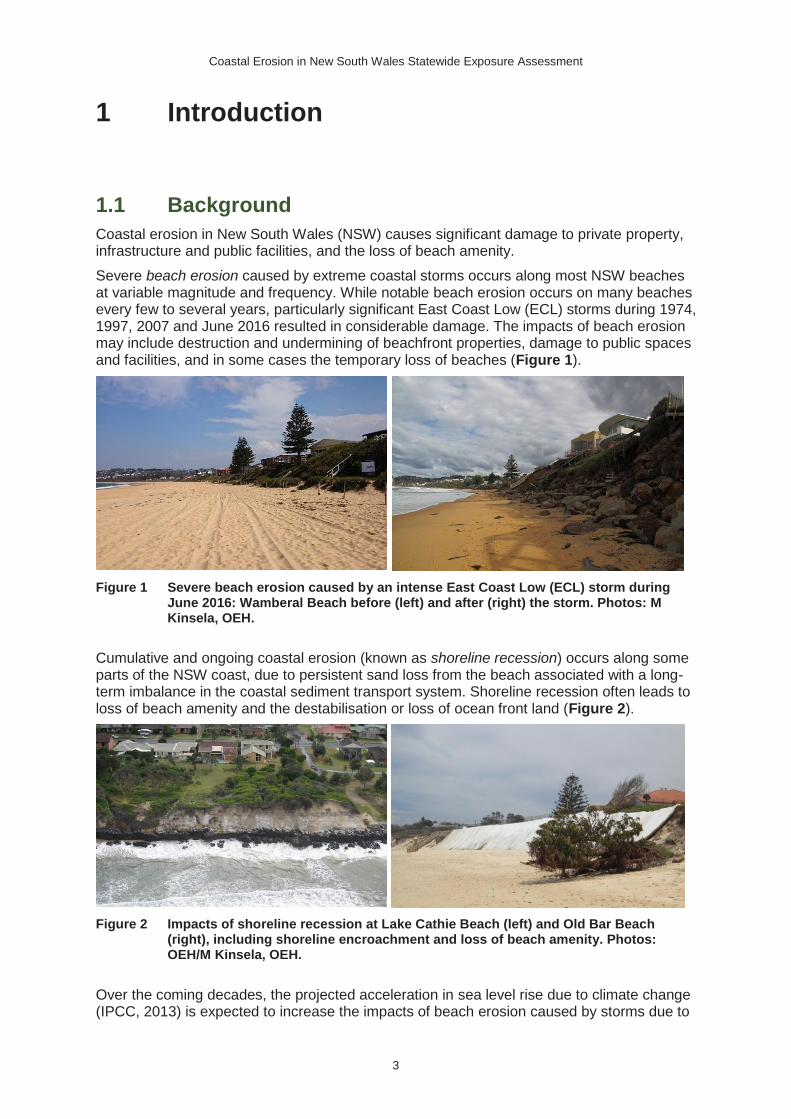
Coastal erosion in New South Wales (NSW) causes significant damage to private property, infrastructure and public facilities, and the loss of beach amenity.
Severe beach erosion caused by extreme coastal storms occurs along most NSW beaches at variable magnitude and frequency. While notable beach erosion occurs on many beaches every few to several years, particularly significant East Coast Low (ECL) storms during 1974, 1997, 2007 and June 2016 resulted in considerable damage. The impacts of beach erosion may include destruction and undermining of beachfront properties, damage to public spaces and facilities, and in some cases the temporary loss of beaches (Figure 1).
Figure 1 Severe beach erosion caused by an intense East Coast Low (ECL) storm during June 2016: Wamberal Beach before (left) and after (right) the storm. Photos: M Kinsela, OEH.
Cumulative and ongoing coastal erosion (known as shoreline recession) occurs along some parts of the NSW coast, due to persistent sand loss from the beach associated with a long-term imbalance in the coastal sediment transport system. Shoreline recession often leads to loss of beach amenity and the destabilisation or loss of ocean front land (Figure 2).
Figure 2 Impacts of shoreline recession at Lake Cathie Beach (left) and Old Bar Beach (right), including shoreline encroachment and loss of beach amenity. Photos: OEH/M Kinsela, OEH.
Over the coming decades, the projected acceleration in sea level rise due to climate change (IPCC, 2013) is expected to increase the impacts of beach erosion caused by storms due to

Coastal Erosion in New South Wales Statewide Exposure Assessment
4
higher storm surge water levels, and to increase rates of shoreline recession by changing the balance of sediment transport systems along some parts of the coast (Fitzgerald et al., 2008; Nicholls and Cazenave, 2010).
In general, the NSW coast is characterised by drift-aligned beaches shaped by alongshore processes in the north, and swash-aligned beaches shaped by cross-shore processes in the central and south (Roy and Thom, 1981). However, a range beach types occurs within either setting, varying with the surrounding geology, sediment properties, and exposure to waves.
NSW beaches may respond differently to storms and sea level rise depending on the local setting and their distinctive characteristics. This means that the predicted impact of coastal erosion at one beach may vary from surrounding beaches and other regions of the coast.
1.2 Aims and scope
This report presents a statewide assessment of exposure to coastal erosion in NSW. The assessment is intended to provide a broad-scale overview of the potential for present and future impacts to coastal settlements and communities.
The assessment is limited to considering beach erosion and shoreline recession on open-coast NSW beaches. An assessment of exposure to tidal inundation in estuaries, including the potential impacts of sea level rise, has been prepared separately.
The approach uses properties and roadways as a metric for the level of exposure, reflecting that at a statewide scale, impacts to other infrastructure, public facilities, and beach amenity, generally scale with the number of properties and lengths of roadways affected.
Three methods of estimating the potential extent of present and future coastal erosion are compared, in recognition that there is no single statewide consistent and definitive dataset that describes the present and future coastal erosion potential in NSW. The three methods reflect a hierarchy of detail and resolution, from generic (1st pass), to a more refined regional scale (2nd pass), and finally a site-specific local scale (3rd pass).
The first-pass method is based on a simple proximity analysis (Section 2.1), which presents the lengths of potentially erodible sandy shorelines that are close to existing development.
The second-pass method is based on a regional-scale coastal erosion modelling technique (Section 2.2) that has been applied to all NSW beaches. The modelling identifies properties and infrastructure that may be exposed to coastal erosion at present and at 2050 and 2100.
The third-pass method identifies properties and infrastructure that are affected by coastal erosion hazard lines that have been developed for local government councils (Section 2.3). The erosion hazard lines are based on various methods and data, and capture potential exposure at present and around 2050 and 2100.
It is important to note that the exposure assessment findings based on the second- and third-pass analyses are not directly comparable. Although the second-pass analysis is based on a statewide dataset (covering all relevant NSW beaches), the third-pass analysis is limited to beaches that have been considered in local government coastal hazard studies only. Thus, the second and third pass analyses do not consider the same number of NSW beaches.
1.3 Exposure, vulnerability and risk
This report is limited to considering exposure to coastal erosion. An exposure assessment simply identifies assets that may be impacted by a hazard (coastal erosion), based on data or modelling of the hazard. Equally exposed assets are not necessarily equally vulnerable to a hazard. The vulnerability of an asset depends on its specific characteristics and capacity to

Coastal Erosion in New South Wales Statewide Exposure Assessment
5
withstand the impacts of a hazard. Risk combines the likelihood of a hazard occurring with the potential impacts on an asset, as defined by the exposure and vulnerability of that asset.
Further details on natural hazards and risk language are provided by Geoscience Australia: Risk and Impact Analysis

Coastal Erosion in New South Wales Statewide Exposure Assessment
6
2 Methodology
There is no definitive statewide dataset that identifies coastal foreshore land in NSW that is presently affected by coastal erosion, or which may be affected by coastal erosion in future. Considering that, three alternative analysis methods are presented in this assessment, which are described in further detail throughout this section:
1. Proximity analysis (First pass)
2. Regional-scale modelling (Second pass)
3. Local government hazard lines (Third pass)
A spatial analysis toolset was developed to identify properties and infrastructure that may be exposed to coastal erosion, based on the second-pass and third-pass analysis methods.
2.1 Proximity analysis (First pass)
Due to the complexity of the NSW coastline and the diverse range of beach types, a simple proximity analysis was carried out as a first-pass coastal erosion exposure assessment.
The proximity analysis presented here identifies stretches of potentially erodible sandy coast featuring properties that may be affected by coastal erosion at present or in the future. The assessment is useful for identifying locations where coastal erosion may be an issue.
Smartline
The Smartline dataset was used to identify sandy shorelines along the NSW coast, and to identify parts of the coast that may be affected by coastal erosion. Smartline is a national geomorphic and stability map, which collates available data on the physical nature of the Australian coastline within a spatial dataset (Sharples et al., 2009a).
The base line to which Smartline data (e.g. shore type, substrate composition and stability class) is appended is the 1:25:000 scale Mean High Water Mark in NSW, as provided by the NSW Department of Lands (Sharples et al., 2009b). Thus, the proximity analysis described here is relative to the mean high-water mark defined by that dataset. Temporal variability in shoreline position implies that the position of the Smartline shoreline may not be consistent with the present shoreline, and the results should be considered with that in mind.
The first-pass exposure assessment was restricted to sandy beaches primarily influenced by open-coast processes. This is because the drivers of beach erosion and shoreline recession considered here are relevant to open-coast settings. The impacts of coastal storms and sea level rise in estuaries depend on the nature of the estuary system, and should be considered using different methods. Smartline was used to isolate open-coast sandy beaches from other shoreline types in NSW.
A distinction was also made between sandy shorelines that are known to be backed by hard substrate, from those either known or assumed to backed by a soft substrate. Where a soft backshore substrate occurs, the coast may be susceptible to enhanced beach erosion and shoreline recession, in response to a persistent sediment loss or sea level rise. In contrast, a hard backshore may restrict coastal erosion. It is important to note that only hard backshores that have been mapped and included within the Smartline dataset are considered.

Coastal Erosion in New South Wales Statewide Exposure Assessment
7
Proximity buffers
The first-pass assessment uses a proximity buffer technique to identify potentially erodible shorelines that are within close proximity to existing coastal development, which may be exposed to coastal erosion hazards at present or in the future.
A similar method was applied by the then Commonwealth Department of Climate Change in the report Climate Change Risks to Australia’s Coasts – A First-Pass National Assessment (DCC, 2009). They applied a 110-metre shoreline proximity buffer to capture potential shoreline recession driven by a 1.1 metre sea level rise.
Proximity buffers extending 55, 110 and 220 metres landward from open-coast sandy shorelines (i.e. Smartline mean high water mark) are considered here. The proximity buffers distances are intended to capture the potential range of shoreline change on NSW beaches, and may be interpreted as follows:
• a 55-metre buffer may identify areas of potential immediate risk due to shoreline variability associated with severe storms and/or periodic beach rotation
• a 110-metre buffer may identify areas of potential future risk due to shoreline variability and moderate shoreline recession driven by sea level rise (e.g. 0.5-1 metre sea level rise with a Bruun factor of 50-100), or by combined sea level rise and gradual underlying sand loss
• a 220-metre buffer may identify areas of potential future risk due to shoreline variability and severe shoreline recession driven by sea level rise (e.g. 1.5 metre SLR with a Bruun factor of 100), or by combined sea level rise and rapid underlying sand loss.
The proximity buffers are generic in nature and are not intended to represent any particular forecast period, scenario, or setting. Rather, they capture the range of potential responses for a spectrum of coastal settings and climate change scenarios.
Considering that an average beach width (the distance between the mean high water mark and foredune) in NSW may be 30-40 metres, and an indicative distance for severe erosion into a foredune may be 15-25 metres, use of a 55 metre buffer to identify the potential extent of immediate risk seems reasonable. The 110-metre and 220 metre buffers are intended to capture variability and uncertainty in: (1) future sea level rise; (2) the magnitude of beach response to sea level rise (i.e. the Bruun factor); and, (3) underlying sand losses relevant to some NSW beaches.
The proximity buffers were used to identify stretches of open-coast sandy shoreline that are located within 55, 110 and 220 metres of existing properties.
2.2 Regional-scale modelling (Second pass)
The second-pass assessment method is based on a regional-scale coastal erosion modelling method that was applied to all NSW beaches. The datasets identify land potentially exposed to coastal erosion at present and in the future, across a range of probability thresholds that describe the relative likelihood of exposure to coastal erosion.
The regional-scale modelling method is described in detail in OEH (2017). The method uses a sediment-compartment templating approach (e.g. Cowell et al., 2003; Eliot et al., 2011) to characterise the morphology and sediment budgets of NSW beaches. Both regional-scale and site-specific (where available) data are applied to forecast the potential volume of coastal erosion, and erosion distances are calculated using high-resolution LiDAR topography data. A probabilistic framework (Cowell et al., 2006, Wainwright et al., 2015; Kinsela et al., 2016) is used to consider uncertainty in model inputs, which is communicated

Coastal Erosion in New South Wales Statewide Exposure Assessment
8
in the model forecasts by expressing the range of predicted coastal erosion in terms of exceedance probabilities.
The regional-scale modelling erosion hazard lines differ from local government hazard lines (Section 2.3). While the former is based on a uniform method applied to all NSW beaches, the latter are based on various methods suited to different parts of the NSW coast.
2.3 Local government hazard lines (Third pass)
Coastal erosion hazard lines have been derived by engineering consultants for most local government areas (LGAs) of NSW. Coastal erosion hazard lines are usually defined as part of the coastal hazard definition study component of coastal zone management plans. The hazard lines define the anticipated extent of coastal erosion for particular planning periods, and are intended as a guide for managing development in the coastal zone. Typical planning periods considered are immediate (present), 50 years (e.g. 2050) and 100 years (e.g. 2100).
The techniques used to derive coastal erosion hazard lines vary between LGAs and between practitioners (Kinsela & Hanslow, 2013; Wainwright et al., 2014). That is, the hazard lines for each LGA are not necessarily derived using the same assessment approaches. However, it is assumed that the techniques adopted in each study are appropriate for and representative of the different settings considered, and here the erosion hazard lines for each LGA are considered equally for each planning period.
Erosion hazard lines are not available for all NSW beaches. Appendix A describes available hazard data at the time of preparation of this report, and which was applied in the third-pass analysis method. Only erosion hazard lines developed after 2008 were considered, as earlier datasets are based on outdated sea level rise projections.
It is customary in NSW to consider multiple definitions of the potential impact of erosion for each planning period or scenario. To differentiate between direct (undermining) and indirect (ground instability) impacts, erosion hazard lines are often defined at the landward limits of the zone of slope adjustment (ZSA) and zone of reduced foundation capacity (ZRFC). The ZSA represents the area subject to slope failure following dune erosion, whereas the ZRFC identifies the area beyond a fully adjusted erosion scarp that may be susceptible to instability and weakened foundation capacity (Figure 3).
Figure 3 Dune adjustment and stability zones following an erosion event (Nielsen et al., 1992). The zone of reduced foundation capacity represents unstable land beyond the erosion scarp.
Although there may be risk to properties with unpiled foundations within the ZRFC, it is most common to define erosion hazard lines at the ZSA, and such hazard lines were available for most LGAs (see Appendix A). Therefore, the third-pass assessment identifies properties

Coastal Erosion in New South Wales Statewide Exposure Assessment
9
that may be affected by coastal erosion as defined by council's ZSA erosion hazard lines, using the method described in Section 2.4.
2.4 Analysis of affected properties and infrastructure
A spatial analysis toolset was developed to identify properties and infrastructure that may be exposed to coastal erosion, based on the second-pass and third-pass analysis methods. The tools use Python and ArcGIS to query property and infrastructure data with hazard datasets.
GURAS property data
Both the Cadastre and the Geo-coded Urban and Rural Address System (GURAS) database were used to identify properties that are potentially exposed to coastal erosion. The GURAS database is the authoritative property addressing dataset for NSW and is managed by NSW Government Spatial Services.
The GURAS database was used as the primary property dataset because the Cadastre does not describe the address/es associated with each property lot. For example, some cadastral lots may contain numerous addresses, whilst some addresses may occupy multiple cadastral lots. Furthermore, the cadastre includes many unsold and/or undeveloped lots (particularly in the coastal zone) that have been preserved as public spaces, and which should therefore be excluded from the exposure assessment.
In GURAS, address point data is stored within each property lot. The database distinguishes between primary addresses (e.g. houses, strata blocks) and secondary addresses (e.g. units and apartments), which is relevant for assessing exposure to coastal hazards. For example, in the context of coastal erosion, it may not be prudent to restrict an assessment to primary addresses, as structural damage to a strata building (i.e. from wave impact or undermining) may impact multiple secondary addresses (apartments) within the strata block.
The nature of the database is described by NSW Government Spatial Services as follows:
‘The Geocoded Urban and Rural Address System (GURAS) is a ‘Property’ based address database. A property is based on the definition recorded by the Valuer General’s Department in their ValNet database. Each property polygon captured within GURAS has a unique numeric identifier, as defined by ValNet and is known as the ‘propid’. Each property contains at least one authoritative address which is sourced from local councils via ValNet. Properties may contain more than one address sourced from various other organisations eg. AusPost. It is important to note that Address Points are generally system generated points and therefore do not always have a direct correlation to the dwelling location. In circumstances where there are multiple disparate lots for the one property, particularly in rural addresses, the system generated Address Points may not reside within the correct property polygon.’
The GURAS database also contains coded and text identifiers, which may be used to select and discard unwanted registered addresses (e.g. public spaces and infrastructure, such as beaches, reserves, car parks, wharfs, utilities etc.) prior to calculating exposure statistics.
Property analysis
A coastal hazard exposure assessment tool has been developed by OEH to inform coastal risk analysis. The Python-based tool reads mapped hazard areas, defined as GIS polygons, and calculates the number of exposed properties, and number and dimensions of selected infrastructure, within a specified analysis area (e.g. LGA). As such, polygons representing

Coastal Erosion in New South Wales Statewide Exposure Assessment
10
the second-pass (Section 2.2) and third-pass (Section 2.3) analysis methods were created by closing the lateral boundaries between the hazard lines and shoreline (i.e. Smartline).
The outputs of the exposure assessment tool that are considered here include:
1. lengths of sandy shorelines proximal to properties (i.e. within the proximity buffers)
2. number of addresses partially or wholly contained within each erosion hazard polygon
Considering that GURAS address data is stored in GIS point datasets, a method was created to select address points that are associated with potentially exposed property lots, whether or not the address point itself is actually contained within the erosion hazard polygon. Moreover, given that the GURAS database includes arbitrary registered addresses (e.g. public spaces and utilities) a procedure was also developed to restrict identified addresses points to those associated with occupied (i.e. sold or developed) properties only.
The address selection procedure included the following steps:
• erosion hazard polygons were overlain on Cadastre lot data to identify exposed lots
• calculation of the proportion of the lot actually affected by the erosion hazard polygon
• exposed lots were used to select all GURAS address points contained within each lot
• Crown Land and National Parks datasets were used to exclude any address points associated with either land tenure type
• ‘exposed’ address points were queried to remove any remaining addresses associated with public spaces (e.g. reserves, sports fields, ocean baths), public infrastructure (e.g. car parks, wharfs) or utilities (e.g. electricity, telecommunications).
The GURAS database does not store information on the locations of assets in each property lot –address points are typically located in the centre of the associated property lot. Thus, properties identified as exposed do not necessarily imply that an asset is exposed to coastal erosion. Rather, exposed properties may be wholly or partially (i.e. part of the lot) affected by coastal erosion, and in the latter case assets may be set back from the exposed land.
To provide a sense of the relative impact of coastal erosion on potentially exposed properties the exposure assessment tool also determines the proportion (area) of each property lot that is potentially affected by coastal erosion. Figure 4 shows an example of the spatial overlay method, which categorises exposed address points based on the proportion-of-lot affected.

Coastal Erosion in New South Wales Statewide Exposure Assessment
11
Figure 4 Example of the spatial overlay method used to calculate the proportion of each lot potentially affected by coastal hazards. In this example of inundation hazard layers, address points of exposed properties are colour coded based on the proportion of the property lot that is affected by the '100-YR ARI +0.9m' elevated water level scenario (light blue shading).
Figure 5 illustrates the approach used to select only valid addresses from the GURAS database. First, addresses located within Crown Lands and National Parks were removed. Second, any remaining addresses associated with public spaces, infrastructure or utilities were removed using GURAS text tags. Lastly, remaining valid addresses were divided into primary and secondary addresses to allow separate analysis of the different address types.
Because GURAS is a ‘property’ address database that is based on the Valuer General’s database (ValNet), there is high confidence that the address points preserved at the end of the address selection procedure are valid properties. While it remains possible that a small number of arbitrary registered addresses (e.g. public spaces and utilities) were preserved in the exposure statistics reported here, a limited manual review suggests that any errors are negligible in the context of the statewide exposure assessment.

Coastal Erosion in New South Wales Statewide Exposure Assessment
12
Figure 5 Procedure to identify 'valid' addresses in the coastal erosion exposure assessment.
Infrastructure analysis
The spatial analysis toolset features various infrastructure and utilities datasets in point, line and polygon geometries. For ease of communication only roadway exposure is presented in this assessment, as many other infrastructure and utilities types scale linearly with roadways, particularly when considering exposure statistics at regional or state-wide scales.
Similar to the property analysis, an overlay method was used to identify lengths of roadways that are affected by the various second- and third-pass erosion hazard datasets. The lengths of affected roadways were summed by LGA, and aggregated for the NSW regions and statewide exposure statistics. The roadways dataset is categorised into (increasing significance): vehicular track, local, arterial, primary and motorway. The roadways data was sourced from NSW Government Roads and Maritime Services.
Analysis regions
Exposure assessment statistics for the second-pass (Section 4) and third-pass (Section 5) analyses are provided at three spatial scales: statewide, NSW regions and local government areas. Figure 6 shows the distribution of and relationships between the state-, regional-, and local-scale analysis regions. The local government area boundaries considered were current at the time of preparation of this report.

Coastal Erosion in New South Wales Statewide Exposure Assessment
13
Figure 6 Extent and distribution of coastal NSW regions and local government areas (LGAs) that are referred to in this report. LGA boundaries considered are current at January 2016.

Coastal Erosion in New South Wales Statewide Exposure Assessment
14
3 Proximity analysis (First pass)
The Smartline dataset indicates that of the 2065 kilometres of NSW shorelines exposed to open-coast processes, 1038 km or 50% are classified as sandy shorelines (sandy shorelines that are primarily influenced by open-coast processes). Of all sandy open-coast shorelines, 15% are known to be backed by ‘hard’ backshore substrate types, whilst 85% are either known or assumed to be backed by ‘soft’ backshore substrate types (Table 1). The reader is reminded that ‘hard’ backshore types considered here only include those that have been mapped and included in the Smartline dataset, and may be composed of natural and/or artificial materials.
The findings of the first-pass exposure assessment based on the proximity analysis method are summarised in Table 1 and Figure 7. The assessment identified 54 kilometres of sandy open-coast shorelines located within 55 metres of properties. Properties adjacent to these shorelines are very likely to be located within the erosion hazard exposure zone for the purposes of coastal management and planning. Although one-third of those shorelines were identified as hard backshore substrate, these substrates were found to include seawalls and promenades that may not necessarily withstand the impacts of coastal erosion (i.e. not designed for the purpose of coastal protection). Thus, a precautionary approach would be to consider the total lengths of exposed shorelines in Table 1.
Table 1 Results of first-pass exposure assessment based on the proximity analysis method. Lengths of sandy open-coast shorelines within or backed by National Parks, and within 220 m, 110 m and 55 m of properties are shown. Square brackets '[ ]' indicate the percentage of each shoreline category as a proportion of total NSW open-coast sandy shorelines. Parentheses '( )' indicate the percentage of soft and hard backshores for each sandy shoreline subcategory.
Shoreline category Total length (km) Soft backshore (km) Hard backshore (km)
NSW open-coast 2065 - -
Sandy open-coast only 1038 883 (85%) 155 (15%)
within National Parks* 491 [47%] 426 (87%) 65 (13%)
220 m of properties 305 [29%] 234 (77%) 71 (23%)
110 m of properties 147 [14%] 106 (72%) 41 (28%)
55 m of properties 54 [5.2%] 36 (66%) 18 (34%)
* shorelines located within or immediately backed by (within 110 m of) National Parks.
The findings also show that 93 kilometres of sandy open-coast shorelines are located between 55 metres and 110 metres of properties - i.e. the total shorelines located within 110 metres of properties (147 kilometres) excluding those within 55 metres of properties (54 kilometres). These additional shorelines identify areas that may be exposed to coastal erosion within current planning periods (e.g. by 2100), due to the combined impacts of beach erosion and shoreline recession in response to sea level rise and/or underlying sand losses.
A further 158 kilometres of sandy open-coast shorelines were identified as located between 110 metres and 220 metres of properties. These additional shorelines identify areas that are less likely to be exposed to coastal erosion within current planning periods, except where rapid shoreline recession due to persistent sand losses are ongoing. However, areas where sandy open-coast shorelines are within 220 metres of properties may be exposed to coastal

Coastal Erosion in New South Wales Statewide Exposure Assessment
15
erosion beyond current planning periods, if the projected acceleration of sea level rise is realised.
Figure 7 Lengths of open-coast sandy shorelines in NSW that are backed by soft backshore types [solid] and hard backshore types only [stroked] according to Smartline. Total shoreline lengths, shoreline lengths within or backed by National Parks (NPs), and shoreline lengths within 220 m, 110 m and 55 m of properties are shown.
Figure 8 shows the distribution of NSW sandy open-coast shorelines located within National Parks, and within 55, 110 and 220 metres of properties. The distribution suggests that while only 5% of potentially erodible NSW sandy open-coast shorelines were characterised as located within 55 metres of properties, the distribution of these areas exceeds the distribution of the nominated coastal erosion 'hot spots’.
The coastal erosion hot spots have been established to prioritise coastal areas currently at high risk from erosion hazards. As such, the additional areas identified as having properties located within 55 metres of potentially erodible shorelines may indicate the potential for broader exposure to coastal erosion in the immediate future, due to a period of intense storm activity. Where coastal protection measures are already in place, the analysis highlights that they will require ongoing maintenance to withstand increasing coastal erosion pressure under current projections of sea level rise over the coming decades.
Appendix B presents a breakdown of the proximity analysis findings for each LGA. Plots and maps similar to Figure 7 and Figure 8 are provided for each LGA. It should be noted that the proximity analysis was carried out using LGA boundaries current in 2014. This does not influence the statewide results, although the reader should bear in mind that some LGA boundaries have changed.

Coastal Erosion in New South Wales Statewide Exposure Assessment
16
Figure 8 NSW sandy open-coast shorelines located in close proximity (i.e. 55, 110, 220 m) to properties, or within National Parks. The locations of nominated erosion hot spots are shown. Appendix B provides a breakdown of this map for each coastal LGA.

Coastal Erosion in New South Wales Statewide Exposure Assessment
17
4 Regional-scale modelling (Second pass)
The second pass analysis provides a consistent and state wide coastal erosion exposure assessment based on regional-scale probabilistic coastal erosion hazard modelling of most NSW beaches. Given the increased uncertainty associated with long-term forecasts, a higher exceedance level (50%) representing a mid-range prediction was adopted for the 2100 forecast, whereas low exceedance (1%) or high-range predictions were considered for the present and 2050 forecasts, which are characterised by lower uncertainty.
4.1 Statewide
The regional-scale analysis indicates that approximately 1200 properties may be affected by coastal erosion under present conditions (1% exceedance), rising to around 3100 and 4800 properties at 2050 (1% exceedance) and 2100 (50% exceedance) (Figure 9).
The total numbers of exposed properties are categorised by the proportion of each property lot potentially affected by coastal erosion in Figure 9 to provide a sense of the relative impact of coastal erosion on exposed properties. Warmer colours indicate higher impacts.
Figure Primary address exposure throughout NSW for the present-1%, 2050-1% and 2100-50% scenarios. Colouring indicates the proportion of each property lot potentially affected by coastal erosion.
When considering the total property exposure to coastal erosion – i.e. including secondary addresses associated with affected primary addresses – the numbers of properties potentially affected for present (1% exceedance), 2050 (1% exceedance) and 2100 (50% exceedance) scenarios, increase to around 2300, 5200 and 8200 respectively (Figure 10). Note that the vertical axis scale is twice that of Figure 9.
The categorisation by the proportion of each property lot that is potentially affected by coastal erosion is similar to Figure 9 because the same primary (lot) addresses are considered.

Coastal Erosion in New South Wales Statewide Exposure Assessment
18
An increase in any category in Figure 10 indicates that a large number of secondary addresses are associated with affected property lots in that proportion-of-lot category.
Figure 10 Total property exposure (includes secondary addresses) throughout NSW for the present-1%, 2050-1% and 2100-50% scenarios. Colouring indicates the proportion of each property lot potentially affected by coastal erosion.
The total lengths of roadways potentially affected by coastal erosion follows a similar trend to affected properties. Figure 11 shows that about 70 kilometres of NSW roadways may be exposed to coastal erosion at present (1% exceedance).
For the 2050 (1% exceedance) and 2100 (50% exceedance) scenarios, total lengths of exposed roadways increases to 196 kilometres and 311 kilometres respectively.
At present vehicular tracks make up the majority of roadway exposure behind NSW beaches. However, the analysis shows that increasing lengths of local and arterial roads are affected by the 2050 and 2100 scenarios.
No primary roadways or motorways are affected according to the regional-scale analysis.

Coastal Erosion in New South Wales Statewide Exposure Assessment
19
Figure 11 Roadway exposure throughout NSW for the present-1%, 2050-1% and 2100-50% scenarios. Colouring indicates the types of roadways potentially affected by coastal erosion.
4.2 NSW regions
The regional-scale analysis suggests that all NSW regions except Hunter and South East have considerable exposure to coastal erosion at present (1% exceedance), while exposure at 2050 (1% exceedance) and 2100 (50% exceedance) increases most significantly in the Northern Rivers, Mid North Coast Illawarra-Shoalhaven regions (Figure 12).
Large increases in the numbers of addresses for which greater that 50% of the property lot (orange and red shading) is affected by modelled coastal erosion highlights regions where there may be very significant increase in the impacts of coastal erosion this century. Figure 12 suggests that all NSW regions, are characterised by significant increase in exposure to coastal erosion during this century, based on current development.
Any future unmitigated development within council erosion hazard lines would increase the numbers of properties exposed to coastal erosion based on the 2050 and 2100 scenarios.

Coastal Erosion in New South Wales Statewide Exposure Assessment
20
Figure 12 Primary address exposure by NSW regions for the present-1% (left), 2050-1% (middle) and 2100-50% (right) scenarios. Colouring indicates the proportion of each property lot potentially affected by coastal erosion.
Considering the total property exposure to coastal erosion (including secondary addresses
associated with affected primary addresses), the numbers of properties potentially affected
by coastal erosion is about 1.5 to 2 times the primary address exposure for the Northern
Rivers, Mid North Coast, Central Coast and Greater Sydney regions (Figure 13). Note that
the vertical axis scale is twice that of Figure 12.
The limited abundance of affected multi-dwelling coastal properties in the Hunter, Illawarra-
Shoalhaven and South East regions is indicated in minimal or no increase in the exposure
statistics between Figure 12 and Figure 13.
The categorisation by the proportion of each property lot that is potentially affected by coastal erosion is similar to Figure 12 because the same primary (lot) addresses are considered. An increase in any category in Figure 13 indicates that a large number of secondary addresses are associated with affected property lots in that proportion-of-lot category.
Coastal Erosion in New South Wales Statewide Exposure Assessment
21
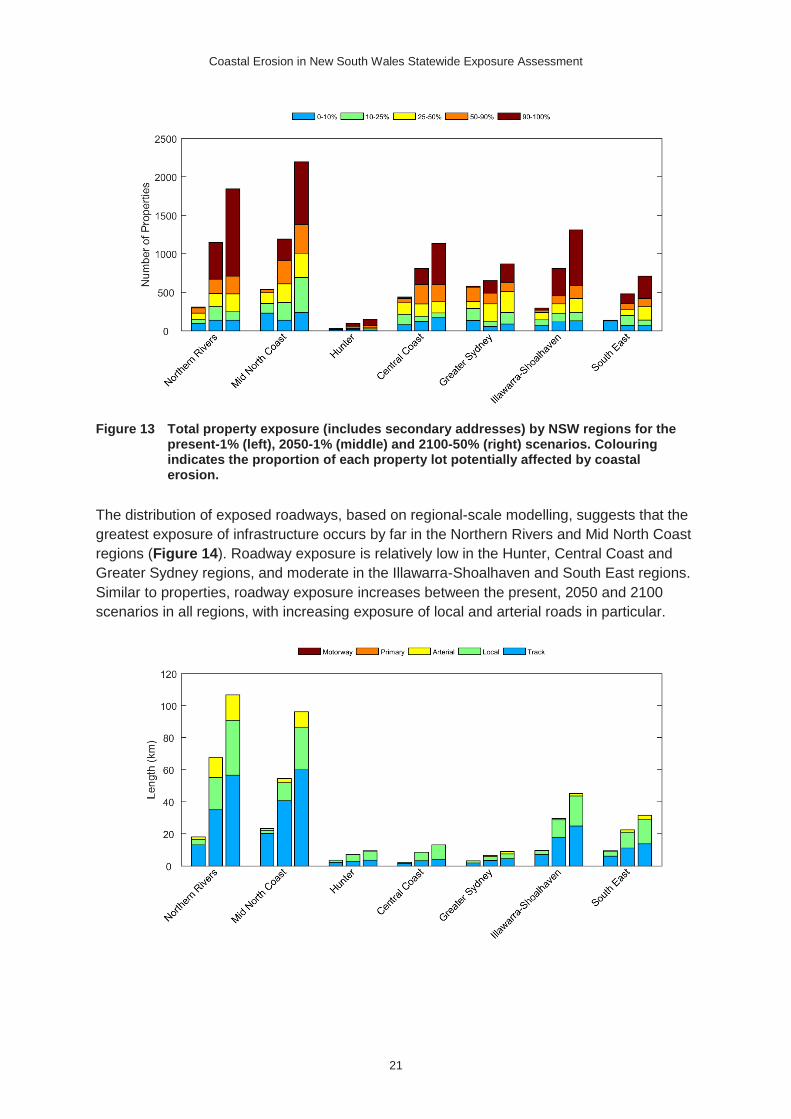
Figure 13 Total property exposure (includes secondary addresses) by NSW regions for the present-1% (left), 2050-1% (middle) and 2100-50% (right) scenarios. Colouring indicates the proportion of each property lot potentially affected by coastal erosion.
The distribution of exposed roadways, based on regional-scale modelling, suggests that the
greatest exposure of infrastructure occurs by far in the Northern Rivers and Mid North Coast
regions (Figure 14). Roadway exposure is relatively low in the Hunter, Central Coast and
Greater Sydney regions, and moderate in the Illawarra-Shoalhaven and South East regions.
Similar to properties, roadway exposure increases between the present, 2050 and 2100
scenarios in all regions, with increasing exposure of local and arterial roads in particular.

Coastal Erosion in New South Wales Statewide Exposure Assessment
22
Figure 14: Roadway exposure by NSW regions for the present-1% (left), 2050-1% (middle) and 2100-50% (right) scenarios. Colouring indicates the types of roadways potentially affected by coastal erosion.
4.3 Local government areas
The comparison of exposure statistics between LGAs adds an additional level of resolution to the regional analysis. As is expected, the distribution of exposure follows a similar pattern to the regional breakdown, although it is evident that particular LGAs represent the majority of exposure in their respective regions.
Central Coast and Northern Beaches LGAs have the highest exposure to coastal erosion at present, while Shoalhaven LGA also has high exposure although mostly in the less than 50% proportion-of-lot categories (Figure 15). The analysis also suggests that exposure to coastal erosion will increase considerably for many LGAs over the present century.
As is reflected in the state wide and regional analyses, the numbers of properties for which greater that 50% of the property lot (orange and red shading) is affected by council erosion hazard lines increases markedly for most LGAs for the 2050 and 2100 scenarios.
Figure 15 Primary address exposure by local government area for present-1% (left), 2050-1% (middle) and 2100-50% (right) scenarios. Colouring indicates the proportion of each property lot potentially affected by coastal erosion.
Considering the total property exposure to coastal erosion (including secondary addresses associated with affected primary addresses) highlights the influence of high development concentration in the coastal zone on exposure.
Compared with affected primary addresses, or lots (Figure 15), total numbers of properties potentially exposed to coastal erosion roughly double for Byron, Ballina, Coffs Harbour, Mid Coast, Central Coast and Northern Beaches LGAs (Figure 16). This indicates that there is a high proportion of secondary addresses (units, apartments) that are associated with potentially exposed property lots in those LGAs.

Coastal Erosion in New South Wales Statewide Exposure Assessment
23
Figure 16 Total property exposure (includes secondary addresses) by local government area for present-1% (left), 2050-1% (middle) and 2100-50% (right) scenarios. Colouring indicates the proportion of each property lot potentially affected by coastal erosion.
The distribution of roadways that are potentially exposed to coastal erosion reflects the NSW regions breakdown, with far north and mid north coast LGAs having the highest exposure (Figure 17).
While, the majority of present exposure is vehicular tracks, which generally have minimal infrastructure, increasing proportions of local and arterial roadways are likely to be exposed to coastal erosion through this century.

Coastal Erosion in New South Wales Statewide Exposure Assessment
24
Although Central Coast LGA has high property exposure, infrastructure exposure appears to be relatively average compared with other NSW LGAs.
Figure 17: Roadway exposure by local government area for present-1% (left), 2050-1% (middle) and 2100-50% (right) scenarios. Colouring indicates the types of roadways potentially affected by coastal erosion.

Coastal Erosion in New South Wales Statewide Exposure Assessment
25
5 Local government hazard lines (Third
pass)
The third pass analysis provides a state wide coastal erosion exposure assessment based on local government erosion hazard lines. The reader is reminded that the spatial coverage of council datasets is incomplete and does not cover all NSW beaches, and the aggregated statistics presented below must be interpreted with that in mind.
Appendix A documents the coastal hazard studies associated with erosion hazard line data that was applied in the third-pass exposure assessment. The reader is referred to those studies for further information on data coverage, and the methods used to generate erosion hazard lines for each LGA.
5.1 Statewide
The statewide analysis indicates that approximately 1000 properties are affected by council erosion hazard lines that represent present erosion risk, and that number rises to 2000 and almost 3500 properties for 2050 and 2100 erosion hazard lines respectively (Figure 17).
The total numbers of exposed properties are categorised by the proportion of each property lot affected by council erosion hazard lines in Figure 17 to provide a sense of the relative impact of coastal erosion on exposed properties. Warmer colours indicate higher impacts.
Figure 17 Primary address exposure throughout NSW for present, 2050 and 2100 scenarios. Colouring indicates the proportion of each property lot potentially affected by coastal erosion.
When considering the total property exposure to coastal erosion – i.e. including secondary addresses associated with affected primary addresses – the numbers of properties affected roughly double for the present, 2050 and 2100 scenarios, to around 2000, 3700 and 6800 respectively (Figure 18). Note that the vertical axis scale is twice that of Figure 17.

Coastal Erosion in New South Wales Statewide Exposure Assessment
26
The categorisation by the proportion of each property lot that is affected by council hazard lines is similar to Figure 17 because the same primary (lot) addresses are considered. An increase in any category in Figure 18 indicates that a large number of secondary addresses are associated with affected property lots in that proportion-of-lot category.
Figure 18 Total property exposure (includes secondary addresses) throughout NSW for present, 2050 and 2100 scenarios. Colouring indicates the proportion of each property lot potentially affected by coastal erosion.
The total lengths of roadways affected by council erosion hazard lines follows a similar trend to affected properties. Figure 19 shows that about 50 kilometres of roadways are currently exposed to coastal erosion according to council hazard lines. For the 2050 and 2100 scenarios, total lengths of exposed roadways increases to 90 kilometres and 160 kilometres respectively.
At present vehicular tracks make up the majority of roadway exposure behind NSW beaches. However, the analysis shows that increasing lengths of local and arterial roads are affected by the various 2050 and 2100 scenarios. No primary roadways or motorways are affected by council erosion hazard lines.

Coastal Erosion in New South Wales Statewide Exposure Assessment
27
Figure 19 Roadway exposure throughout NSW for present, 2050 and 2100 scenarios. Colouring indicates the types of roadways potentially affected by coastal erosion.
5.2 NSW regions
The regional analysis suggests that despite being the smallest of the NSW regions the Central Coast has the greatest number of primary addresses affected by council erosion hazard lines that represent present erosion risk, while exposure based on the various 2050 and 2100 scenarios increases markedly in the Northern Rivers and Mid North Coast regions in particular (Figure 20).
Large increases in in the numbers of addresses for which greater that 50% of the property lot (orange and red shading) is affected by council erosion hazard lines highlights regions where there may be very significant increase in exposure to coastal erosion this century. Figure 20 suggests that all NSW regions, except the South East, will likely feature a significant increase in exposure to coastal erosion during this century, based on current development.
Any future unmitigated development within council erosion hazard lines would increase the numbers of properties exposed to coastal erosion based on the 2050 and 2100 scenarios.
Coastal Erosion in New South Wales Statewide Exposure Assessment
28
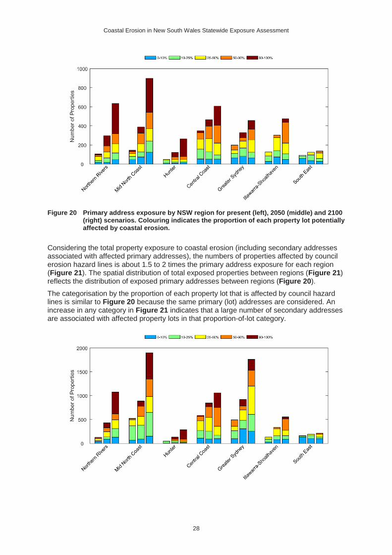
Figure 20 Primary address exposure by NSW region for present (left), 2050 (middle) and 2100 (right) scenarios. Colouring indicates the proportion of each property lot potentially affected by coastal erosion.
Considering the total property exposure to coastal erosion (including secondary addresses associated with affected primary addresses), the numbers of properties affected by council erosion hazard lines is about 1.5 to 2 times the primary address exposure for each region (Figure 21). The spatial distribution of total exposed properties between regions (Figure 21) reflects the distribution of exposed primary addresses between regions (Figure 20).
The categorisation by the proportion of each property lot that is affected by council hazard lines is similar to Figure 20 because the same primary (lot) addresses are considered. An increase in any category in Figure 21 indicates that a large number of secondary addresses are associated with affected property lots in that proportion-of-lot category.

Coastal Erosion in New South Wales Statewide Exposure Assessment
29
Figure 21 Total property exposure (includes secondary addresses) by NSW region for present (left), 2050 (middle) and 2100 (right) scenarios. Colouring indicates the proportion of each property lot potentially affected by coastal erosion.
The distribution of exposed roadways, based on council erosion hazard lines, suggests that the greatest exposure of infrastructure occurs in the Northern Rivers and Mid North Coast regions (Figure 22). Roadway exposure is relatively similar between the other regions, despite considerable variation in the geographic extent of each region (Figure 6). Similar to properties, roadway exposure increases between the present, 2050 and 2100 scenarios in all regions, with increasing exposure of local and arterial roads in particular.
Figure 22 Roadway exposure by NSW region for present (left), 2050 (middle) and 2100 (right) scenarios. Colouring indicates the types of roadways potentially affected by coastal erosion.
5.3 Local government areas
The comparison of exposure statistics between LGAs adds an additional level of resolution to the regional analysis. As is expected, the distribution of exposure follows a similar pattern to the regional breakdown, although it is evident that particular LGAs represent the majority of exposure in their respective regions.
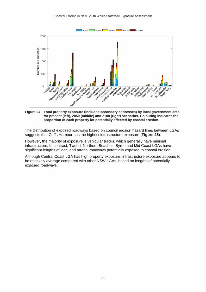
Central Coast LGA has the highest exposure to coastal erosion, based on council erosion hazard lines, followed by Northern Beaches and Coffs Harbour (Figure 23). The analysis also suggests that Byron, Clarence Valley, Mid Coast, Newcastle and Shoalhaven LGAs have particularly high exposure to coastal erosion.
As is reflected in the state wide and regional analyses, the numbers of properties for which greater that 50% of the property lot (orange and red shading) is affected by council erosion hazard lines increases markedly for most LGAs for the 2050 and 2100 scenarios.

Coastal Erosion in New South Wales Statewide Exposure Assessment
30
Figure 23 Primary address exposure by local government area for present (left), 2050 (middle) and 2100 (right) scenarios. Colouring indicates the proportion of each property lot potentially affected by coastal erosion.
Considering the total property exposure to coastal erosion (including secondary addresses associated with affected primary addresses) highlights the influence of high development concentration in the coastal zone on exposure.
Compared with affected primary addresses, or lots (Figure 23), the total number of properties potentially exposed to coastal erosion triples for Northern Beaches and Coffs Harbour LGAs, and doubles for Central Coast LGA (Figure 24).
This indicates that in those LGAs there is a high proportion of secondary addresses (units, apartments) associated with property lots that are affected by council erosion hazard lines.
Coastal Erosion in New South Wales Statewide Exposure Assessment
31
Figure 24 Total property exposure (includes secondary addresses) by local government area for present (left), 2050 (middle) and 2100 (right) scenarios. Colouring indicates the proportion of each property lot potentially affected by coastal erosion.
The distribution of exposed roadways based on council erosion hazard lines between LGAs suggests that Coffs Harbour has the highest infrastructure exposure (Figure 25).
However, the majority of exposure is vehicular tracks, which generally have minimal infrastructure. In contrast, Tweed, Northern Beaches, Byron and Mid Coast LGAs have significant lengths of local and arterial roadways potentially exposed to coastal erosion.
Although Central Coast LGA has high property exposure, infrastructure exposure appears to be relatively average compared with other NSW LGAs, based on lengths of potentially exposed roadways.

Coastal Erosion in New South Wales Statewide Exposure Assessment
32
Figure 25 Roadway exposure by local government area for present (left), 2050 (middle) and 2100 (right) scenarios. Colouring indicates the types of roadways potentially affected by coastal erosion.

Coastal Erosion in New South Wales Statewide Exposure Assessment
33
6 Summary of exposure to coastal erosion
This assessment of exposure to coastal erosion presents the findings of three alternative analysis techniques, which vary in spatial coverage, complexity and detail. Each analysis provides useful information at different spatial scales, and the findings must be interpreted in the context of the coverage and limitations of each analysis technique.
6.1 Extent and distribution
The proximity analysis (First pass) identifies parts of the NSW coastline where properties are situated in close proximity to sandy open-coast shorelines that may be susceptible to coastal erosion. The method does not consider the influences of regional- or local-scale morphology and processes on potential coastal erosion.
The analysis indicates that all coastal regions of NSW feature settlements and properties that may be affected by coastal erosion at present or in the future, due to their close proximity to potentially erodible sandy open-coast shorelines (Figure 8). The occurrence of potentially high-risk locations where properties lie within 55 metres of the shoreline exceeds the distribution of the 15 nominated coastal erosion 'hot spots' (Appendix A).
The assessment suggests that central and southern NSW have more settlements that are in very close proximity to open-coast sandy beaches. However, although northern NSW does feature considerable spans of unpopulated beaches, often located within National Parks (Figure 8), exposed settlements are characterised by a higher concentration of properties (Figure 12), and often include multi-dwelling properties with additional secondary addresses (Figure 13). Furthermore, the geomorphology of southern NSW - rugged, embayed, and with frequent bedrock – affords some protection to many coastal settlements, and assets on many rural properties are set farther landward of seaside property boundaries.
6.2 Regional-scale analysis
The regional-scale modelling analysis (Second pass) provides the only state-wide and consistent analysis of coastal erosion exposure in NSW, making it the most suitable for investigating the regional distribution of property and infrastructure exposure.
The second-pass assessment identified approximately 1200 properties that may be affected by coastal erosion under present conditions (1% exceedance level), rising to around 3100 properties at 2050 (1% exceedance level) and 4800 properties at 2100 (50% exceedance level) (Figure 9). Considering the increased uncertainty associated with long-term forecasts, a higher exceedance level representing a mid-range prediction was adopted for the 2100 forecast, whereas low exceedance or high-range predictions were considered for the present and 2050 forecasts, which are characterised by lower uncertainty.
For every region, the majority of growth in exposure numbers between present and future scenarios was properties for which >50% of the property lot was predicted to be affected by coastal erosion (Figure 12), a pattern that is reflected in the state-wide statistics (Figure 9).
When including secondary addresses within multi-dwelling properties, the total numbers of potentially affected properties increase to 2300 at present, 5200 at 2050, and 8200 at 2100 (Figure 10). As a general rule, considering secondary addresses (e.g. units and apartments) increased exposure numbers based on property lots alone by 1.5-2 times.

Coastal Erosion in New South Wales Statewide Exposure Assessment
34
However, many potentially affected lots may be only partially exposed to coastal erosion. Considering only properties for which more than half of the lot area may be affected, the exposure numbers based on the second-pass method reduce to 247 property lots (455 total addresses) potentially affected at present, rising to around 1862 lots (2718 total addresses) at 2050, and 3300 lots (5076 total addresses) at 2100.
Based on the same scenarios and exceedance levels as above, about 70 kilometres of NSW roads may be exposed to coastal erosion at present, increasing to 196 kilometres at 2050 and 311 kilometres at 2100, with an increasing proportion of local and arterial roads affected (Figure 11). Roadway exposure provides a useful approximation of general infrastructure exposure, as the volume of utilities and infrastructure scales with road type and length.
The regional breakdown of property exposure indicates that Northern Rivers and Mid Coast regions have the highest exposure, followed by Central Coast, Greater Sydney and Illawarra-Shoalhaven and South East regions (moderate exposure), with Hunter region featuring the lowest exposure (Figure 12). When considering the total addresses potentially affected at present, Greater Sydney, Mid Coast and Central Coast regions feature the highest exposure, with Northern Rivers and Illawarra-Shoalhaven regions featuring moderate exposure, and South East and Hunter regions featuring the lowest exposure (Figure 13).
Infrastructure exposure as indicated by lengths of potentially affected roadways is highest for Northern Rivers and Mid Coast regions, moderate for Illawarra-Shoalhaven and South East regions, and low for the remaining regions (Figure 14).
6.3 Local-scale analysis
The local government hazard lines analysis (Third pass) identifies properties and infrastructure that fall within erosion hazard zones as defined in council coastal hazard definition studies. Due to the incomplete spatial coverage of local government hazard lines the analysis is most suited to investigating exposure to coastal erosion within each LGA.
Although not directly comparable with the second-pass assessment, the third-pass analysis identified over 1000 properties (2000 total addresses) affected by council erosion hazard lines that represent present coastal erosion risk (Figure 17 and Figure 18). That number rises to over 2000 properties (3700 total addresses) and around 3500 properties (6800 total addresses) for erosion hazard lines representing 2050 and 2100.
However, many potentially affected lots may be only partially exposed to coastal erosion. Considering only properties for which more than half of the lot area may be affected, the exposure numbers based on the third-pass method reduce to 210 property lots (321 total addresses) potentially affected at present, rising to around 731 lots (1,134 total addresses) at 2050, and 2040 lots (3315 total addresses) at 2100.
Coffs Harbour, Central Coast, Northern Beaches and Shoalhaven LGAs were found to have the most properties affected by council erosion hazard lines representing present and future conditions (Figure 23). Byron, Clarence Valley, Mid Coast and Newcastle LGAs also feature significant exposure for present and future conditions, particularly when considering the total property exposure including secondary addresses (Figure 24).
Many other LGAs, particularly Byron, Clarence Valley, Mid Coast and Newcastle LGAs, show a considerable increase in properties affected by council erosion hazard lines representing 2050 and 2100 conditions, with an increasing proportion of properties having more than 50% of the lot area affected by erosion hazard lines (Figure 23).
For LGAs with relatively comprehensive coverage by council erosion hazard lines, such as Coffs Harbour and Central Coast, numbers of properties predicted to be exposed to coastal

Coastal Erosion in New South Wales Statewide Exposure Assessment
35
erosion based on the second-pass regional-scale analysis (Figure 15) were comparable to the numbers of properties affected by council erosion hazard lines (Figure 23).
While roadway exposure was particularly high in Coffs Harbour LGA, most identified roads were vehicular tracks, and thus actual infrastructure exposure is likely to be less than Tweed LGA, for example, which features considerable exposure of arterial roads (Figure 25).
It is important to note that while the second- and third-pass assessments both consider future (2050 and 2100) scenarios, the exposure statistics are based on the present-day distribution of properties and infrastructure, and do not account for future development. Thus, the future exposure statistics should be considered lower bounds based on the second- and third-pass methods, pending further coastal development through the present century.
6.4 Limitations of the assessment methods
The exposure assessment findings presented here are subject to various limitations arising from three primary sources:
1. The proximity and modelling methods used to define the coastal erosion hazard.
4. The property and infrastructure datasets interrogated to quantify exposure.
5. The spatial analysis methods used to carry out the exposure assessment.
As described in Section 2.1, the proximity buffers used to define the coastal erosion hazard in the first-pass approach are generic in nature, and do not represent any particular forecast period, hazard scenario, or setting. The buffer widths capture a range of potential responses covering a spectrum of coastal settings and climate change scenarios. The approach makes no attempt to account for complex and spatially varying coastal dynamics, it simply identifies properties that are situated within certain distances of potentially erodible sandy shorelines.
The regional-scale modelling method (Section 2.2) applies regional-scale and site-specific data, describing coastal morphology and responses at individual beaches, using a standard modelling approach. The coastal erosion forecasts are based on alongshore-averaged beach and dune morphology, derived from high-resolution Lidar data, and regional-scale shoreface bathymetry for the coastal sediment compartment containing each beach. Consequently the modelled shoreline change represents beach-average forecasts. In reality, coastal erosion and shoreline change may not be evenly distributed alongshore within each embayment. For embayments that feature multiple beach sectors in the Australian Beach Database (Short, 2007), the regional-scale modelling was carried out for each beach sector. A full description of the regional-scale modelling method and its limitation is provided in OEH (2017).
Local government hazard lines (Section 2.3) are derived using a range of modelling methods and datasets, each characterised by various limitations. Kinsela and Hanslow (2013) and Wainwright et al. (2014) have described these limitations in detail. Regarding the third-pass exposure assessment findings presented here, it should be noted that the hazard lines prepared for each LGA are based on varying methods and datasets, and the available hazard lines do not cover all NSW beaches where potential exposure may exist.
The exposure assessment method (Section 2.4) used both cadastral and address (GURAS) datasets and innovative spatial analysis techniques to overcome many of the limitations of using either parcel (lot) or address point data alone. While the method provides a high level of confidence in the identification of exposed addresses (within the context of the methods used to define the coastal erosion hazard), an insignificant number of incorrectly identified addresses may be preserved due to inconsistencies in the cadastre and address data.
While it was beyond the scope of the assessment to consider the exposure of individual property assets, the proportion-of-lot spatial analysis, which was used to categorise the

Coastal Erosion in New South Wales Statewide Exposure Assessment
36
relative level of individual property exposure, provides a useful means of identifying those properties that may be more seriously affected by coastal erosion. Future revision of this work using the Geoscape dataset would enable a more detailed assessment of property asset exposure.
References
Cowell PJ, Stive MJF, Niedoroda AW, de Vriend HJ, Swift DJP, Kaminsky GM and Capobianco M, 2003, The coastal-tract (part 1): A conceptual approach to aggregated modeling of low-order coastal change. Journal of Coastal Research, 19, 812-827.
Cowell PJ, Thom BG, Jones RA, Everts CH, Simanovic D, 2006, Management of uncertainty in predicting climate-change impacts on beaches. Journal of Coastal Research, 22, 232-245.
Department of Climate Change (DCC), 2009, Climate Change Risks to Australia's Coasts: A First-Pass National Assessment, Australian Government Department of Climate Change, 169pp.
Eliot I, Nutt C, Gozzard B, Higgins M, Buckley E and Bowyer J, 2011, Coastal Compartments of Western Australia: A Physical Framework for Marine & Coastal Planning. Report to the Departments of Environment & Conservation, Planning and Transport. Damara WA Pty Ltd, Geological Survey of Western Australia and Department of Environment & Conservation, Western Australia, 47pp.
Fitzgerald DM, Fenster MS, Argow BA, Buynevich IV 2008, Coastal impacts due to sea-level rise, Annual Review of Earth and Planetary Sciences 36, 601-647.
IPCC, 2013, Climate Change 2013: The Physical Science Basis. Contribution of Working Group I to the Fifth Assessment Report of the Intergovernmental Panel on Climate Change [Stocker TF, D Qin, G-K Plattner, M Tignor, SK Allen, J Boschung, A Nauels, Y Xia, V Bex and PM Midgley (eds.)]. Cambridge University Press, Cambridge, United Kingdom and New York, NY, USA, 1535pp.
Kinsela MA and Hanslow DJ, 2013, Coast erosion risk assessment in NSW: limitations and potential future directions. Proceedings of 22nd NSW Coastal Conference, Port Macquarie, Australia.
Kinsela MA, Morris BD, Daley MJA, Hanslow DJ, 2016, A Flexible Approach to Forecasting Coastline Change on Wave-Dominated Beaches. In: Vila-Concejo A; Bruce E; Kennedy DM, and McCarroll, RJ (eds.), Proceedings of the 14th International Coastal Symposium (Sydney, Australia). Journal of Coastal Research, Special Issue, No. 75, Coconut Creek (Florida).
Nicholls R J, and Cazenave A, 2010. Sea-Level Rise and its Impact on Coastal Zones, Science 328, no. 5985, 1517-1520.
Nielsen AF, Lord DB, Poulos HG, 1992, Dune stability considerations for building foundations, Civil Engineering Transactions of the Institute of Engineers Australia, CE34, 167-174.
Office of Environment & Heritage (OEH), 2017, Regional-Scale Coastal Erosion Hazard Mapping - Probabilistic Modelling with Coastal Sediment Compartments, NSW Government.
Roy PS, and Thom BG, 1981, Late Quaternary marine deposition in New South Wales and southern Queensland - An evolutionary model, Journal of the Geological Society of Australia, 28 (3-4), 471-489.

Coastal Erosion in New South Wales Statewide Exposure Assessment
37
Sharples C, Mount, R, Pedersen T, Lacey M, Newton J, Jaskierniak D, Wallace L, 2009a, The Australian Coastal Smartline Geomorphic and Stability Map Version 1: Project Report, School of Geography and Environmental Studies (Spatial Sciences), University of Tasmania, 25pp.
Sharples C, Mount R, Pedersen T, 2009b, The Australian Coastal Smartline Geomorphic and Stability Map Version 1: Manual and Data Dictionary, School of Geography and Environmental Studies (Spatial Sciences), University of Tasmania, 179pp.
Short A D, 2007, Beaches of the New South Wales Coast. 2nd edition, Sydney University Press, Sydney, 398 pp.
Wainwright DJ, Ranasinghe R, Callaghan DP, Woodroffe CD, Cowell P., Rogers K, 2014, An argument for probabilistic coastal hazard assessment: retrospective examination of practice in New South Wales, Australia, Ocean & Coastal Management, 95, 147-155.
Wainwright DJ, Ranasinghe R, Callaghan DP, Woodroffe CD, Jongejan R., Dougherty AJ, Rogers K, Cowell PJ, 2014, Moving from deterministic towards probabilistic coastal hazard and risk assessment: development of a modelling framework and application to Narrabeen Beach, New South Wales, Australia, Coastal Engineering, 96, 92-99.
Woodroffe CD, Cowell PJ Callaghan, DP, Ranasinghe R, Jongejan R, Wainwright DJ, Barry, SJ, Rogers K. and Dougherty AJ, 2012, Approaches to risk assessment on Australian coasts: A model framework for assessing risk and adaptation to climate change on Australian coasts. National Climate Change Adaptation Research Facility (NCCARF), 195pp.

Coastal Erosion in New South Wales Statewide Exposure Assessment
38
Appendix A: Local government hazard lines
The third-pass exposure assessment considered properties affected by the coastal erosion hazard lines prepared by engineering consultants for NSW local government councils.
Table A1 documents the coastal hazard studies associated with the erosion hazard line data that was applied in the third-pass exposure assessment. Only hazard lines current from 2007 onwards were considered as earlier lines are based on outdated sea level rise projections. Furthermore, to carry out a statewide analysis of present and future exposure, only hazard lines consistent with the typical planning periods of immediate/2050/2100 were considered.
Table A1 Coastal hazard studies associated with erosion hazard line data that was applied in the third-pass exposure assessment.
Council Hazard study Authors Report date Status
Tweed Tweed Shire Coastline Hazards Assessment
BMT WBM Dec 2013 Final
Byron1 Byron Shire Coastline Hazards Assessment Update
BMT WBM Sep 2013 Final
Ballina2 Updated Coastal Hazard Areas for Ballina Shire: Stage 1 – Preliminary Update
BMT WBM Oct 2011 Draft
Richmond Valley Evans Head Coastline Hazard and Estuarine Water Level Definition Study
Worley Parsons Apr 2012 Final
Clarence Valley3 Brooms Head Coastal Processes and Hazards Study
SMEC - Draft
Clarence Valley4 Wooli Beach / Village Review of Coastal Hazards
Worley Parsons Aug 2010 Final
Coffs Harbour Coffs Harbour Coastal Processes and Hazards Definition Study Volume 1: Final Report
BMT WBM Feb 2011 Final
Bellingen* Bellingen Coastal Processes and Hazards Definition Study
BMT WBM Aug 2011 Draft
Nambucca Nambucca Shire Coastal Hazard Study Final Report
SMEC Apr 2010 Final
Kempsey Kempsey Coastal Processes and Hazards Definition Study
BMT WBM Mar 2013 Draft
Port Macquarie-Hastings5
Lake Cathie Coastal Hazard Study - Revised
SMEC Nov 2010 Final Revised
Greater Taree Risk Assessment to Define Appropriate Development Setbacks and Controls in Relation to
Royal Haskoning DHV
Apr 2014 Draft

Coastal Erosion in New South Wales Statewide Exposure Assessment
39
Council Hazard study Authors Report date Status
Coastline Hazards at Old Bar
Greater Taree6 Old Bar Hazard Definition Study
Worley Parsons Oct 2008 Draft
Great Lakes7 Great Lakes Coastal Hazard Study
SMEC Feb 2012 Draft
Great Lakes Boomerang Beach and Blueys Beach Coastal Processes and Hazard Definition Study
Worley Parsons Nov 2010 Final Draft
Port Stephens - - - -
Newcastle Stockton Beach Coastal Processes Study Final Report
DHI Feb 2007 Final
Lake Macquarie Lake Macquarie Coastal Zone Hazard and Risk Assessment
BMT WBM May 2012 Final Draft
Wyong8,9,10 Wyong Coastal Hazard Study
SMEC Jan 2010 Draft
Gosford11 Open Coast and Broken Bay Beaches Coastal Processes and Hazard Definition Study
Worley Parsons Feb 2014 Final
Pittwater12,13 Coastline Hazard Definition and Climate Change Vulnerability Study
Worley Parsons Jun 2012 Draft
Warringah Coastal Erosion Emergency Action Plan for Beaches in Warringah
Worley Parsons May 2011 Draft
Warringah14 Review of Coastline Hazard Lines for Collaroy-Narrabeen Beach and Fishermans Beach
Worley Parsons Jul 2009 Final Draft
Manly Identification of Coastal Hazard Risk Areas to Projected Sea Level Rise for the Manly Local Government Area
WRL Nov 2011 Final Draft
Woollahra * - - - -
Waverley* Waverley Coastal Risks and Hazards Vulnerability Study
Worley Parsons Dec 2011 Final
Randwick - - - -
Botany Bay - - - -
Rockdale - - - -
Sutherland - - - -
Wollongong Wollongong City Council Coastal Zone Study Volume 1 - Main Report
Cardno Lawson Treloar
Jun 2010 Final
Shellharbour Shellharbour Coastal Hazard Analysis
SMEC Aug 2010 Final
Coastal Erosion in New South Wales Statewide Exposure Assessment
40
Council Hazard study Authors Report date Status
Kiama Coastal Hazard Study Surf Beach, Kiama
Cardno Lawson Treloar
Jan 2007 Draft
Shoalhaven Shoalhaven Coastal Hazard Study - Summary Report
SMEC Jul 2009 Final
Eurobodalla15 Eurobodalla Shire Coastal Hazards Scoping Study
SMEC Oct 2010 Final Draft
Bega Valley Bega Valley Shire Coastal Processes and Hazards Definition Study
BMT WBM Nov 2015 Final
* Indicates that the outcomes of hazard definition studies or inspection of sandy open-coast shorelines suggest that there is no property exposure to coastal erosion hazards within these LGAs.
Numerical superscripts indicate identified Coastal Erosion Hot Spots that are considered within the corresponding hazard definition studies, as follows:
1. Belongil Beach
2. Lennox Head
3. Brooms Head
4. Wooli
5. Lake Cathie
6. Old Bar Beach
7. Winda Woppa - Jimmys Beach
8. Noraville
9. Norah Head
10. The Entrance North
11. Wamberal/Terrigal
12. Bilgola
13. Mona Vale
14. Collaroy/Narrabeen
15. Batemans Bay

Coastal Erosion in New South Wales Statewide Exposure Assessment
41
Appendix B: Local government areas proximity
analysis
The first-pass analysis calculated the lengths of potentially erodible sandy shorelines that are close to existing development, to provide a basic indication of areas that may be exposed to coastal erosion. Further to the summary statistics provided for the state, NSW regions, and LGAs the main report, individual plots and maps are provided for each relevant LGA here.
Figures B1 to B67 present summary statistics and maps for each of the 28 NSW LGAs that feature sandy shorelines that a primarily influenced by open coast processes. The reader is reminded that the proximity analysis was carried out using LGA boundaries current in 2014. This does not influence the statewide results, although it should be kept in mind that some LGA boundaries have changed due to council amalgamations.
The figures are organised north-south, beginning with Tweed and ending with Bega Valley LGAs. The council summaries include the following information for each LGA:
• Plot showing total length of all open-coast sandy shorelines (soft and hard backshores), and lengths of those shorelines that are located within 55 metres, 110 metres or 220 metres of valid properties, or within National Parks
• Map identifying all ‘open-coast’ sandy shorelines (soft and hard backshores), and those that are located within 55 metres, 110 metres or 220 metres of valid properties, or within National Parks.
The reader is reminded that the soft and hard backshore classification applied here is based on the national Smartline dataset (Sharples et al., 2009a). The classification considers both natural and anthropogenic (e.g. seawalls) hard backshore substrates.
It is important to note that some inconsistencies have been identified in the Smartline dataset and thus the backshore classification should be interpreted with caution. For example, while buried and exposed seawall is classified as hard backshore at Collaroy-Narrabeen Beach (Warringah), the seawall structure at Stockton Beach (Newcastle) is not classified as a hard backshore type. Therefore, it is suggested that the 'all backshore types' statistics provide a more conservative indicator of locations that are potentially exposed to coastal erosion, and that may warrant a more detailed assessment.
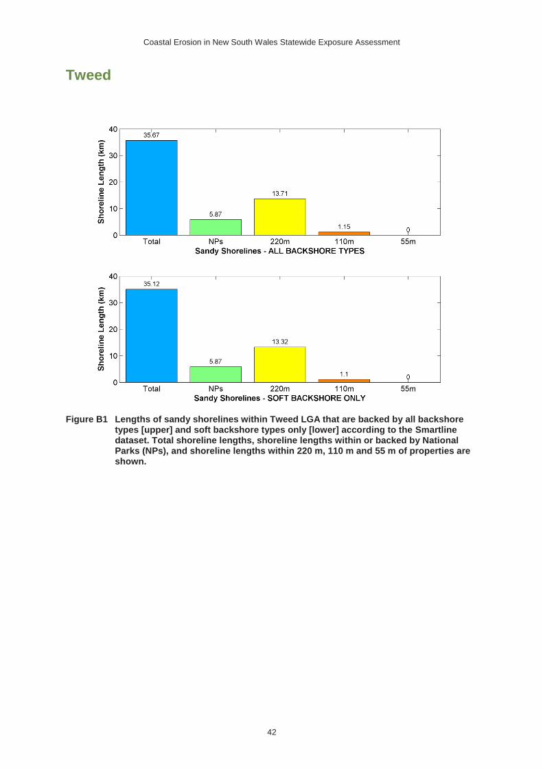
Coastal Erosion in New South Wales Statewide Exposure Assessment
42
Tweed
Figure B1 Lengths of sandy shorelines within Tweed LGA that are backed by all backshore types [upper] and soft backshore types only [lower] according to the Smartline dataset. Total shoreline lengths, shoreline lengths within or backed by National Parks (NPs), and shoreline lengths within 220 m, 110 m and 55 m of properties are shown.

Coastal Erosion in New South Wales Statewide Exposure Assessment
43
Figure B2 Map of Tweed LGA showing sandy shorelines that are located in close proximity to properties (55, 110, 220 m), and within or immediately backed by National Parks.

Coastal Erosion in New South Wales Statewide Exposure Assessment
44
The Smartline dataset was used to distinguish between sandy shorelines that are backed by soft and hard backshore substrate types.
Byron
Figure B3 Lengths of sandy shorelines within Byron LGA that are backed by all backshore types [upper] and soft backshore types only [lower] according to the Smartline dataset. Total shoreline lengths, shoreline lengths within or backed by National Parks (NPs), and shoreline lengths within 220 m, 110 m and 55 m of properties are shown.

Coastal Erosion in New South Wales Statewide Exposure Assessment
45
Figure B4 Map of Byron LGA showing sandy shorelines that are located in close proximity to properties (55, 110, 220 m), and within or immediately backed by National Parks. The Smartline dataset was used to distinguish between sandy shorelines that are backed by soft and hard backshore substrate types.

Coastal Erosion in New South Wales Statewide Exposure Assessment
46
Ballina
Figure B5 Lengths of sandy shorelines within Ballina LGA that are backed by all backshore types [upper] and soft backshore types only [lower] according to the Smartline dataset. Total shoreline lengths, shoreline lengths within or backed by National Parks (NPs), and shoreline lengths within 220 m, 110 m and 55 m of properties are shown.

Coastal Erosion in New South Wales Statewide Exposure Assessment
47
Figure B6: Map of Ballina LGA showing sandy shorelines that are located in close proximity to properties (55, 110, 220 m), and within or immediately backed by National Parks. The Smartline dataset was used to distinguish between sandy shorelines that are backed by soft and hard backshore substrate types.

Coastal Erosion in New South Wales Statewide Exposure Assessment
48
Richmond Valley
Figure B7 Lengths of sandy shorelines within Richmond Valley LGA that are backed by all backshore types [upper] and soft backshore types only [lower] according to the Smartline dataset. Total shoreline lengths, shoreline lengths within or backed by National Parks (NPs), and shoreline lengths within 220 m, 110 m and 55 m of properties are shown.

Coastal Erosion in New South Wales Statewide Exposure Assessment
49
Figure B8 Map of Richmond Valley LGA showing sandy shorelines that are located in close proximity to properties (55, 110, 220 m), and within or immediately backed by National Parks. The Smartline dataset was used to distinguish between sandy shorelines that are backed by soft and hard backshore substrate types.

Coastal Erosion in New South Wales Statewide Exposure Assessment
50
Clarence Valley
Figure B9 Lengths of sandy shorelines within Clarence Valley LGA that are backed by all backshore types [upper] and soft backshore types only [lower] according to the Smartline dataset. Total shoreline lengths, shoreline lengths within or backed by National Parks (NPs), and shoreline lengths within 220 m, 110 m and 55 m of properties are shown.

Coastal Erosion in New South Wales Statewide Exposure Assessment
51
Figure B10 Map of Clarence Valley LGA showing sandy shorelines that are located in close proximity to properties (55, 110, 220 m), and within or immediately backed by National Parks. The Smartline dataset was used to distinguish between sandy shorelines that are backed by soft and hard backshore substrate types.

Coastal Erosion in New South Wales Statewide Exposure Assessment
52
Coffs Harbour
Figure B11 Lengths of sandy shorelines within Coffs Harbour LGA that are backed by all backshore types [upper] and soft backshore types only [lower] according to the Smartline dataset. Total shoreline lengths, shoreline lengths within or backed by National Parks (NPs), and shoreline lengths within 220 m, 110 m and 55 m of properties are shown.

Coastal Erosion in New South Wales Statewide Exposure Assessment
53
Figure B12 Map of Coffs Harbour LGA showing sandy shorelines that are located in close proximity to properties (55, 110, 220 m), and within or immediately backed by National Parks. The Smartline dataset was used to distinguish between sandy shorelines that are backed by soft and hard backshore substrate types.

Coastal Erosion in New South Wales Statewide Exposure Assessment
54
Bellingen
Figure B13 Lengths of sandy shorelines within Bellingen LGA that are backed by all backshore types [upper] and soft backshore types only [lower] according to the Smartline dataset. Total shoreline lengths, shoreline lengths within or backed by National Parks (NPs), and shoreline lengths within 220 m, 110 m and 55 m of properties are shown.

Coastal Erosion in New South Wales Statewide Exposure Assessment
55
Figure B14 Map of Bellingen LGA showing sandy shorelines that are located in close proximity to properties (55, 110, 220 m), and within or immediately backed by National Parks. The Smartline dataset was used to distinguish between sandy shorelines that are backed by soft and hard backshore substrate types.

Coastal Erosion in New South Wales Statewide Exposure Assessment
56
Nambucca
Figure B15 Lengths of sandy shorelines within Nambucca LGA that are backed by all backshore types [upper] and soft backshore types only [lower] according to the Smartline dataset. Total shoreline lengths, shoreline lengths within or backed by National Parks (NPs), and shoreline lengths within 220 m, 110 m and 55 m of properties are shown.

Coastal Erosion in New South Wales Statewide Exposure Assessment
57
Figure B16 Map of Nambucca LGA showing sandy shorelines that are located in close proximity to properties (55, 110, 220 m), and within or immediately backed by National Parks. The Smartline dataset was used to distinguish between sandy shorelines that are backed by soft and hard backshore substrate types.

Coastal Erosion in New South Wales Statewide Exposure Assessment
58
Kempsey
Figure B17 Lengths of sandy shorelines within Kempsey LGA that are backed by all backshore types [upper] and soft backshore types only [lower] according to the Smartline dataset. Total shoreline lengths, shoreline lengths within or backed by National Parks (NPs), and shoreline lengths within 220 m, 110 m and 55 m of properties are shown.

Coastal Erosion in New South Wales Statewide Exposure Assessment
59
Figure B18 Map of Kempsey LGA showing sandy shorelines that are located in close proximity to properties (55, 110, 220 m), and within or immediately backed by National Parks. The Smartline dataset was used to distinguish between sandy shorelines that are backed by soft and hard backshore substrate types.

Coastal Erosion in New South Wales Statewide Exposure Assessment
60
Port Macquarie-Hastings
Figure B19 Lengths of sandy shorelines within Port Macquarie-Hastings LGA that are backed by all backshore types [upper] and soft backshore types only [lower] according to the Smartline dataset. Total shoreline lengths, shoreline lengths within or backed by National Parks (NPs), and shoreline lengths within 220 m, 110 m and 55 m of properties are shown.

Coastal Erosion in New South Wales Statewide Exposure Assessment
61
Figure B20 Map of Port Macquarie-Hastings LGA showing sandy shorelines located in close proximity to properties (55, 110, 220 m), and within or immediately backed by National Parks. The Smartline dataset was used to distinguish between sandy shorelines that are backed by soft and hard backshore substrate types.

Coastal Erosion in New South Wales Statewide Exposure Assessment
62
Mid-Coast (Greater Taree)
Figure B21 Lengths of sandy shorelines within Mid-Coast (Greater Taree) LGA that are backed by all backshore types [upper] and soft backshore types only [lower] according to the Smartline dataset. Total shoreline lengths, shoreline lengths within or backed by National Parks (NPs), and shoreline lengths within 220 m, 110 m and 55 m of properties are shown.

Coastal Erosion in New South Wales Statewide Exposure Assessment
63
Figure B22 Map of Mid-Coast (Greater Taree) LGA showing sandy shorelines that are located in close proximity to properties (55, 110, 220 m), and within or immediately backed by National Parks. The Smartline dataset was used to distinguish between sandy shorelines that are backed by soft and hard backshore substrate types.

Coastal Erosion in New South Wales Statewide Exposure Assessment
64
Mid-Coast (Great Lakes)
Figure B23 Lengths of sandy shorelines within Mid-Coast (Great Lakes) LGA that are backed by all backshore types [upper] and soft backshore types only [lower] according to the Smartline dataset. Total shoreline lengths, shoreline lengths within or backed by National Parks (NPs), and shoreline lengths within 220 m, 110 m and 55 m of properties are shown.

Coastal Erosion in New South Wales Statewide Exposure Assessment
65
Figure B24 Map of Mid-Coast (Great Lakes) LGA showing sandy shorelines that are located in close proximity to properties (55, 110, 220 m), and within or immediately backed by National Parks. The Smartline dataset was used to distinguish between sandy shorelines that are backed by soft and hard backshore substrate types.

Coastal Erosion in New South Wales Statewide Exposure Assessment
66
Port Stephens
Figure B25 Lengths of sandy shorelines within Port Stephens LGA that are backed by all backshore types [upper] and soft backshore types only [lower] according to the Smartline dataset. Total shoreline lengths, shoreline lengths within or backed by National Parks (NPs), and shoreline lengths within 220 m, 110 m and 55 m of properties are shown.

Coastal Erosion in New South Wales Statewide Exposure Assessment
67
Figure B26 Map of Port Stephens LGA showing sandy shorelines that are located in close proximity to properties (55, 110, 220 m), and within or immediately backed by National Parks. The Smartline dataset was used to distinguish between sandy shorelines that are backed by soft and hard backshore substrate types.

Coastal Erosion in New South Wales Statewide Exposure Assessment
68
Newcastle
Figure B27 Lengths of sandy shorelines within Newcastle LGA that are backed by all backshore types [upper] and soft backshore types only [lower] according to the Smartline dataset. Total shoreline lengths, shoreline lengths within or backed by National Parks (NPs), and shoreline lengths within 220 m, 110 m and 55 m of properties are shown.

Coastal Erosion in New South Wales Statewide Exposure Assessment
69
Figure B28 Map of Newcastle LGA showing sandy shorelines that are located in close proximity to properties (55, 110, 220 m), and within or immediately backed by National Parks. The Smartline dataset was used to distinguish between sandy shorelines that are backed by soft and hard backshore substrate types.

Coastal Erosion in New South Wales Statewide Exposure Assessment
70
Lake Macquarie
Figure B29 Lengths of sandy shorelines within Lake Macquarie LGA that are backed by all backshore types [upper] and soft backshore types only [lower] according to the Smartline dataset. Total shoreline lengths, shoreline lengths within or backed by National Parks (NPs), and shoreline lengths within 220 m, 110 m and 55 m of properties are shown.

Coastal Erosion in New South Wales Statewide Exposure Assessment
71
Figure B30 Map of Lake Macquarie LGA showing sandy shorelines that are located in close proximity to properties (55, 110, 220 m), and within or immediately backed by National Parks. The Smartline dataset was used to distinguish between sandy shorelines that are backed by soft and hard backshore substrate types.

Coastal Erosion in New South Wales Statewide Exposure Assessment
72
Central Coast (Wyong)
Figure B31 Lengths of sandy shorelines within Central Coast (Wyong) LGA that are backed by all backshore types [upper] and soft backshore types only [lower] according to the Smartline dataset. Total shoreline lengths, shoreline lengths within or backed by National Parks (NPs), and shoreline lengths within 220 m, 110 m and 55 m of properties are shown.
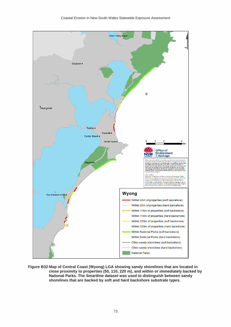
Coastal Erosion in New South Wales Statewide Exposure Assessment
73
Figure B32 Map of Central Coast (Wyong) LGA showing sandy shorelines that are located in close proximity to properties (55, 110, 220 m), and within or immediately backed by National Parks. The Smartline dataset was used to distinguish between sandy shorelines that are backed by soft and hard backshore substrate types.

Coastal Erosion in New South Wales Statewide Exposure Assessment
74
Central Coast (Gosford)
Figure B33 Lengths of sandy shorelines within Central Coast (Gosford) LGA that are backed by all backshore types [upper] and soft backshore types only [lower] according to the Smartline dataset. Total shoreline lengths, shoreline lengths within or backed by National Parks (NPs), and shoreline lengths within 220 m, 110 m and 55 m of properties are shown.

Coastal Erosion in New South Wales Statewide Exposure Assessment
75
Figure B34 Map of Central Coast (Gosford) LGA showing sandy shorelines that are located in close proximity to properties (55, 110, 220 m), and within or immediately backed by National Parks. The Smartline dataset was used to distinguish between sandy shorelines that are backed by soft and hard backshore substrate types.

Coastal Erosion in New South Wales Statewide Exposure Assessment
76
Northern Beaches (Pittwater)
Figure B35 Lengths of sandy shorelines within Northern Beaches (Pittwater) LGA that are backed by all backshore types [upper] and soft backshore types only [lower] according to the Smartline dataset. Total shoreline lengths, shoreline lengths within or backed by National Parks (NPs), and shoreline lengths within 220 m, 110 m and 55 m of properties are shown.

Coastal Erosion in New South Wales Statewide Exposure Assessment
77
Figure B36 Map of Northern Beaches (Pittwater) LGA showing sandy shorelines that are located in close proximity to properties (55, 110, 220 m), and within or immediately backed by National Parks. The Smartline dataset was used to distinguish between sandy shorelines that are backed by soft and hard backshore substrate types.

Coastal Erosion in New South Wales Statewide Exposure Assessment
78
Northern Beaches (Warringah)
Figure B37 Lengths of sandy shorelines within Northern Beaches (Warringah) LGA that are backed by all backshore types [upper] and soft backshore types only [lower] according to the Smartline dataset. Total shoreline lengths, shoreline lengths within or backed by National Parks (NPs), and shoreline lengths within 220 m, 110 m and 55 m of properties are shown.

Coastal Erosion in New South Wales Statewide Exposure Assessment
79
Figure B38 Map of Northern Beaches (Warringah) LGA showing sandy shorelines that are located in close proximity to properties (55, 110, 220 m), and within or immediately backed by National Parks. The Smartline dataset was used to distinguish between sandy shorelines that are backed by soft and hard backshore substrate types.

Coastal Erosion in New South Wales Statewide Exposure Assessment
80
Northern Beaches (Manly)
Figure B39 Lengths of sandy shorelines within Northern Beaches (Manly) LGA that are backed by all backshore types [upper] and soft backshore types only [lower] according to the Smartline dataset. Total shoreline lengths, shoreline lengths within or backed by National Parks (NPs), and shoreline lengths within 220 m, 110 m and 55 m of properties are shown.

Coastal Erosion in New South Wales Statewide Exposure Assessment
81
Figure B40 Map of Northern Beaches (Manly) LGA showing sandy shorelines that are located in close proximity to properties (55, 110, 220 m), and within or immediately backed by National Parks. The Smartline dataset was used to distinguish between sandy shorelines that are backed by soft and hard backshore substrate types.

Coastal Erosion in New South Wales Statewide Exposure Assessment
82
Woollahra
Figure B41 Lengths of sandy shorelines within Woollahra LGA that are backed by all backshore types [upper] and soft backshore types only [lower] according to the Smartline dataset. Total shoreline lengths, shoreline lengths within or backed by National Parks (NPs), and shoreline lengths within 220 m, 110 m and 55 m of properties are shown.

Coastal Erosion in New South Wales Statewide Exposure Assessment
83
Figure B42 Map of Woollahra LGA showing sandy shorelines that are located in close proximity to properties (55, 110, 220 m), and within or immediately backed by National Parks. The Smartline dataset was used to distinguish between sandy shorelines that are backed by soft and hard backshore substrate types.
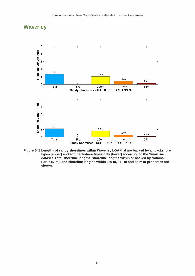
Coastal Erosion in New South Wales Statewide Exposure Assessment
84
Waverley
Figure B43 Lengths of sandy shorelines within Waverley LGA that are backed by all backshore types [upper] and soft backshore types only [lower] according to the Smartline dataset. Total shoreline lengths, shoreline lengths within or backed by National Parks (NPs), and shoreline lengths within 220 m, 110 m and 55 m of properties are shown.

Coastal Erosion in New South Wales Statewide Exposure Assessment
85
Figure B44 Map of Waverley LGA showing sandy shorelines that are located in close proximity to properties (55, 110, 220 m), and within or immediately backed by National Parks. The Smartline dataset was used to distinguish between sandy shorelines that are backed by soft and hard backshore substrate types.

Coastal Erosion in New South Wales Statewide Exposure Assessment
86
Randwick
Figure B45 Lengths of sandy shorelines within Randwick LGA that are backed by all backshore types [upper] and soft backshore types only [lower] according to the Smartline dataset. Total shoreline lengths, shoreline lengths within or backed by National Parks (NPs), and shoreline lengths within 220 m, 110 m and 55 m of properties are shown.

Coastal Erosion in New South Wales Statewide Exposure Assessment
87
Figure B46 Map of Randwick LGA showing sandy shorelines that are located in close proximity to properties (55, 110, 220 m), and within or immediately backed by National Parks. The Smartline dataset was used to distinguish between sandy shorelines that are backed by soft and hard backshore substrate types.

Coastal Erosion in New South Wales Statewide Exposure Assessment
88
Bayside (Botany Bay)
Figure B47 Lengths of sandy shorelines within Bayside (Botany Bay) LGA that are backed by all backshore types [upper] and soft backshore types only [lower] according to the Smartline dataset. Total shoreline lengths, shoreline lengths within or backed by National Parks (NPs), and shoreline lengths within 220 m, 110 m and 55 m of properties are shown.

Coastal Erosion in New South Wales Statewide Exposure Assessment
89
Figure B48 Map of Bayside (Botany Bay) LGA showing sandy shorelines that are located in close proximity to properties (55, 110, 220 m), and within or immediately backed by National Parks. The Smartline dataset was used to distinguish between sandy shorelines that are backed by soft and hard backshore substrate types.

Coastal Erosion in New South Wales Statewide Exposure Assessment
90
Bayside (Rockdale)
Figure B49 Lengths of sandy shorelines within Bayside (Rockdale) LGA that are backed by all backshore types [upper] and soft backshore types only [lower] according to the Smartline dataset. Total shoreline lengths, shoreline lengths within or backed by National Parks (NPs), and shoreline lengths within 220 m, 110 m and 55 m of properties are shown.

Coastal Erosion in New South Wales Statewide Exposure Assessment
91
Figure B50 Map of Bayside (Rockdale) LGA showing sandy shorelines that are located in close proximity to properties (55, 110, 220 m), and within or immediately backed by National Parks. The Smartline dataset was used to distinguish between sandy shorelines that are backed by soft and hard backshore substrate types.

Coastal Erosion in New South Wales Statewide Exposure Assessment
92
Sutherland
Figure B51 Lengths of sandy shorelines within Sutherland LGA that are backed by all backshore types [upper] and soft backshore types only [lower] according to the Smartline dataset. Total shoreline lengths, shoreline lengths within or backed by National Parks (NPs), and shoreline lengths within 220 m, 110 m and 55 m of properties are shown.

Coastal Erosion in New South Wales Statewide Exposure Assessment
93
Figure B52 Map of Sutherland LGA showing sandy shorelines that are located in close proximity to properties (55, 110, 220 m), and within or immediately backed by National Parks. The Smartline dataset was used to distinguish between sandy shorelines that are backed by soft and hard backshore substrate types.

Coastal Erosion in New South Wales Statewide Exposure Assessment
94
Wollongong
Figure B53 Lengths of sandy shorelines within Wollongong LGA that are backed by all backshore types [upper] and soft backshore types only [lower] according to the Smartline dataset. Total shoreline lengths, shoreline lengths within or backed by National Parks (NPs), and shoreline lengths within 220 m, 110 m and 55 m of properties are shown.

Coastal Erosion in New South Wales Statewide Exposure Assessment
95
Figure B54 Map of Wollongong LGA showing sandy shorelines that are located in close proximity to properties (55, 110, 220 m), and within or immediately backed by National Parks. The Smartline dataset was used to distinguish between sandy shorelines that are backed by soft and hard backshore substrate types.

Coastal Erosion in New South Wales Statewide Exposure Assessment
96
Shellharbour
Figure B55 Lengths of sandy shorelines within Shellharbour LGA that are backed by all backshore types [upper] and soft backshore types only [lower] according to the Smartline dataset. Total shoreline lengths, shoreline lengths within or backed by National Parks (NPs), and shoreline lengths within 220 m, 110 m and 55 m of properties are shown.

Coastal Erosion in New South Wales Statewide Exposure Assessment
97
Figure B56 Map of Shellharbour LGA showing sandy shorelines that are located in close proximity to properties (55, 110, 220 m), and within or immediately backed by National Parks. The Smartline dataset was used to distinguish between sandy shorelines that are backed by soft and hard backshore substrate types.

Coastal Erosion in New South Wales Statewide Exposure Assessment
98
Kiama
Figure B57 Lengths of sandy shorelines within Kiama LGA that are backed by all backshore types [upper] and soft backshore types only [lower] according to the Smartline dataset. Total shoreline lengths, shoreline lengths within or backed by National Parks (NPs), and shoreline lengths within 220 m, 110 m and 55 m of properties are shown.

Coastal Erosion in New South Wales Statewide Exposure Assessment
99
Figure B58 Map of Kiama LGA showing sandy shorelines that are located in close proximity to properties (55, 110, 220 m), and within or immediately backed by National Parks. The Smartline dataset was used to distinguish between sandy shorelines that are backed by soft and hard backshore substrate types.

Coastal Erosion in New South Wales Statewide Exposure Assessment
100
Shoalhaven
Figure B59 Lengths of sandy shorelines within Shoalhaven LGA that are backed by all backshore types [upper] and soft backshore types only [lower] according to the Smartline dataset. Total shoreline lengths, shoreline lengths within or backed by National Parks (NPs), and shoreline lengths within 220 m, 110 m and 55 m of properties are shown.

Coastal Erosion in New South Wales Statewide Exposure Assessment
101
Figure B60 Map of Shoalhaven LGA (north) showing sandy shorelines located in close proximity to properties (55, 110, 220 m), and within or immediately backed by National Parks. The Smartline dataset was used to distinguish between sandy shorelines that are backed by soft and hard backshore substrate types.

Coastal Erosion in New South Wales Statewide Exposure Assessment
102
Figure B61 Map of Shoalhaven LGA (south) showing sandy shorelines located in close proximity to properties (55, 110, 220 m), and within or immediately backed by National Parks. The Smartline dataset was used to distinguish between sandy shorelines that are backed by soft and hard backshore substrate types.

Coastal Erosion in New South Wales Statewide Exposure Assessment
103
Eurobodalla
Figure B62 Lengths of sandy shorelines within Eurobodalla LGA that are backed by all backshore types [upper] and soft backshore types only [lower] according to the Smartline dataset. Total shoreline lengths, shoreline lengths within or backed by National Parks (NPs), and shoreline lengths within 220 m, 110 m and 55 m of properties are shown.

Coastal Erosion in New South Wales Statewide Exposure Assessment
104
Figure B63 Map of Eurobodalla LGA (north) showing sandy shorelines located in close proximity to properties (55, 110, 220 m), and within or immediately backed by National Parks. The Smartline dataset was used to distinguish between sandy shorelines that are backed by soft and hard backshore substrate types.

Coastal Erosion in New South Wales Statewide Exposure Assessment
105
Figure B64 Map of Eurobodalla LGA (south) showing sandy shorelines located in close proximity to properties (55, 110, 220 m), and within or immediately backed by National Parks. The Smartline dataset was used to distinguish between sandy shorelines that are backed by soft and hard backshore substrate types.

Coastal Erosion in New South Wales Statewide Exposure Assessment
106
Bega Valley
Figure B65 Lengths of sandy shorelines within Bega Valley LGA that are backed by all backshore types [upper] and soft backshore types only [lower] according to the Smartline dataset. Total shoreline lengths, shoreline lengths within or backed by National Parks (NPs), and shoreline lengths within 220 m, 110 m and 55 m of properties are shown.

Coastal Erosion in New South Wales Statewide Exposure Assessment
107
Figure B66 Map of Bega Valley LGA (north) showing sandy shorelines located in close proximity to properties (55, 110, 220 m), and within or immediately backed by National Parks. The Smartline dataset was used to distinguish between sandy shorelines that are backed by soft and hard backshore substrate types.

Coastal Erosion in New South Wales Statewide Exposure Assessment
108
Figure B67 Map of Bega Valley LGA (south) showing sandy shorelines located in close proximity to properties (55, 110, 220 m), and within or immediately backed by National Parks. The Smartline dataset was used to distinguish between sandy shorelines that are backed by soft and hard backshore substrate types.