Embed Size (px)
Citation preview
COAL FIELDS OF THE DANFORTH HILLS AND GRAND HOGBACK IN NORTHWESTERN COLORADO."
Bv HOYT S. GALE.
LOCATION".
The coal fields of the Danforth Hills and the Grand Hogback are situated in the northwestern part of Colorado, in the counties of Routt, Rio Blanco, and Garfield. The territory here described is only a part of a much larger field, the Colorado portion of which has hitherto been frequently referred to as the Grand River coal field.
The Danforth Hills field lies north of White River, west of the White River plateau, south of Axial Basin, and east/)f the valley of Strawberry Creek and its extension toward the north. This valley is fixed as the western limit to the coal field because the coal-bearing strata dipping in that direction pass beneath it to so great a depth that they can not be considered as workable beyond this line. The Grand Hogback is a long monoclinal ridge lying mainly between Grand and White rivers, containing a relatively narrow belt of the outcropping coal strata which forms the southern extension of the Danforth Hills field. It crosses White River near Meeker, Rio Blanco County, extends due south from this point for about 20 miles, and then southeast for a similar distance, crossing Grand River at the town of Newcastle.
A westward extension from the Danforth Hills coal field north of White River lies along the southern flanks of the Yampa Plateau, or Blue Mountain, as it is locally known, reaching across the State line into Utah, beyond which comparatively little is known of the district as a coal field.
ACCESSIBILITY.
The valley of Grand River is at present the principal route by which travel and comme'rce reach northwestern and western Colorado from the east. It is now the route of the only railroads in Colorado
o The present paper is a preliminary report of an investigation conducted in the summer of 1906. The members of the 'field party were Arthur K. Adams, Albert L. Beekly, Ralph D. Crawford, and the writer. A more complete report containing a detailed contoured map of the coal fields will be published later as a bulletin of the United States Geological Survey.
264
COAL OP DANFOKTH HILLS AND GRAND HOGBACK, COLO. 265
approaching the coal fields here described. A projected line of the Denver, Northwestern and Pacific Railway passes through Routt County, and is now (spring, 1907) in process of construction from Middle Park by way of Gore Canyon across to the Yampa Valley, with apparently every likelihood of completion in the near future, at least as far as Steamboat Springs. This road, if constructed down Yampa River, will open up a large coal field. A great part of the Danforth Hills and lower White River coal fields will, however, even then be almost as. far removed from routes of transportation as they are at present from the railroads on Grand River. The only com mercial developments of any considerable extent lying within the field of this report are those at Newcastle and east and southeast of that point, all of which are reached by branch lines from the railroads on Grand River. Among these producing localities may be men tioned the Newcastle, South Canyon, Black Diamond, Pocahontas. Midland, Sunlight, Spring Gulch, and Coalbasin mines.
STRATIGRAPHY.
AGE OF COAL-BEARING ROCKS.
The coal beds occur in a series of sandstones and sandy shales that were mapped by the geologists of the Hayden Survey as the combined Fox Hills and Laramie groups of the Cretaceous. In the reports of the early investigators statements are made to the effect that no definite distinction can be made between the strata of these two formations and that the limits of the groups of strata as then defined were purely arbitrary and were made for the purpose of applying a classification adapted to other fields. The investigations in the Yampa coal field in 1905 a led to the conclusion that the subdivisions previously made could not be applied to the sequence of rock forma tions that occur in that field, and names proposed by Whitman Cross b for a similar sequence of Cretaceous beds in the San Juan Mountains region were adopted. These are as follows:
Upper Cretaceous...
Laramie formation. Lewis shale. Mesaverde formation. Mancos shale. Dakota sandstone.
South of the anticlinal axis which separates the Yampa basin from the Danforth Hills coal field the sequence of formations including the coal-bearing rocks apparently does not correspond to that of the Yampa field. While two distinct coal-bearing formations, the Laramie and the Mesaverde, are present in the Yampa field, separated
"Fenneman, N. M., and Gale, H. S., The Yampa coal field, Routt County, Colo.: Bull. U. S. Geol. Survey No. 297,1906.
» Description of the La Plata district: Geologic Atlas U. S., folio 60, U. S. Geol. Survey, 1899.
266 CONTRIBUTIONS TO ECONOMIC GEOLOGY, 1906, PART Il7
by a thick body of shale, there appears to be but a single series of strata containing coal beds in the southern field, and the evidence at hand points strongly to the equivalence in age of this single series with the older of the coal-bearing formations developed farther north. There can be but little question that the base of the coal-bearing strata in the Danforth Hills field and the base of the Mesaverde formation in the Tampa field are of equivalent geologic age, a conclu sion based on the evidence of the fossils which these strata contain and the almost unmistakable structural relations as shown in Axial Basin, where the coal-bearing strata of the two fields are separated by an interval of only 3 or 4 miles across an anticlinal valley.
The question as to what constitutes the Laramie formation has long been a source of doubt and dispute. As stated above, the geol ogists of the Hayden Survey mapped the upper part of the strata of the Danforth Hills and Grand Hogback as of Laramie age. A few fossils were collected during the present investigation that seem to corroborate this earlier determination, as based on the definitions that were then accepted of the Laramie formation. The fact remains, however, that the coal-bearing rocks in the Danforth Hills and Grand Hogback are, for all practical purposes, a stratigraphic and lithologic unit without any recognized break or unconformity.
THE COAL-BEARING ROCKS.
The coal-bearing strata of the fields here discussed are distinct in character from both the overlying and underlying formations. They are massive ledge-making sandstones, together with thinner-bedded sandstones and sandy shales and coal beds. This group of strata usually forms ridges or mountains because the sandstone members offer relatively greater resistance to erosion than either the overlying or underlying shale. The coal-bearing rocks attain a thickness of approximately a mile.
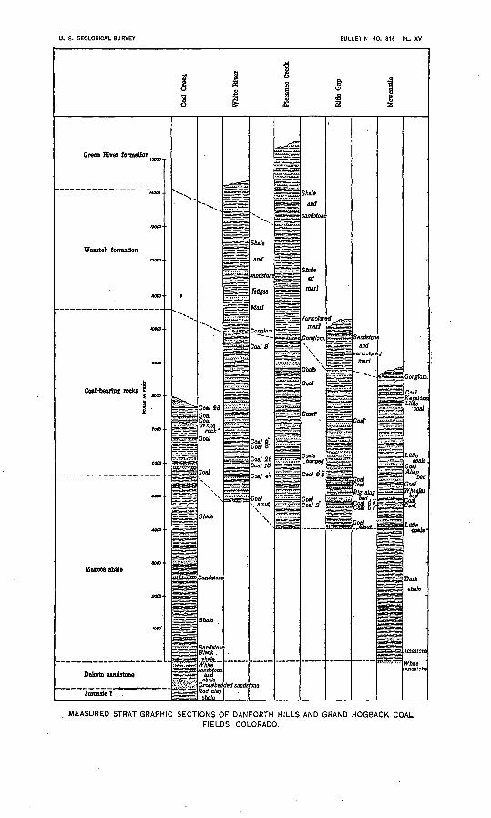
Details of the stratigraphic sections vary from place to place, as do also the thickness and quality of individual coal beds, but a few general characteristics are found to persist in or dominate certain horizons, although all the minor characteristics vary greatly in detail. These features are illustrated in a set of measured stratigraphic sections taken in various parts of the field (PI. XV).
The base of the coal-bearing rocks is in general sharply defined by the lowest conspicuous sandstone ledge, but in places there is a tran sition from the prevailing sandy rocks above into shaly strata below. In the present mapping the base of the coal-bearing group of rocks is drawn at the. horizon of the lowest sandstone in the main escarp ment that characterizes the outcrop of these beds where they face the valley formed upon the underlying shale. The scattering beds of sandstone that occur below the main escarpment show as minor, and
m
o
3 I
m <
/>
COAL OF DANFORTH HILLS AND GRAND HOGBACK, COLO. 267
separate ridges within the valley area. A good example of one of these outlying ridges extends northeastward from Meeker, lying parallel to the principal escarpment front.
The lower 800 to 1,500 feet of these sandstones and shales is more prominent as a ridge maker than the upper members of the coal- bearing strata; but in most localities the majority of the principal coal beds are grouped immediately above that horizon. In the vicinity of Axial Basin the base of the principal group of coal beds is marked by a massive white sandstone which may be readily traced in outcrop along the ridges as a conspicuous white ledge. This is locally referred to as the "white rock" and is apparently a very per sistent stratum around a large part of the Danforth Hills.
Coal beds almost invariably show above the "white rock," either as weathered streaks of carbonaceous material or more generally as bands of reddened and baked rock or slag, where the coal has been burned. Higher in the series the coal beds are scattered irregularly, and they vary from place to place so that individual sections show great variations in the number and grouping of the coal beds. The massive sandstone ledges are by far the most conspicuous features, in many places masking by their debris the intervening strata that are composed of weaker rocks.
The coal-bearing rocks appear to merge into the shale or marl of the supposed Wasatch beds above. Scattering sandstone beds occur among the varicolored beds of clay or marl overlying the coals, and many of these are so similar to the coal-bearing rocks as to be indis tinguishable from them. There is, however, a very persistent bed of coarse conglomerate or loose bowlders near the top of the coal- bearing strata and below the varicolored beds of the supposed Wasatch, which probably marks an unconformity in the beds an erosional time break during the deposition of the sediments. The conglomerate is therefore assumed to mark the boundary between the tw6 forma tions, or, in fact, between Cretaceous and Tertiary strata.
The accompanying table is a summary of the probable correlation, measured thicknesses, description, and topographic expression of the groups of strata which occur in or immediately adjacent to the coal field, arranged in the order of their geologic age.
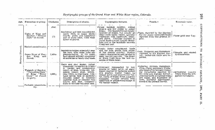
Stratigrapkic groups of the Grand River and White River region, Colorado.
Age.
Tertiary (Eocene).
Formation or group.
Uinta of King and Hayden; "Browns Park" of Powell.
Marked unconformity.
Green River of Hay- den, King, and Poweli.
Wasatch of Haydon; " Vermillion Creek" of King; ' ' Bitter Creek" of Powell (in part) .
Probable unconform ity.
Thickness.
Feet.
(?)
2,400+
4,000±
Description of strata.
Sandstone and less consolidated sandy beds, in many places coarse: gritty and calcareous and of white color, with some layers of gravel.
Sandstone ledges, especially near the base, with shale intervals predominating. In its upper part almost entirely composed of dense fine or sandy clay shale.
Clays and clay shales, rather commonly variegated in bright ly banded and conspicuous colors, as pink, brick-red, ver milion, yellow, drab, brown clear white, or coal-black. Con tains pebble beds of perfectly rounded jasper or siliceous material such as colored vein quartz and flint. Conglom erate or bowlder bed near base.
Topographic features.
Forms sandhill country, rolling prairie and low ridges or minor peaks. The sandstones are locally exposed as ledges, but usually as clear-white sandy banks, sparsely vegetated with sagebrush, cedar, and pinon. Typically exposed in Axial Basin around Juniper Moun tain and in the sandhills between Craig and Lay.
Usually forms escarpment bluffs and the long, gentle back slopes of the plateau country. Stream valleys characteristically eroded in deep, narrow canyons. The Roan or Book Cliffs form the best ex ample of these rocks.
Universally represented by low prairie or valley lands, at many places scarred by badlands washes and gulches. Cactus Valley, on Grand River, and Strawberry Val ley, north of White River, are good examples. Usually covered with sagebrush or greasewood except in the barren washes.
Fossils, a
Physa, reported by the Hayden Survey: .many vertebrate bones reported from this general re gion.
TJnio, Viviparus, and Goniobasis reported by the Hayden Sur vey; vertebrate bones also re ported.
Viviparus, Melania, Goniobasis, Unio, Physa pleromatis White; also bones of vertebrates includ ing Coryphodon reported by the King and Hayden Survey; crocodile tooth of Tertiary type, fish scales, and fragments of bone, probably mammalian, found in the present survey.
Economic value.
Placer gold near Lay.
Gilsonite and related hydrocarbons.
Agricultural lands where water for irri gation is available.
toO5 00
3O
103
I o
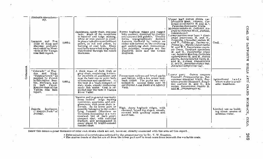
Probable unconform ity.
Laramie and Fox Hills of King and Hay den; probably equivalent to Mesa- verde of the Yampa coal field report.
"Colorado" of Hay-den and King; "Sulphur Creek" as mapped by Powell in this region: Ben- ton, Niobrara, and in part Pierre; Mancos shale of the Yampa coal fieldreport.
Dakota sandstone ("Henrys Fork" of Powell).
5,000±
5,000±
Sandstone, sandy shale, and coal beds. Much of the sandstone is massive and ledge making, white or iron stained in color, in places baked to morebrilliant colors, as red and yellow, by burning of coal beds. Many coal beds somewhat irregularly distributed through the entire thickness.
A thick mass of dark drab orgray shale, containing lenticu lar members of sandstone and near its base one or more beds of limestone and sandstone. At the base is a black compact or slaty shale, usually containing many fish scales. Coal is re ported near the base in YampaRiver Valley.
Massive and in general markedlycross -bedded ledge -makingsandstone, quartzite, and conglomerate, with some shale intervals. In its lower part or possibly belonging to the under lying Jurassic ("Morrison or GuTinison formation) is a veryconstant bed of dark -greencompact clay, with cuboidalfracture, also accompanied inmany places by bright-coloredbanded shale.
Forms hogback ridges and rugged hilly country, dissected by sharply cut canyons and gulches. Usually forms topographically distinct features bordered by valleys on either side formed on the overlying and underlying shale formations. The principal examples are the Danforth Hills and the Grand Hogback.
Forms open valleys and broad parks and basins, with a few minor hog back ridges. The parks are very extensive; among them may be mentioned Axial Basin and Agency Park. '
High, sharp hogback ridges, with elevated, broad dip slopes, usually covered with quaking aspen and scrub 'oak.
Upper half: Ostrea glabra var.arcuatilis Meek, A-nomia, Cor-bicula occidentalis M. and H.?,Tulotoma thompsoni White.
Horizon indefinite: Callista? . <An-omiamicronema Meek, Modiola, Odontobasis?.
Lower portion near base: & Goni- omya americana M. and H., Liopistha ( Cymella) undata M. and H., Tellina sp., Lucina sp., Pinna sp., Mytilus subarcuatus M. and H.?, Inoceramus sagen- sis Owen, Cardium speciosum M. and H., Inoceramus cripsi var. barabini Morton, Corbiculacylheriformis M. and H., Oslreaglabra, .Syncyclonema rigida H.and M., Avicula linguxformisE. and S., Baculites ovatus Say,13 acuities compressus Say.
Lower part: Ostrea congesta Conrad?, Prionoci/clus sp., Ino ceramus dimidius White, Kac- ulites gracilis Shumard, Scaph- ites warreni M. and H., fish scales, Inoceramus fragilis H. and M., Prionotropis sp.
Coal. .
Agricultural lands where water is avail able; limestone.
Limited use as build ing stone; source of artesian water.
CO
Below this occurs a great thickness of older rock strata which are not, however, directly concerned with the area of this report..
i Determination of invertebrates collected by the present survey by Dr. T. W. Stanton.6 The marine fossils of this list are all from the lower part and in most cases-from beneath the workable coals.
270 CONTRIBUTIONS TO ECONOMIC GEOLOGY, 1906, PART II.
STRTJCTTJBE.
UINTA AND GREEN RIVER BASINS,
The coal fields of northwestern Colorado are contained in two broad structural basins or depressions of the rock strata, surrounded by areas of older rocks which are relatively uplifted. The northern of these two is the Green River Basin, the greater part of which lies in Wyoming, but which extends into Colorado to the headwaters of Yampa River. The Uinta Basin is separated from the Green River Basin by the Uinta Mountain anticlinal axis, which reaches eastward through Axial Basin into the White River plateau and the western spurs of the Rocky Mountain system. The Uinta Basin lies south of the Uinta Mountains, extends to the Rocky Mountains and their foothills on the east, and is terminated on the south by the uplifts of the La Sal Mountains and the San Rafael Swell. It extends west ward to the Wasatch Range in Utah. The Uinta Basin in Colorado includes an area of approximately 7,000 square miles.
These two basins outline the dominant geologic structure of nearly the whole of northwestern Colorado. They are in the form of broad synclinal folds or troughs, narrowing to an apex toward the south east. Within this State their longer axes are approximately parallel, extending from southeast to northwest. The coal-bearing rocks outcrop in practically continuous rims around the borders of the basins where they have not been buried by later formations, and the strata dip toward the interior of the basins, probably extending to great depths beneath the younger and overlying deposits. Thus the coal fields actually available are limited for the most part to the terri tory adjacent to the outcropping coal beds.
That part of the eastern rim of the Uinta Basin which was exam ined during the past year extends from the Danforth Hills southward to Grand River. In the Danforth Hills the exposure of the coal-bear ing beds is broad, for their outcrop is repeated by minor folds. South of the Danforth Hills the coal strata extend in a narrow outcrop of steeply inclined beds known as the Grand Hogback from White River to Grand River, a distance of 43 miles. South of Grand River the Grand Hogback continues in a southeasterly and southerly direc tion, disappearing as a monoclinal ridge in the high and rugged dis trict of the West Elk Mountains. Coal croppings may be followed with some brief interruptions southward from the vicinity of Glen- wood Springs on Grand River across the main divide to the tributary valleys of Gunnison River. Near the well-known anthracite locality at Crested Butte the strata lie nearly horizontal, forming the extreme southeastern apex along the longer axis of the Uinta Basin.
COAL OF DANFORTH HILLS AND GRAND HOGBACK, COLO.
MINOR FOLDS OF THE COAL-FIELD STRATA.
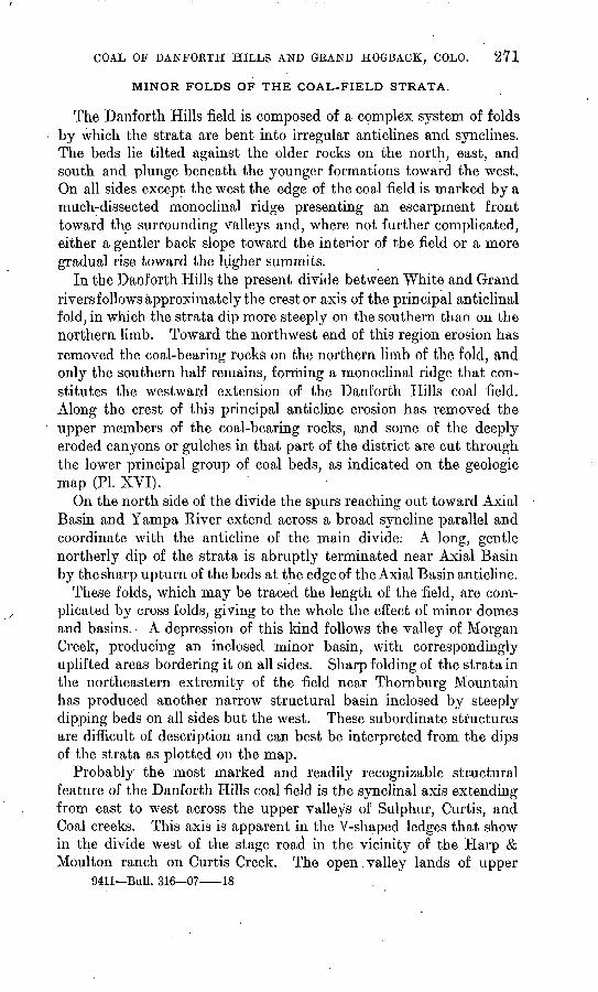
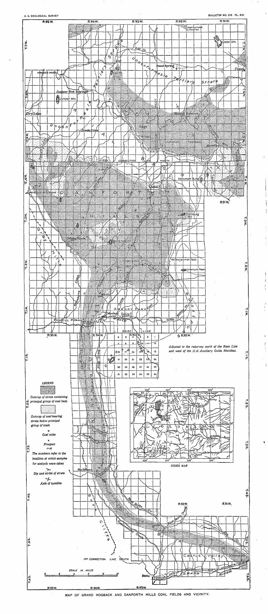
The Danforth Hills field is composed of a complex system of folds by which the strata are bent into irregular anticlines and synclines. The beds lie tilted against the older rocks on the north, east, and south and plunge beneath the younger formations toward the west. On all sides except the west the edge of the coal field is marked by a much-dissected monoclinal ridge presenting an escarpment front toward the surrounding valleys and, where not further complicated, either a gentler back slope toward the interior of the field or a more gradual rise toward the higher summits.
In the Danforth Hills the present divide between White and Grand rivers follows approximately the crest or axis of the principal anticlinal fold, in which the strata dip more steeply on the southern than on the northern limb. Toward the northwest end of this region erosion has removed the coal-bearing rocks on the northern limb of the fold, and only the southern half remains, forming a monoclinal ridge that con stitutes the westward extension of the Danforth Hills coal field. Along the crest of this principal anticline erosion has removed the upper members of the coal-bearing rocks, and some of the deeply eroded canyons or gulches in that part of the district are cut through the lower principal group of coal beds, as indicated on the geologic map (PI. XVI).
On the north side of the divide the spurs reaching out toward Axial Basin and Yampa River extend across a broad syncline parallel and coordinate with the anticline of the main divide: A long, gentle northerly dip of the strata is abruptly terminated near Axial Basin by the sharp upturn of the beds at the edge of the Axial Basin anticline.
These folds, which may be traced the length of the field, are com plicated by cross folds, giving to the whole the effect of minor domes and basins. A depression of this kind follows the valley of Morgan Creek, producing an inclosed minor basin, with correspondingly uplifted areas bordering it on all sides. Sharp folding of the strata in the northeastern extremity of the field near Thornburg Mountain has produced another narrow structural basin inclosed by steeply dipping beds on all sides but the west. These subordinate structures are difficult of description and can best be interpreted from the dips of the strata as plotted on the map.
Probably the most marked and readily recognizable structural feature of the Danforth Hills coal field is the synclinal axis extending from east to west across the upper valleys of Sulphur, Curtis, and Coal creeks. This axis is apparent in the V-shaped ledges that show in the divide west of the stage road in the vicinity of the Harp & Moulton ranch on Curtis Creek. The open valley lands of upper
9411 Bull. 316 07 18
272 CONTKIBUTIONS TO ECONOMIC GEOLOGY, 1906, PAET II.
Sulphur and Curtis creeks and the Ninemile Draw are eroded from the weaker shaly strata that outcrop along the axis of this syncline. Farther east the fold crosses Coal Creek and terminates at the south east end of the Danforth Hills field. To the west the two limbs of the Sulphur Creek syncline spread sharply at Strawberry Valley, the northern limb forming the western border of the Danforth Hills field, the southern limb continuing across White River as a monocline, already described as the Grand Hogback ridge.
FAULTS.
The structure of this region is affected only in a very subordinate way by faults. In the absence of readily distinguishable beds or horizon markers among the coal-bearing strata, and by reason of the similarity of the various members of this group of strata, minor slips or dislocations within the field may easily have been overlooked. Although some suggestions of possible faults were noted during the progress of the field work, in but a single case did the evidence seem clear enough to. be unquestionable. In that case, however, the fault did not appear to affect the coal field, occurring west of it and influencing only the Tertiary rocks north of the Keystone ranch. Many minor slips of the beds near the surface are encoun tered in prospecting or mining the coal, but these are too local to be recognized as structural features, and too small to be shown on the map.
COAL.
AREAL EXTENT OF THE COAL FIELDS.
As explained in the descriptions of the great structural basins,. the coal fields that are likely to prove commercially valuable are limited very closely to the areas of actual outcrops of the coal- bearing rocks, for the dips of the strata toward the centers of the basins are generally steep, and in most parts they doubtless carry the coal beds to great depths a short distance back from the outcrop. Such conditions prevail especially along the eastern margin of the Uinta Basin, which is here described as the Danforth Hills and Grand Hogback coal fields.
The area of the Danforth Hills is very nearly 300 square miles and this may be considered as practically the extent of that coal field. As has been stated, the lower thousand feet or so of the coal- bearing group of sandstones and shales do not usually contain valu able coals, and the recognized outcrop of these rocks is distinguished by a separate pattern on the geologic map (PI. XVI). However, as these lower strata are known to contain some coal, they may properly be considered as a part of the coal field.
U. S. GEOLOGICAL SURVEY BULLETIN NO. 316 PL. XVI
Adjusted to the resurvey north of the Base Line and west of the 11 th Auxiliary Guide Meridian.
Outcrop of strata containing \«/) principal group of coal beds
Outcrop of coal-bearing strata below principal group of coals
The numbers refer to the localities at which samples
for analysis were taken
1ST. CORRECTION LINE SOUTH
MAP OF GRAND HOGBACK AND DANFORTH HILLS COAL FIELDS AND VICINITY.
U. S. GEOLOGICAL SURVEY
Winter Quarter
Base of coal-bearing rocks
Location of faillt£
Approximate location of faults
X Coat prospects
Boundary of forest reserve
The mapping of coal lend was conducted by stadis measurements "d with c/ose conformity to land surveys.
MAP OF
PLEASANT VALLEY DISTRICT, UTAH
SHOWING BASE OF
COAL-BEARING ROCKS.
COAL OF DANFORTH HILLS AND GKAND HOGBACK, COLO. . 273
The Grand Hogback coal field is limited to a narrow belt between White and Grand rivers which includes an area of probably not much more than 75 square miles.
THICKNESS AND NUMBER OF COAL BEDS.
As explained under the heading " Stratigraphy " (p. 266), the group of rock strata that contains the coal is approximately a mile in
.thickness, and many beds of valuable coal are found in one position or another within this mass. Both the toiM number and the thick ness of the individual beds vary from place to place along the outcrop, as may be observed in the thickening or pinching out of the beds where they can be traced. In only two localities is anything like a complete measurement of the coals now obtainable. One of these, at Newcastle, on Grand River, is particularly favorable for the measurement of what is supposed to be the maximum thickness of coal beds, as it contains the thickest single coal known in the whole field. The other, on White River below Meeker, may be taken as representative of the stratigraphic section of the field in its total quantity of coal, which is somewhat less than that of the Newcastle section. Similar sections are exposed at other localities in the various stream gaps along the Grand Hogback, but the lack of development makes it impossible at the present time to measure the coals.
The section across the Grand Hogback at Newcastle is probably the most completely prospected in the field. Some mines of con siderable extent have been operated at this place under the manage ment of the Colorado Fuel and Iron Company. The measurements given for the coals of this locality are taken from the statements of the chief engineer of that company,0 for all but one of the mines are now abandoned and wholly inaccessible. The locality as a mining camp is known to be dangerous, as much trouble has been experienced with explosive dust and gas and spontaneous combustion of the coal. Mines on all the large beds on the north side of Grand River have been abandoned on account of fire, which up to the present time has proved entirely beyond control. The following is a statement of the thickness of the different coal beds at Newcastle:
Thickness of coal beds at Newcastle.
Feet. "C seam"....... ............'.... 5" Anderson seam''............... 8"Alien seam" ................... 20' : D seam" ...................... 5"Wheeler seam "................ 45-48
Feet. "E seam"..................... 18"F seam" ..................... 4
Total workable coal...... 105-108
."Hose'a, R. M., The Newcastle mines, Colorado: Colliery Engineer, vol. 17,1897, pp. 377-382, 425-429.
274 CONTEIBUTIONS TO ECONOMIC GEOLOGY, 1906, PAET II.
The thickness of the stratigraphic intervals separating these beds is shown on PI. XV (p. 266). The Wheeler coaUis^ approximately 1,000 feet from the base of the formation, and the Alien is approx imately 1,000 feet above the Wheeler. The only coal now worked on the north side of Grand River is a bed known as the Keystone, which is somewhat higher than any in the section detailed above, and which is only 22 to 24 inches thick. The Keystone bed is 4,000 feet stratigraphically above the base of the formation, and with the exception of two smaller beds, is the highest known coal bed. The beds of the Newcastle section dip southwestward at angles ranging from 50° at the base of the formation to 25° at the Keystone mine.
Coal in the section across the Grand Hogback on White River below Meeker has been developed mainly to supply the small demand for domestic use in that vicinity. The beds dip to the west at angles ranging from 31° to 68°, and most of the thicker coals are exposed by a series of prospects along the north side of White River. The following coals were accessible when visited and were measured in the present investigation:
Thickness of coal beds exposed on White River below Meeker.Ft. in.
Lion Canyon, upper entry................................. 5 8Lion Canyon, W. B. Blythe coal mine. ...............^...... 8 5A. H. Adams mine, 3 benches, not including bone............ 8 5Old Meeker bea, A. H. Adams property...................... 5 10F. W. Fairfield property, west entry......................... G 3F. W. Fairfield property, middle entry, upper bench......... 9 8F. W. Fairfield property, middle entry, lower bench.......... 9 +F. W. Fairfield property, east entry (old Major bank)......... 13 +Mrs. Grace H. Adams property, prospect..................... 3 3Mrs. Grace H. Adams property, mine......................... 4 1
73 7
Without doubt a considerable number of workable coals that are not included in the foregoing list occur in the White River section. It is therefore safe to assume a minimum thickness of 75 feet as representing the workable coal of this section.
Though all the coal-bearing strata may be found in regular sequence in a small portion of the field where the beds are so steeply tilted as to bring the uppermost down to water level (a condition fulfilled for the most part only along the western margin of the field), the remain ing and greater part of the coal field is underlain only by the lower members of the formation, the upper strata having been worn away. Synclines and basins generally retain a larger number of coal beds below water level than regions uplifted and dissected by canyons or broader valleys. The geologic map shows several areas within the Danforth Hills, from which it seems clear that nearly all the valuable coals have been removed.
COAL OP DANFOBTH HILLS AND GRAND HOGBACK, COLO. 275
Fortunately-for the economic development of the Danforth Hills field, the principal coal beds occur low in the formation and many of the important coal beds remain where even a great thickness of strata has been removed. Thus many of the thick coal beds outcrop at the surface along the ridges and gulches in the interior of the. field, and by reason of their light dips may prove readily accessible for devel opment.
The best-known examples of thick coals in these localities are two beds that have been opened on Spring Creek Gulch near and. south of AxiaJ post-office. These measure 25 and 27 feet of excellent coal, a total of over 50 feet exposed, with indications of a considerable number of other workable beds near by.
DETAILED DESCRIPTIONS.
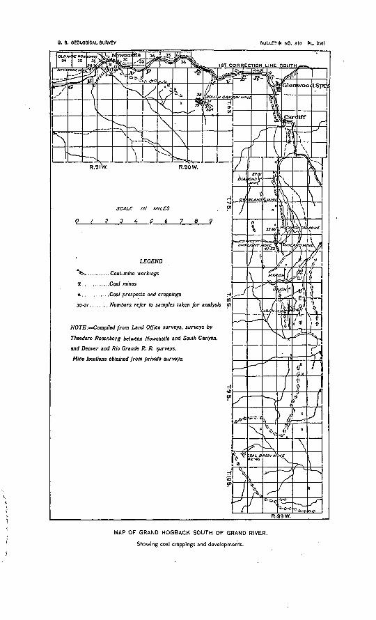
A systematic review of all the localities examined or measured will be included in a report of this investigation to be published later. It has been found necessary to limit the descriptions in this prelimi nary report to a brief mention of the more important properties. These are treated in the order in which they were examined in the field, the numbers indicating the mine and prospect localities on the maps (Pis. XVI, p. 272, and XVII, p. 290).
Nos. 2-4, Lay, Routt County. The localities numbered 2, 3, and 4 are in a group of coal entries situated about a mile south to south east of Lay post-office, in Routt County. These coal properties are in the west end of the Yampa coal field and are described in the report on that field,* although they were not sampled during the field work of that investigation. One of these properties was sam pled by R. C. Hills, and the analysis published in 1893.6 The fol lowing measurements were made where the samples were obtained:
Section of the W-foot coal bed at Lay (No. 2).
Ft. in. Coal without partings.......................................... 9 9Shale, carbonaceous........................................... 1 3Coal, apparently free from partings (lower 5 feet 7 inches sampled) . 10 6
Shale, carbonaceous. ' 21 6
Section of the Peacock coal bed at Lay (No. 3).Ft. in.
Coal left as roof, thickness reported............................. 1 6Coal, mined.................................................... 5 2Coal, bony, pyritiferous........................................ 4Coal, mined.................................................... 2
9
a Bull. U. S. Gcol. Survey No. 297,1906, p. 63.bCoal fields of Colorado; Mineral Resources U. S. for 1892, U. S. Geological Survey, 1893, p. 365.
276 CONTRIBUTIONS TO ECONOMIC GEOLOGY, 1906, PART II. '
Section of the Sweeney coal bed at Lay (No. 4).Shale. Ft. in.
Clay, white, kaolin-like ........................................ 1 ±Coal.... .... .....'............................................ 3 10Bone......................................................... 1Coal ... ..........:..................................:. ........ 4*Bone.......................................................... 1 7Coal, thickness reported, not measured........................... 4
15 5
No. 5. Collom mine, Axial. Routt County. The Collom mine, on Spring Creek, 1£ miles south of Axial post-office, is probably the best-known coal bank in the northern part of the Danforth Hills. The coal bed is very thick, measuring, as nearly as could be deter mined, 24 feet 5£ inches, with a single half-inch bony seam 16 feet 3 inches from the base. The coal lies nearly flat, dipping lightly to the south and east, and is an exceptionally solid, bright, black shiny coal. It breaks with an irregular conchoidal fracture, and is clean to handle, being apparently very free from smut or dust. It shows an excellent analysis as compared with other coals of this part of the field and an exceptionally low amount of ash. The following is a section measured at the mouth of the mine:
Section at Collom mine near Axial (No. 5).
Shale. Ft. in. Coal...........................................:.............. 8 6Shale or bone................................................ $Coal.......................................................... 16 3
Shale.................................................... 3 +
Total coal bed........................................... 24 9£
The Collom bed is several hundred feet stratigraphically above that of the W. H. Miller bank (No. 16 of this list), but a close esti mate of this interval could not be obtained. The mine has been worked in a broad, high entry, so that wagons from neighboring ranches are loaded at the face, the teams being driven in and turned around in the mine.
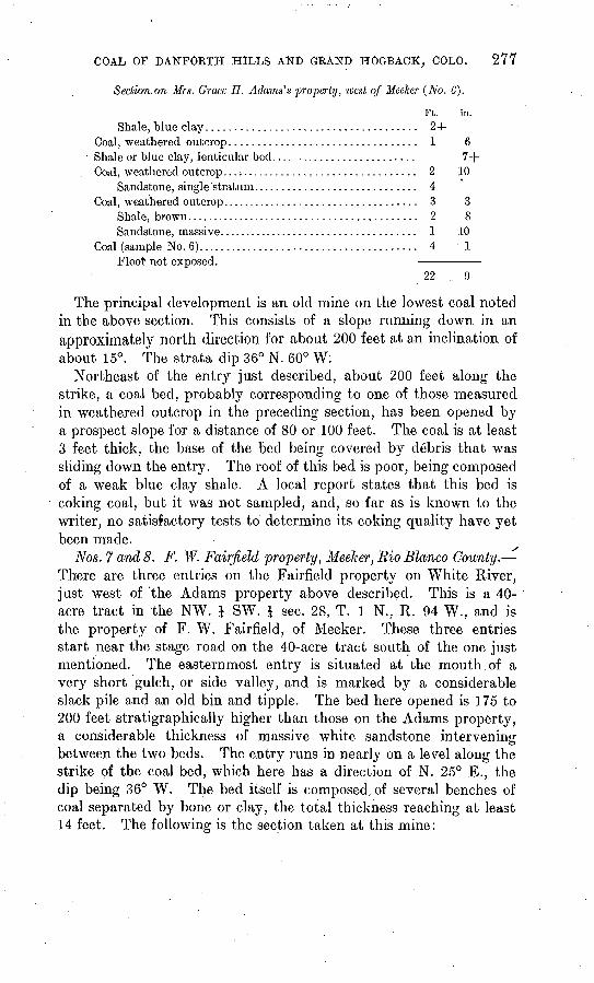
No. 6. Mrs. G. H. Adams property. Meeker, Rio Blanco County. The first entry on the public road west of Meeker is in the NE. \ SW. \ sec. 28, T. 1 N., R. 94 W., and is the property of Mrs. Grace H. Adams. Entries have been made on two of the lowest workable beds that have been recognized in this region. The following section was measured at this place.
COAL OP DANFORTH HILLS AND GRAND HOGBACK, COLO. 277
Section.on Mrs. Grace H. Adams's property, west of Meeker (No. 6).
Ft. in.Shale, blue clay..................................... 2+
Coal, weathered outcrop................................. 1 6Shale or blue clay, lenticular bed.......................... 7+Coal, weathered outcrop.................................... 2 10
Sandstone, single'stratum............................. 4Coal, weathered outcrop................................... 3 3
Shale, brown.......................................... 2 8Sandstone, massive.................................... 1 10
Coal (sample No. 6)....................................... 4 1Floor not exposed.
22 9
The principal development is an old mine on the lowest coal noted in the above section. This consists of a slope running down, in an approximately north direction for about 200 feet at an inclination of about 15°. The strata dip 36° N. 60° W:
Northeast of the entry just described, about 200 feet along the strike, a coal bed, probably corresponding to one of those measured in weathered outcrop in the preceding section, has been opened by a prospect slope for a distance of 80 or 100 feet. The coal is at least 3 feet thick, the base of the bed being covered by debris that was sliding down the entry. The roof of this bed is poor, being composed of a weak blue clay shale. A local report states that this bed is coking coal, but it was not sampled, and, so far as is known to the writer, no satisfactory tests to determine its coking quality have yet been made.
^
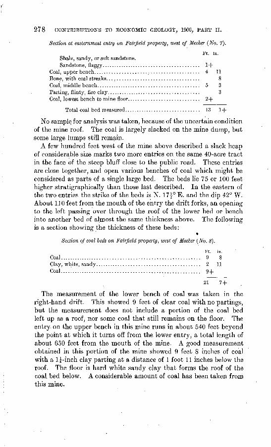
Nos. 7 and 8. F. W. Fairfield property, Meeker, Rio Blanco County. There are three entries on the Fairfield property on White River, just west of the Adams property above described. This is a 40- acre tract in the NW. J SW. | sec. 28, T. 1 N., R. 94 W., and is the property of F. W. Fairfield, of Meeker. These three entries start near the stage road on the 40-acre tract south of the one just mentioned. The easternmost entry is situated at the mouth of a very short gulch, or side valley, and is marked by a considerable slack pile and an old bin and tipple. The bed here opened is 175 to 200 feet stratigraphically higher than those on the Adams property, a considerable thickness of massive white sandstone intervening between the two beds. The entry runs in nearly on a level along the strike of the coal bed, which here has a direction of N. 25° E., the dip being 36° W. The bed itself is composed, of several benches of coal separated by bone or clay, the total thickness reaching at least 14 feet. The following is the section taken at this mine:
278 CONTRIBUTIONS TO ECONOMIC GEOLOGY, 1906, PART II.
Section at easternmost entry on Fair field property, west of Meeker (No. 7).
Ft. in. Shale, sandy, or soft sandstone.Sandstone, flaggy....................................... 1+
Coal, upper bench......................................... 4 11Bone, with coal streaks.................................... 8Coal, middle bench......................................... 5 3Parting, flinty, fire clay..................................... 3Coal, lowest bench to mine floor............................ 2+
Total coal bed measured.............................. 13 1+
No sample for analysis was taken, because of the uncertain condition of the mine roof. The coal is largely slacked on the mine dump, but some large lumps still remain.
A few hundred feet west of the mine above described a slack heap of considerable size marks two more entries on the same 40-acre tract in the face of the steep bluff close to the public road. These entries are close together, and open various benches of coal which might be considered as parts of a single large bed. The beds lie 75 or 100 feet higher stratigraphically than those last described. In the eastern of the two entries the strike of the beds is N. 17£° E. and the dip 42° W. About 110 feet from the mouth of the entry the drift forks, an opening to the left passing over through the roof of the lower bed or bench into another bed of almost the same thickness above. The followingis a section showing the thickness of these beds:
«Section of coal beds on Fairfield property, west of Meeker (No. 8).
Ft. in. Coal....................................................... 9 8Clay, white, sandy......................................... 2 11Coal....!.................................................. 9+
21 7 +
The measurement of the lower bench of coal was taken in the right-hand drift. This showed 9 feet of clear coal with no partings, but the measurement does not include a portion of the coal bed left up as a roof, nor some coal that still remains on the floor. The entry on the upper bench in this mine runs in about 540 feet beyond the point at which it turns off from the lower entry, a total length of about 650 feet from the mouth of the mine. A good measurement obtained in this portion of the mine showed 9 feet 8 inches of coal with a l|-inch clay parting at a distance of 1 foot 11 inches below the roof. The floor is hard white sandy clay that forms the roof of the coal bed below. A considerable amount of coal has been taken from this mine.
COAL OF DANFORTB HILLS AND GRAND HOGBACK, COLO.
The mine next to the west is on a coal bed close above the double bed just described, the entrance being about 100 feet farther west. This drift runs in 430 feet along the strike of the coal bed, which is recorded as N. 20° E. at this point, the dip being 37° W. The coal is 6 feet 3 inches thick, with a coal floor which could not be measured. The roof is sandstone. Three inches of coal at the top of the bed is much slickensided and the coal is much jointed across the bedding.
A local report states that coal beds aggregating 50 feet in thickness have been opened on this property, but this statement could not be verified at the time of visit, although it is undoubtedly true that several thick beds do occur.
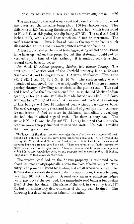
No. 9. A. H. Adams property, Meeker, Rio Blanco County. The next group of entries west of the Fairfield property is on a 40-acre tract of coal land belonging to A. H. Adams, of Meeker. This is the SE. 1 SE. 1 sec. 29, T. 1 N., R. 94 W. The eastern entry is now abandoned and caved, but it was originally worked from an entrance passing through a dwelling house close to the public road. This coal bed is said to be the first one opened for use at the old Meeker Indian agency, although a similar claim is made for" the so-called "old Gov ernment bank" oil Coal Creek. A measurement made at the outcrop of this bed gave 5 feet 10 inches of coal without partings or bone. The coal was apparently clean and hard and of good quality. A mass ive sandstone 15 feet or more in thickness, immediately overlying the bed, should afford a good roof. The floor is bony coal. The strike is N. 8° E. and the dip 42° W. It may be noted that the strata become more steeply inclined toward the west. Mr. Adams makes the following statement:
The longest of the three tunnels penetrates the coal a'distance of about 325 feet. About 5,300 cubic yards of coal have been mined from this bed. An analysis of the coal by Mr. Noble showed 53 per cent fixed carbon. It is of uniform thickness and shows no bone or slate and very little ash. There are no important beds between my property and the Lion Canyon mine. There are several smaller ones, the largest of which I have any knowledge being on my property and measuring about 28 inches, lying about 175 feet above the west bed.
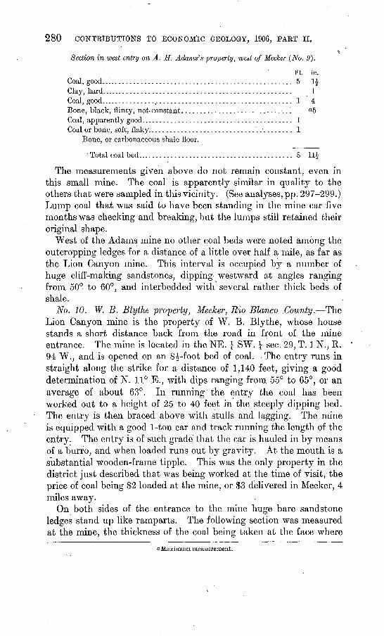
The western coal bed on the Adams property is estimated to be about 130 feet stratigraphically above the '.'old Meeker seam." This entry is at present marked by a whim and small wooden-frame tipple. It runs down a short slope and ends in a small room, the whole being less than 100 feet in length. Several very massive sandstone ledges .occur just above the coal bed, the immediate roof being a few inches (3±) of blue clay shale. The strike of the rock in the entry is N. 17° E., but no satisfactory determination of the dip was obtained. The following is a detailed section taken in the mine.
280 CONTKlBUTIOttS TO ECONOMIC GEOLOGY, 1906, PAET II.
Section in west entry on A. TI. Adams's property, west of Meeker (No. 9).
Ft. in. Coal, good.................................................... 5 1£Clay, hard.................................................... 1Coal, good..................................................... 1 4Bone, black, flinty, not-constant.............................. °5Coal, apparently good......................................... 1Coal or bone, soft, flaky....................................... 1
Bone, or carbonaceous shale floor.
Total coal bed.......................................... 8 11$
The measurements given above do not remain constant, even in this small mine. The coal is apparently similar in quality to the others that were sampled in this vicinity. (See analyses, pp. 297-299.) Lump coal that was said to have been standing in the mine car five months was checking and breaking, but the lumps still retained their original shape.
West of the Adams mine no other coal beds were noted among the outcropping ledges for a distance of a little over half a mile, as far as the Lion Canyon mine. This interval is occupied by a number of huge cliff-making sandstones, dipping westward at angles ranging from 50° to 60°, and interbedded with several rather thick beds of shale.
No. 10. W. B. Ely the property, Meeker, Rio Blanco .County. The Lion Canyon mine is the property of W. B. Ely the, whose house stands a short distance back from the road in front of the mine entrance. The mine is located in the NE. ^ SW. i sec. 29, T. 1 N., K. 94 W., and is opened on an S^-foot bed of coal. The entry runs in straight along the strike for a distance of 1,140 feet, giving a good determination of N. 11° E., with dips ranging from 55° to 65°, or an average of about 63°. In running the entry the coal has been worked out to a height of 25 to 40 feet in the steeply dipping bed. The entry is then braced above with stulls and lagging. The mine is equipped with a good 1-ton car and track running the length of the entry. The entry is of such grade that the car is hauled in by means of a burro, and when loaded runs out by gravity. At the mouth is a substantial wooden-frame tipple. This was the only property in the district just described that was being worked at the time of visit, the price of coal being $2 loaded at the mine, or S3 delivered in Meeker, 4 miles away.
On both sides of the entrance to the mine huge bare sandstone ledges stand up like ramparts. The following section was measured at the mine, the thickness of the coal being taken at the face where
a Maximum measurement.
COAL OF DANFOKTH HILLS AND GRAND HOGBACK, COLO. 281
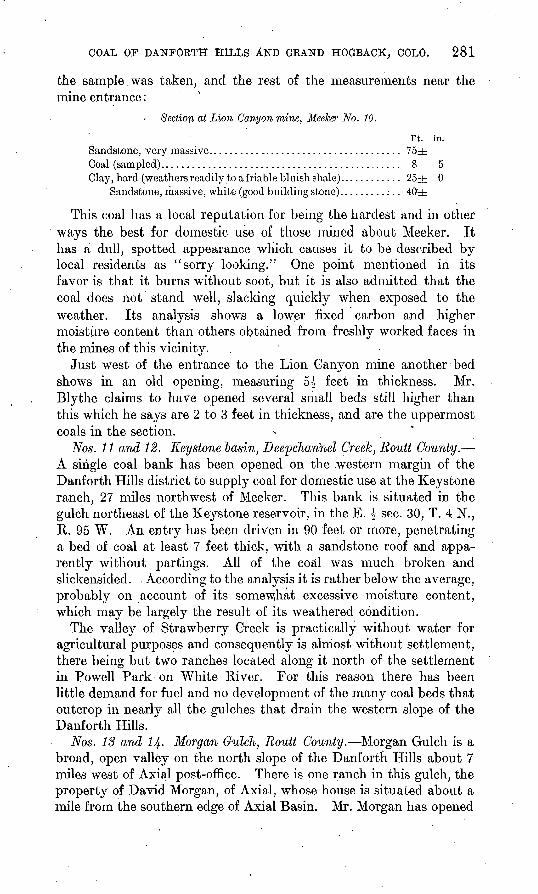
the sample was taken, and the rest of the measurements near the mine entrance:
Section at Lion Canyon mine. Meeker No. JO.
Ft. in. Sandstone, very massive....................................... 75+Coal (sampled).............................................. 8 5Clay, hard (weathers readily to a friable bluish shale)............ 25+ 0
Sandstone, massive, white (good building stone).........:.. 40±
This coal has a local reputation for being the hardest and in other ways the best for domestic use of those mined about Meeker. It has a dull, spotted appearance which causes it to be described by local residents as "sorry looking." One point mentioned in its favor is that it burns without soot, but it is also admitted that the coal does not stand well, slacking quickly when exposed to the weather. Its analysis shows a lower fixed carbon and higher moisture content than others obtained from freshly worked faces in the mines of this vicinity.
Just west of the entrance to the Lion Canyon mine another bed shows in an old opening, measuring 5^ feet in thickness. Mr. Blythe claims to have opened several small beds still higher than this which he says are 2 to 3 feet in thickness, and are the uppermost coals in the section.
Nos. 11 and 12. Keystone basin, Deepcharinel Creek, Routt County. A single coal bank has been opened on the .western margin of the Danforth Hills district to supply coal for domestic use at the Keystone ranch, 27 miles northwest of Meeker. This bank is situated in the gulch northeast of the Keystone reservoir, in the E. £ sec. 30, T. 4 N., R. 95 W. An entry has been driven in 90 feet or more, penetrating a bed of coal at least 7 feet thick, with a sandstone roof and appa rently without partings. All of the coal was much broken and slickensided. According to the analysis it is rather below the average, probably on account of its somew.hat excessive moisture content, which may be largely the result of its weathered condition.
The valley of Strawberry Greek is practically without water for agricultural purposes and consequently is almost without settlement, there being but two ranches located along it north of the settlement in Powell Park on White River. For this reason there has been little demand for fuel and no development of the many coal beds that outcrop in nearly all the gulches that drain the western slope of the Danforth Hills.
Nos. 13 and 14- Morgan Gulch, Routt County. Morgan Gulch is a broad, open valley on the north slope of the Danforth Hills about 7 miles west of Axial post-office. There is one ranch in this gulch, the property of David Morgan, of Axial, whose house is situated about a mile from the southern edge of Axial Basin. Mr. Morgan has opened
SB 2 CONTRIBUTIONS TO ECONOMIC GEOLOGY, JL906, PAftT II,
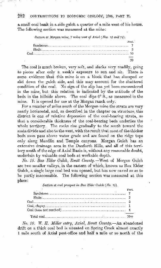
a small coal bank in a side gulch a quarter of a mile west of his house, The following section was measured at the mine:
Section at Morgan mine, 7 miles west of Axial (Nos. IS arid 14}.Feet.'
Sandstone................................................... 7Shale........................................................ 3
Coal.............................................................. 10
20
The coal is much broken, very soft, and slacks very readily, going to pieces after only a. week's exposure to sun and air. There is some evidence that this mine is on a block that has. slumped or slid down the gulch side, and this may account for the shattered condition of the coal. No sign of the slip has yet been encountered in the mine, but this relation is indicated by the attitude of the beds in the hillside above. The coal dips 6° S., as measured in the mine. It is opened for use at the Morgan ranch only.
For a number of miles south of the Morgan mine the strata are very nearly horizontal, and, as described in the chapter on structure, this district is one of relative depression of the coal-bearing strata, so that a considerable thickness of the coal-bearing beds underlies the whole territory. The rocks rise gradually to the south toward the main divide and also to the west, with the result that most of the thicker beds soon pass above water grade and are found on the ridge tops only along Maudlin and Temple canyons. Morgan Gulch has an extensive drainage area in the Danforth Plills, and all of this terri tory south of the edge of Axial Basin is, without any reasonable doubt, underlain by valuable coal beds at workable depth.
No. 15. Box Elder Gulch, Routt County. West of Morgan Gulch are two smaller valleys, in the eastern of which, known as Box Elder Gulch, a single large coal bed was opened, but has now caved so as to be partly inaccessible. The following section was measured at this place:
Section at coal prospect in Box Elder Gulch (No. 15}.Feet.
Sandstone................................................. 7Shale...................................................... 2
Coal............................................................ 5Coal, clayey................................................... 1Coal (base not reached).......................................... 4
Total coal..................................................... 10+
No. 16. W. H. Miller entry, Axial, Routt County. An abandoned drift on a thick coal bed is situated on Spring Creek almost exactly 1 mile south of Axial post-office and half a mile or so north of the
COAL OF DANFORTH HILLS AND GRAND HOGBACK, COLO. 283
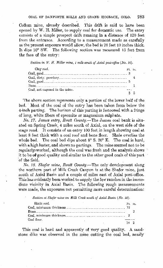
Collom mine, already described. This drift is said to have been opened by W. H. Miller, to supply coal for domestic use. The entry consists of a simple prospect drift running in a distance of 120 feet from the entrance. According to a measurement made as carefully as the present exposure would allow, the bed is 26 feet 10 inches thick. It dips 10° SW. The following section was measured 15 feet from the face of the entry:
Section in W. H. Miller mine, 1 mile south of Axial post-office (No. 16).
Clay roof. Ft. in. Coal, good...................................................... 3 Coal, dirty, powdery............................................ 4Coal, good...................................................... 5Bone........................................................... 1Coal, not exposed in the mine. '
8 5
The above section represents only a portion of the lower half of the bed. Most of the coal of the entry has been taken from below the 4-inch parting. The horizon of this parting is festooned with a fringe of long, white fibers of epsomite or magnesium sulphate.
No. 17. James entry, Routt County. The James coal bank is situ ated on Spring Creek, 4 miles south of Axial, on the west side of the stage road. It consists of an entry 100 feet, in length showing coal at least 8 feet thick with a coal roof and bone floor. Shale overlies the whole bed. The coal bed dips about 8° S. 20° E. The coal is hard, with a high luster, and shows no partings. The mine seemed not to be regularlycworked, although the coal was fresh and the analysis shows it to be-@f good quality and similar to the other good coals of this part of the field.
No. 18. SJiafer mine, Routt County. The only development along the northern part of Milk Creek Canyon is at the Shafer mine, just south of Axial Basin and a couple of miles east of Axial post-office. This has evidently been worked to supply the f QW ranches in the imme diate vicinity in Axial Basin. The following rough measurements were made, the exposures not permitting more careful determination:
Section at Shafer mine on Milk Creek south of Axial Basin (No. 18).
Shale roof. . Ft. in. Coal, minimum thickness....................................... 12Bone.......................................................... 2Coal, minimum thickness....................................... 2Coal floor.
14 2
This coal is hard and apparently of very good quality. A sand stone dike was observed in the mine cutting the coal bed, nearly
284 CONTRIBUTIONS TO ECONOMIC GEOLOGY, 1906, PAET II.
perpendicular to the bedding. Similar dikes were also noted in the Coryell mine on Grand River. A sample representing the upper 7 feet 6 inches of the bed was taken within 6 feet of the face of the mine. The entry runs down a slope on the dip for 25 feet, and a drift then swings to the left at a lighter pitch, turning up grade slightly in the last 25 feet of a total length of about 125 feet. This bed is probably about 100 feet above the " white rock/' with another heavy sandstone stratum some 50 feet above the coal. Another coal bed is prospected in a small tributary gulch north of the mine, its position being strati- graphically between the Shafer bed and the " white rock."
There has been much' burning of coal along the outcrops in the vicinity of the Shafer mine and above the "white rock," and there are doubtless a number of other valuable coal beds in this locality. A few small coals were noted occurring stratigraphically below the "white rock." Many outcrops of coal and much baked rock indi cating the presence of other beds are to be seen along the valley of Milk Creek through its entire course between the Shafer and Wilson entries, but at no place are any of these beds known to have been opened so as to show the value of the coals.
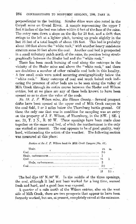
No. 19. J. F. Wilson mine, Rio Blanco County. Several prospect drifts have been opened at the upper end of Milk Creek canyon in the coal field, 2 or 3 miles below the Thornburg battle ground. Of these the only one that was in condition for sampling was an entry on the property of J. F. Wilson, of Thornburg, in the NW. | SE. \ sec. 29, T. 3 N., R. 92 W. Three openings have been made close together on the same coal bed, of which the northernmost is the only one worked at present. The coal appears to be of good quality, very hard, withstanding the action of the weather. The following section was measured at this place:
Section at the J. F. Wilson bank in Milk Creek Canyon (No. 19}.
Shale. Ft. in.Coal..................°..................................... 2+Shale, carbonaceous....................................... 1Coal....................................................... 11 1
Shale, carbonaceous................................... 2Coal....................................................... 2+
18 1+ -
The bed dips 15° N. 80° W. In the middle of the three openings, the coal, although it had not' been worked for a long time, seemed fresh and hard, and a good face-was exposed.
A quarter of a mile north of the Wilson entries, also on the west side of Milk Creek, there are two prospects that appear to have been formerly worked, but are, at present, completely caved at the entrance.
COAL OF DANFORTH HILLS AND GRAND HOGBACK; COLO. 285
The following measurements were made, but this section is very incomplete:
Section in Milk Creek canyon, one-fourth mile north of the Wilson mine.
Shale. Ft. in. Coal............................................................ 1Shale, carbonaceous........................................... 10Coal, at least.................................................. 5
6 10
The coal bed dips 5° N. 80° W. The second of the two entries opened a coal about 30 feet lower, but was totally inaccessible. Both of these beds are several hundred feet higher in the series than the Wilson bed. The latter is roughly'400 or 500 feet above the "white rock."
No. 20. Coal Creek, Rio Blanco County. On the west side of Coal Creek, in sec. 30, T. 2 N., R. 92 W., almost directly opposite the '/Transfer/' Gilbert Wesson has opened a prospect drift showing a fine bed of bright, hard coal over 25 feet thick. The prospect is on Government land which is withdrawn from entry pending the com pletion of the resurveys.' Nearly the whole thickness of the bed is exposed at the mouth of the entry, but the height of the coal and the timbering of the entry made a good measurement of the bed impracticable.. The coal bed dips N. 75° W. at an angle of about 22°. The entry is situated structurally at the flattened nose of a westwardrpitching synclinal trough, the end of that described on page 271 as the Sulphur Creek syncline. Outcropping coal beds at or near this horizon extend southward and, crossing a narrow spur or ridge, are again prospected in the banks of Ninemile Draw. This bed and those closely associated with it extend toward the north in outcrop along the ridge face approximately parallel to the public road beyond Yellow Jacket Pass, and may be the same coal as that opened just north of the pass and also at the Wilson mine in Milk Creek Canyon.
At the entrance to the Wesson mine an ash bed indicates that the lower part of the bed has been partially burned, but this burning extends in only a few feet. The present entry starts in near the middle of the bed, leaving much coal above and below as both roof and floor. The following is a section measured.at the face of the mine, but includes only a portion of the total thickness of the bed:
Section in Wesson mine, Coal Creek (No. 20).Ft. in.
Coal roof. ...................................................... (?)Coal, good...................................................... 3Coal, dirty seam.........:....................................... 2Coal, good...................................................... 1 6Coal, dirty searn................................................. 2Coal, good..........................................,,.,.,..'.... 4 3Coal floor.
9 1
286 CONTRIBUTIONS TO ECONOMIC GEOLOGY, 1906, PART II.
By a measurement of the whole stratigraphic section exposed near the locality of the "Transfer" (see PL XV, p. 266), the Wesson bed is estimated to be 2,000 feet above the base of the coal-bearing rocks. Here, as at many other points throughout the field, the "white rock/' a prominent massive white sandstone ledge, occurs in the coal-bearing rocks just below the principal group of workable coal beds. The Wesson coal bed lies about 500 feet, stratigraphically, above this ledge. Below* the ledge several indications of coal were noted, one bed hav ing been prospected to a depth of 60 feet or more, but, as elsewhere in this basal portion, the coal appears to be of comparatively little value. Above the white sandstone ledge at least two other beds are exposed below the Wesson bed, and possibly others may be obscured along the debris-filled bottom of Coal Creek.
Above the Wesson mine the canyon wall rises steeply to a height of 600 or 700 feet and the rocks are fairly well exposed. A few sandstones outcrop, but these are not prominent as ledge makers, showing chiefly where they have been hardened by the burning of coal beds. In such places they form cliffs of brecciated rock of bright- vermilion to brick-red color, interspersed with patches of unaltered white sandstone. These ledges are usually much broken up, being jointed both parallel to and across the bedding. As elsewhere noted, the coal beds rarely show in outcrop, having been almost universally burned, and leaving only slag, cinders, and reddened rock at the surface of the ground. Coal Creek appears to be an exceptionally favorable locality for the commercial development of the thick coal beds that undoubtedly occur at that place. These coals dip west ward, with flattening pitch, and almost certainly underlie at work able depth a large territory extending along the axis of the Sulphur Creek syncline. An. advantage of the Coal Creek locality as a point of access to this structural basin lies in the fact that the beds here have more moderate and uniform pitch in the direction of the syn clinal axis than anywhere along the sides of the basin.
Nos. 21 and 22. Sulphur Creek, Meeker, Rio Blanco County. A working mine and several prospect entries are situated in the valley of Sulphur Creek about 4 miles north of Meeker, in the NE. J NE. J sec. 10 and in the SW. J sec. 3, T. 1 N., R. 94 W. These are reported to be the property of T. D. Riley and Arthur Burnham, both of Meeker. The mines are on the P. P. Harp ranch. There are, in all, four entries, two on each side of the gulch. The two southernmost are apparently of the same or nearly the same horizon, opening coals on opposite sides of the valley. The bed at the principal mine is at least 7 feet thick, and the following section was measured '470 feet from the entrance:
COAL OF DANFORTH HILLS AND GRAND HOGBACK, COLO. 287
Section in main entry, Sulphur Creek mine^ north of Meeker (No. 21).
Ft. in.
Bone. ...........................:......CoaL...................................Bone, sandy. ...........................Coal....................................Bone, sandy. ...........................Coal....................................Bone floor.
....................... 1
....................... 1
....................... 4
3181
Total coal bed........................................... 7 1
The coal is hard and rather tough. At the face of a side entry about 200 feet farther east, 280 feet from the mine entrance, the fol lowing section was measured:
Section in side entry, Sulphur Creek mine, north of Meeker (No. 22}.
Coal roof (not measured). Coal. . ..................................................
Coal.....................................................
Coal ...............:....................................
e mine is equipped with two 1-ton cars and
Ft. in. ...... 1 2...... £...... 11...... J...... 3 1
5 3 a tipple. It is
worked chiefly in the winter time, when the average output is reported as 120 tons a month.
No. 23. Old Meeker mine, Sulphur Creek, Rio Blanco County. An abandoned and partly caved mine on Sulphur Creek, on the south west side of the gulch and near the wagon road, is reported to be one of the oldest mines near Meeker. These workings are said to go in approximately 500 feet along the strike of the coal bed, in a direction about S. 20° W. The dip of the bed is 19° to 23° W. The following section was measured in the mine:
Section in old mine on southwest side of Sulphur Creek (No. 23).
Shale roof (poor). Ft. in. Coal.:..-....................................................... 1 4
1 Parting, sandy................................................ $Coal (sample No. 23)........................................... 3 9 .Coal floor?
5 1J
Sandstone and shale are exposed above the mine, reddened by the burning of other beds of coal.
No. 24. Black Diamondmine, Meeker, Rio Blanco County. The Black Diamond mine of Meeker is situated in the NE. J SW. J sec. 15, T.. 1 N.,
9411 Bull. 316 07 19
288 CONTRIBUTIONS TO ECONOMIC GEOLOGY, 1906, PART II.
R. 94 W., about three-fourths of a mile northwest of the Pollard mine (No. 25). It is 6wned by George M. Lord,, of Meeker, and the coal, which is known as the "Lord seam," is locally reported to be
^22 feet thick. The total measurement of the bed was not obtained, about 8 feet only being exposed in the mine. The following section was measured:
Section in Black Diamond mine near Meeker (No. 24).
Coal roof. Ft. in.Coal.......................................................... 3 11Coal, soft, powdery ("mother coal")........................... *Coal.......................................................... 3 10
The dip is recorded as 19° N. 80° W. The drift is 430 feet long. This is said by some persons to be the best coal near Meeker; its analyses, however, are very similar to others of the district.
No. 25. D. Pollard mine, Meeker, Rio Blanco County. The Pol lard mine is situated near the northwest corner of sec. 22, T. 1 N., R. 94 W., being located in part on the 40-acre tract' of patented coal land which is the property of D. Pollard, of Meeker. This mine is in a steep, narrow canyon that opens into Meeker Valley near the northwest corner of the townsite about 1£ miles from the town itself. The bed contains apparently good hard coal 5 feet 9 inches thick, with shale roof and shale floor. The strike of the bed is N. 5° E. and the dip 28° W. This bed has been opened on both sides of the gulch, the main entry running in to the north. It was reported that a fault has been encountered on the south side. The following sec tion was measured on the north side of the gulch at the entrance to the main workings:
Section at Pollard mine, Meeker (No. 25).Ft: in.
Sandstone................................................ 4Shale......................................................... 3Coal............................................................ 1 8Shale (reported not constant).................................. 1 1Coal (base not reached)......................................... 5 8
Total coal bed measured................................... 8 5
Several beds of coal are noted above and below the'principal one named, and it is thought that the whole group is approximately the same horizon as that of the Mrs. Grace H. Adams property on White River. The Pollard bed is said to be 60 feet below the Lord bed.
COAL OF DANFORTH HILLS AND GRAND HOGBACK, COLO. 289
The following section was measured in the mine:
Section in Pollard mine 510 feet from entrance (No. 25).
Sandstone roof. Ft. in.Coal..:.....................................................'... 2 9Coal, pyritiferous.............................................. $Coal........................................................... 3 4
Sandstone floor. 6 1J
A 4-horsepower engine is used to haul the coal up a 250-foot incline, beyond which the drift is driven northward along the strike. The output is reported to .be 150 to 190 tons a month during the winter months.
No. 26. Curtis CreeTc, Meeker, Rio Blanco County. From Sulphur Creek the outcrop of the lower coal group extends to the northeast and, swinging eastward, crosses Curtis Creek valley about 4 miles dis tant. One bed has been opened in the Curtis Creek canyon, near the Meeker-Axial stage road, 6 miles from Meeker. This entry is near the line between sees. 29 and 32, T. 2 N., R. 93 W., and is reported to be the property of W. H. Miller. A drift runs in along the coal bed for 70 feet,-in which the following measurements were made:
Section at Miller prospect on Curtis Creek, 6\ miles north of Meeker (No. 26).
Shale roof. Coal, good..................................................... 2 3Coal, dirty..................................................... 3Coal, good..................................................... 1 4Bone.................................................... I..... 1Coal (peacock colors)........................................... 1 4
Shale floor. 5 3
The beds dip 17° due north. Except for the fact that the bed is much broken by partings, the coal is apparently of good quality, clear, and hard.
No. 27. Spring Creek, Rio Blanco County. There is an aban doned and caved prospect on upper Spring Creek, about 2£ miles northwest of Ninemile Gap. The coal was much weathered and in poor condition. The bed is overlain by shale and is at least 5 feet thick. There^is another prospect in a side gulch a few hundred feet above the one sampled.
Nos. 28 and 29. Rifle Creek, Garfield County. The McLearn mine on Rifle Creek was the only property in active operation along the Grand Hogback north of Rifle Creek .gap, and this and one other property 2 miles southwest of the gap constitute the only working developments along the whole'hogback between Grand and White rivers. The McLearn mine is situated in sec. 12, T. 5 S., R. 93 W.
290 CONTRIBUTIONS TO ECONOMIC GEOLOGY, 1906, PAKT II.
THe mine consists of a drift in the eastern face of the hogback, cutting across the basal beds of the coal-bearing rocks in the direction of the dip, striking the coal at a distance of 200 feet. This coal is estimated to be 500 to 600 feet from the base of the sandstone ledges. Side headings are turned off in both directions along the strike of the coal bed, the one to the north penetrating the coal for more than 700 feet. The south heading has been caved by an explosion and is at present inaccessible.
The coal bed is 7 feet 3 inches thick, without bony seams or part ings, although a foot or so at the upper or hanging-wall side is softer than the rest and usually breaks up in mining, so that it is lost as slack. The following partly estimated section was taken in the mine:
Section in main entry of McLearn mine, Rijle. Creek (Nos. 28 and 29).
Sandstone, flaggy (roof). Ft. in.Coal (mined).................................................. 7 3
Shale, brown, carbonaceous, thin bed at floor.Interval, mostly sandstone.................................. 10+
Coal........'.........................................:......... 2Sandstone................................................ 20
Coal........................................................... 2Clay, soft, sandy....................................:...... 2Shale, fine, dark gray...................................... 30±Sandstone, white, very massive............................ 60±Alternating massive white sandstones and shale to entrance
of mine.
The coal is exceedingly dusty, and the dust is dangerously explosive, so that this mine is said to be known locally as the "shotgun" mine.
Nos. 80 and 81. Keystone mine, Newcastle, Garfield County. The Keystone mine, at Newcastle, was being worked under lease at the time of visit, and is of especial interest as'being one of the most extensive developments on a thin coal bed reported in the Rocky Mountain coal fields. The coal bed varies from 20 to 24 inches in thickness, with a roof of hard, compact clay or shale of lenticular character, so that it is said to pinch out and leave in places a roof of hard sandstone, which is the next stratum overlying. The clay roof slacks readily when exposed to the air and where it is thick makes a poor roof, as it drops sooner or later. The floor is a soft carbona ceous shale, which is undercut and the coal falls or is shot down. The coal breaks down in large blocks, with no slack or waste in handling.
The mine consists of a main slope, along which side headings on the upper lifts have been worked out for a considerable distance and abandoned. At present the slope runs to a depth of 500 feet or more. The work being done at the time of visit was on the two headings from the lowest level. The coal is taken out by the long-wall method, the entire bed being removed and the gob or waste being used to
U. fi. GEOLOGICAL SURVEY BULLETIN NO. ale PL. XVH
1ST. CORRECTION LINE SOUTH
SCALE IN MILES
$ 7
LEGEND
Coal-mine workings
X... ........Coalmines
x... ....... Coal prospects and croppings
jo-3/........ Numbers refer to samples taken for analysis tn
NOTE : Compiled from Land Office surveys, surveys by
Theodore Rosenberg between Newcastle and South Canyon
and Denver and Rio Crande R. R. surveys.
Mine locations obtained from private surveys.
MAP OF GRAND HOGBACK SOUTH OF GRAND RIVER.
Showing coal croppings and developments.
COAL OP DANFORTH HILLS AND GRAND HOGBACK, COLO. 291
pack the space worked out below the working face. The analyses indicate that the coal is high-grade bituminous, similar to other samples collected near and south of Grand River, and distinctly supe rior to any sampled in the region north of White River.
Nos, 32 to 86. Coryell mine, Newcastle, Garfield County. The rather extensive developments on the many thick beds of the Newcastle section north of Grand River have been idle for a number of years, and all machinery and equipment have been removed. A single property known as the Coryell mine, on the south side of the river, half a mile or so east of Newcastle, is now operating under the man agement of the Coryell Mine Leasing Company of Newcastle, con trolled by the Rocky Mountain Fuel Company. It is opened on the Alien bed, the old workings on the Wheeler being caved and inac cessible at this place. The mine consists of a main entry starting in at the base of the hogback below the coal and drifted 600 feet in thedirection of the dip, to the point where the coal bed is struck. A side drift or heading turns eastward from this point, and this had penetrated the coal bed a distance of 625 feet at the time of visit (October, 1906). The Alien bed is 14 feet thick and has a southerly dip of about 50°, measured in an upper lift where the whole bed was well exposed. A seam or parting of soft coal of irregular thickness, averaging something more than a foot, occurs from 4 to 6 feet above the floor. This is apparently good coal, but it is badly crushed, has a foliated texture, and yields much dust in handling. The dust is inflammable in this as in other mines of the district, and for this reason the workings are sprinkled regularly to avoid explosions. Plans have been carefully.worked out to perfect the ventilation of old and new workings, in order to prevent the accumulation of explo sive gas.
The coal bed is cut by a considerable number of sandstone dikes, which have, however, been found only in the lower bench of the coal. They are in all shapes and attitudes in the coal, most of them cross ing the bedding more or less and when separated from the coal seem very dense and heavy.
The coal is of excellent quality, as shown by the analyses, com paring very favorably with many representative eastern bituminous coals. It has a low ash and low moisture content and should be an excellent steam coal. The output of the mine was, when visited, about 175 tons a day, of which 90 tons daily are used by the engines of the Colorado Midland Railway, the main track of that road passing close to the entrance of the mine.
Nos. 87 to 39. South Canyon mine, Garfield County. The mines at South Canyon are situated about a rnile south of Grand River, in the valley for which they are named, 7 miles east of Newcastle and about
292 CONTEIBUTIONS TO ECONOMIC GEOLOGY, 1906, PAKT II.
5 miles west of Glenwood Springs. The developments are in the NW. t sec. 14 and the NE. £ sec. 13, T. 6 S., R. 90 W. South Canyon crosses the hogback or "Coal Ridge/' and coal beds are exposed on both sides of the valley. On the east side a bed supposed to be the same as the Wheeler at Newcastle is the only one developed; on the west this bed and one other correlated with the "D seam" of the New castle section are opened. The beds dip steeply toward the south, the inclination measuring something more than 50°. The Wheeler coal is about 18 feet thick at this place and shows a parting or slip 4£ to 5 feet from the roof. In mining the entry is advanced on the coal below the slip, the upper portion being taken down later. The "D seam" is about 5 feet thick and is locally considered to be better coal than the Wheeler. All the workings are on the room and pillar system. Gas and dust are dangerous, and Wolff safety lamps are used.
On the east the main entry runs in to a distance of 2,650 feet (Octo ber, 1906) and serves as a haulage way and air intake. On the west side of the gulch the Wheeler bed is on fire, and the main entry of the present workings is driven in beyond the fire along the D bed, with a crosscut through 87 feet of rock to the unburned Wheeler beyond. An electric tram connects the mines with the tipple on Grand River, where1 the coal is washed and shipped via the Colorado Midland Rail way to Denver and Cripple Creek, The mines have a gravity haul and are self-draining.
Nos. 40 and 1+1. Gulch mine, Pitkin County. Gulch, or Spring Gulch, in Pitkin County, is about 21 miles nearly due south of Glenwood Springs and is reached by a branch of the Colorado Midland Railway that leaves the main line at Cardiff. The coal produced is of coking quality, the line separating the coking-coal district from that of poorer noncoking coals to the north being reported as approximately the Pitkin-Garfield county line. The old workings, which have been abandoned for seven years, are on three beds, known as the A, B, and C, and these constitute the lower group. The present developments are on coals about 800 feet stratigraphically higher in the series, known as the Sunshine and Anderson beds. The Sunshine is the lower and ranges from 9 to 14 feet in thickness, averaging about 12 feet. The Anderson bed is about 50 feet above the Sunshine and ranges from 4£ to 6 feet in thickness. The coal beds dip toward the west at an angle of 35°. A number of faults have been encountered in the old work ings of these coals, but generally the throw is less than 100 feet. The entrance to the mine is down a slope of 25°, beyond which the entry turns southward along the strike of the rocks. The upper set of workings is extensive, being over a mile in length. From the entrance of the mine cars are let down to the tipple over a gravity plane 1,400 feet long. At the tipple the co°al is loaded into railway cars and
COAL OF DANFORTH HILLS AND GRAND HOGBACK, COLO. 293
shipped to Cardiff, where it is screened, the coarse lump coal being shipped for fuel and the fine coal burned for coke. The output of this mine is reported to be about 500 tons daily.
Nos. 4^ to 46- Goal Basin mine, Pitkin County. The next develop ments south of Gulch are at Coal Basin, Pitkin County, on a branch of Crystal River, 12 miles west of Redstone and about 40 miles by railroad south of Glenwood Springs. The coal that is now worked is of coking quality. These mines belong to the Colorado Fuel and Iron Company. They are situated in sees. 5, 6, 7, and 8, T. 10 S., R. 89 W. The main haulage way extends in about 2,000 feet toward the south west, in the direction of the dip, and from this entry a number of side headings liave been driven on various levels. A double coal bed has been opened at this locality, the two benches being separated by a parting that ranges in thickness from 2 inches to at least 4 feet. The upper bench is from 7 to 10 feet thick and is the only one mined, the lower part of the bed being dirty and not of coking quality. The rocks have a much lighter dip than at the localities farther north, measure ments taken ranging from 12° to 16° W. The strike of the beds is about N. 35° W.
There are many rolls in this mine that is, inequalities of roof and floor and a number of faults, all of normal type. The floor heaves rapidly as the coal is taken out and a gang is kept constantly "brush ing" the levels and entries that is, lowering the tracks by cutting the entry deeper as the floor rises. Many props, which are the only timbers used, are buckled and broken. As the mine is very gaseous Wolff safety lamps are used and all of the coal is picked down instead of being shot. Powder is used only in the rock crosscuts.
The tipple is below the entry and this involves a main and tail-rope system of haulage. The cars are of steel and hold 2 tons each. About 100 men are employed at the mine, of whom 55 are jniners. The out put is said to be 450 tons daily. The entire product is made into coke at Redstone, whence it is shipped to the company's plant at Pueblo.
Nos. 47 to 52. Sunlight mine, Garfield County. The Sunlight mine is situated north of the properties at Gulch and about 15 miles by railroad south of Glenwood Springs. Four workable beds are exposed. The following section is typical of this locality:
Section at Sunlight mine.Ft. in.
Coal (" D seam'')............................................... 9Shale.................................................... 25
Coal ("C seam'').-.-....-..........-..-....--...-........... 3Shale and sandstone...................................... 6 10Shale.................................................... 9
Coal ("A seam")...."........................................ 10
62 10
294 CONTRIBUTIONS TO ECONOMIC GEOLOGY, 1906, PART II.
The main entry is a drift and runs in a total of 2,500 feet, the first 1,100 feet of which is in the rock along the strike of the beds, that part of the coal bed being on the property of the Colorado Fuel and Iron Company. The A bed is first struck and from it crosscuts are driven to the B, C; and D. The rocks strike N. 10° W. and dip 44° W. The A and D beds are the only ones now worked and all of the coal is used for roasting ore. The coal is said to be noncoking. Naked lights are used, although there is undoubtedly much gas and dust in the mine.
About 800 feet stratigraphically above this lower group of coal beds is an old working on a bed known as the Sunshine, said to be 16 feet thick. This was formerly worked by the Colorado Fuel and Iron Company, but is reported to have proved unsatisfactory as a coking coal.
Nos. 53 to 56. Pocahonlas mine, Garfield County. The Pocahontas mine is situated about a mile north of Sunlight and is the property of the Kocky Mountain Fuel Company. Two beds are worked at this place and are known as the A and D. The main entry is driven in about 2,500 feet. The A bed is reported to be 16 feet thick, but the lower portion contains so much bone that it can not be worked advan tageously, only the upper 7 feet being considered of value. The fol lowing is a section of the beds exposed at this locality:
Section near the Pocahontas mine.Ft. in.
Coal (" D seam n ).............................................. 12Shale.................................................... 17
Coal (' <C seam"). -........................................... 7 6Shale.................................................... 7 6
Coal.......................................................... 1Interval................................................. 4
Coal ("Bseam").....................:...................... 3 5Interval estimated........................................ 20
Coal ("A seam"V-....:.-.......................-............ 1Shale, bony.............................................. 9
The strike of the beds at this mine is N. 14° W., and the dip 42° W. From the entrance of the mine to the tipple there is a straight
double-track gravity plane 5,200 feet long. Seven cars are let down at a trip. The output is reported to be about 150 tons daily.
The C bed, which is about 7 feet thick, gave the following measure ments :
Section of " C seam," Pocahontas mine.Shale roof. Ft. in.
Coal......................................................... 3 11Shale. ......................................................... 4Coal......................................................... 3 6
Shale floor. 11 5
COAL OF DANFOETH HILLS AND GRAND HOGBACK, COLO. 295
Nos. 57-61. Black Diamond mine, Garfield County. The next development east of South Canyon is the Black Diamond mine. This is owned by the Empire Coal Company, and at present is leased by the Cardiff Coal Company, of Leadville. It is situated 8 miles southwest of Glenwood Springs. The mine has been lying idle for seven years and is now being reopened. The section is reported to contain seven beds of workable coal. Of these, the lowest is 5 feet thick, and is known as the "Black Diamond seam." An entry made on this bed serves as a main haulage way. Crosscuts are made from the main entry into a 16-foot and a 12-foot bed above. These beds strike N. 27° W. and dip 52° SW. The Black Diamond coal is said to be of the best quality. The mine is not gaseous, and has excellent natural ventilation. A Mitchell tipple and a 5,000-foot tramway are at present under course of construction.
The 16-foot bed is split by a lens of shale, and the following meas urements were made of the upper portion, of which the lower 2 feet is very soft:
Section of upper portion of 16-foot bed at Black Diamond mine (No. 57).
Coal.........................:........."Mother coal" .........................Coal...................................
Coal...................................
Ft. ....................... 2
....................... 1
....................... 5
in. ?,
110
?,
The lower portion of the 16-foot bed is separated from the upper portion by a locally thick shale parting, which is said to pinch out within a distance of 300 feet. The Black Diamond seam is SL 5-foot bed of excellent domestic coal, with no partings.
QUALITY OF THE COAL.
The coal examined and tested is a good grade of bituminous, and the samples taken are thought to be fairly indicative of the average content of the field. North of White River the coal is apparently similar to that occurring in the western part of the Yampa field, and this district comprises the greater part of the available coal of the fields here described. South of White River the coal tested is somewhat higher grade than any other hitherto examined in the northwestern part of the State, with the exception of the anthracite occurring locally in Routt County. Unfortunately no good samples of fresh coal were available along the Grand Hogback for about 30 miles south of White River. The coals that were analyzed from Rifle Creek and from the districts southeast of that point showed a ve^ uniform and in most cases a marked increase in efficiency as compared to those from the districts farther north. The improvement in the quality of
296 CONTRIBUTIONS TO ECONOMIC GEOLOGY, 1906, PART II.
the coal toward the south in the Grand River region, as shown by the analyses, may be due, in part, to the more extensive developments of those districts, most of the samples being obtained from a much greater depth and perhaps of fresher coal. On the other hand, there seems, also, to be a marked regional change, the effect on the character of the coal being shown by a decrease in moisture content and a cor responding increase in fixed carbon and volatile constituents. In cer tain districts local metamorphism from volcanic intrusion seems apparent, as for example, at Coal Basin, where one or more beds of coking coal, high in fixed carbon, comparatively low in volatile matter, and with a very small moisture content, have been produced.
During the progress of this investigation 61 samples of coal were collected from different parts of the field for analysis. The results of the analyses of these samples are given in the following table. As the figures here given express the composition of the samples as received at the laboratory in sealed air-tight cans and also the composition of air-dried samples, they should be directty comparable to 'most of the analyses that have been previously made of the coals from these locali ties. All chemical analyses and calorific determinations of samples collected during the progress of this work were made at the fuel-test ing plant of the United States Geological Survey at St. Louis, Mo., by F. M. Stanton, chief chemist.
In determining the value of a coal from its chemical analysis, and also in comparing one analysis with another, it is important to know how the sample was taken, how it was treated, after it was obtained, and how the analysis was made, especially the determination of moisture. In this work the samples were all collected and treated according to the following methods of sampling adopted by the fuel- testing plant:
After the face of the coal was cleaned of weathered coal and powder smoke a cut was made across the face of the bed from roof to floor, including all of the benches of coal mined and such impurities as were not removed in ordinary work. This cut was about 3 inches wide and 1 inch deep; the coal obtained from it, amounting to 25 [to 100] pounds, was caught upon an oilcloth [or heavy canvas square] spread upon the floor of the mine so as to protect the samples from water and from admixture of shale and clay fragments that usually abound in such places.
The coal composing the sample was then pulverized and quartered down, according to the generally accepted rules for preparing samples, until a quart sample was obtained, the particles of coal being reduced to a size not much greater than one-half inch in diameter. The sample was placed in an air-tight galvanized-iron can, having a screw top, and the can was hermetically sealed by screwing the top down tight and covering the joint with adhesive tape. The can containing the sample was then mailed to the testing plant. When it reached the chemical laboratory, the sample was at once trans ferred to a glass jar, in which it was sealed until the time arrived for making a chemical analysis.
By being sealed at the mine the sample reached the chemical laboratory with its moisture content unchanged. Part of this mois ture is inherent in the coal and part is extraneous, either derived from1
COAL .OF DANFOKTH HILLS AND 6MND HOGBACK, COLO. 297
water in the mine or from the atmosphere. In order to eliminate some of the extraneous moisture, the samples, during the first year's work at the testing plant, were exposed to the air after they were pulverized until they reached a fair degree of constancy of weight and then were analyzed. The amount lost during the exposure to the air is noted in the report as "loss of moisture on air drying." This method, however, was found to be unsatisfactory, since the amount of loss depended almost entirely upon the degree of saturation of the air, and this varied greatly from day to day.
Later, when these samples and those from the Yampa field were analyzed, the method was changed, the samples being artificially dried in order to secure greater uniformity of the moisture content, the method being as follows :a
In order to make determinations of the loosely held moisture more uniform and defi nite, a special drying oven has been designed and introduced into the laboratory. Inthis oven samples of several pounds weight can be dried in a gentle current of air, raised from 10° to 20° above the temperature of the laboratory. In this way the coal is air dried in an atmosphere with a very low dew-point and not subject to large per centage variations, and the results obtained were considerably more concordant.
Analyses of coal samples from Danforth Hills and Grand Hogback coal fields, in north western Colorado.
Labor
Analy ceivt
X2*
4-5
Calori Cn Bi
Loss c
Analy* 2
PH
5
Calori Ca Bi
Thick: Thicta
sis of sample as re- ;d:
/Ash..................
O wfpnic value determined:
itish thermal units. . . .
f moisture on air dry-
sis of air-dried sample:
/Ash. .......... .......
Nitrogen..............
ic value determined:
itish thermal units. . . .
less of part sample'd. . .
Lay, 20-foot
bed.
3463.
14.05 34.73 44.48 0.14
. .99 5.80
00.071.10
25.90
5,86910, 504
5.30
9.87 36.67 46.97 6.49 1.05 5.50
63.431.16
22.37
6,19811,156
Ft. in. 20 3
5 7
Lay, Pea cock bed.
3461.
13.31 35.18 46.53 4.98 .90
4.50
9.23 36.84 48.72 5.21 .94
Ft. in. 97
Lay, Swee- ney bed.
3462.
12.31 30.17 45.40 0.12 1.10 5.75
02.721.10
23. 15
0,16311,093
4.00
8.66 37.68 47.29 6.37 1.14 5.53
65.331.22
20.41
0,419 11,554
Ft. in. 7 10 5 5
Axial.
3466.
11.25 38.80 47.92 2.03
.32
3.50
8.03 40.21 49.60 2.10 .33
Ft. in. 24 11 10
Meeker.
3483.
12.53 31.78 50.51 5.18 1.30
4.40
8.50 33.24 52.84 5.42 1.42
Ft. in. 4 1 4 1
3482.
10.31 34.80 45.23 9.00
.73
3.20
7.34 30.01 46. 73 9.92
.75
Ft. in. 21 7 9 8
3498.
9.41 37.97 45. 38- 7.24 .75
5.3463.391.23
22. 05
0, 291 11,324
2.40
7.18 38.90 46.50 7.42
.70 5.20
64. 951.26
20.41
0, 44G11,602
Ft. in. 6 3 0 3
3504.
12.00 40.04 45.72 2.24
.51
3.30
9.00 4l. 40 47.28 2.32 .53
Ft. in. 9 6 6
3502.
13.20 39.02 42.35 5.43
.08
3.20
10.33 40.31 43. 75 5.61 .70
Ft. in. 8 5 8 5
oBull. U. S. Geol. Survey No. 290, 1900, pp. 29-30.
298 CONTRIBUTIONS TO ECONOMIC GEOLOGY, 1906/ PAET n.
Analyses of coal samples from Dan forth Hills and Grand Hogback coal fields, in north western Colorado Continued.
Laboratory No ..............
Analy ceive
X£ PM
P'
Calori Ca Br
Loss o
AnalyXS-*P'
Calori Ca Br
Thicta Thicta
sis of sample as re el:
JAsh..................
Ic value determined :
f moisture on air dry-
sis of air-dried sample:
lAsh..................
O"YV£TPn
ic value determined:
less of part sampled. . .
Labor
Analy ceive
X O.>HPH
P'
Calori Ca Br
Loss c
sis of sample as re- id:
(Ash. .............../.
ic value determined:
itish thermal units. . . .
f moisture on air dry-
Deepchannel Creek.
3571.
19.21 34.12 40.81 5.86 .59
4.40
15. 49 35.69 42.69 0.13 .62
Ft. in.1 2 6 2
Coal Creek.
3791.
13.60
45.574.60.45
5.7161 921.32
25. 94
6,07310,931
4.10
3509.
21.02 39.32 33.58 6.08 .47
5.70
16.24 41.70 35.61 6.45 .50
Ft. in.1+ 6-
Coal Creek, prob ably ' ' Old Gov ern ment
bank.""
Morgan Gulch.
3688.
15.26 30.70 50.33 3.71
.55
6.50
9.37 32.83 53.83 3.97 .59
Ft. in. 10+
6
3690.
15.37 35.21 43.11 6.31 .97
6.20
9.77 37.54 45.96 6.73 1.03
Ft. in. 10+ 5 2
Box Elder Gulch, pros pect pit.
3689.
31.40 32.66 30.91 5.03 .33
17.60
16.75 39.64 37. 51 6.10 .40
Ft. in. 9+ 5
Axial.
3703.
14.18 34.78 44.46 6.58 .56
5.81 60.62 1.01
25.42
5,838 10,508
6.30
8.41 37.12 47 45 7.02 .60
5.46 64.09 1.08
21.15
6,231 11,214
Ft. in. 26 10 8
3704.
12.01 35.83 47.54 4.62 .52
5.44 63.87 1.35
24.20
6,312 11,362
3.40
8.91 37.09 49.22 4.78 .54
5.24 66.12 1.40
21.92
6,534 11,762
Ft. in. 8+ 6 4
Meeker.
3845.
11.90 33.14 48.30 6.66 .47
5.72 63. 891.33
21.93
6, 298 11,336
.3.70
3848.
11.22 33.43 48.78 6.57 .57
6.10
3850.
13.39 33.70 47.67 5.18 .52
4.20
3847.
12.03 34.21 47.43
C.33 .51
5.7264.311.30
21.83
6,384 11,491
3.60
3707.
13.15 36.44 47.54 2.87 .57
5.48 64.12 1.07
25. 89
6,328 11,390
4.90
8.67 38.32 49.99 3.02 .60
5.20 67.42 1.12
22.64
6,654 11,977
Ft. in. 14+
7 6
Meeker, CurtisCreek.
3849. 1 3851.
12.55 34.64 48.63 4.18 .47
3.70
8.88 33.51 48.12 9.49
.67
2.50
Thorn- bu rg.
3792.
10.81 33.94 45.30 9.95 .52
3.30
7.77 35.10 46.84 10.29
.54
Ft. in. 18±
7
Spring Creek, Nine- mile Hill.
3846.
24.87 32.30 38.92 3.91 .49
15.10
a Republished from Hills, R. C., Mineral Resources U. S. for 1892, U. S. Geol.^ Survey, 1893, p. 364.
COAL OF DANFORTH HILLS AND GRAND HOGBACK; COLO. 299
Analyses of coal samples from Danforth Hills and Grand Hogback coal fields, in north western Colorado Continued.
Labor
AnalyX8-*
P̂ <
Calori CaBi
Thick] Thick:
sis of air-dried sample:
fAsh. .................
Oxygen...............c value determined:
itish thermal units. . . .
ness of part sampled. . .
-
Labor
Analy ceiv
* 8<PH
Calori Ca Bi
Loss c
AnalyK2
P4
&
Calori Ca Bi
Thick: Thick]
sis of sample as ro- 3d:
fAsh. .................
Carbon. ...............
Ic value determined: lories ..................itish thermal units. . . .
f moisture on air dry-
sis of air-dried sample:
fAsh..................
Hydrogen............. Carbon. ...............Nitrogen..............Oxygen ...............
fie value determined: lories..................itish thermal units. . . .
ness of part sampled. . .
Coal Creek.
3791.
9.90 37.72 47.52 4.86 .47
f»d r\7
1.3823.25
6,333 11,397
Ft. in. 25+
8 9
Coal Creek, prob ably "Old Gov ern
ment bank."a
7.63- 36.61 53.11 2.65 .48
11,010
Ft. in.
Rifle Creek.
3943.
6.32 36.90 50.84 5.94 1.12 5.48
68.72 1.57
17.17
6,903 12, 425
2.10
4.31 37. 69 51.93 6.07 1.14 5.36
70.20 1.60
15.63
7,072 12,691
Ft. in. 7 3 7 3
3946.
7.21 30.09 51.39 5.31 .69
5.50 08.21 1.58
18.71
6,850 12,341
3.10
4.24 37.24 53.04 5.48 .71
5.32 70.39 1.63
16.47
7,075 12,736
Ft. in. 1 3 5 9
Meeker.
3845.
8.51 34.41 50.10 0.92 .49
5.51
1.3819.30
6,540 11,772
Ft. in. 7 5 8
Harvey or Dry Gap,
14-foot bed.i>
4.54 40. 67 51.09 3.70 .55
12,933
Ft. in.
3848.
5.45 35.60 51. 95 7.00 .61
Ft. in.1 5 1
Harvey or Dry Gap,
Wheel er bed.*
4.81 36.45 45.79 2.95 .53
11,412
Ft. in.
3850.
9.59 35.24 49.76 5.41 .54
Ft. in. 1 8 3 9
3847.
8.74 35.49 49.20 6.57 .53
5.5260. 711.35
19.32
0,022 11,920
Ft. in. o20±
7 3
3849.
9.19 35.97 50.50 4.34 .49
Ft. in. 7±, 5 3
Meeker, Curtis Creek.
3851.
6.54 34.37 49.35 9.74
.09
Ft. in. 5+ 4 10
Spring Creek, Nine- mile Hill.
3846.
11.51 38.05 45.88 4.64 .50
Ft. in. 5± 4 6
Newcastle.
3936.
3.08 36.66 52.77 6.89 .44
5.12 71.99 1.39
14.17
7,178 12,920
.90
2.81 36.99 53.25 6.95 .44
5.07 72.65 1.40
13.49
7,243 13,037
Ft. in. 2- 1 8
3932.
4.16 35.55 54.94 5.35 .42
5.27 73.24 1.44
14.28
7,290 13, 122
1.00
3.19 35.91 55.49 5.41 .42
5.21 73.98 1.45
13.53
7,364 13,255
Ft. in. 2- 1 8
3938.
3.51 38.38 53.17 4.94 .54
5.10 72.86 1.74
14.82
7,370 13,266
.80
2.73 38.69 53.60 4.98 .54
5.05 73.45 1.76
14.22
7,429 13,373
Ft. in. 14 9
3933.
3.51 38.50 53.34 4.65 .52
.70
2.83 38.77 53.72 4.68 .52
Ft. in. 14
4 2
3937.
4.00 38.41 53. 74 3.85 .51
1.20
2.83 38. 88 54. 39 3.90
.52
Ft. in. 14
5 3
a Thickness reported; not verified.6 Republished from Hills, R. C., Mineral Resources U. S. for 1892, U. S. Geol. Survey, 1893, p. 364.
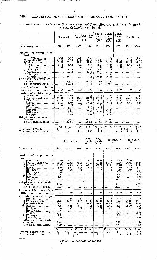
300 CONTRIBUTIONS TO ECONOMIC GEOLOGY; 1906, PART II.
Analyses of coal samples from Danforth Hills and Grand Hogback coal fields, in north western Colorado Continued.
Labor
Analy ceiv
X2
PM
5
Calori Ca B]
Loss c
Analyx o£'
^
Calori Ca Bi
Thick] Thicta
sis of sample as re ed:
/Ash.. ................
O XVPPTl
ic value determined :
f moisture on air dry-
sis of air-dried sample:
/Ash..................
Owppnic value determined:
less of part sampled. . .
Labor
Analy ceiv<
* £ *
+35'
Calori Ca Bi
Loss o ing.
Analy
H2-.*
+J p"
Calori Ca Br
Thicki Thicki
sis of sample as re- 2d:
fAsh. .................
ic value determined."
f moisture on air dry-
sis of air-dried sample:
/Ash..................
ic value determined :
itish thermal units. . . .
less of part sampled. . .
Newcastle.
0935.
4.04 37.66 52.56 5.74
" .53
1.10
.2.97 38.08 53.14
5.81 .54
Ft. in. 14 9
3939.
4.06 38.20 52.71 5.03 .51
1 9472.98
14.53
7,352 13,234
1.20
.2.90 38.06 53.35 5.09 .52
5.1773.871.73
13.62
7,441 13,394
Ft. in. 14 14
South Canyon, east Wheeler
bed.
3959.
6.55 36.63 47.89 8.93 .48
2.20
4.45 37.45 48.97 9.13 .49
Ft. in.18± 12 8
Coal Basin.
4047.
0.96 21.49 68. 93 8.62 .52
4.6679.611.834.76
7,961 14,330
.20
.76 21.53 69. 07 8.64 .52
4.6579.771.834.59
7,977 14,359
Ft. in. 20
9
4049.
1.22 22.02 67.84 8.92 .59
.40
.82 22.11 68.11 8.96 .59
Ft. in. a 20
9
4042.
1.27 22.38 67.35 9.00
.50
4
.40
.87 22.47 67.62 9.04 .50
Ft. in.
d960.
5.51 35.89 48.76 9.84
. .29 5.27
65.66 1.36
17.58
6,606 11,891
1.70
3.88 36. 51 49.60 10.01
.30 5.17
66.79 1.38
16.35
6,720 12, 106
Ft. in.
15 10
Sun light, Cbed.
4045.
5.65 36.29 52.89 5.17 .82
2.60
3.13 37.26 54.30 5.31 .84
Ft. in.
South Can
yon, D bed.
3961.
7.44 36.18 53.90 2.48 .47
5.36 69.73 1.65
20.31
7,047 12, 685
3.10
4.48 37.34 55.62 2.56 .49
5.18 71.96 1.70
18.11
7,376 13,090
Ft. in. 4 8 4 8
Sun light,
B bed.
4046.
6.93 35.55 52.73 4.79 .67
3.80
3.25 36.96 54.81 4.98
.69
Ft. in.
6
Gulch, Sun shine bed.
4010.
2.30 34.74 56.71 6.25 .44
5.23 76.12 1.54
10.42
7,766 13,979
1.20
1.21 35.17 57. 30 6.32 .45
5.16 77.05 1.56 9.46
7,860 14, 149
Ft. in. 14±
Gulch, Ander-
son bed.
4009.
2-77 35.15 58.68 3.40 .46
1.50
1.29 35.69 59.57 3.45 .47
Ft. in. 4 10 4 10
Sunlight, D bed.
4033.
5.19 47.77 43.21 3.83
.79
2.00
3.26 48.74 44.09 3.91 .81
Ft. in. 9± 4
4048.
6.49 37.23 53.38 2.90 .93
5.5671.511.79
17.31
7,299 13,138
3.50
3.10 38.58 55.32 3.00 .96
5.3674.101.86
14.72
7,564 13,614
Ft. in. 8 3 8 3
Coal Basin.
4041.
1.33 21.48
70.24 6.95
..51
.40
.93 21.57 70.52 6.98 .51
Ft. in. a 20
6 3
4043.
1.15 22.43 68.85 7.57
.48
. .30
.85 22.50 69. 06
' 7.59 .48
Ft. in. a 20
7 6
Sunlight, A bed. "
4032.
5.50 24.68 58.64 11.18
.69
2.80
2.78 25.39 60.33 11.50
.71
Ft. in. 30-
7 0
4034.
5.32 36.29 49.60 8.79 .76
5.26 67.76 1.58
15.85
6,902 12, 424
3.00
2.39 37.41 51.14 9.06 .78
5.08 69.86 1.63
13.59
7,115 12,808
Ft. in. 10 9 10 2
a Thickness reported; not verified.
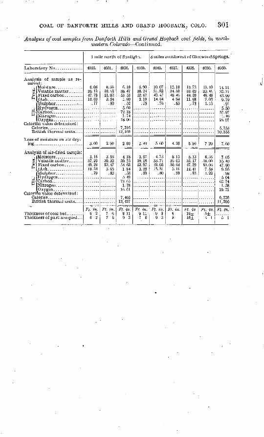
COAL OF DANFOKTH HILLS AND GRAND HOGBACK; COLO. 301
Analyses of coal samples from Danforth Hills and Grand Hogback coal fields, in north western Colorado Continued.
Labor
Analy ceive
iPM
4J3'
Calori Ca Bi
Loss o
AnalyK2' *
+j P
Calori Ca Bi
Thick] Thicta
sis of sample as re- ,d:
/Ash..................
ic value determined:
f moisture on air clry-
sis of air-dried sample:
(Ash. .................
Nitrogen..............Owfpri
Fic value determined :
less of part sampled . . .
1 mile north of Sunlight.
4035.
6.06 36.1347.78 10.03
.77
3.00
3.15 37.25 49.26 10.34
.79
Ft. in. 6 2 6 2
4031.
6.36 38.18 51.92 3.54
.80
2.90
3.56 39.32 53.47 3.65
.82
Ft. in. 1 6 7 6
4036.
6.10 38.47 53.53 1.90 .52
5.6072.181.74
18.06
7,31613, 109
2.00
4.18 39.25 54.63 1.94
.53 5.49
73.651.78
16. 61
7,46513, 437
Ft. in. 9 11 9 3
. 4039.
5.90 38.24 52.67 3.19
.58
2.40
3.57 39.18 53.97 3.28 .59
Ft. in. 9 11 7 6
8 miles southwest of Glenwood Springs.
4040.
10.07 31.82 43.47 14.64
.76
5.60
4.73 33.71 46.05 15.51
.80
Ft. in. 9 3 9 3
4037.
12.10 34.50 48.40 4.94 .85
4.30
8.15 30.05 50. 64
5. 16 .89
Ft. in.8 8
4038.
10.73 33.09 44.50 11.68
..78
5.90
5.13 35.17 47.29 12. 41
.83
Ft. in. 16± 16±
4030.
13.10 33.41 40.46 7.03 1.13
7.20
6.36 36.00 50.06 7.58 1.22
Ft. in. 5±4 1
4050.
14.11 32.71 43. 99 9.19
.91 5.50
57. 97 1.46
24. 97
5,753 10,355
7.60
7.05 35. 40 47.60 9.95 .98
5.04 62. 74 1.58
19.71
6,226 11,206
Ft. in.
5 1
THE BOOK CLIFFS COAL FIELD, BETWEEN GRAND RIYER, COLORADO, AND SUNNTSIDE, UTAH.
By G. B. RICHARDSON.
INTRODUCTION.
The Book Cliffs coal field is part of the southern edge of an immense basin in western Colorado and eastern Utah around which the out crop of coal-bearing rocks can be traced for more than 500 miles. PL XVIII shows the outline of this field. On the southwest from the vicinity of Mount Hilgard, Utah, northward to Castlegate, the coal measures form the eastern escarpment of the Wasatch Plateau. Thence they trend southeastward to Grand River, constituting in the Book Cliffs the southern rim of the Uinta Basin. Beyond Grand River the coal measures continue eastward, forming the southern base of Grand Mesa and extending to the vicinity of Crested Butte. From that place the outcrop trends northward and, crossing Grand River again in the vicinity of Newcastle, continues northward along the Grand Hogback to the Danforth Hills. Thence the coal meas ures turn westward and outcrop along the southern flank of the Uinta Mountains. This great coal field has been but partially prospected and mines are in operation in only a few localities, but enough of the area has been explored to prove that it is one of the most important coal reserves of the Rocky Mountain region.
Coal has long been known to be present in the Book Cliffs. The' geology of the region was first studied by A. C. Peale,a of the Hayden Survey, in 1876. The field is mentioned by R. C. Hills 6 in his report on the "Coal fields, of Colorado/' and by L, S. Storrs c in his paper on the "Rocky Mountain coal fields." Arthur Lakes has also re ferred to part of the area d and has described the Book Cliff mines.6But the coal was not examined in detail until 1905, when J. A. Taff/*" . of the United States Geological Survey, studied the western part of
a Geological report on the Grand River district: Tenth Ann. Rept.U. S. Geol.and Geog. Survey Terr., 1878, pp. 170-185.
b Mineral Resources U. S. for 1892, U. S. Geol. Survey, 1893, p. 353. c Twenty-second Ann. Rept. U. S. Geol. Survey, p. 3,1901, p. 436. <J The Grand River coal field: Mining Reports, vol. 51,1905, pp. 379-381. « The Book Cliff coal mines: Mines and Minerals, vol. 24,1904, pp. 280-291. / The Book CM? coalfield: Bull. U. S. Geol. Survey No. 285,1906, pp. 289-302.
302
BOOK CLIFFS COAL FIELD, COLORADO-UTAH. ' . 303
the field from the vicinity of Sunnyside to Castlegate, Utah, and its southern continuation along the escarpment of the Wasatch Plateau. During the summer of 1906 the writer, assisted by W. D. Neal, L. J. Pepperberg, and C. D. Perrin, made a reconnaissance survey of the eastern part of the Book Cliffs field, from the point where Mr. Taff' s work terminated to Grand River, Colorado. The following pages are an abstract of a more detailed report, which will soon be published.
TOPOGRAPHY.
The Book Cliffs form the southern margin of the Book or Tavaputs Plateau, which is separated from the San Rafael Swell and the Uncompahgre Plateau on the south by a broad lowland. The eleva tions range from 4,000 to 10,000 feet above sea level. The area is drained by Green and Grand rivers, which unite to form the Colorado about 60 miles south of the Book Cliffs.
The lowland at the base of the Book Cliffs extends in a curved but general westerly direction from Palisades, Colo., to Green River, Utah, and thence northwestward to Helper, a distance of 190 miles. In the area here considered this belt of lowland, averaging about 12 miles in width, lies between the Book Cliffs on the north and low hills on the south. It is an undulating desert plain that rises gently toward the bordering highlands. In the vicinity of the cliffs there are outlying buttes, and the shale is eroded into badlands. Adjoin ing the cliffs there are local fringing remnants of an old outwash gravel-covered plain through which the streams have cut their way 100 feet or more, and south of Grand River, near Palisades, a system of terraces is well developed.
The Book Cliffs extend from Grand River, Colorado, to Helper, Utah, at the east edge of the Wasatch Plateau. They occupy a belt from. 1 to 10 miles wide in which the' elevation rises from 2,000 to 6,000 feet. In places the rise is abrupt in one sharp precipitous slope, but usually it is accomplished by a series of cliffs and interven ing benches. The rocks composing the escarpments are alternating beds of sandstone and shale lying almost flat, and the strata present the appearance of the leaves of a book when lying on one side; hence the name.
In the area here discussed the cliffs extend in an S-shaped belt from Palisades to Sunnyside. At the east they are much dissected by Roan Creek and its tributaries, and a subordinate escarpment known .as the Little Book Cliffs extends northwestward from the mouth of the Grand River canyon. The top of the Little Book Cliffs marks the crest of a hogback whose northeastern flanks consti tute a dip slope, and the area between the Little Book Cliffs and Roan Creek is a gentle northeastward-sloping monocline, dissected by southeastward-flowing streams.
9411 Bull. 316 07 20
304 CONTRIBUTIONS TO ECONOMIC GEOLOGY, 1906, PART II.
West of the headwaters of Roan Creek the Book Cliffs proper extend to the end of the area mapped. Erosion by East and West Salt Creek has caused the rim of the Book Plateau to recede so that the distance between the lowlands and the plateau, a few miles east of the Utah-Colorado boundary, is unusually large. Between the State line and Green River this distance averages about 10 miles. Here a low bench, that is not. present elsewhere, forms the base of the cliffs. It is caused by a great lens of sandstone which is overlain by shale. Above this lowest bench there is a succession of dissected benches and escarpments up to the level of the plateau.
Green River has produced another embayment in the cliffs, and Price River in its canyon course separates a small area, known as the Beckwith Plateau, from the main mass of the upland. The Beckwith Plateau is considerably dissected on the north and east, but faces the lowland on the west in a practically unbroken scarp over 1,500 feet high. Northwest of the Beckwith Plateau to the end of the area studied, a line of cliffs, which form the base of an eastward-sloping shelf, rises 1,000 to 1,500 feet directly above the lowland. Above this shelf another but more dissected line of cliffs rises 1,500 feet higher.
The crest of the Book Cliffs forms the southern rim of the Book Plateau, or, as it is known in Utah, the Tavaputs Plateau, which, viewed from the south, exhibits an even sky line. This plateau slopes gently northward toward the axis of the Uinta Basin, but is much dissected by deep canyons.
STRATIGRAPHY.
In the Book Cliffs coal field, the rocks are all sedimentary and are divisible into four distinct lithologic groups which range in age from Dakota to Eocene.
The Dakota possesses the characteristic features common to the formation in this general region. It is a variable series of buff quartzitic sandstone, commonly conglomeratic, with a few layers of carbonaceous shale and low-grade coal. Generally it ranges in thick ness from 25 to 200 feet, but in places it is wanting, evidently having been deposited unconformably upon an old land surface. The out crop occupies a narrow belt of low hills parallel to and about 10 miles south of the Book Cliffs.
Above the Dakota there are several thousand feet of clay shale, which underlies the broad central lowland and forms the base of the Book Cliffs. The shale is black or blue-gray to drab in color, and contains local lenses of limestone and at the top thin beds of buff sandstone. It is much broken by cracks and joints, many of which contain thin films of alkaline salts that locally effloresce in patches of white powder. The unreclaimed areas of shale are characteristically coated with "alkali." The shale is about 3,000 feet thick. It con-
BOOK CLIFFS COAL FIELD, COLORADO-UTAH. 305
tains Colorado fossils at the base and Montana fossils near the top and is correlated with the Mancos shale of southwestern Colorado.
Well-exposed sections in the face of the cliffs show that the shale grades upward into the overlying formation with no -apparent break in sedimentation and a sharp boundary can not be drawn between them. The overlying rocks consist of alternating beds of buff sand stone and drab or carbonaceous shale with workable beds of coal in the lower part. These are the escarpment-making rocks of the Book Cliffs and are clearly exposed throughout the area. About a third of the formation is composed of shale, most of which occurs in the lower half, while the upper part consists largely of sandstone. The areal distribution of the different strata is varied and no two sections are exactly alike. Some beds of sandstone, however, are persistent for several miles. The thickness of the formation decreases toward the west and ranges from about 2,200 to 1,200 feet. Fossils have been found at several horizons between 200 feet from the base and 250 feet from the top of the formation. They consist of land plants and fresh- and brackish-water invertebrates. The evidence-: of the fossils and the general stratigraphic and oval relation of the beds together indicate that the coal-bearing formation should be referred to the Mesaverde rather than to the Laramie. The transition from the Mancos to the Mesaverde is marked lithologically by the increasing prevalence of sand and paleontologically by the change from marine to brackish- and fresh-water conditions. On lithologic grounds all the coal beds would be classed with the sandstone-shale formation, the greater part of which at least is considered to be Mesa\7 erde.
Strata of Eocene age cap the Book Cliffs and for many thousand square miles constitute the floor of the Uinta Basin to the north. The basal Eocene beds are composed of local conglomerate, varicolored shale, buff sandstone, and subordinate thin lenses of limestone in which fossils, referred to the Wasatch stage, have been found. The stratigraphy is characteristically varied and many adjacent sections are very unlike; in one place the varicolored shales predominate and in another they are inconspicuous. The conglomerate is also variable in occurrence. In some sections none was seen, whereas others show about 25 feet of it. It is composed of rounded pebbles of quartz, quartzite, and chert, colored red, pink, black, and white, in a sandy matrix. No structural discordance was found between the two for mations, but locally the conglomerate lies upon an undulatory surface of the underlying rocks. Other evidences of unconformity at the base of the Eocene are the westward thinning of the Mesaverde and the difference in general character between the two formations, repre senting the change from brackish- and fresh-water sediments to those laid down under more diverse conditions of deposition, probably in part subaerial and in part lacustrine.
306 CONTRIBUTIONS TO ECONOMIC GEOLOGY, 1906, PART II.
COAL.
Coal of commercial importance occurs in the Book Cliffs in the lower part of the sandstone-shale formation at intervals between 35 and 700 feet above the shale that underlies the lowland. It occurs at different horizons, and no bed has been traced continuously for more than a few miles. In one locality several beds of coal are present, while in others only one or two have been found. The thickness ranges from 21 feet down to mere films of carbonaceous matter. The section on PL XVIII indicates the general sequence of the rocks.
OCCURRENCE AND THICKNESS.
The following description begins at the east and proceeds westward, and in following it the map (PL XVIII) will be of service:
At the east end of the Book Cliffs there are two workable beds of coal. The lower one occurs between 35 and 60 feet above the top of the shale that underlies the lowland and, though variable, is com monly about 4 feet thick. The upper coal is thicker, in places meas uring 9 feet, and occurs from 200 to 500 feet above the lower beds. These coals have been prospected at several localities between the Cameo mine (No. 1 on the map) and the Farmer's mine (No. 13), and, though they have not been actually traced throughout that distance and are known to vary in thickness, the beds appear to be continuous. Besides these two main coals there are usually one or more thin beds, but no others of commercial importance have yet been found.
The lower coal, also known as the Palisades coal, outcrops at water level near the mouth of the Hogback Canyon of Grand River about 1£ miles above Palisades. Thence the coal can be traced westward along the base of the Book Cliffs for many miles. At first it rises rapidly above the valley. At the Palisades mine (No. 6 on the map) the coal is about 150 feet above the valley, at the Garfield mine (No. 7) it is 800 feet, and at the old Book Cliff mine (No. 9) the Palisades coal is about 1,200 feet above the river. In this distance the coal can be easily followed; at many places it is exposed by erosion, appearing as a black streak in the cliffs, and it is usually underlain by a massive white sandstone which is conspicuous as the first heavy sandstone bed above the shale. This sandstone is not persistent, however, but locally thickens and thins and gives way to shaly beds. The Palisades coal varies in thickness, ranging from a few inches to 6 feet.
At the Riverside mine (No. 4), a mile northeast of Palisades, the following section is exposed near the mouth of the mine: .
Section of coal bed at Riverside mine.Shale.
Coal.................................Shale...............................Coal.................................
Ft. in. .......................... 6......................... 3..................... ...'.. 2 6
3 3
U. S. GEOLOGICAL SURVEY BULLETIN NO. 316 PL. XVIII
COX.TJMNAH SECTION
£&., 1000 ft. ofvan'-colored sna le. sandstone, thin conglomerate, and Itm cstone
1200 to 2ZOO ft. of buff sandstone and drab shale nith beds of coal in lotfer part
3000 ft.*, of fissile blac\ to drab clay shale and local th lenses oflimesto
MAP OF PART OF THE
BOOK CUFFS COAL FIELDOr
'COLORADO -AND UTAHby G.'B.ftichardson and L.J. Pepperbers
100 ft.+of sandstone, con$tomerate,anet shal<
11.00 feel
A
SECTION ALONG LINE A-B10)000 ft.
5000
BOOK CLIFFS COAL FIELD, COLOBADO-TJTAH. SOT
At the face of the workings the shale parting is an inch and a half thick, and the lower bench of coal measures 2 fe^t 10 inches.
At the Palisades mine (No. 6) there are fror> 3 feet 7 inches to 3 feet 10 inches of clean coal. Two miles farther west, at the Garfield mine, the Palisades coal attains the greatest thickness yet measured. The following section is there exposed:
Section of coal bed at Garfield mine.
Sandstone, shaly. Coal........................................
Coal........................................
Coal........................................
Coal........................................Shale, carbonaceous ....................
Ft. ]
.................. 1
.................. 3
................... 1.................. 1
in. 19,
9
i?.
Sandstone.
Total coal bed.......................................... 7 11J
In the vicinity of the old Book Cliff mine the lower coal is of vari able thickness; in places it measures almost 5 feet, whereas near by it thins out to almost nothing. It is reported that in working the lower coal in the old Book Cliff mine several barren areas were encountered in which the coal was absent. Northwest of the old mine evidences of thinning are shown by the outcrops.
West of the Book Cliff mine less prospecting has been done, and little variation has been found. At the Steele or Keystone mine (No. 11) there are 5 feet 3 inches of coal, including 4 inches of bone 1 foot from the top. The roof and floor are of shale, and the coal lies 3 feet above a bed of massive white sandstone.
At the Black Diamond mine (No. 12) the following section was measured:
Section of coal bed at Slack Diamond mine.
Shale. Coal................................Clay..............................Coal................................
Shall*
Ft. in. Q-ll
......................... 1-3
......................... 4 8
Locally the coal decreases in thickness to 3 feet. At the Farmer's mine the lower coal seems to have decreased to 30 inches, but in this vicinity the upper coal is of-more value.
Except at two important mines, the Book Cliff (No. 10) and the Cameo (No. 1), the upper coal is not worked. This is due to the fact that the lower coal in general is of better quality and more accessible, occurring several hundred feet lower down the steep cliffs.
308 CONTKIBUTIONS TO ECONOMIC GEOLOGY, 1906, PART II.
The upper bed, which is known as the Cameo coal, outcrops at river level at Cameo station. It rises to the southwest, and north of Palisades is about 650 feet above the valley, lying at the base of the second tier of cliffs. From Palisades the outcrop extends northwest ward to the vicinity of the Book Cliff mine, at a distance of about 1£ miles from the crest of the lower escarpment. Thence westward the bench below the upper coal disappears, and the two coals outcrop in the face of the cliffs almost directly one above the other. The posi tion of the upper coal is marked locally by a massive white sandstone almost immediately beneath it. This sandstone is 75 feet thick and can be traced for miles, but it is not constant and in places disappears.
Between the Cameo and Bob Cat mines the thickness of the upper coal as exposed in mines or .prospects ranges between 4 feet 4 inches and 9 feet 8 inches, with one or two partings of shale or bony coal ranging from 5 inches to 3 feet 5 inches.
In the Cameo mine the roof is a good, firm sandy shale, and the floor where the full thickness of coal is worked is reported to be sand stone, but usually the total thickness of the coal is not removed. The coal here has the reputation of being dirty. The following measure ments were made in the main entry of the mine:
Section of coal bed in the Cameo mine.
Coal....................
Coal....................Bone.. .................Coal....................
Ft. in. ...................................... 3 10...................................... 1..................:................... 3 10...................................... l 2..:..,............................... 2
10 11
At a prospect north of Palisades the following section is exposed:
Section of coal at prospect north of Palisades.Ft. in.
Coal.......................................................... 3 6Bone......................................................... 1Coal.......................................................... 2 5
6
At the Book Cliff mine (No. 10) about 7 feet of the upper coal are worked, and at the end of the main entry the following section was measured:
Section of coal bed in Book Cliff mine.Ft. in.
Coal...............,....'.............'...............:......... 3Bone......................................................... JCoal...................I...................................... 4 6
BOOK CLIFFS COAL FIELD, COLORADO-UTAH. 309
About a quarter of a mile east of the Steele mine (No. 11) a stripping was made which showed:
Section of coal bed one-fourth mile east of Steele mine.Ft. in.
Coal.......................................................... 2 6Bone......................................................... 5Coal..........................'................................ 3 2
Shale.................................................... 8Sandstone.
Total coal bed........................................... 6 1
At the Bob Cat mine (No. 14) and in that vicinity between 44 and 55 inches of clear coal are exposed at the upper coal horizon, which occurs about 400 feet above the lower bed worked at the Farmer's mine. West of the Bob Cat mine the upper coal has not been pros pected, and little is known of it for several miles.. The coal outcrops high in the face of the cliffs, and the lower bed is more accessible.
Two small openings on the lower coal west of the Farmer's prospect are known as the Excelsior and Corcoran mines. The Excelsior mine (No. 15) is located high up a hillside near the head of a small gulch, where the coal is opened along the outcrop at several places. At the entrance to the workings 4 feet 7 inches of coal is exposed. Four feet above is a 4-inch bed and a foot and a half below there are 2 inches of coal, while 40 feet below the main coal there is an unpros- pected bed of coal and carbonaceous shale 6 feet thick. A mile west of the Excelsior there is a small abandoned prospect known as the Corcoran mine (No. 16) where the workings have caved in, but there are at least 4 feet of coal exposed near the entrance.
For 5 miles northwest of the Corcoran property little or no pros pecting has been done, but at the next open valley there are prospects on both the upper and lower coals. An opening on the lower bed shows the following section:
Section of coal bed 5 miles northwest of Corcoran mine.
Sandstone. Ft. in. Shale.................:.........-.............................. 6Coal..:............'...........................................Bone.........................................................Coal..........................:............./.................
Shale.....:..............................................Sandstone.
Total coal bed........................................... 5 10
310 CONTKIBUTIONS TO ECONOMIC GEOLOGY, 1906, PAET IT.
Farther up the same valley the upper coal is well exposed and has been worked at the Hunter mine (No. 17), where the following section was measured:
Section of coal beds at Hunter mine.Sandstone. Ft. in.
Coal.......................................................... 2Bone. .................................. s..................... 4Coal........................................................... 4 5Bone. ................................................ ̂ ....... 8Coal.......................................................... 7
Sandstone............................................... 25Coal.......................................................... 2Bone......................................................... 1Coal.......................................................... 3
Sandstone.
39
Northwestward along the cliffs no prospects were found for 5 miles northwest of the Hunter property, where the Gross or Kiel mine is situated, near the mouth of Kiel Canyon. At this mine (No. 18) between 3 feet and 3 feet 9 inches of coal are exposed.
The next opening is about 1£ miles west of Kiel Canyon at the Nugent mine (No. 19). Here there are two openings on the lower coal on opposite sides of a gulch. The coal is from 4 feet 3 inches to 4 feet 8 inches thick.
At the Nearing mine (No. 20), three-fourths of a mile west of the Nugent, the same bed is worked. At the mouth of the mine the coal measures 4 feet to 4 feet 2 inches and contains a variable streak of bone up to 12 inches thick. At the end of the workings the bone disappears and the coal measures 4 feet 7 inches. The coal is here 45 feet above the top of the shale, and in this general vicinity thehigher coal appears to be represented by only thin carbonaceouslayers. Only one workable coal has yet been found here.
Openings have been made on the coal at the Lane and Johnson mines, on opposite sides of the creek about 2 miles northwest of the Nearing property. The following measurements were made:
Section of coal bed at Johnson mine (No. 22).
Sandstone. Shale, carbonaceous. .....................
Coal.........................................
Coal...................../...................
Ft. in. .................. 5................... 1 6................... 3.................. 4
Total coal bed........................................... 5 9
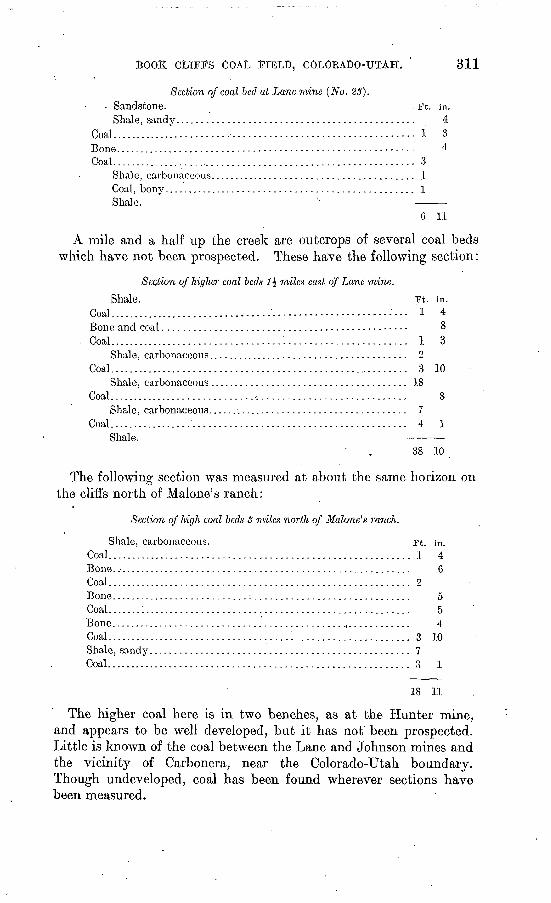
BOOK CLIFFS COAL FIELD, COLORADO-UTAH. 311
Section of coal bed at Lane mine (No. 23). Sandstone. ^ Ft. in.
Shale, sandy.............................................. 4Coal........................................................... 1 3Bone.........................................-..: 4Coal............................................................ 3
Shale, carbonaceous........................................ 1Coal, bony................................................. 1Shale. -
6 11
A mile and a half up the creek are outcrops of several coal beds which have not been prospected. These have the following section:
Section of higher coal beds 1\ miles east of Lane mine.
Shale. Ft. in. Coal...............................-..--..-.--- - -- "l 4Bone and coal............................................... 8
. Coal..................................:....................... 1 3Shale, carboiiaceous....................................... 2
Coal.............................:...................,........ 3 10Shale, carbonaceous...................................... 18
Coal.......................................................... 8Shale, carbonaceous....................................... 7
Coal.........;................................................ 4 1Shale. _____
38 10
The following section was measured at about the same horizon on the cliffs north of Malone's ranch:
Section of high coal beds <? miles north of Malone's ranch.
Shale, carbonaceous. Ft. in. Coal........................................................... 1 4Bone........................................................... 6Coal ........................................................... 2Bone.......................................................... 5Coal.......:................................................... 5Bone........................................................... 4Coal........................................................... 3 10Shale, sandy.................................................. 7Coal........................................................... 3 1
18 11
The higher coal here is in two benches, as at the Hunter mine, and appears to be well developed, but it has not been prospected. Little is known of the coal between the Lane and Johnson mines and the vicinity of Carbonera, near the Colorado-Utah boundary. Though undeveloped, coal has been found wherever sections have been measured.
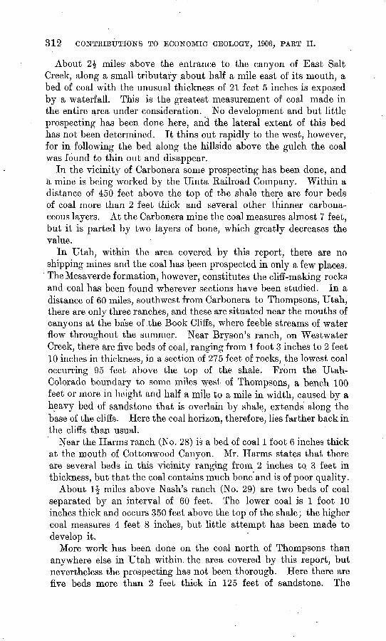
312 CONTRIBUTIONS TO ECONOMIC GEOLOGY, 1906, PART II.
About 2£ miles' above the entrance to the canyon of East Salt Creek, along a small tributary .about half a mile east of its mouth, a bed of coal with the unusual thickness of 21 feet 5 inches is exposed by a waterfall. This is the greatest measurement of coal made in the entire area under consideration. No development and but little prospecting has been done here, and the lateral extent of this bed has not been determined. It thins out rapidly to the west, however, for in following the bed along the hillside above the gulch the coal was found to thin out and disappear.
In the vicinity of Carbonera some prospecting has been done, and a mine is being worked by the Uinta Railroad Company. Within a distance of 450 feet above the top of the shale there are four beds of coal more than 2 feet thick and several other thinner carbona ceous layers. At the Carbonera mine the coal measures almost 7 feet, but it is parted by two layers of bone, which greatly decreases the value.
In Utah, within the area covered by this report, there are no shipping mines and the coal has been prospected in only a few places.
' The Mesaverde formation, however, constitutes the cliff-making rocks and coal has been found wherever sections have been studied. In a distance of 60 miles, southwest from Carbonera to Thompsons, Utah, there are only three ranches, and these are situated near the mouths of canyons at the base of .the Book Cliffs, where feeble streams of water flow throughout the summer. Near Bryson's ranch, on Westwater Creek, there are five beds of coal, ranging from 1 foot 3 inches to 2 feet 10 inches in thickness, in a section of 275 feet of rocks, the lowest coal occurring 95 feet above the top of the shale. From the Utah- Colorado boundary to some miles west of Thompsons, a bench 100 feet or more in height and half a mile to a mile in width, caused by a heavy bed of sandstone that is overlain by shale, extends along the base of the cliffs. Here the coal horizon, therefore, lies farther back in the cliffs than usual.
Near the Harms ranch (No. 28) is a bed of coal 1 foot 6 inches thick at the mouth of Cottonwood Canyon. Mr. Harms states that there are several beds in this vicinity ranging from 2 inches to. 3 feet in thickness, but that the coal contains much bone and is of poor quality.
About 1£ miles above N ash's ranch (No. 29) are two beds of coal separated by an interval of 60 feet. The lower coal is 1 foot 10 inches thick and occurs 350 feet above the top of the shale; the higher coal measures 4 feet 8 inches, but little attempt has been made to develop it.
More work has been done on the coal north of Thompsons than anywhere else in Utah within the area covered by this report, but nevertheless the prospecting has not been thorough. Here there are five beds more than 2 feet thick in 125 feet of sandstone. The
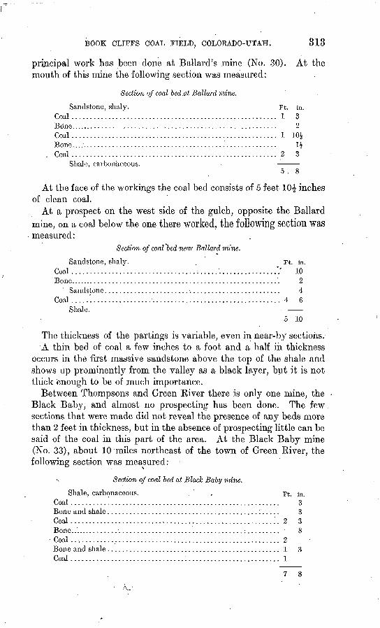
BOOK CLIFFS COAL FIELD, COLOEADO-TJTAH. 313
principal work has been done at Ballard's mine (No. 30). At the mouth of this mine the following section was measured:
Section of coal bed .at Bollard mine.
Sandstone, shaly. Coal ...................................
Coal ...................................
Coal ...................................
Ft. in....................... 1 3..........'............ 2............'.......... 1 30J......:.............. u..................... 2 3
Shale, carbonaceous.
At the face of the workings the coal bed consists of 5 feet 10£ inches of clean coal.
At a prospect oil the west side of the gulch, opposite the Ballard mine, on a coal below the one there worked, the following section was measured:
Section of coal "bed near Ballard mine.
Sandstone, shaly. .. Ft. in.Coal .................-........... ......-...... ................': 10Bone.......................................................... 2
Sandstone .................................................. 4Coal .....'.................................................... 4 6
Shale.
5 10
The thickness of the partings is variable, even in near-by sections.A thin bed of coal a few inches to a foot and a half in thickness
occurs in the first massive sandstone above the top of the shale and shows up prominently from the valley as a black layer, but it is not thick enough to be of much importance.
Between Thompsons and Green Kiver there is only one mine, the Black Baby, and almost no prospecting has been done. The few sections that were made did not reveal the presence of any beds more than 2 feet in thickness, but in the absence of prospecting little can be said of the coal in this part of the area. At the Black Baby mine (No. 33), about 10 miles northeast of the town of Green River, the following section was measured:
s Section of coal bed at Black Baby mine.
Shale, carbonaceous. Coal ..................................Bone and shale ........................Coal ..................................Bone....... ............................Coal ..................................Bone and shale . '. ......................Coal ..................................
Ft.
....................... 2
....................... 2
....................... 1
....................... 1
in. 333R
3
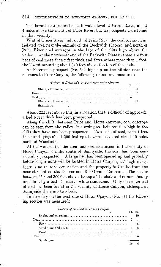
814 CONTRIBUTIONS TO ECONOMIC GEOLOGY, 1906, PART II.
The lowest coal passes beneath water level at Green River, about 4 miles above the mouth of Price River, but no prospects were found in that vicinity.
West of Green River and south of Price River the coal occurs in an isolated area near the summit of the Beckwith Plateau, and north of Price River coal outcrops in the face of the cliffs high above the valley. At the northwest end of the Beckwith Plateau there are four beds of coal more than 2 feet thick and three others more than 1 foot, the lowest occurring about 340 feet above the top of the shale.
At Peterson's prospect (No. 34), high up on the hillside near the entrance to Price Canyon, the following section was measured:
Section at Peterson's prospect near Price Canyon.Ft. in.
Shale, carbonaceous....................................... 8Bone.......................................................... 1 2Coal......................................................... 4
Shale, carbonaceous....................................... 10Sandstone.
About 225 feet above this, in a location that is difficult of approach, a bed 6 feet thick has been prospected.
Along the cliffs, between Price and Horse canyons, coal outcrops can be seen from the valley, but owing to their position high in the cliffs they have not been prospected. Two beds of coal, each 4 feet thick and lying about 200 feet apart, were measured about 10 miles north of Woodside.
At the west end of the area under consideration, in the vicinity of Horse Canyon, 6 miles south of Sunnyside, the coal has been con siderably prospected. A large bed has been opened"up and probably before long a mine will be located in liorse Canyon, although as yet there is no railroad connection and the property is 7 miles from the
.nearest point on the Denver and Rio Grande Railroad. The coal is between 250 and 300 feet above the top of the shale and is immediately underlain by a bed of massive white sandstone. . Only one main bed of coal has been found in the vicinity of Horse Canyon, although at Sunnyside there are two beds.
In an entry on the west side of Horse Canyon (No. 37) the follow ing section was measured:
Section of coal bed in Horse Canyon.
Coal.........................:............-.--...........
Coal .....................................................
Ft.
..... 2
..... 1
..... 1
..... 13
in. 10
1fifi
5
19
BOOK CLIFFS COAL FIELD, COLOKAPO-TJTAIL 315
A mile and a half farther south, at prospect No. 36, the section is as follows:
Section of coal bed at prospect, No. 36.
Sandstone, thin-bedded. Ft. in.Coal.......................................................... 2 4Sandstone and shale. ...............-.-..............:........ 1 6Coal.. .............................. ̂ ..............:.....\.... 9 2Bone......................................................... 2Coal......................-.......'....-....................... 6 4
19 6
AMOUNT OF AVAILABLE COAL.
A close estimate can not be made of the total amount of. coal avail able, because of the present limited knowledge of this field. A rqugh approximation may be reached, however, by assuming that the prac tical limit of the field is 6 miles back from the outcrop and that the total thickness of coal may be represented by a single bed 7 feet thick extending throughout the -area. The latter figure introduces an element of much uncertainty, inasmuch as the coals have not been continuously traced. On this basis there are in the area here con sidered about 1,010 square miles of coal land, 360 of which are in Colorado. A cubic foot of coal of 1.3 specific gravity weighs 81.25 pounds and a square mile of such coal 1 foot thick contains 1,132,544 short tons. Therefore on the above assumption the total amount is over 8,007,086,000 tons; deducting one-fourth for waste in mining leaves about 6,005,000,000 tons. These figures are perhaps of little more value than to express the fact that there is here an immense coal reserve.
COMPOSITION OF THE COAL.
The following analyses show the composition of coal from a number of localities in the area under discussion. The samples were collected under uniform conditions and represent the freshest available material. In general, however, because there are only a few working mines, most of the samples obtained were more or less affected by weather ing. The specially poor ones are indicated in the list on p. 317. .The samples were collected by cutting a channel across the face of the coal from roof to floor, partings over a quarter of an inch in thickness being rejected. The material was gathered on canvas, crushed, mixed, and quartered down to about 3 pounds and sent to the labo ratory in a sealed can. The analyses were made by F. M. Stanton, chief chemist of the fuel-testing plant of the United States Geological Survey, under uniform conditions prescribed by N. W. Lord, in charge of chemical work. a
" Prof. Paper U. S. Geol. Survey No. 48,1906, p. 174. ^
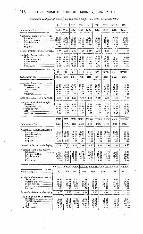
316 CONTRIBUTIONS TO ECONOMIC GEOLOGY, 1906, PAET II.
Proximate analyses of coals from the Book Cliffs coalfield, Colorado-Utah.
Analysis of sample as received:
Ash..............'...........
Loss of moisture on air drying. .
Analysis of air-dried sample:
Ash.........................
Laboratory No .................
Analysis of sample as received:
Ash. ........................
Loss of moisture on air drying. .
Analysis of air-dried sample:
Fixed carbon. ............. Ash.........................
Analysis of sample as received :
Ash................-..:....
Loss of moisture on air drying.
Analysis of air-dried sample:
Ash. .......................
3
Analysis of sample as received
Ash......................
Loss of moisture on air drying
Analysis of air-dried sample:
Ash......................
I.
3550.
8.42 33.32 47.53 10.73
.60
4.30
4.30 34.82 49.67 11.21 1.12
X.
3490.
11.42 34.25 44.49 9.84 -.84
5.60
6.17 36.28 47. 13 10.42 1.30
XIX.
3587.
9.44 35.51 49.33 5.72 1.02
5.50
. 4.17
. 37.58
. 52.20
. 6.05
. 1.39
:xvin.
3854.
12.74 33.04 50.06 4.16
.46
4.50
8.63 34.60 52.42
4.35 1.52
II.
3547.
8.17 33.69 53:42
4.72 .57
2.80
5.52 34.66 54.96
4.86 1.59
XI.
3496.
10.75 34.83 47.58 6.84
.55
3:50
7.51 36.09 49.31 7.09 1.32
XX.
35Su..
9.73 35.27 49.95 5.05
. 1.30
5.20
4.78 37.20 52.69 5.33 1.41
XXIX
3856.
6. 35 31.89 42.74 19.02
.55
2.3C
4.1' 32.6'
. 43.7, 19.4 1.3
III.
3542
7.55 31.07 48.27 13.11
.57
2.60
5.^)8 31.90 49.56 13.46 1.55
XII.
3494.
10.89 34.12 44.77 10.22 1.09
5.20
6.00 35.99 47.23 10.78
1.31
XXI.
3586.
8.27 36.90 48.67 6.16 1.26
3.60
4.84 38.28 50.49 6.39 1.32
. XXX
3857.
9.57 32.37 47.09 10.97
.«
' 2.5C
I 7.2£ I 33. 2C > 48. 3Cr 11.2,t 1.4,
IV.
3540.
4.71 34.68 52.66 7.95
.56
.10
4.61 34.72 52.71 7.96 1.52
XIII.
3581.
11.03 35.90 46.35 6.72 .68
5.80
5.55 38.11 49.21 7.13 1.29
XXII.
3584.
5.55 36.01 52. 75 5.69 .93
1.60
4.01 36.60 53.61 5.78 1.46
V.
3546.
7 33 52
5
2
57 56 91 96
.72
20
5.49 34.32 54.10 6.09 1.58
XIV.
3495.
9.54 34.49 46.33 9.64
.78
3.10
6.65 35.59 47.81 9.95 1.34
XXIII
3730.
18.63 30.61 46.28 4.48 .38
9.10
10.48 33.68 50.91
4.93 1.51
. XXXI.
3945.
5.58 32.77 43.61 18.04
.72
1.90
3.75 ) 33. 41
44.45 > 18.39 > 1.33
VI.
3541.
7.52 36.03 50.46 5.99
.85
2.00
5.63 36.77 51.49 6.11 1.40
XV.
3493.
15.39 32.57 45.69 6.35
.62
7. 20
8.83 35.10 49.23 6.84 1.40
XXIV
3728.
9.32 33.64 49.52 7.52 .51
3.00
6.52 34.68 51.05 7.75 1.47
XXXII.
3957.
4.75 33.58 50.24 11.43 1.15
2.30
2.51 34.37 51.42 11.70 1.50
VII.
3549.
8.77 36.55 48.72 5.96
.83
2.50
6.43 37.49 49.97 6.11 1.33
XVI.
3489.
&.86 34.20 43.90 15.04
.62
1.80
5.15 34.83 44.70 15.32 1.28
XXV
3729.
10.96 32.19 42.45 14.40
.48
4.50
6.76 33.71 44.45 15.08 1.32
xxxni. :
4014.
9.79 33.39 50.44 6.38
.60
3.50
6.52 34.60 52.27 6.61 1.51
VIII.
3539.
9.02 34.51 50.89 5.58
.67
3.10
6.11 35.61 52/52 5.76 1.47
XVII.
3488.
6.52 35.75 48.37 9.36
.67
.60
5.96 35.96 48.66 9.42 1.35
XXVI.
3732.
10.77 33.68 48.36 7.19 .56
3.90
7.15 35.05 50.32 7.48 1.44
?XXIV.
4013.
9.01 31.78 51.03 8.18
.46
4.10
5.12 33.14 53.21 8.53 1.61
IX.
3545.
13.96 31.30 48.73 6.01 .63
4.40
10.00 32.74 50.98 6.28 1.56
XVIII.
3640.
5.40 33.30 55.57 5.73
.49
.20
5.21 33.36 55.69 5.74 1.67
XXVII.
3734.
11.23 31.51 45.31 11.95 ' .42
4.70
6.85 33.07 47.54 12.54 1.44
XXXV.
4015.
5.20 36.03 52.69 6.08
.83
2.90
2.37 37.11 54.27 6.25 1.4G
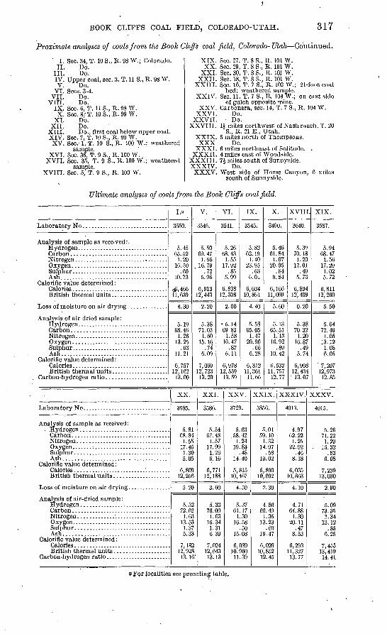
BOOK CLIFFS COAL FIELD, COLORADO-UTAH. 317
Proximate analyses of coals from the Book Cliffs coal field, Colorado- Utah Continued.
I. Sec. 34, T. 10 S., R. 98 W.; Colorado.II. Do.
III. Do.IV. Upper'coal, sec. 3, T. 11 S., R. 98 W. V. Do.
VI. Sees. 3-4. VII. Do.
VITI. Do.IX. Sec. 0, T. 11 S., R. 98 W.X. Sec. 8,'T. 10S., R.99 W.
XI. Do.XII. Do.
XIII. Do., first coal below upper coal.XIV. Sec. 7, T. 10 S., R. 99 W.XV. Sec.-1, T. 10 S., R. 100 W.; weathered
sample.XVI. Sec. 36, T. 9 S., R. 100 W.
XVII. Sec. 35, T. 9 .S., R. 100 W.; weathered sample.
XVIII. Sec. 5, T. 9 S., R. 100 W.
XIX. Sec. 27, T. 8 S., R. 101 W.XX. Sec. 29, T. 8 S., R. 101 W.
XXL Sec. 30, T. 8 S., R. 101 W.XXII. Sec. 18, T. 8 S., R. 101 W.
XXIII. Sec. 16, T. 7 S., R. 102 W.; 21-foot coal bed; weathered sample.
XXIV. Sec. 11, T. 7 S., R. 104 W.; on east side of gulch opposite mine.
XXV. Carbonera, sec. 14, T. 7 S., R. 104 W.XXVI. Do.
XXVII. Do. XXVIII. 1J miles northwest of Nash ranch, T. 20
S., R. 21 E., Utah.XXIX. 5 miles north of Thompsons. XXX Do.
XXXI. 6 miles northeast of Solitude. .XXXII. 4 miles east of Woodside.
XXXIII. 7£ miles south of Surmyside.XXXIV. Do.XXXV. West side of Horse Canyon, 6 miles
south of Sunnyside.
Ultimate analyses of .coals from the Boole Cliffs coalfield.
Analysis of sample as received : .
Ash ......................................Calorific value determined :
Analysis of air-dried sample: Hydrogen. . ..............................
OwfPTl
Ash......................................Calorific value determined:
Analysis of sample as received:
Ash......................................Calorific value determined :
Analysis of air-dried sample:
Ash.....................................Calorific value determined :
I.o
3550.
5.4565.52
1.20 16. 50
.60 10.73
<&4G6 11,639
4.30
5.19 68.46
1.26 13.25
.63 11.21
18,757 12, 162
13. 00
V.
3546.
5. 5069.47
1.5G 16.79
.72 5.96
6,913 12, 443
2.20
5.38 71.03
1.60 15. 16
.74 6.09
7,069 12, 723 13.20
XX.
3585.
5. 81 68.84
1.55 17.45 1.30 5.05
6,809 12, 256
5.20
5.5 72.6
1.0 13.5 1.3 5.3
7,18 12,92
13 1
2 2 3 3 7 3
2S6'
VI.
3541.
5.26 68.43
1.55 17.92
.85 5.99
6,838 12,308
2.00
5. 14 69.83
1.58 16.47
.87 6.11
6,978 12,559
13. 59
XXI.
3586.
5.54 67.48 1.57
17.99 1.20 6.16
6,771 12, 188
3.60
5.33 70.00
1.63 15.34
1.31 6.39
7,024 12,643 13.13
IX.
3545.
5.82 02.19
1.40 23.95
.63 6. 01.
6,034 10,801
4.40
5.58 65.05
1.47 20.96
.66 0.28
6,312 11,361
11.66
XXV.
3729.
5.63 58.42
1.24 19.83
.48 14.40
5, 815 10, 467
4.50
5.37 61.17 1.30
16. 58 .50
15.08
6,089 10.960 11.39
X.
3490.
5.46 61.84
1.07 20.95
.84 9.84
6, 166 11,099
5.60
5.13 65. 51
1.'13 16.92
.89 10. 42
6, 532 11,757 12.77
XXIX.
3856.
5.01 59.10
1.32 14.97
.58 19. 02
5,890 10, 602
2.30
4.86 60.49
1.35 13.23
.60 19. 47
6,029 10,852
12. 45
XVIII
3640.
5.39 70.18
1.20 17.01
.49 5.73
6,894 12, 409
0.20
5. 38 70.32 1.20
16.87 .49
5.74
6,908 12, 434 13.07
XXXIV.
4013.
4.97 62. 22
1. 25 22.92
.46 8.18
6,035 10, 863
4.10
4.71 64.88
1.30 20.11
.47 8.53
6,293 11,327
13. 77
. XIX.
3587.
5.94 68.47
1.56 17.29 1.02 5.72
0,811 12, 260
5.50
5.64 72.46
1.65 13. 12 1.08 6.05
7,207 12,973
12. 85
XXXV.
4015.
5. 26 71. 22
1.29 . 15. 32
.83 6.08
7, 239 13,030
2.90
5.09 73.35
1.34 13.12
.85 6.25
7,455 13,419 14.41
eFor localities see preceding table.
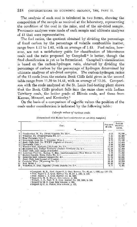
318 CONTRIBUTIONS TO ECONOMIC GEOLOGY, 1906, PAET II.
The analysis of each coal is tabulated in two forms, showing the composition of the sample as received at the laboratory, representing the condition of the coal in the mine, and of the air-dried sample. Proximate analyses were made of each sample and ultimate analyses of 13 that were representative.
The fuel ratios, the quotient obtained by dividing the percentage of fixed carbon by the percentage of volatile combustible matter, range from 1.12 to 1.61, with an average of 1.43. Fuel ratios, how ever, are not a satisfactory guide for classification of bituminous coals and the ratio proposed by Campbell a is better, though the final classification is yet to be formulated. Campbell's classification is based on the carbon-hydrogen ratio, obtained by dividing the percentage of carbon by the percentage of hydrogen determined by ultimate analyses of air-dried samples. The carbon-hydrogen ratios of the 13 coals from the eastern Book Cliffs field given in the second table range from 11.39 to 14.41, with an average of 12.96. Compari son with the coals analyzed at the St. Louis fuel-testing plant shows that the Book Cliffs product falls into the same class with Indian Territory coals, the better grade of Illinois coals, and those from Kansas, Missouri, and Kentucky. 6
On the basis of a comparison of cajorific values the position of the coals under consideration is indicated by the following table:
Calorific values of various coals.
[Determined with Mahler bomb calorimeter on air-dried samples.]
1?3450789
10 111?13141516
Coal.
Near Durango, Colo. d .........................................................
Book Cliffs field, No. XXXV (highest of 13 tests) ..............................
McAllister bed, Indian Territory (Indian Territory No. 3) c. ..................Book Cliffs field (mean of 13 tests) ............................................American Fuel Co., Gallup, N. Mex. (subbituminous) (New Mexico No. !)<=...
Belleville field, Illinois (Illinois No. 4) c ........................................
Belt, Mont, g ..................................................................Williston, N. Dak. (lignite) (North Dakota No. 2) c...........................
Per cent of ash.
4.037.415.313.726.255.09
12.6411.288.697.10
16 9911.8519.47
. 26.2620.886.71
British thermal units.
15,19014, 49913,81013, 44913, 41913,39412,95812, 46912, 16111, 435 11, 18210,99110,85210, 36410,1399,491
a Campbell, M. R., Prof. Paper U. S. Geol. Survey, No. 48, pt. 1,1906, pp. 156-173.b Prof. Paper U. S. Geol. Survey No. 48, pt. 1, 1906, p. 169.c Prof. Paper U. S. Geol. Survey No. 48, 1906.d Report by M. K. Shaler, this volume, p. 423.e Veatch, A. C., Bull. U. S. Geol. Survey No. 285, 1906, p. 339./Report by H. S. Gale, this volume, p. 300.9 Report by C. A. Fisher, this volume, p. 171.
BOOK CLIFFS COAL FIELD, COLOKADO-TJTAH. 319
The results were all obtained in the fuel-testing laboratory at St. Louis on air-dried samples of coal. Percentages of ash are also inserted in the table, for ash is so much inert matter and the calorific values would be misleading without a knowledge of its amount. As an illus tration, recalculation on an ash-free basis of coals from the Book Cliffs field, Nos. 5 and 13 in the above table, gives, respectively, 14,310 and 13,475 British thermal units. On such a basis the values for the coals from Belt, Mont., and Cambria, Wyo. (Nos. 15 and 14), which contain considerable ash, would be much increased. The coal from Frontier, Wyo. (No. 4), ranks high because of its small ash content.
No systematic tests have been made of the coking quality of the coals in the eastern part of the Book Cliffs field, although attempts have been made to coke the Cameo and Palisades coals, but thus far with poor results. On the other hand, the coal from the Sunnyside mine, at the west end of the area under discussion, is coked. It remains to be determined what coals in this field will coke and what will not. It should be. noted in this connection that whether a given coal will coke or not depends largely on the methods used. Coals which have been considered noncoking have been coked under proper treatment.
To judge from the analyses, therefore, the Book Cliffs coals are medium-grade bituminous and compare favorably with the product from the Rocky Mountain region and the Mississippi Valley.
DEVELOPMENT.
Very little has been done in developing this area. There are only four mines with railroad connection and practically their entire product is used by the towns of Grand Junction, Palisades, and Fruita, and by the Uinta Railroad. These mines are the Cameo (No. 1), Palisades (No. 6), Book Cliff (No. 10), and Carbonera (No. 26).' They are reported to have,produced in 1905 a total of only 50,000 tons; the other mines shown on the map are for the most part country banks that yield a few hundred tons each year. At present the local market is the only outlet, but with the equalization of freight rates on the Denver and Rio Grande Railroad, which extends along the' O
lowland at the base of the Book Cliffs, it probably will not be long before this great coal reserve will be more actively developed.
9411 Bull. 316-07 21
320 CONTRIBUTIONS TO ECONOMIC GEOLOGY, 1906, PART II.
The following is a list of the mines and prospects in this area, numbers correspond to those used on the map (PI. XVIII).
The
1. Cameo mine.2. Prospect on upper coal.3. Mount Lincoln mini \4. Riverside mine.5. Prospect on upper coal.6. Palisades mine.7. Garfield mine.8. Prospect on lower coal.9. Old Book Cliff mine.
10. Book Cliff mine.11. Keystone or Steele mine.12. Black Diamond mine.13. Farmer's mine.14. Bob Cat mine.15. Excelsior mine.16. Corcoran mine.17. Hunter mine.18. Kiel or Gross mine.
19. Nugent mine.20. Nearing mine.21. Mott prospect.22. Johnson mine.23. Lane mine.24. Prospect.25. Prospect.26. Uinta Railroad Company's mine.27. Coal outcrop.28. Coal outcrop.29. Prospect.30. Ballard mine.31. Black Baby mine.32. Petersen's prospect.33. Prentiss prospect.34. Prentiss prospect.35. Horse Canyon mine.
THE DURANGO COAL DISTRICT, COLORADO.
By JOSEPH A. TAFF.
INTRODUCTION.
The geology and coal resources of the Durango district are gener ally well known. Reconnaissance surveys were made through the eastern part of the district in 1905 and through the western part in1906, in the progress of a survey of the Durango-Gallup coal field. Reports of this reconnaissance work are found in the Contributions to Economic Geology for 1905 and 1906. a
During September and October, 1906, the writer had occasion to map the base of the coal-bearing strata of the Mesaverde formation between Florida and Mancos rivers and the base of the Laramie for mation from Animas to Florida River. This mapping was done by stadia measurements, a.method that permits an'accuracy of loca tion both of coal areas and of mines and prospects that is not obtain able by more rapid reconnaissance methods.
The chief purposes in presenting this paper simultaneously with the report of reconnaissance surveys are to publish the map showing accurately the boundaries of the coal land and to discuss more fully the development of the coals.
TOPOGRAPHY.
The country indicated by the map (PI. XIX) as the Durango dis-< trict lies just off the southern foothills of the San Juan and La Plata mountains. The uplifts of these mountains have tilted the rocks' steeply toward the south along the northern border of the area. Far ther south, toward the center of the Durango-Gallup basin, the tilt ing of the rocks grows gradually less.
In general conformity with the southward tilting of the strata there is a corresponding but lower incline of the land surface. Along the southern foothills of the mountains there is a steeply inclined plain underlain and controlled in its northern part by the Dakota sand stone. This plain grows gradually narrower toward the east with
aSchrader, F. C., The Durango-Gallup coal field of Colorado and New Mexico: Bull. U. S. Geol. Survey No. 285 1900, pp. 241-258. Shaler, M. K., A reconnaissance survey of the western part of the Durango-Gallup coal fleld, this bulletin, pp. 37G-42G.
321
322 CONTRIBUTIONS TO ECONOMIC GEOLOGY, 1906, PART II.
the increasing steepness of the dip of the rocks. It extends over .the edge of the Mancos shale with gradually decreasing slope south ward to the base of the Mesaverde escarpment. This escarpment is made by the outcropping edge of the Mesaverde sandstone, which includes the lowest group of workable coal beds in the district. The position of the crest of the escarpment is shown on the map by the line indicating the outcrop of the lowest workable coal bed. A second broad plain slopes southward from the top of the Mesaverde scarp, its southern limit being the escarpment formed by the outcrop of the Laramie sandstone. The rocks gradually increase in dip toward the east through the Durango district, and there is a corresponding increase in the slope of this plain in the same direction.
The Laramie escarpment, which is similar to that of the Mesa verde, is located on the map by the line designating the outcrop of the lowest workable Laramie coal bed. This escarpment is due to the outcrop of the Laramie sandstones. The Lewis shale crops out below the Laramie on the north, making steep slopes beneath the sandstone cliffs. On the south "side of the scarp the slopes are more gradual, yet steep, and beyond the sandstones softer rocks make extensive flat areas.
The larger streams, Animas and La Plata rivers, flow southward across the escarpments and intervening plains with little change of grade. The valleys are relatively narrow and deep at the crossing of the escarpment ridges. Through plains of soft strata they are wider and more shallow, yet the sides are steep.
The two outliers, Perrine Peak and Barnroof Point, in the northern part of T. 35 N., Us. 9 and 10 W., are mesas capped by Mesaverde sandstone. The cliffs are high and in places impassable, especially on the north and east.
A considerable part of the Dolores Plateau to the north of the coalarea contains forests of pine. There are also considerable growths of merchantable pine on the rougher sandstone surfaces of the Mesa verde northwest of Porter, toward the head of Hay Gulch, on the borders of Cherry Creek Canyon, and on branches of East Canyon southeast of Mancos. Elsewhere in this district the vegetation con sists of pinon, juniper, scrub oak, and various other kinds of brush.
STRATIGRAPHY.
There are two formations of coal-bearing rocks in the Durango district the Laramie and the Mesaverde. Each consists of sand stone, shale, and coal, and each has an aggregate thickness of several hundred feet. The coal beds occur in the midst of and interbedded with the sandstone and shale. The Laramie formation is the younger, but both are of Cretaceous age.
Massive white sandstone beds lie just below the lowest workable coal beds in the Laramie. This sandstone makes cliffs in the ridges and escarpments and forms a pronounced feature of the landscape..
DURANGO COAL DISTRICT, COLORADO. 323
The mammoth coal bed once mined at Carbon Junction and the beds of the abandoned La Plata mine southeast of Durango lie just above this massive sandstone. Sandstone beds interstratified with shale occur above the workable coal beds of the Laramie for a distance of several hundred feet.
The Laramie is separated from the Mesaverde formation below by the Lewis shale, 1,600 feet thick. This shale makes broad stretches of flat country between the basal boundary lines of the Laramie and Mesaverde coals shown on the map.
The Mesaverde formation has in its upper part pronounced sand stone layers interbedded with shale and some thin coal beds. A cen tral member consists of shale, beds of workable coal, and sandstone. The shale or shaly beds on the whole are more pronounced than the sandstone strata. There are three and in places four workable beds of coal in this central part of the Mesaverde. Very near and belowthe workable coal beds there are thick whitish sandstone beds com parable to the thick white sandstone in the lower part cif the Laramie . formation. These sandstone beds show in almost continuous outcrops that are unfailing keys to the presence of the coal beds. Below the thick sandstone there is a gradation through successively thinner sandstone layers down to the Mancos shale. The Mesaverde forma tion has a total thickness of nearly 1,000 feet.
The Mancos shale, underlying the Mesaverde, is about 1,200 feet thick. Like the Lewis shale, the Mancos is soft rock. It putcrops in valley and plateau lands north of the Mesaverde escarpment. It is underlain by the Dakota sandstone, which contains locally workable coal beds. In the area mapped, however, the coal is not known to be of any value and is not considered in this report.
STRUCTURE.
FOLDS.
All the coal-bearing rocks in the Durango district are tilted down ward toward the south and southeast. The dip of the rocks varies from place to place, increasing northward toward the mountains and also eastward along the outcrop of the formations. In the western part of the district the dip is fairly regular, 4° to 5° toward the south. In the vicinity of Hesperus, near the northern outcrop of the Mesa verde coals, the dip is nearly 8°. Within a few miles to the south the dip diminishes to 4° and continues with slight decrease down Hay Gulch to La Plata River. Local warping of the strata between Durango and Hesperus has produced lower southward dips of the rocks near the outcrop of the Mesaverde coals. The dips increase gradually eastward from 6° near Porter to 40° on Florida River 6 miles northeast of Durango.
The rocks in the central part of T, 35 N., R. 10 W., have been warped into a very shallow fold 2 to 3 miles in width, which is tilted
324 COSTTBIBUTIONS TO ECONOMIC GEOLOGY, 1906, PAKT II.
slightly toward the southwest. The Perrine Peak mine, near the north si'de of sec. 14, T. 35 N., R. 10 W., is in the central part of this fold. Farther east by way of Durango the dip changes to southeasterly and gradually increases, finally attaining an angle of 36° to 40° near the eastern boundary of the area mapped.
In the southeastern part of the district, in a belt of country gener ally following the outcrop of the Laramie coals, the rocks are tilted to the southeast at a slightly greater angle than farther west. By reference to the map it will be seen that the dips change gradually along the Laramie coal outcrop, from 8° at the southern edge of the area to 45° on Florida River.
FAULTS.Only a few faults have been observed in this district, and gener
ally they are too small to interfere seriously with the mining of coal. The rocks are exposed so extensively that faults of large amount would be detected. In the Durango district there are two kinds of
normal or tension faults. One is the ordinary type, in which the rocks on one side have been dropped'down with respect to those on the other side along a nearly vertical plane of fracture; in the faults of the other type the plane of movement is nearly horizontal.
Two faults of the first class occur near Durango. One is just west of the Gold King mine, in the northeast corner of sec. 32, T. 35 N., R. 9 W. This fault crosses the gulch in a northerly direction and has a throw of about 60 feet. Another fault of this class occurs in the west ern part of the Gold Prince mine, in the NE. J sec. 31, T. 34£ N., R. 9 E. This fault bears in a northeast direction and has thrown the rocks down toward the southeast. It has been overcome in the mine, however, and mining continued west of it. Several small faults are encountered in the mines at Porter and at Perrine Peak. None of these, however, have
. displaced the rocks more than a few feet. Three faults were noted in* the Hesperus mine, bearing N. 20° W. The greatest displacement
observed was 33 feet.Tension faults of the other class were noted in the cliffs near the
north end of the Perrine Peak mesa, in sec. 11, T. 35 N., R. 10 W. In these faults the plane of fracture is nearly horizontal, and the rocks above the break appear to have moved northward with respect to the rocks below. The displacement in all cases is slight and would not seriously affect coal-mining operations.
COALS.
LARAMIE COAL.
There are two grades of coal in the Durango district. One occurs in the upper or Laramie formation and the other in the Mesaverde formation. The location of the lowest workable bed in the Laramie is shown on the map. This coal, of which there are several beds, is of medium to low grade. It is classed as subbituminous coal (black
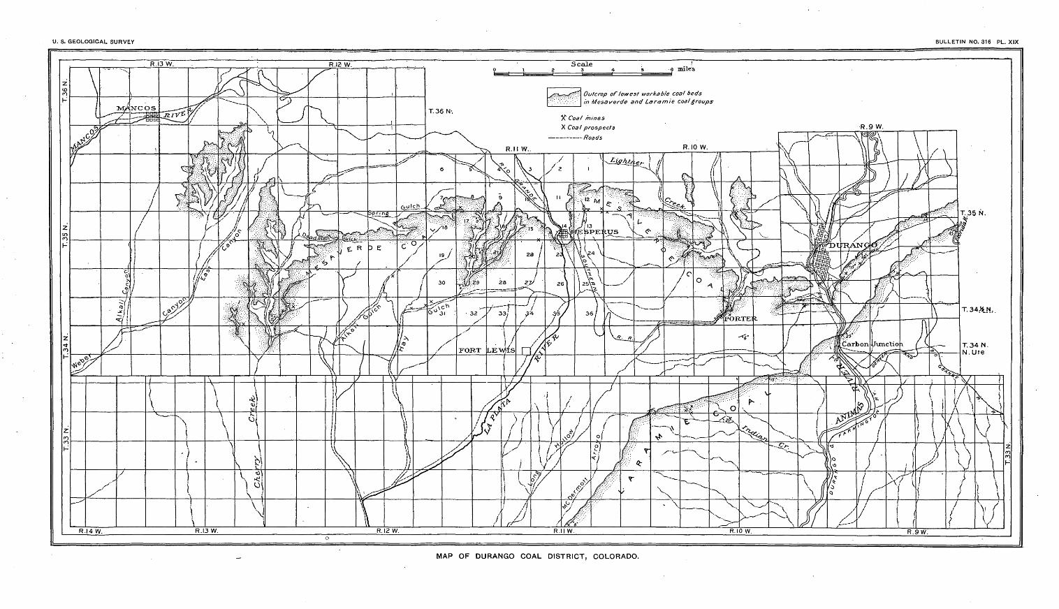
U. S. GEOLOGICAL SURVEY BULLETIN NO. 316 PL. XIX
Outcrop of lowest workable coal beds in Mesacerde and Laramie coal groups
X Coal mines
X Coal prospects - Roads
MAP OF DURANGO COAL DISTRICT, COLORADO.
/ DURANGO COAL DISTRICT, COLORADO. 325
T lignite). It is dull black in color and softer than the ordinary bitu-! minous coal, but like that grade it mines in cubical or block form.i When exposed to the weather for a considerable time it gives out1 and reabsorbs more moisture under varying conditions of the atmos
phere than the coals of higher grade, and will finally slack, the blocks' breaking down into small lumps or particles. It is considerably
lighter than the better bituminous coals, and when fired in the loco motive a large part of the smaller fragments of coal are driven out in the blast. Moreover, a considerable percentage will pass through
i the grates that are used in burning bituminous coal of better grades, owing to its softness and tendency to slack. The Laramie coals in this region contain many partings of shale or bone. This is espe cially true of the lower and thicker of the workable beds. In mining,
< these partings can not be entirely eliminated from the marketable coal. Certain variable and thin bony streaks also are an inseparablepart of the coal bed and give it a high percentage of ash. Coals of this class, however, mined in the region of Sheridan, Wyo., are used
' very extensively and successfully by locomotives with specially con-; structed grates.
J5 The coals of the Laramie formation have been mined to a con-/ siderable extent in sec. 27, T. 35 N., R. 9 W.; at Carbon Junction, in; sec. 4, T. 34 N., R. 9 W., 3 miles south of Durango, and to a smaller
extent at a number of other localities in the Durango district. None('' of the beds are worked at present, however, on account of the abun-'. dance of better coal in this district.
MESAVERDE COAL.
; The other class of coal in the Durango district occurs in the Mesa- verde formation. The outcrop of the lowest workable bed in this
formation and also all the mines and prospects on the different beds '. occurring in the formation are shown on the map. It is known that ;. there are three and in places four workable coal beds in the Mesaverde i formation. The coals in the different beds vary in quality slightly
from place to place. The beds that have been mined for a number of \ years at Porter are the best of this class that are known in the district. i They carry a good grade of coking coal, which is coked at Porter and < Durango. The coke is utilized chiefly for smelting purposes. : The coal that is mined at Hesperus can not be coked successfully / by the methods in use at present, but it is reported to have been
coked under more favorable conditions. All the coals, however, that ; are mined at present at Durango, Porter, Perrine Peak, Hesperus, ; and in the vicinity of Mancos are high-grade bituminous coals, and i are classed as excellent fuels for locomotive and domestic use. The ' coal mines in cubical or block form, but some of it is reported to pro
duce considerable slack. This slack, however, is converted into coke i or is -utilized in stationary engines and for domestic purposes.
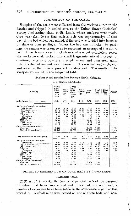
326 CONTRIBUTIONS TO ECONOMIC GEOLOGY, 1906, PAET II.
COMPOSITION OF THE COALS.
Samples of the coals were collected from the various mines in the district and shipped in sealed cans to the United States Geological Survey fuel-testing plant at St. Louis, where analyses were made. Care was taken to see that each sample was representative of that part of the bed which was mined, if the coal was divided into benches by shale or bone partings. Where the bed was unbroken by part ings the sample was taken so as to represent an average of the entire bed. In each case a section of clean coal was cut completely across the workable coal, broken into small fragments, mixed thoroughly, quartered, alternate quarters rejected, mixed and quartered again until the desired amount was obtained. This was inclosed in the can and sealed in the mine or prospect for shipment. The results of the analyses are stated in the subjoined table:
Analyses of coal samples from Durango district, Colorado.
[F. M. Stanton, chief chemist.]
Locality.
Labor
Analy
ot*Pn
P
Calori Ca Bi
Loss c
Analy
g<H *
+i
V
Calori Ca Bi
sis of sample as received:
Fixed carbon ................. (Ash..........................
Carbon .......................
O"VVf?PTl
5c value determined:
f moisture on air drying. .....
sis of air-dried sample:
Volatile matter. ..............
/Ash.... ......................ASulphur.....................
Carbon.......................
Qc value determined:
itish thermal units ...........
Three miles north west
of Du rango.
3552.
3. 6437.79 53. 35 5.22 1. 36 5.39
75. 40 1. 48
11.15
7,55313,595
1.60
2.07 38.40 54.22 5.31
5 9976. & 1.509.89
7,676 13,816
Near Duran
go.
4174.
2.70 32.75 59.82 4.73 .69
1.70
1.02 33. 32 60.86 4.81 .70
Three miles south east of Duran
go.
3551.
3. 05 32.70 47.47 16. 78 1.30 4.73
64.21 1.43
11.55
0,61111,900
.90
2.17 33.00 47.90 16.92 1.31 4.67
64.79 1.45
10.85
6,671 12,008
Near Duran
go-
4113.
1.41 33. 27 55. 97 9.35.58
.40
1.01 33. 40 56.20 9.38 .58
Hes perus.
7573.
5. 55 36. 23 52. 53 5.69
' .64 5.46
72.70 1.37
14.14
7,28913,120
2.30
3.33 37.08 53. 77 5.82
.66 5.32
74.41 1.40
12.39
7,461 13,429
Near Man- cos.
4225.
5. 44 38.71 50.10 5.75 1.01 5.80
72.26 1.47
13.71
7,17012.906
2.00
3. 51 39. 50 51.12 5.87 1.03 5.69
73. 73 1.50
12.18
7,316 13,103
Near Man- cos.
3991.
6.12 35. 86 49.44 8.58 .63
2.50
3.71 36.78 50. 71 8.80
.64
........
Porter.
2092.
2.7330. 65 54.48 6.74 .53
7,730 13,914
1.30
2.46 37.13 55.19 6.82 .54
DETAILED DESCRIPTION OF COAL BEDS BY TOWNSHIPS.
LARAMIE COAL.
T. 35 N., R. 9 W. Of the two principal coal beds of the Laramie formation that have been mined and prospected in the district, a number of exposures have been made in the southeastern part of this township. A small mine was located on one of these beds and con-
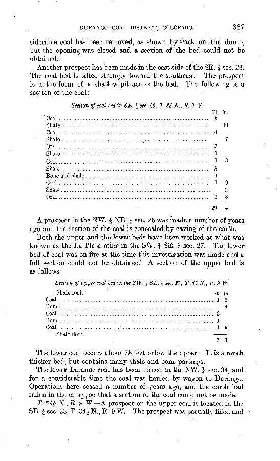
DURANGO COAL DISTRICT, COLORADO. 327
siderable coal has been removed, as shown by slack on the dump, but the opening was closed and a section of the bed could not be obtained.
Another prospect has been made in the east side of the SE. J sec. 23. The coal bed is tilted strongly toward the southeast. The prospect is in the form of a shallow pit across the bed. The following is a section of the coal:
Section of coal bed in SE. J sec. 23, T. 35 N.,R.9 W.Ft. in.
Coal ......................................................... 6Shale....................................................... 10Coal......................................................... 4Shale.......................':............................... 7Coal................................'........................ 3Shale....................................................... 1Coal.........................-......--.-..------------------ 1 3Shale ....................... i................................ 5Bone and shale.............................................. 4Coal........................................................Shale.......................................................Coal........................................................
.29 4
A prospect in the NW. J NE. J sec. 26 was made a number of years ago and the section of the coal is concealed by caving of the earth.
Both the upper and the lower beds have been worked at what was known as the La Plata mine in the SW. \ SE. \ sec. 27. The lower' bed of coal was on fire at the time this investigation was made and a full section could not be obtained. A section of the upper bed is as follows:
Section of upper coal bed in the SW. ^ SE. I sec. 27, T. 35 N., R. 9 W.
Shale roof. Ft. in. Coal.......................................................... 1 2Bone.......................................................... 4Coal.......................................................... 3Bone........................................................... 1Coal.......................-.................................. 1 9
Shale floor. 7 3
The lower coal occurs about 75 feet below the upper. It is a much thicker bed; but contains many shale and bone partings.
The lower Laramie coal has been mined in the NW. \ sec. 34, and for a considerable time the coal was hauled by wagon to Durango. Operations here ceased a number of years ago, and the earth had fallen in the entry, so that a section of the coal could not be made.
T. 34$ N., R. 9 W. A prospect on the upper coal is located in the SE. | sec. 33, T. 34£ N., R. 9 W. The prospect was partiaUy filled and
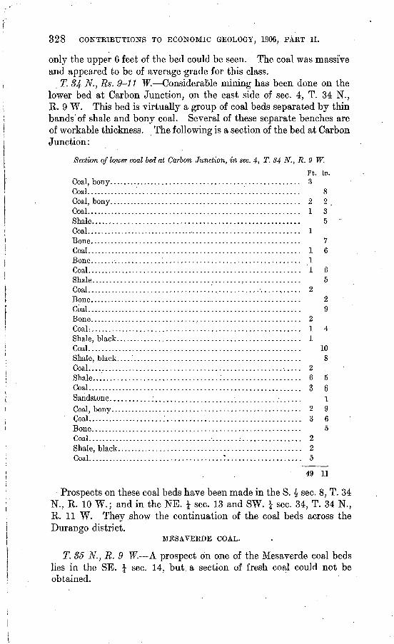
328 CONTBIBUTIONS TO ECONOMIC GEOLOGY; 1906, PAKT II.
only the upper 6 feet of the bed could be seen. The coal was massive and appeared to be of average -grade for this class.
T. 84 N., Rs. 9-11 W. Considerable mining has been done on the lower bed at Carbon Junction, on the east side of sec. 4, T. 34 N., R. 9 W. This bed is virtually a group of coal beds separated by thin bands of shale and bony coal. Several of these separate benches are of workable thickness. The following is a section of the bed at Carbon Junction:
Section of lower coal bed at Carbon Junction, in sec. 4, T. 34 N., R. 9 W.
Ft. in. Coal, bony..................................................... 3Coal.............. '.. .......................................... 8Coal, bony.................................................... 2 2 .Coal................................!......................... 1 3Shale.........:.............................................. 5 °Coal............................................................ 1Bone......................................................... 7Coal.......................................................... 1 6Bone......................................................... 1Coal.......................................................... 1 6Shale........................................................ 5Coal..................................'.,...........-.....,..... 2Bone...................................................... t ... 2Coal.......................................................... 9Bone......................................................... 2CoaL......................................................... 1 4Shale, black.................................................. 1Coal.......................................................... 10Shale, black.................................................. 8Coal.......................................................... 2 .Shale..................................:..................... 6 5Coal.......................................................... 3 6Sandstone...........:....................................... 1Coal, bony.................................................... 2 9Coal.....................:..................................... 3 6Bone......................................................... 5Coal.......................................................... 2Shale, black................................................... 2Coal......:..............................:.................... 5
49 11
Prospects on these coal beds have been made in the S. £ sec. 8, T. 34 N., R. 10 W.; and in the NE. J sec. 13 and SW, £ sec. 34, T. 34 N., R. 11 W. They show the continuation of the coal beds across the Durango district.
MESAVERDE COAL.
T. 85 N.,E. 9 W. A prospect on one of the Mesaverde coal beds lies in the SE. \ sec. 14, but a section of fresh coal could not be obtained.
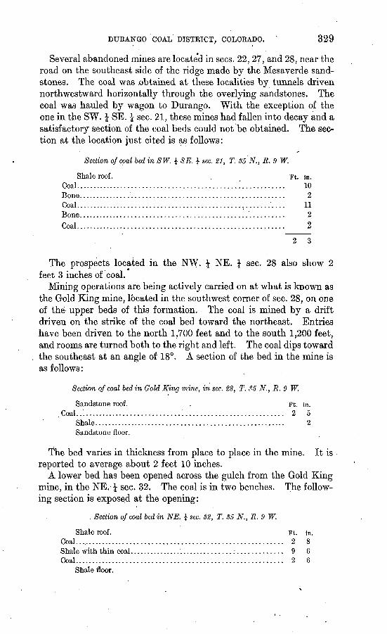
DUEANGO COAL DISTEICT, COLOEADO. x 329
Several abandoned mines are located in sees. 22, 27, and 28, near the road on the southeast side of the ridge made by the Mesaverde sand stones. The coal was .obtained at these localities by tunnels driven northwestward horizontally through the overlying sandstones. The coal was hauled by wagon to Durango. With the exception of the one in the SW. f SE. I sec. 21, these mines had fallen into decay and a satisfactory section of the coal beds could not be obtained. The sec tion at the location just cited is as follows:
Section of coal bed in SW. J SE. J sec. 21, T. 35 N., R. 9 W.
Shale roof. Coal...............................Bone. .............................Coal...............................Bone. .............................Coal...............................
Ft. In. .............. ............. 10........................... 2........................... 11
2
........................... 2
The prospects located in the NW. \ NE. \ sec. 28 also show 2 feet 3 inches of coal.
Mining operations are being actively carried on at what is known as the Gold King mine, located in the southwest corner of sec. 28, on one of the upper beds of this formation. The coal is mined by a drift driven on the strike of the coal bed toward the northeast. Entries have been driven to the north 1,700 feet and to the south 1,200 feet, and rooms are turned both to the right and left. The coal dips toward the southeast at an angle of 18°. A section of the bed in the mine is as follows:
Section of coal bed in Gold King mine, in sec. 28, T. 35 N., R. 9 W.
Sandstone roof. - Ft. in. . Coal..'............................'............................ 2 5
Shale...................................................... 2Sandstone floor.
The bed varies in thickness from place to place in the mine. It is reported to average about 2 feet 10 inches.
A lower bed has been opened across the gulch from the Gold King mine, in the NE. £ sec. 32. The coal is in two benches. The follow ing section is exposed at the opening:
Section of coal bed in NE. $ sec. 82, T. 35 N., R. 9 W.
Shale roof. Ft. in. Coal.......................................................... 2 8Shale with thin coal.......................................;.... 9 6Coal.......................................................... 2 6
Shale floor.
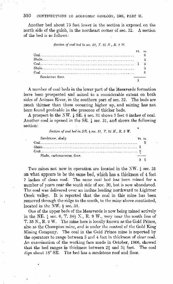
330 CONTKIBUTIOlSrS TO ECONOMIC GEOLOGY, 1906, PAKT II.
Another bed about 75 feet lower in the section is exposed on the north side of the gulch, in the northeast corner of sec. 32. A section of the bed is as follows:
Section of coal bed in sec. 32, T. 35 N., R. 9 W.
Ft. in.Coal.......................................................... 6Shale........................................................ 4Coal.......................................................... 1 3Shale........................................................ 5Coal ......................................................... 6
Sandstone floor.
A number of coal beds in the lower part of the Mesaverde formation have been prospected and mined to a considerable extent on both sides of Animas River, in the southern part of sec. 32. The beds are much thinner than those occurring higher up, and mining has not been found profitable in the presence of thicker beds.
A prospect in the NW. J SE. J sec. 31 shows 3 feet 6 inches of coal. Another coal is opened in the SE. £ sec. 31, and shows the following section:
Section of coal bed in SE. | sec. 31, T. 35 N., R. 9 W.
Sandstone, shaly. Ft. in. Coal............................................................ 5Shale. ......................................................... 1Coal............................................................ 2
Shale, carbonaceous, floor. 3 5
Two mines not now in operation are located in the NW. £ sec. 31 on what appears to be the same bed, which has a thickness of 4 feet7 inches of clean coal. The same coal bed has been mined for a number of years near the south side of sec. 30, but is now abandoned. The coal was delivered over an incline leading northward to Lightner Creek valley. It is reported that the coal in this mine has been removed through the ridge to the south, to the mine above mentioned, located in the NW. £ sec..31.
One of the upper beds of the Mesaverde is now being mined actively in the NE. J sec. 6, T. 34| N., R. 9 W., very near the south line of T. 35 N., R. 9 W. The mine here is locally known as the Gold Prince, also as the Champion mine, and is under the control of the Gold King Mining Company. The coal in the Gold Prince mine is reported by the operators to range between 3 and 4 feet in thickness of clear coal. An examination of the working face made in October, 1906, showed that the bed ranges in thickness between 2J and 3£ feet. The coal dips about 18° SE. The bed has a sandstone roof and floor.
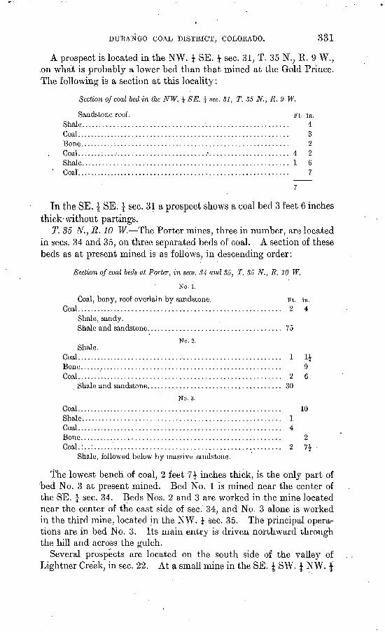
DURANGO GOAL DISTRICT, COLOEADO. 331
A prospect is located in the NW. \ SE. \ sec. 31, T. 35 N.; K. 9 W., .on what is probably a lower bed than that mined at the Gold Prince. The following is a section at this locality:
Section of coal bed in the NW. J SE. 1 sec. 81, T. 35 N., R. <J W.
Sandstone roof. Ft. in.Shale......................................................... 4Coal........................................................... 3Bone..........:............................................... 2
. Coal.......:............................/...................... 4 . 2Shale......................................................... 1 6
' Coal........................................................... 7
In the SE. J SE. \ sec. 31 a prospect shows a coal bed 3 feet 6 inches thick-without partings.
T. 85 N., R. 10 W. The Porter mines, three in number, are located in sees. 34 and 35, on three separated beds of coal. A section of these beds as at present mined is as follows, in descending order:
Section of coal beds at Porter, in sees. 84 and 85, T. 35 N., R. 10 W.
No. i.
Coal, bony, roof overlain by sandstone. Ft. in. Coal.......................................................... 2 4
Shale, sandy.Shale and sandstone..................................... 75
No. 2. .Shale.
Coal.......................................................... 1 IJBone........................................................ 9Coal......................................................... 2 6
Shale and sandstone......................... 1........... 30
No. 3. Coal......................................................... 10Shale....................................................... 1Coal......................................................... 4Bone........................................................ 2Coal.:..:.................................................... 2 7$
Shale, followed below by massive sandstone.
The lowest bench of coal, 2 feet 1\ inches thick, is the only part of bed No. 3 at present mined. Bed No. 1 is mined near the center of the SE. | sec. 34. Beds Nos. 2 and 3 are worked in the mine located near the center of the east side of sec. 34, and No. 3 alone is worked in the third mine, located in the NW. \ sec. 35. The principal opera tions are in bed No. 3. Its main entry is driven northward through the hill and across the gulch.
Several prospects are located on the south side of the valley of Lightner Creek, in sec. 22. At a small mine in the SE. J SW. \ NW. J
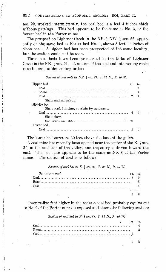
332 CONTRIBUTIONS TO ECONOMIC GEOLOGY, 1906, PAKT II.
sec. 22, worked intermittently, the coal bed is 4 feet 4 inches thick without partings. This bed appears to be the same as No. 3, or the lowest bed in the Porter mines.
The prospect on Lightner Creek in the NE. J NW. | sec. 22, appar ently on the same bed as Porter bed No. 3, shows 5 feet 11 inches of clean coal. A higher bed has been prospected at the same locality, but the section could not be seen.
Three coal beds have been prospected in the forks of Lightner Creek in the NE. £ sec. 21. A section of the coal and intervening rocks is as follows, in descending order:
Section of coal beds in NE. J sec. 21, T. 35 N., R. 10 W.
Upper bed: Ft. in. Coal...................................................... 7
- Shale.................................................... 7Coal...................................................:.. 2 7
Shale and sandstone. Middle bed:
Shale roof, 6 inches, overlain by sandstone. Coal...................................................... 4 9
Shale floor.Sandstone and shale.................................... 80
Lower bed:Coal...................................................... 2 3
The lower bed outcrops 30 feet above the base of the gulch.A coal mine has recently been opened near the center of the E. £ sec.
21, in the east side of the valley, and the entry is driven toward the east. The bed here appears to be the same as No. 3 of the Porter mines. The section of coal is as follows:
Section of coal bed in E. \ sec. 21, T. 35 N., R. 10 W.i
Sandstone roof. Ft. in.Coal. ............................................................. 3 9Bone.......................................................... 5Coal........................................................... 4
4 6\
Twenty-five feet higher in the rocks a coal bed probably equivalent to No. 2 of the Porter mines is exposed and shows the following section:
Section of coal bed in E. \ sec. 21, T. 35 N., R. 10 W.
Ft. in. Coal.........,...............;...................,............. 4Bone.......................................................... 2Coal..............................................1 ............. 1
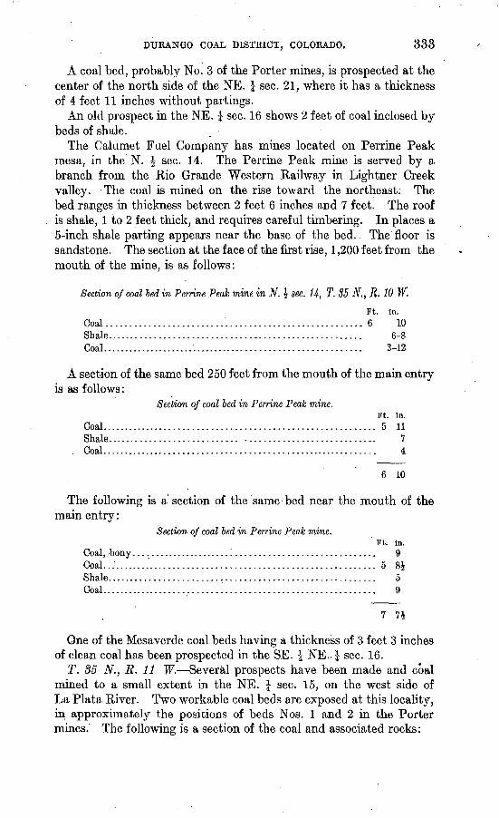
DURANGO COAL DISTRICT, COLORADO. 333
A coal bed, probably No. 3 of the Porter mines, is prospected at the center of the north side of the NE. | sec. 21, where it has a thickness of 4 feet 11 inches without partings.
An old prospect in the NE. J sec. 16 shows 2 feet of coal inclosed by beds of shale.
The Calumet Fuel Company has mines located on Perrine Peak mesa, in the N. \ sec. 14. The Perrine Peak mine is served by a branch from the Rio Grande Western Railway in Lightner Creek valley. -The coal is mined on the rise toward the northeast; The bed ranges in thickness between 2 feet 6 inches and 7 feet. The roof is shale, 1 to 2 feet thick, and requires careful timbering. In places a 5-inch shale parting appears near the base of the bed. The floor is sandstone. The section at the face of the first rise, 1,200 feet from the mouth of the mine, is as follows:
Section of coal bed in Perrine Peak mine in N. \ see. 14, T. 35 N., R. 10 W.
Ft. in.Coal........ ; ............................................. 6 10Shale...................................................... 6-8Coal.......................................................... 3-12
A section of the same bed 250 feet from the mouth of the main entry is as follows:
Section of coal bed in Perrine Peak mine.
Coal...............................Shale............................Coal...............................
Ft. in. ............................ 5 11............................ 7............'................. 4
6 10
The following is a section of the same bed near the mouth of the main entry:
Section of coal bed in Perrine Peak mine.Ft. in.
Coal, bony..................................................... 9Coal........................................................... 5 8iShale......................................................... 5Coal. .........................i................................ 9
One of the Mesaverde coal beds having a thickness of 3 feet 3 inches of clean coal has been prospected in the SE. J NE- J sec. 16.
T. 35 N., R. 11 W. Several prospects have been made and coal mined to a small extent in the NE. J sec. 15, on the west side of La Plata River. Two workable coal beds are exposed at this locality, in approximately the positions of beds Nos. 1 and 2 in the Porter mines. The following is a section of the coal and associated rocks:
334 CONTRIBUTIONS TO ECONOMIC GEOLOGY, 1906, PART II.
Section of coal beds in NE. I sec. 15, T. 35 N., R. 11 W.
Sandstone, shaly. Ft. in.Coal..............:........................................... 3 .Shale........................................................ 4Coal.......................................................... 3 9Shale.........................;................................ 10Coal.......................................................... 1 9Shale........................;............................... 3Coal.......................................:.................. 6
Shale and sandstone...................................... 75Coal........... ........................ ....................... 8
Shale.................................................... 8Coal.......................................................... 2 6
Shale.................................................... 6Sandstone, thick.
One of the lower beds in the Mesaverde formation has been mined extensively on the east side of the La Plata in the NE. \ sec. 14. These mines were abandoned, apparently for more favorable loca tions at Hesperus, in the southern part of the same section. They have fallen by decay, but the section at the main entry is shown asfollows:
Section of coal beds in NE. % sec. U, T. 35 N., R. 11 W.
Sandstone, shaly. Ft. in. Coal exposed (lower part of bed concealed)...................... 5
Shale and sandstone...................................... 100Shale roof to coal.
Coal.......................................................... 6Bone......................................................... 3Coal......................................................:... 6 2
Sandstone.
One of these beds has been mined extensively near the south edge of sec. 12, in what is known as the Ute mine. Operations had ceasedat this mine when an investigation of the coal was made, but the bed appears to correspond to No. 1 or No. 2 of the Porter section. The following is the section of the coal at the Ute mine:
Section of coal bed at Ute mine, sec. 12, T. 35 N., R. 11 W.Ft. in.
Sandstone, white, exposed................................. 20Shale roof.
Coal.........:................................................ 3 11Bone......................................................... 3Coal............:.............................................. 1 Q
Total coal bed.......................................... 5 2
One of the lower coal beds of the Mesaverde formation is worked actively at Hesperus, in what is known as the Hesperus mine, which is under the same control as the mines at Porter. The bed has an average thickness of about 5^ feet. Locally it runs as high as 6^ feet and as low as 4 feet 10 inches. It is mined by slope toward the west.
DURANGO COAL DISTRICT, COLORADO, 335
The coal dips 12° S. near the entrance and about 8° at the face of the main slope. The roof of the coal is generally sandstone, but a selvage of shale occurs locally between the sandstone and coal. The floor is sandstone, with a few inches of carbonaceous shale or bone at the base of the coal.
Some of the upper coal beds of the Mesaverde formation have been prospected and mined for local consumption in Hay Gulch, in sec. 31, T. 35 N., R. 11 W., and sec.. 36, T. 35 N., R. 12 W. One of these beds in the NW. J NW. J sec. 31 is 6 feet 8 inches thick and has a shaly sandstone roof. The same bed has been'mined in the NE. {* sec. 36, T. 35 N., R. 12 W.; but the operations are now abandoned and the coal is partially concealed, 2£ feet being exposed from the roof down ward. A prospect on what is probably the same bed is located in the SE. | NW. 1 sec. 36, T. 35 N., R. 12 W. A short drift 20 feet in length has been driven on the coal. The section here is as follows:
Section of coal bed in SE. £ NW. £ sec. 36, T. 35 N., R. 12 W.Sandstone. Ft. in.
Coal........................................................ 1Bone....................................................... 6Coal..................................:..................... 4
Sandstone............................................. 20-30
Total coal bed......................................... 5 6
The lower coal beds of the Mesaverde formation are exposed in natural outcrops in many places along the upper courses of Hay Gulch, in sees. 16, 17, 20, and 21, T. 35 N., R. 11 W. The crop of one of these coals in the NE. £ sec. 17 shows 4 feet of coal. A shallower prospect, located in the SW. \ SW. \ sec. 8, exposes 10 feet of coal apparently without any parting. The coal, however, is partially decomposed and its true character could not be determined.
T. 85 N., R. 12 W. Coal has been prospected on the east side of Alkali Gulch near the Crawford ranch. The bed has a sandy-shale roof and shows 3 feet 9 inches of coal.
A number of natural coal outcrops were noted on the east side of Cherry Creek valley. In the SE. \ sec. 31 a coal bed in the upper part of the Mesaverde formation is exposed in a prospect and shows the following section:
Section of coal bed in the SE. \ sec. 31, T. 35 N., R. 12 W.
Shale, white. ' Ft. in. Coal............................................................ 2Shale......................................................... 4Coal........................................................... 3Shale, black.. ..............'................................... 4Coal........................................................... 3Shale and coal................................................. 4Coal........................................................... 2 G
Shale. 6 11
9411 Bull. 316 07 22
336 CONTEIBUTIONS TO ECONOMIC GEOLOGY, 1906, PAKT II.
In the SE. £ NW. \ sec. 32, on the east side of Cherry Creek, ten different coal beds, two or three of which are workable, are exposed in a small gulch. The upper workable bed has the following section:
Section of coal bed in the SE. \ NW. J sec. 32, T. 35 N., R. 12 W.
Sandstone. Ft. in. Coal....................................................."...... 3.. 4Shale.......................................................... 1 3Coal........................................................... 1 10
6 5
About 100 feet lower in the section is another workable coal bed, which has the following section:
Section of coal bed in the SE. \ NW. J sec. 32, T. 35 N., E. 12 W.
Shale. Ft. in.Coal..........................................'-...............-.. 1 3Sandstone.................................................... 4Coal.......................................:................... 1 3
Shale. 2 10
Between the two beds above described there are two other beds in which the coal has a thickness of 2 feet. About 25 feet below the lower bed, whose section is given above, is another showing 2 feet of coal. All of the coal is weathered and a satisfactory interpretation of its quality can not be made.
T. 35 N., R. 13 W. Several coal beds in the Mesaverde formation are exposed and active milling has been carried on in the.W. § sec. 2, T. 35 N., R. 13 W. The mine now being worked, known as the Spencer mine, is located in the north face of the escarpment. An incline and" spur of the Rio Grande Southern Railroad is being con structed from Mancos and it is planned to mine a large quantity of coal in the near future. Previously the output was hauled from the mines to Mancos by wagon and shipped principally to Telluride. The coal from this mine is especially sought for domestic fuel. Two work able beds are exposed in the same locality by prospect above the Spencer coal. The following is a section of the three coal beds with intervening rocks:
Section of coal beds at Spencer mine.Shale.'
Coal, bony. ................................Coal.......................................Bone. .....................................Coal........................................
Sandstone and shale. ..................
Ft. in. .................. 1
"1 14
2.................. 1 11.................. 30
Shale. Coal......................................................... 3 3
Sandstone.............................................. 25Coal, Spencer bed........................................... 3 2
Shale.
DTJRANGO COAL DISTRICT, COLORADO. 337
Natural exposures of the coal beds in the Mesaverde formation are of common occurrence on the headwaters of the western branch of East Canyon, south and east of the Spencer mine. In all these exposures the coal is considerably decomposed and it was not pos sible to determine its character, though the sections indicated work able thickness. The same beds are exposed at a number of places in sec. 36, on a branch of Cherry Creek. There were no fresh exposures in this locality, but the showing made by the beds indicated workable coal.
T. 36 N., R. IS W What is believed to be the same bed that is worked at the Spencer mine has been recently opened in the NE. | sec. 36, at the 1 Wood mine. An entry about 100 feet in length has been driven on the coal at this place. The following section is shown at the face:
. Section of coal bed at Wood mine, in NE. \ sec. 36, T. 36 N., R. 13 W.
Shale and thin coal interstratified. t Ft. in.Coal. /.....................................'...............:.. 1 4Coal, shaly................................................... 5 5Coal.... I...................'................................. 3Bone.......................i................................. 6
THE PLEASANT VALLEY COAL DISTRICT, CARBON AND EMERY COUNTIES, UTAH.
By JOSEPH A. TAFF.
INTRODUCTION.
A reconnaissance survey of the Book Cliffs coal field in Carbon, Emery, and Sevier counties, Utah, was made by the writer in 1905. At the same time certain areas were surveyed more carefully for the purpose "of classification, but the time allotted did not permit an accurate limitation of the coal land as a whole or a thorough study of the structure of the rocks.
During the season from April to September, 1906, the outcrop of the lowest workable coal in the sectioned areas, of the same coal field were located by instrumental measurement and much additional information was gained regarding the character of the coal and the general structure of the rocks. The outcrop of the lowest workable coal was- mapped as accurately as the land surveys would permit. This outcrop marks the boundary of the coal land and is shown on the accompanying map (PL XX).
In the Book Cliffs proper, which extend eastward from the vicinity of Castlegate, the later surveys produced but little information addi tional to that obtained in the previous reconnaissance work. The coal-bearing measures are admirably exposed in the bold and, for the most part, bare escarpments of the Book Cliffs and in the eastern edge of the Wasatch Plateau. The geology is simple, the rocks being almost flat. In Pleasant Valley, however, near the north end of the Wasatch Plateau, and in Huntington Canyon, lying imme diately to the south, the surface features are smoother, especially in the more elevated parts, though deeply cut into canyons and gulches. Here the edges of the coal-bearing strata are concealed in a large measure by a mantle of soil and weathered rock. In addition, a more abundant growth of vegetation is found here than in the lower and more broken lands. The recent surveys in the Pleasant Valley district have added much to previous knowledge of the occurrence of coal and the faulted structure of the rocks.
338
PLEASANT VALLEY COAL DISTRICT, UTAH. 339
LOCATION.
The area here designated as the Pleasant Valley district lies at the junction of the Book Cliffs and the Wasatch Plateau. The coal- bearing strata are continuously exposed in the Book Cliffs from Castle- gate eastward into Colorado. They crop out also in the eastern escarpment of the Wasatch Plateau from the same locality southward for more than 60 miles into eastern Sevier County, where the coal field is interrupted by the igneous mass of Mount Hilgard.
The coal exposures in Pleasant Valley are an inlier in a local swell of the strata at the junction of the Book Cliffs and Wasatch plateaus.
The main line of the Rio Grande Western Railway crosses the coal- bearing rocks at Castlegate, just east of the Pleasant Valley district, and a branch connects the coal mines in Pleasant Valley with the main line at Colton.
TOPOGRAPHY.
The surface of the Pleasant Valley region exhibits three distinct types of topography. The most prominent of these is the bare and rugged escarpments of the Book Cliffs and Wasatch Plateau, 1,000 to 1,500 feet high. That of the Book Cliffs is continuous westward from Colorado and joins the scarp of the Wasatcrj. Plateau 12 miles west of Castlegate. It faces toward the south. The scarp of the Wasatch Plateau faces eastward and stretches to the south for 65 to 75 miles, coming to an end in eastern Sevier County. The coal measures crop out in the middle slopes of the Book Cliffs and Wasatch escarpments and in the sides of Pleasant Valley.
At the base of the Book Cliffs and Wasatch escarpments is a broad, rolling plain, open toward the south and east, known as Castle Valley, which lies 500 to 1,000 feet below the coal-bearing strata.
The third important topographic feature in this coal district is found above the outcrop of the coal-bearing rocks, the top of which usually lies a few hundred feet below the higher cliffs in the escarp ments. Back of these cliffs the surface is comparatively smooth to the top of the plateau. The crests of the ridges in the general plateau level are oval and undulating, and the upper courses of the valleys are shallow and smooth except where the divides approach the escarp ment. In such places the surfaces are steep and in places bluffy.
South of Pleasant Valley Huntington River has cut a deep gorge or boxlike canyon through the harder rocks associated with the coal and is now flowing on the soft shale of the underlying formation. The undercutting in the softer shale is responsible in a large measure for the precipitous character of the canyon walls. At the upper limit of the coal rocks the topography of Huntington Canyon changes from the abrupt, angular features of the box canyon to the oval though
340 CONTRIBUTIONS TO ECONOMIC GEOLOGY; 1906, PART II..
steep slopes of the higher parts of the Wasatch Plateau. Farther north, in T. 13 S., R. 6 E., the valley is comparatively shallow, wide, and smooth.
Similar topographic conditions prevail in Pleasant Valley, which is drained by West Fork of Price River. The valley is a deep, narrow gorge near its head, but grows gradually broader and natter, toward the north, and midway between Clear Creek and Scofield the bottom is flat. It broadens northward to a width of about 1 mile at Scofield. In T. 12 S., R. 7 E., it is a flat swampy plain and has a width of nearly 2 miles. In sec. 9 the river turns abruptly eastward, leaving the swampy plain, and enters a° narrow, sharp gorge, and so continues to Colton.
The hills and ridges rise gradually from Pleasant Valley in both directions. On the east the surface attains an elevation of about 1,000 feet above the valley, and on the west the slopes rise steeply to the same elevation and then more gradually to the crest of the divide between Pleasant Valley and Huntington Canyon. The altitude of this divide opposite Clear Creek is nearly 1,500 feet above the level of the valley and about 10,000 feet above the sea.
In this district, as well as throughout the coal field generally, the steeper and more barren slopes almost invariably are those that face toward the south and east. The prevailing winds are westerly, and the surfaces that face toward the west and north receive heavy falls of rain and snow. The surfaces that face southward receive the sun's rays more directly and consequently they are the more arid and are only slightly protected by soil and vegetation, forming in many places impassable cliffs hundreds of feet in height.
STRATIGRAPHY.
The coal beds of the Pleasant Valley district occur in a formation or group of strata consisting of sandstone and shale. The sandstone beds range in composition from almost pure white stone of moderate hardness to yellowish or brown argillaceous or shaly sandstone. Less is known of the composition and physical properties of the shale, for as a rule it crops out on slopes and is generally concealed by soil and talus. It ranges from clay shale to various grades of sandy shale. In the unweatliered state these beds are blue to black in color and are moderately soft. In proximity to the coal beds, usually immediately above, and at some other places where coal does not occur, the shale is carbonaceous. Except where active erosion is going on there is everywhere a mantle of clay and partially decomposed strata.
In the group of strata that contains the coal beds the volume of sandstone and shale is approximately equal, and the individual beds of each range from thin layers to strata that are as much as 100 feet thick. Just below the coal bed that is mined at Castlegate, in the
PLEASANT VALLEY COAL DISTKICT, UTAH. 341
lower part of the coal-bearing strata, there is a sandstone nearly 100 feet thick. The upper part is massive and light colored, but 50 to 80 feet below the top the bedding is more distinct, and farther down it grades into shaly sandstone, which is followed below by shale. A similar sandstone lies 150 to 180 feet below the Castlegate coal hori zon. The upper part is massive and white to buff colored. From the middle downward the sandstone becomes more argillaceous and distinctly stratified, grading down to shaly sandstone.
The coal-bearing strata, 600 to 800 feet thick, are overlain by light-buff sandstone that contains only here and there a stratum of shale. This sandstone is several hundred feet thick. It makes im- ,posing cliffs above the town of Castlegate, in the Price River canyon, and at many places elsewhere in the upper part of the Book. Cliffs and Wasatch Plateau escarpments. Still higher stratigraphically, sandstone and shale beds succeed each other until the whole groupattains a thickness of nearly 2,000 feet.
This group of sandstone and shale beds, including the coals, has been correlated with the Mesaverde formation of the Cretaceous. Fossils are not abundant and collections have not been obtained from the basal member of the sandstone and shale group.
No unconformity is apparent in the Mesaverde except in places where it is overlain by Eocene rocks.
Lying below the sandstones, shales, and coals, which are of Mesa verde age, is a great formation of blue clay shale or marl that con tains large lenticular bodies of sandstone in the upper part. This shale makes the. lower parts of the Book Cliffs and Wasatch Plateau escarpments .and the broad, rolling plain of Castle Valley and Price River. Near the base of the cliffs and for several miles out into the plain this shale has in recent geologic time been covered by an overwash of bowlders, gravel, and sand from the plateau. This bowlder and gravel mantle was spread upon gently inclined surfaces and has been cut through to depths of 100 to 200 feet by more recent erosion, producing rough badlands surfaces.
The thickness of this shale is estimated to be not less than 1,500 feet in the Castle Valley region. The formation is tilted at a low angle toward the Book Cliffs and Wasatch Plateau and the outcrop is 15 to 18 miles in width. It includes the whole of the Colorado group and part of the Montana group and is correlated with the Mancos shale of southwestern Colorado.
The surface features of the plain above mentioned have an eco nomic bearing on the availability of the coal. The valleys and gulches in the shale extend out from the coal areas across the edge of the plain, so that it is impracticable to build transportation lines parallel with the boundaries of the field within several miles of the coal land. It will be necessary, therefore, to build branch lines up to
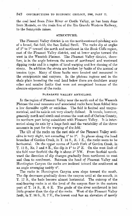
342 CONTKIBUTIONS TO ECONOMIC GEOLOGY, 1906, PAET II.
the coal land from Price River or Castle Valley, as has been done from Mounds, on the main line of the Eio Grande Western Railway, to the Sunnyside mines.
STRUCTURE.
The Pleasant Valley district is on the northwestward-pitching axis of a broad, flat fold, the San Rafael Swell. The rocks dip at angles of 5° to 7° toward the north and northeast in the Book Cliffs region, east of the Pleasant Valley district, and at lower angles toward the west in the Wasatch Plateau. The Pleasant Valley district, there fore, is in the angle between the areas of northward and Westward dipping rocks and is a region of local warping and low doming of the strata. In addition the strata are broken by faults of the normal or tension type. Many of these faults were located and measured in the escarpments and canyons. In the plateau regions and in the shale plain bounding the coal land below there are doubtless many other and smaller faults that were not recognized because of the obscure exposures of the rocks.
PLEASANT VALLEY ANTICLINE.
In the region of Pleasant Valley near the north end of the Wasatch Plateau the coal measures and associated rocks have been folded into a low domelike uplift or anticline. The fold is faulted and unsym- metrical, and its axis is not very clearly defined. It trends, however, generally north and south and crosses the west end of Carbon County, its northern part being coincident with Pleasant Valley. It is inter sected along its axis by a large fault aad the variability of the throw accounts in part for the warping of the fold.
The tilt of the rocks on the east side of the Pleasant Valley anti cline is very slight, not exceeding 1° to 2°. In places along the head branches of Gordon Creek, in T. 14 S., R. 7 E., the rocks seem to be horizontal. On the upper course of North Fork of Gordon Creek, in T. 13 S., Rs. 7 and 8 E., the dip is 1° to 2° E. On the west limb of the fold near Scofield the dip is about 3° NW. From Scofield sputh- ward the direction of dip changes gradually from northwest to west and then to southwest. Between the head of Pleasant Valley and Huntington Canyon the rocks are inclined toward the southwest at an angle averaging nea'rly 4°.
The rocks in Huntington Canyon area slope toward the south. The dip decreases gradually down the canyon until at the mouth, in T. 17 S., the beds become almost horizontal. The outcrop of the coal-bearing rocks is at the level of the canyon floor in the eastern part of T. 14 S., R. 6 E. The grade of the river southward is but little greater than the dip of the rocks. West of the Pleasant Valley fault, in T. 16 S., R. 7 E., the lowest coal has an elevation of nearly
PLEASANT VALLEY COAL DISTRICT, UTAH. $48
400 feet above .the river. Just east of the fault the same rocks have been dropped down to about 200 feet above the river. They rise steplike in a series of narrow fault blocks east of the Pleasant Valley fault, in the southeastern part of T. 16 S., K. 7 E.
The lowest coal bed is probably not less than 800 feet above the river at the mouth of the canyon and above Castle Valley between Huntington and Cottonwood canyons, at the south end of the area shown on the map.
FAULTS.
9The rocks of the Pleasant Valley district have been broken by
two groups of normal faults of considerable displacement. These faults trend in a general north-south direction. One group extends longitudinally through Pleasant Valley and southward across Hunt ington Canyon. It follows in a measure the axial trend of the PleasantValley anticline and may be described as the Pleasant Valley fault group. The other group of faults corresponds to the walls of Joes Valley, in the southwestern part of the district, and will be known as the Joes Valley faults.
PLEASANT VALLEY FAULTS.
The principal fault of the Pleasant Valley group is the western most one. It follows the west side of the valley in an almost due south course, crossing the foothills and spurs near the stream and passing through the west sides of Scofield and Clear Creek. North of Scofield it lies in a swampy valley and is not traceable. Whether there is a series of fractures or a. single fault is not determinable. The amount of throw or displacement is seen by the discordance jn elevation of the same rock beds in opposite sides of the valley. Cer tain accumulations of metamorphosed sandstone in different places in the valley north of Scofield suggest that there is more than one fault. The downthrow of the rocks due to this fault is toward the east and varies in amount from place to place. The greatest dis placement is near the center of the Pleasant Valley uplift.
Near the head of 'the valley opposite Clear Creek the throw is nearly 1,000 feet. The coal bed mined at the level of the canyon floor at Clear Creek outcrops near the top of the canyon wall 1,000 feet higher and 1 to 2 miles farther west. The outcrop of these beds descends northward to a point within a few hundred feet of the valley level west of Scofield, showing a decrease in throw of more than 500 feet in a distance of 6 miles. At the same rate of decrease the fault would almost disappear at the north end of the Pleasant Valley district.
From the head of Pleasant. Valley the fault veers slightly east of south, but it has not been located in the unsurveyed part of T. 14 S.,
344 CONTRIBUTIONS TO ECONOMIC GEOLOGY, 1906, PART II.
R. 7 E. The fault crosses Nuc Woodward Canyon in the north- central part of T. 15 S., R. 7 E., where it is distinctly traceable. The plane of fracture is almost vertical, but hades to the east, and the downthrow is in the same direction and amounts to 500 feet. The lowest coal bed, which outcrops high in the canyon wall on the west, is down at the base on the east side of .the fault. The same fault crosses Tie Fork Canyon at the northern boundary and Huntington Canyon near the center of T. 16 S., R. 7 E.
On Tie Fork the hade of the fault is almost vertical, and the down throw on the east is 350 to 400 feet. In Nuc Woodward and Tie canyons the fault bears about S. 5° E., but south of Tie Fork it curves westward, crossing Huntington Canyon with a bearing S. 5° W. The downthrow here and in North Fork of Meetinghouse Canyon is nearly 300 feet to the east. In South Fork of Meetinghouse Canyon, however, the throw is little more than 100 feet. Farther south, at some point in T. 17 S., E,. 7 E., the fault dies out. The accurate location of this fault in th'e high land between Pleasant Valley and Huntington Canyon is important, as it has a decided bearing on the question of minable coal lands.
The other faults of the Pleasant Valley group are shorter and the vertical displacements are less. At present they are known in two localities, Pleasant Valley and Huntington Canyon. In Pleasant Valley faults of small extent occur in the vicinity of the Clear Creek and Winterquarters mines. One is nearly half a mile east of Clear Creek and trends slightly west of south. The direction and amount of throw was not determined. The throw is certainly not very great, or else there are other faults on the east and near at hand with oppo site and compensating displacement. The outcrops of the coal at Clear Creek and on the headwaters of Gordon Creek to the east are at nearly the same level. Local faults are present south of Winter- quarters, but they trend in an east-west direction and the displace ments are less than 100 feet. Other faults of minor extent and throw probably occur in the vicinity of Pleasant Valley and at other places in the higher parts of the district and have escaped detection because of the soil cover and smooth surface features.
A number of faults cross Huntington Canyon within 2 miles east of the Pleasant Valley fault and nearly parallel to it. Their locations are indicated on the map (PI. XX, p. 338). They vary in throw from a few feet to nearly 250 feet, and in all of them the downthrow is toward the west. The total downthrow of these faults almost exactly compensates for the eastward downthrow of the Pleasant Valley fault. The minor faults almost surely do not extend more than 12 miles either northward or southward, for they are not visible in the escarpments along Gordon Creek on the north and Cottonwood Creek on the south. As usual, the planes of faulting are nearly vertical or slightly inclined toward the downthrow. The fault
PLEASANT VALLEY COAL DISTKICT, UTAH. 845
nearest the Pleasant Valley fault in Tie Canyon has a downthrow to the west of 100 to 150 feet; the other, near the east line of sec. 3, has a downthrow to the west of 200 to 250 feet. These two faults have a combined displacement approximately equal to all those showing in Huntington Canyon east of the Pleasant Valley fault. Where the faulting is less pronounced the rocks on either side are, as a rule, dis tinctly jointed in planes parallel to the fault line. It appears that the faults die out in a series of joints, some of which are miniature faults. Away from the faults and even near the larger ones the jointing of the rocks is not pronounced.
JOES VALLEY FAULTS.
Less is known of the faults in the Joes Valley region than of those in Pleasant Valley. They are farther back on the plateau, where rock exposures are less distinct and where minor faults are not easily detected.
A group of these faults, one of which has a pronounced displace ment, bears a few degrees west of south through the western part of the area represented by the map. The easternmost one has been precisely located in Huntington Canyon in sec. 14, T. 14 S., R. 6 E.; in West Fork of Huntington Canyon, sec. 11, T. 15 S.,.R. 6 E.; in Joes Valley, sec. 22, T. 16 S., R. 6 E.; and in sec. 32, T. 17 S., R. 6 E. Between these localities the fault was located approximately by reconnaissance. South of Huntington Canyon the fault is distinctly marked by a well-defined scarp several hundred feet high, which faces toward the'west. This fault scarp is especially prominent along the east side of Joes Valley, across Tps. 16 and 17 S., R. 6. E., and farther south. The downthrow of the fault is toward the west and amounts to probably not less than 1,000 feet.
The west side of Joes Valley near the border of the area mapped is bounded by a bluff closely resembling the fault scarp on the east side. The horizontal rocks exposed here also appear to be the same as the Mesaverde beds that occur on the east side of the Joes Valley fault. If this interpretation is correct there is a fault on the west side of the valley, the downthrow of which is toward the east and amounts to nearly the same as the displacement of the fault on the east side. At the southern boundary of T. 17 S., R. 6 E., the stream draining Joes Valley turns abruptly eastward and enters the deep and narrow gorge called Straight Canyon. Notwithstanding this change of the stream course, the broad flat valley with the fault scarps on either side continues toward the south, in line with Joes Valley, across the divide to Ferron Canyon, where both faults are distinctly shown. The downthrown fault block is here 2 miles in width. The throw of the eastern fault is 300 feet; that of the western is probably three times as great.
346 CONTRIBUTIONS TO ECONOMIC GEOLOGY, 1906, PART II.
Ferron Canyon is a deep gorge and the coal is exposed in its walls west of the fault block. It is probable also that the coal. is available by shaft in Straight Canyon west of the fault and near the southwest corner of T. 17 S., R. 6 E. In general the coal within and west of the fault block is probably not available except in the deeper valleys.
FAULTS EAST OF PLEASANT VALLEY.
Near the headwaters of North Fork of Gordon Creek, in the Book Cliffs escarpment, there are a number of small faults which vary in trend from nearly north and south to northwest and southeast. Two of these faults that bear a few degrees east of north are located near the head of Spring Canyon, in sec. 10, T. 13 S., R. 8 E. The downthrow of each is toward the other, and the displacement of the easterly fault is 150 to 200 feet. The throw of the other is not so easily determinable, but it seems to be somewhat less. These faults are .traceable northward into the SE. \ sec. 3. Two faults, corre sponding in strike and in direction of throw to those just described, were noted at the crest of the ridge in the N. ^ sec. 15. Thence they bear a few degrees east of south. The block between the faults is thrown down about 100 feet.
A fault bearing nearly due north and having a throw of 150 feet toward the west crosses the outcrop of the coal-bearing rocks in the E. | sec. 16. Another was noted in the NE. \ sec. 16 and the SW. I sec. 9. This bears N. 12° W., and the throw is small toward the east.
Two faults were located in the gulch near the southeast corner of sec. 16. The one with more northerly bearing has a displacement of 50 feet in the NW. £ sec. 21. Farther north, near the west line of sec. 16, it changes to a monoclinal fold. The other fault bearsN. 65° W. and has a downthrow of 20 feet to the southwest. Another fault crosses the NE. | sec. 20, bearing N. 50° W. with a downthrow of 50 feet to the southwest. Another, with nearly the same bearing, crosses the canyon near the center of the NE. £ sec. 19, with a throw to the northeast of 75 feet. Another fault, bearing due north, crosses the same canyon near the west line of sec. 19. Its downthrow is 50 feet toward the west. Two other small faults were noted in the unsurveyed part of T. 13 S., R. 7 E., near the head of North Fork of Gordon Creek. The downthrow of each is toward -the other and ranges from 30 to 50 feet, resulting in a narrow down thrown block.
All these faults are of the normal type, and the planes of fracture are nearly vertical where exposures permit examination. The smaller faults can not be traced, except where erosion has exposed the edges of the rock beds.
PLEASANT VALLEY COAL DISTKICT, UTAH. 347
COAL.
Coal has been prospected and mined at three localities in the Pleasant Valley district. These are in or near Pleasant Valley, in or near the Price River canyon in the vicinity of Castlegate, and in or near Huntington Canyon, in the northwestern, northeastern, and southern parts of the district, respectively. They could be easily reached by lines of transportation, and in the near future railroads may be constructed to them.
PLEASANT VALLEY.
Prospecting for coal in Pleasant Valley has not been thorough or extensive, except in the vicinity of the Clear Creek, Winterquarters, and Scofield mines. The outcrop of the coal-bearing rocks extends not only from Clear Creek, near the head of Pleasant Valley, to Sco field, but through the borders of the valley down West Fork of Price River almost to the east border of T. 12 S., R. 7 E. Along the east side of the valley the coal outcrops near the level of the streams from the mines at Clear Creek northward to Scofield. Its presence is attested by a number of prospects along the outcrop and by the mines at Clear Creek and Scofield. The pitch of the coal toward the north is but little greater than the grade of the valley, and continues at approximately the same angle down the east side of the valley through T. 12 S., R. 7 E. The same coal-bearing beds outcrop at higher elevations on the west side of Pleasant Valley from its head, in T. 14 S., R. 7 E., to Fish Creek, in T. 12 S., R. 7 E. The difference in elevation of the coal on opposite sides of the valley is caused by the fault that trends with the valley, following the west side of the stream. Opposite Clear Creek the coals on the west side are nearly a thousand feet above the valley floor. The northward inclination of'the coal beds is greater, on the west than on the east side of the valley. In sees. 30 and 31, T. 12 S., R. 7 E., the lowest coal bed mined is scarcely 200 feet above the plain of Pleasant Valley. Near the northeast corner of sec. 19, T. 12 S., R. 7 E., the same beds descend to the valley floor and toward the north pass beneath the surface. The presence of coal on the west side of the valley is attested by many prospects and the Winterquarters mine, as well as by certain prominent and characteristic sandstone -beds that are associated with the beds of coal. These sandstone beds are not exposed con tinuously, but they can be seen here and there, and the coal beds lie in definite positions with respect to them. Coal-bearing rocks corresponding to those at Clear Creek occur also on the east side of the divide in slopes leading to Castle Valley, a few miles east of Clear Creek, and on the west in Huntington Canyon, in the northeastern part of T. 14 S., R. 6 E.
,348. CONTRIBUTIONS TO ECONOMIC GEOLOGY, 1906, PART II.
At least four coal beds of workable thickness and of commercial quality are known in Pleasant Valley, and they occur in succession one above another through about 600 feet of rocks. These coal beds may be separated into two groups. The first comprises two beds, in places three, that lie in the lower part of the coal-bearing section. These are the thickest and most accessible beds, and in consequence are the ones most extensively developed. They are mined at Clear Creek and Winterquarters and have been mined at Scofield. Coal beds in the same group have been prospected on the west side of the valley opposite Clear Creek, between Clear Creek and Scofield, and north of Winterquarters, in sees. 19, 30, and 31, T. 12 S., R. 7 E.
The coal that is mined at Clear Creek crops out at the base of the valley near the center of the W. J sec. 33, T. 13 S., R. 7 E. It has been mined eastward into the mountain a-distance of nearly one- half mile and in a north-south direction for more than 7,000 feet. The coal bed varies in thickness from north to south. In the south ern part of the mine it is 13 feet 5 inches thick. Near the center of the workings a thin shale parting enters the coal. Toward the north, within a distance of 2,000 feet, the shale swells to 16 feet, dividing the coal bed into two benches. Where the shale is thick, only the upper bench of 4 feet 6 inches of coal is worked.
A coal bed at the same geologic horizon as that mined at Clear Creek and another bed 100 feet higher have been.prospected in not less than fifteen localities in sec. 31, T. 13 S., R. 7 E. In most places the earth has fallen into the pits, partially concealing the coal. In the SW. \ NE. \ sec. 31 a prospect on the lower bed shows 11 feet of coal, the base and the top being concealed. In the SE. J NW. \ sec. 31, 6 to 8 feet of coal are exposed. Water in the pit prevented further examination of the bed. A prospect on the second bed 100 feet above the first, located in the SW. \ NW. \ sec. 31, exposes 15 feet of coal. The same bed has been exposed in the NE. \ SW. \ sec. 31, showing 17 feet of massive coal. In the south half of the same section two coal beds 25 feet apart have been prospected. A partial exposure of one shows 5 feet and of the other 10 feet of clean coal.
Near the center of the east side of T. 13 S., R. 6 E., the bed that is mined at Winterquarters and Clear Creek, or one near the same stratigraphic position, is mined, and the coal is hauled to Scofield. The bed has a clear, section of coal 12 feet thick. Mining was begun here on the north side of the canyon by a slope, but this was aban doned, and an entry has been driven on the rise of the bed toward the south.
One of the beds near the base of the coal-bearing section has been mined for a number of years at Winterquarters, and this mine is now
PLEASANT VALLEY COAL DISTRICT, UTAH. 349
in active operation. The workings are at present toward the south on the rise of the bed. The same bed has been worked northward into the N. $ sec. 31, T. 12 S., R. 7 E. The coal in the mine at present worked is 9 to 16 feet thick and has no partings.
A number of prospects have been made and an entry opened from the Scofield mine in a gulch in the N. £ sec. 31, T. 12 S., R. 7 E., but the coal bed is not now exposed. One prospect in the SE. £ NW. I sec. 31 shows 4 feet 9 inches of coal between beds of sandstone. In the NW. J SE. \ sec. 35 the coal is 5 feet 10 inches clear.
One of the lower workable beds was formerly mined at the south east side of Scofield by the Union Pacific Company, but the plant is abandoned and in charge of a keeper. The bed is reported to be about 30 feet thick, but the middle portion only was worked, because of the great thickness and for the reason that coal forms a better roof and floor than the country rocks. South of the main entry of the old working a cave-in has occurred in a small gulch, exposing two overlying workable beds. The upper of these beds is 9 feet thick, the lower is 5 feet 3 inches, and the two are separated by 5 feet of shale and thin sandstone beds. The proximity of these coal beds to the lower and thicker one that has been mined will depre ciate their value unless the higher beds are mined first, which is not likely to occur.
One, probably two, workable coal beds occur above the coal that has been mined at Clear Creek, Winterquarters, and Scofield. The first of these is nearly 200 feet above the Clear Creek bed, and it has been opened in two prospects one-fourth to one-half mile southeast of Clear Creek. The coal in the southern of these pros pects is exposed for 5 feet 3 inches in a shallow pit. The relations of the contact rocks are not clear on account of the deep covering of soil. The indications are that the coal is of fair quality.
Another coal bed, estimated to be 500 feet above the Winterquar ters bed, has been prospected at a number of places in sees. 10, 11, 13, and 14, T. 12 S., R. 7 E., near the railroad in Pleasant Valley Canyon. This bed, as shown in prospect pits in sees. 10, 11, and 13, ranges in thickness between 3 feet 6 inches and 3 feet 7 inches. The roof is usually shale and the floor sandstone. Locally the shale thins out and sandstone comes into contact with the coal. The bed has been mined in sec. 14, but the entry is now closed by fallen earth. The coal is clear and mines in 'small blocks, with the produc tion of considerable slack.
What appears to be the same bed is being mined by Mr. Metcalf on unsurveyod land in the northeastern part of T. 12 S., R. 6 E., near the location of sec. 2, in the canyon of North Fork of Fish Creek. The coal has the same thickness and similar contact rela tions as the bed in the prospects in Pleasant Valley Canyon. This
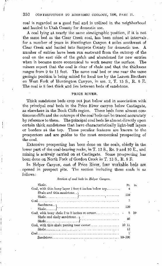
350 CONTRIBUTIONS TO ECONOMIC GEOLOGY, 1906, PART II.
coal is regarded as a good fuel and is utilized in the neighborhood and hauled to Utah County for domestic use.
A coal lying at nearly the same stratigraphic position, if it is not the same bed as the Clear Creek coal, has been mined at intervals for a number of years in Huntington Canyon 4 miles southwest of Clear Creek and hauled into Sanpete County for domestic use. A number of entries have been run eastward from the outcrop of the coal on the east side of the gulch and abandoned for new entries when it became more economical to work nearer the surface. The miners report that the coal is clear of shale and that the thickness ranges from 9 to 11 feet. The same coal bed or one near the same geologic position is being mined for local use by the Larsen Brothers on West Fork of Huntington Canyon, in sec. 2, T. 15 S., R. 6 E. The coal is 8 feet thick and lies between beds of sandstone.
PRICE RIVER.
Thick sandstone beds crop out just below and in association with the principal coal beds in the Price River canyon below Castlegate, as elsewhere in the Book Cliffs region. These beds form almost con tinuous cliffs and the outcrops of the coal beds can be traced accurately by reference to them. The principal coal beds lie almost directly upon certain thick sandstones that have characteristically light-buff layers or borders at the top. These peculiar features are known to the prospectors and are guides to the most economical prospecting of the coal.
Extensive prospecting has been done on the coals, chiefly in the lower part of the coal-bearing rocks, in T. 13 S., Rs. 9 and 10 E., and mining is actively carried on at Castlegate. Some prospecting has been done on North Fork of Gordon Creek in T. 13 S., R. 8 E.
In Helper Canyon, east of Price River, four workable beds are opened in prospect pits. The section including these coals is as follows:
Section of coal beds in Helper Canyon.
Shale. . Ft. in. Coal, with thin bony layer 1 foot 6 inches below top......... 4
Shale and thin sandstone..) Shale...................../'""""""""r"""" 1U
Coal...................................................... 7Sandstone.. ̂Shale.......}'"""""""""""""" """""
Coal, with bony shale 2 to 3 inches at center............... ; 5 10Shale and shaly sandstone..| .»Shale......................}""""'""""""""
Coal, with thin shale parting near center................... 10-11Shale................................................ 12
Coal...................................................... 1Sandstone........................................... 80-100
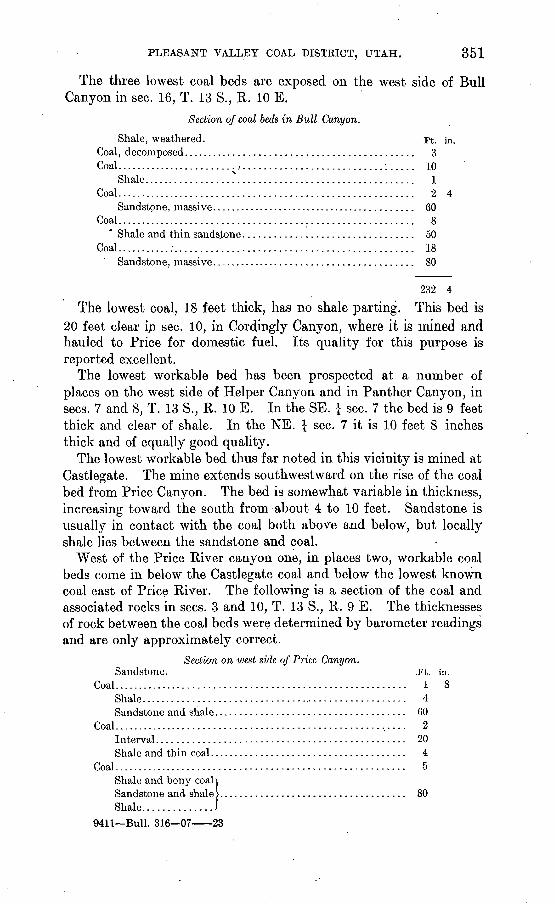
PLEASANT VALLEY COAL DISTRICT, UTAH. 351
The three lowest coal beds are exposed on the west side of Bull Canyon in sec. 16, T. 13 S., R. 10 E.
Section of coal beds in Bull Canyon.
Shale, weathered. Ft. in.Coal, decomposed............................................. 3Coal.. .....................^...........................:..... 10
Shale.................?.................................. 1Coal.......................................................... 2 4
Sandstone, massive.......................................... 60Coal. ......................................................... 8
Shale and thin sandstone................................. 50Coal...........:.............................................. 18
Sandstone, massive........................................ 80
232 4
The lowest coal, 18 feet thick, has no shale parting. This bed is 20 feet clear in sec. 10, in Cordingly Canyon, where it is mined and hauled to Price for domestic fuel. Its quality for this purpose is reported excellent.
The lowest workable bed has been prospected at a number of places on the west side of Helper Canyon and in Panther Canyon, in sees. 7 and 8, T. 13 S., R. 10 E. In the SE. \ sec. 7 the bed is 9 feet thick and clear of shale. In the NE. \ sec. 7 it is 10 feet 8 inches thick and of equally good quality.
The lowest workable bed thus far noted in this vicinity is mined at Castlegate. The mine extends southwestward on the rise of the coal bed from Price Canyon. The bed is somewhat variable in thickness, increasing toward the south from about 4 to 10 feet. Sandstone is usually in contact with the coal both above and below, but locally shale lies between the sandstone and coal.
West of the Price River canyon one, in places two, workable coal beds come in below the Castlegate coal and below the lowest known coal east of Price River. The following is a section of the coal and associated rocks in sees. 3 and 10, T. 13 S., R. 9 E. The thicknesses of rock between the coal beds were determined by barometer readings and are only approximately correct.
Section on west side of Price Canyon.Sandstone. .Ft. in.
Coal......................................................... 1 8Shale.................................................... 4Sandstone and shale..................................... 60
Coal......................................................... 2Interval................................................ 20Shale and thin coal...................................... 4
Coal......................................................... 5Shale and bony coaljSandstone and shale >.................................... 80Shale..............J
9411 Bull. 316 07 23
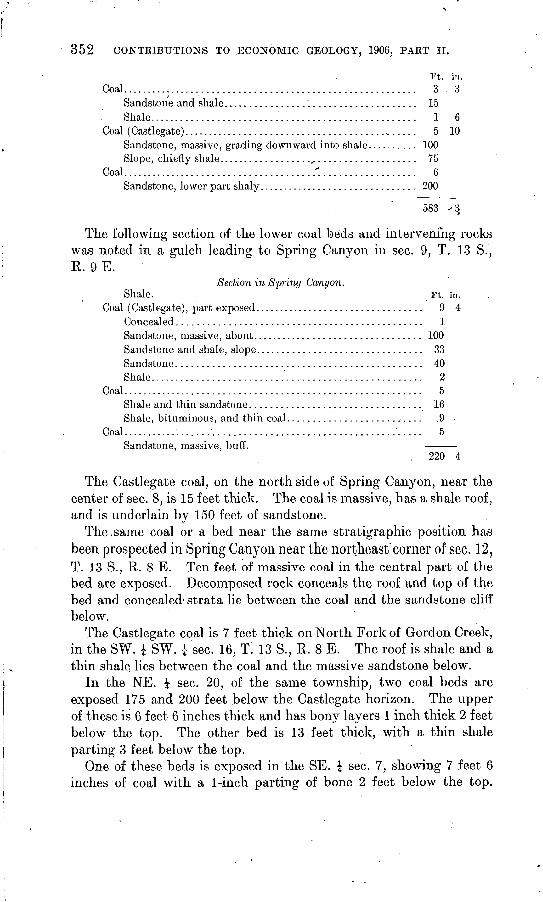
352 CONTRIBUTIONS TO ECONOMIC GEOLOGY, 1906, PAET II.
Ft. in.Coal......................................................... 3 . 3
Sandstone and shale. .................................... 15Shale................................................... 1 6
Coal (Castlegate)............................................. 5 10Sandstone, massive, grading downward into shale.......... 100Slope, chiefly shale....................................... 75
Coal......................................'.................. 6Sandstone, lower part shaly............................... 200
583 ^3
The following section of the lower coal beds and intervening rocks was noted in a gulch leading to Spring Canyon in sec. 9, T. 13 S., R. 9 E.
Section in Spring Canyon.Shale. . Ft. in.
Coal (Castlegate), part exposed................................. 9 4Concealed............................................... 1Sandstone, massive, about................................. 100Sandstone and shale, slope................................ 33Sandstone............................................... 40Shale.................................................... 2
Coal.......................................................... 5Shale and thin sandstone................................. 16Shale, bituminous, and thin coal.......................... .9
Coal.......................................................... 5Sandstone, massive, buff.
. 220 4
The Castlegate coal, on the north side of Spring Canyon, near the center of sec. 8, is 15 feet thick. The coal is massive, has a shale roof, and is underlain by 150 feet of sandstone.
The.same coal or a bed near the same stratigraphic position has been prospected in Spring Canyon near the northeast'comer of sec. 12, T. 13 S., R. 8 E. Ten feet of massive coal in the central part of the bed are exposed. Decomposed rock conceals the roof and top of the bed and concealed strata lie between the coal and the sandstone cliff below.
The Castlegate coal is 7 feet thick on North Fork of Gordon Creek, in the SW. J SW. J sec. 16, T. 13-S., R. 8 E. The roof is shale and a thin shale lies between the coal and the massive sandstone below.
In the NE. \ sec. 20, of the same township, two coal beds are exposed 175 and 200 feet below the Castlegate horizon. The upper of these is 6 feet 6 inches thick and has bony layers 1 inch thick 2 feet below the top. The other bed is 13 feet thick, with a thin shale parting 3 feet below the top.
One of these beds is exposed in the SE. \ sec. 7, showing 7 feet 6 inches of coal with a 1-inch parting of bone 2 feet below the top.

PLEASANT VALLEY COAL DISTRICT, UTAH. 353
The same bed in the NE. | sec. 19 is 7 feet thick and has the same bony streak 2 feet below the top.
The coal-bearing rocks near the headwaters of Gordon Creek, in Tps. 13, 14, and 15 S., R. 7 E., and T. 15 S., R. 8 E., are not well exposed, and little or no prospecting has been done. A coal bed at or near the horizon of the Castlegate coal is exposed on a spur at the head of Bob Wright Canyon in tmsectioned land, 6 to 7 feet of weath ered coal being visible. The same bed shows 6 to 8 feet of coal in the location of the unsurveyed NW. \ SW. \ sec. 14, T. 14 S., R. 7 E. As usual, it occurs just above the massive sandstone and appears to have a shale roof.
HUNTINGTON CANYON.
From the northern part of T. 15 S., R. 8 E., southward through and beyond Huntington Canyon the coal-bearing rocks crop out in barren cliffs, as in the Book Cliffs region. In Miller, Cedar, and Huntington canyons the coals are naturally exposed in many places, and considerable prospecting and some mining has.been done. The coal beds occur in the same group of rocks as the coal beds in the vicinity of Castlegate. Whether or not any bed is continuous from one area to the other can not be determined until mining or drilling is done in the intermediate region. The two lower beds, however, overlie the same sandstone formation as the two lower beds on the west side of Price Canyon, and a higher bed occurs in the same rel ative position as the Castlegate coal.
Natural outcrops of the lower beds occur in many places in sees. 21 and 22, T. 15 S., R. 8 E. The full thickness of the beds is rarely exposed in these natural outcrops. The lowest bed in the SW. \ NE. } sec. 21 shows 11 feet of clear coal. In the southeast quarter of this section the exposure shows 9 feet of coal. The bed is over lain by sandstone, and light-blue clay a few feet thick usually occurs between the coal and the sandstone cliff below. The same bed has an exposure of 10 feet in an old prospect in the SW. J NW. \ SE. £ sec. 17, T. 15 S., R. 8 E.
An old prospect on a bed at the Castlegate horizon a short dis tance north of the center of the E. £ sec. 19 shows 6£ feet of coal, the bed being partially concealed.
The lowest coal bed shows in prospects on Middle Fork of Miller Creek, in the NW. \ SE. \ NW. \ sec. 29. A partial exposure of the bed gives 9 feet of clear coal. The Castlegate bed is prospected in the NE. \ SE. \ NE. J sec. 30, showing 6 feet of coal, with a thin parting of bone 6 inches below the top.
The two lower beds have been mined for local use in the NE. \ NW. \ sec. 32, T. 15 S., R. 8 E., the upper one being -5 feet and the lower 10 feet 6 inches thick; both are clear coal. The lower coal
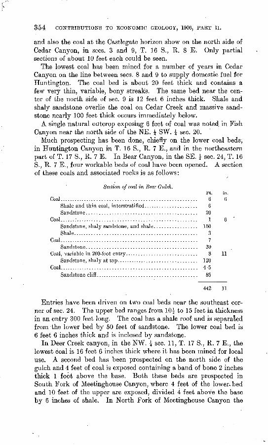
354 CONTRIBUTIONS TO ECONOMIC GEOLOGY, 1906, PART II.
and also the coal at the Castlegate horizon show on the north side of Cedar Canyon, in sees. 3 and 9, T. 16 S., R. 8 E. Only partial sections of about 10 feet each could be seen.
The lowest coal has been mined for a number of years in Cedar Canyon on the line between sees. 8 and 9 to supply domestic fuel for Huntington. The coal bed is about 20 feet thick and contains a few very thin, variable, bony streaks. The same bed near the cen ter of the north side of sec. 9 is 12 feet 6 inches thick. Shale and shaly sandstone overlie the coal on Cedar Creek and massive sand stone nearly 100 feet thick occurs immediately below.
A single natural outcrop exposing 6 feet of coal was noted, in Fish Canyon near the north side of the NE. J SW. \ sec. 20.
Much prospecting has been done, chiefly on the lower coal beds, in Huntington Canyon in T. 16 S., K. 7 E., and in the northeastern part of T. 17 S., R. 7 E. In Bear Canyon, in the SE. J sec. 24, T. 16 S., R. 7 E., four workable beds of coal have been opened. A section of these coals and associated rocks is as follows:
/
Section of coal in Bear Gulch.Ft. in.
Coal...................................................... 6 6Shale and thin eoal, interstratified..................... 6Sandstone........................................... 20
Coal......:............................................... 1 6 'Sandstone, shaly sandstone, and shale................. 150Shale................................................ 3
Coal...................................................... 7Sandstone........................................... 30
Coal, variable in 200-foot entry............................ 8 11Sandstone, shaly at top................................ 120
Coal...................................................... 4-5Sandstone cliff.. ...................................... 85
442 11
Entries have been driven on two coal beds near the southeast cor ner of sec. 24. The upper bed ranges from 10^ to 15 feet in thickness in an entry 300 feet long. The coal has a shale roof and is separated from the lower bed by 50 feet of sandstone. The lower coal bed is 6 feet 6 inches thick and is inclosed by sandstone.
In Deer Creek canyon, in the NW. £ sec. 11, T. 17 S., R. 7 E., the lowest coal is 16 feet 6 inches thick where it has been mined for local use. A second bed has been prospected on the north side of the gulch and 4 feet of coal is exposed containing a band of bone 2 inches thick 1 foot above the base. Both these beds are prospected in South Fork of Meetinghouse Canyon, where 4 feet of the lower, bed and 10 feet of the upper are exposed, divided 4 feet above the base by 6 inches of shale. In North Fork of Meetinghouse Canyon the
PLEASANT VALLEY COAL DISTRICT, UTAH. 355
upper bed is 11 feet thick and the 6-inch shale parting is 3$ feet above the base. The lower bed has the following section:
Section of lower coal in North Fork of Meetinghouse Canyon.
Sandstone, massive. Ft. in.Shale..................................................... 2
Coal......................................................... 1Shale and sandstone ...................................... 6
Coal......................................................... 1 6 *Shale........................................................ 6Coal......................................................... 13 6
Sandstone, massive cliff. 24 6
Three coal beds are exposed in Ridley Canyon near the northeast corner of sec. 28, T. 17 S., R. 7 E. The following is the section:
Section of coal beds in Ridley Canyon.Sandstone. . Feet.
Coal, in part burned, exposed .................................... 8Sandstone... t.............................................. 30
Coal ......... .....................................:........... 2Sandstone and shale......................................... 30
Coal.............................................:............. 10Sandstone.................................................. 75
155
Two beds are opened near the mouth of Trail Gulch. The.lower is exposed between cliffs of sandstone in the NW. £ SW. \ sec. 23, T. 16 S., R. 7 E., where it is 7 feet 10 inches thick, and in the NE. i NE. \ sec. 22, where it consists of 6 feet of clear coal. The upper bed, 60 feet higher in the section, is opened by an entry 200 feet long near the center of the east side of sec. 22. Water in the entry prevented exploration, but at the opening the bed shows 14 feet of coal from the base upward. The roof is concealed and decomposed rock covers the top of the bed. The prospector who dro(ve the entry reports that at 100 feet from the outcrop the bed is 16 feet 4 inches thick.
The same two coals have been prospected extensively in Mill Gulch and on the west side of Huntington Canyon, in sees. 16 and 17, T. 16 S., R. 7 E. The lower bed ranges, in thickness from 4 to 6 feet. An intermediate bed 3 feet 3 inches thick was located in the SE. | sec. 16. Less attention has been given to prospecting the upper bed in this locality and but one full section of the coal was noted. Near the center of the east side of sec. 17 the bed is partially burned near the surface, but 3 feet in the lower part could be seen. In the SE. J SW. J sec. 16 this coal is 14 feet thick and lies between beds of sand stone.
356 CONTRIBUTIONS TO ECONOMIC GEOLOGY, 1006, PART II.
The same beds are opened in Little Bear Canyon, in the NW. £ sec. 9. The upper bed is broken by shale partings, as shown in the following section:
Section in Little Bear Canyon, in'the NW. | sec. 9,- T. 16 S., R. 7 E.
Ft. in. Shale, bony............................................. 3Sandstone, shaly......................................... 4
'Coal ........................................................ 2. 3Shale, sandy............................................. 2 10
Coal, and shale in thin bands ................................. 1 6Coal, lower bench of upper bed............................... 6
Sandstone and shale slope, with thin band of intermediate coal................................................... 50
Coal, lower bed ............................................... 5Sandstone, massive, in cliffs.
74 7
A similar section is exposed in Tie Canyon, in the NW. J sec. 3, T. 16 S., R. 7 E., as follows:
Section in Tie Canyon.
Slope, rocks concealed. Ft. in.Shale, bone, and thin coal layers ......................... 3
Coal ........................................................ 1 10Shale.................................................... 8
Coal, lower bench of upper bed ............................... 3 10Sandstone and shale beds ................................. 60
Coal, lower bed.. ............................................. 7 5Sandstone, in cliffs. -
76 9
The lowest bed is exposed in Crandalls Canyon, in the NW. £ sec. 5, T. 16 S., R. 7 E., with a thickness of 5 feet 6 inches.
Little prospecting has been done in Huntington Canyon in Tps. 14 and 15 S., R. 7 E. Apparently the lowest coal commonly found in this canyon in Tps. 16 and 17 S., R. 7 E., thins out farther north.
The lowest workable coal bed has been mined intermittently for a number of years at the Johnson mine, in Cottonwood Canyon, near the center of sec. 25, T. 17 S., R. 6 E. The thickness ranges from 7 feet 6 inches to 8 feet and the bed has no parting. It is overlain by shaly sandstone and has a massive sandstone floor.
The same coal bed has been worked for local use at the Reed mine, near the south side of sec. 22, and at the Otterson mine, near the east side of sec. 26, T. 17 S., R. 7 E. At the Reed mine the coal is 7 feet 6 inches thick and clear of shale. It has a variable but thin bony shale roof and lies upon sandstone. The coal at the Otterson mine is 11 feet "10 inches thick, but contains a variable thin shale parting near the middle. Shale and thin coal in alternate

PLEASANT VALLEY COAL DISTRICT, UTAH. 357
layers with a total thickness of 3 feet 8 inches overlie the Otterson coal and a thin bony shale lies between it and the thick sandstone formation below.
QUALITY OF COAL.
In 1905 samples for analytical tests were collected from the prin cipal coal beds in this district and in the Book Cliffs farther east. Proximate analyses of these samples were published in a brief report on the Book Cliffs coal field. 0 Similar samples were collected in the Pleasant Valley district during the last summer. These samples were obtained by cutting a channel across the face of the coal beds, all the partings more than three-eighths of an inch thick being rejected. The material thus obtained was crushed and quartered until a quart sample was obtained of coal that would pass through a half-inch mesh. This was sealed air-tight in a galvanized-iron can and sent to the chemical laboratory. The "analyses were made at the fuel-testing plant of the United States Geological Survey at St. Louis, Mo., by F. M. Stanton, chief chemist. They are as follows:
Proximate analyses of coal samples from the Pleasant Valley district, Utah.
Analysis of sample as received:
Ash............................
Loss of moisture on air drying. .. . .
Analysis of air-dried sample:
Ash............................
Castlegate.
2098.
472 39.13 48.45 7.70 .49
1.30
3.47 39. 64 49.09 7.80 .50
2097.
6.13 40.07 45.45 8.35 .56
3.50
2.73 41.52 47,10 8.65 .58
AVinter- quarters.
2541.
8.10 40.21 45..91 5.78 .86
' 3. 90
4.37 41.84 47.77 6.02 .89
Clear Creek.
542.
7.02 41.89 45.80 5.29 .57
3.10
404 43.23 47.27 5.46 .58
Sec. 11, T. 14 S., R. 6E.
2409.
5.19 43.89 46.91 4.01 -.31
2.30
2.90 44^92
. 48. 02 410 .32
Sec. 24, T. 16 S., R. 7 E.
2410.
6.04 38. 96 48.40 6.60 .83
2.90
3.23 40.12 49.85 0.80 .85
Sec. 2, T.15S., R. 6E.
2387.
8.46 41. 17 40.09 428 .48
3.50
5. 15 42.75 47.86 4.44 .50
These analyses are representative of several coal beds. They show an- evenly good grade of fuel, moderately low in moisture and ash, and remarkably low in sulphur. The low percentage of sulphur seems to be characteristic of the Cretaceous coals in the Rocky Mountain region.
Coking tests have not been made of all the workable coals in this district. The beds now mined, however, have not produced mer chantable coke.
The coals of the Pleasant Valley district generally contain little hygroscopic water. The coal in the thicker beds is generally massive and mines in somewhat uneven and often large blocks. Most of
a Contributions to Economic Geology, 1905: Bull. U. S. Geol. Survey No. 285,1900, p. 294.
358 CONTRIBUTIONS TO ECONOMIC GEOLOGY, 1906, PART II.
the coal has a bright luster and withstands long surface exposure without slacking. On their chemical and physical properties these coals should be classed as high-grade bituminous coal. They are regarded as an excellent domestic and steaming fuel.
DEVELOPMENT AND TRANSPORTATION.
Except for local domestic use the development of the Pleasant Valley district is limited to the Castlegate, Winterquarters, and Clear Creek mines. These mines produce annually about half a million tons, more than half the coal product of the State. A thick bed was once mined at Scofield by the Union Pacific Railroad Com pany, but was abandoned, it is reported, because of transportation difficulties.
The transportation of coal in this region is entirely in the control of the Rio Grande Western Railway. Castlegate is on the main line of this road and the Pleasant Valley mines are reached by a branch from Colton, near the summit of the Wasatch Plateau. The outcrops of the coal beds may be reached by roads from Castle Valley up any of the larger valleys and canyons. The coal in Hunt- ington Canyon has a long and tortuous outcrop. The canyon is deep and has a narrow but flat floor. The grade is believed to be less than that of Price River above Castlegate. Similar conditions are to be found in Cott.onwood Cay on, at the south edge of the district.
THE IRON COUNTY COAL FIELD, UTAH,
By WILLIS T. LEE.
INTRODUCTION.
This paper is a brief preliminary report on the occurrence and character of the coal of Iron County, southwestern Utah. During the summer of 1906 the principal c.oal openings were visited, the coal was sampled for analysis, and the stratigraphic position of the coal- bearing sediments was determined. No attempt, however, was made at mapping the outcrops.
The occurrence of workable coal in southwestern Utah has been known since the year 1854, when the first mine of this region was opened. The coal is located in Colob Plateau, east of Cedar City and Kanarraville, and to the west of the plateau in the eastern slope of Pine Valley Mountain near New Harmony. (See PI. XXI.) The coal has long been of local importance, but it is so far from any large market that it has not been of great value until the construction of the San Pedro, Los Angeles and Salt Lake Railroad, which now passes within 35 miles of the principal outcrops. A branch might easily be constructed from this road to some of the most promising mines.
Little is known of the quality, the available quantity, and the accessibility of the coal. The structure of the region is such that some of the coal outcrops in the precipitous cliffs bordering the plateau, 3,000 feet or more above the plains to the west, and some of it outcrops at the bottoms of canyons and near the level of the plains. For these reasons a knowledge of the geography, the stratig raphy, and the structure of the region is necessary in order to form a proper estimate of the value of the coal lands. ,
SURFACE FEATURES.
The coal of Iron County outcrops mainly in the cliffs at the western margin of Colob Plateau, which has an elevation of about 9,500 feet, about 4,000 feet greater than that of the Great Basin to the west. The streams have eroded a few sharp canyons near the edge of the
359
860 CONTRIBUTIONS TO ECONOMIC GEOLOGY, 1906, PART II.
plateau, the largest of which is that of Coal Creek. Although this creek, as it emerges from its canyon, is a stream of considerable size, its waters are soon absorbed by the sands and gravels of the Lake Bonneville beds of the Escalante Desert.
The ruggedness of the country in the vicinity of the coal deposits is perhaps the most serious drawback to their development. A railroad might easily be built to the foot of the Colob escarpment, but most of the coal lies near the top of the plateau, 3,000 feet or more above the base. Railroad lines are said to have been surveyed, connecting the Coal Creek and New Harmony mines with the San Pedro, Los Angeles and Salt Lake Railroad to the west, but no construction work has been done on them.
GEOLOGY.
DETAILED SECTIONS.
COLOB PLATEAU.
At the coal mine 4 miles east of Kanarraville a section was measured from the coal bed to the top of the plateau. A considerable thickness of the coal-bearing formation has been eroded at this place and the plateau is covered with basalt. The part remaining, having a thick ness of 463 feet, is, therefore, only the base of the formation. In the canyon of Coal Creek the remaining part was found to be 1,100 feet thick. No detailed section .was obtained above the coal in this canyon, but the upper beds, so far as observed, are not notably differ ent in composition and physical character from the lower ones, and the same species of fossils were found through the entire thickness.
The Coal Creek canyon affords exceptionally good opportunities for making detailed geologic sections. The older formations are steeply upturned near the mouth of the canyon, and the younger formations lie more nearly horizontal a few miles farther upstream. The thick nesses given in the accompanying section were obtained by barometer where the strata are horizontal and by pacing across the strike and correcting for dip where the rocks are upturned. The coal bed (Lunt mine) at the top of this part of the section (No. 9) is presumably the same as that of the Kanarraville coal and is the means by which the upper and middle parts of the section are connected.
The basal beds of the red shale and sandstone are not exposed on Coal Creek, but the lower members, together with an underlying massive limestone, are exposed near Kanarraville. About 5 miles south of this, town a section was measured extending from the lime stone (No. 33 of the section), which is imperfectly exposed along Coal Creek to the base of the plateau. Fossils were collected from this limestone, both in the Coal Creek canyon and south of Kanar raville, and the forms were determined by G. H. Girty to be the
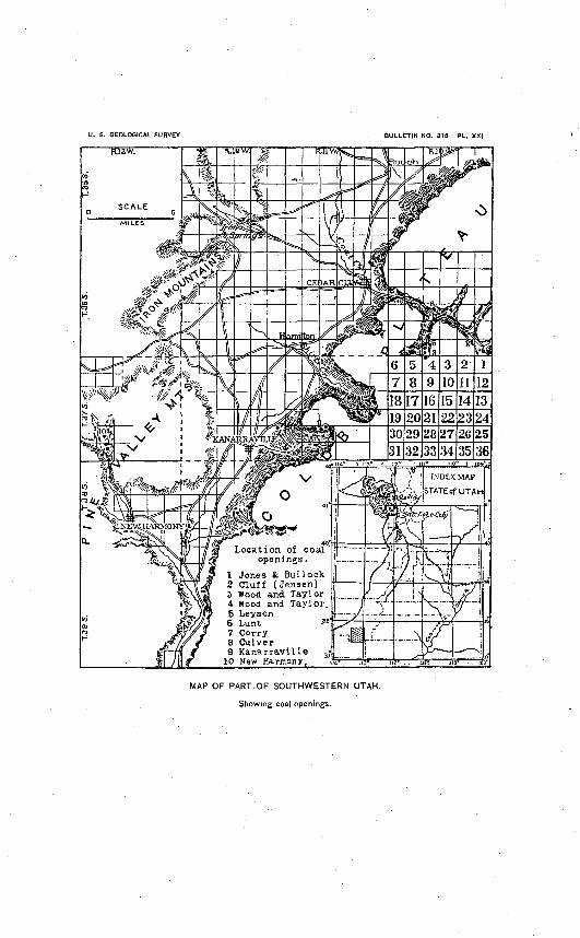
U. S. GEOLOGICAL SURVEY BULLETIN NO. 318 PL. XXI
INDEX MAP
STATE of UTAH
Location of coal openings.
1 Jones & BullocK2 Cluff .(Jensen) 5 Wood and Taylor4 Wood and Taylor.5 Leyson6 Lunt -3e7 Corry8 Culver9 Kanarraville
10 New Harmony.
MAP OF PART OF SOUTHWESTERN UTAH.
Showing coal openings.
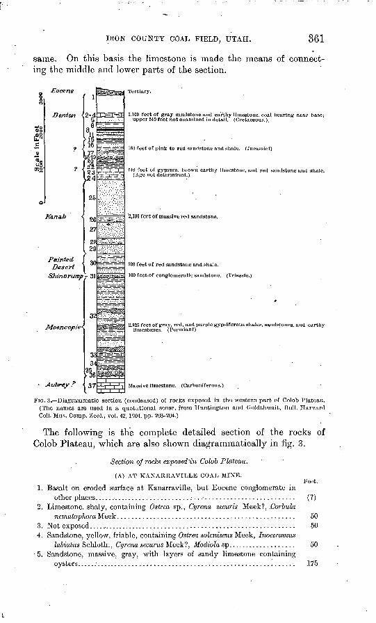
IRON COUNTY COAL FIELD, UTAH. 361
same. On this basis the limestone is made the means of connect ing the middle and lower parts of the section.
s§TOO
Eocene
J3er>1an 2-4EESF3:
23 L24
25
Painted IDesert | "~
Shinarump- 31
Moencopie-
Aubrey ?
32
37
Tertiary.
1,100 feet of gray sandstone and earthy limestone, coal hearing near hase; upper 510 feet not examined in detail. (Cretaceous.).
780 feet of pink to red sandstone and shale. (Jurassic!)
040 feet of gypsum, hrowu earthy limestone, and red sandstone and shale. (Age not determined.)
'2,130 feet of massive red sandstone.
520 feet of red sandstone and shale.
100 feet of conglomeratic sandstone. (Triassic.)
2.825 feet of gray, red. and purple gypsiferous shales, sandstones, and earthy limestones. (Permian?)
Massive limestone. (Carboniferous.)
FIG. 3- -Diagrammatic section (condensed) of rocks exposed in the western part of Colob Plateau. (The names are used in a quotational sense, from Huntington and Goldthwait, Bull. Harvard Coll. Mus. Corap. Zoo!., vol. 42, 1004, pp. 203-204.)
The following is the complete detailed section of the rocks of Colob Plateau, which are also shown diagrammatically in fig. 3.
Section of rocks exposed'in Colob Plateau.
(A) AT KANARRAVILLE COAL MINE.Feet.
1. Basalt on eroded surface at Kanarraville, but Eocene conglomerate inother places. ......................................................... (?)
2. Limestone, slialy, containing Ostrea sp., Cyrena securis Meek?, .Corbulanematophora Meek....... I......................................... 50
3. Not exposed........................................................... 504. Sandstone, yellow, friable, containing Ostrea soleniscus Meek, Inoceramus
labiatus Schloth., Cyrena securus Meek?, Modiola sp................... 50 5. Sandstone, massive, gray, with layers of sandy limestone containing
oysters............................................................. 175
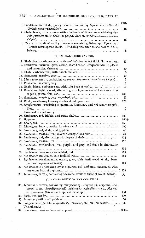
362 CONTRIBUTIONS TO ECONOMIC GEOLOGY, 1906,, PAET II.
Feet.6. Sandstone and shale, partly covered, containing Cyrena securis Meek?,
Corbula nematophora Meek........................................... 1157. Shale, black, carbonaceous, with thin bands of limestone containing Avi-
cula gastrodes Meek, Cardium pauperculum Meek, Glauconia coalvillensis (Meek)............................................................. 15
8. Coal with bands of earthy limestone containing Ostrea sp., Cyrena sp., Corbula nematophora Meek. (Probably the same as the coal of No. 9, below)............................................................ 8
(B) IN COAL CREEK CANYON.
9. Shale, black, carbonaceous, with coal bed about 4 feet thick (Lunt mine). 5510. Sandstone, massive, gray, coarse, cross-bedded, conglomeratic in places
and containing Ostrea sp...........:....... 7........................ v 3011. Shale, carbonaceous, with 6-inch coal bed. ............................. 512. Sandstone, massive, gray.............................................. 1013. Limestone, sandy, containing Ostrea sp., Glauconia coalvillensis (Meek).. 214. Sandstone, massive, gray.............................................. 1515. Shale, black, carbonaceous, with thin beds of coal.......... °............ 1016. Sandstone, light colored, alternating with layers of shale of various shades
of pink, green, blue, etc.............................................. 50017. Sandstone, massive, gray, cross-bedded................................. 5018. Shale, weathering to many shades of red, green, etc.................... 22519. Conglomerate, consisting of quartzite, limestone, and red-sandstone peb
bles.................................................................. 5Erosional unconformity.
20. Sandstone, red, friable, and sandy shale................................ 10021. Gypsum............................................................ 100+22. Shale,'red........................................................... 15023. Limestone, brown, earthy, forming a cliff............................... 25024. Sandstone, red, shale, and gypsum.................................... 4025. Sandstone, massive, red; makes a conspicuous cliff...................... 1, 05026. Sandstone, red, alternating with layers of shale......................... 17527. Sandstone, massive, red............................................... 47528. Sandstone, thin bedded, red, purple, and gray, and shale in alternating
layers............................................................. 18029. Sandstone, massive, cross-bedded, red.................................. 25030. Sandstones and shales, thin bedded, red................................ 52031. Sandstone, conglomeratic, coarse, gray, with fossil wood at the base.
(Araucarioxylon .arizonicum) ......................................... 10032. Sandstones in alternating layers of purple, red, and gray, and shales, with
numerous beds of gypsum........................................... 2,15033. Limestone, earthy, containing the same fossils as those of No. 33 below.. (?)
(C) 5 MILES SOUTH OF KANARRAVILLE.
34. Limestone, earthy, containing Composite sp., Pugnax aff. osagensis, Die- lasma (?) sp., Aviculipecten aff. occidentalis, Aviculipecten sp., Myalina aff. permiana, fiakewellia n. sp., Schizodus sp......................... 100
35. Shale, red, sandy...................................................... 40036. Limestone with small pebbles......................................... 5037. Conglomerate, pebbles of quartzite, limestone, etc., in lime matrix........ 125
Unconformity.38. Limestone, massive, base not exposed.................................... 300-f-
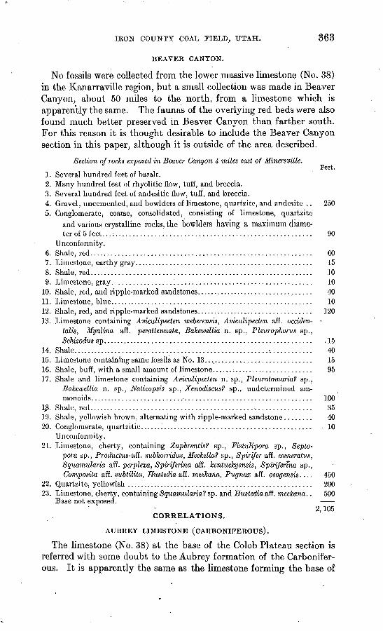
IKON COUNTY COAL FIELD, UTAH. 363
BEAVER CANYON.
No fossils were collected from the lower massive limestone (No. 38) in the Kanarraville region, but a small collection was made in Beaver Canyon, about 50 miles to the north, from a limestone which is apparently the same. The faunas of the overlying red beds were also found much better preserved in Beaver Canyon than farther south. For this reason it is thought desirable to include the Beaver Canyon section in this paper, although it is outside of the area described.
Section of rocks exposed in Beaver Canyon 4 miles east of Minersville.Feet.
1. Several hundred feet of basalt.2. Many hundred feet of rhyolitic flow, tuff, and breccia.3. Several hundred feet of andesitic flow, tuff, and breccia.4. Gravel, uncemented, and bowlders of limestone, quartzite, and andesite .. 2505. Conglomerate, coarse, consolidated, consisting of limestone, quartzite
and various crystalline rocks, the bowlders having a maximum diame ter of 5 feet...:...................................................... 90
Unconformity.6. Shale, red............................................................. 607. Limestone, earthy gray................................................. 158. Shale, red............................................................. 109. Limestone, gray....................................................... 10
10. Shale, red, and ripple-marked sandstones................................. 4011. Limestone, blue........................................................ 1012. Shale, red, and ripple-marked sandstones.................................. 12013. Limestone containing Amculipecten weberensis, Aviculipecten aff. occiden-
talis, Myalina aff. perattenuata, Bakewellia n. sp., Pleurophoms sp., Schizodus sp.......................................................... .15
14. Shale ......................................................^ ........... 4015. Limestone containing same fossils as No. 13............................... 1516. Shale, buff, with a small amount of limestone......:...................... 9517. Shale and limestone containing Aviculipecten n. sp., Pleurotomaria? sp.,
Bakewellia n. sp., Naticopsis sp., Xenodiscus? sp., undetermined am- monoids.............................................................. 100
]£. Shale, red.............................................................. 3519. Shale, yellowish brown, alternating with ripple-marked sandstone........ 4020. Conglomerate, quartzitic. ............................................... 10
Unconformity.21. Limestone, cherty, containing Zaphrentisf sp., Fistulipora sp., Seplo-
pora sp., Productus'&fi. subhorridus, Meekella? sp., Spirifer aff. cameratiis, Squamularia aff. perplexa, Spiriferina aff. kentuckyensis, Spirifenna sp., Composite aff. subtilita, Hustedia aff. meekana, Pugnax aff. osagensis.... 450
22. Quartzite, yellowish .................................................... 20023. Limestone, cherty, containing Squamularia? sp. and Hustedia aff. meekana.. 500
Base not exposed. 2,105
CORRELATIONS.
AUBREY LIMESTONE (CARBONIFEROUS).
The limestone (No. 38) at the base of the Colob Plateau section is referred with some doubt to the Aubrey formation of the Carbonifer ous. It is apparently the same as the limestone forming the base of
364 CONTRIBUTIONS TO ECONOMIC GEOLOGY, 1906, PART II.
the exposed section in Le Verkin Canyon, southeast of Kanarraville, referred to the Aubrey by Huntington and Goldthwait, 0 who traced the formations from the Grand Canyon in northern Arizona north ward along the Hurricane fault to Kanarraville. The fauna yielded by the massive limestone beneath the red beds of the Beaver Canyon section, which from stratigraphic evidence is supposed to be the same as the limestone at the base of Colob Plateau, is stated by G. H. Girty,6 who identified the fossils, to be probably Aubrey, although it does not contain the most characteristic Aubrey forms.
RED ROCKS.
Resting unconformably upon the basal limestone of the section is an extensive group of red sediments. Fossiliferous limestone was found at a few horizons near the base of this group in the Beaver Canyon section, and on the basis of the fossil evidence Doctor Girty correlates the beds with Walcott's Permian of the Grand Canyon sec tion 0 and with the " Permo-Carbonif erous " of the Wasatch Mountain section.
The only other stratum found to be fossiliferoiis within the red beds is the conglomeratic sandstone (No. 31), which contains petrified tree trunks. Thin sections of the wood have been examined by David White and F. H. Knowlton, of the United States National Museum. Doctor Knowlton recognizes the form as Araucarioxylon arizonicum, described by him from the SEinarump conglomerate of Arizona. This determination strengthens the stratigraphic evidence that the conglomeratic sandstone of this section is to be correlated with the Shinarump of Arizona, which Wardd refers to the Triassic. It is note worthy that although Ward describes the lower or conglomeratic part of the Shinarump of Arizona as 800 feet thick, the formation here reaches only 100 feet. It is possible, however, that some of the over lying red strata may belong in the Shinarump instead of in tlje Painted Desert formation.
The lower part of the section given by Huntington and Goldthwait in the. paper just referred to is very similar to the section i'n Colob Plateau, and the names there given may be employed so far as the formations can be recognized. The .Moencopie (Permian ?) prob ably includes all the red sediments between the Aubrey limestone (No. 38) a,nd the Shinarump conglomerate (No. 31), a thickness of about 2,800 feet. There is apparently a time break at the base of
a Huntington, Ellsworth, and Goldthwait, J. W.,The Hurricane fault in the Toquerville district, Utah: Bull. Mus. Comp. Zool., Harvard Coll., vol. 42 (Geol. Ser., vol. 6), 1904, pp. 199-259.
t> Personal communication. c Walcott, C. D., The Permian and other Paleozoic groups of the Kanab Valley, Arizona: Am.
Jour. Sci., 3d ser., vol. 20, 1880, pp. 221-225.d Ward, S. F., Geology of the Little Colorado Valley, Arizona: Am. Jour. Sci., 4th ser., vol. 12,1901,
p. 405.
IRON COUNTY COAL FIELD, UTAH. 365
0
this conglomerate which may represent the interval between the Permian (?) and that part of the Triassic represented by the con glomerate. The abrupt change from the red gypsiferous shale and sandstone of the Moencopie to the gray conglomeratic sandstone of the Shinarump and the presence within the conglomerate of pebbles of quartzite and argillite suggest that the Shinarump is a basal formation deposited upon a surface of erosion.
No data were obtained regarding the age of the red sediments overlying the Shinarump conglomerate. The shales and sandstones of No. 30 may be the Leroux or may be the Painted Desert forma tion of Huntington and Goldthwait. The Kanab sandstone (Nos. 25 to 29, inclusive), has here a thickness of about 2,800 feet, the upper half consisting of massive red sandstone that forms conspicuous cliffs.
The Colob formation of Huntington and Goldthwait was not recognized. The Kanab sandstone is overlain in the Coal Creek canyon by gypsum, earthy limestone, and red sandstone and shale, separated into two nearly equal subdivisions by a conglomerate rest ing apparently .upon an eroded surface. This was observed in only one place, and its significance was not determined. No evidence of the geologic age of the two divisions was found further than the fact that they are younger than the Kanab sandstone and older than the Benton.
BENTON.
The upper part of the section, or coal-bearing members (Nos. 1 to 19), is shown by paleontologic evidence to belong to the Benton subdivision of the Cretaceous. Dutton a stated that coal or carbona ceous shale is found at many horizons from the base to the summit of the Cretaceous rocks through a thickness of 3,500 to 8,000 feet. Later, Stanton 6 described briefly the coal-bearing formation of Colob Plateau and showed that it contained plant remains and fresh water shells in some places and marine shells in others.
The fossils collected by the writer, most of which have been named in the foregoing section, were determined by T. W. Stanton, who states c that the formation may be correlated with the coal-bearing rocks of Coalville, Utah, and with a part of the Frontier formation
oD.utton, C. K., Report on the geology of the high plateaus of Utah, U. S. Geog. and Geol. Survey Rocky Mts., 1880, xxxii+307 pp.; Tertiary history of the Grand Canyon district: Mon. U. S. Geol. Survey, vol. 2,1882.
* Stanton, T. W., The Colorado formation and its invertebrate fauna: Bull. U. S. Geol. Survey No. ]f)fl, 1803, p. 36. . ... . ...
c Personal communication.
366 CONTRIBUTIONS TO ECONOMIC GEOLOGY, 1906, PAKT II.
in western Wyoming. A few of the fossils were collected from locali ties not represented in the section. The following is a complete list:Ostrea soleniscus.Ostrea sp.Anomia sp.Avicula gastrodes Meek.Barbatia micronema (Meek).Trigonarca obliqua Meek.Cyrena securis Meek?Gyrene sp.Corbula nematopora Meek.
Cardium pauperculum Meek.Eulemella (?) funicula Meek.Admetopsis subfusiformis Meek.Glaucoma coalvillensis (Meek)..Chemnitzia? sp.Inoceramus labiatus Schlotheim?Modiola sp.Physa.Planorbis.
STRUCTURE.
The cliffs forming the western face of Colob Plateau constitute the northward extension of the Hurricane Cliffs, the great difference in elevation a maximum of about 4,000 feet between the plateau and the basin to the west being due to displacements along the line of the Hurricane fault. As already stated, Huntington and Goldthwait traced this fault from the Grand Canyon northward to Kanarraville, and showed that at the latter place, as elsewhere, there is an old and a new Hurricane fault. The sequence of events worked out by these authors is (1) a period of flexing of the strata followed by a period of erosion; (2) the formation of the old- Hurricane fault, followed by a long period of erosion, during which a considerable area was reduced to a peneplain; (3) the formation of the younger Hurricane fault and the uplift of the plateau.
During his brief stay in the region directly north, of the area described by Huntington and Goldthwait, the writer saw little evi dence of the existence of a fold, but was impressed with the profound faults and tilted blocks plainly to be seen near the edge of the plateau. From Beaver River southward to New Harmony, wherever the sedi mentary formations were observed west of the plateau, they dip east ward toward the cliffs. In several places in the plateau also, near its margin, large blocks of eastward-dipping sedimentary rocks were observed. A conspicuous example occurs between Kanarraville and Shirtz Canyon, where the strata are tilted 30° to 45°. In other places, as, for example, along the road leading from Kanarraville to the Kanarraville coal mine, the strata are vertical or overturned, forming, according to Huntington and Goldthwait, the eastern limb of an overturned fold, which later was eroded and faulted as illus trated in fig. 8 of their paper on the Hurricane fault.
In the vicinity of Cedar City faults are not confined to the margin of the plateau. In the canyon of Coal Creek several faulted blocks were observed, some of them let down nearly 3,000 feet with the strata remaining essentially horizontal. The structure is complicated, and careful examination is necessary before the region can be described in detail.
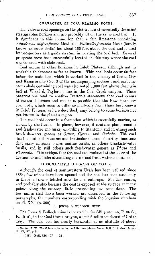
IKON COUNTY COAL FIELD, UTAH. . 367
CHARACTER OF COAL-BEARING ROCKS.
The various coal openings on the plateau are at essentially the same stratigraphic horizon and are probably all on the same coal bed. It is significant in this connection that a- thin limestone containing Admetopsis subfusiformis Meek and Eulimella funicula Meek (locally known .as screw shells) lies about 100 feet above the coal and is used by prospectors as a guide stratum in locating the coal bed. Several prospects have been successfully located in this way where the coal was covered with slide rock.
Coal occurs at other horizons in Colob Plateau, although not in workable thicknesses so far as known. Thin coal beds occur 60 feet below the main bed, which is worked in the vicinity of Cedar City and Kanarraville (No. 8 of the accompanying section), and carbona ceous shale containing coal was also noted 1,000 feet above the mainbed at Wood & Taylor's mine in the Coal Creek canyon. These observations tend to confirm Dutton's statement that coal occurs at several horizons and render it possible that the New Harmony coal beds, which seem to differ so markedly from those best known in Colob Plateau, as here described, may belong to some horizon not yet known in the plateau region.
The coal beds occur in a formation which is essentially marine, as shown by the fossils. In places, however, it contains plant remains and fresh-water mollusks, according to Stanton,0 and in others^ such brackish-water genera as Ostrea, Cyrena, and Corbula. The coal itself contains thin seams and lenticular masses of earthy limestone that carry in some places marine fossils, in others brackish-water fossils, and in still others such fresh-water genera as PJiysa and Planorbis. -It is evident that the coal accumulated at the shore of the Cretaceous sea under alternating marine and fresh-water conditions.
DESCRIPTIVE DETAILS OF COAL.
Although the coal of southwestern Utah has been utilized since 1854, few mines have been opened and the coal has been used only in the small towns located near the coal outcrops. For this reason, and probably also because the coal is exposed at the surface at many points along the outcrop, little prospecting has been done. The few mines that have been worked are described in the following paragraphs, the numbers corresponding with the location numberson PI. XXI (p. 360).
1. JONES & BULLOCK MINE.
The Jones & Bullock mine is located in the SE. \ sec. 36, T. 36 S., E. 10 W., in the Coal Creek canyon, about 8 miles southeast of Cedar City. The coal bed lies nearly horizontal at an altitude of about
oStanton, T. W., The Colorado' formation and its invertebrate fauna: Bull. U. S. Geol. Survey No. 106, 1893, p. 36.
9411 Bull. 316 07 24 .
368 CONTRIBUTIONS^ TO ECONOMIC GEOLOGY, 1906, PART II.
7,200 feet, the coal-bearing formation, which farther south caps the plateau at an altitude of nearly 10,000 feet, having been faulted down so that the coal is brought within 50 feet of the bottom of the canyon. The mine is located near the wagon road between Cedar City and Panguitch. and is more easily accessible than any other workings visited in southwestern Utah. It has been operated more or less continuously since 1890, with a maximum output of about 300 tons a year. An entry has been run in on the coal bed for 250 feet. Little care has been exercised in working the mine and the entry has been broadened by the removal of the coal, the waste piled in the vacated space being in places the only support for the roof. The section exposed in the mine is as follows:
Section of coal bed in Jones & Bullock mine.Ft. in.
Coal, impure, discarded in mining.............................. 1Clay.......................................................... 8}Coal.......................................................... 3 104
The surface is covered with slide rock at this place and no indication was observed of coal at other horizons.
2. CLUFF (JENSEN) MINE.
The Cluff or Jensen mine, now owned by Peter Feiff, is located in sec. 35, T. 36 S., R. 10 W., in the Coal Creek, canyon, 7 miles east of Cedar City. The coal-bearing formation is here faulted down, as already described, bringing the coal bed to the bottom of the canyon. The mine was opened in 1885. The entry, which is driven in on the coal bed, is said to be 600 feet long and the coal 54 to 6 feet thick.The mine was inaccessible at the time of the writer's visit, and apparently had not been worked for several years.
3. WOOD & TAYLOR MINE.
The Wood & Taylor mine is located in the NW. \ sec. 4, T. 37 S., R; 10 W., in the canyon of the south fork of Coal Creek, about 7 miles southeast of Cedar City and near the top of the plateau, at an altitude of about 8,900 feet. In order to reach it an ascent of 2,000 feet or more must be made up the precipitous side of the canyon. The difficulty of hauling coal from such a place materially lessens the value of the mine.
The mine was opened in 1881 and has been worked more or less continuously since that time. The market is local and very small, little of the coal being used outside of Cedar City. The average output is reported to be about 50 tons a year, with a maximum of 250 tons. The coal bed is nearly horizontal and is overlain by about
IBON COUNTY COAL FIELD,, UTAH. 369
1,000 feet of rock. An entry has been run in on the coal bed for 390 feet from the face of the cliff. At the end of the entry the following section was measured :
Section of .coal bed in Wood & Taylor mine.
Limestone containing Cyrena securis Meek? Ft. in: Coal, bony discarded in mining. . ............................. 2
Clay..... ............. ....................................... 5Coal......;. . ................................................. 10$ -Shale, carbonaceous, containing numerous specimens of Physa,
Planorbis, and perhaps other fresh-water shells. .............. 1Coal.......................................................... 6 'Clay........ . ................................................. 3i 'Coal.......................................................... 2 1Clay......;.............................:............!........ 1 ...Coal.......................................................... 2 1Limestone. ..
8 5
Coke is said to have been made from this coal many years ago and used locally for the extraction of iron from the ores that occur in great abundance in the Iron Mountains. The coke is said to have been satisfactory for smelting purposes. For some time iron was produced at the1 rate of 3 or 4 tons a day, but its quality was poor, and smelting was discontinued when the advent, of railroads made possible the importation of better iron from the East. Coke made from the Wood & Taylor coal is said to have been used successfully also in the Horn Silver smelter, but for some reason coking has not been continued. .
A quarter of a mile north of the old Wood & Taylor mine a new one, No. 4 of the map, has been opened on the same coal bed, but no coal has yet been shipped.
5. LEYSON MINE.
The Leyson mine is located in the SE. J sec. 33, T. 36 S., R. 10 W., about a mile north of the Wood & Taylor mine, but is not now in operation. It is said to have been the first mine opened in Utah, and was operated from 1854 until 1890. The first coke ovens in southwestern Utah were built near this mine and the early settlers used the coke for smelting iron. Later 200 to 300 tons of it were hauled to Frisco for smelting purposes.
OTHER OPENINGS IN COAL CREEK CANYON.
Several openings have been made in the canyon of Coal Creek and abandoned for various reasons. Some of these openings are indicated on the map without location number, but the location of the Lunt mine (No. 6), so called, although it was little more than a prospect, is shown for the purpose of marking that part of the accompanying
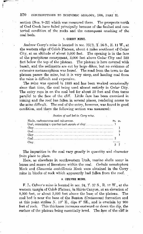
370 CONTRIBUTIONS TO ECONOMIC GEOLOGY, 1906, PART II.
section (Nos. 9-22) which was measured there. The prospects north of Coal Creek have failed principally because of the faulted and con torted condition of the rocks and the consequent crushing of the coal beds.
7. CORRY MINE.
Andrew Cony's mine is located in sec. 25(?), T. 36 S., R. 11 W., at the western edge of Colob Plateau, about 4 miles southeast of Cedar City, at an altitude of about 9,000 feet. The opening is in the face of the precipitous escarpment, 3,000 feet above Cedar City and 500 feet below the top of the plateau. The plateau is here covered with basalt, and the sediments are cut by large dikes, but no evidence of extensive metamorphism was found. The road from the town to the plateau passes the mine, but it is very steep, and hauling coal from the mine is difficult and expensive.
The mine was opened in 1885 and has been worked occasionally since that time, the coal being used almost entirely in Cedar City. The entry runs in on the coal bed for about 50 feet and then turns parallel to the face of the cliff. Little care has been exercised in .mining and the roof has fallen in several places, rendering access to the mine difficult. The end of the entry, however, was found in good condition, and there the following section was measured:
Section of coal bed in Corry mine.
Shale, carbonaceous and calcareous. Coal, containing a quarter-inch streak of clay'. .............Clay.....................................................Coal. . ...................................................Clay..............:......................................Coal.....................................................
Ft. ....... 1
....... 2
in.
151
3 7
The impurities in the coal vary greatly in quantity and character from place to place.
Here, as elsewhere in southwestern Utah, marine shells occur in lenses and seams of limestone within the coal. Corbula, nematopJiora Meek and Glaucoma coalvillensis Meek were obtained in the Corry mine in blocks of rock which apparently had fallen from the roof.
8. CULVER MINE.
F. L. Culver's mine is located in sec. 24, T. 37 S., R. 11 W., at the western margin of Colob Plateau, in Shirts Canyon, at an elevation of 8,900 feet, or about 3,000 feet above the base of the plateau. The coal bed is near the base of the Benton (Cretaceous) formation and at this point strikes N. 10° E., dips 8° SE., .and is overlain by 900 feet of rock. This thickness increases eastward or down the dip, the surface of the plateau being essentially level. The face of the cliff is
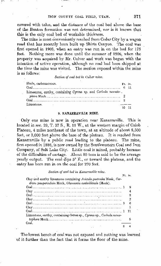
IRON COUNTY COAL FIELD, UTAH. 371
covered with talus, and the distance of the coal bed above the base of the Benton formation was not determined, nor is it known that this is the only coal bed of workable thickness.
The mine is most conveniently reached from Cedar City by a wagon road that has recently been built up Shirts Canyon. The coal was first opened in 1903, when an entry was run in on the bed for 175 feet. Nothing more was done until the summer of 1906, when the property was acquired by Mr. Culver and work was begun with the intention of active operation, although no coal had been shipped at the time the mine was visited. The section exposed within the mineis as follows:
Section of coal bed in Culver mine.
Shale, carbonaceous. Ft. in. Coal.......................................................... 0 11Limestone, earthy, containing Cyrena sp. and Corbula nemalo-.
phora Meek................................................ 2Coal.......................................................... 2Limestone. _____
10 11
9. KANARRAVILLE MINE.
Only one mine is now in operation near Kanarraville. This is located in sec. 29, T. 37 S., R. 11 W., at the western margin of Colob Plateau, 4 miles northeast of the town, at an altitude of about 8,500 feet, or 3,000 feet above the base of the plateau. It is reached from Kanarraville by a public road leading to the plateau. The mine, first opened in 1886, is now owned by the Southwestern Coal and Iron Company, of Salt Lake City. Little coal is mined, probably because of the difficulties of cartage. About 80 tons is said to be the average yearly output. The coal clips 5° E., or toward the plateau, and the entry has been run in on the coal for 270 feet.
Section of coal bed in Kanarraville mine.Ft. in.
Clay and earthy limestone containing Avicula gastrodes Meek, Car-dium pauperculum Meek, Glauconia coalvillensis (Meek).
Coal............................................................ 1 9Clay ................:......................................... 4Coal........................................................... 2Clay...........:................................!.............. 2Coal...................................'........................ 3 6Clay........................................................... 1Coal........................................................... 1 11Limestone, earthy, containing Ostrea sp., Cyrena sp., Corbula nema-
tophora Meek................................................ 5Coal.
The lowest bench of coal was not exposed and nothing was learned of it further than the fact that it forms the floor of the mine.
872 CONTRIBUTIONS TO ECONOMIC GEOLOGY, 1906, PART II.
. About half a mile north of the Kanarraville mine is an old opening, coal from which is said to have been coked years ago. The ruins of .the old ovens are still there, but nothing further was learned in regard to it.
10. NEW HARMONY MINES.
Several mines are located in sec. 32, T. 27 S., R. 13 W., about 4 miles north of New Harmony, on the east flank of one of the spurs of Pine Valley Mountain, at an altitude of about 6,000'feet. Preliminary surveys show that a branch might easily be constructed connecting the mines with the San Pedro, Los Angeles and Salt Lake Railroad, about 40 miles to the west.
The coal-bearing sediments consist of dark-colored shale, sandstone, and earthy limestone. The base of the formation was not seen and the upper 600 feet are poorly exposed. The rocks are faulted and the sequence of the beds can not be determined without much detailed work. A section, however, has been measured across a part of the coal-bearing strata by Robert A. Kirker, who has kindly permitted its use in this report. The measurements were made in shafts and prospect entries and are thought to be exact. - Mr. Kirker states that a coal bed 9 feet 4 inches thick occurs below the base of the section and two beds 4 feet 10 inches thick and 5 feet 2 inches thick above the top, but they are imperfectly known, being exposed only in open cuts, and their position in the column has not been determined.
Section of a part of the coal-bearing beds near New Harmony, Utah.
[By Robert A. Kirker.]Ft. in.
Igneous intrusive.........................._................... 10 4 Shale, calcareous............................................ 10 4
Sandstone.................................................. 9 5Coal, bony................................................... 4 8Clay..........................................:............... 2 10Coal, bony.................................................... 9 5Sandstone.................................................. 17 10Coal No. 3 (sample for analysis No. 6)......................... 4 5Shale..................................!..."...-.............. 3Limestone, fossiliferous...................................... 15Sandstone.................................................. 9 5Clay.................'............-...................-....... 2 10Shale........................:..........-................... 3Coal No. 4 (sample for analysis No. 7)........:................ 4 8Clay shale................................................... 2 10Coal, bony................................................... 1 11Fire clay.................................................... 5 2Shale, dark.......'.................................:........ 4 8
. Shale........................................................ 2 10Sandstone.................................................. 11 3Coal......................................................... 3Limestone, earthy............................................ 4 8
IRON COUNTY COAL FIELD, UTAH. . 378
Ft. in. Shale, calcareous............................................ 2 10Coal, bony................................................... 5 8Clay shale................................................... 2 10Coal, bony................................................... 1 5Shale, dark................................................. 1 5Clay.......................................................'.. 1 11Limestone, gray, shaly........................................ 9 5Coal, bony.............. .................................... 1 11Shale, calcareous............................................. 2 10Shale, green................................................ 4 1Coal, bony.........................'.......................... 5 4Shale, black................................................. 5Igneous intrusive.
The coal-bearing rocks belong to the Benton (Cretaceous) forma tion, as shown by the following fossils found at this locality:
Ostrea sp. Glaucoma coalvillensis (Meek);Cyrena securis Meek? Chemnitzia? sp.Corbula neinatophora Meek. Planorbis.
The fauna is the same as that of the coal-bearing rocks of Colob Plateau, but does not prove that the New Harmony coal occurs at the same horizon as that of the plateau, inasmuch as these fossils occur through the entire thickness of the formation. The coal at Kanarra- ville and Cedar City is near-the base of the Benton, while that at New Harmony is near the top of'whatever Benton is there present. The overlying rocks were removed by erosion previous to the deposition of the Eocene, which here rests upon the Benton, and consequently it was impossible to determine whether the New Harmony coal occurs at the same horizon ^s that of the plateau, or whether it occurs at some higher horizon of which little is yet known. The New Harmony mines are only 12 miles in a straight line from the nearest outcrop of coal in the plateau, a distance apparently too small to account for the great difference in the character of the formation and the number of coal beds on the assumption that the coals of both localities belong to the same horizon.
Owing to the crushed and contorted condition of the strata near New Harmony, there is a possibility that the.several coal beds reported by Mr. Kirker may be to some extent due to duplication by faulting, the difference in thickness and character of the coal being caused by crushing. This possibility was carefully considered by Mr. Kirker in making his section, and the writer found no evidence that his conclusion in reference to the number of coal beds is not correct.
Resting unconformably upon the coal-bearing rocks is a formation consisting of conglomerate at the base, overlain by pink shale and
874 CONTRIBUTIONS TO ECONOMIC GEOLOGY, 1906, PART II.
coarse, friable sandstone, with deep-red or vermilion sandstone, shale, and pink cherty limestone near the top. This formation is identical in physical character with the Eocene sediments of the plateau to the east, and although no fossils were obtained to confirm the correlation, it is unquestionably of Eocene age. This formation, together with the underlying coal measures, is faulted and intersected by dikes of andesite and rhyolite; it is also overlain by masses of the same rocks.
QUALITY OF COAL.
Seven samples of coal were collected from the Iron County mines. The samples were taken across the beds, quartered and pulverized in the mines, and sent in sealed cans to the chemical laboratory of the United States Geological Survey fuel-testing plant at St. Louis, Mo. The results are as follows:
Proximate analyses of coals from Iron County, Utah.
[F. M. Stanton, analyst.]
Analysis of sample as received:
Ash......................................
Analysis of air-dried sample:
Ash......................................
I.
3687
13.'2035.5841.759.474.42
5.40
8.2437.6244.1310. 014.67
II.
3760
4.9237.9643.1813.946.56
2.10
2.8838.7744.1114.246.70
III.
3761
5.2439.8243.4411.506.81
1.70
3.6040.5144.1911.70
6.93
IV.
3762
8.5436.4546.228.795.85
2.30
6.3837.3147.319.005 99
, V.
3830
13.3538.3442.955.365.74
5.00
8.8040.3545.215.646.04
VI.
3793
11.0110.3936.0942.513.27
7.90
3.3811.2839.1846. 163.55
VII.
3794
4.615.11
47.3142.974.44
2.40
2.265.24
48.4744.03
A IW
I. Sec. 24, T. 37 S., R. 11 W.; near top of plateau, altitude 8,900 feet.II. SE. J sec. 4, T. 37 S., R. 10 W.; Coal Creek canyon, altitude 7,900 feet.III. Sec. 25 (?), T. 36 S., R. 10 W.; near top of plateau, altitude about 8,700 feet.IV. SE. I sec. 36, T. 36 S., R. 10 W.; Coal Creek canyon, altitude 7,200 feet.V. Sec. 28, T. 37 S., R. 11 W.; near top of plateau, altitude 8,500 feet.VI. Four miles north of New Harmony; altitude 6,200 feet.VII. Do.
The coal of the plateau, so far as examined, has not been notably affected by local metamorphism. It is uniform in character, and black and glistening in appearance when first taken from the mine, although it soon slacks when exposed to the air. It is locally called black lignite, but in the absence of ultimate chemical analyses no attempt is here made to classify it.
More is to be said, however, of the New Harmony coal, which has been greatly disturbed by faulting, crushing, and intrusions of igne ous rock and metamorphosed to a semianthracite. The develop ment of the coal prospects is yet at an experimental stage, and in few places was clean, uncrushed coal to be found. The samples taken in the usual way across the beds include much foreign matter from
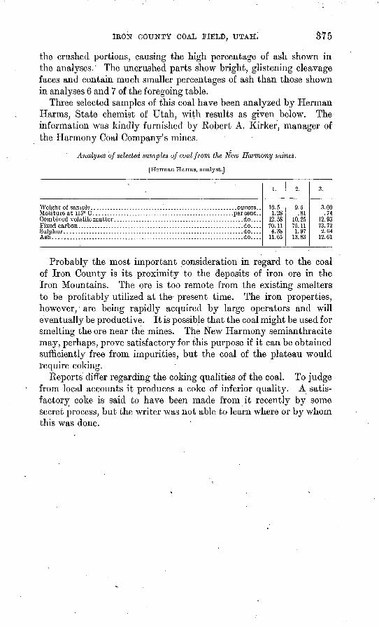
IEOK COUNTY COAL FIELD, UTAH. 375
the crushed portions, causing the high percentage of ash shown in the analyses." The uncrushed parts show bright, glistening cleavage faces and contain much smaller percentages of ash than those shown in analyses 6 and 7 of the foregoing table.
Three selected samples of this coal have been analyzed by Herman Harms, State chemist of Utah, with results as given below. The information was kindly furnished by Robert A. Kirker, manager of the Harmony Coal Company's mines.
Analyses of selected samples of coal from the New Harmony mines.
[Herman Harms, analyst.]
Moisture at 115° C.............................Combined volatile matter. ....................Fixed carbon ..................................
Ash ...........................................
......................percent...........................do.............................do.............................do.............................do....
1.
10.51.28
12.5870.114.38
11.65
2.
9.5.81
10.2575.111.97
13.83
3.
3.00.74
12.9373.722.04
12.61
Probably the most important consideration in regard to the coal of Iron County is its proximity to the deposits of iron ore in the Iron Mountains. The ore is too remote from the existing smelters to be profitably utilized at the present time. The iron properties, however, are being rapidly acquired by large operators and will eventually be productive. It is possible that the coal might be used for smelting the ore near the mines. The New Harmony semianthracite may, perhaps, prove satisfactory for this purpose if it can be obtained sufficiently free from impurities, but the coal of the plateau would require coking.
Reports differ regarding the coking qualities of the coal. To judge from local accounts it produces a coke of inferior quality. A satis factory coke is said to have been made from it recently by some secret process, but the writer was not able to learn where or by whom this was done.